Article

Territorial Prospective to Sustainability: Strategies for Future Successful of Water Resource Management on Andean Basins

by
Christian Mera-Parra
1,2,*,
Priscilla Massa-Sánchez
1,3,
Fernando Oñate-Valdivieso
1,4 and
Pablo Ochoa-Cueva
1,5
1
Master’s in Water Resources, Universidad Técnica Particular de Loja, San Cayetano Alto s/n, Loja 1101608, Ecuador
2
Faculty of Civil Engineering, Universidad Politécnica Salesiana Sede Cuenca, Calle Vieja 12-30 y Elia Liut, Cuenca 010105, Ecuador
3
Department of Economics, Universidad Técnica Particular de Loja, San Cayetano Alto s/n, Loja 1101608, Ecuador
4
Department of Civil Engineering, Hydrology and Climatology Research Group, Universidad Técnica Particular de Loja, San Cayetano Alto s/n, Loja 1101608, Ecuador
5
Department of Biological and Agricultural Sciences, Universidad Técnica Particular de Loja, San Cayetano Alto s/n, Loja 110107, Ecuador
*
Author to whom correspondence should be addressed.
Land 2022, 11(7), 1100; https://doi.org/10.3390/land11071100
Submission received: 20 June 2022 / Revised: 4 July 2022 / Accepted: 11 July 2022 / Published: 18 July 2022

Abstract

:
In Latin America, water resource management in some areas is difficult when all parts of a system are not considered (including its dynamism). Therefore, it becomes necessary to prepare instruments that facilitate management using a comprehensive approach. This study aimed to develop a methodology that allows one to conduct a prospective analysis of water management over delimited territories. The Zamora Huayco basin was chosen as the study area. This work included a survey of physical-natural, socioeconomic, and political-institutional variables, as well as a system structural analysis. Also, the generation of future scenarios and the strategic and tactical orientation for the integrated management of water resources. The results show that, of the 23 variables used, 19 were classified as key system variables. Most of the variables had strong impacts on each other, but at the same time these were highly receptive to changes. The behavior of change, proposed for the different uses and land cover in the basin for 2029, was considered as the objective scenario, highlighting the gain in forest areas and shrub vegetation. The strategic plans proposed in this methodology consider the structuring and collecting information in a single repository, creating communication channels between stakeholders and decision-makers.

1. Introduction

Integrated water resources management (IWRM) encourages the coordinated acquisition and handling of water resources, with the participation of diverse stakeholders, from those related to natural water storage to end users, in order to develop economic and social welfare without risking vital ecosystems sustainability [1,2,3]. In this approach, the foresight techniques application has gained popularity, since it considers the most probable changes of a system and established a strategic plan to achieve a desirable future, as well as precautionary measures to control this transition [1,4,5,6].
Water consumption has grown exponentially worldwide since the previous decade, which is linked to population growth and economic development. This has caused problems associated with competition for its use and has affected the supply ecosystems [1,7]. Until the end of the last century, water management in the world focused mainly on meeting demand [8,9]. Also, the availability of water was apparently sufficient, and it was not necessary to analyze in depth all of the aspects related to its management. However, the scenario of global water stress reached in recent times, with a supply that decreases over to a growing demand, raises the search for new management mechanisms for water governance [10] since the traditional, fragmented and sectoral approach, is no longer valid [11,12].
Latin America has large reserves of fresh water in its territory, as it concentrates 31% of the planet’s sources. However, over many significant supply areas exist conflicts between stakeholders, so, water resources sustainable exploitation turns difficult, situation related to several investigators [2,13,14]. Consequently, the use of different methods and instruments that facilitate a coordinated management has increased. In particular, for water use planning, major advancements have been developed in prospective techniques through structural analysis for decision-making, such as those carried out by [1,15].
Structural analysis is a prospective method. Its objective is to determine the main influencing and dependent variables (that is, the key variables for the evolution of the system). After listing the variables, its relation is searched among each other, and the scenarios are built. These scenarios are essentially the combination of variables and its change. The most common change scenarios prepared in an academic or research context, are the negative, positive or objective, and tendential. The negative scenario is related to the worst change over the system. The positive or objective scenario is the desirable future of the system, and the tendential scenario groups together the predicted change in each variable. All of these scenarios are developed based on expert criteria [16,17].
Within territorial prospective methodology, the generation of future scenarios is reached by identifying and classifying the relationships between different variables that characterize a system. This is the central objective of the whole process since it allows synthesize a system through the definition of key variables, and with them, propose hypotheses of change. With the combination of hypotheses of change, different scenarios are built up. One must be selected as a desirable, at which time finally the strategies to achieve it can be detailed. Some application examples exist, although their use in IWRM is limited. Therefore, the current study is based on the methodology developed by [17], for territorial management modified for water resource management.
Ref. [1] conducted out a structural analysis of the water resource management system in the Nenetzingo river basin (Mexico). They identify and classify the system variables and give a strategic orientation to the management of water resources within the basin. They used the cross-impact matrix multiplication applied to classification (MICMAC) analysis, but made-up modifications to the original method. Nevertheless, the variables used did not contain actual data of the basin, neither in current nor future conditions. A total of 49 relevant variables of the system were identified, along with 22 key variables.
Analogously, ref. [15], had the objective of investigate the methodology associated with the generation of strategic scenarios within a hydrographic basin. They integrated the theories of structural analysis, actor analysis and morphological analysis oriented to water resource management, highlighting the importance of considering the social, economic, and environmental dynamics within the territory, they worked with 11 variables for structural analysis. This study was conducted in the hydrographic basin of the Ararandeua river (Brazil), which is characterized by having a high rate of conflicts over water use.
Ref. [4] applied the MICMAC method, in order to identify the structure of key variables for environmental management in La Concordia (Ecuador). Also identified the denotative variables to intervene in the system. Similarly, the authors of [18] identified key variables in the Ruta del Oro (Colombia) regional system, conducted a MICMAC analysis, and developed planning scenarios.
The watershed used as the study area, in the proposed methodology is the Zamora Huayco (ZH) river basin. This basin has many social, economic, and political particularities, which together to specific natural conditions, generate a highly complex system. Under the conditions described above, nonassertive policies could inhibit the proper management and conservation of water resources.
Special attention must be paid to developing approaches for water management among stakeholders and decision-makers. Through guiding actions that channel safeguarding hydrological services and seeking to improve the living conditions of communities located within the hydrographic basin [14,19]. The policies must be linked with the study and monitoring of natural resources as an aid to decision-making [11]. According to this perspective, it is necessary to represent a system in all its dimensions and that includes all of the variables related to an efficient water resource management through a strategic plan to achieve it. Therefore, this study aimed to develop a methodology that allows one to conduct prospective analysis of water management systems such as watersheds, based chiefly on the phases proposed by [17].
Firstly, a survey of physical-natural, socioeconomic, and political-institutional variables was carried out, along with the analysis of the relationship between them. Then, future scenarios were generated, appending landscape management and water resource management. Based on an objective scenario, possible strategic guidelines were detailed to reach it.

2. Materials and Methods
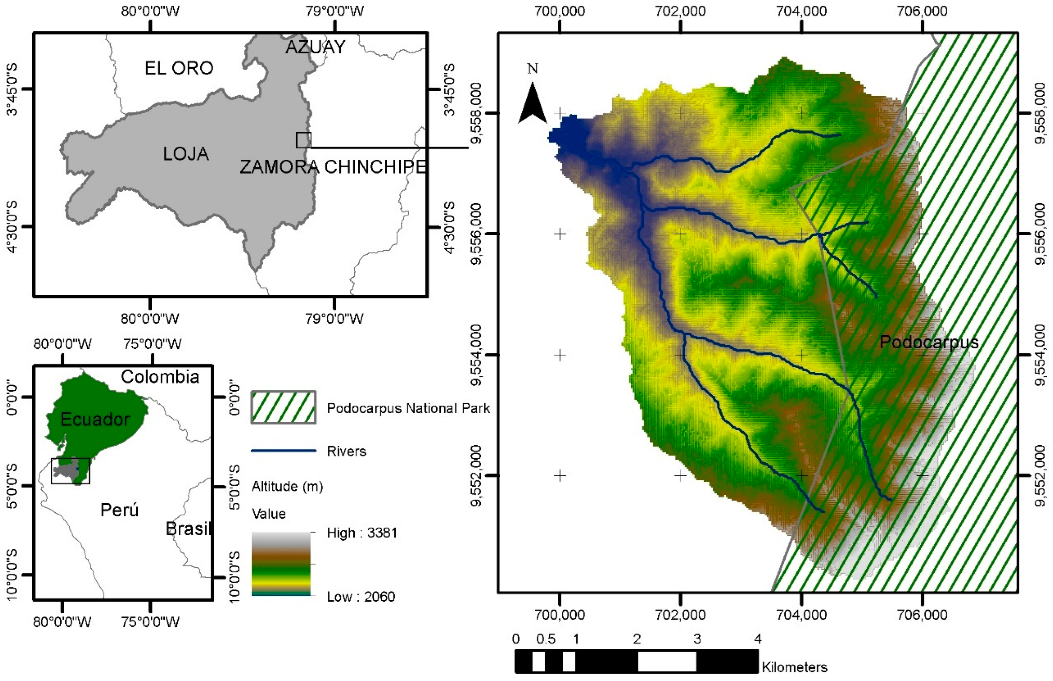
2.1. Study Area

The Zamora Huayco (ZH) basin has 3806.52 ha, and is located in the inter-Andean region of the Loja province in southern Ecuador between the geographic coordinates 4°04′03′′–3°59′42′′ S and 79°11′54′′–79°07′35′′ W (Figure 1). The elevation ranges of this basin are from 3380 to 2560 m asl, and its average slope is 0.65 m/m.
The basin’s climate is cold temperate mesothermal [20], characterized by an average annual temperature between 12 °C and 18 °C and average annual precipitation of 1047 mm. The wet season occurs from December to May and the dry season from June to November [21].
Natural vegetation predominates in the basin, although since 1976, the basin’s forests have decreased by 19.3% [22]. Also, within the ZH basin, there are two water catchments for potabilization that supply approximately 50% of the demand of the city of Loja with 450 l/s [23].
The buffer zone of the Podocarpus National Park (PNP) is located in the upper zone of ZH [24]. The PNP has a strong agricultural, livestock and urban pressure in the surrounding valleys, mainly in its western limits [25], including the Loja [23]. The main productive activities in the lower zone of ZH are agriculture and cattle raising [26,27].

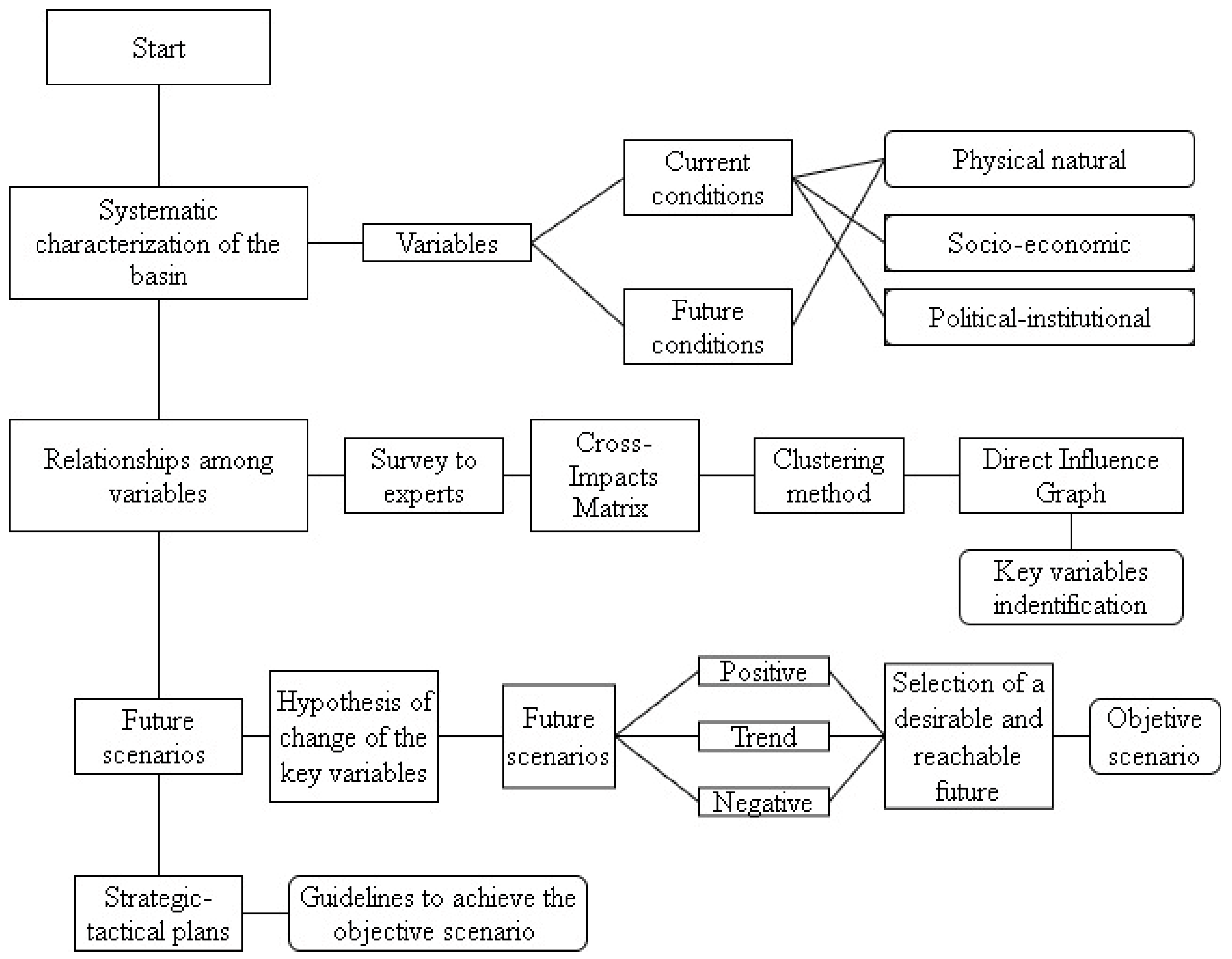
2.2. Prospective Analysis

In this research, a methodology for the systematic characterization of a watershed and the generation of future scenarios was developed. It is focused on the assurance of ecosystem services, to the current and futures natural conditions. To identify key variables, a cross impacts matrix was applied [28], but using a different scale than the traditional one. Also, a clustering method was applied to classify the variables and identify the key ones; this procedure is detailed in the flowchart in Figure 2.
Different stages were generated and included considering what inputs can help us propose a decision-making system that does not depend on the subjectivity or bias of human selection; but that includes the holistic perspective of watershed management, that requires the participation of stakeholders and decision-makers, within the territorial planning of the basin.

2.2.1. Systematic Characterization of the Basin

A strategic diagnosis was included, which implied a combination of physical-natural, socio-economic, and political-institutional variables [17]. Socio-economic and political-institutional variables encompassed details under current conditions and physical-natural variables included current and projected data to a close time horizon, so that changes can be able controlled.
The natural physical variables were obtained, for current conditions and projected to a 10-year time horizon, through remote sensing techniques and hydrological modeling; for more details you can review [24]. While, the characterization of the socio-economic variables, a survey was carried out in the basin populated area, and for the political-institutional variables, an extensive bibliographic review of current regulations and laws were carried out.

2.2.2. Relationships Description among Variables and Identification of Key Variables

The analysis of relationships among variables was carried out using the DELPHI methodology [29]. A survey was prepared, and experts’ participation was requested. Within this survey a brief description of identified variables was included, to handle uniformity in concepts. Also included were the objective of the consultation and procedure for completing the survey.
Experts on IWRM issues from different areas such as economic and social science, hydrology, forestry, environment, agriculture, and civil engineering were selected; from the academic, both public and private. Counting thus on the criteria of 17 experts, plus the criteria of the authors of this study. The final matrix was determined by calculating the statistical model from the matrix database [17].
The experts were asked to fill in the structural analysis matrix, or cross-impacts matrix, placing the variables in both rows and columns and evaluating the impact of each variable on the others, assigning values of 0 (no impact), 1 (slight impact), 2 (strong impact) and 3 (very strong impact). This scale was chosen since by exposing the variables to different degrees of sensitivity, it increases the possibility of having results that a priori could be counterintuitive [16,30]. A potential scale was excluded since it might highly affect the dynamism among variables, hindering the setting of an objective horizon in the near future [1], so, the most likely change was chosen. Finally, a cartesian plane was generated, called direct influence graph (DI), (abscissa and ordered correspond to horizontal and vertical summation of each variable in the structural matrix) [31].
To facilitate the selection of key variables by dividing the contiguous classes into different ranges, a data clustering method known as Jenks natural breaks (JNB) was applied, this tool has the characteristic of minimizing the squared deviation within each aggrupation [1,32]. This allowed the selection of variables that have reached a higher margin due to their higher score and eliminating variables that have obtained a lower ranking, and therefore correspond to a low influence within the watershed system.
A total of four subdivisions were considered, for a low, medium low, medium high and high level. Giving a numerical value to the classification of variables according to [16], the excluded variables are in the low, medium low and upper middle zone levels, and the key variables are distributed in the high level. In total, 23 variables and 529 influence evaluations were achieved.

2.2.3. Future Scenarios Construction

Scenarios were generated once the key variables had been obtained. The morphological space (narrative of future hypotheses or exploration of hypothesis of change) was constructed, considering an objective time horizon to the year 2029. Different hypotheses for the identified variables were described considering a positive change (desirable in the future), a trend change and a negative change. The scenarios result from the combination of hypotheses [17,33].

2.2.4. Strategic-Tactical Plans

This stage involved generating guidelines to achieve the objective scenario [17]. The guidelines were mainly oriented towards water resource conservation, flows regulation and ecosystem service assurance. Both, strategic and adaptive actions, were included due to the existence of variables that cannot be controlled, such as municipal legislation or climate change. A similar stage is placed at [34], and is highlighted as “move from prospective reflection to strategic action”

3. Results

3.1. Basin Systemic Characterization

3.1.1. Physical-Natural Domain

Physical-natural domain was extensively detailed in part 1 [24], dimensions such as LULC, water recharge estimation, flash floods, hydrological modelling, water availability and meteorological projections were quantified, and its results were associated with the narratives of future hypotheses.

3.1.2. Socioeconomic Dimension

Mostly agricultural related activities are made in the lower zone of the ZH basin [22], close to two catchwaters for potabilization [23]. While, in the upper zone, the buffer of the PNP is located, where productive or extraction activities are not allowed [27,35].
In the ZH basin, several anthropogenic problems were identified, mainly related to demographic pressure and the unequal distribution of resources and services. About 43% of the population that lives in the basin, does not have sewerage service. These are forced to use alternative sanitation solutions, such as septic tanks, cesspools, and latrines. Approximately 44% of the population is water supplied from rivers, springs, or ditches. In terms of public perception, 36% of the residents consider that the water they use at home is of poor quality. Around 36% of people have endured failure of the sewer system in their homes. Therefore, water sources are susceptible to contamination, mainly by these alternative sanitation solutions.
The survey conducted in the basin shows that 43% of the people, lived in other sectors of the city and settled in the area for work reasons. It has caused an advance of the agricultural frontier, approaching fields to areas with high slopes, increasing erosion risk and organic surface layer loss. Colonization processes, in addition to constant immigration, have caused changes of LULC and an increase in the water demand.
Low purchasing power, lack of social security (whether due to employer affiliation or peasant insurance), low level of schooling, poor employer relations, among others, have forced a large percentage of residents of ZH to develop agricultural activities that complement their income, which implies, as in previous cases, an advance of the agricultural frontier. About 48% of the population states that work more than 40 h per week, 26% work less than 40 h, and 26% do not work (mostly students, but occasionally they help with agricultural activities). People who work as salaried employees receive on an average $457 and the people who are self-employed $287. Our results do not agree with [26], 62% of the population has a productive agricultural activity, mainly related to cattle and short-cycle crops, mostly on waterways riversides. Generally, the population of the area will decrease at a rate of close to 1.56% per year [36].

3.1.3. Political-Institutional Dimension

On the upper eastern flank is the buffer zone of PNP, which maintains independent policies regarding the monitoring and protection of its territory. According to the Ministry of the Environment (MAE), it has a high conservation priority since it is part of the National System of Protected Areas (SNAP), and of the subsystem known as Heritage of Natural Areas of the State (PANE). The SNAP has among its priorities, the preservation of biological diversity, promoting the sustainable management of wild lands, encouraging ecotourism, in addition to maintaining genetic flows [37].
SNAP is a differentiated and shared territorial administration tool, integrated by state, municipal, community and private actors (MAE, 2016). The SNAP is mainly managed with the financing of fiscal resources and subsidize from the Global Environment Facility (GEF). For 2012, $478,584 corresponding to 2.28% of the total SNAP budget, was allocated to the PNP [35].
SNAP has a budget deficit [38], accuses a lack of personnel, and maintains 95% of its lands with land tenure problems [26,35,37]. But it has achieved good results, particularly in PNP, which maintains a very good state of conservation [39]. In the ZH basin, within the area shared with the PNP, any exploitation or occupation is prohibited [35].
Also, there are conservation areas within the ZH basin, constituted as municipal domain properties, in 2007. Loja’s GAD issued the following regulations: “Ordenanza para la protección de las microcuencas y otras áreas prioritarias para la conservación del cantón Loja”, which was reformed in 2015 due to the Development and Land Use Plan update [40]. This ordinance aims to obtain economic resources to keep water sources in a state of conservation.
The non-governmental organization (NGO) Nature and Culture International (NCI), carried out projects within ZH, aimed at management and protection of protected areas. Due to the importance of their environmental services, received support from Lojas’s GAD until 2009 [41]. After Loja’s accession in 2009 to the Regional Water Fund (FORAGUA) mercantile trust, the assets acquired by NCI were transferred to FORAGUA [26]. The trust objective is to assure the conservation processes in the water sources, through the adequate investment of the environmental fees charged by the different municipalities. With the reform approved in 2015, the use of these resources is nowadays managed by the Municipal Drinking Water and Sewerage Unit of Loja (UMAPAL).
Land use in the basin is regulated through a zoning system, which considers the land use capacity, the current use of the land, the micro-basins that supply water for human consumption and the urban areas. The different classes of land use capacities have a weighted order and depend on variables such as the terrain slope, soil effective depth, surface texture, soil fertility, drainage, among others. ZH basin, due to its water importance and collective interest, has most of its territory classified as a conservation area [40].
According to the “Recopilación Codificada de la Legislación Municipal”, article 23, there are penalty fees for negative externalities associated with contamination in watersheds due to agricultural activities, deforestation, or forest fires, main one is a coercive fine. A prohibition is established for sanitary sewer connections with discharge to streams, rivers, or their tributaries, which may generate contamination [42]. Upstream of the water catchment points, this is ratified. However, there are areas adjacent with agricultural activities.
The ZH basin has legal mechanisms that allow different actors to seek its conservation and take advantage of its ecosystem services. At the community level, according to [26], there is a limited community organization, mainly in the Parroquia El Carmen, on the management of resources. There is no specific territorial strategic planning for the area despite the basin hydric importance.
The “Ordenanza para la protección de las microcuencas y otras áreas prioritarias para la conservación del cantón Loja” proposes an environmental tax (ET), as a percentage of the unified basic salary (UBS) and the range of consumption per m3. The use of these resources is managed by UMAPAL and must make an annual report to the city mayor, of the investment plan, indicating the destination of the funds. For example, in a range of 21 to 50 m3 of consumption, for the residential rate, ET for each m3 is 0.0085% of UBS and for the commercial and industrial rate it’s 0.020% of UBS [43].
The agreement with FORAGUA was unilaterally terminated by the Municipality of Loja, through the reform of the ordinance, however, the mercantile trust with FORAGUA was in force until 2089 with irrevocable character. FORAGUA considered a contribution (projected) of 400,000 dollars per year [44]. However, it is unclear the intervention mechanisms or the inter-institutional strategies currently carried out between both parts.
One of the initial activities of FORAGUA was the management of funds for the property purchase that are located within zones identified as water recharge zones (WRA). FORAGUA identified about 4800 ha of WRA in the water supply basins for Loja canton. Of these zones, 1887 ha were declared as municipal reserves, and 2908 ha were purchased or managed by agreement [44].
The strategic alliances spectrum is broad for the conservation of water-supplying basins, it is developed through the environmental program “Plan Nacional de Gestión Integrada e Integral de Recursos Hídricos” has annexed the Municipality of Loja, Environment Ministry, National Council of Parish Governments of Ecuador (CONAGOPARE), National Secretariat of Water (SENAGUA), Provincial GAD of Loja and communities around the influence area. The objective of this alliance is to manage the water resource comprehensively to ensure the availability, sustainable use and quality of the water resource, for various human and natural uses. Some of the specific commitments of the stakeholders consist of the georeferenced identification of degraded areas and reforestation with native forest species [45].
Due to the lack of foresight from the municipality, the work scenario lacks political stability, so management at the inter-institutional level becomes complex. The canton of Loja is a complex territorial unit, it has personnel trained in public management and with the ability to design and implement adequate policies to achieve institutional objectives, as well as to guide and control local socio-territorial processes, based on the plan of the territory management currently developed [46]. The municipality of Loja permanently continuous training of its employees; of the different directions and headquarters; and through the Ecuadorian Professional Training Service [47].

3.2. System Variables

Table 1 details the system variables developed by the research team, associated with their domain field and with a short name for the DI graph.

3.3. Key System Variables

The limits found with Jenks Natural Brakes (JNB) are presented in Table 2. Finally, 4 variables (low and close to low ranges) were discarded from the total of variables considered, obtaining 19 key system variables. Figure 3 shows a DI graph with influence/dependence areas according to JNB classification and by quadrants as established by [16].
When applying the JNB classification, the goodness of variance fit (GVF) was also determined, reaching a value of 0.9206, being close to 1 the adjustment of the classification is good [48].
Here, the excluded variables are those that, regardless of the quadrant in which these are found, are in the classification of low and close to low according to the JNB classification. Only those variables classified as close to high and high were considered as input, link, and resulting variables.
Most of the variables have been identified as link variables. These have strong impacts but at the same time are highly receptive to changes in the other variables. It is an interdependent dynamic of change. For example, there are variables such as the population increase that show a relative lower dependency and greater influence than the rest of variables, that means, a change in it would cause an alteration in the entire system, but it wouldn’t be highly influenced by a modification in other variables, it also indicates that one of these factors of change, the most important is the anthropogenic. Forecasting future changes in it will help anticipate the effects that might cause.
There are mainly variables of high influence, and high dependence, understood as link variables, such as streamflow, which has a bidirectional effect on the current and future basin dynamics since other variables depend on its availability. It is important to strategically manage these types of variables since conflicts arise around them.
The resulting variables, such as bare ground cover, were shown to have high dependence and relative less influence, them strongly depend on the input and link variables, and their effects on the other variables are minimal.

3.4. Future Scenarios

Table 3, Table 4 and Table 5 show the different future scenarios with a change hypothesis by variable. Strategic intervention plans must be associated with a positive scenario, as it is desirable in the future. The hypotheses of the variables of the natural physical domain were adjusted to the projections for 2029 developed in Mera-Parra et al., 2021 [24].

3.5. IWRM Strategies and Tactics

Population increase could be considered an input variable since it has a high influence and a relatively less dependency compared to the rest of the link variables. To achieve a state of conservation on water resources, efforts must be channeled to prevent population growth. Within the basin, most of the impacts on water resources have an anthropogenic origin. As the population decreases, it is expected that agricultural activities will also decrease. Ref. [49] in a study carried out in the Vilcanota-Urubamba basin, southern Peru, the importance of considering the participatory and social approach to solve anthropogenic effects and socioeconomic disparities in IWRM is highlighted.
Most of the variables, being interdependent, are conditioned to the appearance of conflicts due to the changes that are generated in them. To reach an objective horizon, forest and shrub vegetation covers, must be extended, which implies a reduction in grassland, bare soil, agriculture, and urban cover. From this viewpoint, it becomes essential, a monitoring to, if necessary, take corrective actions and procure the increased cover of forest and shrub vegetation. The collection of information requires a participatory approach with the stakeholders to integrate different elements of information through GIS. This vision is shared by [50].
It is expected that FORAGUA will retake its intervention and consequently take the competences assumed by UMAPAL. Therefore, depending on an ET (adjusted in the future according to the conditions of the different supply basins in the city of Loja), it is estimated an increase in areas intended for conservation. Similarly, the Regional Water Fund (FORASAN) in Piura, Peru, has achieved positive results in the protection of high Andean hydrographic basins following mechanisms similar to those of FORAGUA, highlighting the importance of involving stakeholders, especially the peasants [51].
Being a PNP area shared with the ZH basin, MAE must adopt actions to ensure a good conservation of associated ecosystem services. Mainly the strengthening of alliances for monitoring and protection. Dependent on SNAP, the financing lines should not be cut. Ref. [50] shares this criterion and mentions that monitoring must include biological and chemical aspects as well as ways to transfer knowledge with decision-makers.
Control and collection of fines for negative externalities associated with the conservation of the basin must become more rigorous, to limit agricultural activities and/or deforestation, ensuring also sanction to the provocation of forest fires. While still existing private domain extensions, if these cannot be dispossessed, financial support programs must be implemented for the conservation and protection of shrub vegetation and forest. Ref. [52] mentions that, if land tenure requirements, legal restrictions, biophysical limits of land use and financial need are considered, financial support programs become attractive, not only for rural communities, if not for larger and even wealthier landowners.
These actions, in general terms, will help achieve a desired hydrological response, such as better water regulation, a lower peak flow (associated to extreme rainfall events) and a higher base flow, as well as a greater water recharge. Additionally, when observing that the areas that seek greater water recharge are above 2350 m asl, agricultural activities should be limited to this level, ref. [51] coincides in this action and adds that, to increase the resilience of the water supply, planning should focus on sources, beyond urban areas.
When evidencing a notable increase in average annual temperature and an increased tendency of high intensity rainfall, adaptive measures should be taken around climate change. Efforts should be made to protect forest areas and shrub vegetation since these are the covers that mainly regulate flow in the basin, those landscapes can help mitigate the effect of climate change on the proposed time horizon, reducing the effect of torrential floods and desertification due to hydric erosion, as long as its geographic expansion is assured.
Ref. [51] approached climate change paradigms similar to that was planned in this research, he suggests that the existing hydraulic infrastructure; designed originally to control the flow and satisfy the demand for water; will be challenged by droughts, high intensity precipitation and sediments dragged by hydric erosion, which will increase in magnitude and frequency. Therefore, those events must be estimated, the infrastructure redesigned and its conditions reestablished, if necessary, to appease the impacts. Additionally, it is essential to seek the increase of green infrastructure to mitigate the effects of climate change (floods and desertification).
To complement the holistic vision of water resource management, and given the vital importance of the basin for Loja city, it’s necessary to include in the strategies, the monitoring of flow and water quality, in streamflow where water is collected for human consumption. Ref. [50] argues that technology implemented around water should not be limited to its treatment, it should be implemented in planning phases, including knowledge transfer to facilitate decision-making.

4. Discussion

At the first stage, the proposed methodology supports the need for a solid framework of natural-physical variables, in current and future conditions. Over the analysis of the relationship between variables, it is distinguished that, the ‘potential’ influence scale, frequently used in similar cases, was ruled out to assure a more probable objective scenario.
At the phase of the morphological space (that is, the construction of future scenarios), real and therefore controllable trends were included. This aimed to increase the probability of apparition of a more probable target scenario, and therefore, a more assertive strategic plan to achieve it. It is remarkable also that over the final evaluation of the MICMAC, the clustering method applied for the automatic selection of key variables revealed that most of the variables prepared by the researchers presented high influence and dependence, and just a few variables were ruled out from later analysis.
The proposed methodology intrinsically seeks to avoid human decision bias, which could arise due to the conditions of the interviews with stakeholders and decision-makers. As well as those that could occur due to the perceptions of the researchers.
In this study case, there are mainly variables of high influence and dependence, understood as link variables. Those have strong impacts but at the same time them are highly receptive to changes, that is, there’s an interdependent dynamic of change. For example, the variable related to streamflow has a bidirectional effect on the current and future basin dynamics since other variables depend on its availability. It is important to strategically manage these types of variables since conflicts arise around them.
The resulting variables, such as bare ground cover, are shown to have high dependence and relative less influence. This strongly depends on the input and link variables, and their effects on the other variables are minimal. While the variable related to population increase has a relative lower dependency and greater influence than the rest of variables. This means that a change in it would cause an alteration in the entire system, but it would not be highly influenced by a modification of the state of any other variable and that variations in anthropogenic variables can lead to important changes and must be anticipated.

5. Conclusions

From the 23 variables considered, after the structural analysis, 4 were discarded and scenarios were generated with 19 key system variables. Most of the variables have strong impacts on each other, but at the same time these are highly receptive to changes in other variables, them are highly interdependent. This type of variable is also characterized by being associated with conflicts of interest. Therefore, an alteration in a variable must be planned and consider stakeholders and decision-makers.
The objective scenario considered the behavior of change proposed for the different land uses and covers in the basin for 2029, highlighting the gain of forest areas and shrub vegetation. Which implies a greater regulation of flow, an improvement in the protection of soil superficial layer a repowering other associated ecosystem service. A reduction in agriculture and livestock practices is also expected, mainly due to municipal intervention policies for hydric resources preservation, in addition to a negative population growth trend.
From the strategic and tactical plans, it is determined that structuring and compiling all of the information and data that may be relevant in a single GIS repository will favor decision-making. With this proposed methodology, decision-making towards the sustainable use of the water supply basins will be greatly facilitated.

Author Contributions

Conceptualization, P.M.-S.; Data curation, C.M.-P. and P.M.-S.; Formal analysis, C.M.-P.; Investigation, C.M.-P.; Methodology, C.M.-P. and P.M.-S.; Project administration, P.M.-S.; Software, C.M.-P.; Supervision, F.O.-V. and P.M.-S.; Validation, P.M.-S. and P.O.-C.; Visualization, P.M.-S.; Writing—original draft, C.M.-P.; Writing—review & editing, P.O.-C. All authors have read and agreed to the published version of the manuscript.

Funding

This research did not receive any specific grant from funding agencies in the public, commercial, or not-for-profit sectors. The APC was funded by the Universidad Técnica Particular de Loja—Ecuador.

Institutional Review Board Statement

Not applicable.

Informed Consent Statement

Not applicable.

Data Availability Statement

Some or all data and models that support the findings of this study are available from the corresponding author upon reasonable request.

Conflicts of Interest

The authors declare no conflict of interest.

References

  1. Manzano, L.R.; Díaz, C.; Gómez, M.A.; Mastachi, C.A.; Soares, D. Use of structural systems analysis for the integrated water resources management in the Nenetzingo river watershed, Mexico. Land Use Policy 2019, 87, 2–11. [Google Scholar] [CrossRef]
  2. Dourojeanni, A. Los desafíos de la gestión integrada de cuencas y recursos en América Latina y el Caribe. Desarro. Local Sosten. 2009, 3, 8. [Google Scholar]
  3. Ketema, H.; Wei, W.; Legesse, A.; Wolde, Z.; Temesgen, H.; Yimer, F.; Mamo, A. Quantifying smallholder farmers’ managed land use/land cover dynamics and its drivers in contrasting agro-ecological zones of the East African Rift. Glob. Ecol. Conserv. 2020, 21, e00898. [Google Scholar] [CrossRef]
  4. Estuardo, G.; Amílear, R.; Gómez, L. Identificación prospectiva de componentes en el proceso de gestión ambiental del Cantón La Concordia, Ecuador. Ciencia en su PC 2016, 3, 16–33. [Google Scholar]
  5. Rubio, D. Diseño de un Modelo Metodológico Para la Fase Prospectiva en Los Estudios de Ordenamiento Territorial y su Aplicación a Algunos Casos Centroamericanos. Ph.D. Thesis, Universidad Politécnica de Madrid, Madrid, Spain, 2012. [Google Scholar]
  6. Gibbs, D.A.; Flotemersch, J. How environmental futures can inform decision making: A review. Futures 2019, 108, 37–52. [Google Scholar] [CrossRef]
  7. Di Baldassarre, G.; Wanders, N.; AghaKouchak, A.; Kuil, L.; Rangecroft, S.; Veldkamp, T.I.E.; Garcia, M.; van Oel, P.R.; Breinl, K.; Van Loon, A.F. Water shortages worsened by reservoir effects. Nat. Sustain. 2018, 1, 617–622. [Google Scholar] [CrossRef]
  8. Benavides Muñoz, H.M.; Zari, J.E.A.; Fries, A.E.; Sánchez-Paladines, J.; Gallegos Reina, A.J.; Hernández-Ocampo, R.V.; Ochoa Cueva, P. Management of Hydrological Systems; CRC Press: Boca Raton, FL, USA, 2020; ISBN 9781003024576. [Google Scholar]
  9. McNabb, D.E. Integrated Water Resource Management. In Water Resource Management; Springer International Publishing: Cham, Switzerland, 2017; pp. 329–349. [Google Scholar]
  10. Kumar, P.; Liu, W.; Chu, X.; Zhang, Y.; Li, Z. Integrated water resources management for an inland river basin in China. Watershed Ecol. Environ. 2019, 1, 33–38. [Google Scholar] [CrossRef]
  11. UNEP. UN-Water Status Report on the Application of Integrated Approaches to Water Resources Management; UNEP: Geneva, Switzerland, 2012; ISBN 978-92-807-3264-1. [Google Scholar]
  12. Kennedy, K.; Simonovic, S.; Tejada-Guibert, A.; De França Doria, M.; Martin, J.L. IWRM Implementation in Basins, Sub-Basins and Aquifers: State of the Art Review; UN: Geneva, Switzerland, 2009; pp. 1–23. [Google Scholar]
  13. Bhushan, B. Introduction: Water Supply and Management. In Bioinspired Water Harvesting, Purification, and Oil-Water Separation; Springer: Cham, Switzerland, 2020; pp. 1–10. [Google Scholar]
  14. Arteaga, J.; Ochoa, P.; Fries, A.; Boll, J. Identification of Priority Areas for Integrated Management of Semiarid Watersheds in the Ecuadorian Andes. JAWRA J. Am. Water Resour. Assoc. 2020, 56, 270–282. [Google Scholar] [CrossRef]
  15. Magalhães, R.C.; Barp, A.R.B. Inovações Metodológicas Para Construção De Cenários Estratégicos Em Bacias Hidrográficas. Rev. Adm. Innov. RAI 2014, 11, 200. [Google Scholar] [CrossRef]
  16. Godet, M.; Durance, P.; García, K.; Cercle, E.; Lipsor, C.; Giget, M.; Godet, M.; Bassaler, N.; Durance, P.; Hammami, K.; et al. La Perspective Stratégique Pour Les Entreprises et Les Territoires; El Cercle des Entrepreneurs du Futur: Paris, France, 2009. [Google Scholar]
  17. Salas-Bourgoin, M. Prospectiva Territorial. Aproximación a Una Base Conceptual y Metodológica; Vicerrectorado Administrativo y del Consejo de Desarrollo Científico, Humanístico, Tecnológico y de las Artes de la Universidad de Los Andes: Mérida, Venezuela, 2013; ISBN 9789801116035. [Google Scholar]
  18. Delgado, A.M.; Pantoja, F. Structural analysis for the identification of key variables in the Ruta del Oro, Nariño Colombia. Dyna 2015, 82, 27–33. [Google Scholar] [CrossRef]
  19. Vargas-Lama, F.; Osorio-Vera, F.J. The Territorial Foresight for the construction of shared visions and mechanisms to minimize social conflicts: The case of Latin America. Futures 2020, 123, 102625. [Google Scholar] [CrossRef]
  20. INAMHI. Tipo de Climas. Available online: https://www.inamhi.gob.ec/geoinformacion-hidrometeorologica/ (accessed on 18 October 2021).
  21. Oñate-Valdivieso, F.; Uchuari, V.; Oñate-Paladines, A. Large-Scale Climate Variability Patterns and Drought: A Case of Study in South America. Water Resour. Manag. 2020, 34, 2061–2079. [Google Scholar] [CrossRef]
  22. Ochoa-Cueva, P.; Fries, A.; Montesinos, P.; Rodríguez-Díaz, J.A.; Boll, J. Spatial Estimation of Soil Erosion Risk by Land-cover Change in the Andes of Southern Ecuador. Land Degrad. Dev. 2015, 26, 565–573. [Google Scholar] [CrossRef]
  23. Alvarez, L. Disponibilidad y Demanda del Recurso Hídrico Superficial. Estudio de Caso: Subcuenca Zamora Huayco, Ecuador; Universidad Nacional de la Plata: Buenos Aires, Argentina, 2017. [Google Scholar]
  24. Mera-Parra, C.; Oñate-Valdivieso, F.; Massa-Sánchez, P.; Ochoa-Cueva, P. Establishment of the Baseline for the IWRM in the Ecuadorian Andean Basins: Land Use Change, Water Recharge, Meteorological Forecast and Hydrological Modeling. Land 2021, 10, 513. [Google Scholar] [CrossRef]
  25. Ochoa-Cueva, P.; Chamba, Y.M.; Arteaga, J.G.; Capa, E.D. Estimation of Suitable Areas for Coffee Growth Using a GIS Approach and Multicriteria Evaluation in Regions with Scarce Data. Appl. Eng. Agric. 2017, 33, 841–848. [Google Scholar] [CrossRef] [Green Version]
  26. Zarate, C. Hacia un Modelo de Ordenación Para los Territorios de Protección Natural del Área de Influencia Inmediata de la Ciudad de Loja. Microcuenca El Carmen; Universidad de Cuenca: Cuenca, Ecuador, 2011. [Google Scholar]
  27. Mejía-Veintimilla, D.; Ochoa-Cueva, P.; Samaniego-Rojas, N.; Félix, R.; Arteaga, J.; Crespo, P.; Oñate-Valdivieso, F.; Fries, A. River Discharge Simulation in the High Andes of Southern Ecuador Using High-Resolution Radar Observations and Meteorological Station Data. Remote Sens. 2019, 11, 2804. [Google Scholar] [CrossRef] [Green Version]
  28. Rojas Arboleda, M.; Pfeiffer, A.; Bezama, A.; Thrän, D. Anticipatory study for identifying the key influential factors of the biogas system in Germany contributing to the energy system of 2050. Futures 2021, 128, 102704. [Google Scholar] [CrossRef]
  29. Hsueh, S.L. Assessing the effectiveness of community-promoted environmental protection policy by using a Delphi-fuzzy method: A case study on solar power and plain afforestation in Taiwan. Renew. Sustain. Energy Rev. 2015, 49, 1286–1295. [Google Scholar] [CrossRef] [Green Version]
  30. Godet, M. Introduction to la prospective. Futures 1986, 18, 134–157. [Google Scholar] [CrossRef]
  31. Arcade, J.; Godet, M.; Meunier, F.; Roubelat, F.; Mendieta, M. Structural analysis with the MICMAC method & Actor’s strategy with MACTOR method. In Futures Research Methodology, American Council for the United Nations University: The Millennium Project; BCNA: Buenos Aires, Argentina, 2010. [Google Scholar]
  32. Fraile, A.; Larrodé, E.; Magrenán, A.; Sicilia, J.A. Decision model for siting transport and logistic facilities in urban environments: A methodological approach. J. Comput. Appl. Math. 2016, 291, 478–487. [Google Scholar] [CrossRef]
  33. Oliveira, A.S.; de Barros, M.D.; de Carvalho Pereira, F.; Gomes, C.F.S.; da Costa, H.G. Prospective scenarios: A literature review on the Scopus database. Futures 2018, 100, 20–33. [Google Scholar] [CrossRef]
  34. Godet, M. Integration of scenarios and strategic management. Using relevant, consistent and likely scenarios. Futures 1990, 22, 730–739. [Google Scholar] [CrossRef]
  35. EcoCiencia. Plan de Manejo del Parque Nacional Podocarpus; EcoCiencia: Loja, Ecuador, 2014. [Google Scholar]
  36. INEC. Población y Tasas de Crecimeinto Intercensal de 2010–2001—1990 por Sexo Según Parroquias; INEC: Quito, Ecuador, 2010. [Google Scholar]
  37. MAE. Políticas y Plan Estratégico del Sistema Nacional de Áreas Protegidas del Ecuador; MAE: Quito, Ecuador, 2016. [Google Scholar]
  38. Viracocha, I. Cooperación Internacional y Áreas Naturales Protegidas. El Sistema Nacional de Áreas Protegidas del Ecuador (SNAP): Un Patrimonio al Servicio de la Nación; Universidad Internacional del Ecuador: Quito, Ecuador, 2018. [Google Scholar]
  39. Gobierno Provincial de Loja. Plan de Desarrollo y Ordenamiento Territorial de la Provincia de Loja; Gobierno Provincial de Loja: Loja, Ecuador, 2013. [Google Scholar]
  40. Municipio de Loja. Plan de Desarrollo y Ordenamiento Territorial de Loja 2014–2022; Municipio de Loja: Loja, Ecuador, 2014; p. 547. [Google Scholar]
  41. NCI. Protegiendo las Fuentes de Agua en el Sur de Ecuador. Available online: http://www.naturalezaycultura.org/spanish/htm/ecuador/areas-watersheds.htm (accessed on 19 August 2021).
  42. Municipio de Loja. Recopilación Codificada de la Legislación Municipal Loja 2015; Municipio de Loja: Loja, Ecuador, 2015. [Google Scholar]
  43. Municipio de Loja. Reforma a la Ordenanza Para la Protección de las Micro Cuencas y Otras Áreas Prioritarias Para la Conservación del Cantón Loja; Municipio de Loja: Loja, Ecuador, 2015; pp. 1–5. [Google Scholar]
  44. Foragua. Mecanismo Financiero. FORAGUA. Available online: http://www.foragua.org/ (accessed on 19 August 2021).
  45. MAE. Plan Estratégico de Viabilidad y Sostenibilidad del Proceso de Adaptación y del Plan de Manejo Adaptativo; MAE: Quito, Ecuador, 2012. [Google Scholar]
  46. Peñarreta, D. La Influencia de los Estilos de Liderazgo en los Niveles de Satisfacción Laboral de los Empleados del GAD Municipal de Loja; Universidad Andina Simón Bolívar: Sucre, Bolivia, 2010. [Google Scholar]
  47. Municipio de Loja Capacitaciones. Available online: https://www.loja.gob.ec/search/node/capacitación (accessed on 18 July 2021).
  48. Khamis, N.; Sin, T.C.; Hock, G.C. Segmentation of Residential Customer Load Profile in Peninsular Malaysia using Jenks Natural Breaks. In Proceedings of the 7th International Conference on Power and Energy (PECon), Kuala Lumpur, Malaysia, 3–4 December 2018; pp. 128–131. [Google Scholar]
  49. Drenkhan, F.; Huggel, C.; Guardamino, L.; Haeberli, W. Managing risks and future options from new lakes in the deglaciating Andes of Peru: The example of the Vilcanota-Urubamba basin. Sci. Total Environ. 2019, 665, 465–483. [Google Scholar] [CrossRef] [PubMed]
  50. Nolivos, I.; Villacís, M.; Vázquez, R.F.; Mora, D.E.; Domínguez-Granda, L.; Hampel, H.; Velarde, E. Challenges for a sustainable management of Ecuadorian water resources. Sustain. Water Qual. Ecol. 2015, 6, 101–106. [Google Scholar] [CrossRef] [Green Version]
  51. Ostovar, A.L. Investing upstream: Watershed protection in Piura, Peru. Environ. Sci. Policy 2019, 96, 9–17. [Google Scholar] [CrossRef]
  52. Bremer, L.L.; Farley, K.A.; Lopez-Carr, D. What factors influence participation in payment for ecosystem services programs? An evaluation of Ecuador’s SocioPáramo program. Land Use Policy 2014, 36, 122–133. [Google Scholar] [CrossRef]
Figure 1. Location map of ZH basin.
Land 11 01100 g001
Figure 2. Flowchart showing the prospective analysis.
Land 11 01100 g002
Figure 3. DI graph for ZH basin.
Land 11 01100 g003
Table 1. Domains and input variables.
DomainVariableShort Name
Natural-physicalLULC, extent of forest.Bsq
LULC, extent of shrub vegetation.Varb
LULC, extension of grassland.Past
LULC, extension of bare ground.Sd
LULC, extension of agriculture.Agr
LULC, extension of urban infrastructure.Urb
Extreme weather events, floods.Ind
Hydric recharge.Rhi
Climate change, increase in average temperature and extreme rainfall.CC
StreamflowCau
SocioeconomicAgricultural activities in the basin.Aagr
Public entities response to extreme events.Aex
Population increase.Pob
Access routes to the basin.AccV
Educational infrastructure.Infed
Hygienic services and wastewater disposal (sewer/septic tank/latrine).SerHig
Political-institutionalPNP territorial management through the MAE in the upper part (eastern flank) of the basin, as part of the SNAP.SNAP
SNAP financing to achieve institutional objectives.FSNAP
Municipal domain properties, areas for the conservation of water sourcesCFA
Municipal legislation, penalty fees for negative externalities associated with the degradation of supply basins.LMun
Conservation of water resources through the execution of investment plans financed with ET.FCFA
Qualified human resources to achieve institutional objectives at municipal level.ReHum
Strategic institutional alliances to ensure the availability, sustainable use and quality of water resources.AeIn
Table 2. Contiguous classes limits considered and the total of variables.
RangesDependenceInfluenceVariables
Low17172
Close low29342
Close o high38476
High485913
Table 3. Positive future change scenario, hypothesis by variable, and its characteristic.
Short NameChange HypothesisCharacteristic
BsqForest cover will occupy more than 58.71% of the basin’s extensionLink variable
VarbShrub vegetation cover will occupy more than 13.71% of the basin’s extensionLink variable
PastGrassland coverage will occupy less than 22.45% of the basin’s extensionLink variable
SdBare soil cover will occupy less than 0.45% of the basin’s extensionResulting variable
AgrAgriculture cover will occupy less than 0.64% of the basin’s extensionLink variable
UrbUrban cover will occupy less than 4.03% of the basin’s extensionLink variable
IndStorm-associated flow for 50 years return period will be lower than 3.00 m3/s and the flood plain generated for a storm-associated flow for 500 years return period will be limited, on average, to 30 m from the main channel.Link variable
RhiMulti-annual average water recharge will be greater than 618.45 mm, areas with the highest recharge are above 2350 masl.Link variable
CCAn elevation greater than 0.11 °C in annual average temperature and an important increase of high intensity rainfall will present.Link variable
CauA stream flow greater than 328 l/s will circulate with a 90% probability of exceedance.Link variable
AagrLess than 62% of the population in the upper part of the basin will carry out agricultural activitiesLink variable
AexPublic entities response to the occurrence of extreme events will be outstanding in time and in actions.Link variable
PobPopulation of the area will decrease at an annual rate greater than 1.56%.Link variable
SNAPPNP policies around monitoring and protection of the territory shared with the basin become inter-institutional, a high conservation priority is maintained, it’s part of SNAP and PANE. Any exploitation or occupation is prohibited.Link variable
FSNAPA percentage greater than 2.28% of SNAP budget will go to PNP.Link variable
CFAConservation areas will increase, constituted as municipal domain properties.Link variable
LMunThere will be greater control and collection of fines through a coercive way to limit agricultural activities, deforestation and forest fires. Most of the territory will be assigned for conservation. There will be financial support programs for the conservation and protection of shrub and tree species.Link variable
FCFAET will be adjusted according to the conditions of the different supply basins in Loja city.Link variable
AeInFORAGUA will be strengthened, will administer the resources coming from ET and will obtain different lines of financing. Will implement activities oriented to the integrated management of water resources channeled to conservation, recovery and protection of environmental services.Link variable
Table 4. Trending future change scenario, hypothesis by variable, and its characteristic.
Short NameChange HypothesisCharacteristic
BsqForest cover will occupy 58.71% of the basin’s extensionLink variable
VarbShrub vegetation cover will occupy 13.71% of the basin’s extensionLink variable
PastGrassland coverage will occupy 22.45% of the basin’s extensionLink variable
SdBare soil cover will occupy 0.45% of the basin’s extensionResulting variable
AgrAgriculture cover will occupy 0.64% of the basin’s extensionLink variable
UrbUrban cover will occupy 4.03% of the basin’s extensionLink variable
IndStorm-associated flow for 50 years return period will be 3.00 m3/s and the flood plain generated for a storm-associated flow for 500 years return period will be located, on average, to 30 m from the main channel.Link variable
RhiMulti-annual average water recharge will be 618.45 mm, areas with the highest recharge are above 2350 masl.Link variable
CCAn elevation of 0.11 °C in annual average temperature and an increase of high intensity rainfall will present.Link variable
CauA stream flow of 328 l/s will circulate with a 90% probability of exceedance.Link variable
AagrAbout 62% of the population in the upper part of the basin will carry out agricultural activitiesLink variable
AexPublic entities response to the occurrence of extreme events will be appropriated in time and in actions.Link variable
PobPopulation of the area will decrease at an annual rate of 1.56%.Link variable
SNAPPNP policies around monitoring and protection of the territory shared with the basin continues independent, a high conservation priority is maintained, it’s part of SNAP and PANE. Any exploitation or occupation is prohibited.Link variable
FSNAPA percentage of 2.28% of SNAP budget will go to PNP.Link variable
CFAConservation areas maintain, constituted as municipal domain properties.Link variable
LMunThere will be fines through a coercive way to limit agricultural activities, deforestation and forest fires. Most of the territory will be assigned for conservation.Link variable
FCFAET will be maintained.Link variable
AeInFORAGUA will administer the resources coming from ET. Will implement activities oriented to the integrated management of water resources channeled to conservation, recovery and protection of environmental services.Link variable
Table 5. Negative future change scenario, hypothesis by variable, and its characteristic.
Short NameChange HypothesisCharacteristic
BsqForest cover will occupy less than 58.71% of the basin’s extensionLink variable
VarbShrub vegetation cover will occupy less than 13.71% of the basin’s extensionLink variable
PastGrassland coverage will occupy more than 22.45% of the basin’s extensionLink variable
SdBare soil cover will occupy more than 0.45% of the basin’s extensionResulting variable
AgrAgriculture cover will occupy more than 0.64% of the basin’s extensionLink variable
UrbUrban cover will occupy more than 4.03% of the basin’s extensionLink variable
IndStorm-associated flow of a 50 years return period will be greater than 3.00 m3/s and the flood plain generated of a storm-associated flow for 500 years return period will extend, on average, further 30 m from the main channel.Link variable
RhiMulti-annual average water recharge will be lower than 618.45 mm, areas with the highest recharge are above 2350 masl.Link variable
CCAn elevation lower than 0.11 °C in annual average temperature and a minimum increase of high intensity rainfall will present.Link variable
CauA stream flow lower than 328 l/s will circulate with a 90% probability of exceedance.Link variable
AagrMore than 62% of the population in the upper part of the basin will carry out agricultural activitiesLink variable
AexPublic entities response to the occurrence of extreme events will be deficient in time and in actions.Link variable
PobPopulation of the area will decrease at an annual rate lower than 1.56%.Link variable
SNAPPNP policies around monitoring and protection of the territory shared with the basin become inter-institutional, there is overlap of functions with other institutional instances, a high conservation priority is maintained, it’s part of SNAP and PANE. Despite being prohibited, there are areas with exploitation or occupation. Control is minimum.Link variable
FSNAPA percentage lower than 2.28% of SNAP budget will go to PNP.Link variable
CFAConservation areas will decrease, constituted as municipal domain properties.Link variable
LMunThere will be greater control and collection of fines through a coercive way to limit agricultural activities, deforestation and forest fires. Most of the territory will be assigned for conservation. There will be financial support programs for the conservation and protection of shrub and tree species. However, due to lack of control, those aren’t executedLink variable
FCFAET is not applied.Link variable
AeInThe agreements with FORAGUA end unilaterally, the resources from ET are passed to UMAPAL.Link variable
Publisher’s Note: MDPI stays neutral with regard to jurisdictional claims in published maps and institutional affiliations.

