Article

High-Mountain Landscape Classification to Analyze Patterns of Land Use and Potential Natural Vegetation

1
Center for International Development and Environmental Research (ZEU), Justus Liebig University Giessen, 35390 Giessen, Germany
2
Division of Landscape Ecology and Landscape Planning, Institute of Landscape Ecology and Resources Management, Justus Liebig University Giessen, 35390 Giessen, Germany
*
Author to whom correspondence should be addressed.
Land 2022, 11(7), 1085; https://doi.org/10.3390/land11071085
Submission received: 8 June 2022 / Revised: 7 July 2022 / Accepted: 11 July 2022 / Published: 15 July 2022

Abstract

:
In Georgia’s Lesser Caucasus, extremely species rich wooded grasslands are still used as pastures or meadows. These silvopastoral systems are one of the oldest land-use types in Europe, hosting both light-demanding and shade-tolerant species. However, in Europe silvopastoral systems have decreased over the past centuries. The aim of this study is to map, quantify, and classify the local land use and forest types in comparison to the potential natural vegetation to analyze and evaluate the high-mountain landscape pattern. Therefore, we mapped a 223 km2 study area and classified this mountainous terrain by topographical variables in a cluster analysis. Our results revealed a small-scale pattern of agriculture and forest in the study area, both strongly interlinked. The forest pattern strongly depends on altitude and aspect. The mentioned wooded grassland consists of forests with varying canopy covers connecting the settlement-near pastures and meadows in the montane belt with the natural open grassland in the alpine belts. The forest is in a near-natural condition compared with the potential natural vegetation. However, the quantifications revealed shrub encroachment indicating land-use abandonment. The compiled GIS-maps and the spatial classification of the landscape can be used to support sustainable management strategies in forestry and agriculture.

1. Introduction

Forested mountainous areas dominate the land surface of Georgia. The country is naturally constituted of the Caucasian mountains that cover 80% of the land surface [1]. Forest is the prevailing type of vegetation, covering 36% of the total area [2]. Forests form a wide altitudinal belt across the Caucasus, with a great variety in forest types, forms, and compositions [3]. Beech and oak dominate mountain broad-leaved forests and dark coniferous forests are composed of spruce and fir, partly of pine [2]. Situated in the Western Lesser Caucasus of Georgia, the Bakuriani study region is a richly forested high-mountain landscape, with land-use activity focused in the altitudinal belts of the upper-montane and lower subalpine. Along strong topographical gradients, non-intensive forestry and agriculture are practiced locally. Traditional grassland management dominates the mountain livestock farming. A specific character of this region is the high amount of wooded grassland along all forested altitudinal belts, either used as wooded pasture or wooded meadow. Open and semi-open grassland ecosystems of the Caucasian landscape are characterized by a high biodiversity and a species richness with a high level of endemism, especially in the alpine zone (>1900 m a.s.l.) [4,5]. The species-rich Caucasian grassland is a remarkable example of a traditional and sustainable high-mountain land use, with a high ecological and economic value that deserves protection [6]. Hence, the Lesser and the Greater Caucasus are biodiversity hotspots and together one of the 25 species-richest regions of the world [7,8,9,10].
The biodiversity in this cultural landscape is threatened by unsustainable and less-systematic management, caused by distinct land fragmentation, uncontrolled production, illegal timber logging and limited assistance by agricultural and forestry services [11]. This leads to habitat degradation, species loss and disruption of ecological processes [12]. Mountainous grassland habitats, for example, with a high biodiversity established throughout the traditional cultivation over centuries [4], are vulnerable to land-use change, such as the abandonment of regular mowing which directly affects the species richness [13]. Furthermore, habitat degradation in Georgia is additionally triggered by effects of social and economic crises after the independence from the Soviet Union, namely a lower living standard in mountain areas, unemployment, migration of population and abandonment of settlements [14,15]. When basic needs are not met, the risk of an unsustainable use of local natural resources increases, such as fuel wood consumption, illegal logging or poaching [12]. Consequently, this valuable cultural landscape and the multifunctionality of the landscape can be seriously changed.
Furthermore, mountainous regions are most affected by climate change [16]. However, the effects of global warming are diverse and the impact on mountainous environments are difficult to predict due to the complex topography and a lack in long-term, high-altitude climatic data [17]. Besides effects on mountain biodiversity, changing weather patterns affect the resource provision and the production capacity (i.e., yields of grassland and crops) [18,19].
There is a strong need to overcome subsistence farming, to manage unsustainable and uncontrolled forest use in this remote Lesser Caucasus region. Against the background of the high phytodiversity value and the importance of multiple functions of traditional and relative pristine cultural landscapes, the aim of this study is to map, quantify and classify the Lesser Caucasian land-cover and land-use pattern on landscape level in a spatial explicit manner. This analysis tries to structure a topographical diverse region with meaningful variables to understand the patterns of land-use and land-cover distribution. Furthermore, we want to analyze and point out the local forest composition based on the determination of dominant tree-species and combination-mosaic types. According to the Georgian Forestry Agency, 98% of Georgia’s forest is natural forest [11]. In order to interpret the pattern and the status of this Lesser Caucasus high-mountain forest, we compared the compiled forest map on landscape level with the map of the potential natural vegetation of Europe, by Bohn et al. (2004) [20]. Potentially natural, in this context, means the mosaic of vegetation units that would hypothetically arise without human impact, and based only on inorganic site conditions, i.e., climate and soil conditions [21].
The availability of spatially referenced data in mountainous areas is limited due to difficulties and inaccuracies in the creation, due to the great spatial heterogeneity and complexity. For Eastern Europe, land-use and land-cover quantifications are scarce since agricultural data are missing or inaccurate [22]. However, spatially referenced land-use and land-cover data are able to manage trade-offs among uses and resources and can function as a sound base for planning tasks, monitoring systems and assessments [6,23]. Finally, a spatial classification of land use and land cover is useful, since the strong topographical gradients are the main factors for land-use decisions and the spatial pattern of land cover in mountain regions [24,25]. Based on the described context, our main objective was to analyze if the occurrence of the potential natural vegetation types can be linked to land-use and topographic patterns in the Bakuriani study area. We consequently want to answer the following research questions:
-
What are the patterns in the local land-use and forest distributions?
-
To quantify and interpret the high-mountain land-use and forest patterns, how can this be implemented appropriate?
-
How natural is the forest in the study area?
-
Does a classification of the mountainous landscape help to explain a diverse landscape structure?

2. Study Area

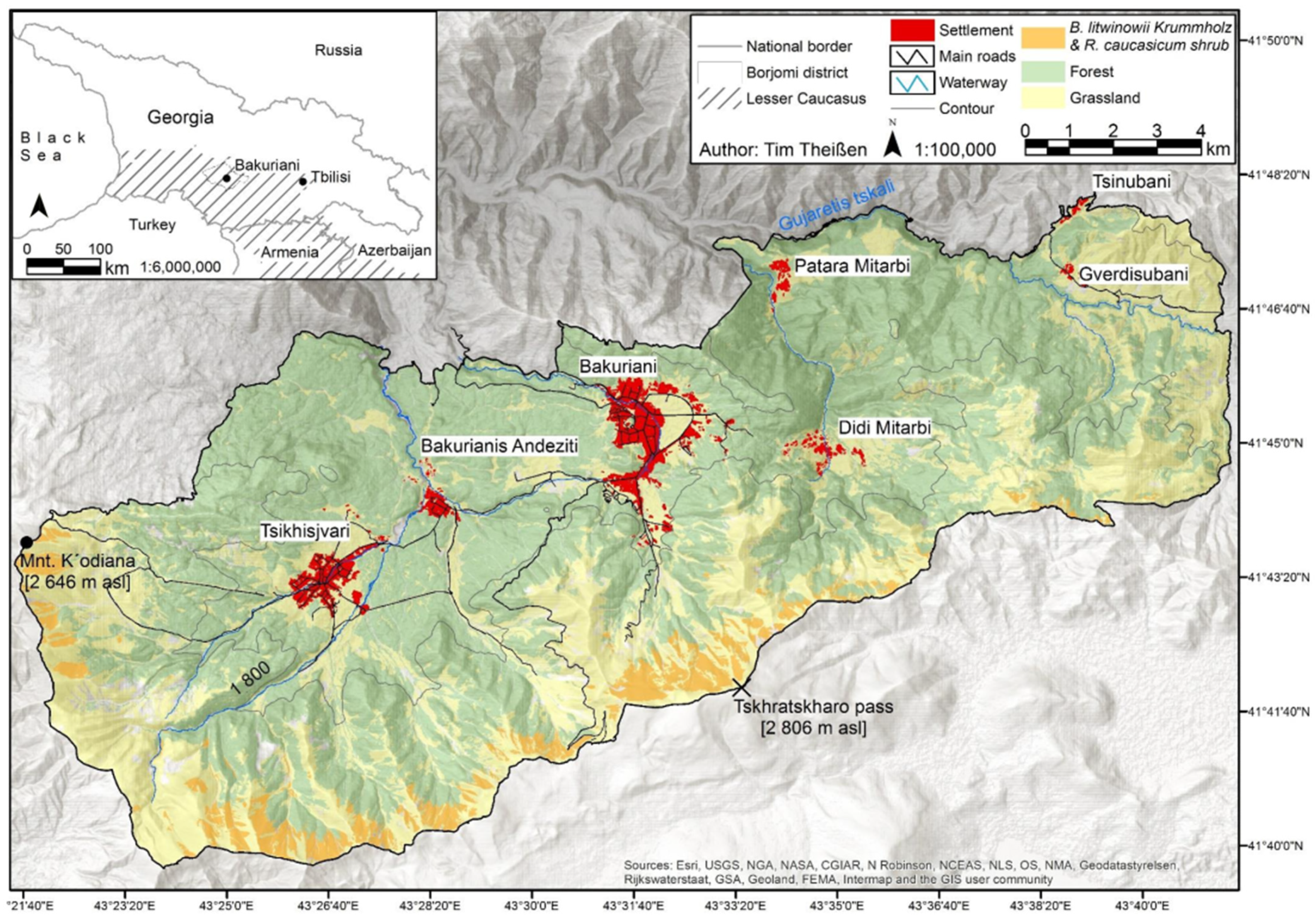
2.1. Geographical Location

This study was carried out in the Borjomi district (1189 km2), an administrative unit of the Samtskhe Javakheti region, located in the Lesser Caucasus of Georgia (Figure 1, inset map). Our study was focused on the land cover and land use of the Trialeti Range (southeastern part of the Borjomi district), covering an area from the middle-montane belt (1144 m a.s.l.) to the alpine belt (2826 m a.s.l.). The study area included the surrounding land of the settlements Bakuriani (1661 m a.s.l., with a population of 1985 in the year 2002), Bakurianis Andeziti (1600 m a.s.l., 515), Tsikhisjvari (1650 m a.s.l., 644), Didi Mitarbi (1300 m a.s.l., 48), Patara Mitarbi (1540 m a.s.l., 64), Gverdisubani (1550 m a.s.l., 34) and Tsinubani (1530 m a.s.l., no population data available) [26] (Figure 1).
All settlements are located in the upper-montane belt. Nearly all settlements are located within island-like clearings of mixed montane forests, except Didi Mitarbi, which is spread over several hilltops, and Gverdisubani, which is located on an almost forest-free macroslope. Most inhabitants of Gverdisubani (34), leave their homes in the winter to live in towns and cities, e.g., Tbilisi [27]. Nevertheless, most of them practice agriculture locally, also livestock breeding, since they can keep their livestock at neighboring villages during winter times. The study area border was set by available aerial images, altitude and land-use activity, i.e., accessibility.

2.2. Climate, Geology and Soil

According to the Köppen-Geiger climate classification system, the climate of the Tsikhisjvari-Bakuriani basin is warm summer humid continental, which is influenced by the Mediterranean Western Georgia (Colchis) and by the continental and moderately humid Javakheti Plateau in the south-east. The latter influence is the dominating one due to the humidity-losing eastward drifting air masses form the Black Sea which pass by several mountain ranges [28]. The mean annual temperature in Bakuriani is 4.6 °C and the annual precipitation is 800 mm [29]. The warmest month is August and February is the coldest, with a maximum rainfall in May and June and a minimum at the highest temperature in August. On average, 116 days are frost-free, around 100 days are above +10 °C, with 170 rainy days [28].
Extensive development of volcanic flysch sediments produced by uplift, deformation and erosion of mountains, characterize the main parts of the Lesser Caucasus [30]. The study area is part of the Trialeti mountain range, with Tskhratskharo Pass (2806 m a.s.l., Figure 1) centrally located at the south-east border of the study area. The range is the north-west border of the Javakheti volcanic plateau which includes many extinct volcanoes and dominates the Lesser Caucasus [31]. Paleocenic and Eocenic volcanic layers compose the topography of the study area. Here, mainly Umbric Leptosols, Eutric and Dystric Cambisols dominate [32]. According to the Russian classification, these soils are Brown Forest soils and Mountain Meadow soils [28].

2.3. Land Use in the Tsikhisjvari-Bakuriani Basin

The altitude in the study area comprises four altitudinal belts: the middle-montane belt, from 1144 to 1500 m a.s.l.; the upper-montane belt, from 1500 to 1800 m a.s.l.; the subalpine belt from 1800 to 2400 m a.s.l.; and the alpine belt from 2400 to 2826 m a.s.l. The latter is located in a thin line along the north-facing and west-facing slopes of the ridges of the Tskhratskharo range in the south (being a part of the Trialeti range), and along the K’odiani range in the west (Figure 1). Overall, the alpine belt covers 12 km2 (5%) of the whole study region. The main part is in the subalpine and the montane belt with 103 km2 (45%) and 108 km2 (50%), respectively.
The study area is richly forested; forest and woody plants cover 144 km2 (63%). Open landscape covers 85 km2. On the one hand, the openness is natural, especially in higher altitudes, with the natural grassland in the subalpine and alpine belts. On the other hand, the open landscapes in the lower altitude are anthropogenic openings for settlement-, infrastructure- and agricultural purposes. Additionally, the forested area is artificially opened in the cases of rolling uplands, debris flow activities, wildfire or windthrow, typical for mountainous regions. As, in the west, the study area is connected to the Banishevi region and, in the east, to the Javakheti region, the vegetation is enriched by Colchis-vegetation and by xeric vegetation of mountain-Armenia [28].
The major sources of income in the Borjomi district are agriculture, tourism and forestry [33]. Agriculture is dominated by livestock production. Cattle and sheep breeding are common [34]. Especially in the high-mountains, most of the agricultural production is managed in family holdings and for self-supply, due to low-productivity and land fragmentation [11]. A population survey (2011) within the framework of the ‘amies-project’, and based on a standardized questionnaire, showed almost every second household in the study region reared livestock and more than 40% of the surveyed households kept one to five cows [35]. In a subsistence herding system, the families’ cattle are collectively brought outside the villages by herdsmen in the morning after the milking process [36]. In terms of a rotated grazing system, the herdsmen flock to different locations around the settlement throughout the season in order to uniformly distribute the grazing pressure on common pastures of the villages. In the evening, the cattle move homewards independently or are managed by the herdsmen again [37].
Concerning the livelihood in the Borjomi district, tourism has become a significant source of income for the local population with an increasing number of hotels, lodging facilities and visitors [33]. Small-scale and community-based mountain adventure tourism is the most frequent form in Georgia (alpine skiing, discovery tours, eco-tourism, mountaineering, trekking and mountain-biking) [38]. However, and despite the fact that the Borjomi district is a traditional resort area, the hotels and guesthouses are often managed independently, i.e., without co-operation, not even to local tourism [39].
For the local population, the forest plays a significant role, not only for the provision of touristic services, such as recreation or aesthetic values. Using the forests for firewood collection and for agricultural, silvopastoral systems has a long history in the Caucasus [40]. In Georgia, woodland grazing is still widespread nowadays (Plachter and Hampicke, 2010) [36]. This traditional and rare land-use type provides a high biodiversity, since a diverse vegetation combines light-demanding and shade-tolerant species from grassland and forest habitats in continuous transition [41]. Javakhishvili (1949) [28] reported that, in the Bakuriani region, ‘postforest’ grassland was used by the local population as meadow or pasture throughout the middle of the 20th century, harvesting 60–70% of the whole hay biomass. In consequence of timber logging and the following forest grazing or haymaking, a well-developed grass and herbage layer in the understory established in the ‘postforest’ meadow and pasture sites. Flat or gentle slopes of former pine stands with mesophilic site conditions have been the most productive ‘postforest’ grassland [28].

2.4. Agriculture and Forestry during and after the Soviet Period

In the context of the region’s land-use development, the intensity of land use has varied since the last century until today in the Borjomi district. During the Soviet era the Caucasian states (Armenia, Azerbaijan, Georgia and Russia) established an extensive livestock transhumance system with subalpine and alpine summer pastures in the Greater and Lesser Caucasus mountains and winter pastures in the bordering plains [37]. The livestock production in the Soviet Union was intensified starting in the mid 20th century with increasing sheep and cattle stocking rates, up to several million heads in total, followed by pasture depression and local erosion as well, in consequence of the increased grazing pressure [15,42]. During that time, the agricultural production was partly practiced with disregard for the environment [38].
After the official declaration of independence from the Soviet Union in April 1991 [43], the borders to the neighboring states in the Caucasus were closed and thus the transhumance system was minimized significantly, with a loss of winter pastures and decreasing numbers of livestock. Furthermore, after the independence the young republic faced a period of internal conflicts [44] as well as political, economic and social restructuring [45]. In the 1990s, several agricultural structural reforms entered into force, e.g., the Law of Privatization of Agricultural Land (1993) and the Land Registration Law (1996) [46]. For instance, a decree permitted a maximum of 1.25 ha of the former state-owned land free for cultivation per homestead in rural regions [47]. However, especially in rural regions the decentralization of economic management and use of product markets rather than planning [48] resulted in disadvantages for its economic development, reflected in a lower living standard compared to urban centers in the country [49]. Loss of sales markets, distribution systems (including high quality seeds, concentrated feed, fertilizers and pesticides) and machinery after the breakdown forced a restructuring and retraction of agriculture production, especially in marginal regions in the mountains with frequently inadequate infrastructure [47]. In addition, differences in agro-climatic conditions plus the dominated small-sized farm structure led to regional differences in agricultural production, and thus in the income of the farmsteads, today, as described above, mostly operated in family holdings [47,50]. After 1989, the population in the Borjomi district strongly decreased, as in other rural areas of Georgia (Population Census, 2002) [50,51].
Tending, protection, restoration, and usage of the National Forest Fund are formalized in the Georgian Forest Code. Regional offices of forestry on a district level are responsible for the forest, which, nationwide, is almost completely publicly owned [27]. The use of the forest by the local population, except for free agricultural use, is managed by short-term or long-term licenses, confirmed by a ten-year management plan, developed by the State Forest Fund Cadaster. Mowing, pastoralism as well as the establishment of arable land within the forest are permitted. In terms of extent transhumance systems, the local population is given priority in agricultural use of the forest [52]. After Georgia’s independence, wood import from Russia almost stopped completely, with the consequence of increased unsustainable and uncontrolled harvesting of national timber resources [44]. Almost 60% of the annual forest harvest in 2005 was for fuelwood, primarily for rural households, additionally affected by the decreased energy subsidies for fossil fuels. Coppice forests have been most affected [27]. In 2009, agricultural farms and communities managed 20 percent of Georgia’s forested land [50].

3. Material and Methods

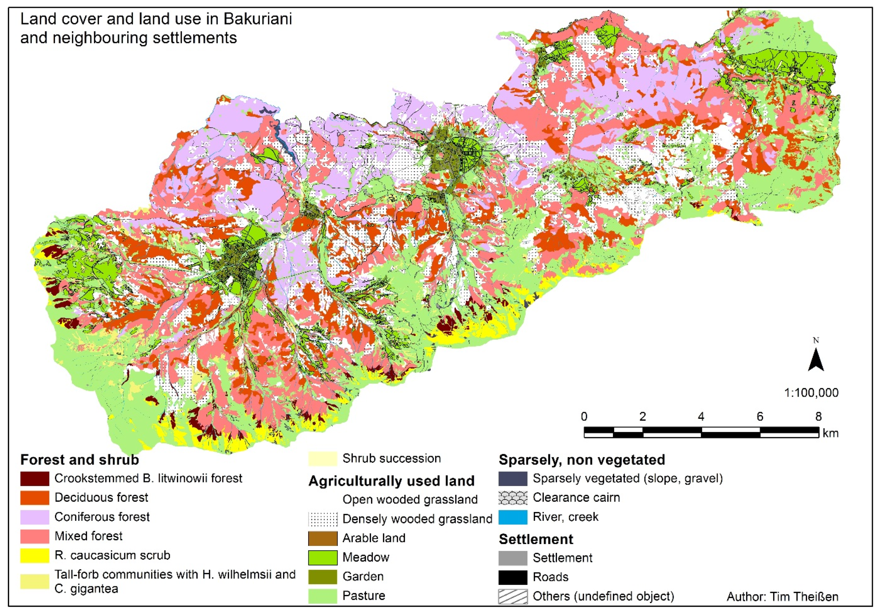
3.1. Land-Cover and Land Use Mapping

The land cover and land use (LCLU) of the study area was mapped in two steps: first, in an aerial image digitalization and classification and second in an on-site evaluation of the classified map in the field.
Official spatial and ortho-rectified aerial images in high resolution (cell-size 0.5 × 0.5 m) of 2006 and 2007 from the Borjomi district were interpreted via object-based classification. The interpretation was performed by a consistent hierarchical classification, primarily at a working scale of 1:5000, resulting in a cartographical visualization of the study region’s land use and habitat pattern [53]. Concerning the forest structure, visual homogeneous canopies were combined to separate coniferous, deciduous, and mixed forest stands and were distinguished in three cover ratios: closed forest with total canopy cover, dense forest with a canopy cover of 30–75%, and open forest with 10–30% cover. In this process, the wooded meadows and pastures were localized. We assumed that closed forests were negligible as areas used for grazing livestock. Areas with single trees or groups of trees with a canopy cover ratio less than ten percent were not treated as forests. Furthermore, we assumed that infrastructure, including roads and paths, and rivers are fragmenting polygons, whereas ditches are not.
During a one-month field work in 2012, the LCLU map was updated and evaluated with a focus on the villages’ agricultural land use and on the forest classes. The small-sized farmstead’s arable fields were localized and mapped beside the mowed gardens and orchards. Uncertain aerial image grassland classifications were inspected and primarily identified as meadow or pasture. In terms of the wooded meadows and pastures, the cover ratio was evaluated, and the dominant tree species determined. Concerning the closed forest, selected forest polygons of the map were inspected, and the dominant tree species were determined as well. Ten percent of the study area’s closed forest was evaluated, and these identified polygons were further used as reference data to re-determine the whole forest again. This last step was applied to object-based aerial image classification again to assign all forest polygons to specific forest classes, based on the field work’s dominant tree species identification.

3.2. Data Processing

An essential aspect of the study’s analysis was to differentiate the study area according to descriptive spatial indicators. Afterwards and by an argumentum e contrario, this classification served as a descriptor of the local land use and the highly structured and diverse forest pattern. The explanatory variables for the analysis were elevation, aspect, slope and distance to a settlement. We used a simple linear regression to calculate the R2 between the selected variables. However, with the strongest R2 of 0.33 between elevation and distance to settlement, the variables do not show a collinearity. Despite the topographical variables, distances to settlements were selected to explain the anthropogenic influence, assuming long distances define less influence (i.e., pronounced naturalness), respectively. The variables were derived from a 20 × 20-m resolution digital elevation model (DEM).
The DEM included the grid-cell information elevation and was further the basic data for the calculation of the other variables in the same resolution. Applying the raster calculation of ESRI’s ArcGIS© the inclinations in degree have been calculated. To include aspect in the analysis as a continuous rather than a categorical variable, the Eastness and Northness were calculated for each grid-cell. Both parameters range from −1 to 1. Values close to 1 represent the aspect east, and north, respectively. −1 reflect western and southern aspects. Both parameters can be calculated by trigonometric functions [54], for Eastness the sinus transform of the product of aspect and pi, and for Northness the cosine transform of the same term, both via applying the raster calculator. The distances to settlements have been calculated with the Network Analyst toolbox of ArcGIS© for the vector-level and based on the study area’s infrastructure. Further, and after the transformation into grid-cells, the Euclidean distance of each cell to the neighboring road or path has been determined. The sum of both, infrastructure length and distance to infrastructure was the distance of each grid-cell to a center-midpoint in the settlements. Finally, for 572,320 grid-cells we extracted and calculated the explanatory variables to cover the whole study area. This information was further combined in a vector-point-layer. The layer-points served as input data in the follow-up cluster analysis, treated as cases there.

3.3. Data Analysis

In this study, we applied the k-Means cluster analysis, combined with a previous v-fold cross validation. During the clustering algorithm, the involved cases were grouped together or separated from each other by distances between them. Therefore, the Euclidean distance has been set, operating as a geometric distance in a multidimensional space, while the variables are reflecting the dimensions of the space (here, Euclidean distance as a statistical measure in the statistic software, not the one calculated in GIS, which is used as an explanatory variable in the analysis). For the analysis, the included variables were standardized to exclude scale effects, in terms of variations in value scattering [55].
The prior v-fold cross validation is a calculation to find a suitable number of clusters by a defined data, the whole dataset in our case. The dataset was randomly portioned into ten parts, of which nine parts were used as training samples and one as a testing sample. The clustering algorithm computes the cluster with the training samples; the testing sample validates the cluster calculation by assigning the test samples to the built-up clusters. This is repeated ten times, every time with different testing samples. Finally, an averaged classification error is calculated. This whole procedure is carried out starting with two clusters, up to 25. To find the accurate number of clusters, not only the smallest averaged classification error is taken into account, also low cluster numbers are preferred (Sherrod, 2014). In the following k-Means clustering the number of clusters defined by the v-fold cross validation had been set. Then, all cases of the dataset were assigned to the clusters by the clustering algorithm. During this classification, the similarity within the cluster will be maximized and minimized between the clusters. Cases are repeatedly changed between the clusters in order to receive the most significant differences between the clusters. This is corresponding to an ‘ANOVA in reverse’ [56].

4. Results

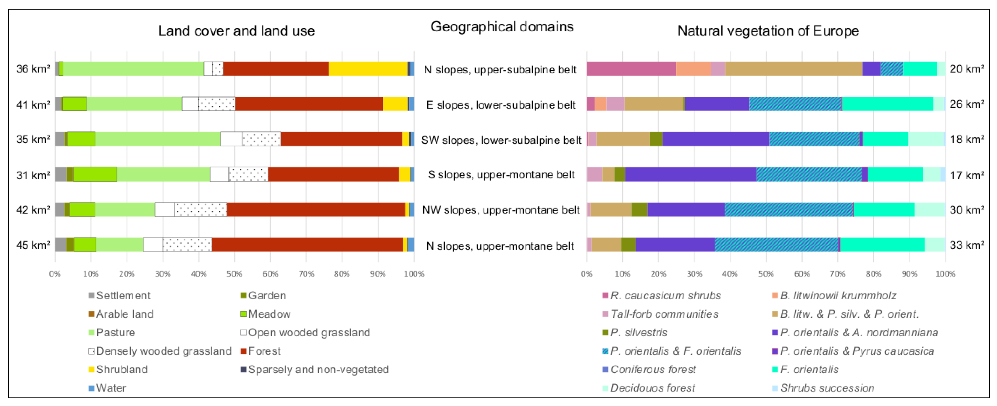
4.1. Quantification of the Local Land-Use Pattern

The output of the object-based classification of ortho-rectified aerial images (2006–2007) and the field evaluation in 2012 was a land-use and land-cover map of 2012 for Bakuriani and its neighboring villages (Figure 2).
The urban area of all six settlements and the local infrastructure cover 800 ha, 3.5% of the study area. Small-sized cultivated arable fields (22 ha, 0.1%) are mostly within the settlements, situated in house-gardens or orchards (239 ha, 1%). However, the fieldwork demonstrated that fenced cultivated parcels, sparsely located and arranged as allotments, are outside but near the villages. Infrastructure alone, including roads, paths, and trails cover 347 ha (1.5%) and are distributed all over the study area, connecting the settlements with peripheral agricultural areas but are also used by tourists for mountaineering, hiking and horse trekking.
Typical for mountainous regions, agriculture is dominated by grassland management for livestock farming, as is the case in the Bakuriani study area. The total open grassland is used as pasture (5787 ha, 25%) and meadow (1531 ha, 7%). Above the timberline, in the subalpine and alpine belt, natural open grassland provides additional pasture area for the local livestock and serves as upland pastures for flocks of sheep from nationwide nomadic pastoralists.
Most of the study area is covered by closed forest (9505 ha, 42%). Caucasian deciduous, coniferous and mixed forests make up the forest belt from the montane to the subalpine belt. The timberline and the tree line are mostly formed by the birch species Betula litwinowii, whereas the trees are in a crookstemmed, ‘krummholz’ habit in the upper timberline. The forest is used by the local population for forestry and agricultural purposes. Small-scale and mostly private timber logging is practiced for fuel wood and constructional timber. As mentioned above, a particular and remarkable characteristic of this region are the wooded grassland locations. According to the local agriculture, the local forest is strongly affected by agro-silvopastoral use (agroforestry). Forests are grazed by the local cattle throughout warmer periods and in the late summer, and parts of the wooded grassland are mowed. We classified these species-rich habitats as open wooded grassland (1117 ha, 5%) and dense wooded grassland (2471 ha, 11%), according to the tree layer cover.
Shrub vegetation covered 1325 ha (6%) of the total area and was classified as Rhododendron caucasicum shrub, tall-forb communities (dominated by Heracleum wilhelmsii and Cephalaria gigantea) and shrub succession.
Further landscape structure elements were defined as clearance cairn and sparsely vegetated areas (93 ha, 1%). The latter are bare soils, erosion sites, avalanche tracks, scree slopes, gravel, rock fissures, outcropping bedrocks and riverbeds. These natural elements were distinctive landmarks, typical for a high mountain landscape, and sparsely but entirely spread. Rivers, ditches and lakes covered 265 ha, 1%.

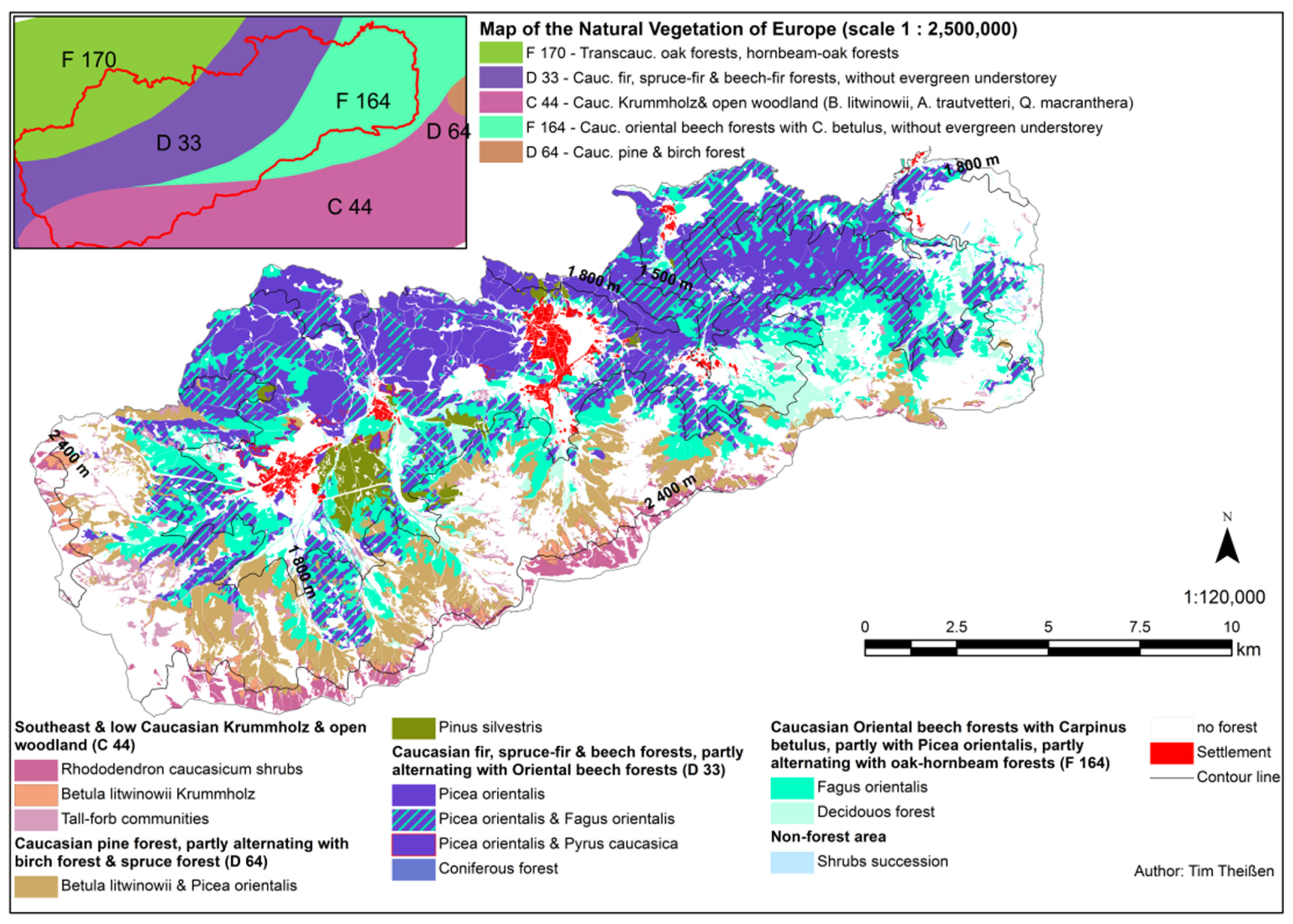
4.2. Interpretation and Quantification of the Local Forest

Forest, shrubs and wooded grassland covered together 144 km2 of the study region, i.e., 63% of the total study area. Comparing the compiled and evaluated forest map with the Map of the Natural Vegetation of Europe of the German federal office ‘Bundesamt für Naturschutz’, (freely available in the scale of 1: 2,500,000) a high accordance is revealed. The distribution of dominant tree species in the study region (Figure 3) corresponds strongly with the distribution of the BfN-mapping units (inset map of Figure 3).
This suggests that the local forests exist in a near natural composition, in the sense of the BfN-map. According to this potential natural vegetation map, the study region is subdivided in four forest types:
-
Caucasian fir, spruce-fir and beech-fir forests (Abies nordmanniana, Picea orientalis, Fagus sylvatica subsp. orientalis) without evergreen understorey, partly alternating with Oriental beech forests (Fagus sylvatica subsp. orientalis) (BfN-mapping unit D 33).
-
Transcaucasian oak forests (Quercus iberica), hornbeam-oak forests (Quercus iberica, Carpinus betulus) and Oriental hornbeam-oak forests (Quercus iberica, Carpinus orientalis), with Acer cappadocicum, Sorbus torminalis, partly in combination with shibliak communities (scrub) (F 170).
-
Caucasian Oriental beech forests (Fagus sylvatica subsp. orientalis) with Carpinus betulus, partly with Picea orientalis, without evergreen understorey, partly alternating with oak-hornbeam forests (Carpinus betulus, Quercus iberica) (F 164).
-
Southeast and Low Caucasian krummholz and open woodlands (Betula litwinowii, Acer trautvetteri, Quercus macranthera), scrub (Rhododendron caucasicum), tall-forb communities (Heracleum sosnowskyi, Aconitum orientale) and grasslands (Festuca woronowii, Calamagrostis arundinacea, Geranium ibericum) (C 44).
However, the field work in 2012 revealed two mismatches of the current status of the local forest and the potential vegetation map: first, the distribution of the Transcaucasian oak forests (BfN-mapping unit F 170) in the north-west of the study region was considerably reduced. The reduction of this strongly xerophytic oak forests is the consequence of long-standing effects of anthropogenic impact [57]. In our opinion, these forests are replaced by oriental beech forests, spruce forests and mixed spruce-beech forests. Second, an increase in the extent of mixed pine, spruce and birch forest can be described within the study region, on the north-facing slopes leading up to the Tskhratskharo Pass. These forests can be described as:
-
Caucasian pine forests (Pinus kochiana), partly alternating with birch forests (Betula litwinowii, B. raddeana) and spruce forests (Picea orientalis) (mapping unit D 64).
These forests also belong to the mesophytic and hygromesophytic Caucasian coniferous and mixed broad-leaved-coniferous forests such as the spruce and spruce-beech forests.
Comparing the forest types, 7136 ha (31% of the total study area) were covered by mapping unit D 33, whereas the fieldwork revealed that spruce is more frequent than fir in the study area. F 164 covered 3429 ha (15%). The Unit C 44 covered 1258 ha (6%) and D 64 2532 ha (11%). Considering the altitude in the forest pattern, 80% of the coniferous forest existed in the middle-montane and upper-montane belt, i.e., lower than 1800 m a.s.l. The mixed forests and broad-leafed forests were mainly located above, in the subalpine belt. Here, in the lower-subalpine belt, the lower boundary of the timberline occurred, partly formed by Fagus orientalis forest, preferring north-western slopes. In places, the Betula litwinowii and Picea orientalis forest made up the upper boundary of the timberline, for example on the exposed northern slopes leading up to the Tskhratskharo Pass. Betula litwinowii krummholz formed the tree line in the study area on northern slopes. Nearly the whole shrub vegetation (90%) occurred above 1800 m a.s.l., consisting of Rhododendron caucasicum shrub, Tall-forb communities and shrub succession. The endemic R. caucasicum shrub grows in the natural grassland above 2400 m a.s.l. in the alpine belt.

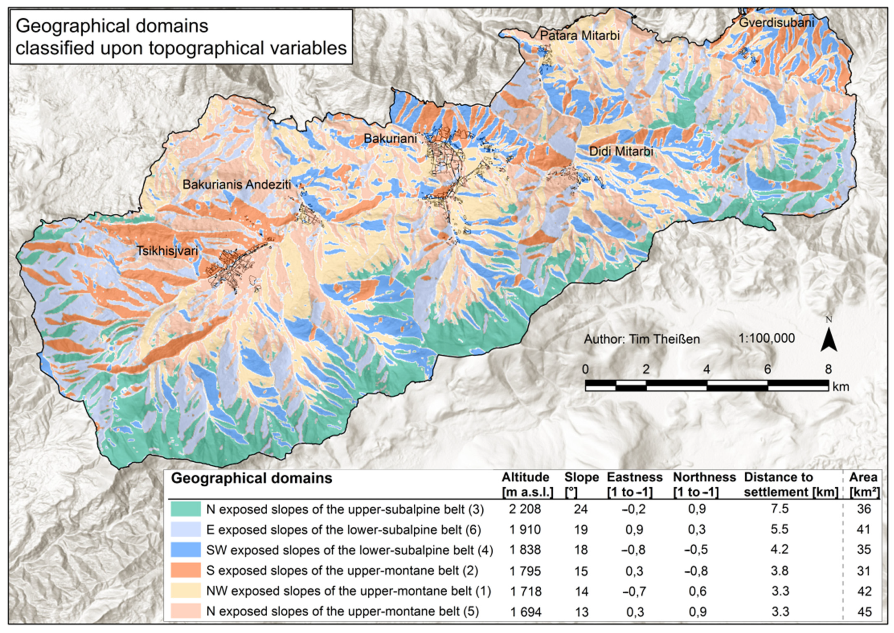
4.3. Landscape Classification along Topography

The k-Means clustering landscape analysis calculates six clusters with a classification error of 0.315 for the testing sample. The classification error of seven clusters is even smaller (0.300). However, the decline of the error from six to seven clusters is smaller than the decline from five to six. Thus, at six clusters the classification error curve has been saturated and the cluster numbers been set, including the fact that a lower cluster number is desirable.
The output of the analysis is a classification of the study region in six classes (domains) according to explanatory variables as spatial indicators (see Section 3.3). The classification is relatively homogeneous due to the spatial expansion of the domains (minimum 13%, 31 km2 of the study area, maximum 20%, 45 km2). Aspect (Northness and Eastness) was the variable with strong differentiation of the domains (Figure 4).
The total study area reaches from the montane (minimum 1144 m a.s.l.) to the alpine belt (maximum 2826 m a.s.l.). According to the altitudinal belts, three geographical domains cover the upper-montane belt, north exposed slopes showed the lowest altitude (a mean of 1694 m a.s.l.) and the flattest terrain (mean = 13°) of the study area. This domain is close to the settlements (with a mean distance of 3.3 km). NW exposed slopes of this belt showed a marginally higher altitude, with a mean of 1718 m a.s.l. and 14° steepness, but the same proximity to settlements as the first domain. South exposed slopes, with 1795 m a.s.l., reach the border to the subalpine belt. These slopes are on average 15° steep, with 3.5 km distance to villages. With a higher altitude the steepness and the distance to the settlements are increasing. This is true for the three domains in the subalpine belt. South-west exposed slopes of the lower-subalpine are at 1838 m with 18° inclination and 4.2 km distance. East exposed slopes here reach 1910 m, 19° and 5.5 km. Finally, in the upper-subalpine, where north-exposed slopes dominate, the area is on average 2208 m a.s.l., the slopes are 24° steep and the next settlement is 7.5 km away. These slopes belong to the macroslopes of the Trialeti range, located in the south, and are the highest locations of the study area.
Further the output of the cluster analysis served as a grouping variable for an analysis of the pattern of land use and of forest habitats (Figure 5).
Settlements show a strong distribution on relatively flat northern slopes in the upper-montane belt. Thus, also gardens, orchards and arable land are mainly in this domain. Open grassland is less distributed. In contrast, open and dense wooded grassland are most frequently spread in this domain. As the forest consists mostly of P. orientalis with A. nordmanniana and P. orientalis with F. orientalis here (both mapping unit D 33), the wooded grassland is characterized by these species as well. However, the conifers dominate in densely wooded grassland, and the broad-leafed trees in the open wooded grassland. F. orientalis and B. litwinowii are spread here as well, but to a minor extent (F 164 and C 44).
At the NW exposed slopes, there are less settlements and forests. The open landscape, i.e., meadow and pasture grassland, increases slightly. The forest distribution is quite equal to the N domain. However, B. litwinowii and P. sylvatica are more frequent here and the open wooded grassland consisted of more conifers.
At the S exposed slopes, we found the most open landscape of the montane belt, i.e., grassland habitats. Compared to the northern exposed slopes, the shrub amount is also higher on southern slopes. Of the 17 km2 south exposed montane forests, the coniferous species P. orientalis and A. nordmanniana are dominant. Additionally, we found the species Pyrus caucasica quite frequently, here. F. orientalis and deciduous forest exist to a clearly lesser extent. The shrubs consisted primarily of tall-forb communities.
On SW exposed slopes of the lower-subalpine belt grassland is dominant as well, but with a lesser amount of meadows, since the distance to the settlements and the inclination increase. Overall, settlement areas in the subalpine belt decrease. Furthermore, with increasing altitude, the forest pattern changes: P. orientalis with A. nordmanniana decreased, whereas B. litwinowii and Pinus slivatica increased. P. orientalis also belongs to this formation but with increasing altitude less frequently than beech and pine. As is the case in the NW domain of the montane belt, the wooded grassland consisted mostly of the conifers and the open of broad-leafed trees.
In the domain ‘E slopes of the lower-subalpine belt’, which covers, in total, more area than the ‘SW exposed slopes of the lower-subalpine’, the proportion of meadow and pasture habitats are less, whereas forest and shrub land increased. In the forest, the amount of F. orientalis increases strongly. On these slopes as well, birch and pine were more frequent. Accordingly, as F. orientalis is dominating, the wooded grassland consisted mostly of beech. However, both types, dense and open, were also found in the formation B. litwinowii and P. silvestris with partly P. orientalis. In the shrub land, we found a succession of shrubbery and the first R. caucasicum individuals. Besides and sparsely spread, crookstemmed B. litwinowii were located here.
In the highest domain of the study area, the ‘N slopes of the upper-subalpine belt’, we found subalpine and alpine pastures and meadows, with less occurrence of the latter. However, in this domain with the least forest, the mentioned birch, pine and spruce formation is predominant, followed by pure beech forest. Dense and open wooded grasslands were located in these forests. On these northern slopes of the upper-subalpine belt the crookstemmed birch was most widely spread. In contrast to the least existent forest, this domain showed the most amount of shrub land, made up of R. caucasicum and tall-forb communities. According to our data set, the timberline in the study area ran at 2054 m a.s.l. with a deviation of ±147 m, and a maximum at 2517 m a.s.l. This timberline was mostly formed by the dense mixed forest of B. litwinowii, P. silvestris and P. orientalis. Furthermore, the treeline, which was formed by the crookstemmed birch, showed a mean of 2324 m a.s.l., with a deviation of ±124 m and a maximum at 2606 m a.s.l.

5. Discussion

5.1. Land-Use Distribution

The Caucasus Mountains are characterized by natural contrasts with strong topographical gradients. Changeful geographical and climate conditions strongly influence the land cover and vegetation pattern [58]. There is a distinct horizontal and vertical vegetation structure in Caucasia, depending on both temperature and moisture distribution [59]. Besides these physical features, the land cover in Europe’s mountains is affected by the activities of the people living in the mountains, establishing a cultural landscape which, in the past, was made up of traditional mountain farming [60]. Since the 1970s, traditional management of the mountainous cultural landscape became more and more abandoned in Central and Western Europe, due to the preference and intensification of productive farmland and under-utilization of less productive or hard to access locations [61]. However, in the former Soviet states of Eastern Europe, the agricultural production shifted from a collectively and centrally planned to a market oriented and price liberalized economy as of the 1990s, after the demise of the Soviet Union. This economic transition further faced post-socialist land reform strategies and rural population outmigration [22]. In mountainous regions, this led to farmland abandonment and subsequent land-cover changes as consequences [62,63]. Still, the Lesser Caucasian land-cover and land-use pattern is quite similar to other mountainous regions of Europe, with dominating forest followed by grassland, cultivated and barren land [60]. In 2012, most of the land-use activity in the study area was concentrated in Bakuriani and Tsikhisjvari, the largest settlements. Since most of the hotels and guesthouses are located in Bakuriani, touristic activity is focused here. In comparison, agricultural production dominated in the western part, in and around Tsikhisjvari, considering the area of meadow, garden, orchard, arable land, and scattered orchard meadows with Pyrus caucasica (Figure 2 and Figure 3, Section 4.1). Along with a high number of uninhabited houses and ruins, we localized less grassland and home-gardening management in the remote settlements of Bakurianis Andeziti, Didi Mitarbi, Patara Mitarbi and the Gverdisubani villages. This is in accord with Kohler et al. (2017) [64], who described the strongest population decrease, even total settlement abandonment, after 1989 in remote settlements as well (e.g., in the Oni district in the central Greater Caucasus of Georgia). The field work showed that grassland and home gardening were managed in a traditional way, an extensive, low-input production mainly for self-supply. We found that the whole unfenced open grassland was used as pasture, with a decreasing grazing pressure with increasing distance to the settlements. The fenced meadows are cut once a year in August. Additionally, flocks of sheep from supra-regional nomadic pastoralists used the upper grasslands. Although the Borjomi district is rich in natural resources, such as forests, biodiversity-rich meadows and pastures as well as water, these ecosystems are vulnerable to degradation induced by mismanagement or illegal logging of timber [39].
Across the entire study area, we found wooded grassland of a dense or open type, used either as pasture or as meadow. Silvopastoral systems are one of the oldest land-use types in Europe, a prehistoric form that dates back to Neolithic times [65,66]. In Europe, the number of actually used wooded grassland decreased over the past century and can be found mainly in south and southeast of the continent, today [67]. The quantification of our data revealed that grazing in wooded grassland is dominating. Not surprisingly, and in accordance with the preference of a minimized workload, the fewer wooded meadows were mostly located near the settlements. The densely type occurred mostly in the upper-montane belt, whereas the open type existed in the lower subalpine. Thus, the amount of deciduous forest is higher in open wooded grassland, as this forest became dominant with increasing altitude. This ecotone (i.e., a dynamic mosaic of forest and grassland with continuous gradients which is not used intensively) is characterized by a high [68,69]. Furthermore, the uncontrolled use of wooded ecosystems in the study area, by unchecked cuttings and unregulated use of wooded pastures, is seen critical with presumed negative impacts on the forest ecosystem, such as the spreading of diseases and pests [33]. Nevertheless, in our opinion, uncontrolled and illegal timber logging negatively affects or even degrades the forest ecosystem stronger than the use of wooded grassland. Further, an ongoing, non-intensified use can be a valuable management tool to maintain or even increase biodiversity [70].

5.2. Forest Distribution

Most of the studied forest is covered by mesophytic and hygomesophytic Caucasian coniferous and mixed broad-leafed-coniferous forests (following the mapping unit D 33 of the Map of the Natural Vegetation of Europe). The spruce Picea orientalis and the beech Fagus orientalis are the dominant tree species, both also making up pure stands but to a lower extent than the mixture, and mainly by P. orientalis, which prefers deep to shallow soils that are coarse to fine-textured, with a broad range in nutrient availability [71]. The Caucasian fir, spruce-fir and beech-fir forests show a vertical distribution between 850 (1000) and 2000 m a.s.l., whereas the dominance of the spruce increases with increasing altitude [72]. The shade-tolerant spruce is the most widely spread coniferous species in the study area. It has a relatively broad temperature tolerance, is not vulnerable to winter frosts but late frosts in spring, and is susceptible to too much moisture [28]. The fir Abies nordmanniana is rarely found in the forests here, since it is more frequent in lower altitudes [41,73]. The Caucasian coniferous forests are quite different from those of Western Europe, where one can find more taiga (boreal) species, such as the larch, and even boreal species of spruce and fir [74].
The pine Pinus silvestris var. hamata (assigned to D 64) occurs in the study area but to minor extent than the spruce. This pine is described as a dry tolerant, light preferring and non-competitive tree [73]. It is a pioneer species which can develop quickly (e.g., on windthrow-sites, here it forms secondary pioneer woodland), also on nutrient-poor locations, but prefers open and flat places [28]. In the study region, as well as in the whole Caucasus, Pinus silvestris var. hamata-forests do not form a continuous altitude layer, they are distributed as islands [72]. According to Javakishvili (1949) [28] this pine is naturally distributed in the region, whereas on the Map of the Natural Vegetation of Europe this pine is naturally distributed on or directly at the Javakheti Plateau [20], i.e., south and east of the study area. However, this pine was planted around the settlements Bakuriani and Tsikhisjvari in the past, with the aim of harvesting the pine tree resin for paint manufacture.
Naturally, the oak occurs in the study area, but is strongly reduced. Oak forests are absent in the humid western parts of Georgia, but mesophilous forms occur in the Lesser Caucasus (such as mapping unit F 170), preferring north-exposed slopes [40]. In the study region, two oak species are rare. One is Quercus iberica, showing a potential altitude distribution from 1000–1700 m a.s.l. Above 1400 m a.s.l. it is replaced by the Caucasus endemic oak species Quercus macranthera. The oak never occurs in closed stands together with F. orientalis since the shade intolerant oak cannot compete with the oriental beech. This is unlike the sessile oak in Central Europe, which can stand the competition in closed stands with the beech. Even Quercus macranthera cannot compete and is therefore mostly replaced by the oriental beech as well or by the subalpine krummholz vegetation with increasing altitude [57]. Additionally, human impact strongly affected oak forests, especially in the study area, since favorable oak forest locations, which are base-rich cambisols and chromic luvisols, have been clear-cut for the purposes of agricultural land use [57]. This is why there is an urgent need to conserve the oak remnants in Caucasia, an issue that should be focused on with special attention [75].
The most widely spread broad-leaved species in the study area is the beech Fagus orientalis (in this study assigned to the mapping unit F 164). Beech forests occur in temperate climates with a continuously positive precipitation budget, while an oceanity or continentality gradient influences the regional classification of deciduous forests [71]. In the study area, the continental climate is pronounced due to the bordering Javahketi Plateau. For the region, it is described that soil and inclination are main factors for the distribution of the beech: soil moisture is important for the beech development, but persistently or periodically wet soils are unfavorable [71]; flat and windy terrain inhibit the tree development since frosts are damage the young beech shoots [28]. The upper limit of the beech depends on the temperature regime and the amount of precipitation during winter, since snow protects young trees from frost. When the climate conditions are more continental, the vertical limit of the beech is at 2200 m a.s.l. [74]. The beech prefers skeletal, moderately acidic to neutral cambisols, and when the canopy cover is open, beech forests represent a well-developed understorey rich in light-demanding gramineous and herbage plants [57]. On such openings, the re-growth of F. orientalis is strongly affected by browsing through forest grazing [28,41].
The low Caucasian krummholz and open woodlands (C 44) consist mainly of the birch Betula litwinowii, a Caucasian emdemic species. The krummholz-forests and open woodlands are a transition area between the downhill closed forests and the open alpine heaths, meadows and grasslands; and the open woodlands form the climatically determined tree line [40]. The vegetation is a mixture of typical subalpine and forest vegetation [41]. According to Javakhishvili (1949) [28] the upper limit of the timberline reached 1800–1900 m a.s.l. in the Bakuriani region, with open woodland above, thinning out at higher altitude; subalpine grassland formations began at 2000–2100 m a.s.l. up to the alpine belt at 2400 m a.s.l. Open woodlands mostly stock on cambisol, rarely on leptosol or rendzic leptosol, which is commonly covered by dwarf-scrub- and scrub-formations [40]. Box et al. (2000) [76] determined the tree line in the Bakuriani region at about 2300 m a.s.l.

5.3. Land-Use and Forest Pattern along Topographical Gradients

In order to characterize the spatial land use and vegetation pattern, we classified the study area with regard to its sub-areas (i.e., geographical domains). The strong topographical gradients (altitude, slope and aspect) in the study area provided relevant indicators for this spatial classification. It is appropriate to use topography in a mountain landscape typology, since the vegetation and land use pattern is strongly influenced by altitudinal zonal characteristics [77].
The montane belt, covering approx. 50% of the study area, is rich in forest, whereas coniferous species dominate. On northern and northwestern slopes of the montane belt, we found a dominance of mixed spruce-beech-forests, what is in accordance with the description of Matuszkiewiez (2004) [71]. The beech is a shade preferring tree with a local affinity to north exposed slopes. The oriental spruce stocks more or less on all aspects, but with a west slope affinity [73]. When the soils are moister the spruce can compete, even outcompete the pine on southern slopes. This is the case on southern slopes near the Bakuriani settlement, described by Javakhishvili (1949) [28], where P. orientalis is the dominant tree species nowadays after predominance of pine-stands before. Hübl et al. (2010) [41] suggested that the spruce might be supported by human impact. Around Bakuriani and Tsikhisjvari the wild form of a pomaceous tree Pyrus caucasica occurs. Additionally, fruit trees were planted near the settlements for fruit cultivation [73]. Most of the cultivated montane grassland is located near the settlements, i.e., in short distance and comparatively well accessible. On southern slopes, the amount is higher than on other expositions, since here there are favorable sun-exposed locations. However, shrub succession with tall-forb communities indicate the abandonment of former land-use activity and were found in the whole study area but mainly in the montane belt-a fact that underpins the decline of land-use activity in the study area.
In the subalpine belt, the patterns are different: with increasing altitude, the beech is replaced by the maple Acer trautvetteri and by the birch Betula litwinowii. This Caucasian birch has a clear affinity to higher altitude and northern aspects. In the study area, B. litwinowii predominantly makes up the treeline on northern slopes, together with Sorbus aucuparia, and with pine on the western slopes [73]. Land-use activity and distinct climatic conditions form the huge amount of open landscape in the subalpine belt. Each restrict forest establishment, or above the treeline even tree growth [78], and both co-form both the semi-natural and natural grassland.
The forest identification, which is based on dominance and combination-mosaic types, provided the possibility to classify the local forest and build the sound base for our forest-pattern evaluation. The comparison with the potential natural vegetation revealed a near-natural forest pattern. The naturalness of the vegetation, considered as a biological indicator, is an important ecological characteristic of a location that is used for various nature impact assessments [79]. However, a livestock farming system, as an impact on naturalness, provides a high biodiversity at multiple scales [36], and in the study area especially through the agricultural use of the forests. Agriculture and forestry are highly relevant for managing the landscape and the provision of ecosystem services, such as water purification, erosion control, habitat provision and carbon sequestration [80]. In accordance with Schlüter (2005) [79], we classified the studied forest as a near-natural, less-managed forest, with non-intensive pasture and meadow in near-natural grassland and wooded grassland. For the benefit of the multifunctionality of this cultural landscape it is vital to understand the current agriculture and forest resources, to foster a systematic approach for sustainable development that is able to mitigate and adapt threats such as rural poverty and global change [81,82].

6. Conclusions

The Bakuriani region in the Lesser Caucasus of Georgia provided a good opportunity to analyze traditionally managed land use and a near-natural forest. However, the mapping and quantification of the land use and land cover of the 223-km2 study area was time consuming and revealed certain difficulties, such as the exact determination of grassland management and forest-type classification or explicit differentiation among the types. The wide-spread wooded grasslands that represent the transition between agriculture and forestry-systematically and spatially-defined the major challenge for spatial-explicit GIS-based mapping. Nevertheless, our results indicate a great diversity of habitat types, whereby the mentioned wooded grassland plays a significant role in providing habitats for both light-demanding and shade-tolerant species. Further, the land-cover and land-use quantifications pointed out that shrub encroachment took place in the entire study area, indicating a decline in land use as a result of population outmigration. In our opinion, the studied forest is near natural and less managed, and demonstrated a high accordance with the potential natural vegetation (PNV). However, two differences to the PNV were localized: strongly reduced oak stands and an increased amount of pine. Both might be caused by anthropogenic influence in the past. Besides already existing studies about the current forest vegetation by, for example, Nakhutsrishvili (2013; 2006) [2,83], Hübl (2010) [41], and Box (2000) [76], further studies could emphasize the valuable biodiversity that is worth protecting of these Lesser Caucasian forests. Finally, the georeferenced and orthorectified dataset from plot to landscape level can be useful for planning tasks, monitoring systems and assessments. The combination of land-use information and land-cover composition make it especially valuable for ecological monitoring and nature conservation. In respect of the multifunctionality of this cultural landscape, the compiled GIS-maps can function as a sound base for sustainable management plans in forestry and agriculture. This study was made possible by two Georgian-German joint projects to analyze environmental and societal processes in mountainous regions and to foster sustainable development. The elaboration of methodological approaches in applied research was a focal point in these two linked projects. Regardless of the results, these methods, if modified and adapted, can help to analyze landscape structures in other mountain regions. However, another mountain landscape upholds other environmental and societal processes to be considered.

Author Contributions

For this research article T.T. did the fieldwork, geo-information-system work, data analysis and writing. The co-authors A.O. and R.W. initiated the study, planned the design and gave valuable comments to the paper. All authors have read and agreed to the published version of the manuscript.

Funding

This study contributes to the framework of the major project “Analyzing multiple interrelationships of environmental and societal processes in mountainous regions of Georgia (AMIES)”, funded by the Volkswagen Foundation.

Institutional Review Board Statement

Not applicable.

Informed Consent Statement

Not applicable.

Data Availability Statement

The aerial images for the land-use and forest-pattern maps were kindly provided by the Institute of Geography of the Ivane Javakishvili Tbilisi State University, TSU, in Tbilisi, Republic of Georgia.

Acknowledgments

We dedicate this article to George Nakhutsrishvili, Tbilisi Botanical Garden and Institute of Botany; Ilia State University, Kojori road 1, 0105, Tbilisi, Georgia, for his 90th anniversary. This investigation was carried out in the framework of amies–analyzing multiple interrelationships between environment and society, an international project that was funded by the Volkswagen Foundation (2009–2012). We are thankful to our Georgian and German project partners for valuable discussions during the project and who supported our study. In particular, we thank the Institut of Geography (Ivane Javakishvili Tbilisi State University, TSU) for providing the aerial images. Furthermore, we thank Anja Magiera and Wiebke Hansen for proof-reading the manuscript. Finally, we are grateful to the Volkswagen Foundation for financing the project.

Conflicts of Interest

The authors declare no conflict of interest.

References

  1. EU-FAO. Assessment of the Agriculture and Rural Development Sectors in the Eastern Partnership Countries; Georgia (No. FAO Project No. GCP/RER/041/EC); FAO Regional Office for Europe and Central Asia: Budapest, Hungary, 2013. [Google Scholar]
  2. Nakhutsrishvili, G. The Vegetation of Georgia (South Caucasus); Springer: Berlin/Heidelberg, Germany, 2013. [Google Scholar]
  3. Volodicheva, N. The Caucasus. In The Physical Geography of Northern Eurasia; Shahgedanova, M., Ed.; Oxford University Press: Oxford, UK; New York, NY, USA, 2002; pp. 350–376. [Google Scholar]
  4. Nagy, L.; Grabherr, G. The Biology of Alpine Habitats. In The Biology of Habitats Series; Oxford University Press: Oxford, UK; New York, NY, USA, 2009. [Google Scholar]
  5. Nakhutsrishvili, G. High Mountain Vegetation of the Caucasus Region. In Alpine Biodiversity in Europe; Nagy, L., Grabherr, G., Körner, C., Thompson, D.B.A.E., Eds.; Springer: Berlin/Heidelberg, Germany, 2003; pp. 93–103. [Google Scholar]
  6. Millennium Ecosystem Assessment. Ecosystems and Human Well-Being: Current State and Trends; Island Press: Washington, DC, USA, 2005; Volume 1. [Google Scholar]
  7. Krever, V.; Zazanashvili, N.; Jungius, H.; Williams, L.; Petelin, D. (Eds.) Biodiversity of the Caucasus Ecoregion: An Analysis of Biodiversity and Current Threats and Initlal Investment Portfolio; World Wide Fund for Nature: Baku, Azerbaijan, 2001. [Google Scholar]
  8. Mittermaier, R.A.; Myers, N.; Mittermeier, C. (Eds.) Hotspots: Earth’s Biologically Richest and Most Endangered Terrestrial Ecoregions, 1st ed.; CEMEX and Conservation International: Mexico City, Mexico, 1999. [Google Scholar]
  9. Myers, N.; Mittermeier, R.A.; Mittermeier, C.G.; Da Fonseca, G.A.; Kent, J. Biodiversity hotspots for conservation priorities. Nature 2000, 403, 853–858. [Google Scholar] [CrossRef] [PubMed]
  10. Zazanashvili, N.; Sanadiradze, G.; Bukhnikashvili, A. Caucasus. In Hotspots: Earth’s Biologically Richest and Most Endangered Terrestrial Ecoregions; Mittermaier, R.A., Meyers, P., Robles, G., Mittermeier, C.G., Eds.; Conservation International, CEMEX/Agrupacion Sierra Madre: Mexico City, Mexico, 1999; p. 432. [Google Scholar]
  11. Ministry of Agriculture. Rural Development Strategy of Georgia 2017–2020; Government of Georgia: Tbilisi, Georgia, 2016.
  12. Zazanashvili, N.; Mallon, D. (Eds.) Status and Protection of Globally Threatened Species in the Caucasus; Contour Ltd.: Tbilisi, Georgia, 2009. [Google Scholar]
  13. Galvánek, D.; Lepš, J. Changes of species richness pattern in mountain grasslands: Abandonment versus restoration. Biodivers. Conserv. 2008, 17, 3241–3253. [Google Scholar] [CrossRef]
  14. Akhalkatsi, M.; Ekhvaia, J.; Mosulishvili, M.; Nakhutsrishvili, G.; Abdaladze, O.; Batsatsashvili, K. Reasons and Processes Leading to the Erosion of Crop Genetic Diversity in Mountainous Regions of Georgia. Mt. Res. Dev. 2010, 30, 304–310. [Google Scholar] [CrossRef]
  15. Nakhutsrishvili, G.; Akhalkatsi, M.; Abdaladze, O. Main threats to mountain biodiversity in Georgia. In Mountain Forum Bulletin; Mountain Forum Secretariat, Ed.; 2009; pp. 18–19. Available online: https://www.researchgate.net/publication/234836466_Main_Threats_to_Mountain_Biodiversity_in_Georgia (accessed on 8 May 2022).
  16. Kohler, T.; Giger, M.; Hurni, H.; Ott, C.; Wiesmann, U.; Wymann von Dach, S.; Maselli, D. Mountains and Climate Change: A Global Concern. Mt. Res. Dev. 2010, 30, 53–55. [Google Scholar] [CrossRef] [Green Version]
  17. Kohler, T.; Maselli, D. Mountains and Climate Change: From Understanding to Action; CDE: Bern, Switzerland, 2009. [Google Scholar]
  18. Briner, S.; Elkin, C.; Huber, R.; Grêt-Regamey, A. Assessing the impacts of economic and climate changes on land-use in mountain regions: A spatial dynamic modeling approach. Agric. Ecosyst. Environ. 2012, 149, 50–63. [Google Scholar] [CrossRef]
  19. Gentle, P.; Maraseni, T.N. Climate change, poverty and livelihoods: Adaptation practices by rural mountain communities in Nepal. Environ. Sci. Policy 2012, 21, 24–34. [Google Scholar] [CrossRef]
  20. Bohn, U.; Neuhäusl, R.; Gollub, G.; Hettwer, C.; Neuhäuslová, Z.; Schlüter, H.; Weber, H. Karte der Natürlichen Vegetation Europas/Map of the Natural Vegetation of Europe, Explanatory Text, 1st ed.; Landwirtschaftsverlag: Münster, Germany, 2004. [Google Scholar]
  21. Horvat, I.; Glavač, V.; Ellenberg, H. Vegetation Südosteuropas-Vegetation of Southeast-Europe, Geobotanica Selecta; G. Fischer: Stuttgart, Germany, 1974. [Google Scholar]
  22. Kuemmerle, T.; Hostert, P.; Radeloff, V.C.; van der Linden, S.; Perzanowski, K.; Kruhlov, I. Cross-border Comparison of Post-socialist Farmland Abandonment in the Carpathians. Ecosystems 2008, 11, 614–628. [Google Scholar] [CrossRef]
  23. Heinimann, A.; Breu, T.; Kohler, T. The Challenge of Applying Geographic Information Systems to Sustainable Mountain Development. Mt. Res. Dev. 2003, 23, 312–319. [Google Scholar] [CrossRef] [Green Version]
  24. Pecher, C.; Tasser, E.; Walde, J.; Tappeiner, U. Typology of Alpine region using spatial-pattern indicators. Ecol. Indic. 2013, 24, 37–47. [Google Scholar] [CrossRef]
  25. Zimmermann, P.; Tasser, E.; Leitinger, G.; Tappeiner, U. Effects of land-use and land-cover pattern on landscape-scale biodiversity in the European Alps. Agric. Ecosyst. Environ. 2010, 139, 13–22. [Google Scholar] [CrossRef]
  26. Samtskhe Javakheti Region Map; European Centre for Minority Issues (ECMI): Flensburg, Germany, 2002.
  27. Metreveli, K. Ensuring Sustainability of Forests and Livelihoods through Improved Governance and Control of Illegal Logging for Economies in Transition (Working Document-Georgia for the World Bank); Company Savcor Indufor, Indufor Oy: Helsinki, Finland, 2005. [Google Scholar]
  28. Javakhishvili, A.N. Postforest Meadows in der Bakuriani Region (Monography); Botanical Institute of the Academy of Science of the Georgian Soviet Socialist Republic (SSR): Tbilisi, Georgia, 1949. [Google Scholar]
  29. Kordzakhia, M. Climate of Georgia (Monography); Academy of Science of the Georgian Soviet Socialist Republic (SSR): Tbilissi, Georgia, 1961. [Google Scholar]
  30. Koronovsky, N. Tectonics and Geology. In The Physical Geography of Northern Eurasia; Oxford University Press: Oxford, UK; New York, NY, USA, 2002; pp. 1–35. [Google Scholar]
  31. Walter, H. Die Vegetation Osteuropas, Nord- und Zentralasiens. Vegetationsmonographien der Einzelnen Großräume; Gustav Fischer Verlag: Stuttgart, Germany, 1974. [Google Scholar]
  32. Urushadze, T.; Ghambashidze, G.O. Soil Ressources of Georgia. In Soil Resources of Mediterranean and Caucasus Countries, Scientific and Technical Research Series; Publications Office of the European Union: Luxembourg, 2013; pp. 1–244. [Google Scholar]
  33. Ministry of Regional Development and Infrastructure of Georgia. Samtskhe-Javakheti Regional Development Strategy 2014–2021; Ministry of Regional Development and Infrastructure of Georgia, Deutsche Gesellschaft für Internationale Zusammenarbeit (GIZ): Tbilisi, Georgia, 2013.
  34. Wheatley, J. The Integration of National Minorities in the Samtskhe-Javakheti and Kvemo Kartli provinces of Georgia. Eur. Cent. Minor. Issues 2009. [Google Scholar] [CrossRef]
  35. Heiny, J. Socio-Economic Conditions of Rural Georgian Households and Their Behavioral Intentions Regarding Tourism Development: An Empirical Analysis (Dissertation, Monography); Justus Liebig University Giessen: Giessen, Germany, 2017. [Google Scholar]
  36. Plachter, H.; Hampicke, U. (Eds.) Nature Conservation Accounting for Large-Scale Livestock Grazing. In Large Scale Livestock Grazing; Springer: Berlin/Heidelberg, Germany, 2010; pp. 439–463. [Google Scholar]
  37. Didebulidze, A.; Plachter, H. Nature conservation aspects of pastoral farming in Georgia. In Pasture Landscapes and Nature Conservation; Redecker, B., Finck, P., Härdtle, W., Riecken, U., Schröder, E., Eds.; Springer: Berlin/Heidelberg, Germany, 2002; pp. 87–105. [Google Scholar]
  38. Price, M.F. Cooperation in the European Mountains 2: The Caucasus, 1st ed.; Environmental Research Series; IUCN: Gland, Switzerland; Cambridge, UK, 2000. [Google Scholar]
  39. Oedl-Wieser, T.; Dax, T.; Fischer, M. A new approach for participative rural development in Georgia–reflecting transfer of knowledge and enhancing innovation in a non-European Union context. Stud. Agric. Econ. 2017, 119, 48–54. [Google Scholar] [CrossRef] [Green Version]
  40. Heiselmayer, P.; Zazanashvili, N. Subalpine and oro-Mediterranean vegetation (forests, scrub and dwarf shrub communities in combination with grasslands and tall-forb communities). In Karte der Natürlichen Vegetation Europas/Map of the Natural Vegetation of Europe, Explanatory Text; Bohn, U., Ed.; Landwirtschaftsverlag: Münster, Germany, 2004; pp. 154–165. [Google Scholar]
  41. Hübl, E.; Nakhutsrishvili, G.; Scharfetter, E. Der Weidewald des Alpengartens von Bakuriani (Georgien). Verh. Der Zool.-Bot. Ges. Österr. 2010, 147, 99–108. [Google Scholar]
  42. Robinson, S.; Milner-Gulland, E.J.; Alimaev, I. Rangeland degradation in Kazakhstan during the Soviet era: Re-examining the evidence. J. Arid Environ. 2003, 53, 419–439. [Google Scholar] [CrossRef] [Green Version]
  43. Curtis, G.E. (Ed.) Georgia-A Country Study; US Library of Congress, Federal Research Division: Washington, DC, USA, 1994.
  44. Didebulidze, A.; Urushadze, T. Agriculture and Land Use Change in Georgia. In Georgia in Transition-Experiences and Perspectives; King, L., Khubua, G., Eds.; Peter Lang Internationaler Verlag der Wissenschaften: Giessen, Germany, 2009; pp. 241–264. [Google Scholar]
  45. Abbott, P.; Wallace, C.; Sapsford, R. Surviving the Transformation: Social Quality in Central Asia and the Caucuses. J. Happiness Stud. 2011, 12, 199–223. [Google Scholar] [CrossRef] [Green Version]
  46. Salukvadze, J. Land reform and land management in post-Soviet Georgia. Anthropol. East Eur. Rev. 1999, 17, 4–12. [Google Scholar]
  47. Lohm, H. Dukhobors in Georgia: A Study of the Issue of Land Ownership and Inter-Ethnic Relations in Ninotsminda rayon (Samtskhe-Javakheti); European Centre for Minority Issues (ECMI): Flensburg, Germany, 2006. [Google Scholar]
  48. Fischer, S.; Gelb, A. The process of socialist economic transformation. J. Econ. Perspect. 1991, 5, 91–105. [Google Scholar] [CrossRef]
  49. Kötschau, K.; Sepashvili, E.; Narimanidze, N. Agriculture in Georgia-Commercial Sector or Social Safety Net. In Georgia in Transition-Experiences and Perspectives; King, L., Khubua, G., Eds.; Peter Lang Internationaler Verlag der Wissenschaften: Giessen, Germany, 2009; pp. 221–240. [Google Scholar]
  50. The World Bank. Georgia Poverty Assessment Report (Human Development Sector Unit South Caucasus Country Unit Europe and Central Asia Region No. 44400- GE), Poverty Assessment; The World Bank: Washington, DC, USA, 2009. [Google Scholar]
  51. Rowland, R.H. National and regional population trends in Georgia, 1989–2002: Results from the 2002 census. Eurasian Geogr. Econ. 2006, 47, 221–242. [Google Scholar] [CrossRef]
  52. Ministry of Environment and Natural Resources. Forest Code of the Republic of Georgia; Government of Georgia: Tbilisi, Georgia, 1999.
  53. Waldhardt, R.; Abdaladze, O.; Otte, A.; Simmering, D. Landschaftswandel im Kaukasus Georgiens-Interdisziplinäre Forschung für Eine Nachhaltigere Zukunft (University Publication), Spiegel der Forschung; Justus Liebig University: Giessen, Germany, 2011. [Google Scholar]
  54. Roberts, D.W. Ordination on the basis of fuzzy set theory. Vegetatio 1986, 66, 123–131. [Google Scholar] [CrossRef]
  55. Bahrenberg, G.; Giese, E.; Mevenkamp, N.; Nipper, J. Statistische Methoden in der Geographie, 3rd ed.; Gebr. Borntraeger Verlagsbuchhandlung: Berlin, Germany; Stuttgart, Germany, 2008. [Google Scholar]
  56. StatSoft, Inc. Electronic Statistics Textbook; StatSoft, Inc.: Tulsa, OK, USA, 2013. [Google Scholar]
  57. Dolukhanov, A.G.; Bohn, U. Caucasian mixed hornbeam-oak forests (Quercus robur, Q. petraea, Q. iberica, Q. pedunculiflora, Q. macranthera, Carpinus betulus, C. orientalis etc.). In Karte Der Natürlichen Vegetation Europas/Map of the Natural Vegetation of Europe, Explanatory Text; Landwirtschaftsverlag: Münster, Germany, 2004; pp. 313–318. [Google Scholar]
  58. Zazanashvili, N.; Gagnidze, R.; Nakhutsrishvili, G. Main types of vegetation zonation on the mountains of the Caucasus. In Succession and Zonation on Mountains, Particularly on Volcanoes; Sjögren, E., van de Maarel, E., Eds.; Svenska Växtgeografiska sällskapet: Uppsala, Sweden, 2000; pp. 7–16. [Google Scholar]
  59. Henning, I. Die Dreidimensionale Vegetationsordnung in Kaukasien. In Geology of the High-Mountain Regions of Eurasia, Erdwissenschaftliche Forschung; Franz Steiner Verlag GmbH: Wiesbaden, Germany, 1970; pp. 182–204. [Google Scholar]
  60. European Environment Agency. Europe’s Ecological Backbone: Recognising the True Value of Our Mountains, EEA Report; Publications Office of the European Union: Luxembourg, 2010.
  61. European Environment Agency. Europe’s Biodiversity—Biogeographical Regions and Seas. Biogeographical Regions in Europe: The Alpine Region–Mountains of Europe; European Environment Agency: Copenhagen, Denmark, 2002.
  62. Belonovskaya, E.; Gracheva, R.; Shorkunov, I.; Vinogradova, V. Grasslands of intermontane basins of Central Caucasus: Land use legacies and present-day state. Hacquetia 2016, 15, 37–47. [Google Scholar] [CrossRef] [Green Version]
  63. Lieskovský, J.; Bezák, P.; Špulerová, J.; Lieskovský, T.; Koleda, P.; Dobrovodská, M.; Bürgi, M.; Gimmi, U. The abandonment of traditional agricultural landscape in Slovakia–Analysis of extent and driving forces. J. Rural Stud. 2015, 37, 75–84. [Google Scholar] [CrossRef]
  64. Kohler, T.; Elizbarashvili, N.; Meladze, G.; Svanadze, D.; Meessen, H. The Demogeographic Crisis in Racha, Georgia: Depopulation in the Central Caucasus Mountains. Mt. Res. Dev. 2017, 37, 415–424. [Google Scholar] [CrossRef] [Green Version]
  65. Hartel, T.; Dorresteijn, I.; Klein, C.; Máthé, O.; Moga, C.I.; Öllerer, K.; Roellig, M.; von Wehrden, H.; Fischer, J. Wood-pastures in a traditional rural region of Eastern Europe: Characteristics, management and status. Biol. Conserv. 2013, 166, 267–275. [Google Scholar] [CrossRef]
  66. Luick, R. Transhumance in Germany; European Forum on Nature Conservation & Pastoralism: Lampeter, UK, 2008. [Google Scholar]
  67. Bergmeier, E.; Roellig, M. Diversity, threats and conservation of European wood-pastures. In Eurpean Wood-Pastures in Transition—A Social-Ecological Approach; Hartel, T., Plieninger, T., Eds.; Routledge: Abingdon, UK; Oxon, UK, 2014; pp. 19–38. [Google Scholar]
  68. Buttler, A.; Peringer, A.; Garbarino, M. Ecological patterns and processes at various spatiotemporal scales in wood-pastures of the Swiss Jura Mountains and adaptation to climate change. In Eurpean Wood-Pastures in Transition—A Social-Ecological Approach; Routledge: Abingdon, UK; Oxon, UK, 2014; pp. 90–103. [Google Scholar]
  69. Gillet, F.; Kohler, F.; Vandenberghe, C.; Buttler, A. Effect of dung deposition on small-scale patch structure and seasonal vegetation dynamics in mountain pastures. Agric. Ecosyst. Environ. 2010, 135, 34–41. [Google Scholar] [CrossRef] [Green Version]
  70. Mayer, A.C.; Huovinen, C. Silvopastoralism in the Alps: Native plant species selection under different grazing pressure. Ecol. Eng. 2007, 29, 372–381. [Google Scholar] [CrossRef]
  71. Matuszkiewiez, M. Mesophytic deciduous broad-leaved and mixed coniferous-broad-leaved forests. In Karte der Natürlichen Vegetation Europas/Map of the Natural Vegetation of Europe, Explanatory Text; Landwirtschaftsverlag: Münster, Germany, 2004; pp. 222–228. [Google Scholar]
  72. Vasilevic, V.I.; Bohn, U.; Zukrigl, K.; Vevle, O.; Wagner, H. Mesophytic and hygromesophytic coniferous and mixed broad-leaved-coniferous forests. In Karte der Natürlichen Vegetation Europas/Map of the Natural Vegetation of Europe, Explanatory Text; Bohn, U., Ed.; Landwirtschaftsverlag: Münster, Germany, 2004; pp. 166–211. [Google Scholar]
  73. Seifriz, W. Sketches of the Vegetation of Some Southern Provinces of Soviet Russia: III Plant Life in the Bakuriani Basin, Minor Caucasus. J. Ecol. 1932, 20, 53. [Google Scholar] [CrossRef]
  74. Nakhutsrishvili, G. The Vegetation of Georgia (Caucasus). In Braun-Blanquetia-Review of Geobotanical Monographs, 1st ed.; Institute of Botany-Georgian Academy of Science: Camerino, Italy, 1999. [Google Scholar]
  75. Zazanashvili, N. Application of the Map of the Natural Vegetation of Europe in Developing a Protected Areas Network in the Caucasus Ecoregion. In Application and Analysis of the Map of the Natural Vegetation of Europe; Bohn, U., Hettwer, C., Gollub, G., Eds.; BfN-Skripten (Bundesamt Für Naturschutz): Bonn, Germany, 2005; pp. 251–262. [Google Scholar]
  76. Box, O.; Fujiwara, K.; Nakhutsrishvili, G.; Zazanashvili, N.; Liebermann, R.; Miyawaki, A. Vegetation and landscapes of Georgia as a basis for restoration. Bull. Inst. Environ. Sci. Technol. 2000, 26, 69–102. [Google Scholar]
  77. Ogureeva, G.N. Vegetation Classification for the Map “Zones and altitudinal zonality types of the vegetation of Russia and adjacent territories”. In Application and Analysis of the Map of the Natural Vegetation of Europe; Bohn, U., Hettwer, C., Gollub, G., Eds.; BfN-Skripten (Bundesamt Für Naturschutz): Bonn, Germany, 2005; pp. 113–122. [Google Scholar]
  78. Holtmeier, F.K. Mountain Timberlines. In Advances in Global Change Research, 2nd ed.; Springer: Dordrecht, The Netherlands, 2009. [Google Scholar]
  79. Schlüter, H. Comparison of the Potential Natural and Current Vegetation as a Means of Deter-mining its Degree of Naturalness/Vergleich der potentiell-natürlichen mit der heutigen realen Vegetation zur Ableitung ihres Natürlichkeitsgrades. In BApplication and Analysis of the Map of the Natural Vegetation of Europe; Bohn, U., Hettwer, C., Gollub, G., Eds.; BfN-Skripten (Bundesamt Für Naturschutz): Bonn, Germany, 2005; pp. 277–283. [Google Scholar]
  80. Toscani, P.; Sekot, W. Assessing the Economic Situation of Small-Scale Farm Forestry in Mountain Regions: A Case Study in Austria. Mt. Res. Dev. 2017, 37, 271–280. [Google Scholar] [CrossRef] [Green Version]
  81. FAO. Global Forest Resources Assessment 2015: How Are the World’s Forests Changing? FAO: Rome, Italy, 2016. [Google Scholar]
  82. Gratzer, G.; Keeton, W.S. Mountain Forests and Sustainable Development: The Potential for Achieving the United Nations’ 2030 Agenda. Mt. Res. Dev. 2017, 37, 246–253. [Google Scholar] [CrossRef] [Green Version]
  83. Nakhutsrishvili, G.; Sikharulidze, S.; Abdaladze, O. Bakuriani-Natural and Cultural Ressources of the Borjomi Region; Institute of Botany: Tbilisi, Georgia, 2006. [Google Scholar]
Figure 1. The study area with Bakuriani and neighboring settlements. The land cover of this area in the Lesser Caucasus mostly consists of forest and grassland. The upper limit of wooded vegetation is built by Betula litwinowii Krummholz and Rhododendron caucasicum shrub.
Land 11 01085 g001
Figure 2. Land-cover and land-use pattern of Bakuriani and neighboring settlements based on aerial imagery mapping (with images from 2006 to 2007) and field validation in 2012.
Land 11 01085 g002
Figure 3. Forest structure of the study area based on the Map of the Natural Vegetation of Europe and field validation.
Land 11 01085 g003
Figure 4. Landscape classification of the study area with a k-means cluster analysis and based on topographical variables, with six domains separated mainly by altitude and aspect (Northness and Eastness).
Land 11 01085 g004
Figure 5. The pattern of land use and forest along six geographical domains, separated mainly by altitude and aspect. The forest pattern (right) is the detailed description and interpretation of the forest and wooded parts on the left (the yellow, red, hatching and white parts of the bars).
Land 11 01085 g005
Publisher’s Note: MDPI stays neutral with regard to jurisdictional claims in published maps and institutional affiliations.

