
Analysis of the Spatial and Temporal Characteristics and Dynamic Effects of Urban-Rural Integration Development in the Yangtze River Delta Region


Abstract
:1. Background of the Study
2. Definition and Mechanistic Description
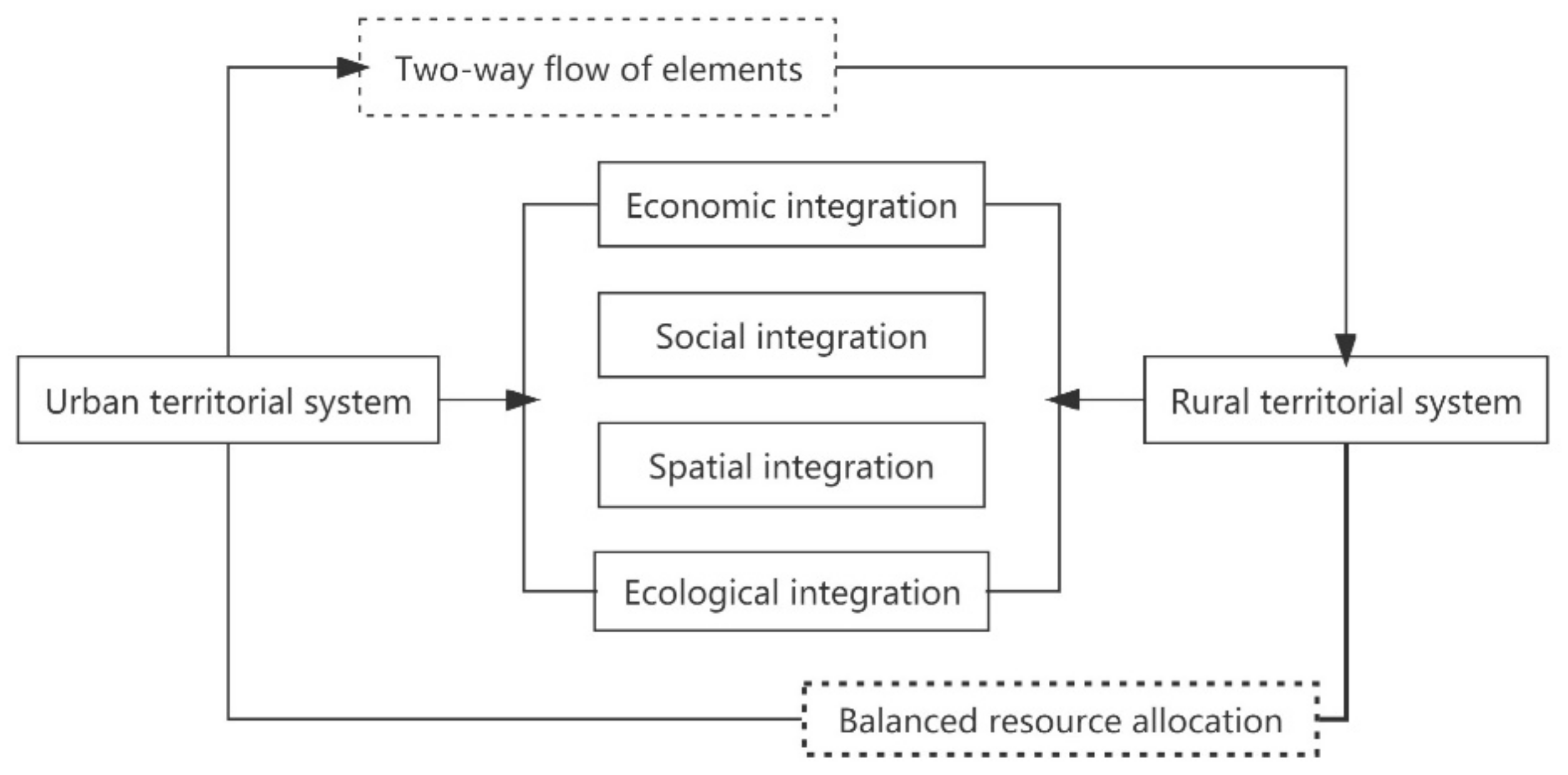
2.1. Definition of Connotation
2.2. Mechanistic Elaboration
3. Selection of Indicators and Research Methodology
3.1. Selection of Indicators
3.2. Research Methodology
- Measuring the level of the development of urban-rural integration
- Exploratory spatial analysis
- PVAR model construction
- Data sources
4. Analysis of Results
4.1. Chronological Evolutionary Characteristics of Integrated Urban-Rural Development
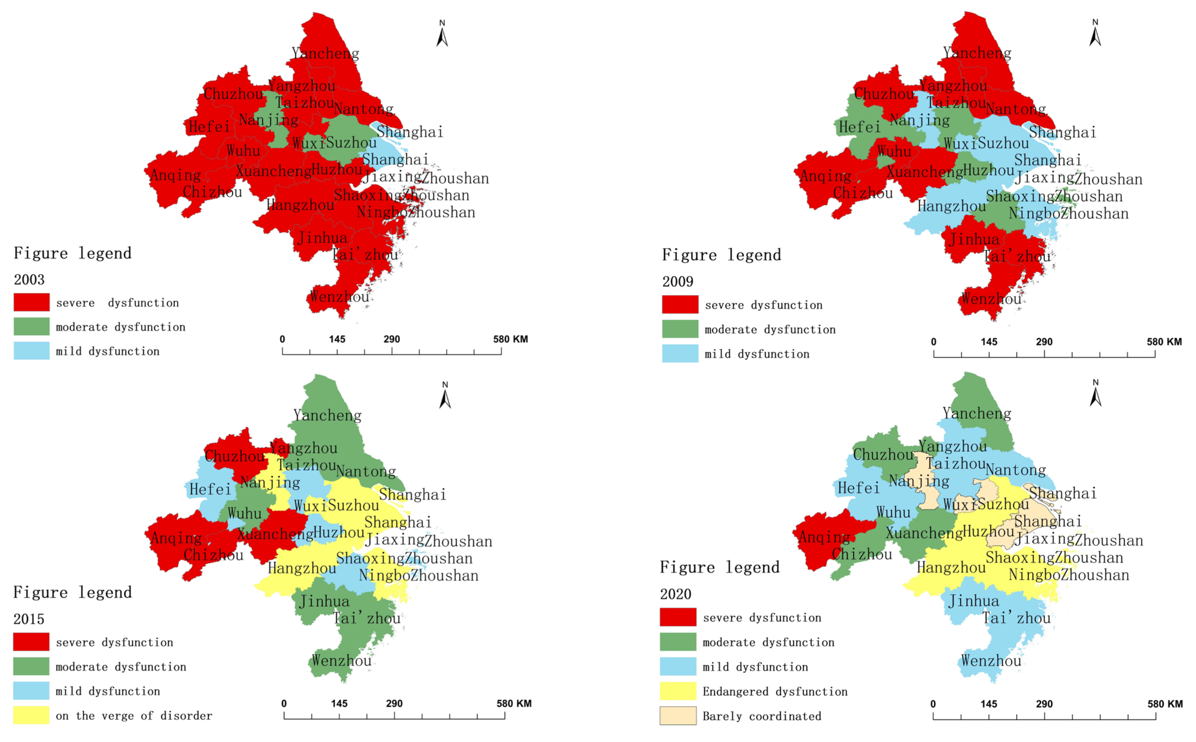
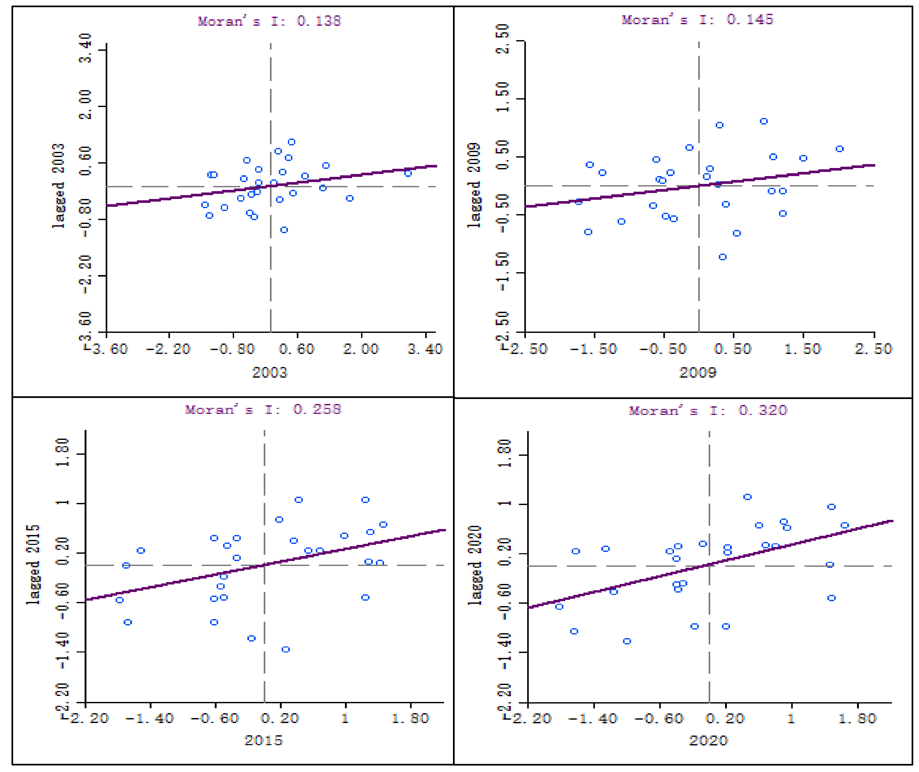
4.2. Analysis of the Spatial Characteristics of Integrated Urban-Rural Development
4.3. Analysis of the Dynamic Impact Effects of the Development of Urban-Rural Integration
4.3.1. Panel Data Testing
- Determination of the lag order
- Analysis of GMM estimation results
- Panel Granger causality test
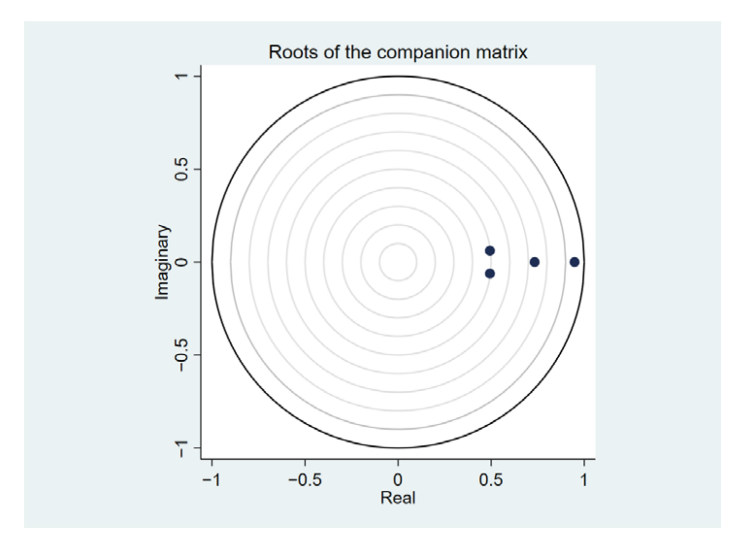
- Panel AR root test
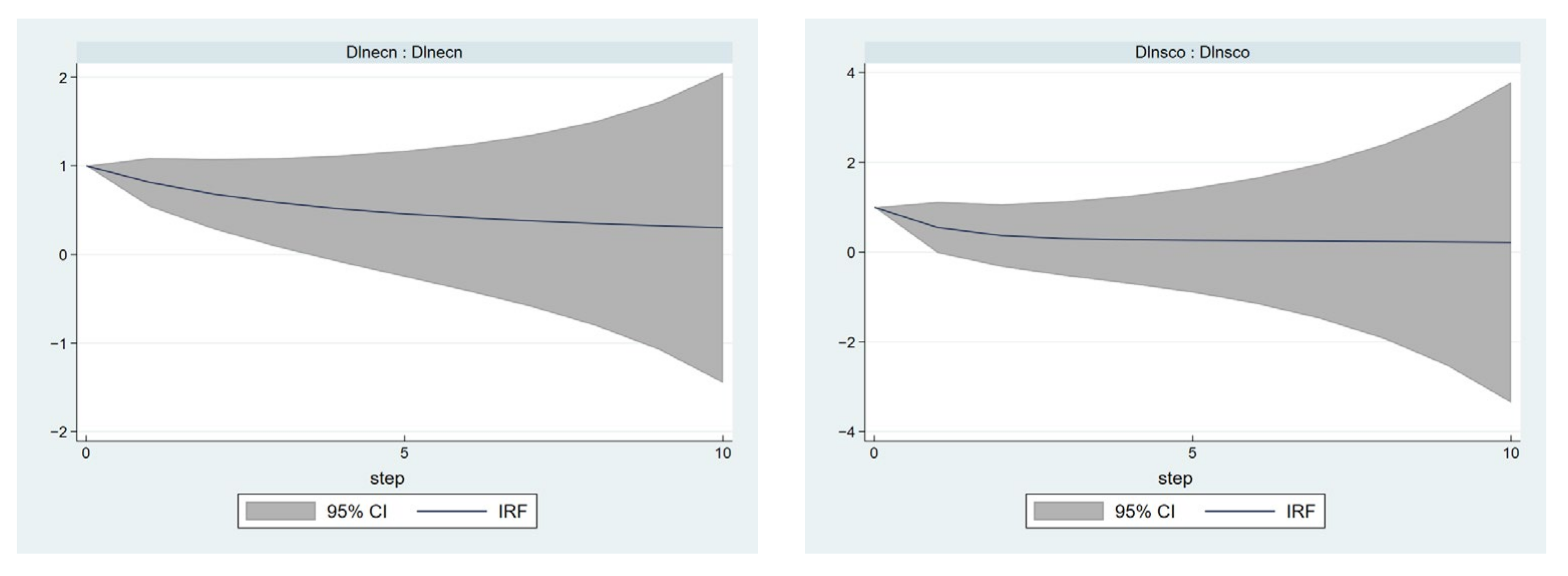
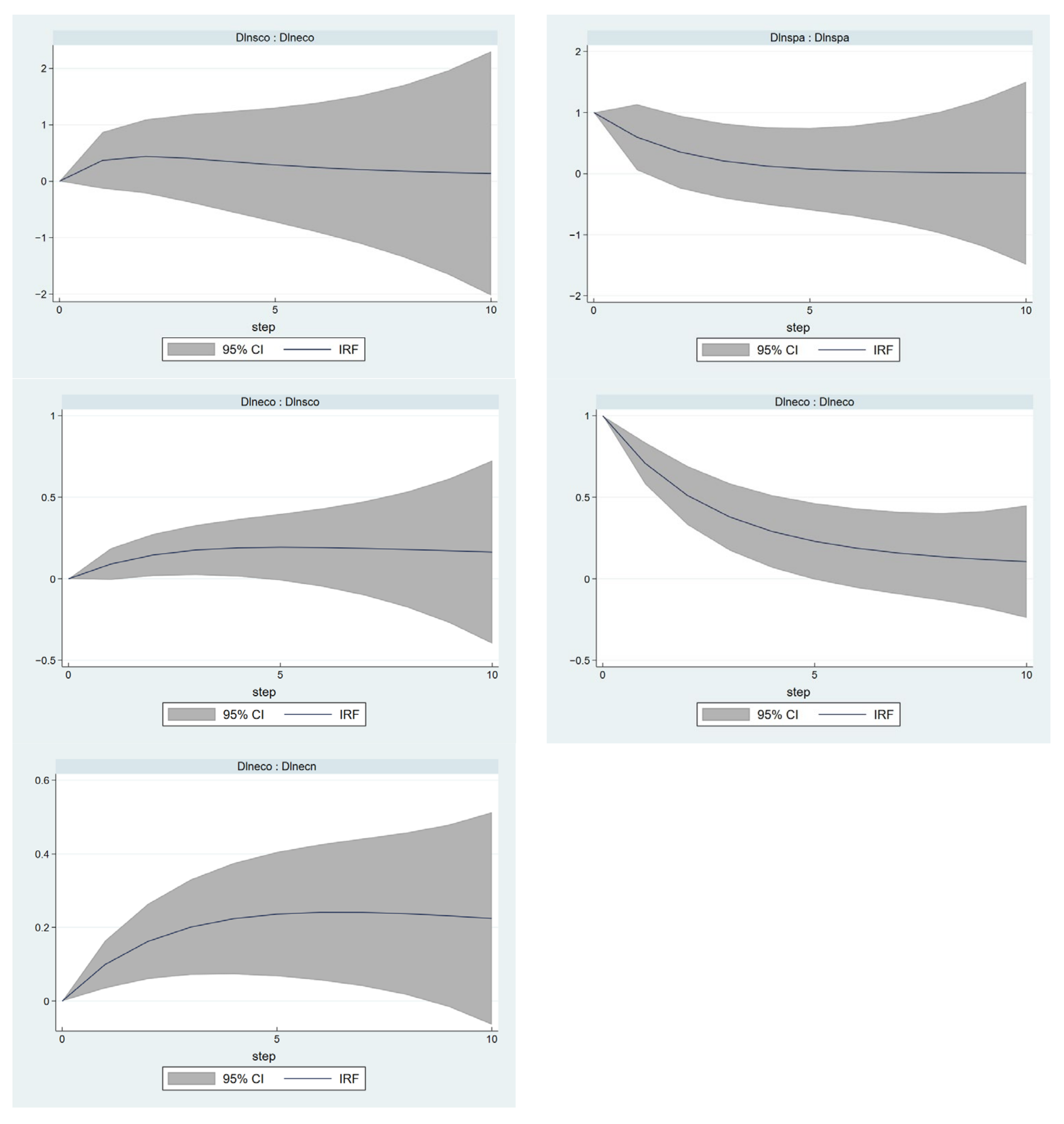
4.3.2. Analysis of Pulse Function Results
5. Discussion
5.1. Analysis of Spatial and Temporal Changes and Dynamic Effects of the Development of Urban-Rural Integration
5.2. Policy Recommendations to Improve the Integration of Regional Urban and Rural Development
6. Conclusions
- (1)
- In terms of time-series changes, the overall level of the development of urban-rural integration in the Yangtze River Delta region shows a fluctuating upward trend, undergoing an evolutionary process from severe disorder to moderate disorder to mild disorder; however, the overall development level is low and the regional disparities are more obvious, with the high value regions formed by the cities of Shanghai, Nanjing, Suzhou and Wuxi showing more significant differences from the low value regions formed by the cities of Anqing, Chizhou and Chuzhou.
- (2)
- For spatial distribution patterns, in the study period, a relatively significant agglomeration effect of the level of the development of urban-rural integration has been found in the Yangtze River Delta region, with Shanghai, Suzhou, Wuxi, and Jiaxing as the center. The high value areas of the development of urban-rural integration are largely concentrated in the central and eastern regions and coastal regions, whereas the low value areas are primarily distributed in the western and southwestern regions. The spatial distribution pattern shifts from “low level, low gap” to “high level, high gap”, and the spatial agglomeration effect tends to be strengthened from east to west. Shanghai and Anqing are the markers, showing the characteristics of decreasing class distribution, which leads to the spatial agglomeration distribution characteristics of “the weak are always weak, the strong are always strong”.
- (3)
- For the analysis of the dynamic shock effect of the development of urban-rural integration, all variables show a continuous positive response to shocks themselves, thus suggesting that the respective variable has a certain path dependence (inertia) on itself, whereas this path dependence varies between variables; urban-rural ecological integration change shocks can facilitate the improvement of the development level of urban-rural economic integration and urban-rural social integration, as well as urban-rural social integration change shocks. The shocks contribute to the improvement of the level of urban-rural ecological integration.
Author Contributions
Funding
Institutional Review Board Statement
Informed Consent Statement
Data Availability Statement
Conflicts of Interest
References
- Westlund, H. Urban futures in planning, policy and regional science: Are we entering a post-urban world? Built Environ. 2014, 40, 447–457. [Google Scholar] [CrossRef]
- Bennett, K.J.; Yuen, M.; Blanco-Silva, F. Geographic differences in recovery after the Great Recession. J. Rural. Stud. 2018, 59, 111–117. [Google Scholar] [CrossRef]
- McGee, T.G. The Emergence of Desakota Regions in Asia: Expanding a Hypothesis. In Implosions/Explosions; JOVIS Verlag GmbH: Berlin, Germany, 2015; pp. 121–137. [Google Scholar] [CrossRef]
- Liu, Y.; Hu, Z.; Li, Y. Process and cause of urban-rural development transformation in the Bohai Rim Region, China. J. Geogr. Sci. 2014, 24, 1147–1160. [Google Scholar] [CrossRef] [Green Version]
- Hualou, L.; Tingting, L.; Jian, Z. Analysis of dynamical mechanism of rural transformation development in typical regions of China. Econ. Geogr. 2011, 31, 2080–2085. [Google Scholar] [CrossRef]
- Yang, Y.; Bao, W.; Wang, Y.; Liu, Y. Measurement of urban-rural integration level and its spatial differentiation in China in the new century. Habitat Int. 2021, 117, 102420. [Google Scholar] [CrossRef]
- Long, H.; Liu, Y.; Li, X.; Chen, Y. Building new countryside in China: A geographical perspective. Land Use Policy 2010, 27, 457–470. [Google Scholar] [CrossRef]
- Liu, Y.; Zang, Y.; Yang, Y. China’s rural revitalization and development: Theory, technology and management. J. Geogr. Sci. 2020, 30, 1923–1942. [Google Scholar] [CrossRef]
- Liu, Y.; Schen, C.; Li, Y. Differentiation regularity of urban-rural equalized development at prefecture-level city in China. J. Geogr. Sci. 2015, 25, 1075–1088. [Google Scholar] [CrossRef]
- Wylie, J. Landscape and Phenomenology. In The Routledge Companion to Landscape Studies; Routledge: London, UK, 2013; pp. 72–83. [Google Scholar] [CrossRef]
- Meade, J.E. A Neo-Classical Theory of Economic Growth (Routledge Revivals); Routledge: London, UK, 2013; Volume 48. [Google Scholar] [CrossRef]
- Liu, Y.; Long, H.; Chen, Y.; Wang, J.; Li, Y.; Li, Y.; Yang, Y.; Zhou, Y. Progress of research on urban-rural transformation and rural development in China in the past decade and future prospects. J. Geogr. Sci. 2016, 26, 1117–1132. [Google Scholar] [CrossRef]
- Liu, Y.; Lu, S.; Chen, Y. Spatio-temporal change of urban–rural equalized development patterns in China and its driving factors. J. Rural. Stud. 2013, 32, 320–330. [Google Scholar] [CrossRef]
- Li, Y. Urban-rural interaction patterns and dynamic land use: Implications for urban-rural integration in China. Reg. Environ. Change 2012, 12, 803–812. [Google Scholar] [CrossRef]
- Liu, J.; Dou, Y.; Lu, Y.; Yang, L. Study on the spatial distribution characteristics of urban innovation power in Yangtze River Delta urban agglomeration. IOP Conf. Ser. Earth Environ. Sci. 2020, 474, 052070. [Google Scholar] [CrossRef]
- Fan, J.; Sun, W.; Yang, Z.; Fan, P.; Chen, D. Focusing on the major function-oriented zone: A new spatial planning approach and practice in China and its 12th Five-Year Planapv_1477 86. Asia Pac. Viewp. 2012, 53, 96. [Google Scholar] [CrossRef]
- Deng, S. Exploring the relationship between new-type urbanization and sustainable urban land use: Evidence from prefecture-level cities in China. Sustain. Comput.-Inform. Syst. 2021, 30, 100446. [Google Scholar] [CrossRef]
- Long, X.; Wu, S.; Wang, J.; Wu, P.; Wang, Z. Urban water environment carrying capacity based on VPOSR-coefficient of variation-grey correlation model: A case of Beijing, China. Ecol. Indic. 2022, 138, 108863. [Google Scholar] [CrossRef]
- Haken, H. An Introduction Nonequilibrium Phase Transitions and Self-Organization in Physics, Chemistry and Biology; Springer: Berlin/Heidelberg, Germany, 1978. [Google Scholar] [CrossRef]
- Renwei, H. Urban-rural integration and rural revitalization: Theory, mechanism and implementation. Geogr. Res. 2018, 37, 2127–2140. (In Chinese) [Google Scholar]
- Fan, J.; Li, P. The scientific foundation of Major Function Oriented Zoning in China. J. Geogr. Sci. 2009, 19, 515–531. [Google Scholar] [CrossRef]
- Fan, J.; Zhou, K.; Chen, D. Research innovation and application practice of economic geography in optimizing the development pattern of land and space in the construction of ecological civilization. Econ. Geogr. 2013, 33, 1–8. (In Chinese) [Google Scholar]
- Erlando, A.; Riyanto, F.D.; Masakazu, S. Financial inclusion, economic growth, and poverty alleviation: Evidence from eastern Indonesia. Heliyon 2020, 6, e05235. [Google Scholar] [CrossRef]
- Yu, J.; Zhou, K.; Yang, S. Land use efficiency and influencing factors of urban agglomerations in China. Land Use Policy 2019, 88, 104143. [Google Scholar] [CrossRef]
- San Chia, P.; Law, S.H.; Trinugroho, I.; Wiwoho, J.; Damayanti, S.M.; Sergi, B.S. Dynamic linkages among transparency, income inequality and economic growth in developing countries: Evidence from panel vector autoregressive (PVAR) model. Res. Int. Bus. Financ. 2022, 60, 101599. [Google Scholar] [CrossRef]
- Shao, Q.; Liu, X.; Zhao, W. An alternative method for analyzing dimensional interactions of urban carrying capacity: Case study of Guangdong-Hong Kong-Macao Greater Bay Area. J. Environ. Manag. 2020, 273, 111064. [Google Scholar] [CrossRef]
- Zhang, K.; Shao, S.; Fan, S. Market integration and environmental quality: Evidence from the Yangtze river delta region of China. J. Environ. Manag. 2020, 261, 110208. [Google Scholar] [CrossRef]
- Xiao, Y.; Wang, R.; Wang, F.; Huang, H.; Wang, J. Investigation on spatial and temporal variation of coupling coordination between socioeconomic and ecological environment: A case study of the Loess Plateau, China. Ecol. Indic. 2022, 136, 108667. [Google Scholar] [CrossRef]
- Andrews, D.W.; Lu, B. Consistent model and moment selection procedures for GMM estimation with application to dynamic panel data models. J. Econom. 2001, 101, 123–164. [Google Scholar] [CrossRef]
- Brana, S.; Djigbenou, M.-L.; Prat, S. Global excess liquidity and asset prices in emerging countries: A PVAR approach. Emerg. Mark. Rev. 2012, 13, 256–267. [Google Scholar] [CrossRef] [Green Version]
- Chen, M.; Zhou, Y.; Huang, X.; Ye, C. The Integration of New-Type Urbanization and Rural Revitalization Strategies in China: Origin, Reality and Future Trends. Land 2021, 10, 207. [Google Scholar] [CrossRef]
- Sheykhi, M.T. Rural—Urban Balance as a Measure of Socio-Economic Development with Special Reference to Iran. J. Soc. Econ. Res. 2016, 3, 1–12. [Google Scholar] [CrossRef]
- Rickardsson, J. The urban-rural divide in radical right populist support: The role of resident’s characteristics, urbanization trends and public service supply. Ann. Reg. Sci. 2021, 67, 211–242. [Google Scholar] [CrossRef]
- Liu, Y.S.; Li, Y.H. Revitalize the world’s countryside. Nature 2017, 548, 275–277. [Google Scholar] [CrossRef]
- Tacoli, C. Rural-Urban Interactions: A Guide to the Literature. Environ. Urban. 1998, 10, 147–166. [Google Scholar] [CrossRef]
- Ma, L.; Chen, M.; Fang, F.; Che, X. Research on the spatiotemporal variation of rural-urban transformation and its driving mechanisms in underdeveloped regions: Gansu Province in western China as an example. Sustain. Cities Soc. 2019, 50, 101675. [Google Scholar] [CrossRef]
- Tang, D.; Mao, M.; Shi, J.; Hua, W. The Spatio-Temporal Analysis of Urban-Rural Coordinated Development and Its Driving Forces in Yangtze River Delta. Land 2021, 10, 495. [Google Scholar] [CrossRef]
- Xu, H.; Jiao, M. City size, industrial structure and urbanization quality—A case study of the Yangtze River Delta urban agglomeration in China. Land Use Policy 2021, 111, 105735. [Google Scholar] [CrossRef]
- Zhao, J.; Zhu, D.; Cheng, J.; Jiang, X.; Lun, F.; Zhang, Q. Does regional economic integration promote urban land use efficiency? Evidence from the Yangtze River Delta, China. Habitat Int. 2021, 116, 102404. [Google Scholar] [CrossRef]
- Wu, Y.; Zhu, X.; Gao, W.; Qian, F. The spatial characteristics of coupling relationship between urbanization and eco-environment in the Pan Yangtze River Delta. Energy Procedia 2018, 152, 1121–1126. [Google Scholar] [CrossRef]
- Hou, Y.; Zhang, K.; Zhu, Y.; Liu, W. Spatial and temporal differentiation and influencing factors of environmental governance performance in the Yangtze River Delta, China. Sci. Total Environ. 2021, 801, 149699. [Google Scholar] [CrossRef]
- Jiang, C.; Li, J.; Liu, J. Does urbanization affect the gap between urban and rural areas? Evidence from China. Socio-Econ. Plan. Sci. 2022, 82, 101271. [Google Scholar] [CrossRef]
- Tan, S.; Hu, B.; Kuang, B.; Zhou, M. Regional differences and dynamic evolution of urban land green use efficiency within the Yangtze River Delta, China. Land Use Policy 2021, 106, 105449. [Google Scholar] [CrossRef]
- Wang, L.; Duan, X. High-speed rail network development and winner and loser cities in megaregions: The case study of Yangtze River Delta, China. Cities 2018, 83, 71–82. [Google Scholar] [CrossRef] [Green Version]
- Dong, L.; Longwu, L.; Zhenbo, W.; Liangkan, C.; Faming, Z. Exploration of coupling effects in the Economy–Society–Environment system in urban areas: Case study of the Yangtze River Delta Urban Agglomeration. Ecol. Indic. 2021, 128, 107858. [Google Scholar] [CrossRef]


| Objectives | Subsystems | Indicator Layer | Description or Calculation of the Indicator | Properties | Type of Indicator |
|---|---|---|---|---|---|
| Level of urban-rural integration | Economic integration | GDP per capita | Total regional GDP/total regional population/yuan | Positive | General |
| Non-farm industry ratio | Primary industry output/secondary and tertiary industry output/% | Negative | Contrast category | ||
| Ratio of urban to rural Engel’s coefficient | Urban Engel’s coefficient/rural Engel’s coefficient/% | Negative | Contrast category | ||
| Ratio of urban to rural household consumption per capita | Rural per capita consumption/urban per capita consumption/% | Negative | Contrast category | ||
| Ratio of urban to rural per capita income | Urban per capita income/rural per capita income/% | Negative | Contrast category | ||
| Fixed asset investment per capita in urban and rural areas | Urban and rural fixed asset expenditure/total population/yuan/person | Positive | Drivers | ||
| Social integration | Ratio of urban to rural expenditure on culture, education and recreation | Urban residents’ expenditure on culture, education and recreation/rural residents’ expenditure on culture, education and recreation/% | Negative | Contrast category | |
| Ratio of health care expenditure per capita in urban and rural areas | Urban per capita health expenditure/rural per capita health expenditure/% | Negative | Contrast category | ||
| Comparative coefficient of urban and rural transport communications | Urban per capita expenditure on transport and communication/rural per capita expenditure on transport and communication/% | Negative | Contrast category | ||
| Urban and rural pension insurance coverage | % | Positive | General | ||
| Urban and rural unemployment insurance coverage | % | Positive | General | ||
| Percentage of practicing physicians in urban and rural areas | Number of practicing doctors in urban and rural areas/total population/% | Positive | General | ||
| Ecological integration | Urban and rural domestic waste treatment | % | Positive | General | |
| Sewage treatment factor | Urban and rural sewage treatment rate/% | Positive | General | ||
| Industrial solid waste disposal | Urban and rural industrial solid waste disposal rate % | Positive | General | ||
| Spatial integration | Level of land urbanization | Area of built-up area/total land area/% | Positive | Drivers | |
| Level of population urbanization | Urban population/total population (%) | Positive | Drivers | ||
| Urban and rural mobility network | Road mileage in operation/total land area (km/km2) | Positive | Drivers | ||
| Urban spatial expansion factor | Area of built-up area/area under crop cultivation/% | Negative | General | ||
| Urban and rural employment headcount coefficient | Ratio of urban to rural population employed/% | Negative | General |
| Variables | LLC | IPS |
|---|---|---|
| Dlnecn | −4.2623 *** | −3.7429 *** |
| Dlnsoc | −1.38548 * | −6.0244 *** |
| Dlnxspa | −10.5302 *** | −7.6842 *** |
| Dlneco | −5.09022 *** | −7.5705 *** |
| Lag | CD | J | p-Value | MBIC | MAIC | MQIC |
|---|---|---|---|---|---|---|
| 1 | 0.999991 | 50.92931 | 0.359099 | −226.546 | −45.0707 | −117.506 |
| 2 | 0.999991 | 31.27899 | 0.502873 | −153.705 | −32.721 | −81.0111 |
| 3 | 0.999983 | 14.22208 | 0.582174 | −78.2698 | −17.7779 | −41.923 |
| Dlnecn Z-Value | Dlnsoc Z-Value | Dlnspa Z-Value | Dlneco Z-Value | ||||
|---|---|---|---|---|---|---|---|
| L. Dlnecn | 5.46 *** | L.dlnx1 | 1.17 | L.dlnx1 | 0.25 | L.dlnx1 | −0.88 |
| L. Dlnsoc | 0.73 | L.dlnx2 | 1.93 * | L.dlnx2 | 0.02 | L.dlnx2 | 1.38 |
| L. Dlnspa | 0.28 | L.dlnx3 | −0.86 | L.dlnx3 | 2.21 *** | L.dlnx3 | 0.72 |
| L.Dlneco | 2.9 *** | L.dlnx4 | 1.83 * | L.dlnx4 | −0.8 | L.dlnx4 | 10.23 *** |
| Original Assumptions | Chi2 Statistic | p-Value |
|---|---|---|
| Dlnsco cannot Granger cause Dlnecn | 0.54 | 0.463 |
| Dlnspa cannot Granger cause Dlnecn | 0.08 | 0.777 |
| Dlneco cannot Granger cause Dlnecn | 8.394 | 0.0004 |
| Dlnsco, Dlnspa and Dlneco cannot simultaneously Granger cause Dlnecn | 11.929 | 0.008 |
| Dlnecn cannot Granger cause Dlnsco | 1.38 | 0.24 |
| Dlnspa cannot Granger cause Dlnsco | 0.732 | 0.392 |
| Dlneco cannot Granger cause Dlnsco | 3.348 | 0.067 |
| Dlnecn, Dlnspa, Dlneco cannot Granger cause Dlnsco | 8.196 | 0.042 |
| Dlnecn cannot Granger cause Dlnspa | 0.062 | 0.803 |
| Dlnsco cannot Granger cause Dlnspa | 0 | 0.986 |
| Dlnsco cannot Granger cause Dlnspa | 0.643 | 0.423 |
| Dlnecn, Dlnsco and Dlnsco cannot Granger cause Dlnspa | 3.333 | 0.343 |
| Dlnecn cannot Granger cause Dlnsco | 0.767 | 0.381 |
| Dlneco cannot Granger cause Dlneco | 1.915 | 0.166 |
| Dlnspa cannot Granger cause Dlneco | 0.525 | 0.469 |
| Dlnecn, Dlnsco and Dlnspa cannot Granger cause Dlneco | 8.381 | 0.039 |
Publisher’s Note: MDPI stays neutral with regard to jurisdictional claims in published maps and institutional affiliations. |
© 2022 by the authors. Licensee MDPI, Basel, Switzerland. This article is an open access article distributed under the terms and conditions of the Creative Commons Attribution (CC BY) license (https://creativecommons.org/licenses/by/4.0/).
Share and Cite
Zhao, W.; Jiang, C. Analysis of the Spatial and Temporal Characteristics and Dynamic Effects of Urban-Rural Integration Development in the Yangtze River Delta Region. Land 2022, 11, 1054. https://doi.org/10.3390/land11071054
Zhao W, Jiang C. Analysis of the Spatial and Temporal Characteristics and Dynamic Effects of Urban-Rural Integration Development in the Yangtze River Delta Region. Land. 2022; 11(7):1054. https://doi.org/10.3390/land11071054
Chicago/Turabian StyleZhao, Wei, and Changjun Jiang. 2022. "Analysis of the Spatial and Temporal Characteristics and Dynamic Effects of Urban-Rural Integration Development in the Yangtze River Delta Region" Land 11, no. 7: 1054. https://doi.org/10.3390/land11071054
APA StyleZhao, W., & Jiang, C. (2022). Analysis of the Spatial and Temporal Characteristics and Dynamic Effects of Urban-Rural Integration Development in the Yangtze River Delta Region. Land, 11(7), 1054. https://doi.org/10.3390/land11071054