1. Introduction
Mining was part of the development of industrial society and a driving force behind the economic growth of the region. It provided employment, social security and livelihoods for families and, on the other hand, generated considerable revenue for regional and state budgets. It has been an accelerator of technological development, knowledge of the natural laws and of education. After mining ceased for various reasons (political, economic, environmental, legislative and changes in the social composition of the population), many mining sites and their surrounding areas found themselves in a state of insecurity compared with the heyday of mining. Mining activity (the extraction of raw materials) in Slovakia was mainly carried out underground, and the basic processing of the raw materials was carried out in facilities and structures on the ground, usually in the vicinity of the extraction or adjacent to the mining site. Following the cessation of mining activities, the transformation and protection of mining heritage values became an acceptable way for many towns to preserve a direct industrial legacy for the general public. The level of attractiveness of mining-related activities is one of the determinants of tourism development success.
The revitalization of sites is logical, as many regions of Slovakia originally focused on mining activities became devastated social hotspots after the end of mining and often found themselves on the periphery of economic interest and social development. The idea of the Slovak Mining Road was established in 1991, following the decline of ore mining [
1].
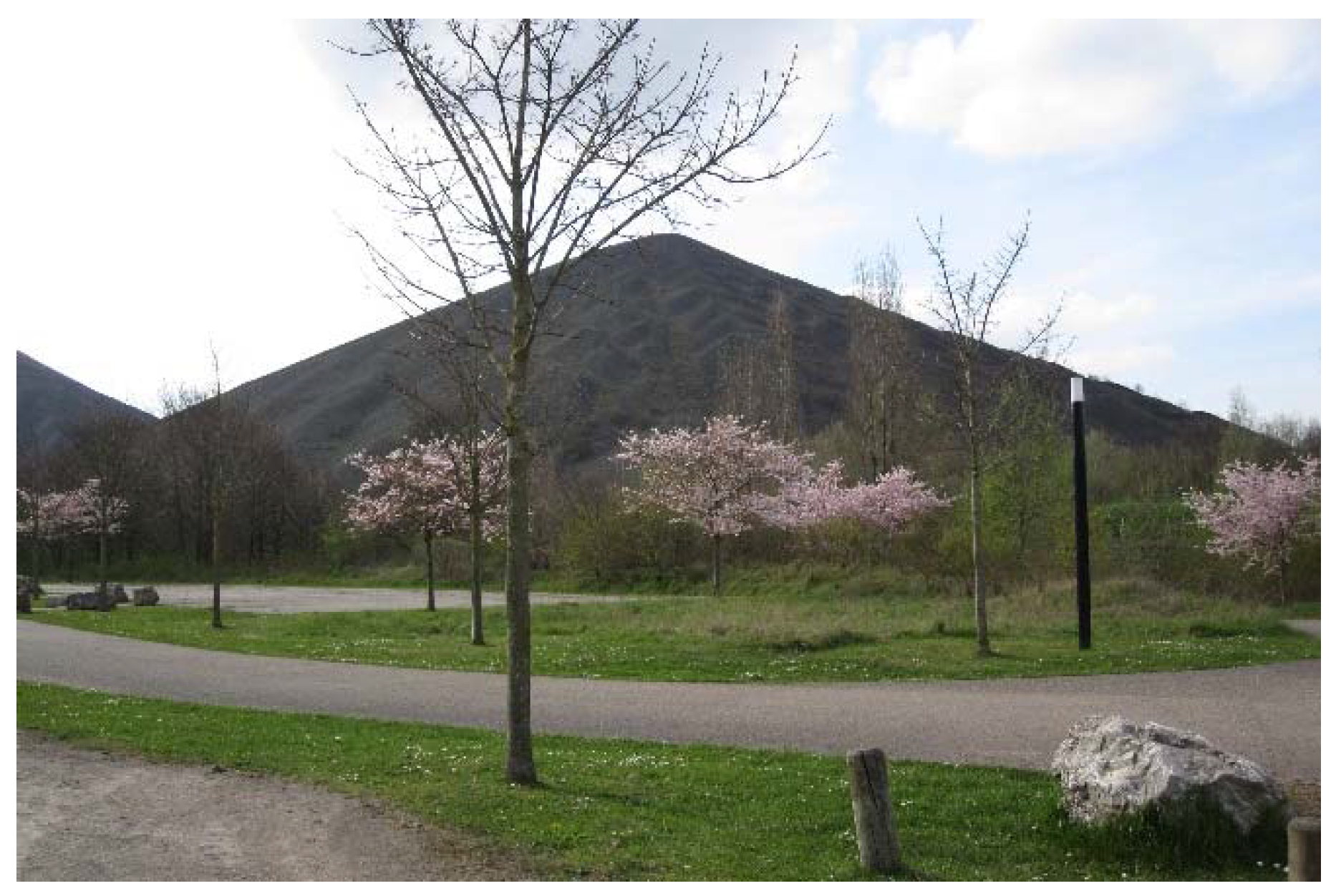
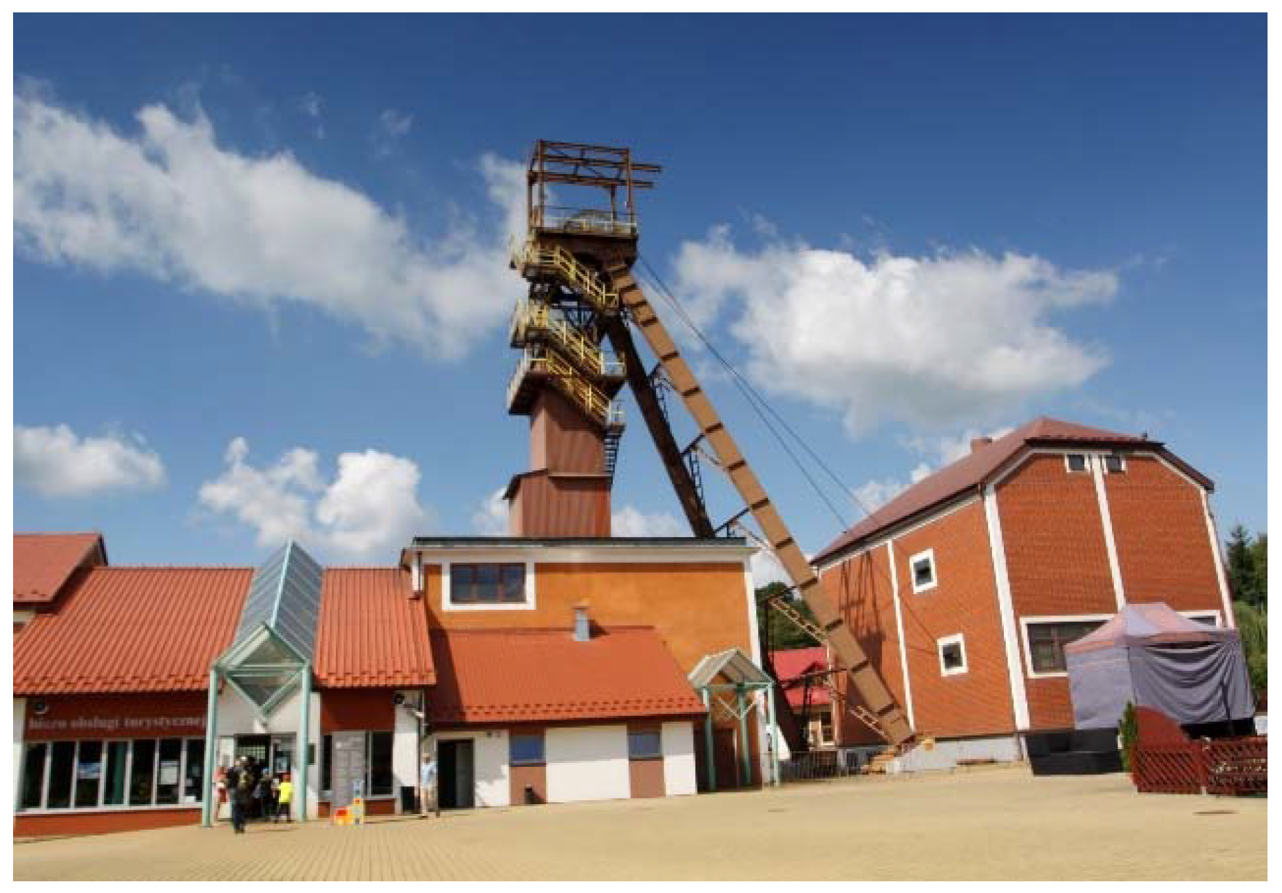
Foreign examples document possible approaches for the conversion of such sites. Two preconditions are required—the first is societal interest in preserving the values and historical traces of mining activity, and the second is sufficient economic opportunities. There are many good international examples of the reanimation of mine workings and the processing of mined minerals, ores and mining landscape revitalization,
Figure 1 and
Figure 2. To give an idea of the atmosphere, a few sites can be mentioned: in the German Ruhr area (Zollverein), in the north of France (Nord-Pas de Calais Mining Basin, Lens), in Belgium (Mine Cultural Centre, Genk), in England (Threlkeld), in Hungary (The Matra Power Plant) in Poland (“Former Mine” Science and Art Centre, Wałbrzych; Bochnia Salt Mine), in Czechia (Vítkovice) [
2,
3,
4,
5]. These are examples of mining and quarrying activities and the operation of the unique techniques and technologies on which the concept of their conversion is based [
6,
7].
Slovakia also has suitable examples of its own. The rich history of mining is represented mainly by mining sites and mining colonies in central, eastern and northern Slovakia [
8,
9]. These sites represent the potential for the development of tourism following the example of metallurgy and mining trails. The research focuses on the areas of northern Slovakia, the Spiš region and the Markušovce site. The subject of the research is to present mining as a part of specific forms of ecotourism (mining trail, eco-park, geopark, eco-geopark) [
6,
10,
11,
12]. The aim of the research is to contribute to the formation of sustainable tourism and to the creation of a diverse environment and landscape through imaginative and gentle revitalization. An important characteristic is the educational dimension of tourism [
13,
14].
The first hypothesis of the research is that just as mining in the past was a guarantee for the comprehensive development of the region, similarly, nowadays, mining trails will contribute to revitalization, presenting problematic and marginal areas with opportunities for development. The second hypothesis is that the activities related to mining trails are necessary for the sustainability of the subject areas, tourism, employment and cultural landscapes. The main output of the research is the evaluation of case studies of eco-parks as part of mining and geo-tourism trails and as an integral part of the landscape, based on the identified areas of value and potential. The research includes the presentation of participatory design tools and results and their transformation and application in the case studies.
The importance of the presented research results lies mainly in the level of presentation and searching for ways of revitalizing the mining areas along with trends in the sustainability of the social, economic, urban and landscape environment in the background of the history of mining activities. The results of the case studies can serve as topics for the functional and territorial space organization of mining areas; they can also be applied to various regions outside Slovakia.
The study on the issue has confirmed that original mining localities are subject to transformation and accompanying meaningful development today. In modern society, it is natural for cities to try to document the intertwining of their history with industrial and mining activities and to constantly reassert it from one generation to the next. In this way, the continuity of development, the wider context and the culture of a society are preserved. Mining trails and parks contribute to this continuity by creating a modern educational platform for the general public.
The concept of mining nowadays, in addition to the original traditional mineral mining, also includes the extraction of building materials, aggregates and gravel and the extraction of raw materials in other ways, by means of drilling (oil, gas), which is outside the subject of our research.
The subject of the research does not include an evaluation of mine workings with respect to the safety and rehabilitation of the mine workings, nor a determination of the conditions suitable for conversion and further use [
15]. These issues constitute a separate research issue.
2. Overview of the History of Mining Activity in Slovakia
The research relies on historical materials that underline the importance of addressing the issue. Only the basic development facts are presented in the paper.
Mining in Slovakia has had a long and rich history, both in terms of the historical origins of mining activity and also in terms of the diversity of raw materials, number of sites and methods of extraction [
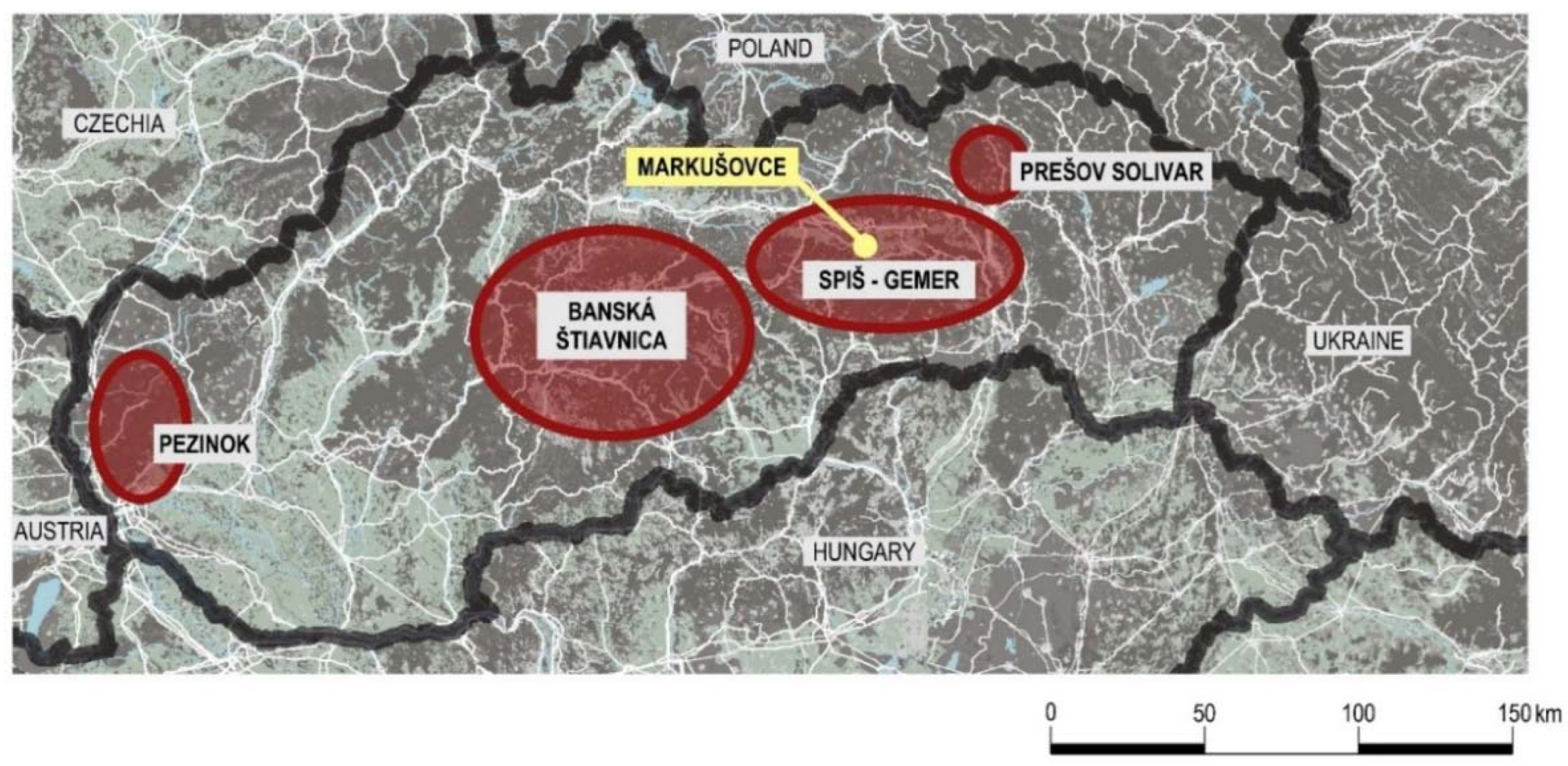
16]. As in other European countries, mining began with the extraction of precious metals, stone, salt, coal and oil. The tradition of mineral extraction was also reflected in the names of nearby towns. In many cases, we can find the adjective mining or the noun mine in town names or see some other connection with ore mining (for example, mining: Banská Bystrica, Banská Štiavnica, Banská Bela; mine: Nová Baňa; ore: Nitrianske Rudno, Rudňany, and others). The locations of mining activity can be found almost all over Slovakia and are a natural consequence of the geological and geographic development of the territory, especially under the influence of volcanic activities. The best-known sites are in the mountainous regions of Slovakia (Spiš, upper and lower Gemer, with their link to the Košice basin, the area around Banská Štiavnica, Prievidza, Handlová and partly near the western Carpathian massif around Bratislava) [
9,
17]. In this way, mining areas were established in which the various mining companies operated. As regards the broader significance and scale of mining, three major mining regions were created in Slovakia: Spiš, Gemer and Banská Štiavnica, which also enjoyed the longest period of mining, especially of ore minerals. As regards the intensity of mining, the history of architecture and town formation, Banská Štiavnica and its surroundings are considered to be the jewel of mining in Slovakia. The area has a long and interesting history connected to mining. Already in the times of the Celts, gold and silver were being mined here. The Celts also knew the technology for processing the surface ore, silver and gold they obtained from mining [
8].
In the 10th century, the mining of silver and gold was already important in the area of Banská Štiavnica, which was considered very attractive due to the high content of metals in the surface parts of the deposits. Underground mining began after the arrival of German miners in the thirteenth century. The technical breakthroughs made by the Hell brothers through their ingenious system of pumping underground mine water date from this period [
8].
Banská Štiavnica gradually became one of the most important mining centers in Hungary. It was here that in 1735 the royal surveyor Samuel Mikovíni founded the first mining school, while in 1762, Maria Theresa established the Mining Academy, the world’s oldest technical school. Technical education in Slovakia was carried out on its principles. The entire historical center of Banská Štiavnica is connected with the history of mining, with the establishment of mining museums and an open-air museum. Educational and experiential tours of mining tunnels and water reservoirs have been organized in the area. In terms of the sustainability of mining tourism, Banská Štiavnica has an advantage since the town, together with the technical monuments in the vicinity, is a UNESCO World Heritage Site. There are some 360 objects of artistic and historical merit within the town’s conservation area.
Another example of equipment renovation is on the brine (salty water) extraction territory in Solivar, near Prešov. Small positive changes and mining trails are now found in a number of localities in Slovakia. On the map of Slovakia, the main mining regions are presented,
Figure 3.
The second most important mining region of Slovakia is Spiš, which, in a figurative line, includes mainly the sites of Spišská Nová Ves, Markušovce, Rudňany, Poráč and Slovinky. There is also a continuation of the mining line towards the south to the southeast to the Gemer region and the Košice basin. These regions represent the highest density of mining activity sites in Slovakia historically and so represent the potential for the creation of educational trails. The history of mining in Spiš and other Slovak regions is discussed in detail by the authors Jesenák, Lacko and Jančura, in their publications [
8,
9,
18].
The research is primarily focused on the Markušovce-Rudňany-Poráč valley. It is a typical example of forgotten mining sites in the Spiš region. The most important milestones in its development can be found in the history of the region. The village Markušovce has developed since the beginning of the 12th century as a small center of the lower Spiš with varying degrees of commercial, agricultural and mining focus. It was part of a large trade route leading from Spiš to the Lower Land. One of the main sources of income was the mining business in Spiš and Markušovce. The right to operate a mine for gold and silver on one’s own property was granted in 1344. In Markušovce, ore processing from neighboring Rudňany and Poráč also dominated. The mining activity in the village was focused on tunnels for the supply of water for mining activities. At present, the village Markušovce belongs to the Spiš region, the center of which is the town Spišská Nová Ves. The oldest data date back to 1255. Historical documents describe the area, later a mining settlement called Kuffurbach-Medený Potok (Copper stream), and the present name of the village of Rudňany was recorded in 1947. The village was a ruler’s toll station on the trade route to the center of Spiš. The development of mining in the 14th and 15th centuries was particularly influenced by the village of Poráč (then called Červený Vrch) from as early as 1277.
Towns that were granted mining rights were considered to be important centers of industry, culture and education. The dangerous mining profession, on the other hand, carried economic and social advantages. Rural towns grew up around the mines—mining dwellings were built, the necessary road infrastructures were created, and commercial and cultural amenities developed. Miners were generally held in high social esteem, and their great status was emphasized by their traditional dress. The mining slogans, “I’m a miner—who’s more?” and “everything for the miners”, were maintained for a long time. Given the difficult, dangerous and unattractive nature of the work, this was considered their due.
By the end of the 20th century, there was a worldwide decline in the mining and coal industries. This brought social and economic problems (unemployment, weak purchasing power, emigration) to mining areas. The mining sites in Slovakia were not exempt from this trend. Disused mining facilities and buildings began to deteriorate rapidly. The mining life and the mining spirit disappeared from these sites. Within a few decades, a turnaround was taking place, especially in Western Europe. Today there is demonstrable interest in the history and heritage of mining in situ [
7,
19]. The case studies presented here were established on the basis of this fact.
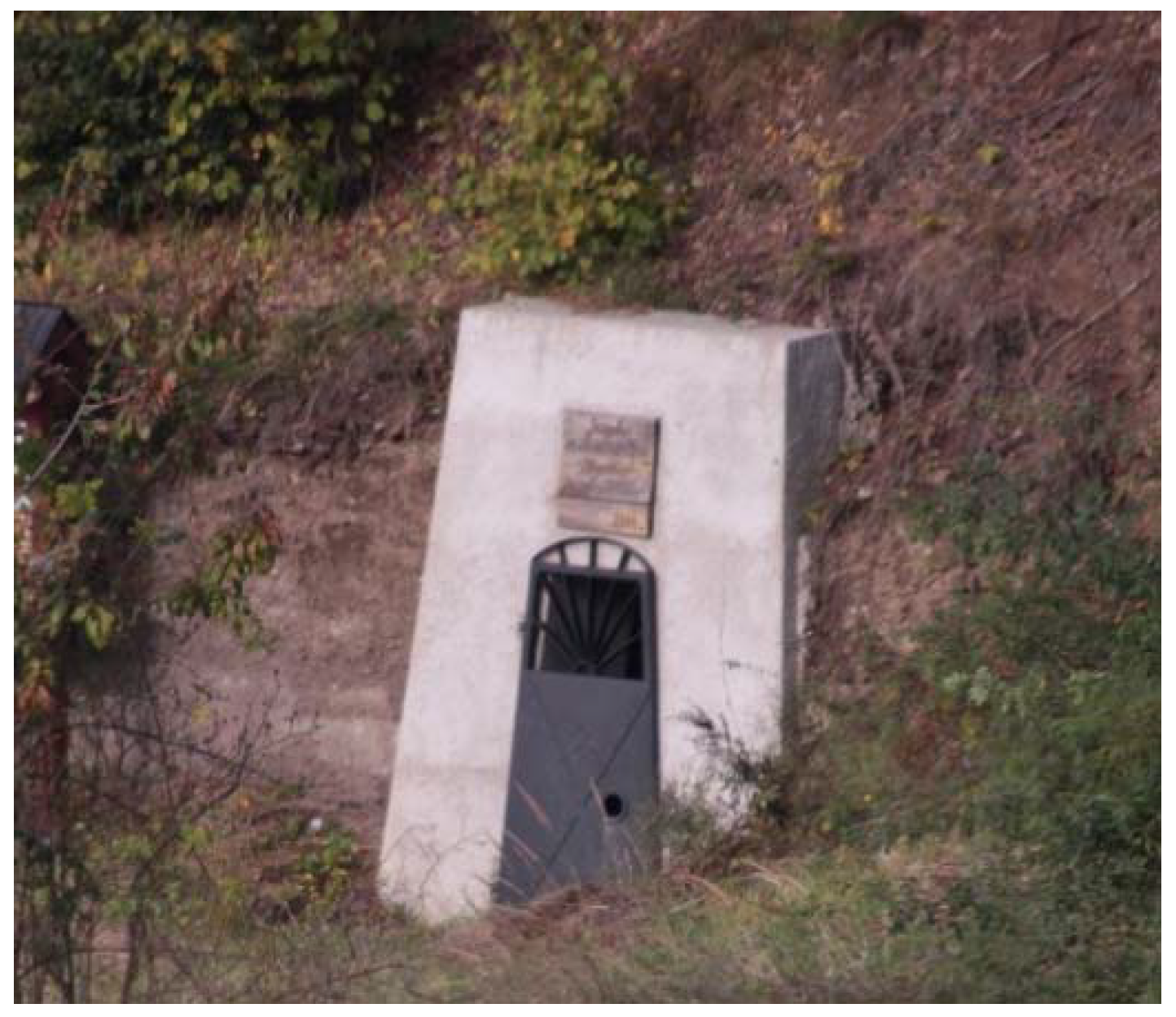
In the sites of Markušovce, Rudňany and Poráč, there remain fragments of a technical mining open-air museum (e.g., the tower of the shaft and the engine room in Poráč, entrance portals to the tunnels). It should be stressed that due to undermining and flooding of parts of the Rudňany site territory, there are fewer possibilities of access to the mine workings. However, there is a great potential for a link to the circular Spiš-Gemer mining trail, which is parallel to the existing historic Spiš Gothic Route. This was the main reason for linking the research content of historical traces together with the search for a solution for the specified mining area in the form of alternative case studies. The negative starting point is that the site has gradually become a “socially deprived island” without significant development, which, in turn, is a challenge for research.
The authors Armis and Kanegae [
20] state on this issue: Additionally, post-mining cities are burdened by defunct mining facilities and over-sized and derelict infrastructure. Overall, these unfavorable scenarios lead to the perception of post-mining centers as unlivable places of decay and disinvestment, saddled with bleak environmental images, all of which impede new investments or industry.
3. Materials and Methods
3.1. Determination of Research Questions
The research questions are directed toward former mining areas as part of the educational trails. Based on the facts of mining history and an evaluation of selected historical contexts, as well as current status and field research, three basic research questions were identified as emerging from the overall context of the topic:
What is the development potential of the original mining sites?
What are the possibilities of tourism development in the background of mining in the site of Markušovce-Rudňany-Poráč?
What can be the role of landscape design in the revitalization of mining sites?
3.2. Research Methods
In order to achieve relevant answers to the research questions, several research methods, basically divided into analytical and synthetic methods, were used. In the first part of the research, analytical and participatory methods were applied to work with the opinions of the respondents of the local community. The authors emphasized the need for public participation in the design process, as it is important to reconcile subjective feelings, the individual’s perception of the problem and community-wide interest. This method has been applied to define the goals and procedures for the revitalization of the area [
21]. The research method is presented in the diagram, see
Figure 4. The research methods in the first and second research questions focus on analysis, comparison and evaluation, as the questions relate to facts and given values concerning the site. The result is models for educational trails. The third question is related to the creative solution, with the case studies as the dominant method. The comparison of the case studies resulted in the creation of basic concepts for the landscape role of eco-parks in the revitalization of localities.
As part of the research, it was necessary to establish a methodology for gathering information and knowledge in order to identify a site and establish a site program for the case studies. Part of the research was focused on the site selection criteria, the identification of values and the development potential of the “mining valley” in the following areas:
Physical values:
urbanistic-architectural monumental values
technical equipment and artifacts values
other historical and documentary values
Environmental values:
Territory potentials
territorial development potential—amenities, infrastructure
recreational–tourist potential
mining infrastructure use potential
Other intangible potentials
educational
cultural
social
After evaluating the areas (values and potentials) in
Table 1 and
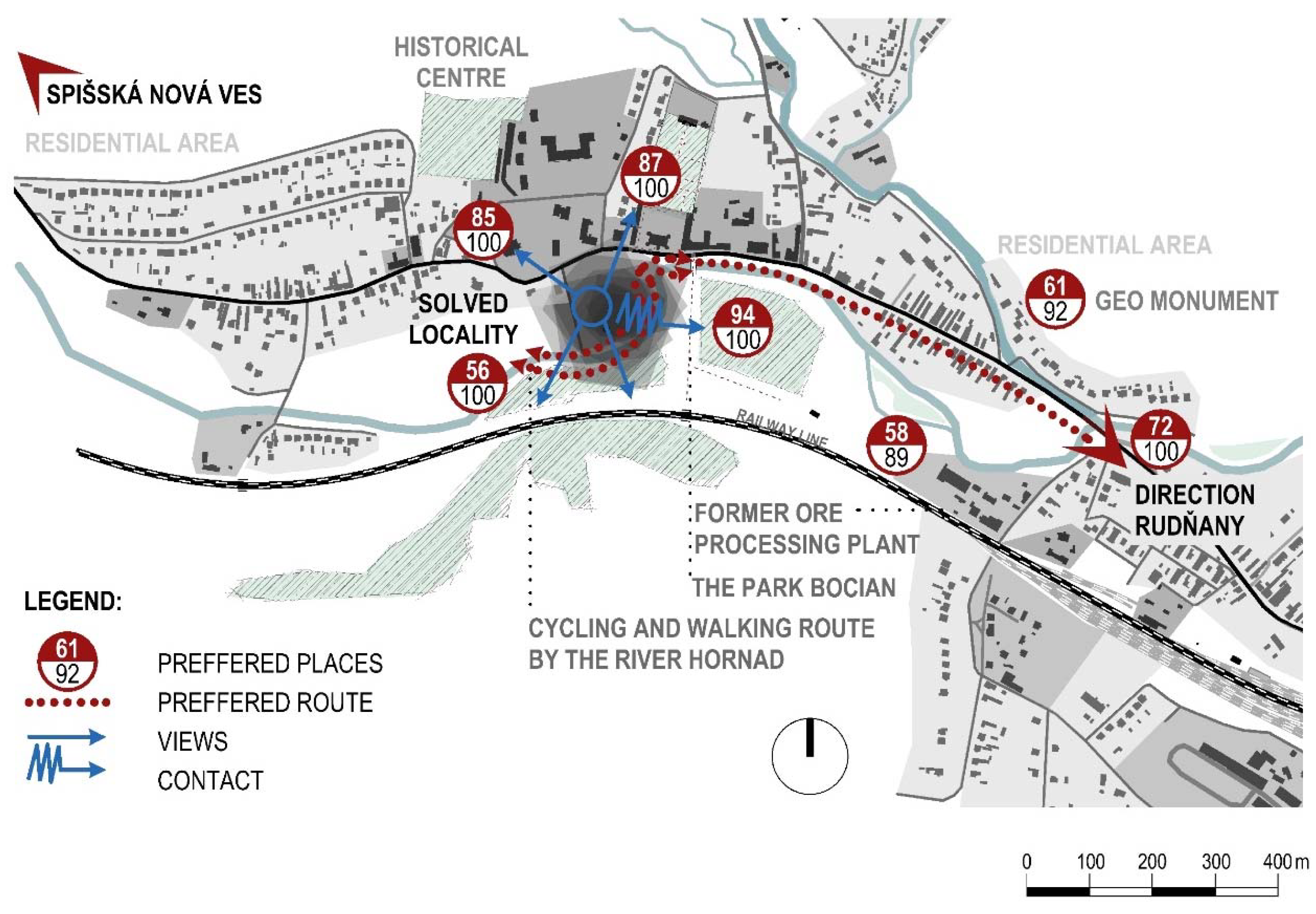
Table 2, the selection of a site for locating the educational park as part of the trail followed. It turned out that the village of Markušovce met the established criteria with high creditworthiness of values and potential. In the village is the highest creditworthiness of the set values in four of the six categories and has potential in up to five of the six categories. The next step was the specification of the case study site, which was based on the results obtained from the field and participatory research,
Figure 5,
Figure 6 and
Figure 7.
At this stage of the research, a combination of several participatory method tools was used to measure respondents’ attitudes. A questionnaire that was understandable to the public was designed to facilitate clear responses with the prerequisite of being transformed into a case study. Today, citizens often want to apply their ideas to the environment, with the public proving to be the most influential factor in creating the environment [
22].
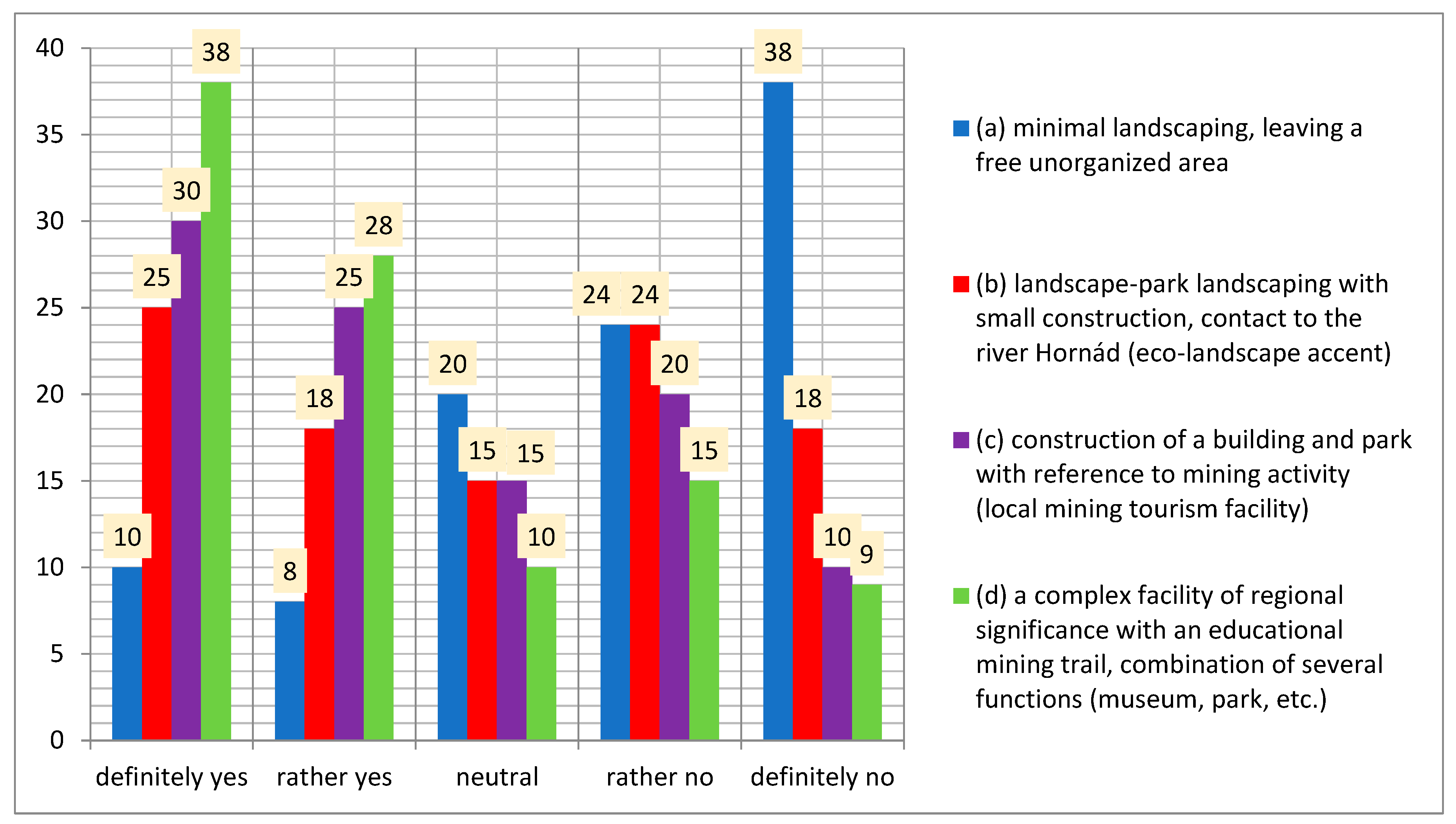
The most commonly used methods of measuring attitudes include the Likert scale, which helps respondents to express an opinion measurable on a scale. To select the respondents—the research sample, a so-called available sample was used. The questionnaires were conducted during several days of field research with 100 respondents from Markušovce and Rudňany.
For the relevance of the results, the questions were formulated in a clear, unambiguous way, and the most widely used and validated model with 5 levels of response evaluation was adopted: definitely yes/rather yes/neutral/rather no/definitely no [
23,
24].
In this phase, two participatory research objectives were worked with in order to obtain relevant views on the planned revitalization of the area. The objectives were as follows:
objective—obtaining opinions on the functional revitalization and transformation of the area in the form of a questionnaire (measured according to the Likert scale). The questions were formulated as follows:
Would you like the following to be implemented in the area:
- (a)
minimal landscaping, leaving a free unorganized area
- (b)
landscape-park landscaping with small construction with contact to the river Hornád (eco-landscape accent)
- (c)
construction of a building and park with reference to mining activity (local mining tourism facility)
- (d)
a complex facility of regional significance with an educational mining trail with a combination of several functions (museum, park, etc.)
objective—obtaining opinions for the creation of an emotional map.
In conversion and revitalization, emotional maps are used as a supporting tool of the participatory method in the development of an urban-architectural concept [
25]. What are the reasons? The original function leaves strong emotional traces on the inhabitants. So-called generational memories (memories passed on to the next generation) often persist in the form of a direct or indirect bond. The reason for the strong emotions is the perception of the genius loci of a place. Emotional maps give the inhabitants the space to express their feelings. Each inhabitant may have a different opinion on a “territorial“ problem, a different idea, which results from the depth of his/her knowledge of what is happening in the settlement, his/her cultural outlook, his/her own convictions, personal and mediated memories and mental equipment. For the authors of the studies, the emotional maps are both inspiring and provocative and to some extent, binding. On the basis of the emotional map, the research looked for operational routes and locations that residents would like to highlight and possibly add to the focus territory. In creating the map, respondents were asked to do the following:
- (a)
mark the route and the places where you most like to go:
- -
walking, cycling, relaxing…
- (b)
mark the place that is for you:
- -
the most beautiful (with which you associate a favorable emotion, a memory of an event or other aesthetically or historically valuable place…)
The results of the participatory research, see
Figure 8 and
Figure 9, revealed that natural beauty, traces of the mining heritage, the history of the settlement, architectural monuments from Gothic to Rococo (castle, manor house, summer palace), the French park and technical monuments are the most attractive elements for the respondents. These results became the main impetus for the development of mining tourism and became a springboard for the development of alternatives in the case studies.
The input information for the case studies (second part of the research–synthesis) included the identification of the location and objects that would determine the revitalization of the site and enrich the design of the mining tourism trail as part of geo-tourism. The primary group consists of existing objects with a clear value (historical, architectural). The second group includes geo-places and technological traces strategic for the illustration of the genius loci of mining. The third group consists of new objects needed in the context of the educational trail and the geo-park.
The evaluation of case studies is a part of the research results and discussion. The research also made use of knowledge and methodological experience from the field of the author’s research on the conversion of industrial buildings and the revitalization of complexes [
26,
27].
4. Research
4.1. Tourism and Mining Trails
The research is oriented towards linking the issues of mining educational parks and trails with tourism. To understand the problem, it is important to correctly grasp the concept of tourism. The term tourism and its meaning in terms of development and in relation to mining tourism have been described by Różycki and Dryglas [
28]. They characterize the various types of tourism and focus attention on the sociological aspect of the phenomenon of mining tourism. The reasons for visiting the sites are presented as an aid to the design of a successful mining tourism route (escape from everyday problems, relaxation and regeneration, parallels with places of pilgrimage, experiential knowledge of the difficult conditions of mining, exploration of the site).
Ecotourism is based on exploring the values of nature, which is a major attraction. The combination of forms of tourism (e.g., with historical and industrial trails, exploring ethnographic heritage) leads to the more significant promotion and development of tourism—in line with the principles of respect for and protection of the natural and cultural heritage, of course [
9].
According to Dowling (2001), there are five key principles that define ecotourism as follows: it is nature-based, ecologically sustainable, environmentally educative, locally beneficial and generates tourist satisfaction [
29].
Exploring a tourist site can be part of geotourism, which is becoming a trend as opposed to the usual type of consumer tourism. “Geotourism” is concerned with preserving a destination’s geographic character—the entire combination of natural and human attributes that make one place distinct from another. Geotourism encompasses both cultural and environmental concerns regarding travel, as well as the local impact tourism has upon communities and their individual economies and lifestyles [
30,
31]. Geotourism is one of the core activities of geoparks, which are under the umbrella of geographic tourism.
Geoparks, as a logical part of modern geotourism, are based on the local geo-heritage and on the preservation of specimen sections of nature. Their basic mission is not only to preserve and present this heritage but also to develop the region. This is achieved through independent visits to geological features, the use of geo-trails and viewpoints, guided tours, geo-activities and patronage of geosite visitor centers [
7,
32]
Geoparks promote the “twin aims of [protecting] geological heritage and enhancing the public understanding of earth science, and with a third aim of using these to promote sustainable economic development on a regional level” (European Geoparks Network, 2010) [
33]. The local inspiration is the Novohrad-Nógrád geopark. It is the first international (cross-border Slovakia-Hungarian) geopark in the UNESCO European Geoparks Network and Global Geoparks Network.
The landscape forms a backdrop around the former mines that is just as dramatic as the economic void left by their closure [
34]. Options were researched in the area of potential replacing the lost extensive industrial activity. The only logical way is the systemic linking of mining sites to tourist routes. A good example comes from England, where the British Geological Survey, along with the Coal Authority, has released an interactive mapping tool showing where mines are located and specifying potential problems, so planners can identify new sustainable project opportunities [
35].
For the Markušovce area, an outline of sustainability and ensuring stability was specified to eliminate haphazard practices and facilitate the creation of an educational trail. The principles of sustainability, according to Huba [
36], include, among others, the fulfillment of ecological principles, the principles of cultural and social integrity and the principle of acceptable mistakes with the necessary minimization of irreversible changes [
37]. The outline mentioned above applies these principles and is used in case studies to maintain the sustainability of a site and promote its potential:
the need to develop the image of the settlement and the mine site (the necessity for good tourism management)
the implementation of thematic sightseeing tours focused on the history of the site, with an emphasis on mining and geo-location
the exploitation of the natural and cultural potential of the mining heritage for ecotourism and geotourism (specially adapted non-invasive educational trails for viewing natural phenomena caused by mining activities)
design of non-invasive experiential attractions related to the site and mining activities (presentation of mining, the life of miners, with links to sport and recreation)
accessibility of the sites (transport infrastructure)
opportunities for the development of tourism-related services for all categories of the population (also in terms of universal design) [
38]
In an effort to comprehensively address the research problem in the area, it was necessary to determine alternatives for linking eco- and geo-tourism with the mining heritage. Is there such a connection? The following points justify the connection and, at the same time, exploit the potential of the site for tourism development:
- (a)
former mining sites provide access to special geological and aesthetic landscape rarities revealed by mining
- (b)
features of opencast mines (natural or built) can be unique formations
- (c)
the negative impacts of the activity on the landscape gradually disappear with the closing of the mines; this change has a positive impact on the environment
- (d)
they present a form of in situ education (in the field of environmental science, geology, biology, culture and history)
- (e)
provide a therapeutic dimension (beneficial effects on people during their stay, e.g., in salt mines)
4.2. Case Studies
In the development of the case and model studies, procedures that consider stakeholder requirements at the outset of concept development were chosen. Many experts confirm the irreplaceable cooperation of the local people and stakeholders in the design of eco- and geo-parks and their sustainability. International cooperation, where different communities exchange expertise, knowledge and methods based on multi-scenarios of landscape use and conversion, is also of high importance [
39].
One of the objectives of the research was to verify in an applied way how to meaningfully use and transform the “black holes” left from mining activities into environmentally acceptable areas on the selected site. The research focused on “white patches”—benefits from the former mining sites of Markušovce-Rudňany-Poráč. The aforementioned factors regarding the connection between geotourism and the mining heritage, along with the components of tourism sustainability within the site were applied. The participation of the local population in activities and workshops is expected, which is part of the attempt to improve the local economy of rural areas located near the subject eco-park. Similar findings are in the research of the authors Farsani et al. [
40].
The first plan was a reflection on the physically visible historical traces of mining activities and the value of the mining heritage, with links to mining technology and the field of geology. On this basis, a combined educational trail form for the study site was identified.
The second plan involved the transposition of mining symbols and the revitalization of the selected site connected with mining activities in the form of an eco-park plus a mining park.
Each project was based on its own analyses, which evaluated a wider territory and were not limited to Markušovce, thus providing inspiring input data. An emotional map was compiled to look for the ideal educational trail and the points that residents would like to accentuate or add to the area.
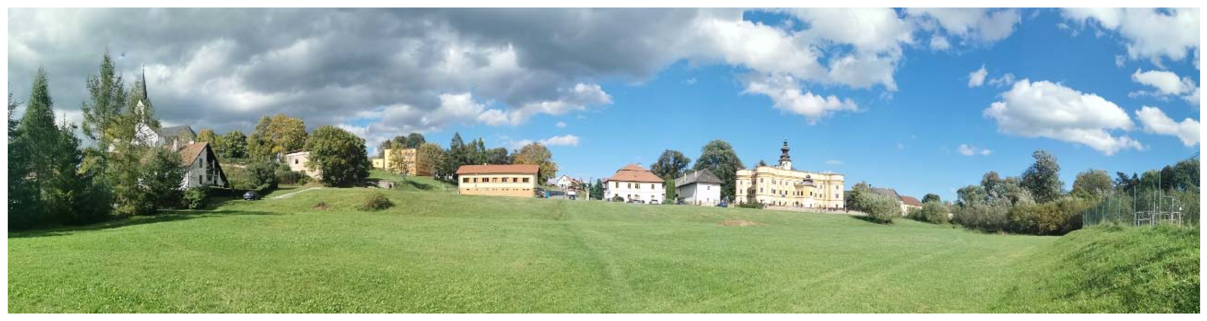
The strengths of the Markušovce site include good accessibility from district towns (Spišská Nová Ves—6 km and Levoča—17 km). The cultural, social and cognitive center of the regional history is the Spiš-Gemer Gothic Route, which includes Markušovce and its several monuments (a summer palace, a manor house, a castle and a historical park). The area in question has an exceptional location. It is in contact with the historical zone, a park with valuable trees, and the exceptional meander of the Hornád river. The area has a slight slope to the south, towards the Hornád river. Although minerals were not mined here, the village was inhabited by miners and ore was locally processed. The mining activity in Markušovce has left an extensive historical, social and ecological footprint. A major challenge in the presented studies was how to deal with these facts in the territory of Markušovce, a town with a rural expression.
4.2.1. Case Study 1a
The concept heightened the landscape impact through the design of the buildings taking advantage of the slope of the terrain. The objects emerge from the underground and are modeled on the basis of the nature of the mining activity. The setting transmits the anxious feelings of the miners and the impact of their activities on their psyche. Hard and dangerous work, cramped conditions, gloomy spaces, claustrophobia are keywords for the creation of this study. The transformation of physical and psychological demands is presented in the operational concept, in the routing of visitors’ movement and in the identification they pick up as the tour progresses. Three-dimensional exhibitions, written documents and digital presentations are displayed, but above all, the form and shaping of the space are intended to evoke the feeling of confinement experienced by the miners. Facilities for workshops and refreshments are added, as these are lacking in the village. These activities are in a contact position with the landscape. It is possible to take advantage of the local mining heritage to develop new products related to the ore processing (such as workshops that demonstrate traditional activities and the community’s way of life) [
41].
The resolution highlights and enhances views and vistas, accentuating the context of the surroundings,
Figure 10.
4.2.2. Case Study 1b
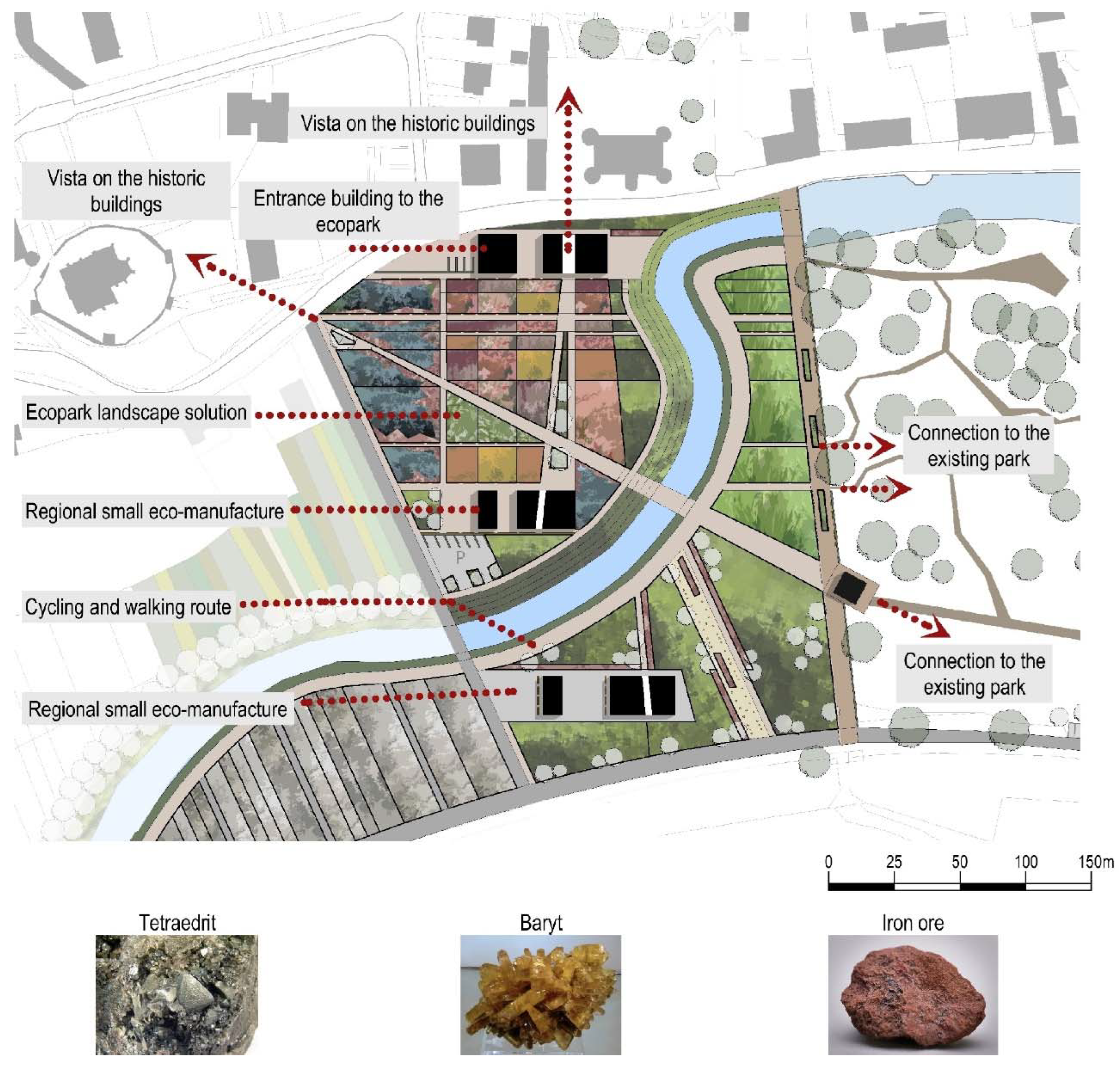
The main compositional axes of the eco-park are based on the original historical landmarks of Markušovce and literally create the division of the proposed park. In the concept, an abstraction of the surrounding agricultural landscape and the architecture of the buildings in Markušovce and its surroundings was applied. The eco-park “works” with the phenomenon of flora and rocks that are typical for the area. The setting is dominated by the aesthetics of the landscape in the articulation of the proposed park, using the colors of plants, which are the dominant compositional element. The objects literally grow out of the beds and implant functions in the territory that complement the character of the eco-park (they present the following: the history of flora and geology in the territory, the cultivation and drying of medicinal plants, workshops related to phytopharmacy),
Figure 11.
Well-functioning ecotourism (as well as other types of tourism) deeply influences consumer satisfaction and, therefore, the return of tourists. As a result, the destination and its community will benefit through higher incomes and increased employment [
42].
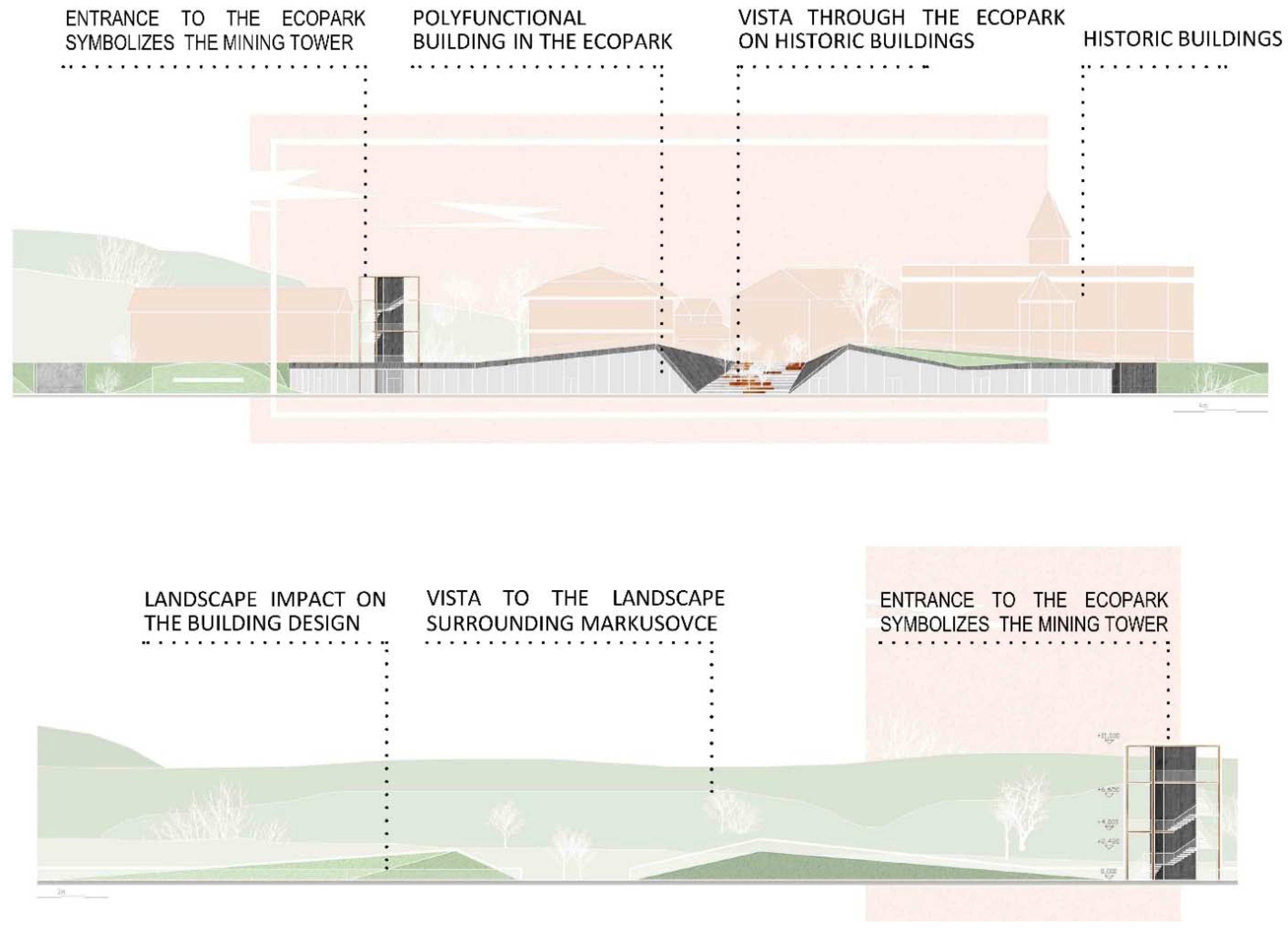
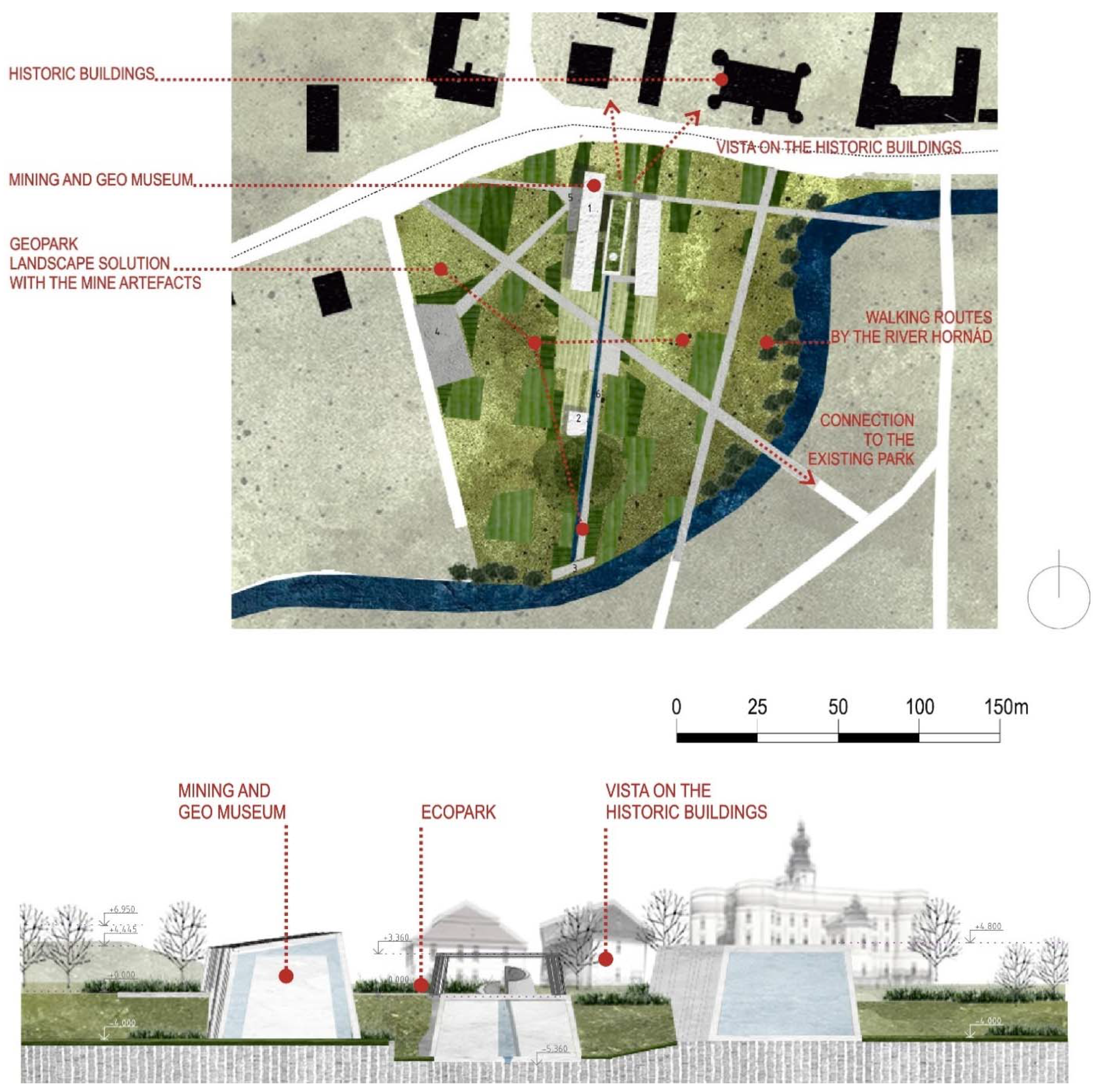
4.2.3. Case Study 2a
The concept of the building presents three locations (Markušovce, Rudňany, Poráč) and three activities:
which it places in three units. There are museum and exhibition spaces with the character of stylized tunnels and with a construction that evokes sinkholes—the architecture of mining tunnels transforming a number of symbols of mining activity into interior elements and exterior sets, with interactive presentations pushing the design toward the unconventional. The design is dominated by the building but still interacts strongly with the landscape. The concept of the building complements the context: an imaginative landscaping addition to the site, making the complex a gateway to a nature trail,
Figure 12.
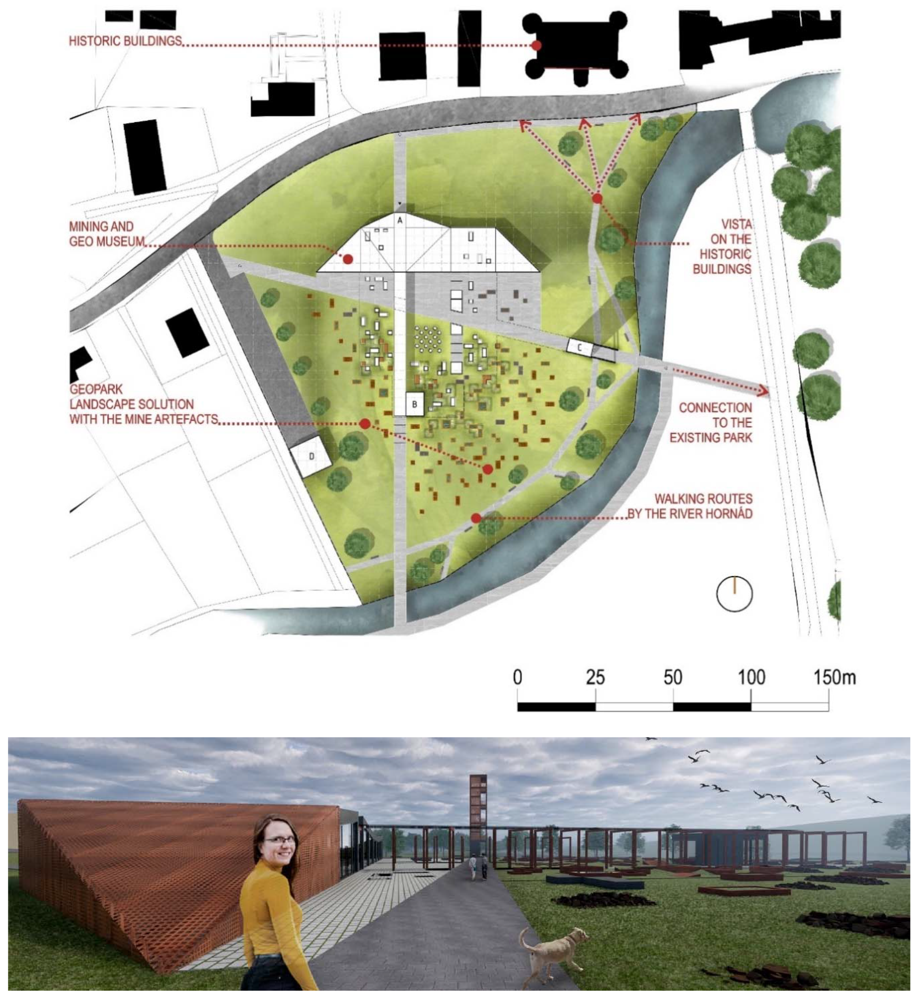
4.2.4. Case Study 2b
The concept of the building presents the philosophy of the mine and transforms it into a museum operation. It transitions seamlessly from the surface to the underground, and, at the same time, there is contact with the exterior from the underground. All the elements of the mining identity are transformed—the mine entrance, the mine cross-section, the cross-views, the connecting tunnel. The material resolution of the objects and the landscape design present in the concept and in detail not only the mining activity (the heirloom tunnel, the mine’s towing tower, the small strip mining) but also the geology of the site. A positive aspect of the resolution is the eco-friendly concept of the new building—modern vegetated roofs and rainwater catchment.
The design is subtly dominated by the museum building, which completes the landscape design through the insertion of a number of symbols of mining activity and elements of geology,
Figure 13.
5. Research Results
The results and contribution of the research effects several areas: mining, ecotourism, geotourism and sustainability. Relevant input data and facts were a prerequisite for the success of the case studies of the Markušovce Ecopark, which subsequently generated the attitudes of the research team. It was a summarization of possible opinions and expert inputs, which were based on theoretical knowledge of the history of the site, its architecture, production activities, landscape features and socio-demographic knowledge, along with the potential for economic and cultural development and tourism. This is a specific area, historically experiencing relatively intensive mining activity in the Spiš region. The mining character of Markušovce gives the site new hope for the cultural revitalization of the area and of the wider landscape. The typical mining elements in the architecture complete the character of the landscape as modified by mining and point to the harmony of the historical industrial architecture with the other elements of the natural and cultural heritage of the territory [
1].
A good local eco-park and the educational trail program guarantee that visitors will revisit the sites. The attraction that a geographic location provides causes motivations for tourists to feel attracted to visit [
12]. The case studies present the attractiveness of the Spiš mining region against the historical background of the settlement of Markušovce and the distinctive mining history of the nearby settlements of Rudňany and Poráč. The strengths of the site are combined with the potential that the case studies have successfully uncovered,
Table 3.
Research has shown the dimensions of the economic and social importance of area revitalization, which, in turn, determine a link with the tourism industry while promoting regional and social development. The revitalization and conversion of territory brings a multiplier effect, as the value of the site grows in direct proportion to the extent of environmental and aesthetic-landscape interventions, with increasing educational-cognitive, presentational and cultural dimensions.
The attractiveness of the designed sites is further enhanced by the offer of follow-up activities and the exploitation of other values of the landscape that motivate visitors to come repeatedly and to get to know the mining region. From the point of view of mining industry preservation, there are great opportunities for the development of mining tourism. Elements of mining appear on the foundation of the original mining activity and complete the character of the geotourism trails.
Geoconservation and ecotourism are key concepts that can be conducive to spatial development in former mining regions [
38]. Geotourism has a great educational dimension, using its tools to show the wider public the importance of geological science. We have to re-build the bridge between our knowledge of the Earth, its history and landscape and the modern society’s total dependence upon Earth’s natural resources, a link that was apparent to generations past [
43]. Geotourism may thus be considered a part of natural area tourism and ecotourism [
44].
At this level, it was important to reflect on and respond to the views of residents, which expressed satisfaction with the site in relation to tourism (eco and geotourism). According to the authors [
42], there exist factors of satisfaction. These act positively on the transfer of information about destinations and present a willingness to return to a place. Satisfaction factors can include the values of the site, e.g., natural beauty, cultural level, infrastructure quality and services.
The case studies highlight the values of the historic buildings that come in contact with the study area and are part of the Gothic Route. The studies, on the other hand, shape the new mining trail as a parallel to the existing historic route. Markušovce can then be seen in a broader context, not only as part of the mining trail, but also as a gateway to the proposed eco-park. In the education of architects, the need to think on two basic levels, the conceptual and the contextual, is underlined: If a student attempted thinking at only one level, the case study/project would not result in socially acceptable architecture [
45]. This applies to architectural design generally.
The research confirmed the two landscape conceptual approaches applied in the studies of the building design in the eco-park:
1. The impact of the landscape on the building—the dominance of the landscape in the design and shaping of the mass that merges with the landscape (case studies 1a–b).
2. Interaction with the landscape—the design of the object interacts with the landscape (case studies 2a–b).
Both concepts highlight the phenomenon of the landscape, which is not just an accessory but a strategic compositional element in the solutions. A diagram of the concepts has been created that explains the philosophy behind the two guiding principles, see
Figure 14.
Similarly, Refaat understands the eco-park concept with a simple, sustainable site design that takes advantage of natural site features and minimizes negative impacts on the natural environment. This should create an environment reintroducing appropriate vegetation and ecological diversity throughout the designed site [
46].
The proposed eco-park is part of the mining educational trail. The research then responds to the possibilities of presenting mining activities (in general):
- (a)
in the form of a historical technical museum with a mining theme
- (b)
in the form of an open-air mining museum (exterior exhibition of shaft and engine house objects)
- (c)
in the form of “in situ” mining archaeology (underground mining tunnels and shafts of a vertical or cave type, technical recharge systems—drilling rigs, lift cages, virtual visual and audio demonstrations of mining)
- (d)
presentation of period buildings, parts of buildings and their equipment, which characterizes mining, artifacts of mining (mining towers, engine rooms, technological and constructional components of the mine, equipment of dressing rooms…)
All of the mining presentations defined in (a)—(d) were determined as appropriate for the study site and mining trail.
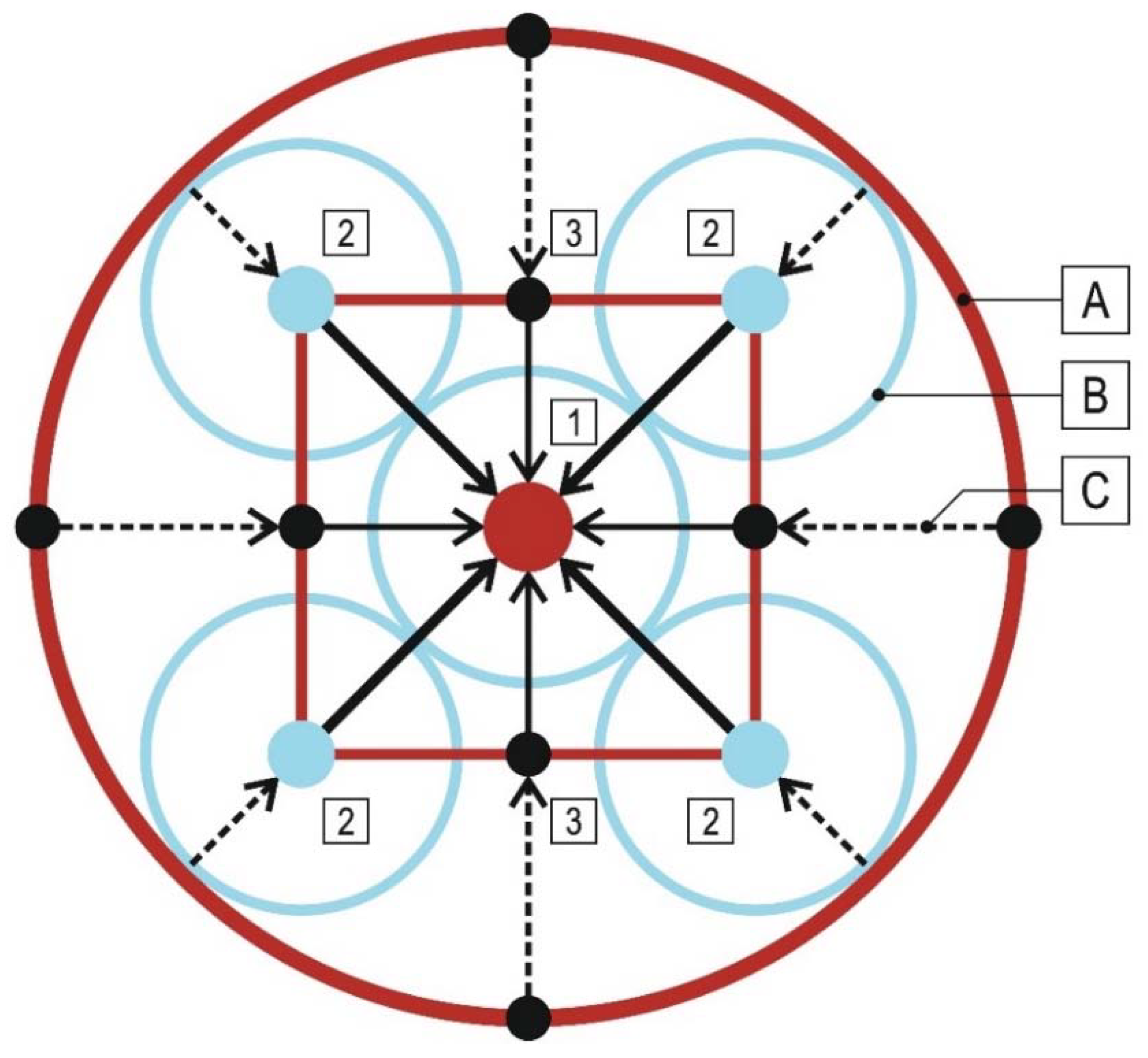
By the linking of exceptional and strategic points for trails, there emerge three general operational trail models based on the logic of movement and the possibility of routing:
The definition of models is important for the logical deployment of related services and activities linked to tourist routes,
Figure 15 and
Figure 16. Moreover, and from the visitor’s point of view, it is important to have the opportunity to choose from different, although complementary, types of tourism routes, each offering a significant variety of tourism activities capable of interesting the tourist [
6].
6. Discussion
The results can be discussed in light of scientific studies and can be compared with implemented educational trails. The salt mines in Poland (Wieliczka-Bochnia) are especially inspiring in their presentation of adventure mining tourism underground. The revitalization of the area and the possibilities of ecotourism in Lens, France, have also made a significant contribution. The priorities of the stated implementations form a part of the addressed studies.
Inspiring research was conducted by the authors Edwards and Llurdés i Coit [
47]. They distinguish four groups of assets frequently made accessible in converted mines and quarries: productive attractions, regarding the landscape, marks left on the surface or underground from previous mining activity; processing activities, such as workshops or demonstrations of traditional activities; transport attractions, related with the rail, water or road transports that served the working mine; socio-cultural attractions, such as “artifacts”, “sociofacts” (about social organization practices) or “mentifacts”. These activities and attractions accordingly found a relevant place in the case studies.
As noted by Armis and Kanegae [
20], the original activities can be switched to a different mode using the new potential of the territory to provide further economic benefits. Given its wide-ranging impact, once the mining activity is over, it is necessary to switch to other activities to kick-start the affected regions towards economically efficient activities in order to maintain the stability of the region [
48].
The mining education routes (tourism) provide numerous short-, medium- and long-term advantages for the local society, the environment and for the regional economy (e.g., mitigation of visual impacts and residues left by mining, geodiversity, population environmental awareness and biodiversity) [
12,
19]. Authors Briševac et al., in the case studies, apply these contemporary trends and promote a new form of tourism that is mostly oriented to the 3 × E rule with and strong educational component (education, entertainment and excitement) instead of the usual model referred to as 3 × S (sun, sea and sand) [
49].
The current trend is for mining-related works to become cultural or technical monuments and for their history to be passed on to future generations. Nevertheless, it is unrealistic and unsustainable for all structures and fragments to be made usable as museums or exhibits. Ultimately, although the owner of the mining property will have the decisive influence, there needs to be community-wide interest in preserving the genius loci and the historical values of mining activity at the site. Within the concept of a regional solution (educational route), it is necessary to create a value map to determine the sequence of the revitalization of sites and objects. This process should be formally institutionalized and involve cooperation with researchers, municipalities and cultural institutions in the region. If culture does play a role in urban conflict, then we are required to explain how people perceive and evaluate the urban landscape and why different groups may develop competing understandings of the same space [
50]. Therefore, if the mining culture is to play a significant role in mining localities, it is important to create the possibilities for the development of the relationship between tourism, ecology and geology, all related to the original mining.
Different ways of revitalizing regions are highlighted by the authors of the publication [
41]. The hopes are that this will allow the strengthening of heritage mining tourism as a valued element of diversified tourism, placed together with other typologies as part of a regional development strategy that relies on tourism as a relevant sector for rural development. The presented models of mining educational trails outline new territorial potentials and point out valuable elements to strengthen ecotourism and geotourism. In the case study, the authors Mandal et al. [
51] similarly create the possibility for visitors to also take advantage of the opportunities to visit abandoned mines and surrounding popular tourist sites during one trip.
For the conversion to work, it is important to see the issues and apply multi-stakeholder and expert collaboration. Additionally, post-mining towns are burdened by defunct mining facilities and over-sized and derelict infrastructure. Overall, these unfavorable scenarios lead to the perception of post-mining places as unlivable places of decay and disinvestment saddled with bleak environmental images, thus impeding new investment or new industry. The collaboration between players with practical knowledge and mining practitioners can provide new, creative and innovative projects drawing on empirical knowledge from different theoretical perspectives [
20].
Responsible tourism planning has been applied in the design process of the educational trails. The aim of responsible planning and management is to rely on validated information from the areas concerned (landscape, territory, architecture, history…) to ensure that design decisions are correct and that solutions are of high quality [
52]. Planning for responsible tourism, ecotourism and geotourism must respect the interests of all stakeholders and so requires systemic solutions and, consequently, responsible tourist behavior [
53].
Geotourism management should first and foremost focus on the quality of the visitor’s experience since the success of geotourism in delivering its goals of geoheritage education, sustainable development and geoconservation are ultimately dependent on this experience [
54]. The case studies were created in harmony with it.
Educational trails create a system of services and activities. A large number of the activities generate a multitude of relationships between supply and demand [
55]. Ideally, there is a balance of supply and willingness on the part of recreationists to accept the activities. Otherwise, the activities disappear or the reputation of the quality of services in the area declines.
The case of Markušovce is not a classic case of land recycling and reuse of contaminated land. The intention is to use the vacant land in the lucrative settlement location in order to revitalize the region and highlight the qualities of a marginalized settlement with many monuments and a rich history, which includes a long mining history. Nikolić [
56] sees the solution to the problem in the design of mixed activities, in the creation of an open space accessible to all, where there are obvious environmental advantages but also economic benefits.
The research and design of the site have taken similar issues into account. The choice of the investigated locality itself focused on non-conflict neighborhoods. The case studies worked with a considerate scope and scale of objects and provided flexible and considerate yet creative site concepts for tourism development.
Tourism relies heavily on the health of our natural environment. Tourism development aims to diversify the local economy and promote local businesses, moving away from the monoculture logic of many industrial sites. The restoration of the natural environment and landscape must also be part of these initiatives [
47,
57].
Given the continued need to reduce negative environmental and social impacts, it may well be that ecology concepts of tourism will need time for experiment and verification [
58].
7. Conclusions
It was assumed that mining trails involving eco-parks and geoparks would contribute to the revitalization of problematic and marginalized areas. Specific alternative studies of the trails and the eco-park in Markušovce are based on the needs of the inhabitants, the potential of the site’s features and the possibilities for the development of the area in the field of tourism.
On the basis of the positive evaluation of similar examples from abroad, the revitalization of the site can be expected. The proposed educational trail has an educational and ecological dimension. It will bring employment opportunities, revitalize tourism and, above all, bring modern forms of tourism to the area. This is a response to the first and second hypotheses, and the fulfillment of the definition according to UNESCO (2006), geoparks follow three targets: conservation, education and development of the local economy through geotourism. Without these interventions, the development of the site will stagnate. There are no opportunities without possibilities.
The research answers the questions posed. It shows that even abandoned mining sites have great potential for the development of the tourism industry and thus for comprehensive development of the area. Forms of ecotourism and its offshoot, geotourism, are popular today, and the demand is growing in direct proportion to the increasing environmental awareness of the population.
Research has confirmed that in the context of site sustainability and responsible tourism planning, it is not enough to revitalize one point of a site. A holistic view is needed, and all possibilities of the area need to be examined in context with their potential. The attractiveness of the area increases due to the existing transport infrastructure and other values present in the area. On the basis of these, development lines and routes for the mining trails can also be determined in such a way that they disturb the landscape and the natural scenery as little as possible. Within the framework of the research, a geotourism model for the region was created as a combination of an eco-park and a mining educational trail.
The research has also provided an answer to addressing the problems of marginalized territories. Taking advantage of the existing values of the site and creating or discovering values as potentials for geotourism development also offers a solution for the overall revitalization of the area and thus addressing the problems of employment and depopulation of the region.
In terms of landscape design, two concepts in which landscape design dominates and architecture forms its integral part have been specified. These concepts are generally applicable to solutions where the landscape needs to be accentuated.
The traces of mining are an inseparable part of the landscape, and the mining trail options are an essential part of the landscape concerned. The efforts of responsible architects, urban planners, landscapers and professionals working in the field of tourism and the environment are oriented towards sustainable development in order to preserve the quality of the environment and the cultural landscape. In this context, the choice of the form of tourism is not essential; what is essential is responsible planning of non-invasive tourism with an educational dimension.


 regional significance;
