Article

Assessment of the Morphological Pattern of the Lebanon Cedar under Changing Climate: The Mediterranean Case

1
Faculty of Forestry, Department of Landscape Architecture, Çankırı Karatekin University, Çankırı 18200, Turkey
2
Faculty of Sciences and Arts, Department of Environment and Agroforestry, Catholic University of Ávila, 05005 Ávila, Spain
3
Faculty of Pharmacy, Department of Pharmacology, Complutense University of Madrid, Plaza de Ramón y Cajal, s/n, 28040 Madrid, Spain
4
Faculty of Agriculture, Department of Landscape Architecture, Aydın Adnan Menderes University, Aydın 09100, Turkey
5
Faculty of Science, Department of Biology, Section of Zoology, Ege University, Izmir 35100, Turkey
6
Natural History Application and Research Centre, Ege University, Izmir 35100, Turkey
*
Author to whom correspondence should be addressed.
Land 2022, 11(6), 802; https://doi.org/10.3390/land11060802
Submission received: 26 April 2022 / Revised: 17 May 2022 / Accepted: 26 May 2022 / Published: 28 May 2022
(This article belongs to the Section Land, Biodiversity, and Human Wellbeing)

Abstract

:
The effects of climate change on species can influence the delicate balance in ecosystems. For this reason, conservation planning needs to take account of connectivity and the related ecological processes within the framework of climate change. In this study, we focus on the change in the ecological connectivity of the Lebanon cedar (Cedrus libani A. Rich.), which is widely distributed in the Mediterranean, particularly in the Amanus and Taurus Mountains. To this end, we evaluated the changes in spatial units providing connectivity in the potential and future distributions of the species through ecological niche modelling, morphological spatial pattern analysis, and landscape metrics. The results suggest that the species is moving to the northeast. According to the future projections, we predict that the potential habitat suitability of the species will shrink significantly and that, in the case of pessimistic scenarios, the extent of the suitable habitats will decrease, particularly in the western and central Taurus Mountain chains. A comparison of potential and future cores indicates that there will be a slight increase under the RCP 4.5 2050 scenario, whereas core areas will decrease in the RCP 4.5 2070, RCP 8.5 2050, and RCP 8.5 2070 scenarios. In addition, it is predicted that bridges would increase in the RCP 4.5 2070 and RCP 8.5 2050 scenarios but decrease in other scenarios.

1. Introduction

Forests are among the major ecosystems in terms of biodiversity and carbon sequestration. On a global scale, they are observed to be changing constantly under the influence of biotic, abiotic, and anthropogenic factors [1,2]. In this process, the determinative role played by the climate has been acknowledged [3,4], and a variety of studies have examined biological responses to climate change from different perspectives [5,6,7]. Assessments of forest trees and bushes have focused mostly on tree mortality [8,9,10], tree/plant diseases [11,12], plant diversity [13,14], plant growth [15,16], forest productivity [17,18,19], vegetation distribution [20,21,22,23,24], and carbon storage [25,26]. The common emphasis of these studies is that climate change will significantly change the distribution, composition, and function of forests [27,28,29]. For this reason, different strategies at different spatial/temporal scales comprising the protection of biodiversity can be the effective response for encouraging and sustaining the functions of the global ecosystem services [30,31].
Contemporary research shows that many plant species will not be able to show sufficient resilience to adapt to climate change. Therefore, most of them will be vulnerable to contractions in their ranges/geographical limits and declines in their populations [22,32]. Among species with limited distributions, it has been reported that there will be significant habitat shrinkages and losses of biodiversity [33,34]. In addition, some studies [35,36,37] argue that climate change will lead some species to migrate, particularly towards the poles or high altitudes, and that the resilience of species might increase over time. Plants are not likely to be able to develop the physiological tolerances necessary to adapt to climate change rapidly. While estimating future range shifts, it is relevant to determine biological responses to environmental change with active processes such as habitat fragmentation and their effects on the natural landscape in mind [38,39]. The influences of changing climate conditions and a large number of other human-induced disturbances on tree species can affect the delicate balance in ecosystems [40,41]. Ecological niche models (ENMs) that make use of various climate scenarios and presence-only data have provided a better insight into the potential effects of global warming by assessing the habitat suitability of different plant species on the basis of their current and future geographical distributions [42,43,44].
Connectivity units in the landscape allow plant species to migrate, utilise resources, colonise new habitats, and sustain genetic flow through pollens/seed distribution [45]. Thus, landscape connectivity helps to maintain biodiversity in fragmented landscapes by mitigating the effects of changing environmental circumstances and allowing species to move and vary their distributions [46]. Although bioclimatic ecological niche projections are important elements for the successful preservation of biodiversity under changing climate conditions, they largely neglect significant driving forces of ecological integrity and frequently fail to address habitat connections. Yet, the responses of species to global climate change have come to be regarded as the most important ecological factor that determines the essential characteristics of plant communities and their distribution areas [47,48]. In this context, understanding the direction and size of these responses plays a vital role in the conservation and sustainability of species [49,50]. Consequently, conservation planning needs to take connectivity and the related ecological processes into account within the context of climate change adaptation.
A limited amount of research has been performed that comprehensively defines potential corridors in Turkey, particularly in the Mediterranean Region [51,52,53]. In general, when modelling the structural and functional connectivity of the landscape, consideration has only been given to the landscape patches between habitats and not to spatial, ecological, and other landscape factors. In order to restore or maintain connectivity, landscape features are entailed to be measured, such as distance, size, and density—or in other words, to analyse landscape patterns—and to determine the barriers between habitats and discover potential corridors [54,55].
The Lebanon cedar (Cedrus libani A. Rich.) is the most widely distributed in the Mediterranean, and particularly in the Taurus and Amanus Mountains [56]. As it has been an important traded product for centuries, it has suffered from great damage. In addition, increasing drought negatively affects sensitive conifers like the cedar [57]. Although the cedar is frequently used in afforestation efforts in Turkey [58], it has been predicted that its distribution in Lebanon and Syria will be limited under future climate conditions, while these conditions will not greatly affect its distribution in Turkey [59]. It has also been stated that the habitat suitability of the cedar in Turkey will increase under future projections by comparison with its current distribution [60]. The Atlas cedar (Cedrus atlantica), which has the second-largest distribution in the Mediterranean, is expected to recede significantly under different future climate change scenarios [61].
This study aims to evaluate the change in the ecological connectivity of the Lebanon cedar (Cedrus libani A. Rich.), which is widely distributed in the Mediterranean and particularly in the Taurus and Amanus Mountains. To this end, we focus on the changes in spatial units providing connectivity in the potential and future distributions of species through ecological niche modelling, morphological spatial pattern analysis, and landscape metrics. Specifically, we address the following research question: What will be the change in ecological connectivity between the current and future potential habitats of C. libani under different climate scenarios? First, we conducted ecological niche modelling for the Lebanon cedar under present conditions (using data from 1970 to 2000) and under future (2050, 2070) climate scenarios. Then we calculated the changes in the current, potential, and future ecological connectivity of the species using the projections we obtained. The findings of the study constitute detailed information for use in the identification of effective strategies for ensuring the future sustainability and conservation of C. libani, which is naturally distributed in Turkey. We also discuss how this information can be used as a basis for putting theory into practise in the context of the planning of conservation areas and the management of forest species at the landscape level.

2. Materials and Methods

2.1. Study Aarea and Target Species

The study area was defined according to the natural distribution of Cedrus libani, which encompasses Turkey, Syria, and Lebanon in the Mediterranean Region (Figure 1). Being a symbolic species, the cedar populations are under protection over a total area of approximately 2200 ha in Lebanon [62]. In Syria, the species is spread over a total of 254.72 hectares, mainly in Jawbat Burghal with 219.43 ha and in Slenfeh with 35.29 ha [63]. In the Taurus and Amanus Mountains, the species forms pure and mixed forests over approximately 482,391 ha [64].
The cedar grows in locations where the Mediterranean climate (South Anatolian marine climate) prevails. The average temperature in the areas where cedar stands are located along the upper border of the forest is 9.16 ± 1.59 °C and the average annual precipitation is 610.26 ± 68.02 mm [65]. While the cedar is generally distributed at altitudes of between 800 and 2100 m in the Taurus Mountains, the lower limit falls to approximately 500 m in the western Taurus Mountains [66]. C. libani forests are found in Turkey in various geological formations [66], mostly in calcareous formations [67].

2.2. Occurrence Data

For the occurrence data 15.963 occurrence records were used. In the case of Turkey, the records are based on the forest map [68]. Each record represents ten hectares of individual stands. In the case of Syria and Lebanon, the data was obtained from the scientific literature [59,60,62,63,69,70,71]. Planted areas were not taken into account, and the records are limited to the natural distribution of the species, so as to avoid possible deviations from the natural ecological demands of the species.
All the records were georeferenced with WGS84 coordinates. The accuracy was checked with the help of ArcGIS (v10.7, ESRI, California, USA). The occurrence data was spatially thinned (10 km) using spThin ver. 0.2.0 [72]. In this way, spatial autocorrelation was reduced [73,74] and the possibility of overestimating the predicted distribution as a result of sampling bias was minimised [75]. Through this procedure, the 15.963 occurrence records were reduced to 193.
A subset from the data was reserved for independent model testing and further divided on a 70–30% basis for model calibration and internal testing [76]. For the study area, we hypothesized the area accessible to C. libani during the relevant time periods [77], assuming that the species could conceivably be distributed throughout Lebanon, the western part of Syria and all of Anatolia in the near-present and the future. The environmental variables were masked with a polygon extending between 32° and 42° N and 26° and 42° E to represent the study area—i.e., the accessible area or the M area [78].

2.3. Environmental Data

The 19 recent historical bioclimatic variables were acquired from the database of WorldClim v2.1 ([65] http://www.worldclim.org, 18 June 2021), at approx. 30 arc-seconds (~1 km2) spatial resolution. The data were derived from the minimum, mean, and maximum temperature and precipitation for the average for the years 1970–2000. The high spatial resolution bioclimatic data were preferred to consider environmental variation, especially in highlands and other areas with elevated climate gradients, that might not be detected at lower spatial resolutions [65]. Four bioclimatic variables—BIO8, BIO9, BIO18, and BIO19—did not include in all the analyses due to identifying some apparent defects in previous studies [78,79,80,81].
Four different global circulation models were used to calculate the future habitat suitability of C. libani encompassing two different time periods, namely, 2050 (average for 2041–2060) and 2070 (average for 2061–2080). These models were taken from CMIP5 Global Climate Models (https://esgf-node.llnl.gov/projects/cmip5/, 21 June 2021). Specifically, use was made of CCSM4 [79], CNRM-CM5 [80], HadGEM2-ES [81], and MIROC5 [82]. In this way, a reasonable degree of uncertainty was incorporated in the climate model projections [83], and both intermediate (RCP4.5) and worst-case (RCP8.5) emissions scenarios were used for predicting the future potential distributions of the species.
Any unwanted effects of multicollinearity or high intercorrelation (r > 0.75 or < −0.75) among the bioclimatic variables were obviated [84,85] by removing variance inflation factors below 10 and setting a correlation threshold of 0.75, in line with the recommendations of [86]. For this purpose, an uncertainty analysis (usdm) package was employed [87]. The outcome was that the five bioclim variables best reflecting the species’ ecological requirements were selected for the modelling process. These were the following: Isothermality (BIO3), Temperature Seasonality (BIO4), Minimum Temperature of the Coldest Month (BIO6), Precipitation of the Wettest Month (BIO13), and Precipitation of the Driest Month (BIO4).

2.4. Ecological Niche Modeling

Ecological niche models (ENM) were constructed for use in estimating the suitability of environments and the current and future potential geographical distribution of the Lebanon cedar throughout the study area. The MaxEnt algorithm (version 3.4.1) was employed to this end [88]. With the aid of the kuenm R package, which makes it possible to calibrate ecological niche models very finely [76], 396 candidate MaxEnt models were produced in the R v4.3.1 environment, each reflecting a different combination of parameter settings. The candidate models were then evaluated by six different sets of five environmental predictors eleven regularisation multipliers (0.1, 0.25, 0.5, 1, 1.5, 2, 3, 4, 5, 8, 10) based on Radosavljevic and Anderson [89], and six combinations of features (l = linear, h = hinge, q = quadratic, p = product, and t = threshold; l, lq, h, lqh, lqhp, and lqhpt). The performance evaluations of these models were carried out on the basis of the significance, i.e., partial ROC [90] with 500 iterations and 50% of data for bootstrapping; omission rates (E ≤ 5%, [91]) and complexity (the sample size small Akaike information criterion [AIC] corrected for small samples, AICc ≤ 2 [89,92]. The final models for the species were then created using the selected parameterisations and the entire set of occurrences. Ten replicates were implemented by bootstrapping, with cloglog outputs and 10.000 background points. The models were applied to the study area for the past and current scenarios. The final model evaluations entailed calculations of partial ROC and omission rates using the independent dataset. The median of all the replicates across parameters was used to combine the results for the species. The outputs show habitat suitability on a scale of 0 (unsuitable) to 1 (suitable). The maps were converted into binary maps with the 10 percentile training presence logistic threshold in line with the recommendations of [93].

2.5. Environmental Data
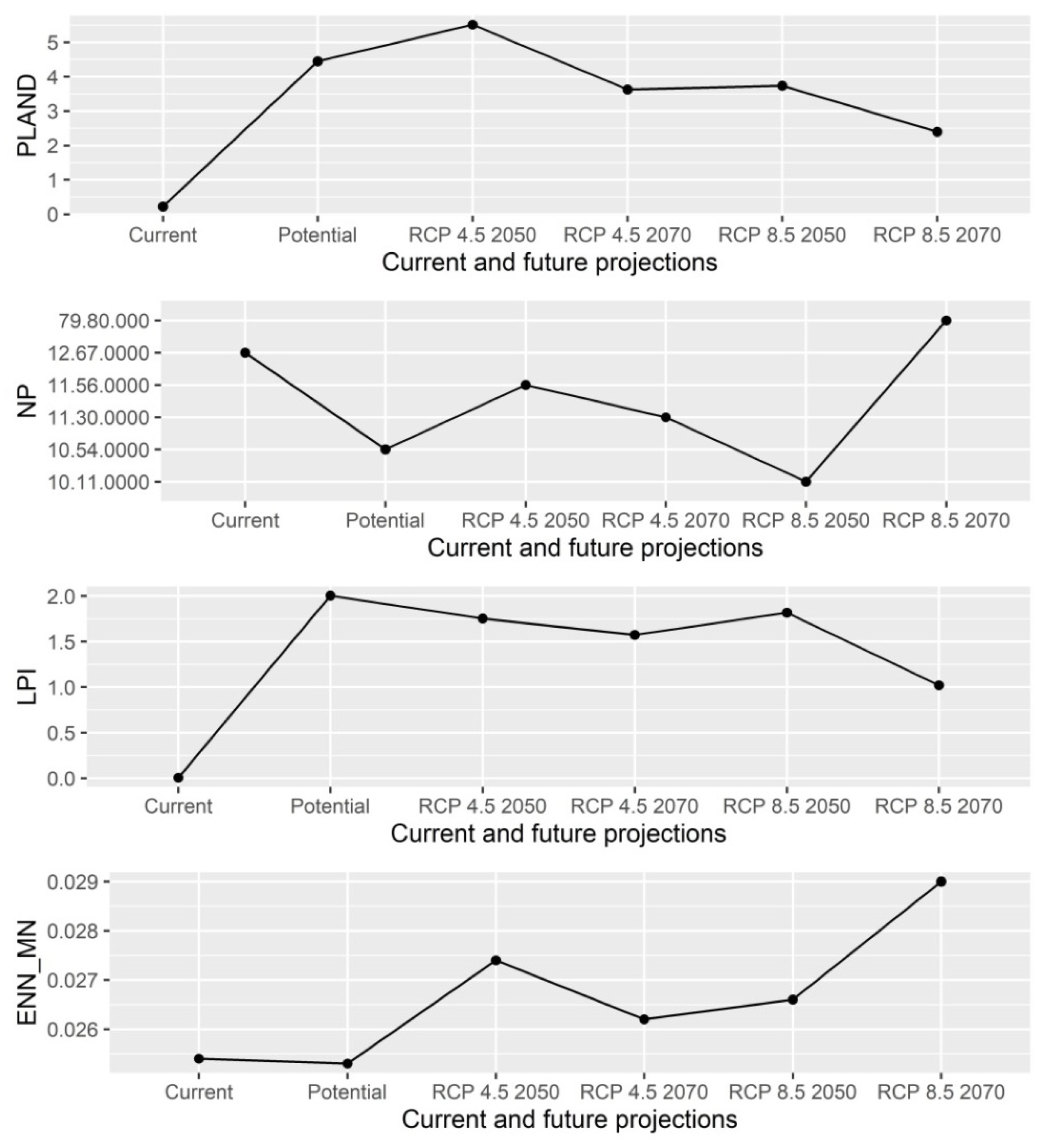
In the second phase of the study, the distribution of the species was mapped using an up-to-date digital stand map of the species. The present-time distribution of the species needs to be examined in order to be able to make comparisons with its future distribution and habitat connectivity. The present-time and future potential distribution area maps were converted into binary data. Landscape analyses based on habitat connectivity were carried out on GuidosToolbox (version 3.0), which is a holistic platform for analysing the composition, connectivity, and fragmentation of habitats independent of the specific responses of different species [94]. Morphological spatial pattern analysis (MSPA) was used to measure the structure and composition of the ecological network across the landscape in the study area. MSPA is a specialised set of morphological operators that aim to define the geometry and connectivity of image components. It offers a practical and useful method for assessing structural connectivity, categorising the areas occupied by an ecosystem into diverse structural classes such as cores, islets, bridges, and edges [95]. GuidosToolbox (Graphical User Interface for the Description of image Objects and their Shapes) has been frequently used when making use of MSPA in recent years [96,97] since it provides a practical digital image analysis in order to identify the effects of land usage policies and land management practises on natural landscapes consisting of forest areas and to determine the hotspots of regional-scale changes. Based solely on geometric concepts, MSPA can be applied to any type of digital image on any scale in any application area. The foreground area of the binary image is divided into seven visually distinguished MSPA classes (core, islet, perforation, edge, loop, bridge, and branch). MSPA segmentation results in 25 feature classes, which correspond fully to the first foreground area when combined. Since most microclimatic and biophysical parameters of forests (i.e., temperature, humidity, shade, radiation) tend to be affected by edge effects up to 5 m from the edge of the forest, the margin width in the MSPA was set to 3 m (or 2 pixels) [98]. In the final stage of the study, the historical and recent changes in habitat connectivity and their likely future changes within the framework of climate scenarios were examined with transition matrices using the lulc [99] R package. In order to observe the direction of the changes, the change in area between habitat units was visualised using a Sankey diagram. The height of each component in the columns denoting the units in the Sankey diagram is proportional to the relative abundance of the MSPA category represented within the study area. These categories were arranged (vertically) in descending order of size, based on their spatial dimensions. The thickness of the lines between the columns, which shows the units between which the change has occurred, is important for understanding the degree of change. An increase in line thickness indicates that the amount of connectivity has increased.
To quantify the extent and connectivity of the predicted suiThabitats, both current and future, use was made of landscape pattern analysis in FRAGSTATS [100]. Four landscape metrics were calculated for the predicted binary suitable habitats, namely, the percentage of the landscape (PLAND), the largest patch index (LPI), the number of patches (NP), and the Euclidean Nearest Neighbour Distance (ENN). These measures of landscape composition (PLAND and ENN) and configuration (NP and LPI) indicate the extent, fragmentation, and connectivity of habitats under the influence of climate change [100].

3. Results

A total of 396 candidate models were performed and evaluated them in terms of statistical significance (partial ROC < 0.05), good performance (%5 OR = 0.052), and low complexity (AICc = 4660.284). The best model selected linear and quadratic features with 0.1 regularisation multipliers and a mean high AUC for training data (AUC = 0.961, 0.02). The six bioclimatic variables were used to predict the distribution of the target species. According to the model, these variables are the following: precipitation of the driest month (BIO14, 30.7%); minimum temperature of the coldest month (BIO6, 29.4%); precipitation of the wettest month (BIO13, 19.6%); isothermality (BIO3, 15.2%), and temperature seasonality (BIO4, 5.1%). The precipitation in the summer month (BIO14) and the minimum temperature across the winter month (BIO6) were the highest contributions of the model, while the lowest contribution was from temperature seasonality (BIO4). The present-time distribution model indicated that the western, central, and eastern Taurus Mountains have higher habitat suitability for the cedar (Figure 2). According to the future projections, it is predicted that the potential habitat suitability of the species will shrink significantly and that, in the case of pessimistic scenarios, the extent of the suitable habitats will decrease, particularly in the western and central Taurus Mountain chains.
The map showing the current distribution of MSPA classes illustrates that core areas are distributed mainly in the western part of the study area. Islets are predominantly distributed along the Taurus Mountains. The potential distribution and RCP4.5-2050 maps in Figure 3 indicate that almost all large-sized cores are distributed in the central, western, eastern, and south-eastern parts of the Taurus Mountains. On the contrary, the central and western parts include far fewer and smaller core areas for the RCP4.5-2070, RCP8.5-2050, and RCP8.5-2070, notwithstanding the existence of large numbers of corridors (bridges, loops, and branches) and islets. The medium-sized cores are mostly distributed around the large-sized cores.
The “core” is the most observed morphological type for the potential and future distribution of the species (Table 1). The total extent of the core areas for the species in the potential distribution makes up 54.68 per cent of the study area. This percentage varies from 59.9 per cent under the RCP4.5-2050 to 50.12 per cent under the RCP4.5-2070, 53.59 per cent under the RCP8.5-2050 and 52.3 per cent according to the RCP8.5-2070.
The results show that the species may shift towards the north and that, by comparison with the potential core areas, there will be a slight increase in core areas under the RCP4.5-2050 scenario, while core areas will decrease under the RCP4.5-2070, RCP8.5-2050, and RCP8.5-2070 scenarios. Bridges are predicted to increase in RCP4.5-2070 and RCP8.5-2050 but to decrease in other scenarios. As the cedar is currently distributed in the form of islets, it is natural for the islet category to cover 67.66 per cent of the area. This percentage falls to only 4.38 per cent in the map of potential distribution and increases relatively again to reach 7.59 per cent in the RCP8.5-2070 scenario. The percentage values for perforation areas vary between 0 per cent and 1.27 per cent. While the percentages for perforation amount are low, the extent of edges shows a significant increase when compared to current values. The increase in edges shows that the species will not be able to avoid the edge effect of core areas even if they are not exposed to perforation. The loop and branch values were observed to be very close to one another.
According to the results of the landscape metrics, while PLAND is 0.224 in the current distribution of the species, it is 4.450 in the potential distribution of the species, 5.508 in the RCP4.5-2050 scenario, 3.626 in the RCP4.5-2070 scenario, 3.734 in the RCP8.5-2050 scenario, and 2.393 in the RCP8.5-2070 scenario (Appendix A [Figure A1]). The NP values show a significant decrease between the current and future scenarios. Although NP increases in the potential distribution and in the RCP4.5-2050 scenario, this increase is still lower than the NP value in the current distribution of the species. Decreases were also observed in the NP values for other periods. While the NP value for the current distribution of the species is 12.67.0000, it is 10.54.0000 according to the potential distribution of the species, 11.56.0000 according to the RCP4.5-2050, 11.30.0000 according to the RCP4.5-2070, 10.11.0000 according to the RCP8.5-2050, and 79.80.0000 according to the RCP-8.5-2070.
The LPI values vary from 0.007 to 2.004. While the LPI value is at its highest in the potential distribution of the species, it decreases by almost half (1.023) under the RCP8.5-2070. In the RCP4.5-2050 and RCP8.5-2050, the LPI values (1.754 and 1.817, respectively) are slightly higher than the LPI values in the current distribution (0.007) and in the RCP4.5-2070 scenario (1.574). The ENN_MN value is lowest in the current distribution (0.0254) and highest in the RCP8.5-2070. ENN_MN values increase between the potential distribution and the RCP4.5-2050 and decrease between the RCP4.5-2050 and the RCP4.5-2070.
When the structural elements in the potential distribution of the species and the RCP4.5-2050 are compared using Sankey diagrams, it is predicted that there will be transformations from core areas to other linear elements (edges, bridges, branches, or loops) (Figure 4). The most striking change is the trade-off between cores and edges. While it is expected that a significant amount of core areas will turn into edges, it is also likely that a large portion of edges will turn into cores. The transition of structural elements between the RCP4.5-2050 and RCP4.5-2070 is somewhat similar to the transition of structural elements between the potential distribution of the species and the RCP4.5-2050. The main difference is that the number of core areas transformed will be less between the RCP4.5-2050 and the RCP4.5-2070. When the structural elements in the potential distribution of the species are compared with the RCP8.5-2050, it is predicted that the core areas will turn more into edges and bridges. The narrowing of the vertical columns in the Sankey diagram between the RCP8.5-2050 and RCP8.5-2070 is due to the smaller amount of changing core areas. It is likely that core areas will turn more into edges and islets between these two scenarios. Transition matrices showing the percentages of the landscape that undergoes change for each of the possible combinations of MSPA categories for current and future projections are given in Appendix A (Table A1).

4. Discussion

Climate change is an imminent threat to biodiversity, which may increase the risk of extinction for many species. Management actions taking into account future climate and land-use changes are necessary to mitigate the effects of global environmental changes [101]. This study focuses on the impact of climate change on future Lebanon cedars. However, human activities, such as ecological engineering, deforestation, and land-use change, can also influence its pattern to a certain extent. Therefore, further study may consider potential environmental changes in ecological niche modelling in addition to the changing climate conditions.
In this study, we focused not on forest fragmentation but on the changes in the distribution of the cedar as a specific species. It is possible to predict that the potential forest area will expand as the upper limit of the forest rises with the increase in temperature. It is clear that the mountainous areas of the Mediterranean coastline will be greatly affected by climate change. It has been predicted that the areas populated by the red pine (Pinus brutia) and black pine (P. nigra), which are the dominant tree species along the Mediterranean coastline and are very widely distributed, will expand towards the mountain summits [102,103,104,105]. Both global warming and competition from the dominant species will tend to push species found in the upper forest border, such as the fir (Abies cilicica) and Lebanon cedar, up against the mountain peaks. It is generally acknowledged that ecosystems such as mountains, which have “no place to go”, face greater threats as temperatures rise [106,107].
MSPA analysis results revealed the connectivity of cedar patches. The absence of landscape connections may lead to the isolation of habitat patches, affecting pollination, seed distribution, and gene flow, in addition to other ecological processes. Increasing connectivity provides species with an increased ability to move to new regions in the face of climate change, which in turn reduces the likelihood or possibility of extinction [108,109]. In other words, high connectivity provides the species only with the potential to spread to places with temperatures that are similar to those they experience today [110]. For this reason, increasing connectivity may increase the likelihood that many organisms will survive as the climate changes. Connectivity is a functional parameter; it depends not only on the structure of the landscape but also on the behaviour of organisms and their capacity to spread out [111]. For this reason, priority should be attached to making use of the connection points between existing cedar cores that have been identified. Another factor in connectivity is islets. Islets represent isolated patches that are not wide enough to contain cores and therefore do not display clear edges either [112]. A large number of islets in the current situation will play a particularly important role in the distribution of species. Islets play a significant role in the connectivity of C. libani, making it necessary to plan the increase in their patch edges and to improve their connectivity by means of new corridors. The MSPA analysis yielded very different results for core areas and islets in the current cedar forests than in the projected potential and future distributions of the cedar forest. There may be several important reasons why the cedar cores are spatially smaller and more in the form of islets under current conditions. The first of these relates to the difference between fundamental niches and realised niches in the Grinnellian concept of niches [113,114], which determines the distribution of a species under ideal conditions [115]. After all, when determining the potential distribution areas of a species, species distribution models assume that the species has uninterrupted access to resources [115] and may overlook many variables such as competition and delimiters [77]. Secondly, the cedar is distributed in a scattered manner in its natural distribution area [68]. The third important reason is the fact that the pixel value of the raster data scale representing the current situation is low (10 m), while the pixel values of the potential and future projection maps are higher (1 km) due to the specifications of the bio-climatic data set. The higher resolution will always provide the most accurate result. As the spatial resolution of the mapping increases, the percentage of the surface area classified as cores in each of the layers will decrease [116]. All these three reasons combined in the MSPA analyses contribute to the finding that islets cover a greater area in the current situation.
The future projections of the study indicate that there will be a general expansion by comparison with the potential distribution, that the cedar areas in the western Taurus Mountains will decrease and become more fragmented, but that the cedar areas in the central Taurus Mountains will expand, and that a shift will take place due to the expansion of these areas towards the eastern Taurus Mountains. López-Tirado et al. [60] predict that the areas inhabited by the cedar will expand in the future under all climate scenarios. However, there are differences in most of the predicted areas. It should be underlined that [60] addresses the potential distribution of the cedar and includes afforestation areas as a set of data in their study as well as where the species is distributed naturally. The most prominent finding of all the future projections and in the MSPA analysis is that the cedar forests in the eastern, central, and western parts of the Taurus Mountains will become less attached to one another. The most important reason for this is related to the valleys formed by the rivers Aksu and Göksu, which extend furthest into the Taurus Mountains from the sea. These two valleys already form one of the most important areas in terms of the change in cedar units. The cedar is represented by two different units in the Taurus Mountains, namely, the cedar forests (Abieti-Cedrion) of the central and eastern Taurus chains and the cedar forests (Lonicero-Cedrion) of the western Taurus chains [58]. The Lonicero-Cedrion units in the western area will clearly face higher risks. In the eastern part of the Taurus Mountains in particular, the cedar’s core areas are increasing and, more importantly, shifting en masse towards the Anatolian diagonal. The Anatolian diagonal was of key importance in the spread of plants from north to south, or vice versa, during the global climate crises that occurred both in the ice age and the Holocene (Cainozoic) [117]. The Anatolian Diagonal overlaps with the geographical limits of the distributions of various populations and taxa [118]. Declining distribution areas and shifts in ranges may create new shelter areas where endangered species will concentrate in the future [119]. These results show that the Anatolian Diagonal will regain its function both as a shelter and as a bridge due to global warming.
There is a strong relationship between the configuration metrics of a habitat and its extent [120]. According to landscape ecologists, forests, which occupy a large place among natural ecosystems, are likely to include a wider variety of habitats. A wider range of species can emerge in large and uninterrupted (continuous) forests. This is because wider areas generally have a regional pool of species. For this reason, many studies have noted that forest fragmentation leads to decreasing biodiversity [121]. Although the present study does not focus directly on the effects of fragmentation on biodiversity, it is predicted that fragmentation will damage habitat areas over time.
Our finding that, in the wider scheme of things, the core areas of the cedar will expand in the future, but that this expansion will take place mostly in the form of shifts, is important. One of the three most striking points from the results of this study that call out for attention is the question of how far the shifts in a range will occur towards the Anatolian Diagonal in the eastern Taurus Mountains. Cedar can potentially move along the current natural landscape configuration, which will take place and whether the distance is suitable enough to follow the predicted temperature changes. If the speed of change exceeds the biological response speed, then this may have serious effects, particularly on the capacity of the populations’ capacity to migrate or undergo adaptive evolutionary change, and on their distributions, community structures, and ecosystem functions [122]. It will therefore be quite difficult for the species to settle naturally in the areas made available by shifts of up to 100 km in a period of 80 years. Of course, abiotic factors and other competitive tree species should also be taken into account. The forestry sector, with its long production cycles, will have to deal with severe challenges in the face of climate change [123]. Aside from the many ecosystem services it provides, the cedar is the most economically valuable forest tree in Turkey. This has been the case for approximately 5000 years [124], and it will probably remain so in the future. For this reason, the Lebanon cedar is the species most frequently used outside its natural range for afforestation for commercial forestry purposes in Turkey, reflecting its adaptability, its high survival rate and the unique properties of its wood [56,58,124,125]. Leaving such a valuable species to take its natural course could result in considerable economic losses. In this respect, the output of the present study has been to identify, for the use of forest managers and planners, those areas where the natural process can be accelerated. It may be particularly necessary to support the core and connectivity areas identified here with seeding or afforestation techniques. The second important point from the results of this study that calls for attention in terms of forestry is the anticipated shrinkage of core areas and the detachments that are predicted to occur in the western Taurus Mountain chain. Of course, this shrinkage and breakage will affect not only the cedar but also other plants that form part of the Lonicero-Cedrion association and may pave the way for the formation of new units. Silvicultural interventions that eliminate competition may gain importance in the western Taurus Mountain chains rather than afforestation. From a different perspective, planners and managers should check the right option using the analytical tools available in project management. At this point, managers must also be aware of the consequences of their actions and anticipate the extent of future events. It is known that prediction is as important as a diagnosis in conservation. The main challenge in decision making is to explore the reasonable future scope that will arise when different solutions become available under conditions of uncertainty and complexity [126]. Therefore, the need to use project management tools (e.g., decision-making, cost-benefit analyses) and monitoring approaches (DPSIR, BACI, etc.) should be determined carefully.

5. Conclusions

In this study, the changes in the current, potential, and future connectivity of the Lebanon cedar were predicted by the integration of the ecological niche model with the ecological connectivity approach. As a result, the ecological connectivity of cedar will change under different scenarios. There will be breakages in cedar connectivity, while on the other hand, new connections will be formed. Although the landscape metrics vary depending on the climate scenario, they show that PLAND will decrease by 2070 and NP will increase. A decline in LPI and a rise in ENN_MN will make fragmentation inevitable. The conservation should be initiated as a function of forest planning in order to prevent the fragmentation of cedar habitats in the future, and the findings of this study should be used as a guide in forest management in Turkey. Although modelling the future distribution of species under the influence of climate change is a common topic in contemporary research, only a limited number of studies have sought answers to the question of what will happen in terms of ecological connectivity. This study emphasises that the consequences of future climate change should be taken into account while planning ecological connectivity from now on. The use of project management tools should comprise the integrated approaches presented in this paper to make robust decisions in forest planning.

Author Contributions

Conceptualization, A.U.Ö.; methodology, D.G., A.U.Ö. and J.V.; software, K.Ç. and D.G.; analysis, K.Ç. and D.G.; investigation, V.R.; resources, A.U.Ö. and K.Ç.; data curation, A.U.Ö., K.Ç. and D.G.; writing—original draft preparation, A.U.Ö., J.V., V.R., D.G. and K.Ç.; writing—review and editing A.U.Ö., J.V., D.G, V.R. and K.Ç, the anonymous reviewers and the editor.; visualization, D.G.; supervision, J.V.; project administration, A.U.Ö. and D.G. All authors have read and agreed to the published version of the manuscript.

Funding

This research received no external funding.

Data Availability Statement

The data of the current research is available from the corresponding author on request.

Acknowledgments

We would like to thank the anonymous reviewers and the editor for their careful reading and valuable comments.

Conflicts of Interest

The authors declare no conflict of interest.

Appendix A

Figure A1. Landscape metrics (PLAND, NP, LPI, and ENN_MN) results for current and future projections.
Land 11 00802 g0a1
Table A1. Transition matrices showing the proportion of the landscape, in percentage that undergoes change for each of the potential combinations of MSPA categories for current and future projections.
Potential-RCP 4.5 2050
BackgroundCoreIsletPerforationEdgeLoopBridgeBranch
Background97.491.380.140.020.370.190.180.23
Core14.8757.481.450.3313.534.934.243.16
Islet60.2713.9510.860.096.642.461.753.97
Perforation1.3787.811.550.773.091.204.210.00
Edge48.6315.073.730.0517.402.353.299.49
Loop45.7025.633.040.0711.574.202.487.32
Bridge32.1632.613.410.4715.444.714.087.13
Branch70.549.294.590.054.291.441.298.51
Potential-RCP 4.5 2070
Background98.380.960.090.010.210.110.140.10
Core42.7525.763.840.1910.183.858.694.75
Islet77.066.666.440.035.412.010.711.67
Perforation9.6165.320.262.838.761.7210.990.52
Edge69.1010.174.210.046.701.333.085.38
Loop63.9118.613.670.204.541.963.183.95
Bridge50.5320.122.100.1412.263.895.365.60
Branch82.596.972.310.023.250.621.462.78
Potential-RCP 8.5 2050
BackgroundCoreIsletPerforationEdgeLoopBridgeBranch
Background98.101.200.070.020.240.110.140.13
Core47.9923.483.150.098.434.178.504.19
Islet78.428.643.120.006.001.200.901.72
Perforation16.3156.650.170.865.840.8618.281.03
Edge71.829.943.460.015.721.143.374.53
Loop66.6118.303.480.134.490.793.262.93
Bridge49.1322.572.280.0112.453.644.835.09
Branch82.127.581.920.013.230.871.362.91
Potential-RCP 8.5 2070
BackgroundCoreIsletPerforationEdgeLoopBridgeBranch
Background98.510.870.100.010.210.070.110.12
Core75.8010.112.240.005.041.701.793.33
Islet89.942.721.630.002.450.830.541.89
Perforation38.2840.091.030.008.841.378.242.15
Edge85.316.091.230.003.830.860.881.80
Loop77.4112.641.330.004.621.201.661.13
Bridge70.3411.962.460.006.832.191.744.48
Branch89.915.180.840.002.250.420.570.83

References

  1. Garcia, C.A.; Savilaakso, S.; Verburg, R.W.; Gutierrez, V.; Wilson, S.J.; Krug, C.B.; Sassen, M.; Robinson, B.E.; Moersberger, H.; Naimi, B.; et al. The Global Forest Transition as a Human Affair. One Earth 2020, 2, 417–428. [Google Scholar] [CrossRef]
  2. Keenan, R.J.; Reams, G.A.; Achard, F.; de Freitas, J.V.; Grainger, A.; Lindquist, E. Dynamics of Global Forest Area: Results from the FAO Global Forest Resources Assessment 2015. For. Ecol. Manag. 2015, 352, 9–20. [Google Scholar] [CrossRef]
  3. IPCC. Climate Change 2014: Synthesis Report. Contribution of Working Groups I, II and III to the Fifth Assessment Report of the Intergovernmental Panel on Climate Change; IPCC: Geneva, Switzerland, 2014; p. 151. [Google Scholar]
  4. Zhang, B.; Brack, C.L. Urban Forest Responses to Climate Change: A Case Study in Canberra. Urban For. Urban Green. 2021, 57, 126910. [Google Scholar] [CrossRef]
  5. O’Neill, B.C.; Oppenheimer, M.; Warren, R.; Hallegatte, S.; Kopp, R.E.; Pörtner, H.O.; Scholes, R.; Birkmann, J.; Foden, W.; Licker, R.; et al. IPCC Reasons for Concern Regarding Climate Change Risks. Nat. Clim. Chang. 2017, 7, 28–37. [Google Scholar] [CrossRef] [Green Version]
  6. Robinson, S. Climate Change Adaptation in SIDS: A Systematic Review of the Literature Pre and Post the IPCC Fifth Assessment Report. WIREs Clim. Chang. 2020, 11, e653. [Google Scholar] [CrossRef]
  7. Walther, G.-R.; Post, E.; Convey, P.; Menzel, A.; Parmesan, C.; Beebee, T.J.C.; Fromentin, J.M.; Hoegh-Guldberg, O.; Bairlein, F. Ecological Responses to Recent Climate Change. Nature 2002, 416, 389–395. [Google Scholar] [CrossRef]
  8. Estrada-Contreras, I.; Equihua, M.; Laborde, J.; Meyer, E.M.; Sánchez-Velásquez, L.R. Current and Future Distribution of the Tropical Tree Cedrela odorata L. in Mexico under Climate Change Scenarios Using MaxLike. PLoS ONE 2016, 11, e0164178. [Google Scholar] [CrossRef]
  9. Klein, T.; Cahanovitc, R.; Sprintsin, M.; Herr, N.; Schiller, G. A Nation-Wide Analysis of Tree Mortality under Climate Change: Forest Loss and Its Causes in Israel 1948–2017. For. Ecol. Manag. 2019, 432, 840–849. [Google Scholar] [CrossRef]
  10. Luo, Y.; Chen, H.Y.H. Observations from Old Forests Underestimate Climate Change Effects on Tree Mortality. Nat. Commun. 2013, 4, 1655. [Google Scholar] [CrossRef]
  11. Garrett, K.A.; Dendy, S.P.; Frank, E.E.; Rouse, M.N.; Travers, S.E. Climate Change Effects on Plant Disease: Genomes to Ecosystems. Annu. Rev. Phytopathol. 2006, 44, 489–509. [Google Scholar] [CrossRef] [Green Version]
  12. Sturrock, R.N.; Frankel, S.J.; Brown, A.V.; Hennon, P.E.; Kliejunas, J.T.; Lewis, K.J.; Worrall, J.J.; Woods, A.J. Climate Change and Forest Diseases. Plant Pathol. 2011, 60, 133–149. [Google Scholar] [CrossRef]
  13. Bakkenes, M.; Alkemade, J.R.M.; Ihle, F.; Leemans, R.; Latour, J.B. Assessing Effects of Forecasted Climate Change on the Diversity and Distribution of European Higher Plants for 2050. Glob. Chang. Biol. 2002, 8, 390–407. [Google Scholar] [CrossRef]
  14. Thuiller, W. Climate Change and the Ecologist. Nature 2007, 448, 550–552. [Google Scholar] [CrossRef] [PubMed]
  15. Dolezal, J.; Jandova, V.; Macek, M.; Mudrak, O.; Altman, J.; Schweingruber, F.H.; Liancourt, P. Climate Warming Drives Himalayan Alpine Plant Growth and Recruitment Dynamics. J. Ecol. 2020, 109, 179–190. [Google Scholar] [CrossRef]
  16. Wang, H.; Liu, H.; Cao, G.; Ma, Z.; Li, Y.; Zhang, F.; Zhao, X.; Zhao, X.; Jiang, L.; Sanders, N.J.; et al. Alpine Grassland Plants Grow Earlier and Faster but Biomass Remains Unchanged over 35 Years of Climate Change. Ecol. Lett. 2020, 23, 701–710. [Google Scholar] [CrossRef] [Green Version]
  17. Ammer, C. Diversity and Forest Productivity in a Changing Climate. New Phytol. 2018, 221, 50–66. [Google Scholar] [CrossRef] [Green Version]
  18. Boisvenue, C.; Running, S.W. Impacts of Climate Change on Natural Forest Productivity—Evidence since the Middle of the 20th Century. Glob. Chang. Biol. 2006, 12, 862–882. [Google Scholar] [CrossRef]
  19. Morin, X.; Fahse, L.; Jactel, H.; Scherer-Lorenzen, M.; García-Valdés, R.; Bugmann, H. Long-Term Response of Forest Productivity to Climate Change Is Mostly Driven by Change in Tree Species Composition. Sci. Rep. 2018, 8, 5627. [Google Scholar] [CrossRef] [Green Version]
  20. Varol, T.; Cetin, M.; Ozel, H.B.; Sevik, H.; Zeren Cetin, I. The Effects of Climate Change Scenarios on Carpinus betulus and Carpinus orientalis in Europe. Water Air Soil Pollut. 2022, 233, 45. [Google Scholar] [CrossRef]
  21. Dyderski, M.K.; Paź, S.; Frelich, L.E.; Jagodziński, A.M. How Much Does Climate Change Threaten European Forest Tree Species Distributions? Glob. Chang. Biol. 2018, 24, 1150–1163. [Google Scholar] [CrossRef]
  22. Naudiyal, N.; Wang, J.; Ning, W.; Gaire, N.P.; Peili, S.; Yanqiang, W.; Jiali, H.; Ning, S. Potential Distribution of Abies, Picea, and Juniperus Species in the Sub-Alpine Forest of Minjiang Headwater Region under Current and Future Climate Scenarios and Its Implications on Ecosystem Services Supply. Ecol. Indic. 2021, 121, 107131. [Google Scholar] [CrossRef]
  23. Rashid, I.; Romshoo, S.A. Impact of Climate Change on Vegetation Distribution in the Kashmir Himalaya. In Biodiversity of the Himalaya: Jammu and Kashmir State; Dar, G.H., Khuroo, A.A., Eds.; Topics in Biodiversity and Conservation; Springer: Singapore, 2020; pp. 1029–1047. ISBN 978-981-329-174-4. [Google Scholar]
  24. Zhang, Y.; Liang, W.; Liao, Z.; Han, Z.; Xu, X.; Jiao, R.; Liu, H. Effects of Climate Change on Lake Area and Vegetation Cover over the Past 55 Years in Northeast Inner Mongolia Grassland, China. Theor. Appl. Climatol. 2019, 138, 13–25. [Google Scholar] [CrossRef]
  25. Fekete, I.; Lajtha, K.; Kotroczó, Z.; Várbíró, G.; Varga, C.; Tóth, J.A.; Demeter, I.; Veperdi, G.; Berki, I. Long-Term Effects of Climate Change on Carbon Storage and Tree Species Composition in a Dry Deciduous Forest. Glob. Chang. Biol. 2017, 23, 3154–3168. [Google Scholar] [CrossRef] [PubMed]
  26. Lenihan, J.M.; Drapek, R.; Bachelet, D.; Neilson, R.P. Climate Change Effects on Vegetation Distribution, Carbon, and Fire in California. Ecol. Appl. 2003, 13, 1667–1681. [Google Scholar] [CrossRef]
  27. Iverson, L.R.; Thompson, F.R.; Matthews, S.; Peters, M.; Prasad, A.; Dijak, W.D.; Fraser, J.; Wang, W.J.; Hanberry, B.; He, H.; et al. Multi-Model Comparison on the Effects of Climate Change on Tree Species in the Eastern U.S.: Results from an Enhanced Niche Model and Process-Based Ecosystem and Landscape Models. Landsc. Ecol. 2017, 32, 1327–1346. [Google Scholar] [CrossRef]
  28. Morin, X.; de Coligny, F.; Martin-StPaul, N.; Bugmann, H.; Cailleret, M.; Limousin, J.M.; Ourcival, J.M.; Prevosto, B.; Simioni, G.; Vennetier, M.; et al. Beyond Forest Succession: A Gap Model to Study Ecosystem Functioning and Tree Community Composition under Climate Change. Funct. Ecol. 2021, 35, 955–975. [Google Scholar] [CrossRef]
  29. Wang, W.J.; He, H.S.; Thompson, F.R.; Fraser, J.S.; Dijak, W.D. Changes in Forest Biomass and Tree Species Distribution under Climate Change in the Northeastern United States. Landsc. Ecol. 2017, 32, 1399–1413. [Google Scholar] [CrossRef]
  30. Alagador, D.; Cerdeira, J.O.; Araújo, M.B. Shifting Protected Areas: Scheduling Spatial Priorities under Climate Change. J. Appl. Ecol. 2014, 51, 703–713. [Google Scholar] [CrossRef]
  31. Cerrejón, C.; Valeria, O.; Mansuy, N.; Barbé, M.; Fenton, N.J. Predictive Mapping of Bryophyte Richness Patterns in Boreal Forests Using Species Distribution Models and Remote Sensing Data. Ecol. Indic. 2020, 119, 106826. [Google Scholar] [CrossRef]
  32. Li, G.; Xiao, N.; Luo, Z.; Liu, D.; Zhao, Z.; Guan, X.; Zang, C.; Li, J.; Shen, Z. Identifying Conservation Priority Areas for Gymnosperm Species under Climate Changes in China. Biol. Conserv. 2021, 253, 108914. [Google Scholar] [CrossRef]
  33. Dinerstein, E.; Joshi, A.R.; Vynne, C.; Lee, A.T.L.; Pharand-Deschênes, F.; França, M.; Fernando, S.; Birch, T.; Burkart, K.; Asner, G.P.; et al. A “Global Safety Net” to Reverse Biodiversity Loss and Stabilize Earth’s Climate. Sci. Adv. 2020, 6, eabb2824. [Google Scholar] [CrossRef] [PubMed]
  34. Wang, R.; Yang, H.; Luo, W.; Wang, M.; Lu, X.; Huang, T.; Zhao, J.; Li, Q. Predicting the Potential Distribution of the Asian Citrus Psyllid, Diaphorina citri (Kuwayama), in China Using the MaxEnt Model. PeerJ 2019, 7, e7323. [Google Scholar] [CrossRef] [PubMed] [Green Version]
  35. Du, Z.; He, Y.; Wang, H.; Wang, C.; Duan, Y. Potential Geographical Distribution and Habitat Shift of the Genus Ammopiptanthus in China under Current and Future Climate Change Based on the MaxEnt Model. J. Arid Environ. 2021, 184, 104328. [Google Scholar] [CrossRef]
  36. Rana, S.K.; Rana, H.K.; Luo, D.; Sun, H. Estimating Climate-Induced ‘Nowhere to Go’ Range Shifts of the Himalayan Incarvillea Juss. Using Multi-Model Median Ensemble Species Distribution Models. Ecol. Indic. 2020, 121, 107127. [Google Scholar] [CrossRef]
  37. Yi, Y.J.; Cheng, X.; Yang, Z.F.; Zhang, S.H. Maxent Modeling for Predicting the Potential Distribution of Endangered Medicinal Plant (H. riparia Lour) in Yunnan, China. Ecol. Eng. 2016, 92, 260–269. [Google Scholar] [CrossRef]
  38. Yesuf, G.U.; Brown, K.A.; Walford, N.S.; Rakotoarisoa, S.E.; Rufino, M.C. Predicting Range Shifts for Critically Endangered Plants: Is Habitat Connectivity Irrelevant or Necessary? Biol. Conserv. 2021, 256, 109033. [Google Scholar] [CrossRef]
  39. Lindenmayer, D.B.; Fischer, J. Tackling the Habitat Fragmentation Panchreston. Trends Ecol. Evol. 2007, 22, 127–132. [Google Scholar] [CrossRef]
  40. Kramer, R.D.; Ishii, H.R.; Carter, K.R.; Miyazaki, Y.; Cavaleri, M.A.; Araki, M.G.; Azuma, W.A.; Inoue, Y.; Hara, C. Predicting Effects of Climate Change on Productivity and Persistence of Forest Trees. Ecol. Res. 2020, 35, 562–574. [Google Scholar] [CrossRef]
  41. Taleshi, H.; Jalali, S.G.; Alavi, S.J.; Hosseini, S.M.; Naimi, B.; Zimmermann, N.E. Climate Change Impacts on the Distribution and Diversity of Major Tree Species in the Temperate Forests of Northern Iran. Reg. Environ. Chang. 2019, 19, 2711–2728. [Google Scholar] [CrossRef]
  42. Norberg, A.; Abrego, N.; Blanchet, F.G.; Adler, F.R.; Anderson, B.J.; Anttila, J.; Araújo, M.B.; Dallas, T.; Dunson, D.; Elith, J.; et al. A Comprehensive Evaluation of Predictive Performance of 33 Species Distribution Models at Species and Community Levels. Ecol. Monogr. 2019, 89, e01370. [Google Scholar] [CrossRef]
  43. Peterson, A.T.; Soberón, J.; Pearson, R.G.; Anderson, R.P.; Martínez-Meyer, E.; Nakamura, M.; Araújo, M.B. Ecological Niches and Geographic Distributions (MPB-49); Princeton University Press: Princeton, NJ, USA, 2011; ISBN 978-1-4008-4067-0. [Google Scholar]
  44. Prasad, A.; Pedlar, J.; Peters, M.; McKenney, D.; Iverson, L.; Matthews, S.; Adams, B. Combining US and Canadian Forest Inventories to Assess Habitat Suitability and Migration Potential of 25 Tree Species under Climate Change. Divers. Distrib. 2020, 26, 1142–1159. [Google Scholar] [CrossRef]
  45. Tumas, H.R.; Shamblin, B.M.; Woodrey, M.; Nibbelink, N.P.; Chandler, R.; Nairn, C. Landscape Genetics of the Foundational Salt Marsh Plant Species Black Needlerush (Juncus roemerianus Scheele) across the Northeastern Gulf of Mexico. Landsc. Ecol. 2018, 33, 1585–1601. [Google Scholar] [CrossRef] [Green Version]
  46. De Oliveira-Junior, N.D.; Heringer, G.; Bueno, M.L.; Pontara, V.; Meira-Neto, J.A.A. Prioritizing Landscape Connectivity of a Tropical Forest Biodiversity Hotspot in Global Change Scenario. For. Ecol. Manag. 2020, 472, 118247. [Google Scholar] [CrossRef]
  47. Günal, N. The Effects of the Climate on the Natural Vegetation in Turkey. Acta Turc. Çevrimiçi Temat. Türkol. Derg. 2013, 1, 1–22. [Google Scholar]
  48. Pecl, G.T.; Araújo, M.B.; Bell, J.D.; Blanchard, J.; Bonebrake, T.C.; Chen, I.-C.; Clark, T.D.; Colwell, R.K.; Danielsen, F.; Evengård, B.; et al. Biodiversity Redistribution under Climate Change: Impacts on Ecosystems and Human Well-Being. Science 2017, 355, eaai9214. [Google Scholar] [CrossRef]
  49. Elsen, P.R.; Monahan, W.B.; Dougherty, E.R.; Merenlender, A.M. Keeping Pace with Climate Change in Global Terrestrial Protected Areas. Sci. Adv. 2020, 6, eaay0814. [Google Scholar] [CrossRef]
  50. Wan, J.Z.; Wang, C.J.; Yu, F.H. Spatial Conservation Prioritization for Dominant Tree Species of Chinese Forest Communities under Climate Change. Clim. Chang. 2017, 144, 303–316. [Google Scholar] [CrossRef]
  51. De Montis, A.; Caschili, S.; Mulas, M.; Modica, G.; Ganciu, A.; Bardi, A.; Ledda, A.; Dessena, L.; Laudari, L.; Fichera, C.R. Urban–Rural Ecological Networks for Landscape Planning. Land Use Policy 2016, 50, 312–327. [Google Scholar] [CrossRef]
  52. Hepcan, Ş.; Hepcan, Ç.C.; Bouwma, I.M.; Jongman, R.H.G.; Özkan, M.B. Ecological Networks as a New Approach for Nature Conservation in Turkey: A Case Study of İzmir Province. Landsc. Urban Plan. 2009, 90, 143–154. [Google Scholar] [CrossRef]
  53. Özcan, A.U.; Erzin, P.E. Assessment of GIS-Assisted Movement Patches Using LCP for Local Species: North Central Anatolia Region, Turkey. Cerne 2020, 26, 130–139. [Google Scholar] [CrossRef]
  54. McRae, B.H.; Hall, S.A.; Beier, P.; Theobald, D.M. Where to Restore Ecological Connectivity? Detecting Barriers and Quantifying Restoration Benefits. PLoS ONE 2012, 7, e52604. [Google Scholar] [CrossRef]
  55. Nor, A.N.M.; Corstanje, R.; Harris, J.A.; Grafius, D.R.; Siriwardena, G.M. Ecological Connectivity Networks in Rapidly Expanding Cities. Heliyon 2017, 3, e00325. [Google Scholar] [CrossRef] [PubMed] [Green Version]
  56. Boydak, M. Regeneration of Lebanon Cedar (Cedrus libani A. Rich.) on Karstic Lands in Turkey. For. Ecol. Manag. 2003, 178, 231–243. [Google Scholar] [CrossRef]
  57. Linares, J.C. Biogeography and Evolution of Abies (Pinaceae) in the Mediterranean Basin: The Roles of Long-Term Climatic Change and Glacial Refugia. J. Biogeogr. 2011, 38, 619–630. [Google Scholar] [CrossRef]
  58. Boydak, M. Ecology, Natural Regeneration and Karst Area Afforestation of Lebanon Cedar. 2. National Mediterranean Forest and En-vironment Symposium, Isparta, Turkey. 2014, p. 25. Available online: http://ormanweb.isparta.edu.tr/ormanvecevre/belgeler/bildiriler/AA-1.pdf (accessed on 20 April 2022).
  59. Hajar, L.; François, L.; Khater, C.; Jomaa, I.; Déqué, M.; Cheddadi, R. Cedrus libani (A. Rich) Distribution in Lebanon: Past, Present and Future. C. R. Biol. 2010, 333, 622–630. [Google Scholar] [CrossRef]
  60. López-Tirado, J.; Vessella, F.; Stephan, J.; Ayan, S.; Schirone, B.; Hidalgo, P.J. Effect of Climate Change on Potential Distribution of Cedrus libani A. Rich in the Twenty-First Century: An Ecological Niche Modeling Assessment. New For. 2021, 52, 363–376. [Google Scholar] [CrossRef]
  61. Arar, A.; Nouidjem, Y.; Bounar, R.; Tabet, S.; Kouba, Y. Modeling of the Current and Future Potential Distribution of Atlas Cedar (Cedrus atlantica) Forests Revealed Shifts in the Latitudinal, Longitudinal and Altitudinal Range towards More Humid Conditions. Ecol. Quest. 2020, 31, 49–62. [Google Scholar] [CrossRef]
  62. Sattout, E.J.; Nemer, N. Managing Climate Change Effects on Relic Forest Ecosystems: A Program for Lebanese Cedar. Biodiversity 2008, 9, 122–130. [Google Scholar] [CrossRef]
  63. Ibrahem, A.; Koubaily, E.; Thabeet, A. Assessment of Suitable Habitat of the Natural Regeneration C. libani A. Richard in Slenfeh (Syria). Egypt. J. Remote Sens. Space Sci. 2021, 24, 163–171. [Google Scholar] [CrossRef]
  64. GDF. State of Turkey’s Forest; General Directorate of Forestry: Ankara, Turkey, 2015. [Google Scholar]
  65. Fick, S.E.; Hijmans, R.J. WorldClim 2: New 1-km Spatial Resolution Climate Surfaces for Global Land Areas. Int. J. Climatol. 2017, 37, 4302–4315. [Google Scholar] [CrossRef]
  66. Atalay, İ. General Ecological Properties of Natural Occurrence Areas of Cedar (Cedrus libani a. Rich) Forests and Regioning of Seed Transfer of Cedar in Turkey; Report of General Directorate of Forestry: Ankara, Turkey, 1987. [Google Scholar]
  67. Kantarcı, D. Cedars of Turkey (Cedrus libani A. Richard) and Some Ecological Relations in Its Natural. J. Fac. for Istanbul U. 1982, 32, 113–198. [Google Scholar]
  68. GDF. Turkey Forestry Statistics; General Directorate of Forestry: Ankara, Turkey, 2020. [Google Scholar]
  69. Beals, E.W. The Remnant Cedar Forests of Lebanon. J. Ecol. 1965, 53, 679–694. [Google Scholar] [CrossRef]
  70. Khuri, S.; Shmoury, M.R.; Baalbaki, R.; Maunder, M.; Talhouk, S.N. Conservation of the Cedrus libani Populations in Lebanon: History, Current Status and Experimental Application of Somatic Embryogenesis. Biodivers. Conserv. 2000, 9, 1261–1273. [Google Scholar] [CrossRef]
  71. Wazen, N.; Garavaglia, V.; Picard, N.; Besacier, C.; Fady, B. Distribution Maps of Twenty-Four Mediterranean and European Ecologically and Economically Important Forest Tree Species Compiled from Historical Data Collections. Ann. Silvic. Res. 2020, 44, 95–101. [Google Scholar] [CrossRef]
  72. Aiello-Lammens, M.E.; Boria, R.A.; Radosavljevic, A.; Vilela, B.; Anderson, R.P. SpThin: An R Package for Spatial Thinning of Species Occurrence Records for Use in Ecological Niche Models. Ecography 2015, 38, 541–545. [Google Scholar] [CrossRef]
  73. Boria, R.A.; Olson, L.E.; Goodman, S.M.; Anderson, R.P. Spatial Filtering to Reduce Sampling Bias Can Improve the Performance of Ecological Niche Models. Ecol. Model. 2014, 275, 73–77. [Google Scholar] [CrossRef]
  74. Fourcade, Y.; Engler, J.O.; Rödder, D.; Secondi, J. Mapping Species Distributions with MAXENT Using a Geographically Biased Sample of Presence Data: A Performance Assessment of Methods for Correcting Sampling Bias. PLoS ONE 2014, 9, e97122. [Google Scholar] [CrossRef] [Green Version]
  75. Merow, C.; Smith, M.J.; Silander, J.A. A Practical Guide to MaxEnt for Modeling Species’ Distributions: What It Does, and Why Inputs and Settings Matter. Ecography 2013, 36, 1058–1069. [Google Scholar] [CrossRef]
  76. Cobos, M.E.; Peterson, A.T.; Barve, N.; Osorio-Olvera, L. Kuenm: An R Package for Detailed Development of Ecological Niche Models Using Maxent. PeerJ 2019, 7, e6281. [Google Scholar] [CrossRef] [Green Version]
  77. Soberón, J.; Nakamura, M. Niches and Distributional Areas: Concepts, Methods, and Assumptions. Proc. Natl. Acad. Sci. USA 2009, 106, 19644–19650. [Google Scholar] [CrossRef] [Green Version]
  78. Soberón, J.; Peterson, A.T. Interpretation of Models of Fundamental Ecological Niches and Species’ Distributional Areas. Biodivers. Inf. 2005, 2, 1–10. [Google Scholar] [CrossRef] [Green Version]
  79. Gent, P.R.; Danabasoglu, G. Response to Increasing Southern Hemisphere Winds in CCSM4. J. Clim. 2011, 24, 4992–4998. [Google Scholar] [CrossRef]
  80. Voldoire, A.; Sanchez-Gomez, E.; Salas y Mélia, D.; Decharme, B.; Cassou, C.; Sénési, S.; Valcke, S.; Beau, I.; Alias, A.; Chevallier, M.; et al. The CNRM-CM5.1 Global Climate Model: Description and Basic Evaluation. Clim. Dyn. 2013, 40, 2091–2121. [Google Scholar] [CrossRef] [Green Version]
  81. Jones, C.D.; Hughes, J.K.; Bellouin, N.; Hardiman, S.C.; Jones, G.S.; Knight, J.; Liddicoat, S.; O’Connor, F.M.; Andres, R.J.; Bell, C.; et al. The HadGEM2-ES Implementation of CMIP5 Centennial Simulations. Geosci. Model Dev. 2011, 4, 543–570. [Google Scholar] [CrossRef] [Green Version]
  82. Watanabe, M.; Suzuki, T.; O’ishi, R.; Komuro, Y.; Watanabe, S.; Emori, S.; Takemura, T.; Chikira, M.; Ogura, T.; Sekiguchi, M.; et al. Improved Climate Simulation by MIROC5: Mean States, Variability, and Climate Sensitivity. J. Clim. 2010, 23, 6312–6335. [Google Scholar] [CrossRef]
  83. Sanderson, B.M.; Knutti, R.; Caldwell, P. A Representative Democracy to Reduce Interdependency in a Multimodel Ensemble. J. Clim. 2015, 28, 5171–5194. [Google Scholar] [CrossRef] [Green Version]
  84. Dormann, C.F.; Elith, J.; Bacher, S.; Buchmann, C.; Carl, G.; Carré, G.; Marquéz, J.R.G.; Gruber, B.; Lafourcade, B.; Leitão, P.J.; et al. Collinearity: A Review of Methods to Deal with It and a Simulation Study Evaluating Their Performance. Ecography 2013, 36, 27–46. [Google Scholar] [CrossRef]
  85. Heikkinen, R.K.; Luoto, M.; Araújo, M.B.; Virkkala, R.; Thuiller, W.; Sykes, M.T. Methods and Uncertainties in Bioclimatic Envelope Modelling under Climate Change. Prog. Phys. Geogr. Earth Environ. 2006, 30, 751–777. [Google Scholar] [CrossRef] [Green Version]
  86. Guisan, A.; Thuiller, W.; Zimmermann, N.E. Habitat Suitability and Distribution Models: With Applications in R; Cambridge University Press: Cambridge, UK, 2017; ISBN 978-0-521-76513-8. [Google Scholar]
  87. Naimi, B. usdm R library: Uncertainty analysis for species distribution models. In R Package Version; 2017; pp. 1–18. Available online: https://cran.r-project.org/web/packages/usdm (accessed on 20 April 2022).
  88. Phillips, S.J.; Anderson, R.P.; Dudík, M.; Schapire, R.E.; Blair, M.E. Opening the Black Box: An Open-Source Release of Maxent. Ecography 2017, 40, 887–893. [Google Scholar] [CrossRef]
  89. Radosavljevic, A.; Anderson, R.P. Making Better Maxent Models of Species Distributions: Complexity, Overfitting and Evaluation. J. Biogeogr. 2014, 41, 629–643. [Google Scholar] [CrossRef]
  90. Peterson, A.T.; Papeş, M.; Soberón, J. Rethinking Receiver Operating Characteristic Analysis Applications in Ecological Niche Modeling. Ecol. Model. 2008, 213, 63–72. [Google Scholar] [CrossRef]
  91. Anderson, R.P.; Lew, D.; Peterson, A.T. Evaluating Predictive Models of Species’ Distributions: Criteria for Selecting Optimal Models. Ecol. Model. 2003, 162, 211–232. [Google Scholar] [CrossRef]
  92. Warren, D.L.; Seifert, S.N. Ecological Niche Modeling in Maxent: The Importance of Model Complexity and the Performance of Model Selection Criteria. Ecol. Appl. 2011, 21, 335–342. [Google Scholar] [CrossRef] [PubMed] [Green Version]
  93. Liu, C.; Berry, P.M.; Dawson, T.P.; Pearson, R.G. Selecting Thresholds of Occurrence in the Prediction of Species Distributions. Ecography 2005, 28, 385–393. [Google Scholar] [CrossRef]
  94. Vogt, P.; Riitters, K. GuidosToolbox: Universal Digital Image Object Analysis. Eur. J. Remote Sens. 2017, 50, 352–361. [Google Scholar] [CrossRef]
  95. Soille, P.; Vogt, P. Morphological Segmentation of Binary Patterns. Pattern Recognit. Lett. 2009, 30, 456–459. [Google Scholar] [CrossRef]
  96. Ameztegui, A.; Morán-Ordóñez, A.; Márquez, A.; Blázquez-Casado, Á.; Pla, M.; Villero, D.; García, M.B.; Errea, M.P.; Coll, L. Forest Expansion in Mountain Protected Areas: Trends and Consequences for the Landscape. Landsc. Urban Plan. 2021, 216, 104240. [Google Scholar] [CrossRef]
  97. Wang, Y.; Brandt, M.; Zhao, M.; Xing, K.; Wang, L.; Tong, X.; Xue, F.; Kang, M.; Jiang, Y.; Fensholt, R. Do Afforestation Projects Increase Core Forests? Evidence from the Chinese Loess Plateau. Ecol. Indic. 2020, 117, 106558. [Google Scholar] [CrossRef]
  98. Ossola, A.; Locke, D.; Lin, B.; Minor, E. Yards Increase Forest Connectivity in Urban Landscapes. Landsc. Ecol. 2019, 34, 2935–2948. [Google Scholar] [CrossRef]
  99. Moulds, S.; Buytaert, W.; Mijic, A. An Open and Extensible Framework for Spatially Explicit Land Use Change Modelling: The Lulcc R Package. Geosci. Model Dev. 2015, 8, 3215–3229. [Google Scholar] [CrossRef] [Green Version]
  100. McGarigal, K.; Cushman, S.A.; Neel, M.C.; Ene, E. FRAGSTATS: Spatial Pattern Analysis Program for Categorical Maps. Computer Software Program Produced by the Authors at the University of Massachusetts, Amherst. 2002. Available online: www.umass.edu/landeco/research/fragstats/fragstats.html (accessed on 10 February 2022).
  101. Zwiener, V.P.; Padial, A.A.; Marques, M.C.M.; Faleiro, F.V.; Loyola, R.; Peterson, A.T. Planning for Conservation and Restoration under Climate and Land Use Change in the Brazilian Atlantic Forest. Divers. Distrib. 2017, 23, 955–966. [Google Scholar] [CrossRef]
  102. Baykal, N.U. Determining Potential Niche Competition Regions between Kazdagi Fir (Abies nordmanniana Subsp. Equi-Trojani) & Anatolian Black Pine (Pinus nigra Subsp. Pallasiana) and Conservation Priority Areas under Climate Change by Using Maxent Algorithm. Master’s Thesis, Middle East Technical University, Ankara, Turkey, 2019. [Google Scholar]
  103. Bede-Fazekas, Á. Modeling the Future Distribution of Mediterranean Pinus Species; Neményi, M., Varga, L., Facskó, F., Lőrincz, I., Eds.; Nyugat-Magyarországi Egyetem Kiadó: Sopron, Hungary, 2013; pp. 149–154. ISBN 978-963-334-103-2. [Google Scholar]
  104. Bede-Fazekas, Á.; Horváth, L.; Kocsis, M. Impact of Climate Change on the Potential Distribution of Mediterranean Pines. Időjárás/Q. J. Hung. Meteorol. Serv. 2014, 118, 41–52. [Google Scholar]
  105. Marchi, M.; Nocentini, S.; Ducci, F. Future Scenarios and Conservation Strategies for a Rear-Edge Marginal Population of Pinus nigra Arnold in Italian Central Apennines. For. Syst. 2016, 25, 1–12. [Google Scholar] [CrossRef]
  106. Colwell, R.K.; Brehm, G.; Cardelús, C.L.; Gilman, A.C.; Longino, J.T. Global Warming, Elevational Range Shifts, and Lowland Biotic Attrition in the Wet Tropics. Science 2008, 322, 258–261. [Google Scholar] [CrossRef] [PubMed] [Green Version]
  107. Nogués-Bravo, D.; Araújo, M.B.; Errea, M.P.; Martínez-Rica, J.P. Exposure of Global Mountain Systems to Climate Warming during the 21st Century. Glob. Environ. Chang. 2007, 17, 420–428. [Google Scholar] [CrossRef]
  108. Krosby, M.; Tewksbury, J.; Haddad, N.M.; Hoekstra, J. Ecological Connectivity for a Changing Climate. Conserv. Biol. 2010, 24, 1686–1689. [Google Scholar] [CrossRef]
  109. Velázquez, J.; Gutiérrez, J.; García-Abril, A.; Hernando, A.; Aparicio, M.; Sánchez, B. Structural Connectivity as an Indicator of Species Richness and Landscape Diversity in Castilla y León (Spain). For. Ecol. Manag. 2019, 432, 286–297. [Google Scholar] [CrossRef]
  110. Elsen, P.R.; Tingley, M.W. Global Mountain Topography and the Fate of Montane Species under Climate Change. Nat. Clim. Change 2015, 5, 772–776. [Google Scholar] [CrossRef]
  111. King, A.W.; With, K.A. Dispersal Success on Spatially Structured Landscapes: When Do Spatial Pattern and Dispersal Behavior Really Matter? Ecol. Model. 2002, 147, 23–39. [Google Scholar] [CrossRef]
  112. Remmel, T.K.; Mitchell, S.W. Landscape Pattern Analysis. In The Routledge Handbook of Landscape Ecology; Routledge: London, UK, 2021; pp. 283–311. [Google Scholar]
  113. Jackson, S.T.; Overpeck, J.T. Responses of Plant Populations and Communities to Environmental Changes of the Late Quaternary. Paleobiology 2000, 26, 194–220. [Google Scholar] [CrossRef]
  114. Soberón, J. Grinnellian and Eltonian Niches and Geographic Distributions of Species. Ecol. Lett. 2007, 10, 1115–1123. [Google Scholar] [CrossRef]
  115. Cox, C.B.; Moore, P.D.; Ladle, R.J. Biogeography: An Ecological and Evolutionary Approach; John Wiley & Sons: Hoboken, NJ, USA, 2016; ISBN 978-1-118-96858-1. [Google Scholar]
  116. Hernando, A.; Velázquez, J.; Valbuena, R.; Legrand, M.; García-Abril, A. Influence of the Resolution of Forest Cover Maps in Evaluating Fragmentation and Connectivity to Assess Habitat Conservation Status. Ecol. Indic. 2017, 79, 295–302. [Google Scholar] [CrossRef]
  117. Davis, P.H. Distribution Patterns in Anatolia with Particular Reference to Endemism. Plant Life South West Asia 1971, 15–27. [Google Scholar]
  118. Gür, H. The Anatolian Diagonal Revisited: Testing the Ecological Basis of a Biogeographic Boundary. Zool. Middle East 2016, 62, 189–199. [Google Scholar] [CrossRef]
  119. Loarie, S.R.; Carter, B.E.; Hayhoe, K.; McMahon, S.; Moe, R.; Knight, C.A.; Ackerly, D.D. Climate Change and the Future of California’s Endemic Flora. PLoS ONE 2008, 3, e2502. [Google Scholar] [CrossRef] [PubMed]
  120. Fahrig, L. Effects of Habitat Fragmentation on Biodiversity. Annu. Rev. Ecol. Evol. Syst. 2003, 34, 487–515. [Google Scholar] [CrossRef] [Green Version]
  121. Jackson, H.B.; Fahrig, L. Habitat Loss and Fragmentation. In Encyclopedia of Biodiversity, 2nd ed.; Levin, S.A., Ed.; Academic Press: Waltham, MA, USA, 2013; pp. 50–58. ISBN 978-0-12-384720-1. [Google Scholar]
  122. Costanza, J.K.; Terando, A.J. Landscape Connectivity Planning for Adaptation to Future Climate and Land-Use Change. Curr. Landsc. Ecol. Rep. 2019, 4, 1–13. [Google Scholar] [CrossRef]
  123. Lindner, M.; Maroschek, M.; Netherer, S.; Kremer, A.; Barbati, A.; Garcia-Gonzalo, J.; Seidl, R.; Delzon, S.; Corona, P.; Kolström, M.; et al. Climate Change Impacts, Adaptive Capacity, and Vulnerability of European Forest Ecosystems. For. Ecol. Manag. 2010, 259, 698–709. [Google Scholar] [CrossRef]
  124. Mayer, H.; Sevim, M. Die Libanonzeder: Ihre Ausrottung Im Libanon Während Der Vergangenen 5000 Jahre, Das Heutige Areal in Anatolien Und Überlegungen Zur Wiedereinbürgerung in Den Alpen. Jahrb. d. Vereins z. Schutze der Alpenpflanzen und -tiere. 1958, 23, 86–105. [Google Scholar]
  125. Boydak, M. Ecology and Silviculture of Cedar of Lebanon (Cedrus libani A. Rich.) and Conservation of Its Natural Forests; Ministry of Forestry Publication Department: Ankara, Turkey, 1996. [Google Scholar]
  126. Battisti, C. Unifying the Trans-Disciplinary Arsenal of Project Management Tools in a Single Logical Framework: Further Suggestion for IUCN Project Cycle Development. J. Nat. Conserv. 2018, 41, 63–72. [Google Scholar] [CrossRef]
Figure 1. The map of the study area and species occurrence data.
Land 11 00802 g001
Figure 2. Average prediction of distribution areas under present-time and future climatic projections based on two distinct emissions scenarios (“0” indicates no suitability; “1” indicates suitable areas).
Land 11 00802 g002
Figure 3. MSPA classes of current, potential, and future habitats of the Lebanon cedar.
Land 11 00802 g003
Figure 4. Sankey diagrams showing the transitions between the main structural elements according to the morphological spatial pattern analysis.
Land 11 00802 g004
Table 1. Spatial change of MSPA classes (%).
MSPA Classes (%)
CoreIsletPerforationEdgeLoopBridgeBranch
Current3.8567.660.009.23.554.3811.36
Potential54.684.381.2725.182.784.627.09
RCP4.5-205056.94,670.824.132.482.848.18
RCP4.5-207050.127.030.6725.482.685.698.33
RCP8.5-205053.595.310.6323.442.686.367.99
RCP8.5-207052.37.590.2824.011.913.8310.08
Publisher’s Note: MDPI stays neutral with regard to jurisdictional claims in published maps and institutional affiliations.

