
A New Spatial Criteria Method to Delimit Rural Settlements towards Boundaries Equity: Land Use Optimization for Decision Making in Galicia, NW Spain


 , , , and
Abstract
:1. Introduction
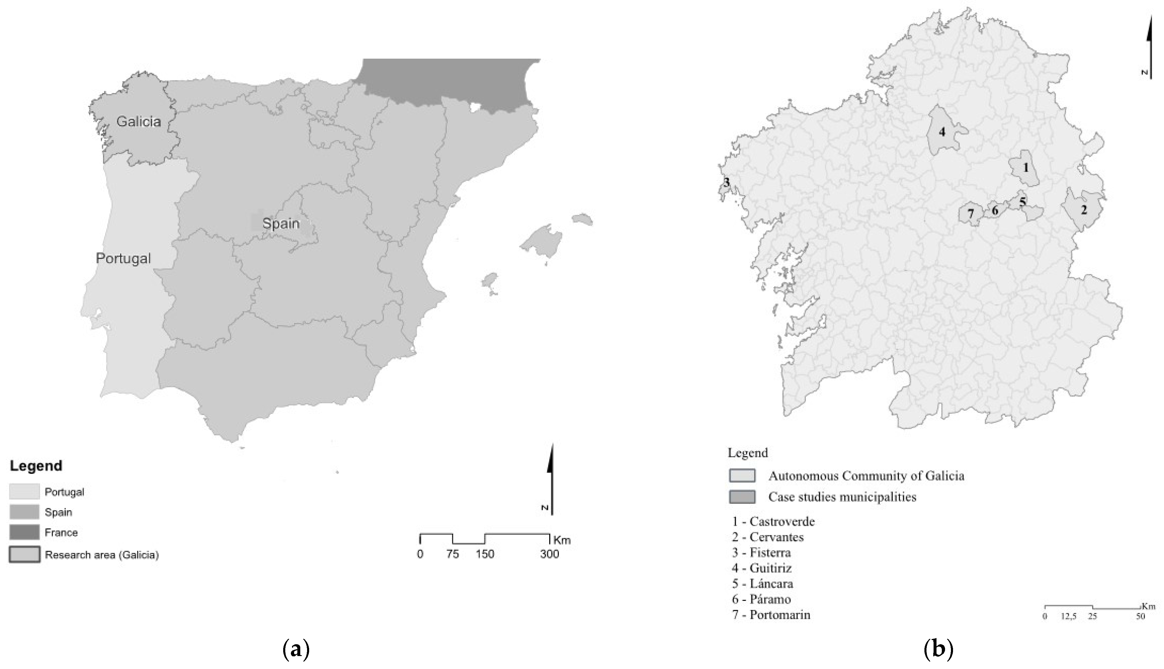
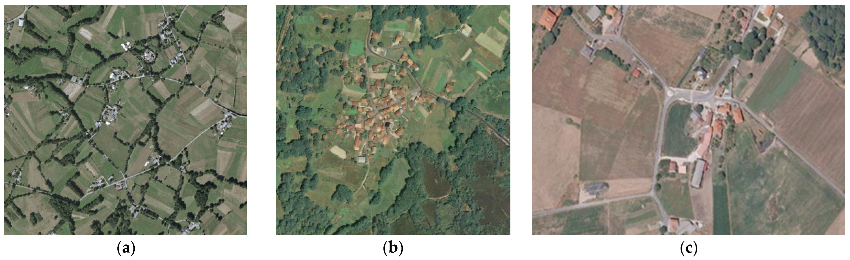
1.1. Territorial Context in Galicia
1.2. Rural Planning and Land Use Law Context in Galicia
2. Materials and Methods
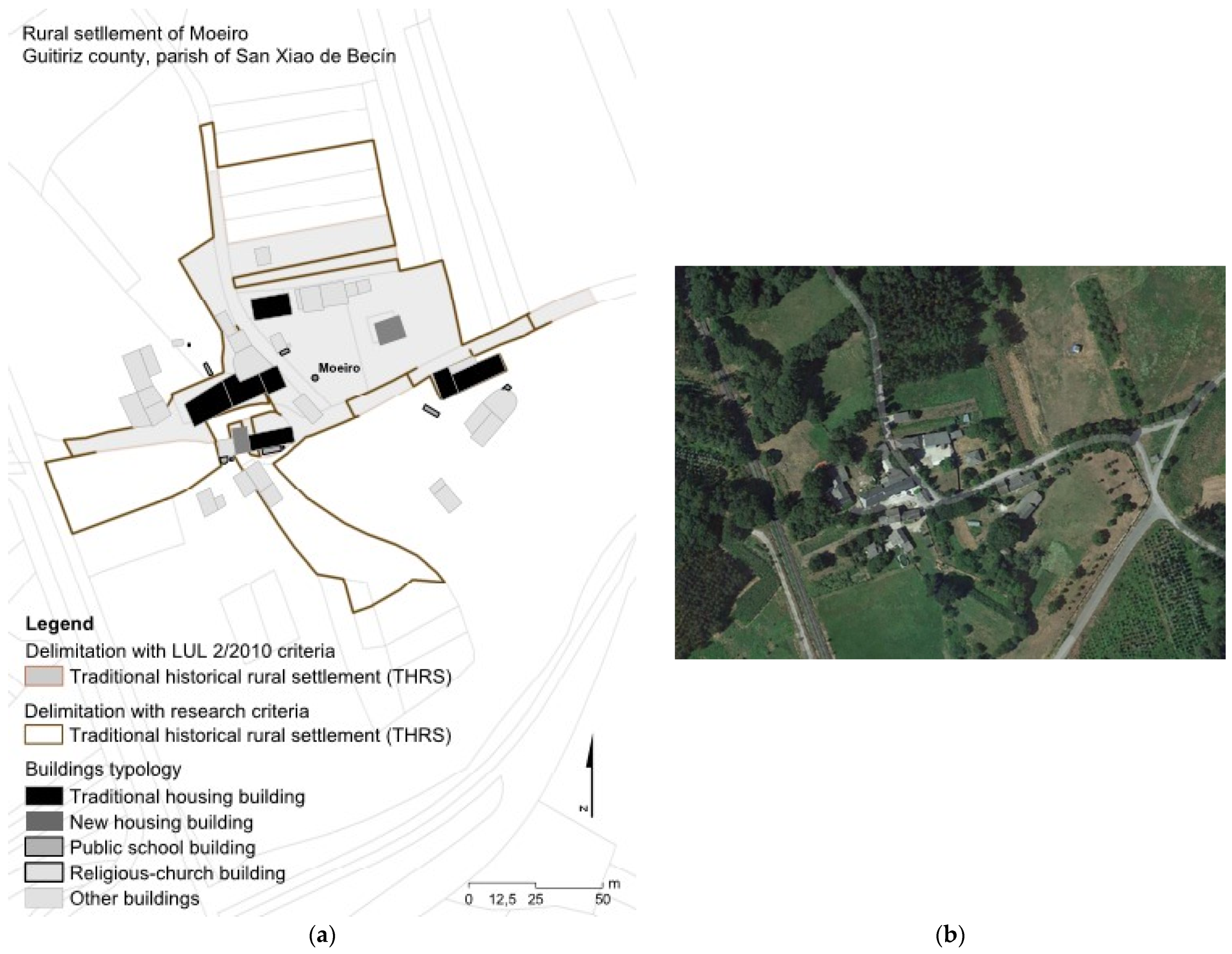
2.1. Criteria for the Identification and Delimitation of RS Set by LUL 2/2010
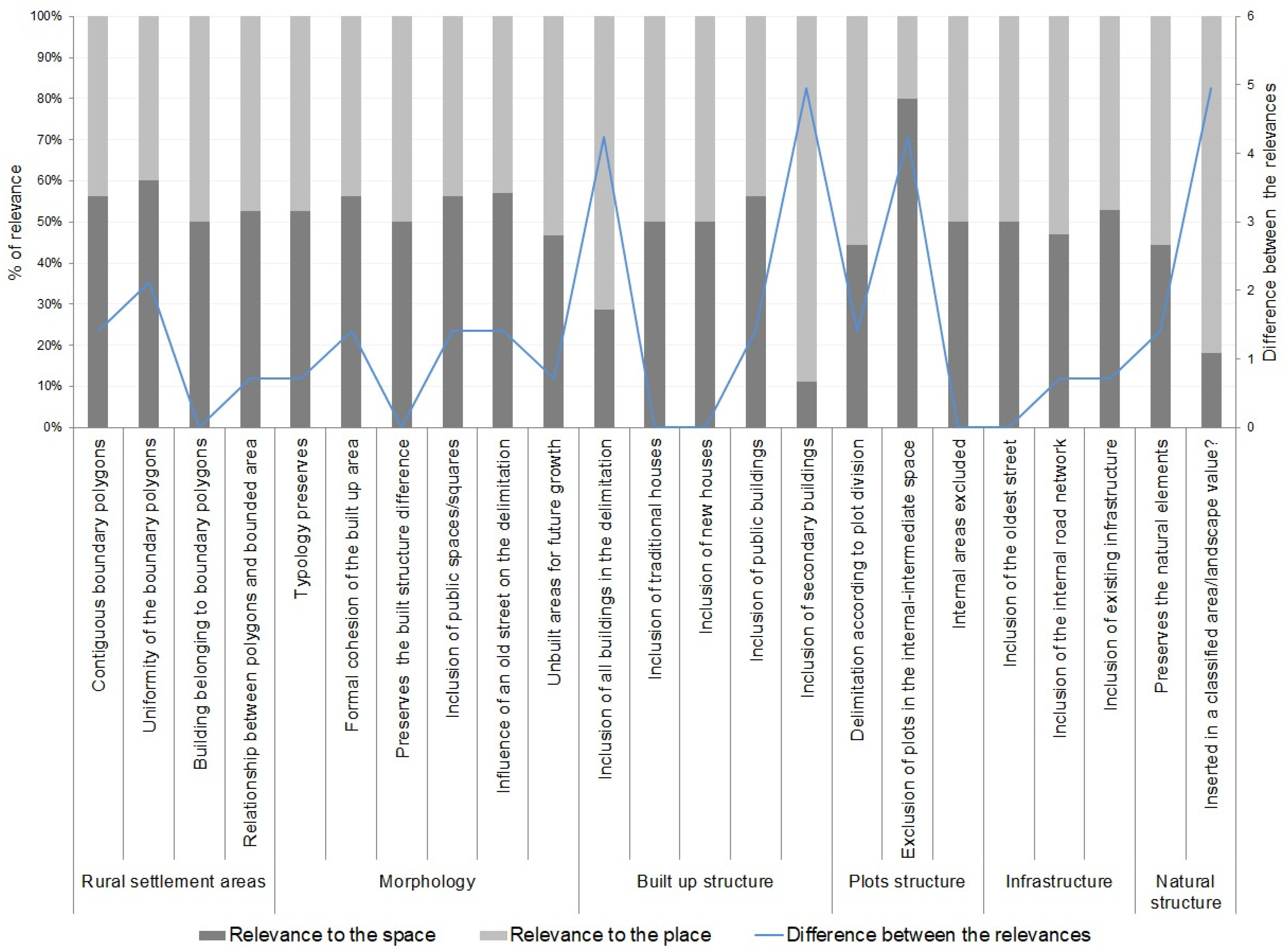
2.2. Criteria Proposed for the Identification and Delimitation of RS
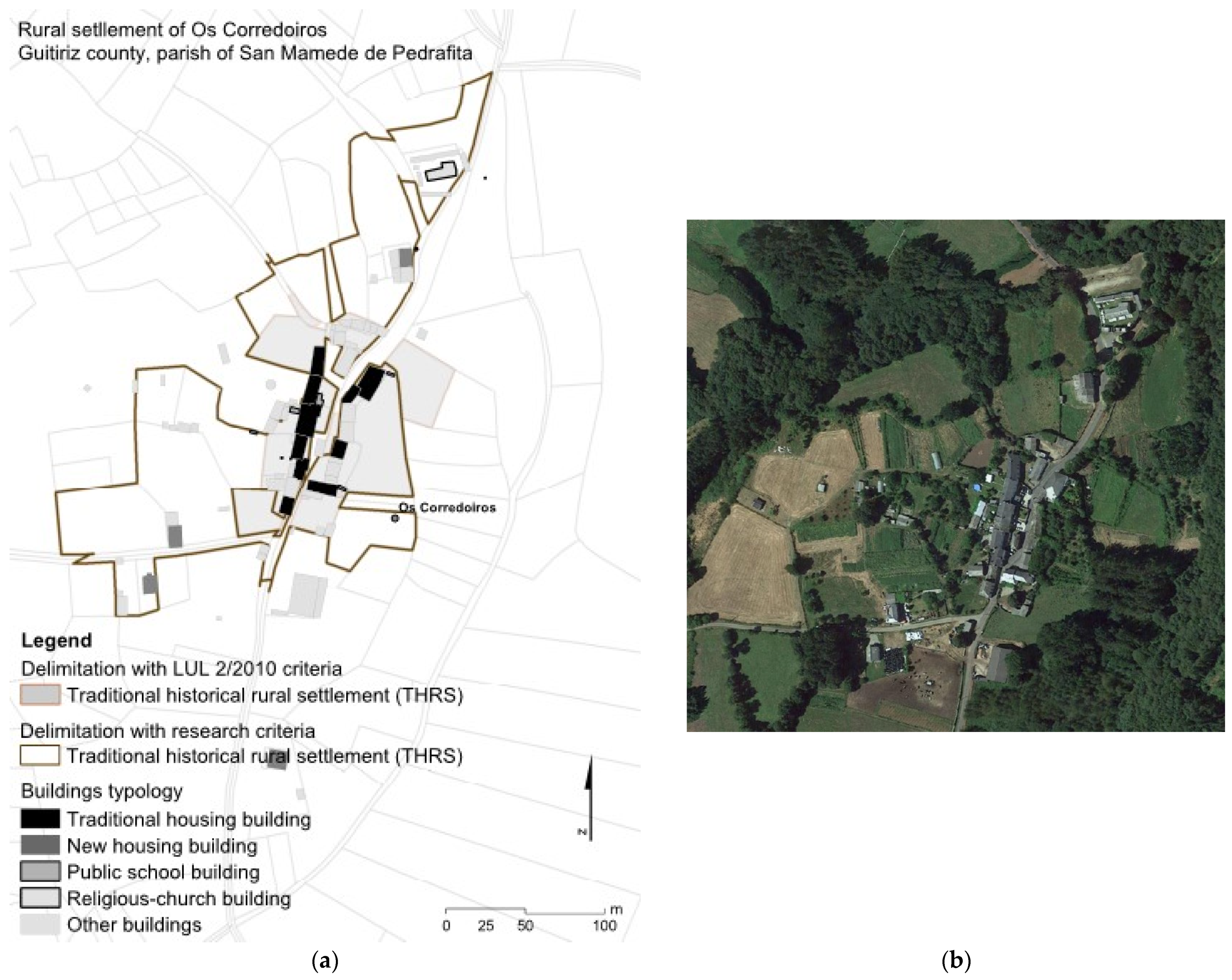
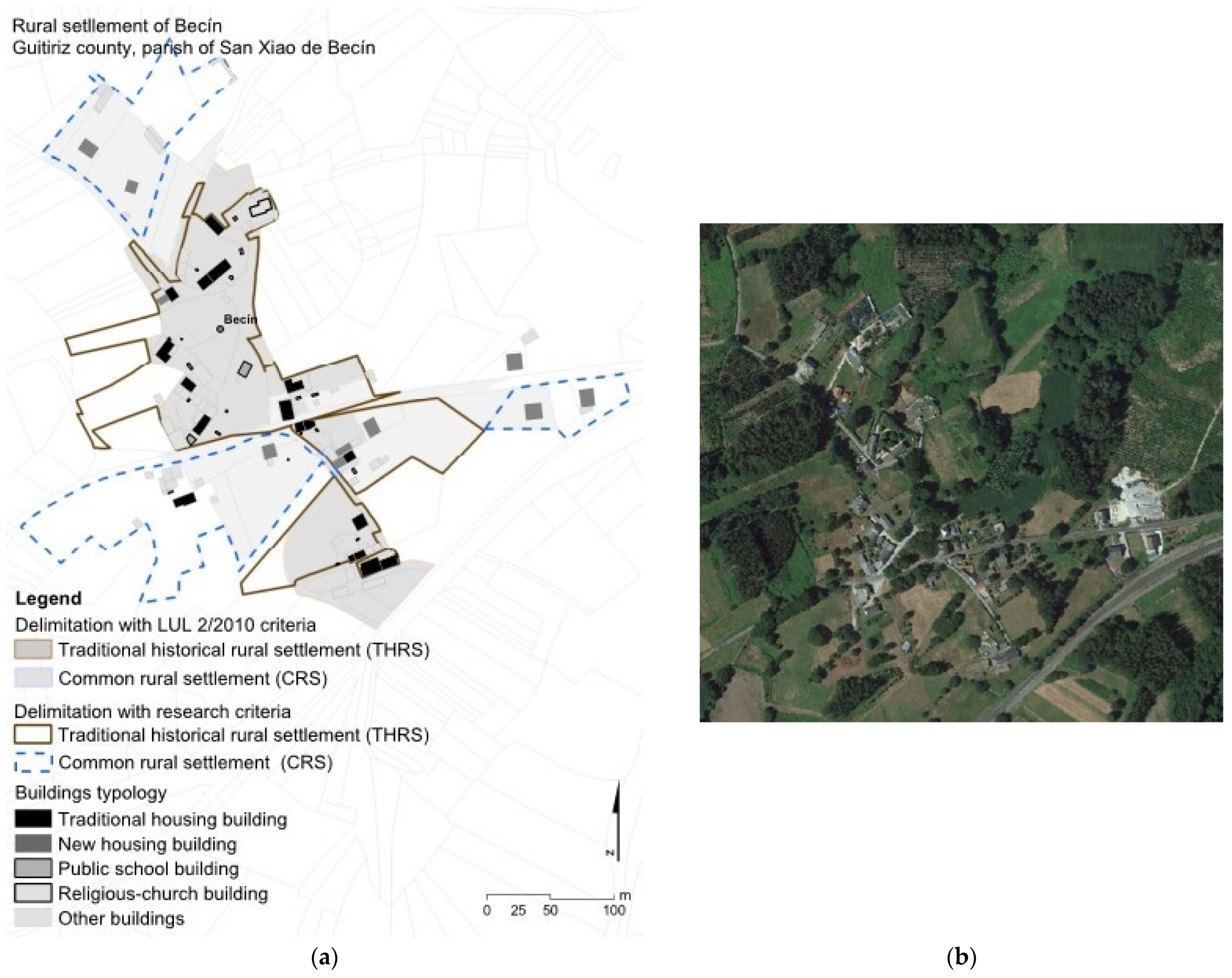
3. Results
4. Discussion
5. Conclusions
Author Contributions
Funding
Informed Consent Statement
Data Availability Statement
Acknowledgments
Conflicts of Interest
References
- Condesso, F. Rural development, cultural heritage and tourism. Cuad. Desarro. Rural 2011, 8, 197–222. [Google Scholar]
- Wang, Y. A Sustainable Approach for Post-Disaster Rehabitation of Rural Heritage Settlements. Sustain. Dev. 2016, 24, 319–329. [Google Scholar] [CrossRef]
- Pérez Martínez, M.E. La adaptabilidad de pobladores y asentamientos rurales en áreas de conurbación: El caso de la ciudad de Bogotá (Colombia). Cuad. Desarro. Rural 2011, 5, 25. [Google Scholar]
- Chen, F. Traditional architectural forms in market oriented Chinese cities: Place for localities or symbol of culture? Habitat Int. 2011, 35, 410–418. [Google Scholar] [CrossRef]
- Janečková, M.K.; Skřivanová, Z.; Kalivoda, O.; Sklenička, P. Rural identity and landscape aesthetics in exurbia: Some issues to resolve from a Central European perspective. Morav. Geogr. Rep. 2017, 25, 2–12. [Google Scholar] [CrossRef] [Green Version]
- Muilu, T.; Rusanen, J. Rural definitions and short-term dynamics in rural areas of Finland in 1989–97. Environ. Plan. A 2004, 36, 1499–1516. [Google Scholar] [CrossRef]
- Kong, X.; Liu, D.; Tian, Y.; Liu, Y. Multi-objective spatial reconstruction of rural settlements considering intervillage social connections. J. Rural Stud. 2021, 84, 254–264. [Google Scholar] [CrossRef]
- Tian, Y.; Kong, X.; Liu, Y.; Wang, H. Restructuring rural settlements based on an analysis of inter-village social connections: A case in Hubei Province, Central China. Habitat Int. 2016, 57, 121–131. [Google Scholar] [CrossRef]
- Li, Y.; Westlund, H.; Liu, Y. Why some rural areas decline while some others not: An overview of rural evolution in the world. J. Rural Stud. 2019, 68, 135–143. [Google Scholar] [CrossRef]
- Jia, K.; Qiao, W.; Chai, Y.; Feng, T.; Wang, Y.; Ge, D. Spatial distribution characteristics of rural settlements under diversified rural production functions: A case of Taizhou, China. Habitat Int. 2020, 102, 102201. [Google Scholar] [CrossRef]
- Mandal, R.B. Systems of Rural Settlements in Developing Countries; Concept Publishing Company: Delhi, India, 1989. [Google Scholar]
- Zonneveld, W.; Stead, D. European territorial cooperation and the concept of urban–rural relationships. Plan. Pract. Res. 2007, 22, 439–453. [Google Scholar] [CrossRef]
- Davoudi, S.; Stead, D. Urban-rural relationships: An introduction and brief history. Built Environ. 2002, 28, 269–277. [Google Scholar]
- Nilsson, K. Peri-Urban Land Use Relationships—PLUREL Project Strategies and Sustainability Assessment Tools for Urban-Rural Linkages; Publishable Final Activity Report; European Commission: Brussels, Belgium, 2011. [Google Scholar]
- Zasada, I.; Loibl, W.; Berges, R.; Steinnocher, K.; Köstl, M.; Piorr, A.; Werner, A. Rural–urban regions: A spatial approach to define urban–rural relationships in Europe. In Peri-Urban Futures: Scenarios and Models for Land Use Change in Europe; Springer: Berlin/Heidelberg, Germany, 2013; pp. 45–68. [Google Scholar]
- Serra, P.; Vera, A.; Tulla, A.F.; Salvati, L. Beyond urban-rural dichotomy: Exploring socioeconomic and land-use processes of change in Spain (1991–2011). Appl. Geogr. 2014, 55, 71–81. [Google Scholar] [CrossRef]
- Zhao, P.; Wan, J. Land use and travel burden of residents in urban fringe and rural areas: An evaluation of urban-rural integration initiatives in Beijing. Land Use Policy 2021, 103, 105309. [Google Scholar] [CrossRef]
- Pedroli, B.; Pinto Correia, T.; Primdahl, J. Challenges for a shared European countryside of uncertain future. Towards a modern community-based landscape perspective. Landsc. Res. 2016, 41, 450–460. [Google Scholar] [CrossRef] [Green Version]
- Primdahl, J.; Van Eetvelde, V.; Pinto-Correia, T. Rural landscapes—Challenges and solutions to landscape governance. Land 2020, 9, 521. [Google Scholar] [CrossRef]
- Bibby, P.; Shepherd, J. Developing a New Classification of Urban and Rural Areas for Policy Purposes—The Methodology; Defra: London, UK, 2004. [Google Scholar]
- Goncalves, J.; Castilho Gomes, M.; Ezequiel, S.; Moreira, F.; Loupa-Ramos, I. Differentiating peri-urban areas: A transdisciplinary approach towards a typology. Land Use Policy 2017, 63, 331–341. [Google Scholar] [CrossRef]
- Tang, C.; He, Y.; Zhou, G.; Zeng, S.; Xiao, L. Optimizing the spatial organization of rural settlements based on life quality. J. Geogr. Sci. 2018, 28, 685–704. [Google Scholar] [CrossRef] [Green Version]
- Mortoja, M.G.; Yigitcanlar, T.; Mayere, S. What is the most suitable methodological approach to demarcate peri-urban areas? A systematic review of the literature. Land Use Policy 2020, 95, 104601. [Google Scholar] [CrossRef]
- Cattivelli, V. Institutional Methods for the Identification of Urban and Rural Areas—A Review for Italy. In Green Energy and Technology; Springer Science and Business Media: Berlin/Heidelberg, Germany, 2021; pp. 187–207. [Google Scholar]
- Dickinson, R.E. Rural settlements in the German lands. Ann. Assoc. Am. Geogr. 1949, 39, 239–263. [Google Scholar] [CrossRef]
- Smailes, P.J.; Molyneux, J. The evolution of an Australian rural settlement pattern: Southern New England, NSW. Trans. Inst. Br. Geogr. 1965, 36, 31–54. [Google Scholar] [CrossRef]
- Jones, G.R.J. Some medieval rural settlements in North Wales. Trans. Inst. Br. Geogr. 1953, 19, 51–72. [Google Scholar] [CrossRef]
- Stone, K.H. The Development of a Focus for the Geography of Settlement. Econ. Geogr. 1965, 41, 346–355. [Google Scholar] [CrossRef]
- Mukerji, A. Rural settlements of the Chandigarh Siwalik Hills (India): A morphogenetic analysis. Geogr. Ann. B Phys. Geogr. 1976, 58, 95–115. [Google Scholar] [CrossRef]
- Donnelly, P.; Harper, S. British rural settlements in the hinterland of conurbations: A classification. Geogr. Ann. Ser. B Hum. Geogr. 1987, 69, 55–63. [Google Scholar] [CrossRef]
- Grossman, D.; Katz, Y. Rural Settlement Patterns in Eretz-Israel. Geogr. Ann. Ser. B Hum. Geogr. 1992, 74, 57–73. [Google Scholar] [CrossRef]
- Stoian, D.; Henkemans, A.B. Between extractivism and peasant agriculture: Differentiation of rural settlements in the Bolivian Amazon. Int. Tree Crops J. 2000, 10, 299–320. [Google Scholar] [CrossRef]
- Berbecar, V.T.; Cocheci, R.-M.; Acasandre, A.; Ismail, G.; Mircescu, G. Quality of living assessment in rural romania. An analysis of settlements with low accessibility to medical services. Int. J. Urban Reg. Res. 2020, 12, 165–180. [Google Scholar] [CrossRef]
- Chen, Z.; Li, Y.; Liu, Y. Distribution pattern characteristic and type classification of rural settlements in loess hilly-gully region. Trans. Chin. Soc. Agric. Eng. 2017, 33, 266–274. [Google Scholar]
- Lerise, F. Centralised spatial planning practice and land development realities in rural Tanzania. Habitat Int. 2000, 24, 185–200. [Google Scholar] [CrossRef]
- Vuksanovic, D.; Kalezic, J. Transposition of traditional patterns of built environment. In Proceedings of the Built Environments and Environmental Buildings, Eindhoven, The Netherlands, 19–21 September 2004; Wit, M.H.D., Ed.; Wageningen University: Wageningen, The Netherlands; Delft University of Technology: Delft, The Netherlands, 2004; pp. 19–22. [Google Scholar]
- Feng, W.; Wang, N.; Wang, C.; Li, G.; Zhang, C. Study on characteristics of rural settlements in the northeast loess plateau of china by RS&GIS. In Proceedings of the International Geoscience and Remote Sensing Symposium, IGARSS 2007, Barcelona, Spain, 23–28 July 2007; Volume 1, pp. 695–698. [Google Scholar] [CrossRef]
- Theodoraki, A.; Theodoraki-Patsi, J.; Theodoraki, P. Authenticity versus hybridity in rural Greece. Int. J. Sustain. Dev. Plan. 2007, 102, 261–272. [Google Scholar] [CrossRef]
- Günçe, K.; Ertürk, Z.; Ertürk, S. Questioning the “prototype dwellings” in the framework of Cyprus traditional architecture. Build. Environ. 2008, 43, 823–833. [Google Scholar] [CrossRef]
- Johansen, P.H.; Nielsen, N.C. Bridging between the regional degree and the community approaches to rurality—A suggestion for a definition of rurality for everyday use. Land Use Policy 2012, 29, 781–788. [Google Scholar] [CrossRef]
- Banski, J.; Wesolowska, M. Transformations in housing construction in rural areas of Poland’s Lublin region-Influence on the spatial settlement structure and landscape aesthetics. Landsc. Urban Plan. 2010, 94, 116–126. [Google Scholar] [CrossRef]
- Ma, W.; He, X.; Jiang, G.; Li, Y.; Zhang, R. Land use internal structure classification of rural settlements based on land use function. Trans. Chin. Soc. Agric. Eng. 2018, 34, 269–277. [Google Scholar]
- Healey, P. Relational complexity and the imaginative power of strategic spatial planning. Eur. Plan. Stud. 2006, 14, 525–546. [Google Scholar] [CrossRef]
- Fitchen, J.M.; Rosenzweig, S.G. Endangered Spaces, Enduring Places: Change, Identity, and Survival in Rural America; Routledge: London, UK, 2019. [Google Scholar]
- Zhou, G.; He, Y.; Tang, C.; Yu, T.; Xiao, G.; Zhong, T. Dynamic mechanism and present situation of rural settlement evolution in China. J. Geogr. Sci. 2013, 23, 513–524. [Google Scholar] [CrossRef]
- Li, G.; Jiang, C.; Du, J.; Jia, Y.; Bai, J. Spatial differentiation characteristics of internal ecological land structure in rural settlements and its response to natural and socio-economic conditions in the Central Plains, China. Sci. Total Environ. 2020, 709, 135932. [Google Scholar] [CrossRef]
- Benavent, E.; Soler, D. The directed rural postman problem with turn penalties. Transp. Sci. 1999, 33, 408–418. [Google Scholar] [CrossRef]
- Hadjimichalis, C. Imagining rurality in the new Europe and dilemmas for spatial policy. Eur. Plan. Stud. 2003, 11, 103–113. [Google Scholar] [CrossRef]
- Rosner, A.; Wesołowska, M. Deagrarianisation of the Economic Structure and the Evolution of Rural Settlement Patterns in Poland. Land 2020, 9, 523. [Google Scholar] [CrossRef]
- Abramovay, R. O Futuro das Regiões Rurais; Universidade Federal do Rio Grande do Sul: Porto Alegre, Brazil, 2009. [Google Scholar]
- Scott, M. Strategic spatial planning and contested ruralities: Insights from the Republic of Ireland. Eur. Plan. Stud. 2006, 14, 811–829. [Google Scholar] [CrossRef]
- Qu, Y.; Guanghui, J.; Qinglei, Z.; Wenqiu, M.; Ruijuan, Z.; Yuting, Y. Geographic identification, spatial differentiation, and formation mechanism of multifunction of rural settlements: A case study of 804 typical villages in Shandong Province, China. J. Clean. Prod. 2017, 166, 1202–1215. [Google Scholar] [CrossRef]
- Westhoek, H.J.; van den Berg, M.; Bakkes, J.A. Scenario development to explore the future of Europe’s rural areas. Agric. Ecosyst. Environ. 2006, 114, 7–20. [Google Scholar] [CrossRef]
- Courtney, P.; Talbot, H.; Skuras, D. The ESPON 2013 Programme Establishing the Potential for Territorial Cooperation; European Commission: Brussels, Belgium, 2010. [Google Scholar]
- Torreggiani, D.; Dall’Ara, E.; Tassinari, P. The urban nature of agriculture: Bidirectional trends between city and countryside. Cities 2012, 29, 412–416. [Google Scholar] [CrossRef]
- Hosseini, S.B.; Faizi, M.; Norouzian-Maleki, S.; Azari, A.R.K. Impact evaluation of rural development plans for renovating and retrofitting of rural settlements. Environ. Earth Sci. 2015, 73, 3033–3042. [Google Scholar] [CrossRef]
- Lacour, C.; Puissant, S. Re-urbanity: Urbanising the rural and ruralising the urban. Environ. Plan A 2007, 39, 728–747. [Google Scholar] [CrossRef]
- Jianchao, X.; Xinge, W.; Qinqin, K.; Nan, Z. Spatial morphology evolution of rural settlements induced by tourism. J. Geogr. Sci. 2015, 25, 497–511. [Google Scholar]
- Precedo Ledo, A.J.; Míguez Iglesias, A.; Fernández Justo, M.I. Galicia: El tránsito hacia una sociedad urbana en el contexto de la unión europea. Rev. Galega Econ. 2008, 17, 89–108. [Google Scholar]
- INE. Estadísticas del Padrón Continuo. En. 2019. Available online: https://ine.es/dynt3/inebase/es/index.htm?type=pcaxis&file=pcaxis&path=%2Ft20%2Fe245%2Fp05%2F%2Fa2000 (accessed on 15 December 2019).
- Bouhier, A. Galicia: Ensaio Xeográfico de Análise e Interpretación dun vello Complexo Agrario; Biblioteca de Clásicos Agrarios Galegos, vol. XVI (translated from 1979); Consellería de Agricultura, Gandería e Política Agroalimentaria: Xunta de Galicia, Spain, 2001.
- Lautensach, H. Geografía de España y Portugal; Vicens-Vives: Barcelona, Spain, 1967. [Google Scholar]
- Tojo, F.J. Los Assentamientos Rurales en Galicia; Escuela Técnica Superior de Arquitectura de Madrid: Madrid, Spain, 1980. [Google Scholar]
- Dax, T.; Kahila, P.; Hörnström, L. The evolution of EU Rural Policy: Linkages of Cohesion Policy and Rural Development policy. In Proceedings of the Annual International Conference, Newcastle, UK, 30 April 2011; Volume I, p. 18. [Google Scholar]
- Gorb, O.; Yasnolob, I.; Alla, D.; Kaliuzhna, Y. The formation of the management system of ecological, social, and economic development of rural territories using the experience in European Union. J. Environ. Manag. Tour. 2017, 8, 516–528. [Google Scholar] [CrossRef]
- Van Berkel, D.B.; Carvalho-Ribeiro, S.; Verburg, P.H.; Lovett, A. Identifying assets and constraints for rural development with qualitative scenarios: A case study of Castro Laboreiro, Portugal. Landsc. Urban Plan. 2011, 102, 127–141. [Google Scholar] [CrossRef]
- Mao, Y.; Liu, Y.; Wang, H.; Tang, W.; Kong, X. A spatial-territorial reorganization model of rural settlements based on graph theory and genetic optimization. Sustainability 2017, 9, 1370. [Google Scholar] [CrossRef] [Green Version]
- Goodale, M.R.G.; Sky, P.K. A comparative study of land tenure, property boundaries, and dispute resolution: Case studies from Bolivia and Norway. J. Rural Stud. 2001, 17, 183–200. [Google Scholar] [CrossRef]
- Xiaoliang, H.; Hongbo, L.; Xiaolin, Z.; Yuan, Y.U.A.N. On the re-cognition of rural definitions. Acta Geol. Sin. 2020, 75, 02000398. [Google Scholar]
- Reid, J.A.; Green, B.; Cooper, M.; Hastings, W.; Lock, G.; White, S. Regenerating rural social space? Teacher education for rural—Regional sustainability. Aust. J. Educ. 2010, 54, 262–276. [Google Scholar] [CrossRef] [Green Version]
- Waage, S.; Mulder, I.; ten Kate, K.; Scherr, S.; Roberts, J.P.; Hawn, A.; Hamilton, K.; Bayon, R.; Carroll, N. Investing in the future: An assessment of private sector demand for engaging in markets & payments for ecosystem services. PESAL Pap. Ser. 2007, 2. [Google Scholar]
- Halfacree, K. Rural space: Constructing a three-fold architecture. In Handbook of Rural Studies; Sage: London, UK, 2006; pp. 44–62. [Google Scholar]
- Halfacree, K.H. Locality and social representation: Space, discourse and alternative definitions of the rural. J. Rural Stud. 1993, 9, 23–37. [Google Scholar] [CrossRef]
- Wineman, A.; Alia, D.Y.; Anderson, C.L. Definitions of “rural” and “urban” and understandings of economic transformation: Evidence from Tanzania. J. Rural Stud. 2020, 79, 254–268. [Google Scholar] [CrossRef]
- Olson, J.L.; Munroe, D.K. Natural amenities and rural development in new urban-rural spaces. Reg. Sci. Policy Pract. 2012, 4, 355–371. [Google Scholar] [CrossRef]
- Forleo, M.B.; Giaccio, V.; Giannelli, A.; Mastronardi, L.; Palmieri, N. Socio-economic drivers, land cover changes and the dynamics of rural settlements: Mt. Matese Area (Italy). Eur. Countrys 2017, 9, 435. [Google Scholar] [CrossRef] [Green Version]
- Haining, R. Describing and modeling rural settlement maps. Ann. Assoc. Am. Geogr. 1982, 72, 211–223. [Google Scholar] [CrossRef]
- Graham, S.; Healey, P. Relational concepts of space and place: Issues for planning theory and practice. Eur. Plan. Stud. 1999, 7, 623–646. [Google Scholar] [CrossRef]
- Mahon, M. New populations; shifting expectations: The changing experience of Irish rural space and place. J. Rural Stud. 2007, 23, 345–356. [Google Scholar] [CrossRef]
- Belanche, D.; Casaló, L.V.; Rubio, M.A. Local place identity: A comparison between residents of rural and urban communities. J. Rural. Stud. 2021, 82, 242–252. [Google Scholar] [CrossRef]
- Healey, P. The treatment of space and place in the new strategic spatial planning in Europe. Int. J. Urban. Reg. Res. 2004, 28, 45–67. [Google Scholar] [CrossRef]
- Ren, Y.; Xu, Q.; Long, H. Spatial distribution characteristics and optimized reconstruction analysis of China’s rural settlements during the process of rapid urbanization. J. Rural Stud. 2016, 47, 413–424. [Google Scholar]
- Benedetto, A. Nuevas alternativas para pensar el desarrollo de los territorios rurales. Posibilidades y riesgos. Cuad. Desarro. Rural 2006, 57, 101–131. [Google Scholar]
- Trukhachev, A. Methodology for evaluating the rural tourism potentials: A tool to ensure sustainable development of rural settlements. Sustainability 2015, 7, 3052–3070. [Google Scholar] [CrossRef] [Green Version]
- Geddes, I. Understanding the Mechanisms and Impact of Growth on the Urban Form and Functioning of Cities: An Application to the Case of Limassol. Athens J. Mediterr. Stud. 2020, 6, 39–66. [Google Scholar] [CrossRef]
- Porta, J.; Parapar, J.; Doallo, R.; Barbosa, V.; Santé, I.; Crecente, R.; Díaz, C. A population-based iterated greedy algorithm for the delimitation and zoning of rural settlements. Comput. Environ. Urban Syst. 2013, 39, 12–26. [Google Scholar] [CrossRef]
- Barbosa-Brandão, V.; Santé Riveira, I.; Crecente Maseda, R. Evolution of legal criteria for the identification and zoning of rural settlements in Galicia, NW Spain. Eur. Plan. Stud. 2015, 23, 398–429. [Google Scholar] [CrossRef]

| Essentialist Conception of the RS | Relational Conception of RS | |
|---|---|---|
| RS Space | RS Place | |
| Scale treatment | Adaptation to the scale among RSs | To establish interaction of the RS |
| Materiality and identity | Physical dimension of RS as a spatial meaning | To interpret distribution of the built set as social significance |
| Development concept | Even spatial evolution of RS | The quality of a place must produce several shapes in a RS |
| Representation form | Multiple RSs with no integration relationships among them | Morphological diversity expresses several social relationships |
| Approach | Physical Features | Social Features | Spatial Relations | Human–Physical Relations |
|---|---|---|---|---|
| Historical–geographical |
|
|
|
|
| Process typological |
|
|
|
|
| Configurational |
|
|
|
|
| Spatial analytical |
|
|
|
|
| Spatial Characteristic | Restriction/Condition | Identification and Delimitation of RS | Rural Settlement |
|---|---|---|---|
| Preserving typology | Condition for THRS and CRS | Identification | To differentiate between main built set and surrounding building |
| Inclusion of traditional houses | Restriction for THRS | Identification | Minimum number of traditional houses in a polygon |
| Inclusion of new houses | Restriction for CRS | Identification | Minimum number of houses in a polygon |
| Buildings belonging to delimitation polygons | Restriction for THRS and CRS | Delimitation | Minimum number of buildings and the distance from each other in a polygon |
| Inclusion of the oldest street | Condition for THRS and CRS | Delimitation | Difference between plots in direct or indirect contact |
| Inclusion of the internal road network | Condition for THRS and CRS | Delimitation | Difference between plots in direct or indirect contact |
| Inclusion of internal infra-structures | Condition for THRS and CRS | Delimitation | Difference between plots according to the distance |
| Relationship between polygons and delimited area | Restriction for THRS and CRS | Delimitation | Minimum consolidation % per polygon |
| To preserve the difference of the built facility | Condition for THRS and CRS | Delimitation | Difference between the 1st polygon and the remaining ones according to the buildings by typology (traditional or new) and use (residential or others) |
| Empty areas for further growth | Restriction for THRS and CRS | Delimitation | Maximum surface according to % among traditional houses over new houses |
| Excluded inner areas | Restriction for THRS and CRS | Delimitation | No polygon may have empty areas |
| Criterion Number | Spatial Dimension | Criterion Identification | Criterion Description–Tradition Historical Rural Settlement Area (THRSA) |
|---|---|---|---|
| 01 | Identification | Minimum area of the main buildings. | A minimum of three (3) traditional housing buildings (THbu) should exist—that is, “traditional house” in one polygon at least to form a RS area. |
| 02 | Minimum area of the surrounding buildings. | The following polygons (no. 2) for their minimal conditions of existence should have two traditional houses at least to form a RS area. | |
| 03 | Delimitation | Average characteristic distance. | With a minimum of three (3) traditional houses—that is, residential character buildings, the average characteristic distance (ACD) of the RS is calculated from the THbu centroids (traditional or others to be selected) by the average (25%, 50% or 75%) of the number of THbu (traditional or others to be selected) with the shortest distance among them. |
| 04 | Main building for the first polygon. | A first buffer is designed in all THbu (traditional or selected) where 1.5 ∗ ACD of the RS is considered and those intersecting, directly belonging to the THRS area as the main building set, defining the 1st delimiting. | |
| 05 | Surrounding building for the second polygon. | The calculation 0.5 ∗ ACD is carried out around the previous polygons of THRS (with more than two THbu, traditional or newer other selected), and those not intersected in the 1st buffer but in the 2nd buffer will belong to the 1st proximity as surrounding building. The new polygons should have two (2) THbu. | |
| Criterion number | Spatial Dimension | Criterion identification | Criterion description–Common rural settlement area (CRSA) |
| 06 | Identification | Minimum area of the main buildings. | At least two (2) housing buildings (traditional or new THbu) should exist in the first polygon, (when there is no THRS area), whose distance is 2 ∗ DMC to form RS area. |
| 07 | Minimum area of the surrounding buildings. | The following polygons (number 2) must have at least two residential buildings (Rbu) (traditional or new) for their minimal existing condition to form RS area. | |
| 08 | Delimitation | Main building set | A buffer 2 ∗ DMC of RS is designed in all Rbu (or others to be selected) and those that are intersected now belong to the main commonly built set. |
| Criterion number | Spatial dimension | Criterion identification | Criterion description—Maximum surface of rural settlement |
| 09 | Delimitation | New residential buildings. | Whether the number of new residential buildings (NRbu) is greater than 50% of Rbu, the objective is to allow the building of NRbu all over the RS as maximum, equal to the number of existing Rbu. Whether the number of NRbu is between 25% and 50%, the objective is to allow the building of NRbu all over the RS as a maximum, equal to the number of existing NRbu for CRS or half (50%) of existing NRbu in THRS. According to the condition of existing THRS and CRS, the number of NRbu will be half (50%) of the existing NRbu for each area. Whether the number of NRbu is fewer than 25%, the objective is to allow the building of NRbu: in CRS as a maximum of the half (50%) of existing NRbu all over the settlement and in THRS as a maximum of 25% of NRbu existing all over the settlement. Whether the settlement has only THRS, it can be built only up to the maximum of the half (50%) of the existing Rbu. |
| Criterion number | Spatial dimension | Criterion identification | Criterion description—Rural settlement consolidation |
| 10 | Delimitation | Polygon consolidation | The degree of consolidation of a settlement is defined by the relationship between the existing plots (those that have an established building according to the occupied area) and the sum of new plots of type I and II. Type I plots are those with no consolidated building presenting a surface equal to or greater than the minimum buildable surface (MBS) with the first neighboring track. Type II plots are those with no consolidated building with a surface smaller than the MBS and with the first neighbor to the road. Such plots are united if the union surface is greater than the MBS; then, they are also inserted into the consolidation. |
Publisher’s Note: MDPI stays neutral with regard to jurisdictional claims in published maps and institutional affiliations. |
© 2022 by the authors. Licensee MDPI, Basel, Switzerland. This article is an open access article distributed under the terms and conditions of the Creative Commons Attribution (CC BY) license (https://creativecommons.org/licenses/by/4.0/).
Share and Cite
Barbosa, V.; Santé-Riveira, I.; Crecente-Maseda, R.; Redondo, C.D.; Trinidad, J.P.; López, J.P.; Biempica, R.D.; Ferreira Neto, J.A. A New Spatial Criteria Method to Delimit Rural Settlements towards Boundaries Equity: Land Use Optimization for Decision Making in Galicia, NW Spain. Land 2022, 11, 800. https://doi.org/10.3390/land11060800
Barbosa V, Santé-Riveira I, Crecente-Maseda R, Redondo CD, Trinidad JP, López JP, Biempica RD, Ferreira Neto JA. A New Spatial Criteria Method to Delimit Rural Settlements towards Boundaries Equity: Land Use Optimization for Decision Making in Galicia, NW Spain. Land. 2022; 11(6):800. https://doi.org/10.3390/land11060800
Chicago/Turabian StyleBarbosa, Vasco, Inés Santé-Riveira, Rafael Crecente-Maseda, Carlos Díaz Redondo, Juan Porta Trinidad, Jorge Parapar López, Ramón Doallo Biempica, and José Ambrósio Ferreira Neto. 2022. "A New Spatial Criteria Method to Delimit Rural Settlements towards Boundaries Equity: Land Use Optimization for Decision Making in Galicia, NW Spain" Land 11, no. 6: 800. https://doi.org/10.3390/land11060800
APA StyleBarbosa, V., Santé-Riveira, I., Crecente-Maseda, R., Redondo, C. D., Trinidad, J. P., López, J. P., Biempica, R. D., & Ferreira Neto, J. A. (2022). A New Spatial Criteria Method to Delimit Rural Settlements towards Boundaries Equity: Land Use Optimization for Decision Making in Galicia, NW Spain. Land, 11(6), 800. https://doi.org/10.3390/land11060800