1. Introduction
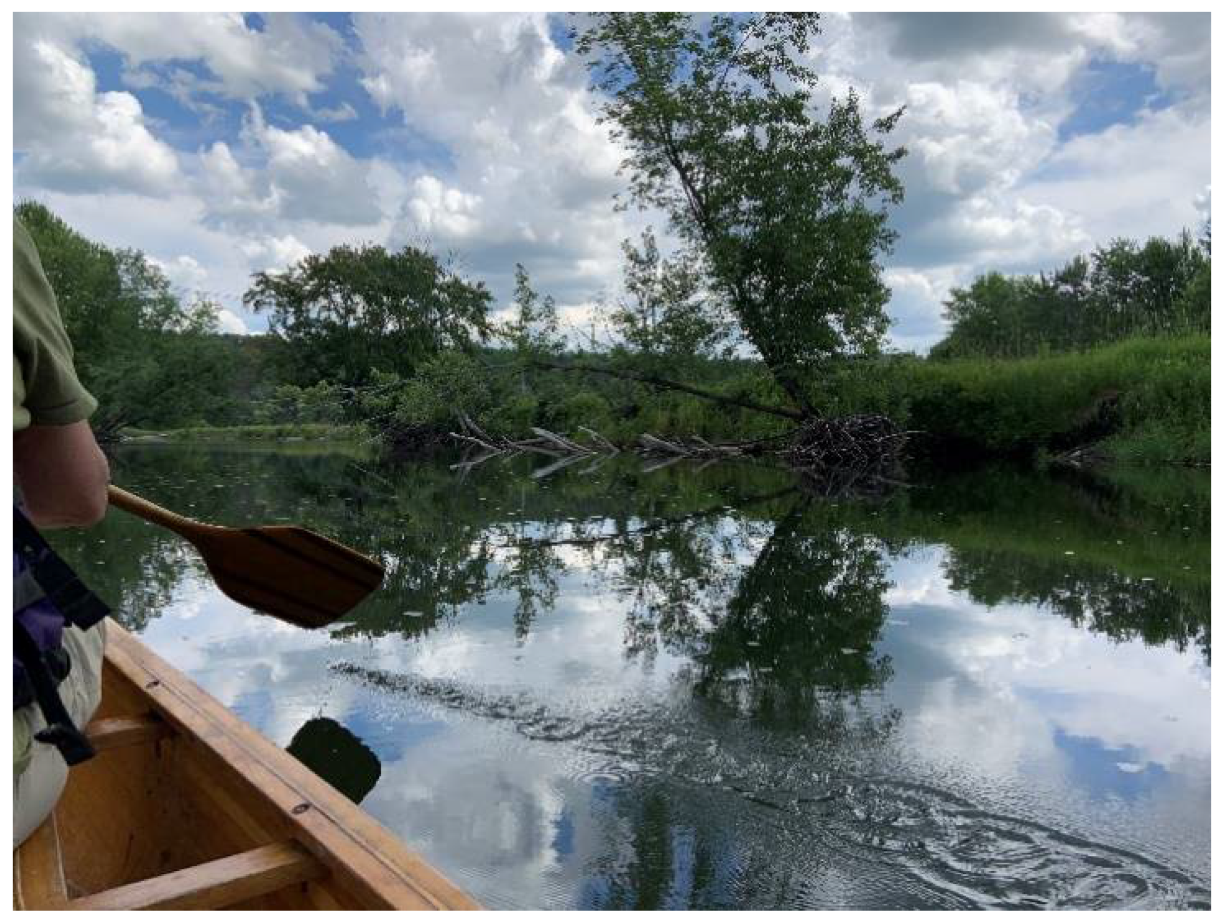
The afternoon sunlight illuminated the towering canopies of the maples, birches, and poplars; they gracefully shaded the Missisquoi River—and my neck—as our canoe floated downstream. Our canoe approached coarse woody debris from a downed tree, and the ‘captain’ of our boat, Martin, artfully maneuvered under the hanging branches. Martin is the president of the Missisquoi River Basin Association (MRBA), a volunteer-based, non-profit that strives “to restore and maintain the ecological integrity of the Missisquoi River system” while bringing together diverse interest groups [
1]. He explained how the fallen trees, besides being a nuisance to paddlers, also provide essential habitat for fish. I was fascinated by the river’s niche ecosystems, entranced by its beauty, and grateful for this refreshing recreational activity. The river offered a way to grow closer to the local landscape, to discover wildlife, and to appreciate the intricacies and power of nature. (From Author 1’s Research Fieldnotes).
These fieldnotes were taken during the course of a research project on the Missisquoi River in rural, northern Vermont (VT). The study had two purposes: (1) to better understand the place-based and river-focused perspectives of landowners along the Upper Missisquoi River and its tributaries, and (2) to test the effectiveness of photovisualizations (PVZs) as a qualitative research method in the context of Vermont’s shift from active to passive river management strategies. The paddle with Martin offered an opportunity to see the study area—riverside landscapes in the towns of Lowell, Westfield, and Troy, Vermont—from the perspective of the Missisquoi itself. By interacting directly with the waterway, Author 1 began to form a relationship with the riverine landscape, which emerged as a complex palimpsest, made of countless entwined layers of unique wildlife habitats, human activities and developments, and evolving river management practices [
2]. The riverine “landscape” included not only the physical layers of the varying ecosystem processes, but also the intangible dimension of temporality. Author 1’s experience on that summer day was just one snapshot of the river’s many forms, functions, and seasons (
Figure 1).
Interviews with residents, using both traditional interview methods and PVZs, revealed that sense of place becomes enriched and complex over time. We found that PVZs can serve as both a qualitative research method and communication tool for river conservation efforts. Our results show the importance of considering multiple physical viewpoints when pursuing land-based solutions to river management issues.
1.1. Performance, Sense of Place, and Temporality in Riverscapes
Landscapes, such as the Missisquoi River and its adjacent land, are holistic systems that connect biophysical characteristics to emotions, values, and identities [
3]. As people engage with the land through various senses and actions, a process known as “performance”, they build their identities and a perception of the landscape [
4,
5,
6]. In a rural setting, performances may consist of recreational activities such as biking, walking, or paddling; they also include work-based activities, such as cropping or cleaning up debris from a flood, and these activities can generate a strong attachment to place [
4,
6].
Ingold (1993) asserts that performance is not an act upon a landscape, but rather a movement with the landscape through time, leading to a constantly evolving sense of place [
7]. Temporality, or the flow of time, is intrinsic to a landscape; a landscape never reaches a final form, but rather it continuously transforms itself and the humans moving with it [
7]. The term performance can be used inversely as well: a landscape can “perform” on a viewer or participant through its esthetics, resulting in a poly-sensual experience and cultural impact that transforms the mind [
5]. Ingold’s (2011) term “meshwork” emphasizes the entwined and accumulative nature of people’s actions on a landscape, leading to “dense knots” or strong place meanings [
8] (p. 194).
Kibler and colleagues define sense of place, or attachment to place, as “the meaning an individual or group ascribes to a geographic location”, with considerations of the physical location, the activities taking place there, and the meanings associated with human experiences in the landscape [
9]. Impactful and successful restoration projects must meet the needs and preferences of stakeholders and work well with the ecosystem’s dynamics [
9]. Sense of place provides a useful framework to incorporate the social dimensions of landscapes within ecosystem restoration [
9]. Following from this, our research aimed to understand how the embodied human experience of a river place impacts the trajectories of environmental initiatives.
1.2. Viewing Place and Landscapes through Particular Lenses
People interpret human activity and the value of land through particular lenses. English farmers, for example, judge neighbors’ activities based on the appearance of a crop field or the condition of livestock [
10]. In rural Washington State, newcomers view particular land practices as sound stewardship while longtime residents may code the same practices as neglectful [
11]. Additionally, in Vermont, policymakers exclude some activities which some rural residents deem essential, such as gravel mining and the construction of new homes, in their definitions of working landscapes [
12]. It is necessary to understand what residents “see” when they view their watershed and what they consider to be good and acceptable practices in order to advance river conservation efforts on private property.
Mould (2019) explored how viewers perceived dammed landscapes using historic images and 3D imagery. He created an exhibit of these images with the goal of using “double vision”—science and art—to help viewers make sense of landscape changes and their own sense of place. Mould (2019) found that visual images served as a bridge between science and art and between the ideas of the presenter and viewer. The use of still visuals (as opposed to Google Earth) focuses the viewer’s attention on specific landscape changes, creating a common boundary and talking point for both parties [
3]. His work suggests that visual images can serve as both a research method and a tool to capture emotional and personal responses to landscape change [
13].
1.3. Photovisualizations (PVZs) as a Research Method and Communication Tool
Effective communication of information is key to increasing the understandability and acceptability of landscape changes. Visual learning tools have been shown to increase engagement, learning, emotional response, and even behavioral change [
14,
15]. PVZs create a common ground for stakeholder dialogue; they stimulate consideration of project details and questions that people may not ask otherwise [
16]. At the local level, PVZs can guide discourse and gauge reactions with regard to changes to familiar, well-known landscapes [
17].
PVZs have been used to uncover multistakeholder perceptions of agricultural landscapes and local adaptations to climate change [
15,
18,
19]. Wilhelm et al. (2020) observed that PVZs can reveal similarities and differences in landscape perspectives among groups (in this case, food system stakeholders and the general public). These preferences, in turn, can inform landscape uses and changes, such as agricultural expansion onto non-agricultural land [
19].
Schattman, Hurley, and Caswell (2019) and Schattman et al. (2020) presented four PVZs of climate adaptation practices to agricultural stakeholders in focus groups [
15] and surveys at six agricultural conferences in Vermont [
18]. These studies demonstrated advantages of PVZs: their ability to generate discussions and questions surrounding the costs and benefits of the proposed practices; to aid in understanding unfamiliar practices; and to generate dialogue and questions particularly for high-cost and high-risk practices [
15,
18].
The above and other studies found PVZs to be most effective when paired with other communication forms and outreach, such as in-person visits and workshops [
15,
18,
20,
21]. Participants suggested the use of short videos, worst-case scenario images, and depictions of visual changes of practices over time to enhance the effectiveness of the PVZs [
15].
Limitations of PVZs include the amount of preparatory work involved in their creation, the boundaries and biases of a static visual presentation, and their potential for misuse or manipulation [
16,
22]. Pettit et al. (2011) emphasize the need to further evaluate the strengths and weaknesses of landscape visualizations in communicating landscape scenarios to end users. Their “end users”, however, are the planners who may use the visualizations; the researchers do not discuss laypersons’ responses to the use of the visuals [
23]. The true end users in any landscape scenario are the people who live and work on the land in question. Our research contributes to the call for the evaluation of the pros and cons of using PVZs while expanding the definition of the end user to include individual landowners.
1.4. Landowner Willingness to Engage in Conservation Efforts
Landowners’ attitudes and perceptions towards conservation interventions on local land are strongly influenced by pre-existing place meanings [
4]. Many studies consider the factors that either encourage or discourage landowners to participate in conservation initiatives (e.g., [
4,
24,
25]). Arbuckle (2013) explored which factors influence a farmer’s attitudes towards agricultural conservation programs in Iowa, employing geospatial technology to evaluate variability across natural and agricultural systems. Similarly, in Vermont, river scientists at the Department of Environmental Conservation (DEC) have used geospatial data to contact landowners of prioritized lands and to decide which applications to fund for establishing river corridor easements [
26,
27]. Arbuckle (2013) showed that the targeted approach to conservation is broadly accepted by farmers in Iowa, suggesting that farmers are ready for shifts in conservation strategies. In Costa Rica, Powlen and Jones (2019) demonstrated that educational and material support from conservation organizations largely influences landowner participation in reforestation efforts. Financial incentives did not guarantee practice adoption; rather, adequate knowledge and training and provided trees and fencing material were preferred forms of support [
25].
Farmers and landowners are increasingly asked to help inform research and policy drawing on their constant interactions and consequential familiarity with their own land [
28]. Engagement with stakeholders allows for the inclusivity of those who will be directly affected by any changes; the acceptability of new proposals through the increase in communication, trust, and legitimacy; and the effectiveness of products by better understanding how to transfer science to practice [
28]. Understanding how landowners perceive and relate to the land will help increase the chances of impactful and long-lasting conservation efforts.
1.5. Study Context: The Missisquoi River and Water Quality Initiatives in Vermont
This research, which centers on how people view and interpret a riverscape, took place within a broader cultural context of a strongly developed sense of place. Several studies have documented Vermonters’ attachment to place, specifically to the physical landscape itself [
6,
29,
30]. Vermonters also tend to express appreciation for “working landscapes”, which are the outcome of productive and extractive engagements with land, including farming, logging, recreational activities, and landscape-based tourism [
12,
31].
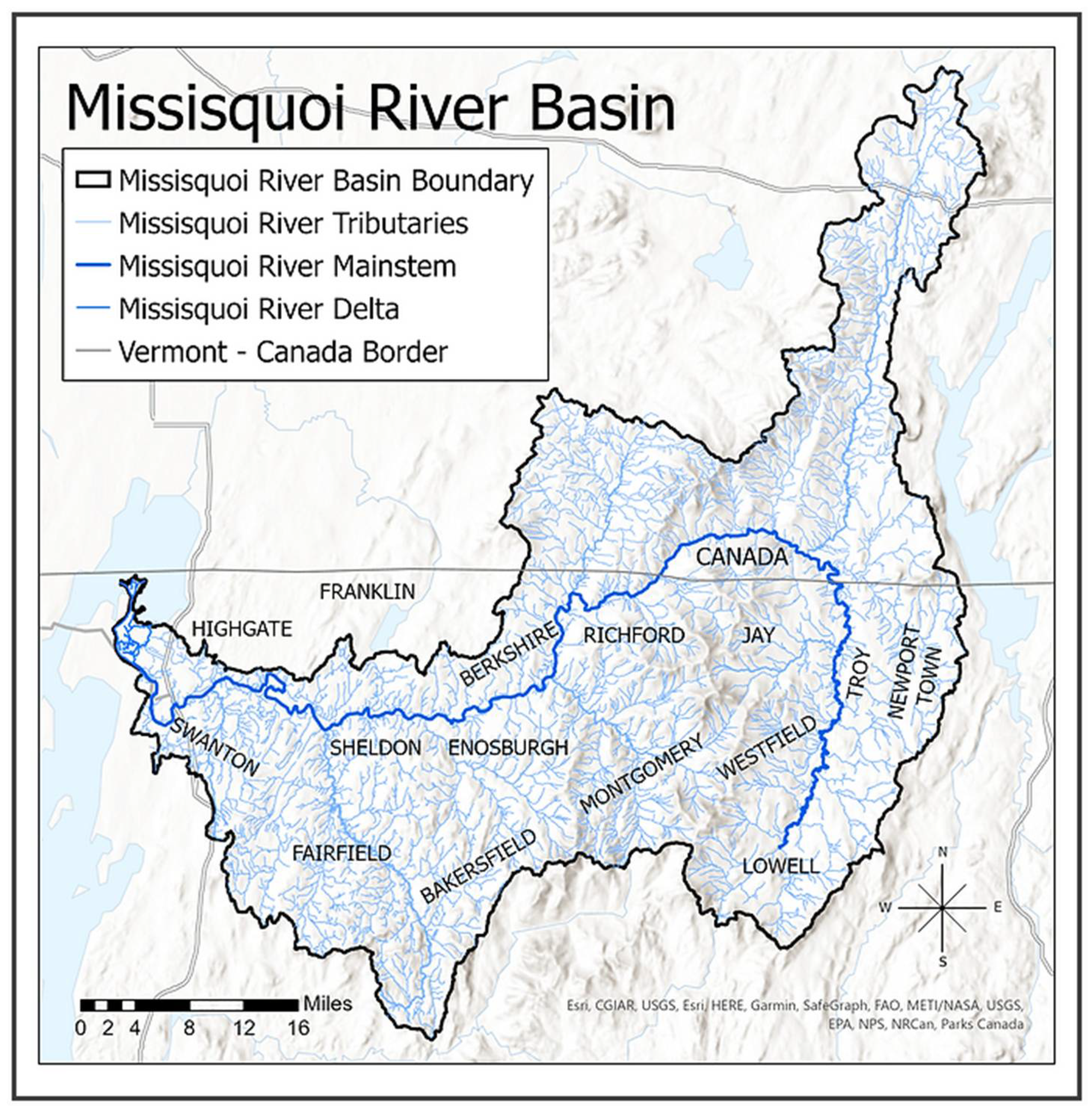
The headwaters of the Missisquoi River emerge in Lowell, Vermont, USA, and join to form the mainstem that flows north through Westfield and Troy (
Figure 2). These are rural towns, with populations of 887, 534, and 1722, respectively. Dairy farming and other forms of agriculture, maple sugaring, and logging comprise the key land-based activities, although many of the residents commute to jobs in more populated areas. After passing through Troy, the 88-mile-long waterway enters Canada, loops back into Vermont, and eventually drains into the Missisquoi Bay of Lake Champlain [
1] (
Figure 2). In 2014, 46.1 miles of the Missisquoi and Trout Rivers—including the segments in Westfield and Troy—were federally recognized as Wild and Scenic, a designation that serves to protect the outstanding natural, cultural, and recreational values of certain rivers [
32].
The Upper Missisquoi River is abutted by a mix of conserved and non-conserved farmland, forests, residential land, and small-town developments. As a wild river, the Upper Missisquoi is dynamic; it floods fields, cuts into farmland along the riverbanks, and, in some cases, re-routes through fields after a flood event. Even though the study area is neither highly developed nor densely populated, its waterways have faced the impacts of human disturbances, including erosion and nutrient loading from agricultural practices and altered hydrology and flood patterns from active river management strategies, which in turn affect Lake Champlain.
Agricultural lands account for 38% of the annual phosphorus (P) loads into Lake Champlain, and the outlet of the Missisquoi River contributes one third of all nonpoint-source P to the lake [
1,
33]. The high level of P loading into Lake Champlain and the resulting cyanobacteria blooms significantly harm the ecosystem services of the lake and are a critical concern for the present and future of the lake’s water quality [
33]. The path to improving Vermont water quality relies on the combined efforts of several national, federal, state, and regional private and public organizations. A subset of the state of Vermont’s DEC, the Vermont Rivers Program (VRP), strives to manage, protect, and restore the natural geomorphic conditions of waterways; to avoid conflict between human investments and river dynamics; and to lessen the consequential economic and ecological losses [
34]. Hydrologic alterations from traditional, active forms of river management, such as channelization and dredging, have historically increased flood damages downstream [
26]. In recent years, the VRP transitioned to a passive geomorphic approach to river management that embraces the dynamic and deformable nature of waterways, employs conservation as a restoration tool to avoid further investments within river corridors, and allows the waterways to naturally equilibrate [
26,
34].
River corridor easements—which involve the transfer of channel management rights to a land trust, prohibition of new structures in the river corridor, and establishment of a minimum 50-foot vegetative buffer of native woody vegetation—serve as the VRP’s central tool for reducing channelization and mitigating damage [
26,
27]. Vermont land is mostly privately held, and easements provide a financial incentive to landowners to facilitate passive restoration of waterways on their property. While scientific evidence and geological assessment support nature-based river restoration approaches, the social impacts for those living and working on Vermont’s rivers and streams have yet to be extensively assessed, a gap which this case study works to address through interviews with riverside landowners and piloting PVZs as a qualitative research method.
2. Materials and Methods
This case study employed mixed qualitative research methods, including participant observation, interviews, and photovisualization. The use of qualitative research methods is well suited to this project, which aims to better understand the non-material functions of riverine landscapes that are difficult to quantify [
3,
35,
36]. Qualitative research seeks in-depth experiences with participants and the study area in order to trace the complex, affective relationships between these variables. Rather than surveying a large number of people in an attempt to develop a sample of responses that are representative of a broader population, qualitative studies seek rich narratives, and these methods require time-intensive engagements between the research and a relatively small number of participants. This study was reviewed and authorized by the University of Vermont Institutional Review Board, using the exempt procedures set forth under 45 CFR 46.104 (STUDY00000387). All participants gave their informed consent for inclusion prior to their interviews, and they are represented by pseudonyms.
2.1. Participant Observation
Author 1 participated in twenty hours of community events and recreational activities on the Missisquoi River in order to gain familiarity with the study area. These activities included attending organizational meetings, paddling the river, and tabling at town events. She took detailed fieldnotes while engaging in these activities, strengthening her connection to the Upper Missisquoi River Basin [
6]. She also formed connections with local water quality advocates and conservation professionals, which facilitated contacts with potential interview participants.
2.2. Interviews and Photovisualization
Initially, Author 1 conducted four informational interviews with water conservation officials in state agencies and conservation professionals in non-profit organizations. These conversations, about four hours in total, provided background information on the water quality initiatives and conservation efforts occurring within the Upper Missisquoi River Basin and throughout the state of Vermont but are not emphasized in the results herein.
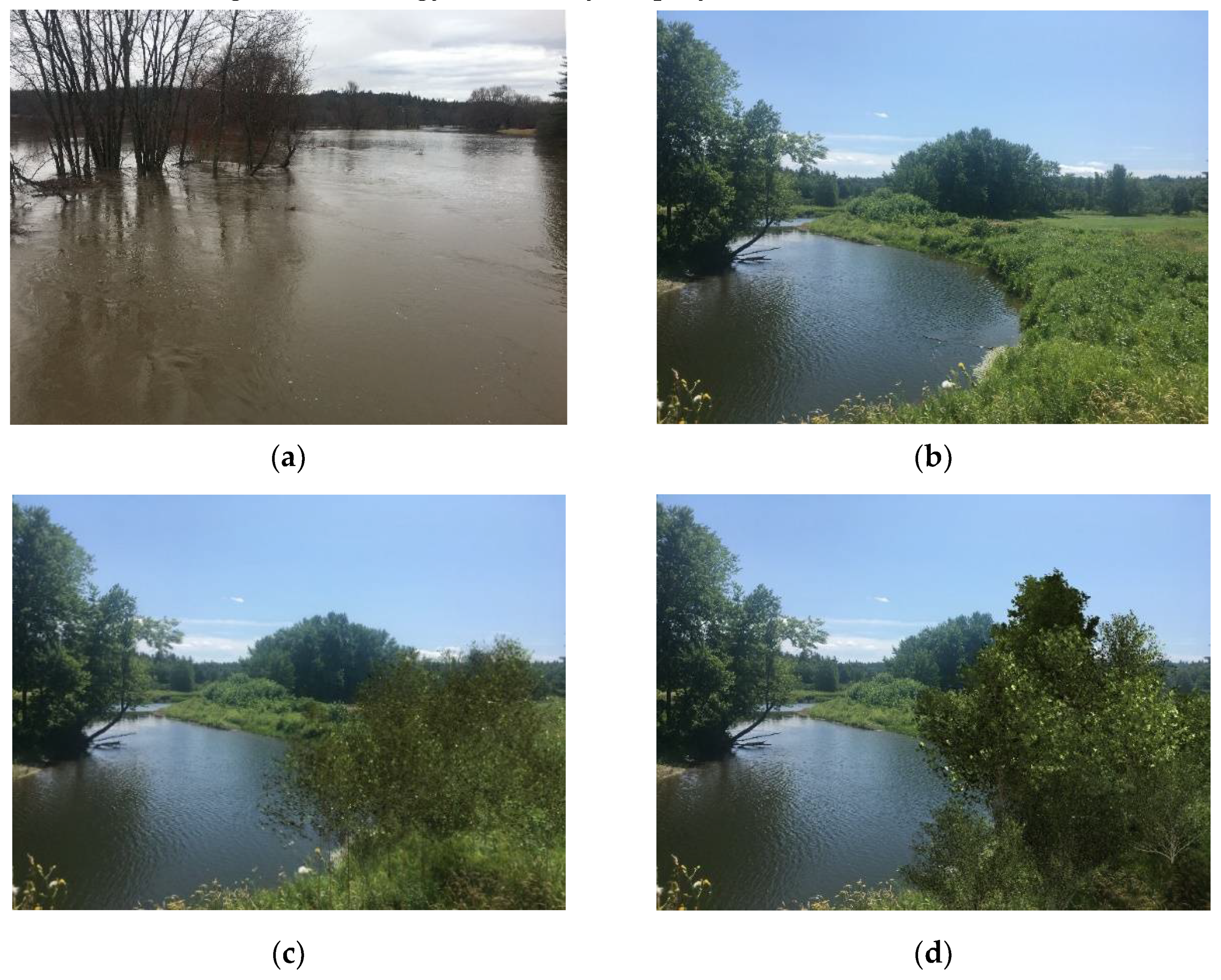
In 2019, Author 1 conducted semi-structured, in-person interviews (some in pairs) with eighteen individuals who live, work, and/or own property along the Missisquoi River and/or its tributaries in the study area. The interviews ranged from 45 min to 90 min in length, for a total of 17 h of interview-based data collection. The interviews included questions about the participants’ engagement with the Missisquoi River and its tributaries, experiences with flooding events, river management options, and participation in river conservation efforts. At the end of each interview, Author 1 presented participants with a series of four, static photovisualizations (PVZs) of a single location on the main stem of the Missisquoi. The PVZs showed a “real” photo of the location under flooded conditions in April 2019 (
Figure 3a), and a “real” photo of the location under “normal” conditions with the water within the riverbanks in June 2019 (
Figure 3b). Adobe Photoshop was used to alter the image in
Figure 3b, depicting a juvenile vegetated buffer (
Figure 3c) and a mature vegetated buffer (
Figure 3d) [
15,
22]. Each image was printed on 10 × 13-inch paper and laminated. Thus, the participants could “see” what this section of the river would look like with an established vegetative buffer zone, a passive river management strategy commonly employed in Vermont.
Sixteen of eighteen participants viewed the PVZs. One couple did not review the PVZs due to time constraints on the interview. After explaining how the PVZs were made and what they represented, the participants were prompted to share their immediate responses to the images. If needed, they were asked further questions to stimulate discussion, such as “Which photo(s) would you classify as a healthy river?”, “Can you please rank the photos from most preferred to least preferred scenario and explain your choices?”, and “What parts of each photo do you like or dislike?” In addition, participants were asked if they had engaged with PVZs before; if they had any recommendations to improve the images, and if they believed the visuals could aid in the communication of conservation initiatives.
2.3. Data Analysis
All interviews were digitally audio recorded and transcribed using HyperTRANSCRIBE and NVivo [
37,
38]. Authors 1 and 2 created a preliminary coding system to serve as a guide [
39]. The coding focused on latent content analysis [
39]. We followed a similar method to Schattman et al. (2019): Using the version of grounded theory as proposed by Glaser (1992), we did not approach the data with a rigid hypothesis [
15,
40]. Instead, we sought out themes that came from the transcripts, most of which superseded the categories of the preliminary coding system. When important codes emerged in later interviews, the authors returned to prior interviews to search for converging or diverging trends.
2.4. Participants
We conducted eight interviews with individuals alone and five group interviews, four with married heterosexual couples, and one with a mother and son duo. Ten of the participants were female, and eight were male. The participants’ ages ranged from 22 years to 87 years. Nine of the participants own land along the Missisquoi’s mainstem, and four others farm on land interwoven with both the mainstem and tributaries. Four interviewees live alongside one or more headwaters or tributaries to the Missisquoi. Thirteen of the eighteen participants are involved in agriculture in some capacity. The five participants who are not professionally engaged with agriculture all interact with the land on a daily basis, rarely leaving their properties as a result of either their business operations or chosen lifestyle.
3. Results
3.1. Appreciation for the Missisquoi’s Dynamic Role in the Landscape
Our research participants reported multidimensional and dynamic relationships with the waterways that run through their properties. George is a dairy farmer who has lived in the area since the 1960s. He started farming his riverside land in the 1970s, and his parents farmed the land before him. George described his connection with the Missisquoi River as a “love-hate” relationship; it provides both benefits and hardships, depending on the intensity of the weather and resulting flood events. His case offers just one example from the eighteen personal accounts of appreciation and respect for the river’s powerful presence in the landscape. George explained how his appreciation for the river grew, as a result of his involvement with the Wild and Scenic study:
I kinda got involved with [the Wild and Scenic study] because I was a little bit leery about the whole thing. I wanted to see what people were up to. But what happened though is that I fell in love with the river in the process—or I realized how much I love the river, maybe I should say. I had grown up with it. I respect it and love it, and we have been happy to share it with other people. And in this process of getting the Wild and Scenic designation, we ended up celebrating a jewel that was right here in front of us.
George remains involved with the Wild and Scenic committee and a strong advocate for the waterway’s many functions. Five other participants also mentioned the Missisquoi River’s Wild and Scenic status, their subsequently increased awareness of the river’s benefits, and their support of local conservation efforts through volunteering or allowing water quality projects to occur on their property.
As recognized by the Wild and Scenic designation, the participants expressed strong appreciation for the river’s beauty and the recreational outlets it provides. All eighteen participants mentioned recreational activities involving the river and its tributaries, including fishing, foraging, walking, paddling, and playing with children or dogs. The waterways provide peace and solace to many of the participants. Kerry, a farmer who has lived by the Missisquoi’s tributaries for over 25 years, nostalgically recalled the waterways as a place of peace while child raising:
When the kids were babies, I would bring them [to the water] just as a soothing presence and look at all the little… wood fairies and water nymphs. It was a place of joy and creative imagination. A trickling brook is very soothing, so as a mom of newborns, I often found solace there. Quiet.
Proximity and time with a waterway connect people to their surroundings, from the scale of an individual species to that of the entire watershed, linking people to the land parcels and water systems up- and downstream. An example of the species scale comes from Dianne, a farmer, whose encounter with a “strange looking duck” and her ducklings, during her first time paddling on the river, stimulated her to go home and learn more about the species. At the larger scale, Jake, a resident by the headwaters of the Missisquoi, expressed:
Often when [the children] were little, we sat on the bridge down here. Remember that? [We would] imagine how long it would take for the water that’s flowing by us right now on this little brook to get to the lake. All the way up and around and out into the lake.
As George suggested, while the participants emphasized the positive, “loving” aspects of the riverine landscape, they also revealed negative emotions toward the river. Every participant shared fear and concern with regard to the waterways’ unpredictable movements and flood damages. The participants recounted memories of flood events that swept buildings and bridges away, spoiled crop loads, stole valuable cropland, and carried hay bales downstream. These observations introduce the notion that relationships with the river shift over short and long temporal periods, just as the river shifts its course.
3.2. An Evolution over Time
The interview data suggest that temporality strongly influences people’s relationships with riverine landscapes and nature in general. George’s relationship with the Missisquoi developed and changed over the 50 plus years that he has lived and worked on that land. For almost every participant, strong bonds with the Missisquoi’s landscape were strengthened by time and familiarity. Fifteen out of eighteen participants have spent more than twenty years living and working on the riverside land. As a result, the landscape holds a greater meaning: it is part of their sense of home. The river and the surrounding land are linked to the participants’ families—and for farmers, to their livelihoods.
When asked how long he lived on Missisquoi, Pete responded, “Since I was born… I lived down the road probably four miles from here, on the river. And my father lived here. And my grandfather lived, not here, but down where it’d flood a lot”. He then said, referring to the property, “My kids are gonna be here when we’re gone. They’re gonna have all this. This is not getting sold”. Dale and Martha, a married couple of farmers who have lived and worked in the area for nearly 25 years, described their riverside land as a source of food and support for their family.
The participants who spent less time on the river or in the area did not have as many river tales to tell. One was Finn, an agricultural consultant, who has worked with a riverside farm in the study area for over ten years. Finn shared some recreational experiences that he has had on the river; however, he mainly spoke of the shifting river management practices in Vermont. Finn’s policy-focused tone contrasted with the nostalgic, reflective tone of many life-time river dwellers. Two others, Albert and Dianne, have lived in the study area for over twenty years, but they only started haying river bottom fields recently. When directly asked about their relationship with the Missisquoi, Albert responded, “Well, you see, it’s only been since like 2016 that we’ve had the river bottom that we got now down there”.
Many participants, such as George, directly cited changing perceptions of the waterways over time. Jess, a former resident and farmer in the region, described the shifts in her relationship with the watershed as she grew up:
I interacted with the headwaters in a recreational [way], kinda like hunting, fishing, making a living, sugaring, growing up there. And then I actually spent time down alongside the Missisquoi through a more agricultural lens and that just kinda made my experience with the watershed more comprehensive. You know going from it’s a proximity, it’s a home sort of, childhood memory sort of thing and then like okay so now it’s changing to like it’s influencing the way that we create revenue.
Haley, a life-long dairy farmer in the area, described a change similar to Jess’s account. When she was a child, Haley would interact with the river recreationally; after growing up and farming her own river bottom land, she gained a different understanding. She explained, “Now, we just respect [the river]. That’s what I would say”.
These experiences convey how engaging with the waterways from many different angles can lead to a deeper relationship and an acknowledgement of the Missisquoi’s multifunctional role in the landscape.
3.3. Shifts in River Management Strategies and Local Adoption over Time
The research participants reported a noticeable increase in the frequency of flood events over the past 30 years. As Dale stated, “The old timers used to tell us when we first got here…we’d have a flood, and they’d say, ‘Don’t worry about it. It’s only what they call a ten-year flood.’ But I think we get a ten-year flood every year now”. These landowners offer an important perspective on intensifying, long-term weather patterns, due to their position in the floodplains and the many years they have lived and worked there. As riverside dwellers and workers, they bear both intimate witness and harsh impacts from the effects of climate change.
Meanwhile, riverside landowners have also experienced shifts in river management and conservation strategies over time. The older research participants in this study recalled when it was more common to stabilize riverbanks with rip-rap, to dredge the river bottom, and to rely heavily on chemical fertilizers. Although accepted river and agricultural conservation practices have transitioned significantly, landowners and conservation professionals are still contending with the impacts of previous actions and long-held opinions.
The study participants were unanimously aware of Vermont’s shift from active to passive river management techniques. They discussed how previously approved practices still impact the landscape. For one, legacy phosphorus (P) maintains high P levels in certain farm fields due to historically excessive nutrient application and P’s physical and chemical properties. George recalled that the federal government would encourage farmers to mix a chemical fertilizer called “super phosphate” in with their liquid manure slurry. He theorized, “A lot of the phosphorus problems that we have today probably date back to some of that because phosphorus doesn’t just go away”. Other past actions or factors referenced by participants that still impact the landscape include rip-rapping, pre-existing infrastructure, logging practices, and prior lack of zoning.
Participants expressed worries and doubts with regard to the passive river management strategies, citing the drastic change in messaging from conservation organizations. Dale, a dairy farmer, wondered, “Is what they’re [doing] gonna work ten years from now? Are they gonna change the philosophy again on how they’re gonna manage the river?” This participant and his wife are the only two people we interviewed who pursued a river corridor easement, a sign of support for passive river management; however, they still expressed uncertainties about the effectiveness of this strategy. Dale asked, “Is this actually gonna increase water quality by selling it? We’re so far removed from the scientific part of it. Someone along the way must’ve realized that this is the right way to make the water quality better, to protect the river corridor”. Another participant, Haley, similarly questioned the practice of allowing rivers to meander: “But what are the negatives if the river doesn’t move?... Is there a negative of not letting the nature of the river move?” These doubts demonstrate the need to build trust with landowners through improved outreach and education.
Some participants saw the passive approach to river management as “giving up” valuable farmland, as flooding events have eroded chunks of farmland. This view shows how difficult it is for a landowner, especially a farmer, to accept the loss of their property. One farmer said, “It’s so hard to look at [the land] and say well we’re gonna give that up because that’s just what we’ve been programmed to do [to] get the most product off the land that we can. And generally, our land next to the river is our most productive land”.
When asked about the benefits and barriers to the easement program, nine participants offered the same, most significant hurdle: the need for enough acreage to feed their cows and spread their manure. For farmers, the fields themselves serve a diverse array of functions that money simply cannot replace. Already, the river’s battering force and unstoppable floods may threaten this land, by eroding banks and spoiling crops. One participant stated, “I wouldn’t want to do [the river corridor easement]. No, not for me because we need the land… 50 feet’s a lot of land”. Finn, the agricultural consultant, highlighted one of the farmers’ core concerns about putting land in an easement: “Money’s fine. But money doesn’t feed my cows”.
Meanwhile, the ability to maintain farms and livelihoods can seem at odds with environmental concerns downstream. Jess explained, “[farmers may] feel removed from the phosphorus load in Lake Champlain and other environmental catastrophes… [They] care. No, it’s not only [about the] money, but sometimes that’s where the river meets the road for a lot of these people”.
Despite their concerns about the easement program, the participants also shared a range of positive and accepting responses toward the new river management strategies. One dairy farmer, Bill, suggested, “I think what you’re gonna find is that a lot of people have had ‘conversion experiences’ in the last like at least five years for various reasons”, leading farmers to discard old practices and adopt new ones. The interview data support Bill’s hypothesis with nine tales of changing perceptions towards new river management strategies.
The acceptance levels are increasing as farmers become aware of the multifunctional benefits of conservation practices—and also out of necessity. All twelve farmers and the agricultural consultant described the increase in regulations and inspections over the years, lending towards efforts to adopt conservation practices and maintain compliance with Vermont’s agricultural regulations.
3.4. Photovisualizations: Opportunity for Perspective Representation and Deeper Discourse
PVZs can depict aerial (bird’s-eye) and/or stream-level (human-eye) views of landscapes and stimulate conversations on the pros and cons of proposed landscape changes. The interview participants displayed genuine curiosity about the PVZs, which redirected the attention of the participants and caused them to shift their seated or standing positions. The participants verbally reacted to both the real photos and simulated PVZs. For example, in response to the flooded photograph, Joan exclaimed in wonder, “Oh wow!” and “That’s amazing!” (
Figure 3a). Several participants commented on the aesthetic appeal of the PVZs, calling them beautiful. A few participants reacted positively to the green, open space of the landscape under “normal” conditions (
Figure 3b). While these participants voiced appreciation for the bank stabilization and other functions of the vegetative buffer zones depicted in
Figure 3c,d, they commented on the beauty of the uninterrupted views of the river and adjacent hayfield in
Figure 3b, in contrast to the taller, denser vegetation blocking views of the landscape (
Figure 3c,d).
The majority of participants recognized the location on the river depicted in the photos or asked where exactly they were taken. For instance, George said, “That’s probably right from Route 100 by the bridge, the other side of the bridge of Troy”, and Pete said, “It looks like one of my fields”. Haley, one of the life-time residents, described the PVZs as “home”. Their responses demonstrated their familiarity and connection to the photographed landscape, as they contextualized the pictures within their existing knowledge of the area to help mentally process the proposed scenario.
The PVZs also stimulated stories and discussion, providing participants with central topics—flooding and vegetative buffer zones—for which they could refine their support or opposition. For instance, George responded:
I think this is a good thing right here [
Figure 3c,d], you know, leaving buffers, not disturbing the soil near the river. And in some cases, maybe intervening a little bit with saying, “Okay river you’ve gone far enough here.” … if [the river] starts encroaching too much on either a highway or near somebody’s house or robbing too much farm land from someone.
The PVZs even led to mild debate in the interviews with pairs, suggesting the power of visuals to generate new dynamics and considerations in conversations. In one case, Dale and Martha noticed the juxtaposition of the flooded image (
Figure 3a) with the vegetative buffer images (
Figure 3c,d), causing Martha to doubt the effectiveness of planting trees in flood zones. Dale disagreed, going as far as to search online for aerial views of their property and show where trees had successfully established in a flood zone. His search demonstrated the value of considering both the bird’s-eye and stream-level views, and her response emphasized the importance of depicting realistic scenarios.
When asked to rank the photos in order of preference, the majority of participants preferred the vegetative buffer conditions (
Figure 3c,d); however, a few participants did not place
Figure 3c,d over the other two PVZs, expressing that all the images looked natural and healthy, with or without the vegetative buffer zones (
Figure 3a–d). One participant preferred the current conditions of the river (
Figure 3b), aiming to avoid the loss of productive cropland. This response connects back to the value of land to farmers, while also indicating the importance of including supplemental information with the PVZs, such as the width of the buffer zone.
Overall, the participants expressed appreciation for the photovisualization method, vocally supporting its use in communicating landscape scenarios. Jess explained, “Out of all the forms of communication, visual is sometimes one of the most influential…I think that for a lot of people that might be exhausted by a conversation around this sort of thing that seeing it could be really effective”. PVZs provide a simple and direct way to approach difficult or contentious topics; they can present landscape scenarios and elicit reactions without the use of potentially offensive questions.
Participants offered several recommendations when asked how to improve the effectiveness of the PVZs (
Table 1). These suggestions demonstrate the informational limits of a photograph’s frame and perspective and provide opportunities for future studies.
4. Discussion
The objectives of this research were to better understand the perspectives and attitudes of landowners along the Missisquoi River and its tributaries and to evaluate the effectiveness of photovisualization as a qualitative research method. The rich stories and complex responses of participants illuminated the intricate and dynamic experiences of rural communities in Vermont’s riverine landscapes.
4.1. Performance, Temporality, and the Transition towards Acceptance
The participants’ years of living and working on the Missisquoi and its tributaries have resulted in deep attachments to the riverine landscape. This conclusion contributes to the body of work on the creation of sense of place and cultural identity through performance in landscape [
5,
6,
7,
8,
9]. Participants expressed great appreciation for the Missisquoi’s beauty and wildlife, supporting the power of esthetics [
5,
6]. Despite the challenges and fears presented by yearly floods and extreme weather events, the participants viewed the river system with love and respect. Their value of the landscape’s esthetic beauty surpasses superficial interest and instead represents their deep cultural identities tied to the land [
5,
6].
The interview data also show that these human–nature relationships are dynamic, evolving and growing stronger with time and experiences. The riverine landscape remains in a transition period in both its physical and social dimensions, as participants contend with remnants of past mistakes and move towards sustainable practices and beliefs. The impacts of past management practices endure in both the physical and social layers of the landscape. This notion supports Ingold’s (1993) view of landscapes as records of all those who dwelt there before, in addition to his later use of the term meshwork [
8]. The trails of past actions remain in the landscape, intertwining with the new steps and motions of those who currently dwell there. Furthermore, the human relationships with the land and river have evolved continuously with time, connecting to Ingold’s (1993) discourse on temporality in the landscape.
Each participants’ sense of place, developing over time, has led to a desire to protect the landscape and a gradual trend towards the acceptance of new river management techniques. As Kibler et al. (2018) theorized, attachment to place inspires local landowners to care for the well-being of landscapes, thus ensuring the longevity and success of restoration initiatives. In our case study, the participants’ respect for the land was reflected in their commitment to the long-term good of the community and natural ecosystem. It was also demonstrated by their awareness of the Missisquoi River’s multifunctional values, formally recognized by the Wild and Scenic designation, and their involvement with local conservation organizations such as the Wild and Scenic Committee and the Missisquoi River Basin Association.
At times, participants’ sense of place and intentions to care for the land conflicted with economic needs or mental paradigms. For instance, if a conservation initiative did not also fit in their business model or benefit their livelihood, participants could not fully support it. Additionally, the participants’ doubtfulness toward practices they have not witnessed and trust in practices they have witnessed on the landscape indicate that conservation participation could be increased through the presentation of the tangible, visual benefits of conservation practices [
13,
14,
15,
18,
24,
25].
4.2. Photovisualization as a Useful, Adaptable Communication Tool
The use of still visuals served to increase the engagement and curiosity of the interviewees, aligning with the effects described by Sheppard (2015) and Mould (2019). The photovisualization method stimulated conversation, at times leading to critical analysis and dialogue about the use and effectiveness of vegetated buffer zones. This result further supports the conclusion of Schattman et al. (2019) that PVZs can help to facilitate learning by generating discussion and questions about the pros and cons of the proposed landscape scenarios. As in Mould’s 2019 study, the visual aids invited viewers to see, care, and learn about an “other”—in this case a familiar landscape in a new form—“and become more receptive and empathetic to its past, present and future” [
13] (p. 98).
The PVZs appeared to have a high impact because of their local origins, as participants attempted to identify the location of the photographs. These reactions indicate, once again, that the participants have a strong sense of place in the landscape—one that extends even to a 2D, static image. Aligning with the results from Shaw et al. (2009), our research suggests that PVZs can direct conversation on changes to local, familiar landscapes. Our study did not compare local and non-local images, raising an interesting question for future studies: would a more general, non-local landscape have generated the same amount of curiosity and attention?
The ability of the PVZs to remind the participants of their cultural identity simultaneously speaks to the power of visual esthetics and to the predicted limitations of PVZs; they need to be realistic, credible, and specific to the situation, thus requiring a considerable amount of preparatory work [
5,
6,
16,
22]. For maximum impact, PVZs should be accompanied by other important details, such as the cost, benefits, and context of the depicted scenario [
15,
18,
20,
21].
Similar to the findings of Mould (2019) and Schattman et al. (2020), the visual aids not only served to evoke the landowners’ perspectives towards the depicted landscape and practice, but also to strengthen and expand their viewpoints, as they considered the landscape under different conditions and refined their opinions. The PVZs helped participants reaffirm interview responses, and at points, contrasting with the long-winded explanations to the interview questions, the PVZs stimulated a more concise verbalization of participant beliefs [
13,
15,
18,
26].
The simultaneously artistic and scientific medium enables conservation professionals and landowners to create and view multiple landscape perspectives under various conditions and seasons, thus bridging the gap between presenter and viewer and expanding beyond pre-existing education or place meanings [
13]. For a landowner, an aerial depiction may help link their land-based sense of place to the greater watershed and its resource concerns. On the flip-side, stream-level depictions could connect conservation professionals to the land-based experiences and perceptions of the landowners, revealing deep attachments not only to the “wild” elements of the waterways, but also to the human-modified elements [
13].
4.3. Summary of Findings
Overall, the interviews with riverside landowners acted like springs, brooks, and streams, meandering through the landscape’s topography, converging and diverging on its many opportunities and challenges, and eventually coalescing into several mainstems—or the following main insights.
Time spent and direct engagements in a landscape lead to strong, evolving connections to nature, greater appreciation for its multidimensional services, and unique, relational knowledge of both its beauty and challenges. Attention to temporality yielded insight into the time it takes to develop human–environment relationships, to adapt to new river conservation practices, and to adjust livelihood practices to the dictates of a moving river.
The increasing frequency of extreme weather events places riverside landowners on the frontlines of dealing with the impacts of climate change. Resilient and proactive land management strategies are essential to ensuring their safety and well-being.
The Upper Missisquoi River Basin remains in a transition period from old to new land management and agricultural practices as landowners contend with the consequences of past management approaches and move forward towards more sustainable knowledge and awareness.
Positive perceptions toward new river management practices are increasing with awareness of the Wild and Scenic designation, involvement with local conservation organizations, and knowledge of the multifunctional benefits of riparian areas at both local and watershed scales.
Improved communication on the multifunctionality of these land management strategies and the consideration of different landscape perspectives will serve to connect the goals of various stakeholders.
Photovisualization offers an effective and adaptable tool for communicating landscape change and connecting the perspectives of both presenter and viewer, provided the PVZs are fitted to the local landscape and are accompanied by sufficient information.
These findings demonstrate the value of soliciting the opinions and experiences of landowners to help advance successful conservation efforts. Oliver et al. (2012) state that stakeholder engagement involves informing, learning from, and collaborating with local landowners. These actions lead to the following valuable results: the inclusivity of those directly impacted by the initiatives, the acceptability of proposals due to increased communication and trust, and the improved effectiveness of the end project by using local knowledge to transform science to practice [
28]. Likewise, our results indicate that it is important to acknowledge and learn from the land-based perspectives and strong senses of place of riverside landowners when devising communication strategies and pursuing successful and long-lasting conservation projects [
3,
9,
13]. Future research should apply these findings to developing better outreach among conservation groups and agencies.
Research that is informed by local actors and organizations is more likely to produce findings which are immediately useful to planners and policymakers [
28]. Although this project aims to amplify the voices of riverside landowners in the Upper Missisquoi River Basin, the participants did not have a consistent voice throughout the research process. We recommend working more consistently with community members through participatory action research. Ideally, the participants would take part in all steps of a project’s development, from defining the scope to applying the results [
28].
Photovisualizations offer a powerful tool to open up dialogue about local places and their transformations over time. Designing PVZs for local landscapes could be an opportunity to involve stakeholders in the complete research process, for participants could provide ideas for what to depict in the visuals along with foundational photographs and feedback on the final products.
Finally, we recommend increased interdisciplinary collaboration looking at conservation efforts in riparian areas or other landscape positions critically impacted by climate change. Through a comprehensive literature review or further data collection, ecological and social dimensions of riverine landscapes could be placed in dialogue with one another. This work could constitute a written or visual map of the convergences and divergences of ecological and social functions in a particular region, offering the combined impact of quantitative and qualitative data. Our qualitative lens for this case study, through visits to the river and dialogue with riverside dwellers, has shown us the power of engagement with place in informing how people perceive and respond to ecological change.


