
How Does Quota-Oriented Land Use Planning Affect Urban Expansion? A Spatial Analysis of 280 Chinese Cities


Abstract
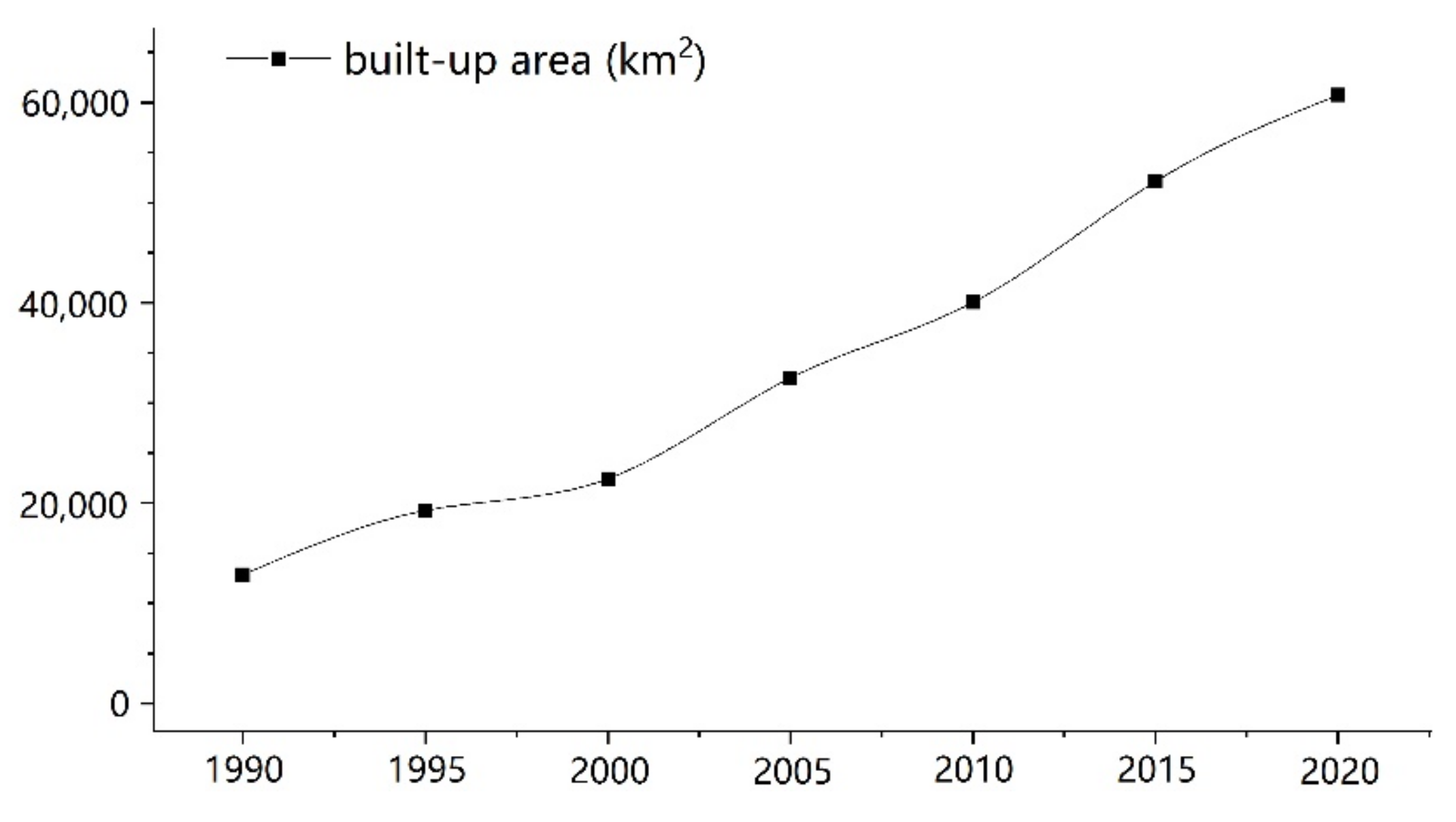
:1. Introduction
2. Background
3. Materials and Methods
3.1. Study Area and Data Sources
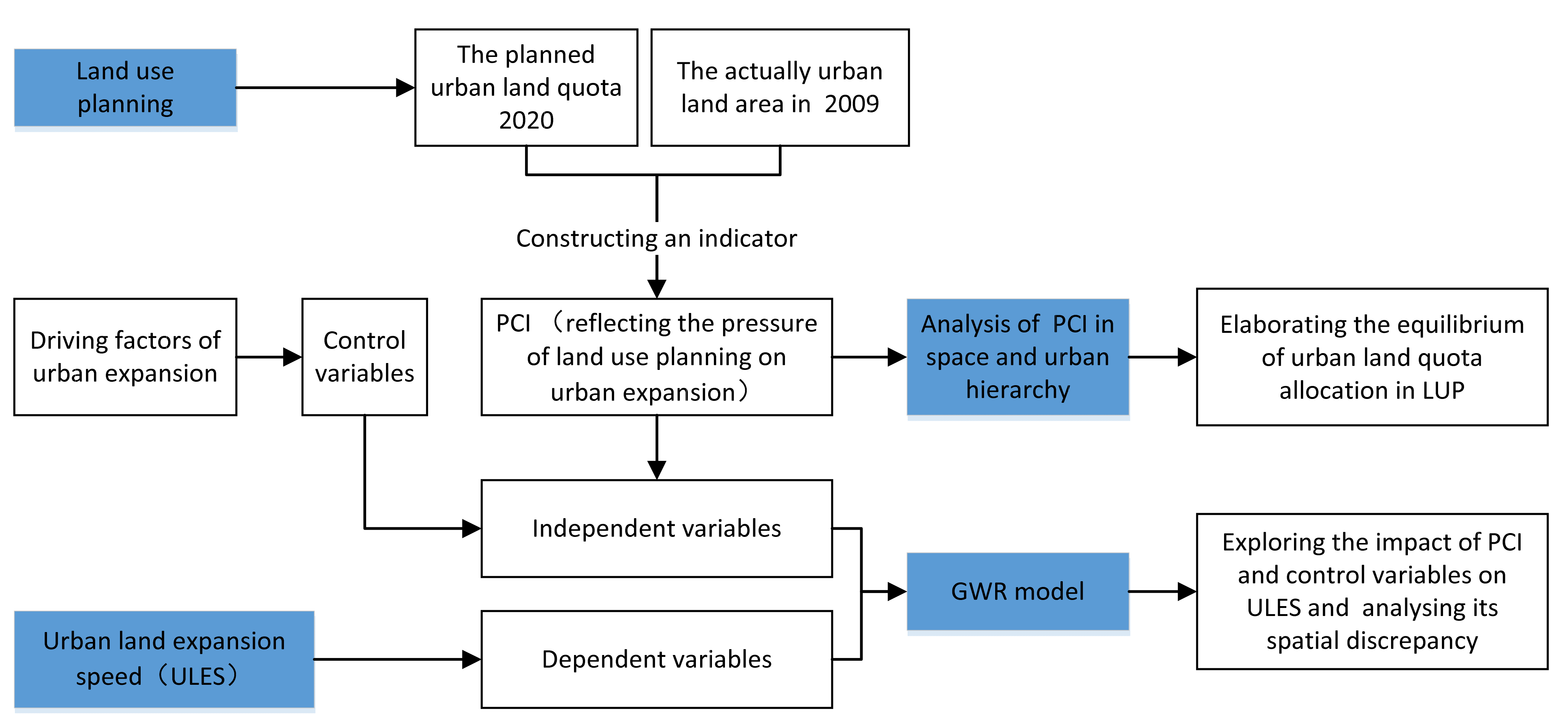
3.2. The Flow Chart of the Methods
- Step 1.
- We design a planning constraint index (PCI) based on the data of urban land quota in 2020 and the actual urban land area in 2009. PCI is taken as the main independent variable of the case study.
- Step 2.
- We perform an analysis of PCI in space and urban hierarchy to expound the equilibrium of urban land quota allocation in LUP.
- Step 3.
- We calculate urban expansion speed (ULES) as the dependent variable to assess the urban expansion pattern.
- Step 4.
- Data preparation for control variables.
- Step 5.
- We conduct an empirical study of 280 Chinese cities using the GWR model to explore the spatial effect of LUP on limiting urban expansion.
3.3. GWR Model
3.4. Variables
4. Results and Analysis
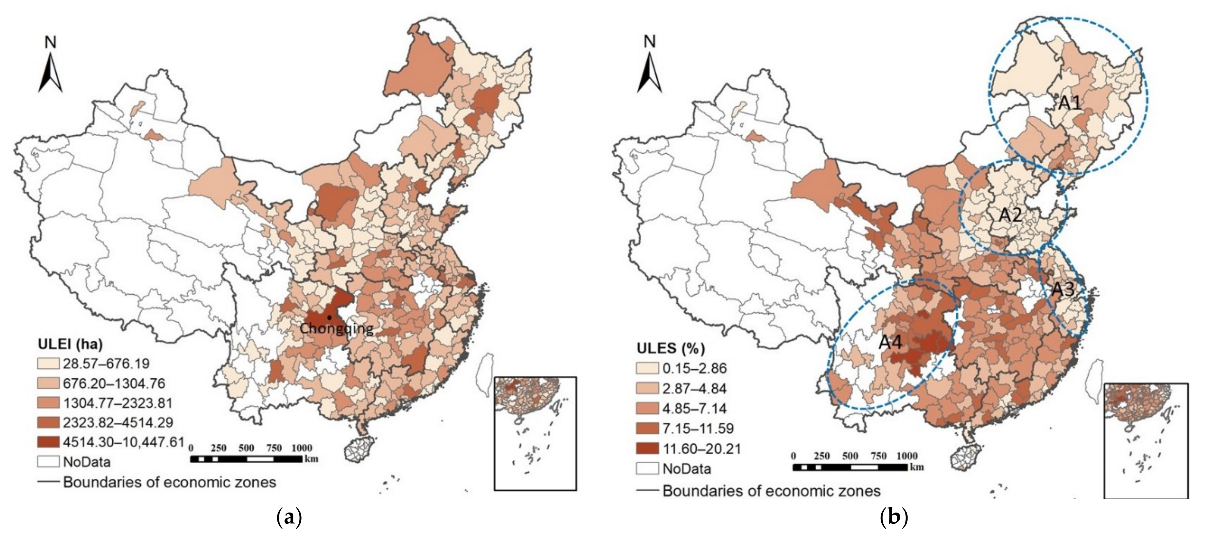
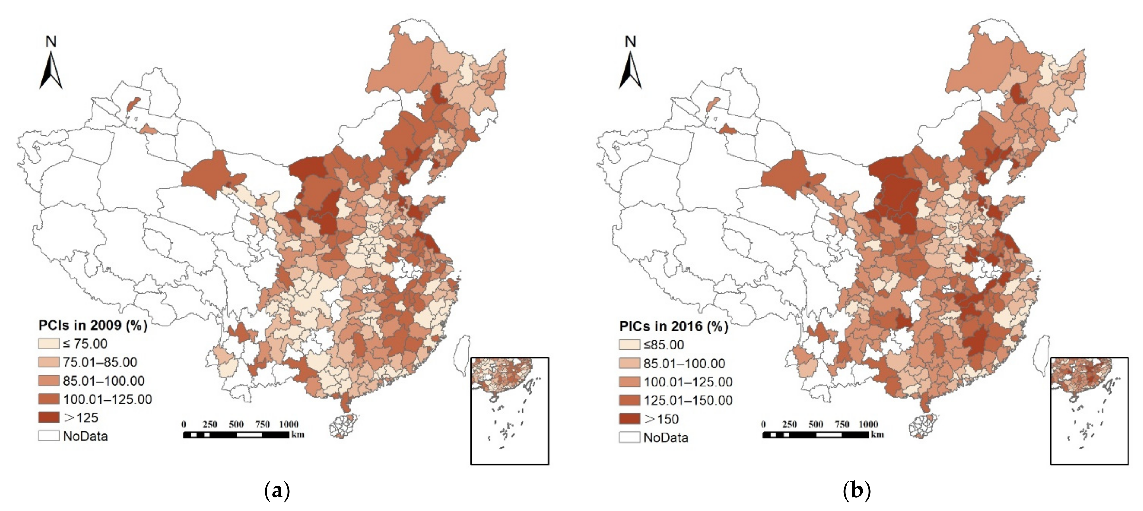
4.1. Spatial Pattern of ULES from 2009 to 2016
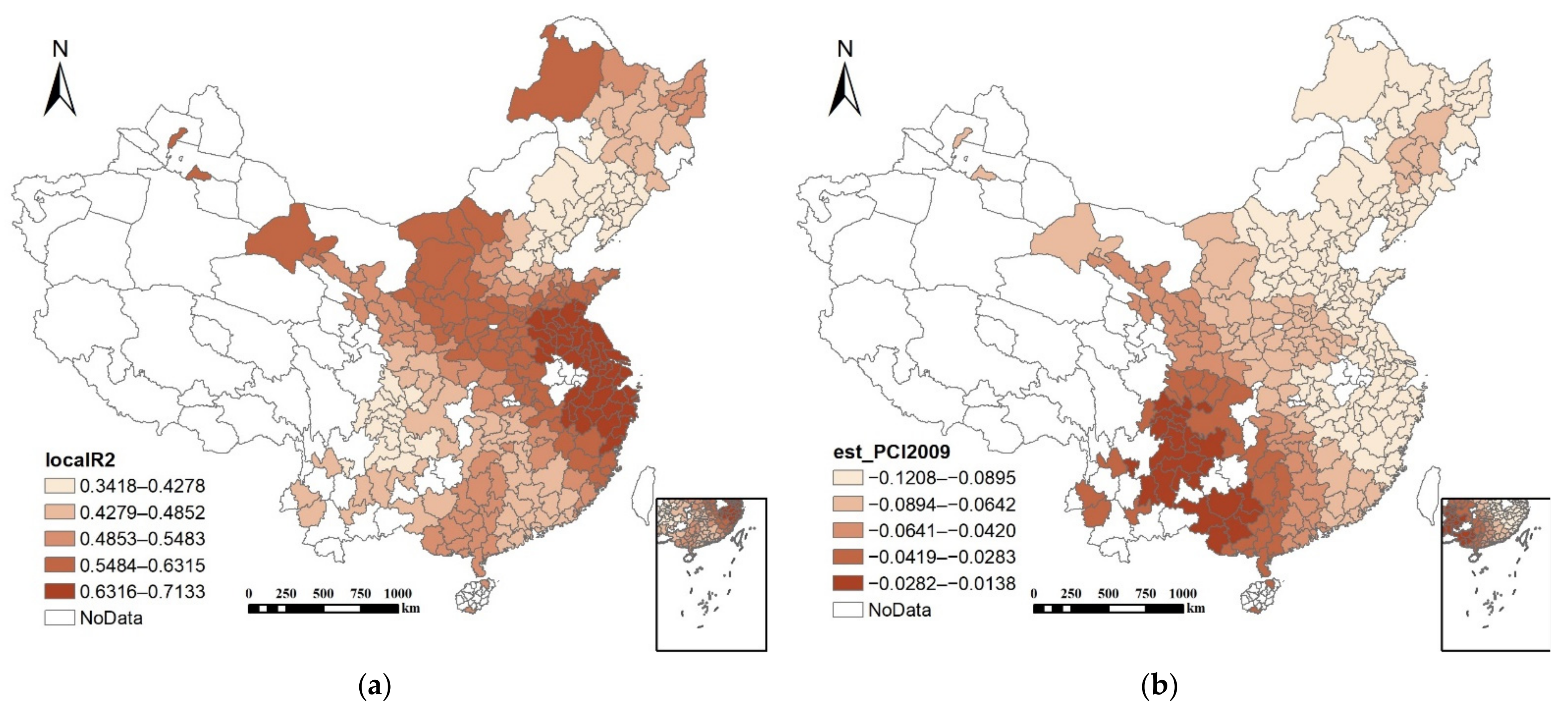
4.2. Spatial Patterns of PCI in 2009 and 2016
4.3. Comparison of Model Performance
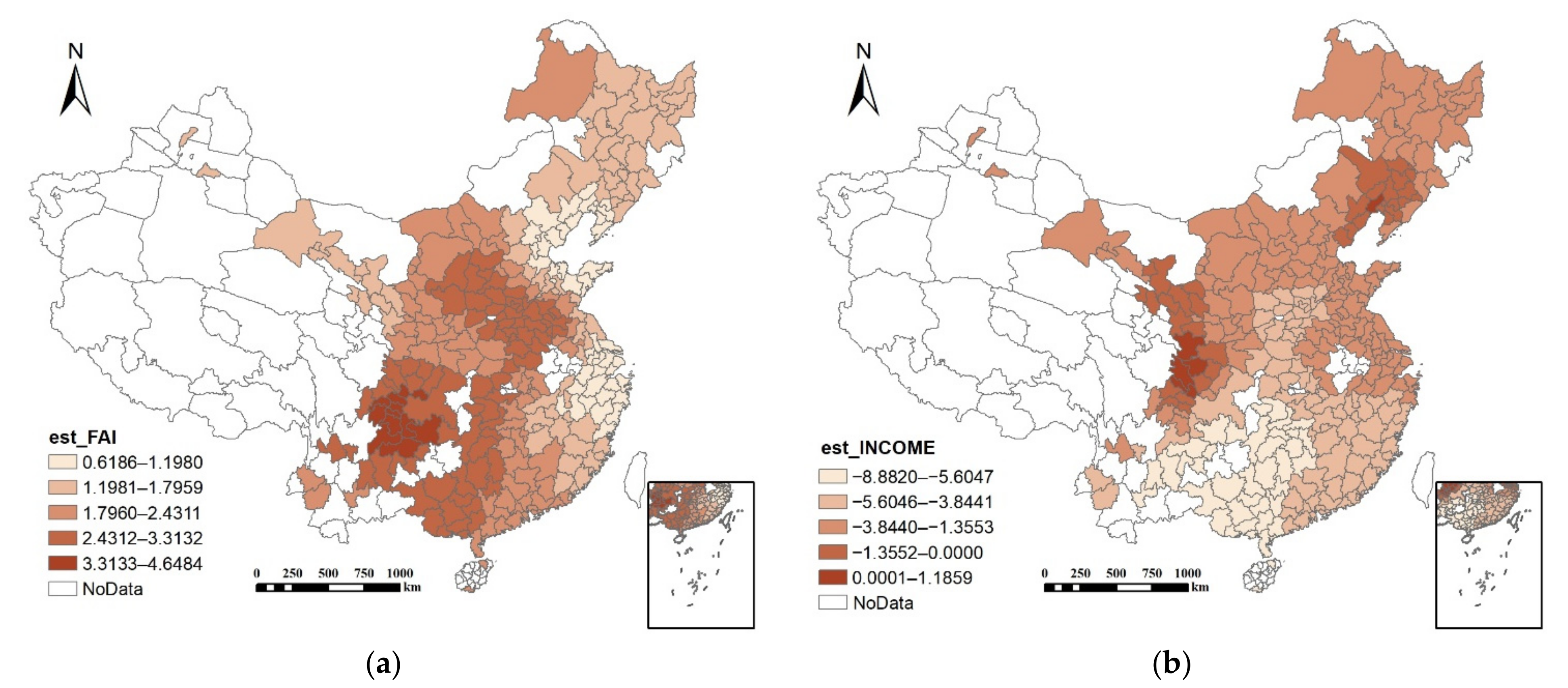
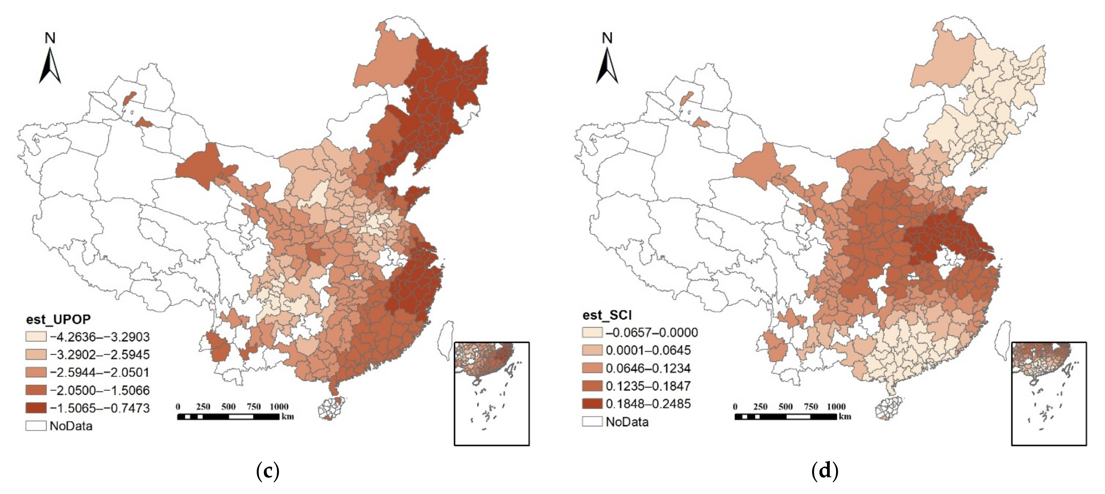
4.4. Spatial Effects of PCI and the Control Variables
5. Discussion
5.1. Urban Land Quota in LUP
5.2. Equilibrium of Urban Land Quota among Cities in Different Regions
5.3. Performance of LUP in Controlling Urban Expansion
6. Conclusions
Author Contributions
Funding
Institutional Review Board Statement
Informed Consent Statement
Data Availability Statement
Conflicts of Interest
References
- Haregeweyn, N.; Fikadu, G.; Tsunekawa, A.; Tsubo, M.; Meshesha, D.T. The dynamics of urban expansion and its impacts on land use/land cover change and small-scale farmers living near the urban fringe: A case study of Bahir Dar, Ethiopia. Landsc. Urban Plan. 2012, 106, 149–157. [Google Scholar] [CrossRef]
- Wei, Y.D. Zone Fever, Project Fever: Development Policy, Economic Transition, and Urban Expansion in China. Geogr. Rev. 2015, 105, 156–177. [Google Scholar] [CrossRef]
- Zhang, Q.; Su, S. Determinants of urban expansion and their relative importance: A comparative analysis of 30 major metropolitans in China. Habitat Int. 2016, 58, 89–107. [Google Scholar] [CrossRef]
- Long, H.; Liu, Y.; Hou, X.; Li, T.; Li, Y. Effects of land use transitions due to rapid urbanization on ecosystem services: Implications for urban planning in the new developing area of China. Habitat Int. 2014, 44, 536–544. [Google Scholar] [CrossRef]
- Wei, Y.D.; Ewing, R. Urban expansion, sprawl and inequality. Landsc. Urban Plan. 2018, 177, 259–265. [Google Scholar] [CrossRef]
- Mckinney, M.L. Effects of urbanization on species richness: A review of plants and animals. Urban Ecosyst. 2008, 11, 161–176. [Google Scholar] [CrossRef]
- Basnou, C.; Alvarez, E.; Bagaria, G.; Guardiola, M.; Isern, R.; Vicente, P.; Pino, J. Spatial Patterns of Land Use Changes Across a Mediterranean Metropolitan Landscape: Implications for Biodiversity Management. Environ. Manag. 2013, 52, 971–980. [Google Scholar] [CrossRef]
- Abrantes, P.; Fontes, I.; Gomes, E.; Rocha, J. Compliance of land cover changes with municipal land use planning: Evidence from the Lisbon metropolitan region (1990–2007). Land Use Policy 2016, 51, 120–134. [Google Scholar] [CrossRef]
- Lemonsu, A.; Viguié, V.; Daniel, M.; Masson, V. Vulnerability to heat waves: Impact of urban expansion scenarios on urban heat island and heat stress in Paris (France). Urban Clim. 2015, 14, 586–605. [Google Scholar] [CrossRef]
- Tian, P.; Li, J.; Cao, L.; Pu, R.; Wang, Z.; Zhang, H.; Chen, H.; Gong, H. Assessing spatiotemporal characteristics of urban heat islands from the perspective of an urban expansion and green infrastructure. Sustain. Cities Soc. 2021, 74, 103208. [Google Scholar] [CrossRef]
- Dewan, A.M.; Yamaguchi, Y. Land use and land cover change in Greater Dhaka, Bangladesh: Using remote sensing to promote sustainable urbanization. Appl. Geogr. 2009, 29, 390–401. [Google Scholar] [CrossRef]
- Liu, Z.; Liu, S.; Qi, W.; Jin, H. Urban sprawl among Chinese cities of different population sizes. Habitat Int. 2018, 79, 89–98. [Google Scholar] [CrossRef]
- Jie, C. Rapid urbanization in China: A real challenge to soil protection and food security. Catena 2007, 69, 15. [Google Scholar] [CrossRef]
- Sharifi, A.; Chiba, Y.; Okamoto, K.; Yokoyama, S.; Murayama, A. Can master planning control and regulate urban growth in Vientiane, Laos? Landsc. Urban Plan. 2014, 131, 1–13. [Google Scholar] [CrossRef]
- Gant, R.L.; Robinson, G.M.; Fazal, S. Land-use change in the ‘edgelands’: Policies and pressures in London’s rural–urban fringe. Land Use Policy 2011, 28, 266–279. [Google Scholar] [CrossRef]
- Gennaio, M.; Hersperger, A.M.; Buergi, M. Containing urban sprawl-Evaluating effectiveness of urban growth boundaries set by the Swiss Land Use Plan. Land Use Policy 2009, 26, 224–232. [Google Scholar] [CrossRef]
- Haeuber, R. Sprawl tales: Maryland’s Smart Growth Initiative and the evolution of growth management. Urban Ecosyst. 1999, 3, 131–147. [Google Scholar] [CrossRef]
- Geller, A.L. Smart growth: A prescription for livable cities. Am. J. Public Health 2003, 93, 1410–1415. [Google Scholar] [CrossRef] [PubMed]
- Song, Y.; Zenou, Y. Property tax and urban sprawl: Theory and implications for US cities. J. Urban Econ. 2006, 60, 519–534. [Google Scholar] [CrossRef] [Green Version]
- Brueckner, J.K.; Kim, H. Urban Sprawl and the Property Tax. Int. Tax Public Financ. 2003, 10, 5–23. [Google Scholar] [CrossRef]
- Talen, E. Success, Failure, and Conformance: An Alternative Approach to Planning Evaluation. Environ. Plan. B Plan. Des. 1997, 24, 573–587. [Google Scholar] [CrossRef]
- Dempsey, J.A.; Plantinga, A.J. How well do urban growth boundaries contain development? Results for Oregon using a difference-in-difference estimator. Reg. Sci. Urban Econ. 2013, 43, 996–1007. [Google Scholar] [CrossRef]
- Zhong, T.; Qian, Z.; Huang, X.; Zhao, Y.; Zhou, Y.; Zhao, Z. Impact of the top-down quota-oriented farmland preservation planning on the change of urban land-use intensity in China. Habitat Int. 2018, 77, 71–79. [Google Scholar] [CrossRef]
- Berke, P.; Backhurst, M.; Day, M.; Ericksen, N.; Laurian, L.; Crawford, J.; Dixon, J. What Makes Plan Implementation Successful? An Evaluation of Local Plans and Implementation Practices in New Zealand. Environ. Plan. B Plan. Des. 2016, 33, 581–600. [Google Scholar] [CrossRef]
- Shen, X.; Wang, X.; Zhang, Z.; Lu, Z.; Lv, T. Evaluating the effectiveness of land use plans in containing urban expansion: An integrated view. Land Use Policy 2019, 80, 205–213. [Google Scholar] [CrossRef]
- Pethe, A.; Nallathiga, R.; Gandhi, S.; Tandel, V. Re-thinking urban planning in India: Learning from the wedge between the de jure and de facto development in Mumbai. Cities 2014, 39, 120–132. [Google Scholar] [CrossRef]
- Mastop, H.; Faludi, A. Evaluation of strategic plans: The performance principle. Environ. Plan. B Plan. Des. 1997, 24, 815–832. [Google Scholar] [CrossRef]
- Behn, R.D. Why measure performance? Different purposes require different measures. Public Adm. Rev. 2003, 63, 586–606. [Google Scholar] [CrossRef]
- Domingo, D.; Palka, G.; Hersperger, A.M. Effect of zoning plans on urban land-use change: A multi-scenario simulation for supporting sustainable urban growth. Sustain. Cities Soc. 2021, 69, 102833. [Google Scholar] [CrossRef]
- Fang, L.; Tian, C. Construction land quotas as a tool for managing urban expansion. Landsc. Urban Plan. 2020, 195, 103727. [Google Scholar] [CrossRef]
- Zhou, Y.; Huang, X.; Chen, Y.; Zhong, T.; Xu, G.; He, J.; Xu, Y.; Meng, H. The effect of land use planning (2006–2020) on construction land growth in China. Cities 2017, 68, 37–47. [Google Scholar] [CrossRef]
- Talen, E. After the Plans: Methods to Evaluate the Implementation Success of Plans. J. Plan. Educ. Res. 1996, 16, 79–91. [Google Scholar] [CrossRef]
- Wang, M.; Krstikj, A.; Koura, H. Effects of urban planning on urban expansion control in Yinchuan City, Western China. Habitat Int. 2017, 64, 85–97. [Google Scholar] [CrossRef]
- Wang, J.; Wu, Q.; Yan, S.; Guo, G.; Peng, S. China’s local governments breaking the land use planning quota: A strategic interaction perspective. Land Use Policy 2020, 92, 104434. [Google Scholar] [CrossRef]
- Li, J. Land sale venue and economic growth path: Evidence from China’s urban land market. Habitat Int. 2014, 41, 307–313. [Google Scholar] [CrossRef]
- Tian, L.; Ma, W. Government intervention in city development of China: A tool of land supply. Land Use Policy 2009, 26, 599–609. [Google Scholar] [CrossRef]
- Fenjie, L.; Ming, G. Research on the Impact of Land Supply on Urban Growth in China. Urban Stud. 2009, 16, 83–87. [Google Scholar] [CrossRef]
- Li, H.; Wei, Y.D.; Liao, F.H.; Huang, Z. Administrative hierarchy and urban land expansion in transitional China. Appl. Geogr. 2015, 56, 177–186. [Google Scholar] [CrossRef]
- NBSC (National Bureau of Statics of China). China Statistical Yearbook; China Statistic Press: Beijing, China, 2021. [Google Scholar]
- UNDP in China. China National Human Development Report 2016. Available online: http://www.cn.undp.org/content/china/en/home/library/human_development/china-human-development-report-2016.html (accessed on 6 March 2022).
- Brunsdon, C.; Fotheringham, A.S.; Charlton, M.E. Geographically Weighted Regression: A Method for Exploring Spatial Nonstationarity. Geogr. Anal. 1996, 28, 281–298. [Google Scholar] [CrossRef]
- Fotheringham, A.S.; Charlton, M.E.; Brunsdon, C. Geographically Weighted Regression: A Natural Evolution of the Expansion Method for Spatial Data Analysis. Environ. Plan. A 1998, 30, 1905–1927. [Google Scholar] [CrossRef]
- Su, S.; Xiao, R.; Zhang, Y. Multi-scale analysis of spatially varying relationships between agricultural landscape patterns and urbanization using geographically weighted regression. Appl. Geogr. 2012, 32, 360–375. [Google Scholar] [CrossRef]
- Chen, W.; Shen, Y.; Wang, Y.; Wu, Q. How do industrial land price variations affect industrial diffusion? Evidence from a spatial analysis of China. Land Use Policy 2018, 71, 384–394. [Google Scholar] [CrossRef]
- Chen, J.; Gao, J.; Chen, W. Urban land expansion and the transitional mechanisms in Nanjing, China. Habitat Int. 2016, 53, 274–283. [Google Scholar] [CrossRef]
- Huang, Z.; Wei, Y.D.; He, C.; Li, H. Urban land expansion under economic transition in China: A multi-level modeling analysis. Habitat Int. 2015, 47, 69–82. [Google Scholar] [CrossRef]
- Li, H.; Wei, Y.D.; Zhou, Y. Spatiotemporal analysis of land development in transitional China. Habitat Int. 2017, 67, 79–95. [Google Scholar] [CrossRef]
- Wei, Y.D.; Li, H.; Yue, W. Urban land expansion and regional inequality in transitional China. Landsc. Urban Plan. 2017, 163, 17–31. [Google Scholar] [CrossRef]
- Huang, X.; Xia, J.; Xiao, R.; He, T. Urban expansion patterns of 291 Chinese cities, 1990–2015. Int. J. Digit. Earth 2019, 12, 62–77. [Google Scholar] [CrossRef]
- Deng, X.; Huang, J.; Rozelle, S.; Uchida, E. Growth, population and industrialization, and urban land expansion of China. J. Urban Econ. 2008, 63, 96–115. [Google Scholar] [CrossRef]
- Zhai, T.; Guo, J.; Ou, M.; Kong, W. Study on allocation of total construction land in Jiangsu Province Based on Gini coefficient. China Popul. Resour. Environ. 2015, 25, 84–91. [Google Scholar] [CrossRef]
- Zuo, W.; Hu, X.; Li, D. The quota allocation method of newly-added construction land based on the bankruptcy model: A case study of Zaoyang city, Hubei province. J. Nat. Resour. 2019, 34, 501–509. [Google Scholar] [CrossRef]
- Liu, Y.; Fang, F.; Li, Y. Key issues of land use in China and implications for policy making. Land Use Policy 2014, 40, 6–12. [Google Scholar] [CrossRef]


| Type | Category | Abbreviation | Description |
|---|---|---|---|
| Dependent variable | Urban land expansion speed | ULES | Average annual urban land growth rate from 2009 to 2016 |
| Independent variables | Land use planning | PCI | The proportion of urban land area in 2009 to the planned urban land area approved in the LUP in 2020 |
| Economic level | INCOME | Log of disposable income of urban households in 2010 | |
| Investment | FAI | Log of total fixed assets investment (annual average 2009–2016) | |
| Industrial restructuring | SIC | Changes in the share of secondary industry in GDP from 2009 to 2016 | |
| Demography | UPOP | Log of urban population in 2010 |
| Regions | ULES | Regional Characteristics |
|---|---|---|
| Northeast China | Low | Labor outflow, aging population, and slow economic development. |
| Eastern Coastal China | Low | High level of urbanization and economic development, advanced industrial structure, and population inflow. |
| Northern Coastal China | Low | Medium level of urbanization and economic development. |
| Middle Huanghe Region | Nonstationary | Covering a large area, with a medium or low level of urbanization and economic development |
| Middle Yangtze Region | High | Medium level of urbanization and economic development. |
| Southern Coastal China | High | High level of urbanization and economic development, as well as population inflow. |
| Southwest China | High | Low level of urbanization and economic development. |
| Northwest China | High | Low level of urbanization and economic development. |
| Range | 0–75 | 75–85 | 85–100 | 100–125 | >125 | Sum |
|---|---|---|---|---|---|---|
| 2009 | 71 | 57 | 78 | 58 | 16 | 280 |
| 2016 | 8 | 30 | 56 | 108 | 78 | 280 |
| Urban Population (Million) | Obs. | Mean Value of PCI in 2009 (%) | Mean Value of PCI in 2016 (%) | Changes in PCI from 2009 to 2016 (%) |
|---|---|---|---|---|
| 0.2–1 | 57 | 90.38 | 119.39 | 29.01 |
| 1–3 | 158 | 90.78 | 114.87 | 24.09 |
| 3–5 | 28 | 90.93 | 107.69 | 16.76 |
| 5–10 | 15 | 77.55 | 94.93 | 17.38 |
| >10 | 6 | 83.57 | 97.65 | 14.08 |
| Sum | 280 | 89.83 | 113.89 | 24.06 |
| Models | R2 | Adjusted R2 | AICc | Residual Sum of Squares | Moran’s I of the Residual |
|---|---|---|---|---|---|
| OLS | 0.3480 | 0.3337 | 1265.2985 | 1436.4360 | 0.2035 |
| GWR | 0.6155 | 0.5187 | 1203.4690 | 847.1720 | 0.0355 |
| OLS | GWR | |||||||||
|---|---|---|---|---|---|---|---|---|---|---|
| Variable | Estimate | Standard Error | t(Est/SE) | P > |t| | VIF | Mean | Min | Max | STD | Range |
| Intercept | 41.692 | 5.915 | 7.050 | 0.000 | / | 39.418 | −0.871 | 87.958 | 17.574 | 88.828 |
| PCI | −0.038 | 0.006 | −6.400 | 0.000 | 1.080 | −0.041 | −0.121 | −0.014 | 0.026 | 0.107 |
| INCOME | −3.223 | 0.752 | −4.290 | 0.000 | 1.630 | −3.388 | −8.882 | 1.186 | 1.929 | 10.068 |
| UPOP | −1.910 | 0.379 | −5.050 | 0.000 | 4.410 | −2.111 | −4.264 | −0.747 | 0.737 | 3.516 |
| CIR | 0.098 | 0.019 | 5.230 | 0.000 | 1.080 | 0.086 | −0.066 | 0.249 | 0.085 | 0.314 |
| FAI | 1.590 | 0.377 | 4.210 | 0.000 | 4.830 | 2.018 | 0.619 | 4.648 | 0.778 | 4.030 |
Publisher’s Note: MDPI stays neutral with regard to jurisdictional claims in published maps and institutional affiliations. |
© 2022 by the authors. Licensee MDPI, Basel, Switzerland. This article is an open access article distributed under the terms and conditions of the Creative Commons Attribution (CC BY) license (https://creativecommons.org/licenses/by/4.0/).
Share and Cite
Zhang, L.; Liu, Y.; Jing, Y.; Zhang, Y. How Does Quota-Oriented Land Use Planning Affect Urban Expansion? A Spatial Analysis of 280 Chinese Cities. Land 2022, 11, 528. https://doi.org/10.3390/land11040528
Zhang L, Liu Y, Jing Y, Zhang Y. How Does Quota-Oriented Land Use Planning Affect Urban Expansion? A Spatial Analysis of 280 Chinese Cities. Land. 2022; 11(4):528. https://doi.org/10.3390/land11040528
Chicago/Turabian StyleZhang, Lingyu, Yaolin Liu, Ying Jing, and Yang Zhang. 2022. "How Does Quota-Oriented Land Use Planning Affect Urban Expansion? A Spatial Analysis of 280 Chinese Cities" Land 11, no. 4: 528. https://doi.org/10.3390/land11040528
APA StyleZhang, L., Liu, Y., Jing, Y., & Zhang, Y. (2022). How Does Quota-Oriented Land Use Planning Affect Urban Expansion? A Spatial Analysis of 280 Chinese Cities. Land, 11(4), 528. https://doi.org/10.3390/land11040528