1. Introduction
Forest fires in the taiga zone are one of the main landscape-forming factors [
1,
2]. Their influence is not limited to only surface conditions, and they have a significant impact on the dynamics of cryogenic processes and the state of permafrost landscapes. Forest fires affect the ground temperature and active layer thickness, with destabilization in the initial period and further stabilization by the development of restorative successions [
3,
4,
5], and in some places, they cause ground subsidence with the development of thermokarst [
6,
7]. In Central Yakutia in recent decades, there has been increased forest fire hazards. Therefore, the study of changes occurring in permafrost landscapes after the surface disturbance has become significant [
8,
9,
10,
11].
The nature of forest fires in Siberia and Yakutia is well-studied [
1,
2]. According to the data of the Forest Department of the Republic of Sakha (Yakutia) for 1955–2005 in Central Yakutia, based on the results of terrain and aviation monitoring, there has been a sharp increase in the activity of forest fires since the early 2000s [
12,
13]. The average burnt area in 2000–2005 was about three times more than in 1955–1999 and about twice that of the long-term average for 1955–2005.
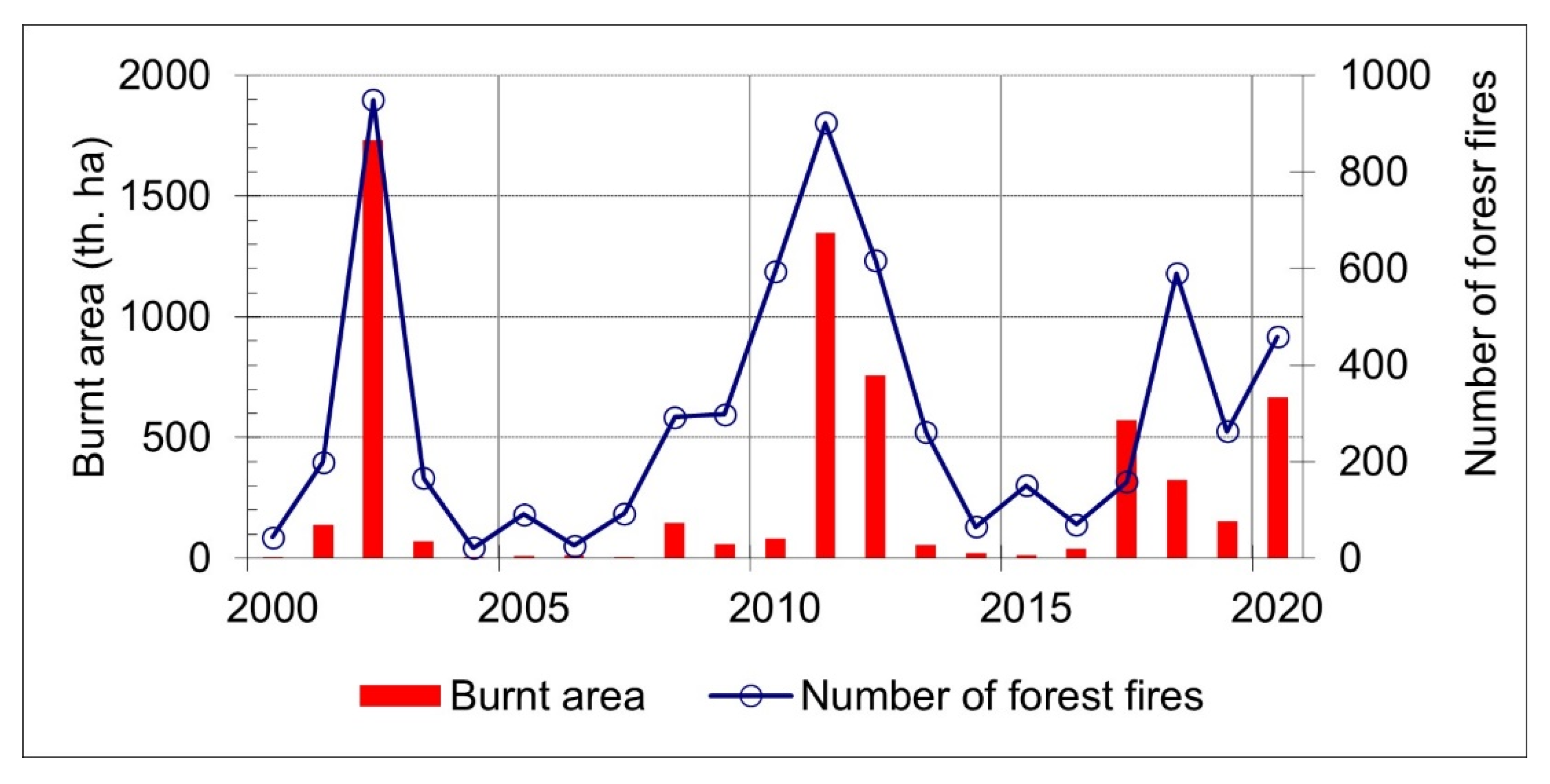
According to the information system of remote monitoring of the Federal Forestry Agency (ISDM-Rosleskhoz) for 2000–2020 (
https://pushkino.aviales.ru/main_pages/index.shtml, accessed on 17 November 2021), the tendency of an increase in forest fire activity in Central Yakutia, including Gorny, Khangalassky, Namsky, Ust-Aldansky, Megino-Kangalassky, Churapchinsky, Tattinsky, Amginsky districts and the territory Yakutsk City, has continued in the current decade (
Figure 1). The total area of these regions of Central Yakutia is 198,850 km
2.
An annual number of forest fires and burnt areas in Central Yakutia for the period 2000–2020 accounts for 300 cases and about 295,000 hectares. In the considered series of years, forest fire activity shows sharp drops. For example, the burnt area in some years differs by about a thousand times. In 2002, 2010–2012 and 2018–2020, there was an increase in forest fire activity. In 2005–2008, there is a period of “calm”. The burnt area in 2002 was more than 1.7 million hectares, which is the highest value during the study period. In 2002, the number of forest fires also reached the highest value for the period under consideration.
The study aims to assess changes in permafrost-landscape conditions after forest fires in Central Yakutia based on an almost 20-year series of data collected in the territory of the Neleger Station of the Melnikov Permafrost Institute SB RAS. It was necessary to solve the following tasks: carry out a spatial analysis of the disturbance by fires and study changes in the climatic conditions, ground temperature, active layer thickness and soil moisture content. In early works on the study of the influence of forest fires, ecologists paid insufficient attention to permafrost dynamics, nor have permafrost scientists paid sufficient attention to the role of successions in the restoration of permafrost conditions. This manuscript makes up for these shortcomings in studies.
2. Materials and Methods
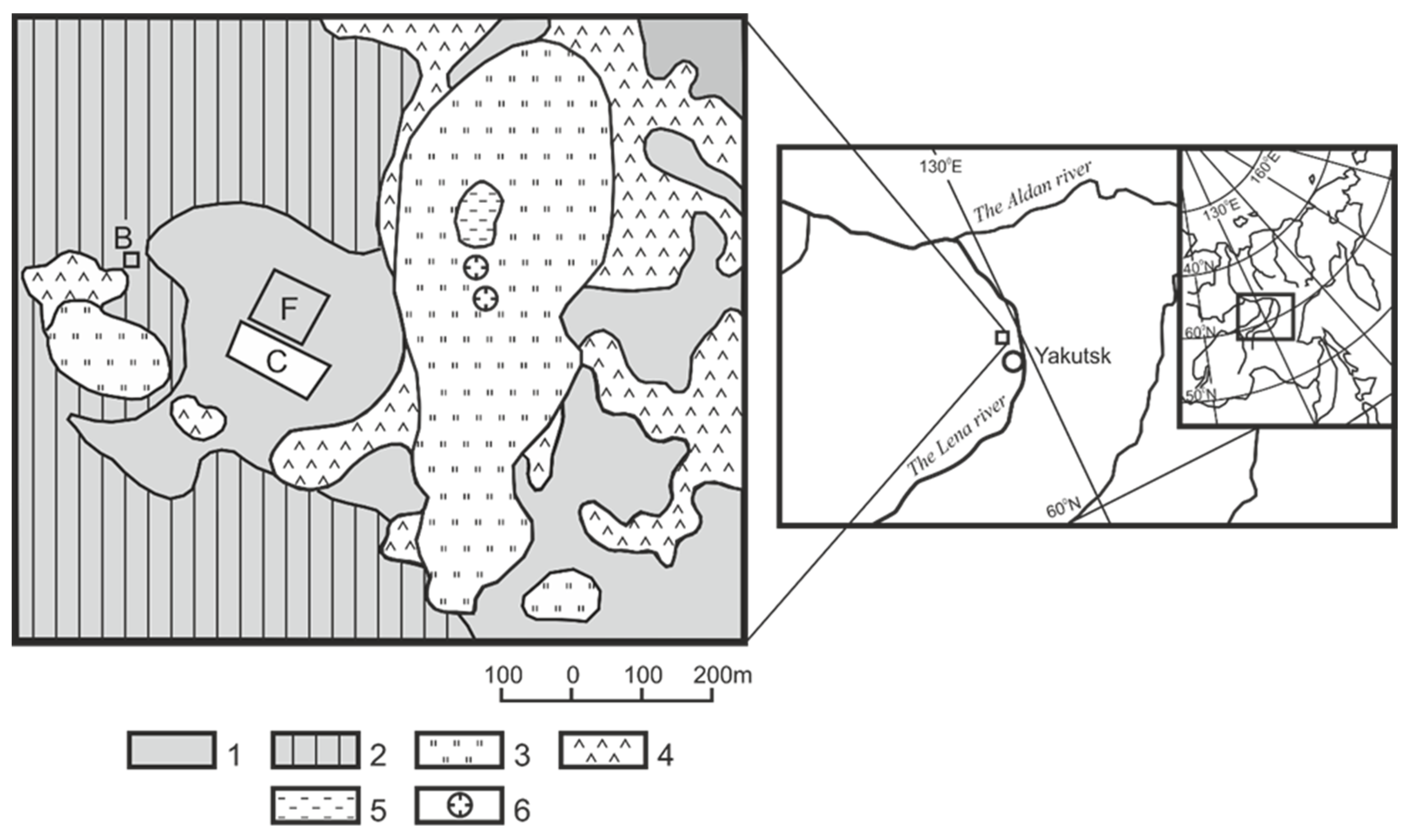
Site descriptions. The Neleger Station, located 35 km northwest of the Yakutsk city, Russian Federation on the left bank of the Lena River, is a typical landscape of Central Yakutia, with an ice complex and a wide distribution of alases formed during the degradation of ice-rich permafrost (
Figure 2).
The studied territory is located on the watershed of the Kenkeme and Lena rivers with an altitude of 200 ma.s.l. Quaternary deposits are represented by ice-rich silty loams with a volumetric ice content of up to 60–80% containing ice wedges [
14,
15]. In undisturbed areas, ice wedges occur at a depth of about 1.5–2 m. The width of the upper parts of the ice-wedge is on average 1–1.5 m. The plan’s transverse dimensions of ground blocks between ice wedges usually do not exceed 5–6 m. Depending on landscape conditions, the active layer thickness varies from 1.2 m in larch forests to 2 m in meadows. The territory under consideration is located in a continuous permafrost zone with a mean annual ground temperature of −1.5—−3.5 °C [
16]. In the Neleger station area, the thickness of the permafrost is estimated to be 400–450 m [
17]. Geobotanically, the region is a typical middle taiga with a predominance of larch (
Larix gmelinii) cowberry (
Vaccinium vitis-idaea) forests [
18]. The surroundings of the Neleger station are a mosaic of different stages of succession after forest fires and cutting in different years.
At the Neleger station in 1999–2008, comprehensive studies were carried out. As a result, new data were obtained on the effect of clear-cutting on the thermal and hydrological regime of the active layer [
19], changes in carbon dioxide fluxes after clear-cutting of larch forest [
20], methane and nitrogen emissions in forest and alas landscapes [
21], variability of evapotranspiration from forest and meadow landscapes [
22] and others. The results of complex physical–geographical, dendrochronological, permafrost and heat-balance studies at the Neleger station were published in a joint monograph with the data from the Spasskaya Pad station [
16]. In addition, the climatic causes of forest fires in Central Yakutia were published by H. Hayasaka [
23,
24] based on research at the Neleger station.
Our observations were carried out at two sites—the area of the forest fire, with undisturbed mature larch forest used as a control. (
Figure 3 and
Figure 4). The control site comprises a larch (
Larix gmelinii) forest with cowberry (
Vaccinium vitis-idaea) undergrowth in the interalas area with ice wedges. Surficial deposits are represented by lacustrine–alluvial sandy loam. The composition of the stand is 10 L (100% covered by larch), and the age is about 100–150 years. The density of crowns is 0.6. In some places, there is a birch (
Betula platyphylla) understory of medium density. The undergrowth consists of willow (
Salix fruticosa) and spiny rose (
Rosa acicularis). The herb-dwarf shrub cover, with a coverage of about 50%, comprises mainly cowberry (
Vaccinium vitis-idaea) and limnas (
Limnas stelleri). Moss cover is rare, and coverage is less than 10% of the forest. Lichens have developed in the form of small spots. The thickness of the forest organic matter is about 3 cm, and the sod layer is 15 cm.
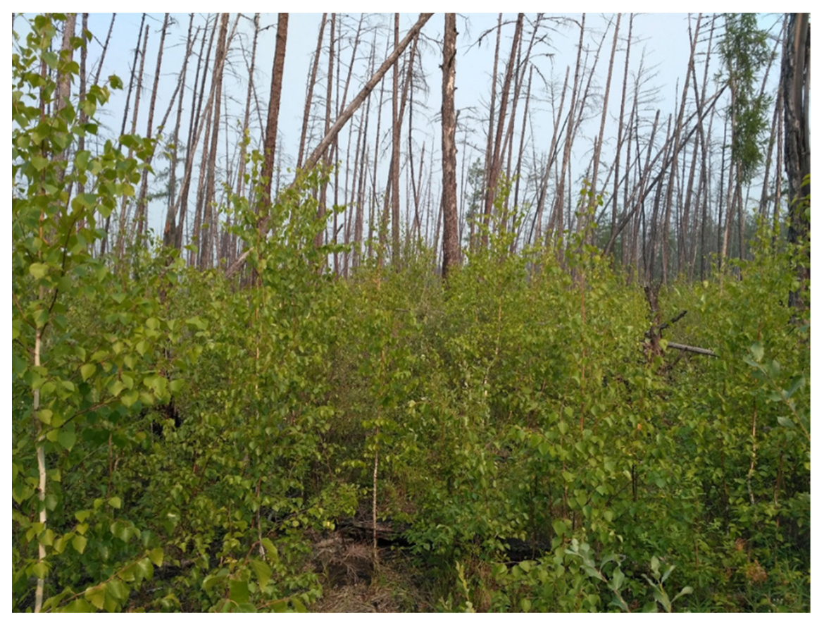
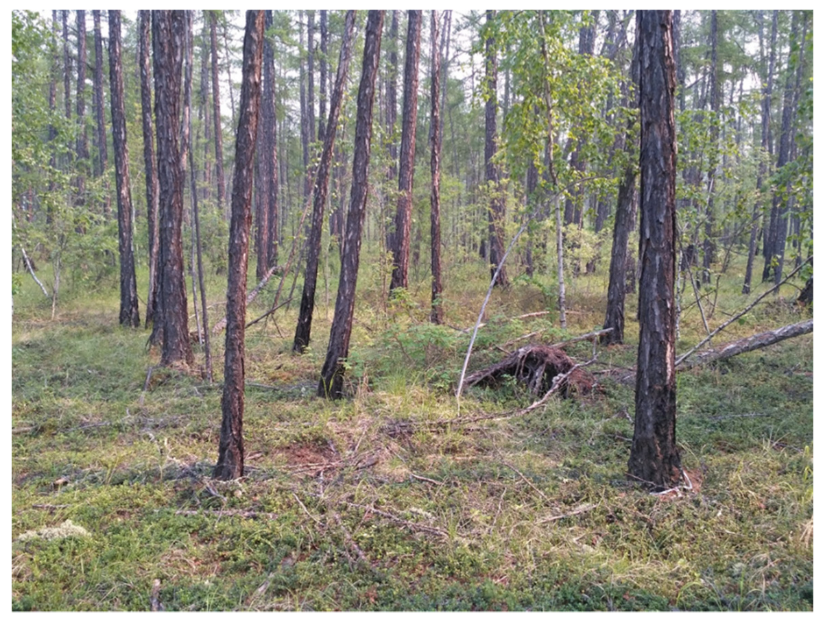
The disturbed area is a burnt site, where there was an intense forest fire in August 2001 and another forest fire in 2012. After the forest fire, the trees mostly fell, but there were a lot of standing deadwoods. For several years after the forest fire, the herb-dwarf shrub cover represented pioneering associations of reed grass and willowherb (Chamerion angustifolium). Willowherb was replaced by a grass association (Calamagrostis langsdorffii). After 3–5 years, there was a change to reed and sedge–reed, forb–sedge–reed associations. Finally, after 7–8 years, the birch understory appeared.
Methods. Measurements were mainly carried out in the summer after the snow cover had melted. The observation period was 2002–2020. The ground temperature was measured in specially equipped wells up to 1.6 m deep, with a backfilled wellbore to eliminate turbulent air exchange [
25]. The measurements were carried out using strings with MMT-1 thermistors (JSC Promelectronics, Ekaterinburg, Russia), twice a month in summer and once a month in winter, on the control site and with automatic recorder TR-52 (T&D Corporation) on the burnt site all year round. The resolution and the accuracy of the MMT-1 thermistors are 0.1 °C. The resolution of the automatic recorder TR-52 is 0.1 °C, and accuracy is 0.2–0.3 °C. The measurement frequency is one hour; the data are taken once a year. Sampling for ground moisture in the active layer was taken every 10 cm with a ground drill, followed by drying the soil sample in a drying oven with a temperature of +105 °C for 8 h in the laboratory. Sampling was carried out twice a month during the summer season. In this work, we used the average gravimetric soil moisture value for the entire active layer every 10 cm at the end of the summer season. Seasonal thaw depths were measured twice monthly during summer using water-filled plastic tubes [
26] and during sampling for soil moisture. In addition, the active layer thickness at the end of summer was measured. The main parameters of the active layer in these two sites were carried out based on a comparative analysis of the data obtained from the disturbed and the undisturbed (control) areas.
3. Results
Almost all landscapes in Central Yakutia have been exposed to forest fires to one degree or another at different times. About 30% of the territory occupied by mature forest can be considered relatively unaffected by forest fires in the Neleger station areas. About 30% of the landscapes are occupied by grasslands, which are subject to frequent agricultural fires. Finally, about 40% of the territory is occupied by various post-fire successions, where vegetation has been restored after forest fires. A large forest fire in the surrounding Neleger study site in 2001–2002 affected and changed about 30% of the landscape structure of the entire area under consideration.
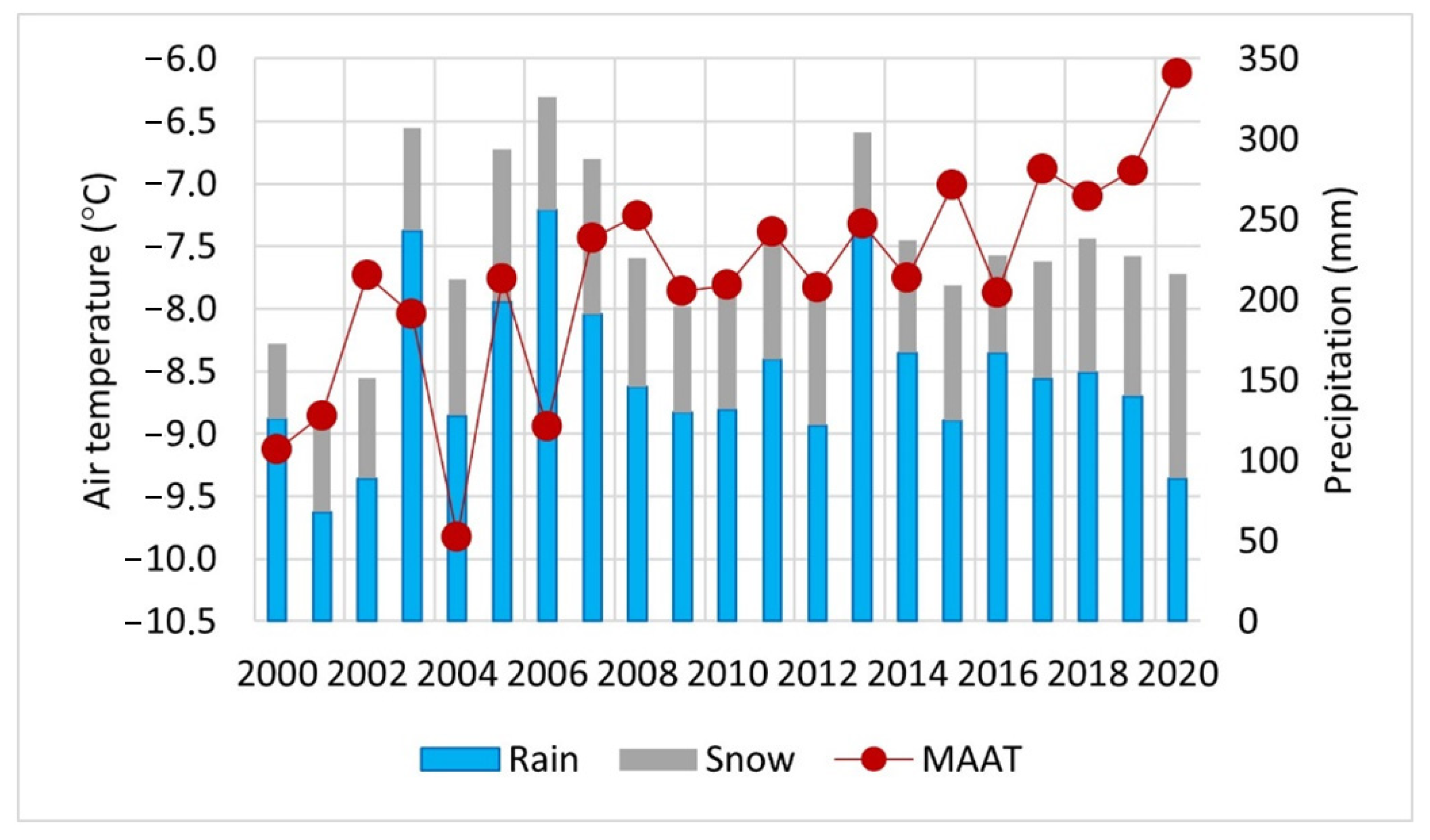
Air temperature. The mean annual air temperature (MAAT) in Yakutsk in 2000–2020 was −7.9 °C, higher than the mean long-term annual norm by 2.3 °C, which is −10.2 °C [
27]. From 2000 to 2006, the mean annual air temperature varied from −9.8 to −7.7 °C (
Figure 5). This period is relatively cold compared with the entire considered period (
www.meteo.ru/climate/sp_clim.php, accessed on 17 November 2021). The maximum forest fires in 2002 were associated with the maximum mean annual temperature during this period. The long period from 2007 to 2016 was characterized by relatively warm years with mean annual temperatures from −7 to −8 °C. Temperatures above −7 °C dominated in 2017–2020. Over the two decades under consideration, the mean annual air temperature increased by more than 2 °C.
Precipitation. The 2001–2002 forest fire was preceded by a relatively dry period (
www.meteo.ru/climate/sp_clim.php, accessed on 17 November 2021), with the smallest amount of precipitation compared with the preceding years of forest fires in Neleger and Central Yakutia (
Figure 5). Deviations of annual values from the mean long-term norm (234 mm) were −100 and −83 mm, respectively. During these years, forest fire activity in Central Yakutia was very high. This contrasts with the years 2005–2007, which were the wettest period in this series. The annual precipitation was more than the multiyear norm from 54 to 92 mm. The rest of the study period is characterized by precipitation close to normal, except for 2013, which was wet.
The amount of precipitation in all months of the hazardous forest fire season (May–September), except for September, in years with high forest fire activity is less than in years of low forest fire activity, and the difference during the season is from −4 mm in May to −18 mm in August (
Table 1). During periods of high forest fire activity, the air temperature is higher than during periods of “calm” for the three warm months. The most significant excess up to 2 °C was observed for June and July. In years with high forest fire activity in the summer months, there is a combination of a significant decrease in precipitation and an increase in air temperature compared to years with low forest fire activity.
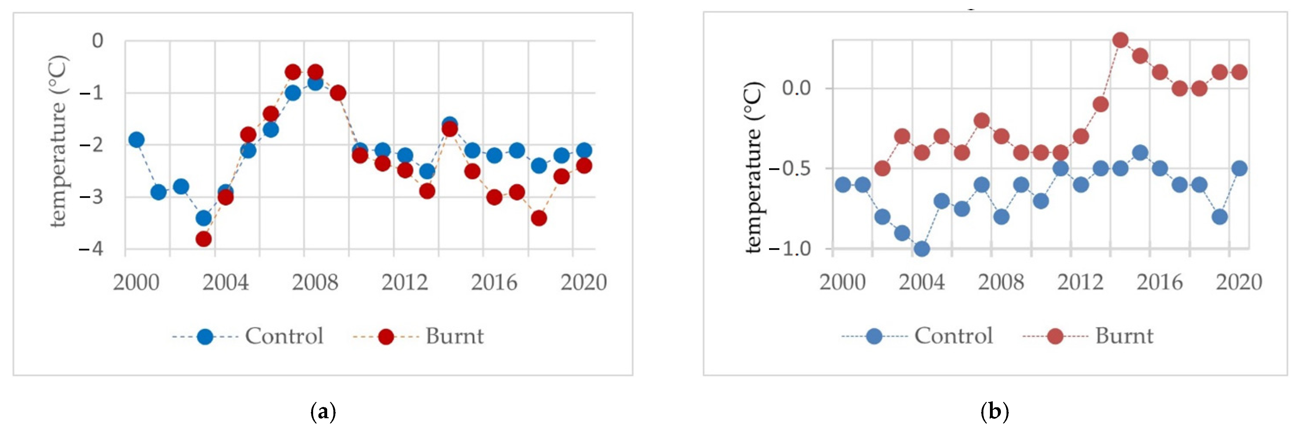
Ground temperature. The control group took mean annual ground temperature interannual variability at a depth of 1.6 m in the mature larch forest. After the forest fire in 2001, in the second–third years, the ground temperature was lower than the temperature in the control site (
Figure 6). The period of 2005–2008 coincided with the warming of permafrost in Central Yakutia, associated with a warming of the air and an increase in precipitation and a significant increase in snow cover [
28]. During this period, the mean annual ground temperature on a burnt site was 0.2–0.4 °C higher than in the mature larch forest. The sixth and seventh years turned out to be the years of the most significant influence of a forest fire on the ground temperature at a depth of 1.6 m when the ground temperature increased from −3.8 °C to −0.6 °C.
In 2009–2010, ground temperatures at these two sites were almost the same. From 2011 onwards, the temperature regime returned to its normal state for the control site. However, climate warming during this period meant that it did experience a complete return to its previous state. At this time, the maximum difference between the values of the temperatures of the two sites reached 0.8–1 °C. A relatively powerful cooling of the ground on a burnt site during an increase in air temperature is associated with an intensive growth of birch and larch undergrowth, which increases the shading of the surface in the summer. In addition, on a burnt site, this, combined with the remains of fallen tree trunks and shrubs, prevents the snow cover from adhering to the ground surface in winter. It cools the ground quite strongly, as does the effect of large littering of the ground layer with the remains of trees and bushes [
29]. However, the seasonal temperature contrast may be different; for example, in autumn, the temperatures are much warmer in the disturbed area than at the control site (
Figure 6b).
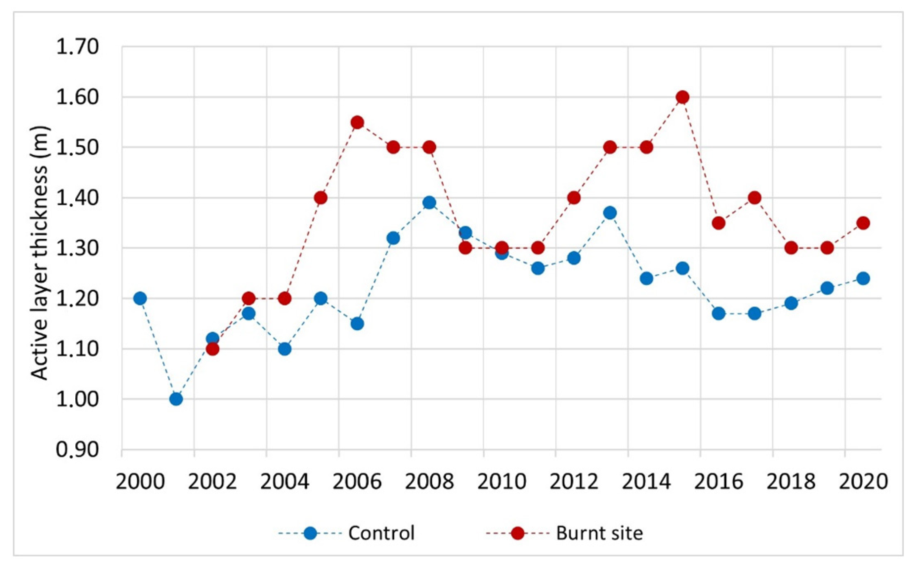
Active layer thickness. The mean long-term value of the active layer thickness in the control site was 1.22 m, and in the burnt site, this was 1.37 m. In the first two years after the forest fire, changes in the active layer thickness at the end of the summer in a burnt site are insignificant. From the third to the seventh years (2004–2008) after a forest fire, the difference between the values becomes observable. The maximum value of the active layer thickness during this period reaches 1.55 m (
Figure 7). Later in 2009–2011, the active layer thickness decreased in the burnt site. During these years, the ground temperature stabilizes at the control site. The second increase in the active layer thickness is associated with a secondary forest fire when the active layer thickness reaches 1.5–1.6 m. Compared with the first period of growth in the active layer thickness, this period was short-term, and since 2016, stabilization at levels 1.3–1.4 m was observed. Over time, in 2018–2020, during the 17th–19th years after the first forest fire, the difference between the active layer thickness in the burnt site and the control larch forest was only about 0.1 m.
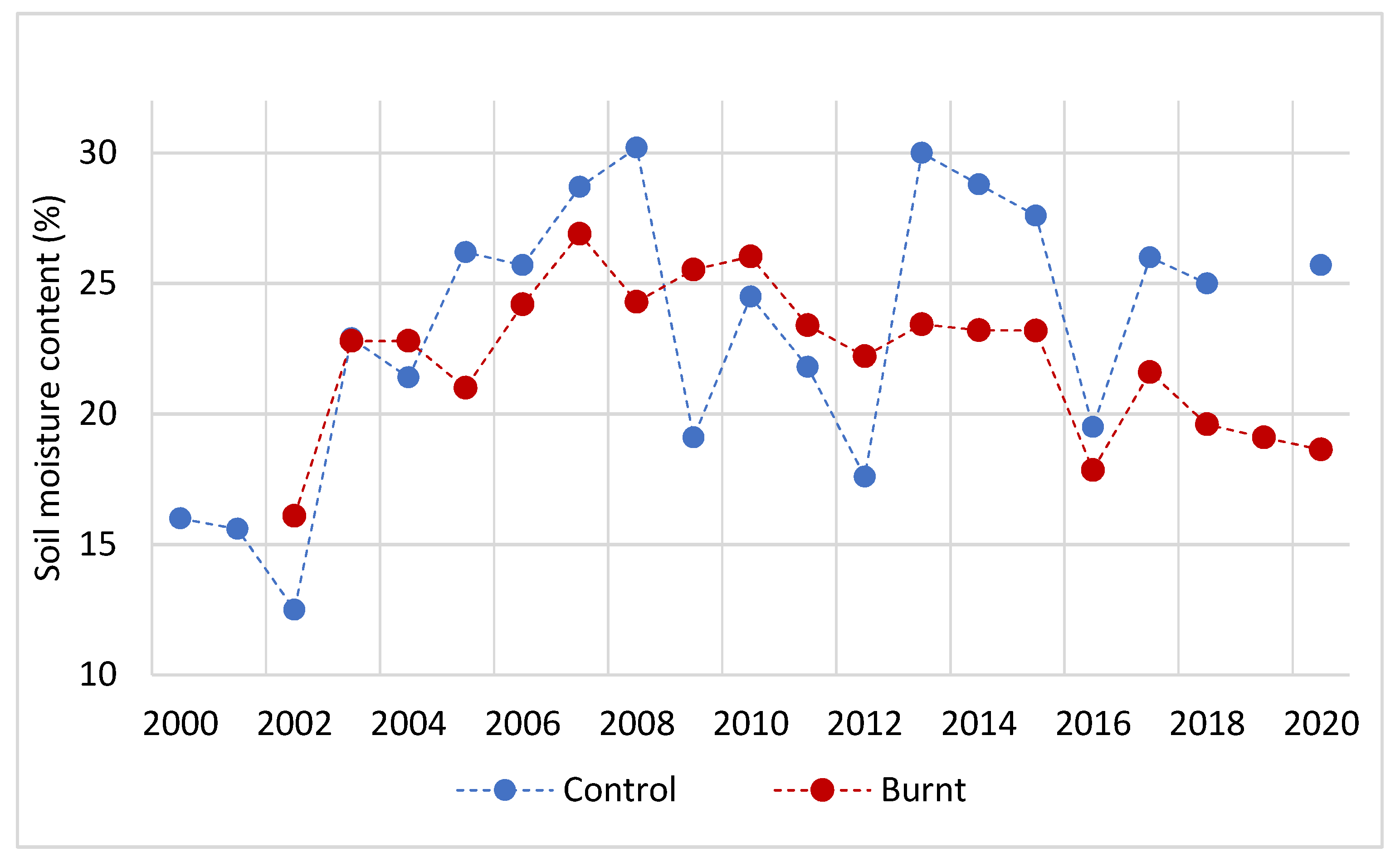
Soil moisture content. The mean long-term value of soil moisture in the control site for the period under consideration was 22.2%. In the first three summer seasons after the forest fire, the soil moisture content of the active layer in the burnt site increased significantly. From the fourth to the seventh years with large annual precipitation, in 2005–2007, the soil moisture content in the control site with the larch forest increased quite strongly, while in the burnt site with intensive developments of pioneer willow herbs, the moisture content turned out to be lower (
Figure 8). In the less humid years, 2009–2012, the burnt site was characterized by higher soil moisture than the control site. In general, after an initial short six-year period, with an increase in the soil moisture content of the active layer in the burnt site, a directed decrease was observed. Compared to the control site on a burnt site, the soil moisture content was on average 4.5–7% less. This period was associated with a decrease in the role of pioneer vegetation and replacement by herb–grass associations.
4. Discussion
Although high air temperatures and low rainfall contribute to increased forest fire activity, at the beginning of the study period when forest fire activity increased in Central Yakutia, the weather conditions were characterized by low rainfall but at relatively low air temperatures.
It is known that, in the first years after the disturbance, the ground temperature of permafrost landscapes increases. Tarabukina V.G. and Savvinov D.D. [
6], in the southeast of Yakutia, noted the direct effect of forest fires on the heating of soils due to a decrease in or complete disappearance of the heat-insulating impact of vegetation and ground cover. Thus, for example, at a depth of 1.2 m at the end of summer, the ground temperature on the burnt site was 1 °C higher than in the control undisturbed forest. Burn [
1] notes a 0.9 °C increase in ground temperature at a depth of 1.5 m in a spruce forest in the southern Yukon compared to an undisturbed site. Smith et al. [
2] carried out temperature monitoring after a forest fire in 1994 in the valley of the Mackenzie River in northwestern Canada. They noted that, at a depth of 1 m, mean annual temperatures increased by more than 3 °C during the first five years after the forest fire. These data are close to our results on the Neleger site. The mean annual ground temperature at a depth of 1.6 m in the burnt area increased by about 2.5 °C in the first 5–6 years compared to the control site in 2001. We recorded an increase in ground temperature in the first five years after clear-cutting in this site when the ground temperature in the control Larch forest site decreased in 2000–2004 [
30]. Therefore, the first stress after forest fires and clear-cutting is accompanied by an increase in ground temperature. Our results of changes in ground temperature at the initial stage of post-fire development are quite consistent with the general course of successions under such conditions [
2,
31].
In the first two years, the effect of a forest fire in our experiment did not significantly affect the active layer’s thickness (see
Figure 7). However, the increase in the active layer thickness from the third to the seventh years after the forest fire is significant, as many researchers have noted [
1,
2,
3,
32]. Usually, thermokarst or degradation of permafrost may develop at this time [
5,
33,
34]. Therefore, the development of forest cover in disturbed areas may significantly reduce the active layer’s thickness in the future [
3,
31,
35]. If we do not consider the effect of the secondary forest fire at the Neleger site in 2012, then, in recent years, the vegetation cover dynamics returned to the typical conditions for the development of successions, which is manifested in a decrease in active layer thickness.
The soil moisture content in the active layer was studied by Kirdyanov et al. [
3] in the permafrost region of Central Siberia. Using the succession assessment method, they established the basic patterns of soil moisture change at a depth of 5 cm from the surface. A reasonably significant decrease in soil moisture (from 45 to 30%) was noted up to about 10–15 years after the forest fires. After this reduction, there is a long recovery path of up to 180 years. According to our results at the Neleger site nine years after the forest fire, there is also a directional tendency towards a decrease in the soil moisture content of the active layer.
In general, the results of our studies are within the general tendency of successions in taiga landscapes. However, in connection with large-scale forest fires in Siberia in 2021 and the projected increase in the frequency and area of forest fires due to global warming [
11,
13], such studies should now be in demand. Furthermore, due to the predicted degradation of permafrost in Eastern Siberia [
36,
37,
38], the role of forests for its preservation becomes urgent.
Biotic factors in the development of permafrost landscapes are of great importance during the period of global warming. These include both evolutionary and successional development of vegetation. They have a relatively strong effect on permafrost temperature and the active layer thickness. In the last two to three decades in Eastern Siberia, thermokarst has been intensive in treeless areas, confirming the onset of permafrost degradation. In some areas of the Republic of Sakha (Yakutia) from the beginning of the 1990s to the present, according to our unpublished data, losses from the degradation of the ice complex ranged from 0.09 cubic meters per square meter in relatively weakly disturbed areas and up to 0.57 cubic meters per square meter in disturbed areas of high-ice landscapes.
5. Conclusions
The post-pyrogenic state of permafrost landscapes, studied over 20 years, generally took place during a period of constant increase in the mean annual air temperature and the conditions of a decrease in the amount of precipitation. The maximum warming of the ground was noted in the five to six years of burning in 2007–2008, when ground temperature increased from −3.8 °C to −0.6 °C. Subsequently, until 2020, the ground temperature at the burnt site was lower than in the control site in the larch forest for almost all years. Cooling of ground during the period of increasing air temperature is associated with the intensive growth of birch and larch undergrowth, which increases the shading of the surface in the summer. In addition, on a burnt site, this, combined with the remains of fallen tree trunks and shrubs, prevents the snow cover from adhering to the soil surface in winter. Therefore, this resulted in relatively strong cooling results of the ground, even despite the secondary forest fire in 2012.
In general, increases in ground temperature, the active layer thickness and soil moisture content on burnt sites after a forest fire in the Neleger area occur in the first six to seven years after a disturbance. After this, a change in the direction of development begins to stabilize permafrost conditions with the restoration of forest cover. This shows that the permafrost landscapes of Central Yakutia have a certain margin of safety and can be restored even in the most critical situations. The results of the studies will become the basis for planning restoration work after forest fires in permafrost landscapes of Central Yakutia.
Thus, with the current climate warming in Central Yakutia, treeless landscapes are in a critical state. Under these conditions, the role of forest ecosystems in preserving permafrost is important, and the conclusions of M.T. Jorgenson et al. [
39] that vegetation and soils are essential for the sustainability of permafrost are correct. The results of our studies can be used in planning environmental protection in areas disturbed by forest fires.


