Abstract
Coastal areas are exposed to high levels of human occupation, which has led to their degradation. Coastal dunes have been greatly altered by different historical and current land uses, causing the loss of their natural and cultural values. On the coast of Tenerife there are volcanic and organogenic sand active and relict dunes with multiple land uses, the most prominent of which is tourism (also the main cause of their deterioration). The aim of this study is to demonstrate the relevance of geomorphosites associated to the aeolian depositional systems of Tenerife as volcanic geoheritage through the application of international methodologies used for these evaluations, and to propose geotourism uses that will contribute to their sustainability. In Tenerife there are thirteen aeolian system geomorphosites in which palaeodunes, active dunes and a combination of both have been identified, 53.9% of which are protected. The main historical and current uses are related to grazing, sand mining and tourism. These different land uses have produced the degradation of these landforms, which have induced the loss of some of their scientific and additional values. The average score for the scientific values (0.58) is higher than for the additional values (0.41) in most of the thirteen selected geomorphosites; the values lie in the middle of the range and there is no correlation between the scientific and additional values (R2 = 0.17). The geotourism proposal presented in this study is associate to the volcanic diversity of the coast of Tenerife and should be aimed at both the general public and specialists. The number of visitors should be restricted and sustainable according to the zoning laws for the regulations and use of the protected areas; and it should use the net of authorized paths which already exists in the geomorphosites. To this end, certain facilities will be required to help disseminate and promote the heritage of Tenerife’s dune geomorphosites through panels, websites, apps or QR codes.
1. Introduction
Coastal areas have come under increasing human pressure [1], owing to the fact that they are home to 40–70% of the world’s population [2,3]. Aeolian depositional systems form a small part of the landforms found on young volcanic islands [4] yet they are a unique and important resource for assessing their geodiversity and geoheritage [5,6]. In addition to their limited extension, numerous impacts have brought about significant changes in the present landscape of these systems [7,8]. These impacts are related on the one hand to traditional uses such as logging and grazing [9,10,11,12] and, on the other hand, recent uses such as aggregate mining, vehicular traffic, urbanisation and recreational uses such as “sun-and-beach” massive tourism [13,14,15,16,17,18]. In general terms, human activity has caused a reduction in the area occupied by aeolian depositional systems [19], changes in landforms [19,20] and the remobilisation of sediments [21], among others.
The increased pressure that humans have exerted on sandy coastlines has focused coastal management on adapting them to the needs of users [22], especially tourists [22,23,24]. Environmental aspects have been relegated to the sidelines for the sake of financial gain [22,23]; however, since the 1990s, geomorphology has acquired increasing relevance in the management, protection, and conservation of the natural environment, having traditionally been overlooked in favour of biotic elements [25]. In order to alleviate the degradation of these areas, in many parts of the world restoration projects have been undertaken [26,27,28,29], conservation measures have been applied and, in some cases, management has been directly linked to controlled geotourism [30,31,32]. The task of geotourism is, among others, to create new tourist attractions and generate tourist traffic under sustainability criteria [33,34]. Aeolian depositional systems in the coastal regions of a subtropical volcanic island are ideal for geotourism as their reduced vegetation cover allows for better identification of landforms and natural and cultural heritage associated to the coastal dunes. For all these reasons, coastal dunes are very dynamic ecosystems, but they are also fragile spaces in relation to past and present land uses. In the case of the Canary Islands, aeolian sedimentary systems are highly affected by massive sun and beach tourism, especially in the eastern islands (Gran Canarias, Fuerteventura, Lanzarote and La Graciosa). For this reason, research is needed to value the diversity of their heritage and to contribute to its sustainable management through activities such as geotourism or volcano tourism.
Tenerife was chosen as the area of study because in the Canary Islands as a whole, the aeolian depositional systems are mostly concentrated in the eastern islands of Gran Canaria, Fuerteventura, Lanzarote and La Graciosa [35,36], while on the western islands—except for a very small number of isolated cases such as Playa Blanca on El Hierro, Playa del Inglés and Puntallana on La Gomera and Poris de Tigalate on La Palma—they are on the coast of Tenerife. It is here that we may find a significant number of active and relict aeolian depositional systems with highly variable dimensions and features [37,38], which are under severe human pressure, and which has led to their destruction, deterioration, and loss of their diversity [18]. For this reason, it is necessary to prevent the dunes from deteriorating further, thus, for this innovative use, management proposals must be made associated to responsible tourism and with the natural and cultural heritage present in the dunes, such as geotourism or volcano tourism.
The proposal of new products and tourist experiences in sun and beach destinations is not new and is related to the fact that they are in the mature or decline phases of the cycle of life of a touristic destination [39]. These are the results of both the obsolete nature of tourism services, equipment, and infrastructures, as well as changes in the profile of demand for more sustainable products. This has motivated the search for solutions to prevent the decline of traditional sun and beach tourist destinations through, among other aspects, the diversification of the offers in those destinations. In the case of Tenerife, the proposal of new tourist products and experiences such as geotourism is not something new [40]. For this reason, the aim of this study is to identify, select, characterise, and evaluate the geoheritage in the active and relict aeolian depositional systems of Tenerife and propose geotourism uses such as volcano tourism in them, taking into account their scientific and additional values and always guaranteeing their sustainability.
2. Study Area
Tenerife is a volcanic oceanic island that occupies a central position in the archipelago of the Canary Islands; it is also the largest (2034 km2) and the highest (3718 masl) of the islands. It is the emerged section of a large volcanic edifice that reaches a height of almost 7000 m from the sea floor (including the section that rises above the sea). One of the essential features of the island is the remarkable diversity of its volcanic landscapes [5]. This rich variety of terrains—containing a wealth of geological and morphological features—reflects factors such as monogenetic or polygenetic volcanism, the persistence of volcanic processes, and erosion and deposition processes. Tenerife can be divided into at least six different morphostructural areas (Figure 1) made up of three old shield volcanoes (Teno, Anaga and Roque del Conde) where erosion landforms—such as ravines and cliffs—predominate, two volcanic rifts (Pedro Gil and Abeque) the Bandas del Sur formation with well-preserved volcanic landforms including hundreds of cinder cones and lava fields and, finally, a complex central sector made up of the overlapping edifices of Las Cañadas and the stratovolcanoes of Teide-Pico Viejo and their volcanic domes [41] (Figure 1).
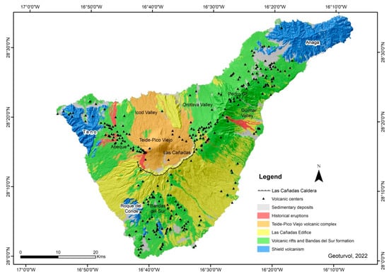
Figure 1.
Geological simplified map of Tenerife. Source: IDE-Canarias-Grafcan. Self-elaboration.
Therefore, on the island we find both landforms directly related to volcanism (stratovolcanoes, domes, cinder cones, hornitos, ʻaʻā, pāhoehoe, block lava flows, etc.), and landforms that originate from the processes of erosion and deposition (ravines, cliffs, beaches, etc.). The latter include aeolian depositional systems, which in Tenerife can be grouped into three types: palaeoforms, active aeolian landforms or a combination of both. The origin of the aeolian sediments is usually a combination of volcanic terrigenous and organogenic sands [37] and the proportions vary widely; the Jover, Milán and Bajamar coastal dunes have the highest proportion of carbonates [42].
The climate in the aeolian depositional systems is characterised by aridity, with an annual average rainfall of less than 100 mm, an annual average temperature of around 21º C and dominant NE–SW winds [43]. These weather conditions determine the vegetation cover. In active dunes, the vegetation is shrubby with poor cover and is adapted to the conditions of salinity and sediment mobility. In the palaeodunes, vegetation is very scarce due to both the compaction of the sands and, in certain cases, the verticality of the deposits.
3. Methodology
The methodology used to identify, characterise, and evaluate the geomorphosites associated to the aeolian depositional systems of Tenerife was based on previous research conducted on both volcanic and non-volcanic sites [13,44,45,46,47,48,49,50,51,52,53]. We applied this methodology and not similar methodologies because the proposed method for identification, characterisation and evaluation proposed by Reynard et al., 2007 and 2016, is more according to the geographical approaches concept of the geotourism that we implemented in this study for the assessment and management of the aeolian sedimentary deposits.
The bibliographical revision [35,36,37,38], aerial photographs, maps at different scales (topographic, geological, geomorphological, vegetation and human uses), DEMs, and fieldwork during several campaigns in the years 2020–2021 were used in the study of the geomorphosites associated to the island’s aeolian systems. This methodology was to collect data, for the analyses of data, for fieldworks and to obtain the main results concerning the aeolian geomorphosites in Tenerife, as well as to propose the assessment and uses (geoconservation/geotourism) of their coastal dunes (Figure 2).
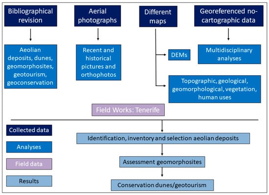
Figure 2.
General methodology applied in this study.
Drawing on these methodologies for assessing the geoheritage of geosites or geomorphosites applied in other places, this study was developed in three phases [13,44,46,47,48,49,50,51,52,53]: (1) the distribution, identification, inventory and selection of aeolian geomorphosites; (2) the characterisation of the selected sites; and (3) the evaluation of the sites taking into account their intrinsic values (scientific and additional) and their use and management values, according to several previous studies [44,46,47,48,49,51,52].
3.1. Distibution, Identification, Selection and Inventory of Geomorphosites
This step was associated with the collection of data from previous investigations, different maps, photos, fieldworks and other information related to geomorphosites. The inventory took into account whether they were palaeoforms, active aeolian landforms or a combination of both. In the final selection, consideration was given to the spatial distribution of the aeolian depositional geomorphosites, whether they were representative of this type of landform, whether they were accessible and whether they were well preserved, although this last criterion was not met by all geomorphosites due to the strong human pressure to which they are subjected, among others, by massive tourism.
3.2. Characterisation of Geomorphosites
Documents studied in this phase correspond to the analyses and fieldwork steps. The documentation for characterisation of the aeolian dunes included general numerical data (coordinates, elevation, etc.) that were used to locate the geomorphosites on a synthesis map (Figure 3), and qualitative information on their characterisation (geology, geomorphology, geography, ecology, history, aesthetics, tourism, archaeology, facilities, infrastructures, etc.). Qualitative documentation is essential for the evaluation of the intrinsic values (scientific and additional) and the use and management values of each of the geomorphosites [44,46,47]. Both types of data were collected in a fieldwork data sheet that facilitated the processing of the information.
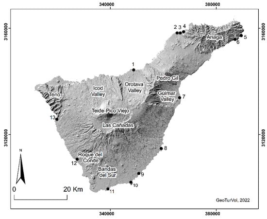
Figure 3.
Aeolian sedimentary systems of this study. 1. Puerto de La Cruz; 2. Jover; 3. Milán; 4. Bajamar; 5. Antequera; 6. Igueste de San Andrés; 7. Malpaís de Güímar; 8. Punta de Abona; 9. Montaña Pelada; 10. El Médano-Montaña Roja; 11. Montaña Amarilla; 12. La Caleta; 13. Los Gigantes. Source: self-elaboration based on the DEM of IDE-Canarias-Grafcan.
3.3. Evaluation of Geomorphosites
The methodology applied to the evaluation of the geomorphosites was the one proposed by Reynard et al. [44,46]. It takes into account the intrinsic values that are considered inherent and specific to each geomorphosite—to which a quantitative evaluation is applied—while the use and management values are not considered a value of the geomorphosite, hence a qualitative evaluation is applied [46]. However, there are authors who apply a quantitative evaluation to use and management values [52,53] as it minimises the effects of subjectivity [54], consequently, qualitative evaluation has also been shown to be very useful for geomorphosite management [46].
According to Reynard et al., 2007 and 2016, the intrinsic values were divided into scientific and added values. The former were further subdivided into four types: integrity, representativeness, rareness and palaeogeographical interest. The integrity represents the state of conservation of the site. Bad conservation may be due to natural factors, e.g., erosion, or human factors, e.g., massive tourism [44,46]. The representativeness is related to the site’s intrinsic value and is used with respect to a reference space (e.g., region, commune, island, country). All the selected sites should cover the main processes, active or relict, in the study area [44,46]. Rareness concerns the rarity of the site with respect to a reference space (e.g., region, commune, island, country). This criterion serves to identify exceptional landforms in an area [44,46] such as fossil dunes. Finally, palaeogeographical interest shows the importance of the site for Earth or climate history [44,46] (e.g., the evolution of changing marine levels through coastal active or inactive dunes).
Added values were also grouped into four types: ecological (ecological influence and protected site), aesthetic (viewpoints and contrasts, vertical development and space structuration), cultural (religious and symbolic importance, historical importance, artistic and literature importance, and geohistorical importance), and economic value (economic products) [44,46].
Use and management characteristics correspond to protection and promotion [44,46]. The former was further subdivided into two types: protection status (refers to the level of protection of the site relative to its link to different natural protected areas) and damages and threats (level of damage of the site by human activities or natural processes and, as for threats, one must report if they are based on a real and feasible projection in the short/medium term) [49,51]. Promotion encompasses the visit conditions (accessibility, security, site context and tourism infrastructures) and education (interpretative facilities and education interest and levels) [49,51].
The numerical scale (Table 1) for scoring each item ranges from a minimum of zero to a maximum of one point, in intervals of 0.25. In order to be able to establish comparisons and define a hierarchical level for each geomorphosite, the data are expressed in average values and the following classification was established: low if the scores are <0.4; medium if they are ≥0.4 and <0.6; and high if they are ≥0.6 [47,50]. In this study, in keeping with [44,46,47], the quantitative evaluation was performed only for intrinsic values.

Table 1.
Criteria used for the assessment of the scientific value and additional values. Adapted from Reynard et al., 2007; 2016 [44,46] and Bouzekraoui et al., 2017 [47].
4. Results and Discussion
4.1. Distribution, Inventory and Characterisation of Aeolian Depositional Geomorphosites
A total of thirteen geomorphosites associated with the aeolian depositional systems have been identified and inventoried on the coast of Tenerife. They are the result of the accumulation of sand on lava flows, volcanic edifices and depositional areas. The island’s dunes are either palaeoforms (Puerto de La Cruz, Jover, Milán, Bajamar, Igueste de San Andrés, Montaña Amarilla, La Caleta and Los Gigantes), active aeolian landforms (El Socorro-Malpaís de Güímar and Punta de Abona-Abades) or a combination of both (Antequera, Montaña Pelada and El Médano-Montaña Roja) (Figure 3). The first are landforms associated with marine regression periods in where the surface over which the wind could blow would have been greater than at present; these landforms currently bear evidence of marine erosion processes [42]. The second are the result of the erosion of nearby ravines that provide a source of nourishment for the beaches that give rise to the dune systems. In the third group, a combination of both processes is evident, and it can be observed that the erosion of the palaeodunes also acts as a source of sediment for the active aeolian landforms, as is the case in Antequera, Montaña Pelada and El Médano-Montaña Roja. In turn, the different dunes present a large number and variety of types of aeolian landforms. Table 2 shows the relative importance of the dunes in each geomorphosite selected, divided into if they are present, frequent or abundant. All the selected geomorphosites are accessible and represent the full diversity of aeolian depositional landforms and processes on the island of Tenerife.
Table 2.
The relative importance of aeolian landforms in the study area and their protection. P: present landform, F: frequent landform, A: abundant land form. The grey colour shows the presence of the item. Self-elaboration from fieldwork.
The aeolian palaeoforms present an erratic distribution on the island and have a limited extension, except in specific cases such as Montaña Amarilla or El Médano. Palaeodunes are found interstratified between lava flows at an altitude of more than 30 m on cliffs eroded by the sea (Figure 4A,B) or abutting the hydromagmatic deposits of the Montaña Amarilla tuff ring (Figure 4G). The morphologies are steeply dipping and stratified, demonstrating their aeolian origin (Figure 4C,G); however, in many cases identification is complex due to the fact that most of them have undergone marine (Figure 4D–F) and torrential erosion processes, or because they have been built upon (Figure 4E). Notable among these landforms are rhizolithes (Figure 4H) and palaeoliquefaction structures (Figure 4I) [55].

Figure 4.
Palaeodunes of Tenerife. (A): Puerto de la Cruz; (B): Jóver; (C): Milán; (D): Antequera; (E): Igueste de San Andrés; (F): El Médano; (G): Montaña Amarilla; (H): rhizolithes in Antequera; (I): palaeoliquefaction structures in El Médano-Montaña Roja. Source: authors.
In the case of active landforms where the slope allows them to expand, we find nebkhas fields and shadow dunes associated with shrub vegetation (Figure 5A,B). The best examples of this type of system are El Médano-Montaña Roja, La Punta de Abona and Montaña Pelada. In addition, there are other morphologies such as climbing dunes on the backshore of beaches with cliffs with a gradient of between 30% and 45%; moreover, in these cases the sand rises above the cliff and forms nebkhas and shadow dunes on top when the scarp face is no higher than eight metres, as in the case of La Punta de Abona. However, when the slope of the coastal escarpment exceeds 45%, the sand only forms climbing dunes and does not rise above the cliff, as occurs in El Médano or Antequera (Figure 5D). In the areas of sand outflow in the aeolian depositional systems of La Punta de Abades there are two falling dunes which are now isolated from their sediment source due to intense historical human pressure (crops, buildings, and car parks). As for echo dunes, there is no specific pattern to their spatial progression, but rather they occur where there are obstacles; their occurrence is sporadic, except in Montaña Pelada and Punta de Abona, where human construction and the relief make these dunes a frequent landform. Finally, it is worth mentioning the presence of mobile sands, which do not form nebkha fields due to an insufficient volume and the roughness of the terrain, as at Malpaís de Güímar (Figure 5C).
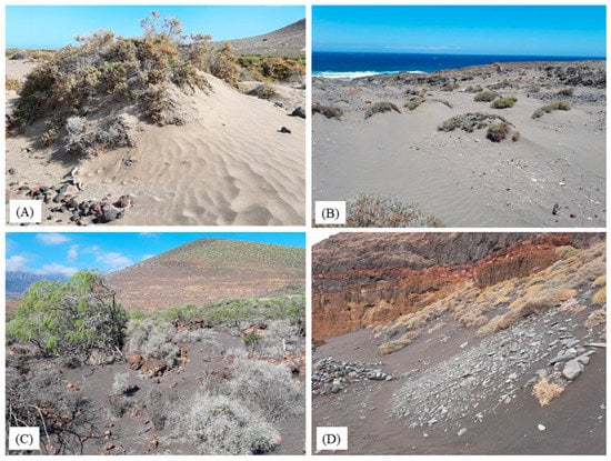
Figure 5.
Different examples of active aeolian geoforms in Tenerife. (A): nebkha with ripples (El Médano); (B): nebkhas with shadow dunes (Montaña Pelada); (C): sand sheets (Malpaís de Güímar); (D): climbing dunes (Antequera). Source: authors.
Active aeolian landforms and palaeoforms are combined at numerous locations. In Antequera, the remains of a palaeo-climbing dune can still be seen today, highly eroded by the sea, with little lateral continuity and less than a metre thick. It must have had morphological and dynamic characteristics similar to those of the present-day climbing dune that overlies it, and which reaches a height of 10 m, conditioned greatly by the verticality of the cliff composed of lapilli and lava. In the case of the Montaña Pelada tuff ring a similar situation occurs: a small palaeo-climbing dune that barely reaches 4 metres in height and is severely deteriorated by marine erosion and tourism use; in addition, on the SSE flank there is an active climbing dune that is channelled through a small ravine and reaches heights of over 50 m [56]. However, the most significant case is undoubtedly that of El Médano, where we find cemented layers of sand on which today there are nebkhas and shadow dunes that are fed by erosion and the largest palaeo-climbing dune in Tenerife, reaching heights of more than 60 m and an uninterrupted longitudinal extension of more than 300 m. This palaeodune is located in the horseshoe crater and the west flank of the Montaña Roja cinder cone and although at present a small climbing dune can be seen at the western base of the volcano, the presence of the palaeodune that formed during a period of lower sea levels suggests changes in the environmental conditions of this area since, unlike Antequera, it does not presently feature any active equivalent landform.
4.2. Land Uses and the Cultural Landscape
Dune systems have been heavily exploited by human activity throughout history, both internationally [9,10,15] and in the case of the Canary Islands [12,18,57,58]. As such, they have given rise to an important cultural legacy that is reflected both in the tangible heritage found in their immediate vicinity [57,58] and in the cultural landscape that reflects the land-use legacy [18,57]. A large part of the tangible heritage of significant cultural value is concentrated in the active landforms due to their greater spatial extension compared to the palaeodunes, the fact that they are located in the few flat areas of the island, and the historically strategic enclaves in which they are located, as in the case of El Médano-Montaña Roja.
The aeolian sedimentary systems were only exploited as seasonal grazing grounds until the arrival of the lime kiln industry. From that time onwards, local vegetation began to be exploited and quarries were built to obtain stone. In the case of El Médano, there are numerous references to its importance as a port owing to its mooring capacity and the visit of illustrious travellers such as Ferdinand Magellan (1–2 October 1519); however, the greatest transformation of this system came in the 20th century with the boom in aggregate mining, which produced major quarries and the Tomás Zerolo aerodrome (opened in August 1935 and closed in 1975). As for Antequera, it was only used as a loading dock for agricultural products. For this reason, some storage buildings still stand next to the wharf, now abandoned and partially buried by the sand (Figure 6E).
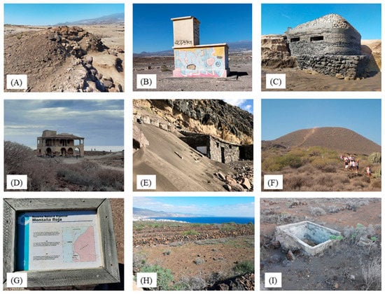
Figure 6.
(A): lime kiln; (B): control tower of the ancient airfield; (C): World War II bunker; (D): sanatorium; (E): former agricultural warehouses; (F): religious festivity or pilgrimage of El Socorro; (G): panel about cultural heritage; (H): abandoned crops; (I): water pond. Location: (A–C,G), en El Médano; (D), en Punta de Abona; (E), en Antequera; (F,H,I), Malpaís de Güimar. Source: authors.
With regard to the presence of elements related to historical land use, we find lime kilns (Figure 6A), the remains of the control tower of the old aerodrome in El Médano (Figure 6B), a considerable number of bunkers and pillboxes from the Second World War (Figure 6C), the presence of several wharves for the import and export of agricultural products and limestone in El Médano and Antequera, and the lighthouse and sanatorium in Punta de Abona (Figure 6D). In Malpaís de Güímar, the pilgrimage of El Socorro (Figure 6F) and the large number of elements associated with tomato cultivation in the area until the end of the 1960s (Figure 6H,I), stand out for their cultural significance associated with archaeological remains. By contrast, the palaeoforms exhibit less cultural heritage because they are structures that were only used as quarries for the extraction of aggregates in the cases of Bajamar, Jover and Milán.
While it is true that aeolian systems can be degraded by natural erosion—as can be seen in most palaeodunes—it is the historical and current human activity that has caused the most significant impacts. It has been found that the passage of a single vehicle or a few people over the dunes is sufficient to cause significant damage to the dune and its vegetation [15,58] (Figure 7G). The main impacts on aeolian depositional systems in the Canary Islands are related to a reduction in sediment volume due to extraction [18], the creation of aeolian shadows [17], parts of the aeolian system occupied by urbanization [16] and the appearance of barriers to sediment transport [20] that have degraded and transformed the aeolian landforms. These impacts are a consequence of current mismanagement [59,60] but also of historical management practices [18]. Of particular relevance is the effect of aggregate mining for the construction industry on the palaeodunes of Jover and Milán (Figure 7A) and on the present-day El Médano system; the construction of terraces for agriculture (Figure 7B); walls to stop the transport of sand (Figure 7C); partial urbanisation of the aeolian systems, landscaping, and graffiti on the palaeodunes of Montaña Amarilla and Montaña Pelada (Figure 7D–G); and recreational practices such as hiking and cycling (Figure 7H), gay cruising [61], and religious pilgrimages (Figure 7I) in the case of El Médano-Montaña Roja [62].
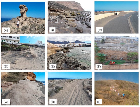
Figure 7.
(A): Quarries in Milán; (B): farming in Igueste de San Andrés; (C): roads and walls in Montaña Pelada tuff ring; (D): local buildings in Punta de Abona; (E): tourism in la Caleta; (F): gardens in Los Gigantes. (G): graffiti in the palaeodune in Montaña Amarilla tuff ring. (H): paths in El Médano-Montaña Roja. (I): pilgrimage in Malpaís de Güímar. Source: authors.
4.3. Quantitative Assessment of the Intrinsic Value of Geomorphosites
Table 3 shows the scientific and additional values for the thirteen selected geomorphosites in the aeolian depositional systems of Tenerife. The highest scores are given for El Médano-Montaña Roja with 0.94 for scientific and 0.72 for additional values, while the lowest scores for both types of values are given for the Puerto de La Cruz relict dune with scores of 0.25 and 0.22 for scientific and additional values, respectively. This is not surprising given the variety of landforms and processes present in El Médano-Montaña Roja, which has been declared a special nature reserve [63]; however, in Puerto de la Cruz, the dune interstratified between the ʻaʻā lava flows of the Martíánez cliff has shrunk, mainly as a result of urban development over the course of the recent history of tourism, which has led to its degradation and partial destruction.
Table 3.
Scientific and additional values of aeolian sedimentary systems detected in Tenerife.
Overall, the average scientific values (0.58) were higher than the average additional values (0.41); they are values obtained from the scale proposed by Bouzekraoui et al. [47] and Dóniz-Páez and Becerra-Ramírez [50]. Similarly, the average score for the scientific values for the selected sites was always higher than it was for the additional values, except where the aeolian systems occupy a small area of no more than several metres, as in Igueste de San Andrés or La Caleta, or when they correspond to only one or two types of aeolian landform, as in El Socorro-Malpaís de Güímar. When grouping the intrinsic values of the geomorphosites into high, medium and low values, it can be seen that for the scientific values 53.8% were high, 30.7% medium and 15.5% low; while for the added values 23.2% were high, 30.7% medium and 46.1% low. Therefore, the resulting indices seem to be in perfect agreement with the designation of 53.9% of the geomorphosites as protected natural areas under Canary Island legislation, where natural abiotic features prevail over cultural aspects in the configuration of the landscape; however, the relict dunes of Jover and Milán deserve special mention. Although they are not protected natural areas and are still affected by sand quarries, they are highly valued scientifically due to the rarity and palaeogeographic interest of their relict dunes [42].
As regards the relative position of the geomorphosites in terms of average intrinsic values, El Médano-Montaña Roja occupies the first place in both ratings. This has to do with the fact that this special nature reserve is home to the most important and largest area of aeolian depositional systems in Tenerife [18] and contains practically all aeolian landforms identified on Tenerife. It also boasts additional cultural values associated with the presence of archaeological remains, abandoned crops, the port, World War II bunkers and pillboxes, the old station of the telegraph line that ran to Senegal, the first aerodrome in the south of Tenerife and the first circumnavigation of the world by Magellan. It is striking, however, that places with high scientific scores were not similarly positioned in the ranking of additional values (Jover and Milan). This seems to be due to the fact that, although they are places with very high values of rarity and palaeogeographic interest, they do not have significant additional values because they do not currently attract much attention, they are not protected, and their most important cultural heritage is associated with the extraction of sand, which has caused their deterioration. In turn, there are geomorphosites (Socorro-Malpaís de Güímar and Los Gigantes) with high additional values and medium scientific values. These values were determined by the limited representativeness and palaeogeographic interest of the aeolian systems present at both sites.
When correlating the scientific with additional values (Figure 8), the geomorphosites are widely dispersed and it is difficult to establish groupings. In fact, the value of the linear correlation coefficient (R2 = 0.17) is very low, and it is safe to say that there is no linear relationship between the scientific values and the additional values. Even so, if the score for scientific values is used, the geomorphosites could be grouped into three main groups.
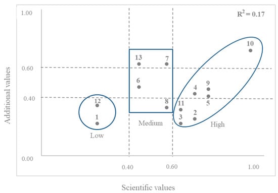
Figure 8.
Correlation between scientific and additional values of sedimentary aeolian systems from Tenerife volcanic island.
- Low: geomorphosites with low scientific values, which in turn correspond to those with low added values because they are palaeodunes that are severely deteriorated by tourist developments (Puerto de la Cruz) or because they have a small surface area of only a few square metres (La Caleta).
- Medium: aeolian depositional systems with medium scientific values and added values with low (Abades), medium (Igueste de San Andrés) and high (Socorro-Malpaís de Güímar and Los Gigantes) scores.
- High: geomorphosites with high scientific values and additional scores in all three intervals. Of this last group, El Médano-Montaña Roja is the only geomorphosite with high scores for both scientific and additional values, which is, as mentioned above, a consequence of its rich and varied natural and cultural heritage associated with the diversity of the volcanic process and forms and important land uses.
With regard to the use and management values, certain observations need to be made, especially when these values refer to aspects such as the protection and promotion of the site, which are of paramount importance for geotourism in the selected geomorphosites. With respect to protection, 53.9% of the geomorphosites form part of the Canary Islands network of protected natural areas, which include nature reserves (Malpaís de Güímar and El Médano-Montaña Roja), natural monuments (Montaña Pelada and Montaña Amarilla) and rural parks (Antequera, Igueste de San Andrés and Los Gigantes). In addition, almost all of them are included in the Natura 2000 Network as special conservation areas (SCA) and special protection areas (SPA) or belong to the Anaga Biosphere Reserve (Antequera and Igueste de San Andrés).
The main current threats to the aeolian depositional systems of Tenerife are, as mentioned above, related to the influx of visitors associated mainly to the tourism and related facilities and infrastructures. Although it is true that in the seven geomorphosites that are protected, public use is governed by the conservation rules of each of the natural protected areas, the ongoing degradation of the aeolian depositional systems, whether they are protected or not, raises questions about the need to reduce the influx of visitors and the type of activities that can be carried out on them. This type of measure would reduce tourism pressure in several of the geomorphosites studied, such as El Médano-Montaña Roja, Montaña Pelada, Montaña Amarilla, Antequera and Punta de Abona-Abades.
As for the use and management values of the geomorphosites studied in terms of promotion (visits and education), the differences between them are significant. El Médano-Montaña Roja and Malpaís de Güímar feature several interpretation panels explaining the natural and cultural heritage of these geomorphosites, which are visited by a large number of visitors. Meanwhile, other popular sites such as Los Gigantes, Punta de Abona-Abades, Montaña Pelada and Montaña Amarilla do not have this type of information tool to raise awareness of the natural and cultural heritage of these aeolian depositional systems.
5. General Discussion
It is clear that the main cause of the degradation of Tenerife’s aeolian depositional systems in the past and currently is the human activity. Grazing, sand mining, construction and mass tourism are the main causes of their deterioration and, in some cases, their disappearance, as in the case of Las Américas. Even so, these areas, which have some highly interesting intrinsic and additional values, deserve to be known by the local population and by visitors. This rich and varied natural and cultural heritage of active and relict dunes associated with the volcanic landforms and processes and human uses, should form part of the range of attractions on offer for geotourism or volcano tourism in Tenerife [64]. As Dowling [65] pointed out, “understanding the identity or character of a region or territory—which is unquestionably represented by the geoheritage of the geomorphosites—is essential for the development of geotourism.
Geotourism is a relatively recent form of tourism [66] that has been consolidated with the creation of the European and Global Geopark Networks. Among the activities it encompasses, different types may be classified depending on whether the approach to geotourism is related to the geological or the geographical, and in no case are they mutually exclusive [67]. The former relates to a type or form of tourism focused on visiting certain geological and geomorphological resources where the sites have high aesthetic values [65,66,67,68,69]. By contrast, the geographical approach takes a holistic, comprehensive view and also takes into account the other components of natural heritage such as biodiversity and everything related to the tangible and intangible cultural heritage of the landscape of the selected sites [70,71,72,73,74,75,76,77,78,79,80,81].
With this in mind, the geotourism activities carried out in this study for the aeolian depositional systems of Tenerife are linked to the geographical approach, in which the natural abiotic, biotic and cultural heritage of the thirteen geomorphosites play a prominent role. This is amply reflected in the scientific and additional assessment of the methodology used in this study [44,46], where in addition to the integrity, rareness, representativeness or palaeogeographic interest, the ecological, aesthetic, cultural, economic, use and management values of each of the geomorphosites were taken into account. However, since it has been pointed out that one of the different uses that is causing the deterioration of Tenerife’s aeolian depositional systems is mass tourism, our proposal should seek a less aggressive, less intensive tourism approach that is more committed to the sustainability of the heritage found in these thirteen geomorphosites. Therefore, the type of user to whom this proposal is addressed can be varied and may encompass different types: tourists (including enthusiasts and guides), scientists, and investors (owners and managers) [33,34]. In this regard, the different activities carried out by geotourists in geomorphosites, regardless of whether they are protected or not, should be guided by the utmost respect for the totality of the attractions that they offer. They must also distance themselves from the budgets of mass tourism, which is chiefly to blame for the degradation of Tenerife’s dunes and which continues to flourish within the geomorphosites, even though they are protected, as is the case with Montaña Amarilla, El Médano-Montaña Roja, Montaña Pelada and El Malpaís de Güímar. Therefore, in those geomorphosites which are protected or included in protected areas, geotourism must be guided by the zoning of uses (restricted, moderate, and general) that are included in their conservation plans and regulations, so that recreational use in the aeolian depositional systems of Tenerife is compatible with the conservation of their heritage.
With the aim to show the rich natural and cultural heritage of Tenerife’s active and relict aeolian depositional systems, our geotourism proposal is based on targeting both a general and a specialist public, and on the wide range of activities offered by each of the geomorphosites (sun and beach, water sports, volcano tourism, hiking, landscape, starlight, relaxation, birdwatching, culture or food and drink). In order to classify the diverse attractions on which geotourism activities should be based in keeping with the volcanic nature of the island, an inventory was drawn up of the types of volcanic resources that may be identified in each of the selected geomorphosites, based on the proposals of Sigurdsson and Lopes [82] and Dóniz-Páez [83] for volcano tourism. Of the eight types of resources and/or attractions described for volcano tourism, almost all can be found in the aeolian depositional systems of Tenerife, except for eruptions and thermal activity (Table 4). Those that can be found in the thirteen geomorphosites are landscapes, followed by beaches, sports, ecotourism activities, archaeology, and cultural heritage, while the least represented is the link between volcanoes and religion. The geomorphosite with the greatest number of attractions is El Médano-Montaña Roja, and the sites with the fewest are Jover and Milán. This ties with the characterisation of the natural and cultural heritage and the scores for scientific and additional values obtained in each geomorphosites.
Table 4.
Attractions for volcano tourism: 1. landscapes; 2. eruptions; 3. hot springs; 4. ecotourism; 5. sports; 6. beaches; 7. archaeology–cultural heritage; 8. religion. Self-elaboration based on Sigurdsson and Lopes [82] and Dóniz-Páez [83].
In order to propose geotourism activities associated with volcano tourism on the dunes of Tenerife, it would be necessary to provide facilities such as information panels, guidebooks, QR codes, apps, websites, etc., to promote and disseminate the values of these aeolian depositional systems on the island, and to make users aware of these values to prevent their further degradation. In the same vein, it is necessary to improve the most used paths and eliminate the low-use paths that generate a much greater spatial impact than the most used paths [84], thus facilitating and organising mobility on the paths and reducing the impact of visitors as much as possible. It would even be advisable and beneficial if all the aeolian depositional systems of the island could be grouped around one or several routes, similar to those described elsewhere [6,31], or grouped together in a geotourism guide similar to those that already exist for Tenerife [40,64].
6. Final Remarks and Recommendations
Tenerife is a medium-sized oceanic island of volcanic origin and receives more than five million tourists a year, attracted by the sunshine, beaches and landscapes, which makes it a well-established international tourist destination. The island’s coastline is densely occupied by tourist and non-tourist urban development [85] and is subjected to intense human pressure, which has led to the disappearance of part of its natural and cultural values. The aeolian depositional systems located in the Tenerife coastline are few, occupy a small area and have been used for various purposes (grazing, agriculture, sand mining, fuel, ports, airfield, bunkers and pillboxes, construction, massive tourism, etc.), which have led to the loss of their intrinsic values, a reduction in their surface area and, in some cases, their disappearance. For this reason, this study provides an inventory and assessment of the geoheritage of the island’s aeolian depositional systems and proposes a change in their use that is geared towards a type of tourism and a type of visitor that is more committed to the sustainability of these spaces.
Thirteen aeolian depositional systems have been identified, inventoried, characterised and evaluated in Tenerife, 53.9% of which lie within a protected natural area recognised by the laws of the Canary Islands. The dunes are mainly distributed along the coastline of the southern slopes of the island and are grouped into three main types: palaeodunes, active dunes, and a combination of both. In general terms, the dunes of Tenerife have higher scientific than additional values, and the intrinsic values as a whole fall into the medium range. Of all of these systems, El Médano-Montaña Roja has the greatest diversity of aeolian landforms, as well as the most varied cultural heritage of all the dune systems on Tenerife.
The coastline where the dunes of Tenerife are located is ideal for the practice of geotourism, due to the natural dynamics of the area: a diversity of volcanic geoheritage, arid environmental conditions, with little vegetation cover and the vestiges of a fascinating cultural heritage. Therefore, the geotourism proposal for these areas is in tune with a geographical approach to geotourism and with the diverse range of attractions possible for volcano tourism. Ideally, all the coastal dunes of Tenerife could be grouped together in a geotourism guide or around one or more volcano tourism itineraries in which their geographical heritage would be highlighted.
Although there are clearly many different methodologies for evaluating the geoheritage of geosites and geomorphosites, the methodology proposed by Reynard [44,46] is particularly well suited to the geographical approach to geotourism [67]. It highlights the geological and geomorphological aspects of the sites studied, but also the ecological, aesthetic, economic and cultural values associated with the tangible and intangible heritage that are present in these areas and that undoubtedly contribute to enhancing their potential for geotourism. To this effect, future recommendations regarding geotourism in active and relict aeolian depositional systems run along two lines. They include, on the one hand, more detailed research at different scales combined with other types of factors that affect the coastline and, on the other hand, improving the methodologies for assessing the geoheritage according to the principles of geotourism proposed by National Geographic [75,76].
Author Contributions
Conceptualization, J.D.-P. and N.M.-R.; methodology, J.D.-P.; geographical information systems, N.M.-R.; investigation, J.D.-P. and N.M.-R. writing—original draft preparation, J.D.-P. and N.M.-R.; writing and editing, N.M.-R. and J.D.-P.; review, N.M.-R. and J.D.-P.; supervision, N.M.-R. and J.D.-P.; project administration and funding acquisition, J.D.-P. All authors have read and agreed to the published version of the manuscript.
Funding
This research was supported by project “VOLTURMAC, Fortalecimiento del volcano turismo en la Macaronesia (MAC2/4.6c/298)”, which co-finances the Cooperation Program INTERREG V-A Spain-Portugal MAC (Madeira-Azores-Canarias) 2014–2020.
Institutional Review Board Statement
Not applicable.
Informed Consent Statement
Not applicable.
Acknowledgments
The authors are grateful to two anonymous reviewers for precious suggestions and comments that have contributed to the improvement of this article.
Conflicts of Interest
The authors declare no conflict of interest.
References
- Steffen, W.; Sanderson, A.; Jäger, J.; Tyson, P.D.; Moore, B., III; Matson, P.A.; Richardson, K.; Oldfield, F.; Schellnhuber, H.J.; Turner, B.L., II; et al. Global Change and the Earth System: A Planet under Pressure; Springer: Heidelberg, Germany, 2004. [Google Scholar]
- Cohen, J.E.; Small, C.; Mellinger, A.; Gallup, J.; Sachs, J. Estimates of coastal populations. Science 1997, 278, 1211. [Google Scholar] [CrossRef]
- Mimura, N.; Nurse, L.; McLean, R.F.; Agard, J.; Briguglio, L.; Lefale Payet, P.; Sem, G. Small islands. Clim. Chang. 2007, 16, 687–716. [Google Scholar]
- Ferrer-Valero, N.; Hernández-Calvento, L.; Hernández-Cordero, A.I. Human impacts quantification on the coastal landforms of Gran Canaria Island (Canary Islands). Geomorphology 2017, 286, 58–67. [Google Scholar] [CrossRef]
- Dóniz-Páez, J.; Beltrán-Yanes, E.; Becerra-Ramírez, R.; Pérez, N.; Hernández, P.; Hernández, W. Diversity of volcanic geoheritage in the Canary Islands, Spain. Geosciences 2020, 10, 390. [Google Scholar] [CrossRef]
- Schaefer-Pereira, L.; Franco-Alves, A. Geotouristic Coastal Itinerary in the South Coast of Paraíba (Northeast of Brazil). Geoconservation 2020, 3, 58–76. [Google Scholar] [CrossRef]
- Thomas, D.S.G.; Wiggs, G.F.S. Aeolian system responses to global change: Challenges of scale, process and temporal integration. Earth Surf. Processes Landf. 2008, 33, 1396–1418. [Google Scholar] [CrossRef]
- Martínez, P.; Hesp, P.; Gallego-Fernández, J. Coastal Dunes: Human Impact and Need for Restoration. In Restoration of Coastal Dunes, Springer Series on Environmental Management; Martínez, P., Hesp, P., Gallego-Fernández, J., Eds.; Springer: Berlin/Heidelberg, Germany, 2013; pp. 1–14. [Google Scholar] [CrossRef]
- Tsoar, H.; Blumberg, D.G. Formation of parabolic dunes from barchan and transverse dunes along Israel’s Mediterranean coast. Earth Surf. Processes Landf. 2002, 27, 1147–1161. [Google Scholar] [CrossRef]
- Kutiel, P.; Cohena, O.; Shoshany, M.; Shubb, M. Vegetation establishment on the southern Israeli coastal sand dunes between the years 1965 and 1999. Landsc. Urban Plan. 2004, 67, 141–156. [Google Scholar] [CrossRef]
- Koster, E. The “European Aeolian Sand Belt”: Geoconservation of Drift Sand Landscapes. Geoheritage 2009, 1, 93–110. [Google Scholar] [CrossRef]
- Marrero-Rodríguez, N.; García-Romero, L.; Sánchez-García, M.J.; Hernández-Calvento, L.; Pérez-Chacón, E. An historical ecological assessment of land-use evolution and observed landscape change in an arid aeolian sedimentary system. Sci. Total Environ. 2020, 716, 137087. [Google Scholar] [CrossRef]
- Leite-Mansur, K.; de Souza-Carvalho, I. Characterization and Valuation of the Geological Heritage Identified in the Peró Dune Field, State of Rio de Janeiro, Brazil. Geoheritage 2011, 3, 97–115. [Google Scholar] [CrossRef]
- Mateos, R.M.; Durán, J.J.; Robledo, P.A. Marès Quarries on the Majorcan Coast (Spain) as Geological Heritage Sites. Geoheritage 2011, 3, 41–54. [Google Scholar] [CrossRef]
- Sytnik, O.; Stecchi, F. Disappearing coastal dunes: Tourism development and future challenges, a case-study from Ravenna, Italy. J. Coast. Conserv. 2015, 19, 715–727. [Google Scholar] [CrossRef]
- García-Romero, L.; Henández-Cordero, A.; Fernandéz-Cabrera, E.; Peña, C.; Hernández-Calvento, L.; Pérez-Chacón, E. Urban-touristic impacts on the aeolian sedimentary systems of the Canary Islands: Conflict between development and conservation. Isl. Stud. J. 2016, 11, 91–112. [Google Scholar]
- Garcia-Romero, L.; Delgado-Fernandez, I.; Hesp, P.A.; Hernández-Calvento, L.; Hernández-Cordero, A.I.; Viera-Pérez, M. Biogeomorphological processes in an arid transgressive dunefield as indicators of human impact by urbanization. Sci. Total Environ. 2019, 650, 73–86. [Google Scholar] [CrossRef] [PubMed]
- Marrero-Rodríguez, N.; García-Romero, L.; Peña-Alonso, C.; Hernández-Cordero, A.I. Biogeomorphological responses of nebkhas to historical long-term land uses in an arid coastal aeolian sedimentary system. Geomorphology 2020, 368, 107348. [Google Scholar] [CrossRef]
- Hernández-Cordero, A.I.; Hernández-Calvento, L.; Hesp, P.A.; Pérez-Chacón, E. Geomorphological changes in an arid transgressive coastal dune field due to natural processes and human impacts. Earth Surf. Processes Landf. 2018, 43, 2167–2180. [Google Scholar] [CrossRef]
- Cabrera-Vega, L.L.; Cruz-Avero, N.; Hernández-Calvento, L.; Hernández-Cordero, A.; Fernández-Cabrera, E. Morphological changes in dunes as an indicator of anthropogenic interferences in arid dune fields. J. Coast. Res. 2013, 65, 1271–1276. [Google Scholar] [CrossRef]
- Arens, S.M.; Slings, Q.L.; Geelen, L.H.; Van der Hagen, H.G. Restoration of dune mobility in the Netherlands. In Restoration of Coastal Dunes; Springer: Berlin/Heidelberg, Germany, 2013; pp. 107–124. [Google Scholar]
- Roig, I.; Munar, F.; Rodríguez-Perera, A.; Martín Prieto, J. Análisis crítico de las medidas de valoración en la calidad turística y ambiental de los sistemas arenosos. Territoris 2006, 6, 27–44. [Google Scholar]
- Roig, I.; Munar, F.; Rodríguez-Perera, A.; Pons, G.; Martín Prieto, J. Análisis de técnicas de gestión litoral en las Islas Baleares (España) mediante su valoración geoambiental y económica. Rev. Medio Ambiente Tur. Sustentabilidad. 2009, 2, 57–66. [Google Scholar]
- Peña-Alonso, C.; Ariza, E.; Hernández-Calvento, L.; Pérez-Chacón, E. Exploring multi-dimensional recreational quality of beach socio-ecological systems in the Canary Islands (Spain). Tour. Manag. 2018, 64, 303–313. [Google Scholar] [CrossRef]
- Gracia-Prieto, F.J. Introducción al Volumen Especial. Geomorfología y Gestión de Espacios Naturales. Cuatern. Geomorfol. 2009, 23, 8–9. [Google Scholar]
- Nordstrom, K. Beach and Dune Restoration; Cambridge University Press: Cambridge, UK, 2008. [Google Scholar]
- Rozé, F.; Lemauviel, S. Sand dune restoration in North Brittany, France: A 10-year monitoring study. Restor. Ecol. 2004, 12, 29–35. [Google Scholar] [CrossRef]
- Lithgow, D.; Martínez, M.L.; Gallego-Fernández, J.B.; Hesp, P.A.; Flores, P.; Gachuz, S.; Rodríguez-Revelo, N.; Jiménez-Orocio, O.; Mendoza-González, G.; Álvarez-Molina, L.L. Linking restoration ecology with coastal dune restoration. Geomorphology 2013, 199, 214–224. [Google Scholar] [CrossRef]
- Fernández-Montblanc, T.; Duoa, E.; Ciavola, P. Dune reconstruction and revegetation as a potential measure to decrease coastal erosion and flooding under extreme storm conditions. Ocean Coast. Manag. 2020, 188, 105075. [Google Scholar] [CrossRef]
- Maghsoudi, M.; Moradi, A.; Moradipour, F.; Nezammahalleh, M.A. Geotourism development in world heritage of the Lut Desert. Geoheritage 2019, 11, 501–516. [Google Scholar] [CrossRef]
- Maghsoudi, M.; Moradi, A.; Moradipour, F. Aerial Geotourism: New Branch of Geotourism for Promoting Geoconservation (Examples from Iran). Geoheritage 2021, 13, 4. [Google Scholar] [CrossRef]
- Ghazi, I.; Ghadiri, N. Assessing Geotourism Capabilities of Kavir National Park by Applying the “Freeman” Management Strategy Model. J. Environ. Stud. 2012, 37, 65–78. [Google Scholar]
- Doktor, M.; Miśkiewicz, K.; Welc, E.; Mayer, W. Criteria of geotourism valorization specified for various recipients. Geotourism/Geoturystyka 2015, 42–43, 25–38. [Google Scholar] [CrossRef]
- Hose, T.A.; Vasiljević, D.A. Defining the nature and purpose of modern geotourism with particular reference to the United Kingdom and South-East Europe. Geoheritage 2012, 4, 25–43. [Google Scholar] [CrossRef]
- Alonso, I.; Hernández-Calvento, L.; Alcántara-Carrió, J.; Cabrera, L.; Yanes, A. Los grandes campos de dunas actuales de Canarias. In Las Dunas en España; Sanjaume, E., Gracia, J., Eds.; SEG: Houston, TX, USA, 2011; pp. 467–496. [Google Scholar]
- Hernández-Cordero, A.I.; Peña-Alonso, C.; Hernández-Calvento, L.; Ferrer-Valero, N.; Santana-Cordero, A.M.; García-Romero, L.; Pérez-Chacón, E. Aeolian Sedimentary Systems of the Canary Islands. In The Spanish Coastal Systems; Morales, J.A., Ed.; Springer: Cham, Switzerland, 2019; pp. 699–725. [Google Scholar]
- Yanes, A. Morfología Litoral de las Islas Canarias Occidentales; Universidad de La Laguna: Santa Cruz de Tenerife, Spain, 1990. [Google Scholar]
- Kröchert, J.; Maurer, H.; Buchner, E. Fossil beaches as evidence for significant uplift of Tenerife, Canary Islands. J. Afr. Earth Sci. 2008, 51, 220–234. [Google Scholar] [CrossRef]
- Butler, R. The concept of a tourist area cycle of evolution: Implications for management of resources. Can. Geogr. 1980, 24, 5–12. [Google Scholar] [CrossRef]
- Dóniz-Páez, F.J.; Hernández, P.; Pérez, N.; Hernández, W.; Márquez, A. TFgeotourism: A project to quantify, highlight, and promote the volcanic geoheritage and geotourism in Tenerife (Canary Islands, Spain). In Volcanoes—Updates in Volcanology; En Németh, K., Ed.; Intechopen: London, UK, 2022. [Google Scholar] [CrossRef]
- Romero Ruiz, C.; Dóniz-Páez, J. Los relieves volcánicos españoles. In Mapa Geomorfológico de España y del Margen Continental, Escala 1:1000.000; Martín-Serrano, A., Ed.; Ministerio de Educación y Ciencia; IGME: Madrid, Spain, 2005; pp. 159–172. [Google Scholar]
- Yanes, A.; Criado-Hernández, C. Paleodunas organógenas de la costa NE. de Tenerife (Canarias). In Actas 1 Reunión Nacional de Geomorfología: Teruel, 17–20 September 1990; Instituto de Estudios Turolenses: Teruel, Spain, 1990; pp. 329–340. [Google Scholar]
- Morales, G.; Pérez, R. Gran Atlas Temático de Canarias. Interinsular Canaria, Santa Cruz de Tenerife; Biblioteca Virtual Miguel de Cervantes: Alicante, Spain, 2000; pp. 87–106. [Google Scholar]
- Reynard, E.; Fontana, G.; Kozlik, L.; Scapozza, C. A method for assessing the scientific and additional values of geomorphosites. Geogr. Helv. 2007, 62, 148–158. [Google Scholar] [CrossRef]
- Moufti, M.; Németh1, K.; El-Masry, N.; Qaddah, A. Geoheritage values of one of the largest maar craters in the Arabian Peninsula: The Al Wahbah Crater and other volcanoes (Harrat Kishb, Saudi Arabia). Cent. Eur. J. Geosci. 2013, 5, 254–271. [Google Scholar] [CrossRef]
- Reynard, E.; Perret, A.; Bussard, J.; Grangier, L.; Martin, S. Integrated approach for the inventory and management of geomorphological heritage at the regional scale. Geoheritage 2016, 8, 43–60. [Google Scholar] [CrossRef]
- Bouzekraoui, H.; Barakat, A.; Touhami, F.; Mouaddine, A.; El Youssi, M. Inventory and assessment of geomorphosites for geotourism development: A case study of Aït Bou Oulli valley (Central High-Atlas, Morocco). Area 2017, 50, 331–343. [Google Scholar] [CrossRef]
- Pérez-Umaña, D.; Quesada, A.; De Jesús-Rojas, J.; Zamorano, J.; Dóniz-Páez, J.; Becerra-Ramírez, R. Comparative Analysis of Geomorphosites in Volcanoes of Costa Rica, Mexico, and Spain. Geoheritage 2019, 11, 545–559. [Google Scholar] [CrossRef]
- Pérez-Umaña, D.; Quesada, A.; Tefogoum, G. Geomorphological heritage inventory of Irazú Volcano, Costa Rica. Int. J. Geoheritage Parks 2020, 8, 31–47. [Google Scholar] [CrossRef]
- Dóniz-Páez, J.; Becerra-Ramírez, R. Geomorfositios de interés volcano turístico en una montaña subtropical: El parque nacional del Teide (Canarias, España). Pirineos 2020, 175, e061. [Google Scholar] [CrossRef]
- Zangmo-Tefogoum, G.; Quesada-Román, A.; Pérez-Umaña, D. Geomorphosites inventory in the Eboga Volcano (Cameroon): Contribution for geotourism promotion. Géomorphol. Relief Process. Environ. 2020, 26, 19–33. [Google Scholar] [CrossRef]
- Kubalíková, L. Geomorphosite assessment for geotourism purposes. Czech J. Tour. 2013, 2, 80–104. [Google Scholar] [CrossRef]
- González, M.; Serrano, E.; González, M. Lugares de interés geomorfológico, geopatrimonio y gestión de espacios naturales protegidos: El Parque Natural de Valderejo (Álava, España). Rev. Geogr. Norte Gd. 2014, 59, 45–64. [Google Scholar] [CrossRef]
- Archontikis, O.A. Revealing the Geoheritage of Attica and Eastern Peloponnes through Geotouristic Routes. Master’s Thesis, National and Kapodistrian University of Athens, Athens, Greece, 2017. [Google Scholar]
- González-de Vallejo, L.I.; Tsigé, M.; Cabrera, L. Paleoliquefaction features on Tenerife (Canary Islands) in Holocene sand deposits. Eng. Geol. 2005, 76, 179–190. [Google Scholar] [CrossRef][Green Version]
- Carmona, J.; Romero, C.; Dóniz-Páez, J.; García, A. Characterization and facies analysis of the hydrovolcanic deposits of Montaña Pelada tuff ring: Tenerife, Canary Islands. J. Afr. Earth Sci. 2011, 59, 41–50. [Google Scholar] [CrossRef]
- Santana-Cordero, A.; Monteiro-Quintana, M.L.; Hernández-Calvento, L.; Pérez-Chacón, E.; García-Romero, L. Long-term Human Impacts on the Coast of La Graciosa, Canary Islands. Land Degrad. Dev. 2016, 27, 479–489. [Google Scholar] [CrossRef]
- Santana-Santana, S.B.; Peña-Alonso, C.; Pérez-Chacón, E. Assessing physical accessibility conditions to tourist attractions. The case of Maspalomas Costa Canaria urban area (Gran Canaria, Spain). Appl. Geogr. 2020, 125, 102327. [Google Scholar] [CrossRef]
- Nordstrom, K.F. Beaches and Dunes of Developed Coasts; Cambridge University Press: Cambridge, UK, 2004. [Google Scholar]
- Sanromualdo-Collado, A.; García-Romero, L.; Peña-Alonso, C.; Hernández-Cordero, A.I.; Ferrer-Valero, N.; Hernández-Calvento, L. Spatiotemporal analysis of the impact of artificial beach structures on biogeomorphological processes in an arid beach-dune system. J. Environ. Manag. 2021, 282, 111953. [Google Scholar] [CrossRef]
- Dóniz-Páez, J. Geografía, homosexualidad masculina y cruising en Tenerife (Canarias, España). Rev. Lat.-Am. Geogr. Gênero 2015, 6, 177–191. [Google Scholar] [CrossRef]
- Rickard, C.A.; McLachlan, A.; Kerley, G.I.H. The effects of vehicular and pedestrian traffic on dune vegetation in South Africa. Ocean Coast. Manag. 1994, 23, 225–247. [Google Scholar] [CrossRef]
- Dóniz-Páez, J.; Romero Ruiz, C.; Coello de la Plaza, E.; Criado, C. Características geomorfológicas de los debris flows recientes del volcán basáltico monogénico de Montaña Roja (Tenerife, Canarias, España). In Avances en Estudios Sobre Desertificación-ICOD; Romero Díaz, A., López Serrato, F., Alonso Sarria, F., López Bermúdes, F., Eds.; Editum-Murcia: Murcia, Spain, 2009; pp. 469–472. [Google Scholar]
- Dóniz-Páez, J.; Hernández, W.; Przeor, M.; Pérez, N. Guía geoturística de Tenerife; Instituto Volcanológico de Canarias: San Cristóbal de La Laguna, Spain, 2019; 114p. [Google Scholar]
- Dowling, R.K. Global geotourism—An Emerging Form of Sustainable Tourism. Czech J. Tour. 2013, 826, 59–79. [Google Scholar] [CrossRef]
- Ólafsdóttir, R.; Tverijonaite, E. Geotourism: A systematic literature review. Geosciences 2018, 8, 234. [Google Scholar] [CrossRef]
- Dowling, R.; Newsome, D. Geotourism: Definition, characteristics and international perspectives. In Handbook of Geotourism; Edward Elgar: Cheltenham, UK, 2018; pp. 1–22. [Google Scholar]
- Hose, A. Selling the story of Britain’s stone. Environ. Interpret. 1995, 10, 16–17. [Google Scholar]
- Hose, A. Towards a history of geotourism: Definitions, antecedents and the future. Geol. Soc. Lond. Spec. Publ. 2008, 300, 37–60. [Google Scholar] [CrossRef]
- Newsome, D.; Dowling, R. Geotourism: The Tourism of Geology and Landscape; Goodfellow Publishers: Oxford, UK, 2010; p. 320. [Google Scholar]
- Carcavilla, L.; Belmonte, A.; Durán, J.; Hilario, A. Geoturismo: Concepto y perspectivas en España. Enseñ. Cienc. Tierra 2011, 19, 81–94. [Google Scholar]
- Tourtellot, J.B. Geotourism for Your Community. In National Geographic Drafts; National Geographic: Washington, DC, USA, 2000; p. 2. [Google Scholar]
- Stokes, A.M.; Cook, S.D.; Drew, D. Geotourism: The New Trend in Travel; Travel Industry America and National Geographic Traveler: Washington, DC, USA, 2003; p. 65. [Google Scholar]
- Pralong, J.P. Geotourism: A new form of tourism utilising natural landscapes and based on imagination and emotion. Tour. Rev. 2006, 61, 20–25. [Google Scholar] [CrossRef]
- National Geographic. What Is Geotourism? Center for Sustainable Destinations; National Geographic: Washington, DC, USA, 2010; Available online: www.nationalgeographic.com/travel/sustainable (accessed on 17 February 2022).
- National Geographic Society. Geotourism Principles; National Geographic Society: Washington, DC, USA, 2020; Available online: www.nationalgeographic.com/maps/geotourism/geotourism-principles/ (accessed on 17 February 2022).
- Arouca Declaration. International Congress of Geotourism, Geopark Arouca, Portugal. 2011. Available online: http://www.europeangeoparks.org/?p=223 (accessed on 17 February 2022).
- Millán, M. La función didáctica del geoturismo. Propuesta para la Región de Murcia. Gran Tour 2011, 4, 62–93. [Google Scholar]
- Sánchez-Cortez, J.; Simbaña-Tasiguano, M. Los Geoparques y su implantación en América Latina. Estud. Geográficos 2018, 79, 445–467. [Google Scholar] [CrossRef]
- Becerra-Ramírez, R.; Gosálvez, R.U.; Escobar, E.; González, E.; Serrano-Patón, M.; Guevara, D. Characterization and Geotourist Resources of the Campo de Calatrava Volcanic Region (Ciudad Real, Castilla-La Mancha, Spain) to Develop a UNESCO Global Geopark Project. Geosciences 2020, 10, 441. [Google Scholar] [CrossRef]
- Beltrán-Yanes, E.; Dóniz-Páez, J.; Esquivel-Sigut, I. Chinyero Volcanic Landscape Trail (Canary Islands, Spain): A Geotourism Proposal to Identify Natural and Cultural Heritage in Volcanic Areas. Geosciences 2020, 10, 453. [Google Scholar] [CrossRef]
- Sigurdsson, H.; Lopes, R. Volcanoes and Tourism. In Encyclopedia of Volcanoes; Sigurdsson, H., Rymer, H., Houghton, B., Stix, J., McNutt, S., Eds.; Academic Press: San Diego, CA, USA, 2000; pp. 1283–1299. [Google Scholar]
- Dóniz-Páez, J. Turismo Volcánico. In Canarias: Productos Turísticos y Propuesta de Itinerarios Volcánicos; Editorial Académica Alemana: Madrid, Spain, 2012; 115p. [Google Scholar]
- Kutiel, P.; Zhevelev, H.; Harrison, R. The effect of recreational impacts on soil and vegetation of stabilised Coastal Dunes in the Sharon Park, Israel. Ocean Coast. Manag. 1999, 42, 1041–1060. [Google Scholar] [CrossRef]
- Martín-Fernández, C.S.; Martín-Martín, V.O.; Jerez-Darias, L.M. Núcleos litorales informales en la provincia de Santa Cruz de Tenerife (Canarias), Génesis y evolución. Estud. Geográficos 2020, 81, e034. [Google Scholar] [CrossRef]


Publisher’s Note: MDPI stays neutral with regard to jurisdictional claims in published maps and institutional affiliations. |
© 2022 by the authors. Licensee MDPI, Basel, Switzerland. This article is an open access article distributed under the terms and conditions of the Creative Commons Attribution (CC BY) license (https://creativecommons.org/licenses/by/4.0/).