Article

Interweaving Computational and Tacit Knowledge to Design Nature-Based Play Networks in Underserved Communities

Department of Landscape Architecture, The Pennsylvania State University, University Park, State College, PA 16802, USA
*
Author to whom correspondence should be addressed.
Land 2022, 11(3), 350; https://doi.org/10.3390/land11030350
Submission received: 29 January 2022 / Revised: 23 February 2022 / Accepted: 23 February 2022 / Published: 27 February 2022

Abstract

:
Children are often the most disadvantaged cohort during miserable situations of natural disaster, economic crisis, and environmental degradation. Meanwhile, children’s play is increasingly controlled, costly, and standardized with engineered structures and surfaces rather than infused with natural processes and organic materials. Access to nature-based playscapes in underserved neighborhoods is extremely limited, impacted by disparities of race, class, and gender. In these contexts, neglected vacant lots and streets and related interstitial spaces can be redesigned as playscapes that support active, engaged, meaningful, and socially interactive play. Our study addresses the ample opportunity to re-engage kids and city nature in underserved neighborhoods in Philadelphia and Pennsylvania. Methodologically, we balance systemic GIS spatial data approaches with informal and experiential—or tacit—site-based analyses. This mixed-methods approach helps identify local patterns of insecurity, children’s circulation, and natural resource possibilities. Finally, a play network with eight playscape themes is revealed as an emergent pattern that we termed green play infrastructure. These themes provide examples of activities and opportunities for future programs that fit their surrounding context. The mixed-methods approach fills a gap in children’s play literature and illustrates how green play infrastructure can serve as a key strategy in improving children’s lives in disadvantaged neighborhoods.

1. Introduction

Eighty percent of Americans live in metropolitan areas. Many of these areas severely lack child-friendly parks or public spaces that accommodate accessible natural processes and features. Children in cities are often the most disadvantaged cohort in miserable situations of natural disasters, economic crises, and environmental degradation [1]. Neighborhood and home environments greatly impact children’s health and development. However, few neighborhoods are designed with the needs of young people in mind during the planning, design, and management of urban built form, and children’s perspectives and preferences are rarely considered in adapting local environments [2,3]. The fact of unequal access to urban green spaces and natural processes in the United States is hard to deny [4]. Children in underserved neighborhoods especially experience disparities in access to nature since parks and natural resources are not equitably distributed in features and quality [5,6]. These children appear to be exceptionally unlikely to participate in activities outside of school, missing out on growth-enriching opportunities [7].
There is tremendous value in complex and natural environments supporting children’s perceptions and experiences of ‘wildness’ in their own domain, as well as possibilities for children to explore their own abilities and skill mastery during play exercise [8]. Psychobiological research has analyzed the cognitive and affective neurological and biochemical bases of risk-taking, natural play, and child development [9]. Biophilic design theory recognizes humanity’s place in natural systems and processes that is critical to human health, performance, and well-being [10]. Children showed a significant increase in motor fitness and better long-term physical well-being when afforded regular opportunities to play in natural and healing landscapes compared to traditional playgrounds [8,11]. At the same time, those artificial playgrounds have little connection within the broader ecology of urban environments and thus lack biodiversity and healthy ecosystem functions. This article explores approaches to uncover opportunities to re-engage kids and city nature in underserved neighborhoods.

1.1. Definitions of ‘Play’ and Nature Play Initiatives

The concept of play has been addressed by numerous scholars in the social sciences and design disciplines. Initially, German philosopher and naturalist Karl Groos [12] defined play as coming about through natural selection as a means to ensure that humans will practice the skills they need in order to survive and reproduce. Then, the Dutch cultural historian Johan Huizinga [13] defined play as “a free activity standing quite consciously outside ‘ordinary’ life as being ‘not serious’ but at the same time absorbing the player intensely and utterly.” James Johnson [14] stated that an overt action or expression is more likely to be called play with playful thoughts and activities that are freely chosen, under the child’s control, and that have a positive effect [14]. Play is children’s work, and they learn from their play activities in the sense that it blends effort, discovery, enjoyment, and productivity. The play concept does not have to be contrary to learning but as a pathway toward learning [15]. Importantly, play should be spontaneous instead of restricted or mandated.
Despite the emphasis on spontaneousness in the above definitions, worldwide, children have mostly played in playgrounds through the modern industrial and post-industrial eras [16]. Contemporary playgrounds are often equipped with engineered play structures and expanses of artificial soft surfacing. However, is this the most appropriate approach to children’s play simply because it is common? Is there a better approach—better places to go—even in dense cities where limited natural spaces are to be found? The answer, as extensive literature has demonstrated, is yes. For example, in his Multiple Intelligence Theory for children, developmental psychologist Howard Gardener [17] identifies the eighth intelligence as naturalistic intelligence, or the need for nature. He argues that most children have keen sensory skills, including sight, sound, smell, taste, and touch; that they readily use heightened sensory skills to notice and categorize things from the natural world; that they like to be outside; that they are interested in and care about animals and plants; that they notice patterns and things in the environment; and that they seek out and collect natural objects [17,18].
Due to its multifaceted health and development benefits, (re)connecting children with nature has become a movement in education, community development, urban planning, and health disciplines [19]. Early childhood educators have observed improved socialization, problem-solving, focus, self-regulation, creativity, self-confidence, and reduced stress, boredom, and injury in children who have access to nature-based play [20]. Learning from nature can potentially be beneficial for the development of children’s “ecological literacy” [21], defined as practical competence—the ability to care and co-exist with the environment, biological knowledge, and ecological understanding [22]. On the contrary, failure to educate children to develop place-based literacy may lead to a new generation that does not care about the Earth and its local environments, but rather simply takes the resources it consumes for granted. Childhood experiences with nature are also important due to their potential to inspire later studies in, and engagement with, the natural sciences [23]. Unfortunately, all these benefits are often overshadowed by a few potential undesirable outcomes that tend to get magnified in the media, such as infrequent injuries and subsequent litigation [24]. As a result, institutions and planners that intentionally introduce the young to the outdoors often adopt restrictive policies that only further separate children from natural features and processes.
Finally, despite abundant studies on ideal ways for children to learn and play in natural settings, very little research has addressed the role ecological playscapes may have in cities and the broader metropolitan landscape. Conventional playgrounds, even newly constructed ones, are often planted with a few species and minimally maintained, providing an environment that offers little ecological benefits or responsiveness to children’s overall long-term development [25]. Instead, systematic planning for and ecological design of playscapes could increase habitat quality and restore overused or neglected landscapes [26].

1.2. Natural Play Contextual System for Underserved Neighborhoods

Accessible and quality open space is a fundamental need that remains largely unmet in underserved urban communities. Inequity in urban public green space particularly impacts nature play opportunities in neighborhoods with low-income and ethnoracial minority groups. In addition to broad imbalances in the spatial allocation and quantity of urban parks across most cities, inequities are also seen in green coverage and facilities [27]. Estimating from the satellite-derived normalized difference vegetative index (NDVI) for greenness, Casey et al. concluded that census tracts with a higher proportion of racial minorities had less, and continuously declining, greenness [28].
Besides child health and development, nature playscapes could bring tremendous other benefits to underserved neighborhoods. For example, if redeveloped properly, neglected spaces like vacant lots could both benefit green infrastructure systems and help reduce crime rates. Properly designed low-traffic volume streets can connect play experiences for children, creating more vibrant neighborhoods [29]. Carr et al. investigated two demonstration playscapes—children rolling a heavy log and using a log to cross a stream—as affordance models to reveal how “green” opportunities may strengthen children’s executive function during play [30].
Through an applied design case study in an underserved, inner-core neighborhood of Philadelphia, this paper explores emerging perspectives on playscape systems, considering both play value and ecological literacy. The overarching research question is: From the perspective of landscape planning and design, how can we reconnect children playfully with natural processes and formulate a contextual system for natural play in underserved urban neighborhoods? We focus on common, everyday open spaces–especially those leftover spaces and streets which offer great social and ecological impacts with relatively moderate resource investment. The findings and implications will inform how children in low-income neighborhoods could be provided with nature play opportunities that are safe, stimulating, and educational.

2. Methods

Urban land use and recreation planning to date have largely been concerned with ensuring a supply of formal playgrounds on a per capita or accessibility basis (e.g., up to 200 m to the nearest playground from all households; 9.9 acres of parkland per 1000 residents [31]). Our research, in contrast, seeks to strike a more nuanced and compelling balance between explicit standards and implicit and tacit site-based thinking that explores opportunities and disincentives that can be knit into a cohesive, more resilient play network. This network achieves continuity through safe streets and related interstitial spaces that link repurposed vacant lots selected from GIS mapping and site-based discovery. In the following sections, we first elaborate on the neighborhood-scale spatial data approach through computational and tacit knowledge mapping and then discuss the conceptual design process for the chosen neighborhood.
Our approach to studying venue selection and mapping is shown in Figure 1. We employed a GIS-based suitability analysis to analyze data from multiple sources, drawing on geospatial crime and safety measures with roots in criminology and urban sociology, natural resource assessment with roots in urban ecology, and existing housing occupancy/structural condition and streetscape conditions. These datasets are commonly accessed in urban policy and landscape urbanism. We then prepared an aggregated suitability map that helped us to evaluate which linear and nodal neighborhood features are suitable for re-casting within a nature-based playscape network. These tasks were paralleled with the on-site observations and our own tacit experiences as we reconnoitered play disincentives and opportunities. Ideally, residents’ and children’s engagement and reciprocal learning should occur throughout this process, but due to the impacts of the COVID-19 pandemic, a meaningful engagement process was not possible (see Discussion, below).

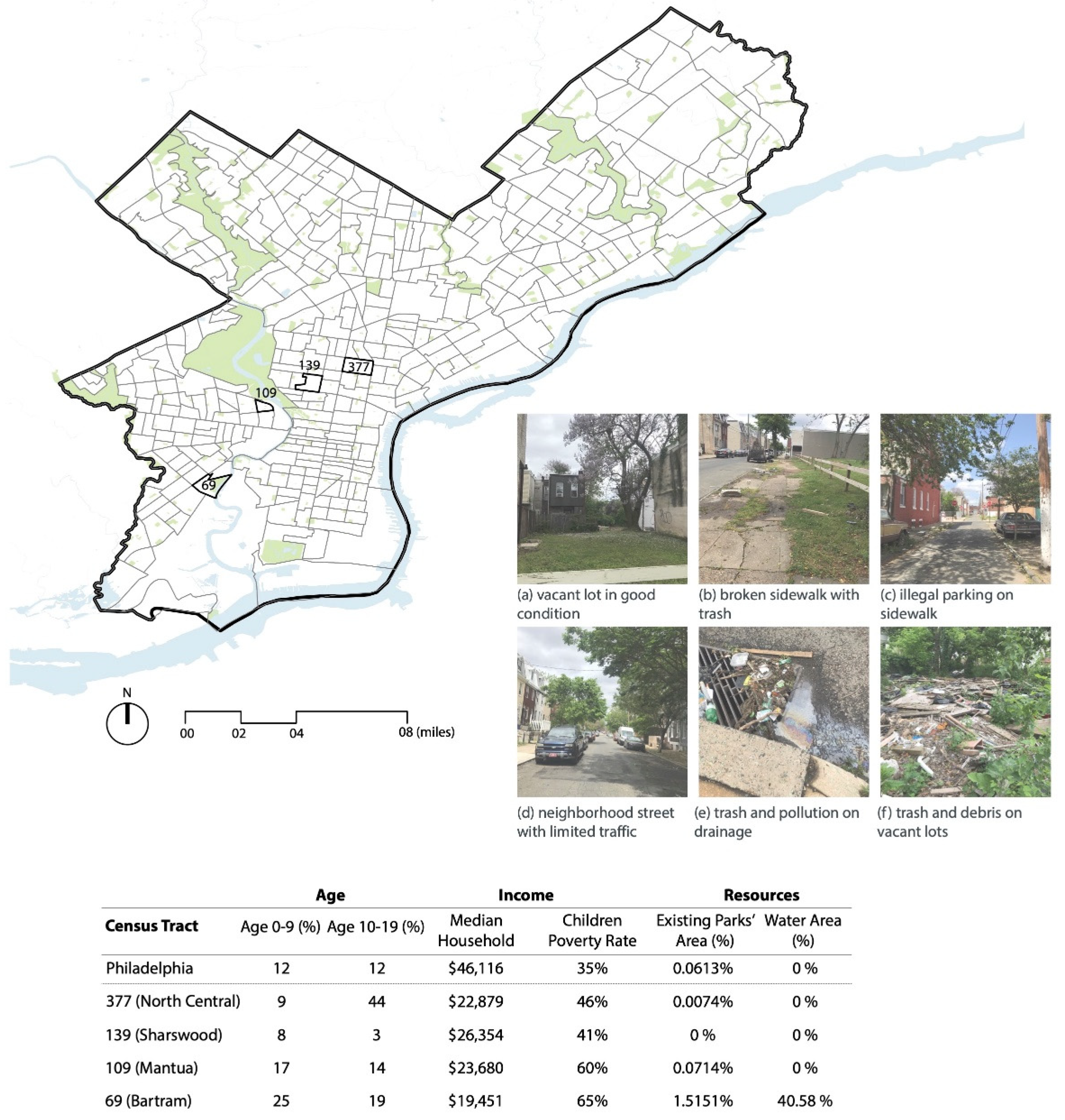
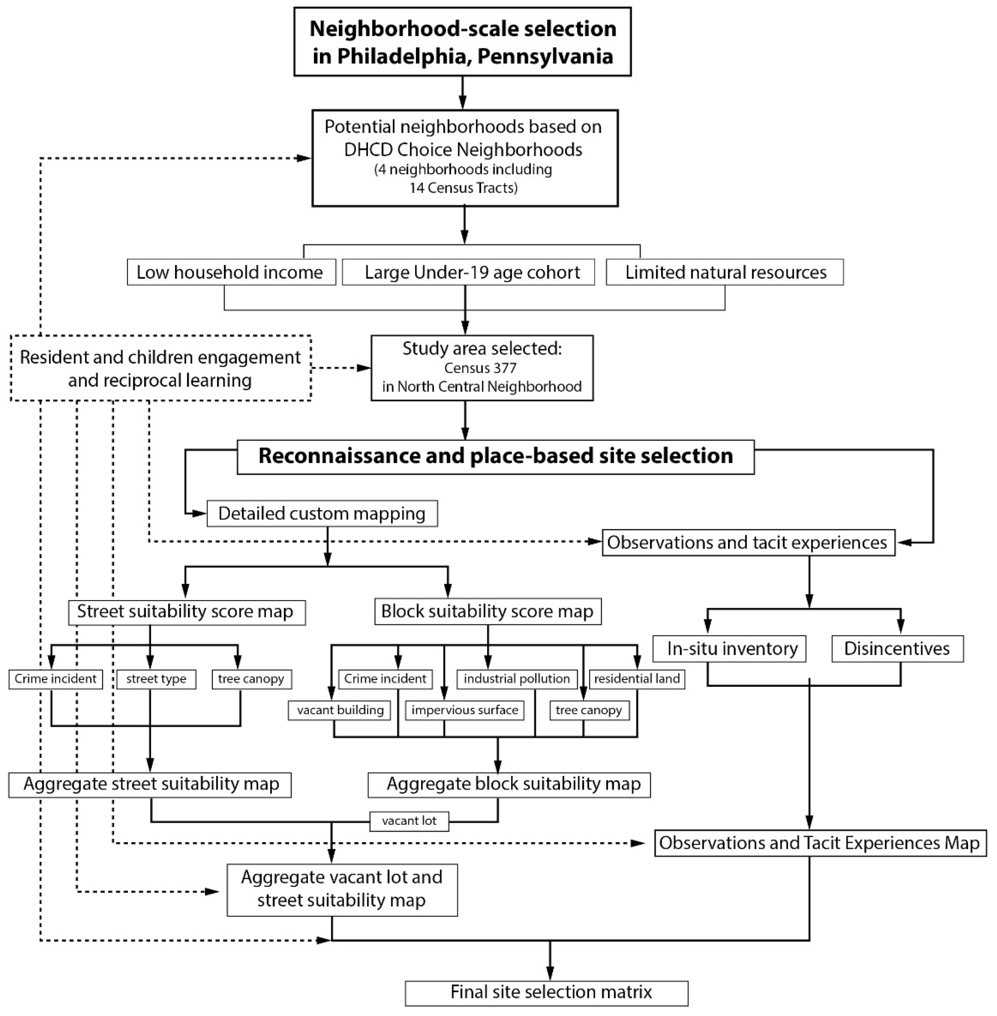
2.1. Neighborhood Selection

We selected one census tract as the area of focus from four neighborhoods chosen by the Choice Neighborhoods Initiative—a U.S. Department of Housing and Urban Development program aiming at transforming neighborhoods of extreme poverty into functioning, sustainable, mixed-income communities [32]. The four neighborhoods include fourteen Census tracts based on the U.S. Division of Housing and Community Development (DHCD). Next, we collected data from the American Community Survey 5-year estimates by the U.S. Census Bureau in 2019 [33]. Then, from 16 variables available, we selected 6 key characteristics for neighborhood comparison, which included percentages of children aged 0–9 and 10–19, median household income, children poverty rate, park area, water area, and forest coverage (see the complete list of characteristics in Table S1, Supplementary Materials). Our final selection was Census 377 in the North Central Neighborhood based on its relatively large children cohorts, low-income contexts, and scarce existing natural resources, such as parks, water, and urban forest (Figure 2).
Census Tract 377 is 0.28 square miles (73 hectares) in area and contains no water body. Fifty-three percent of its population is below 19 years of age, and 44% are in the 10 to 19-year-old cohort. It has an over-63% poverty rate among children. The median household income is $22,000 per year, less than half of the $46,116 median in Philadelphia. Additionally, the violent crime rate of the tract ranked 11th out of 46 Philadelphia neighborhoods, with 65 violent crimes in the 30 days prior to 6 January 2021, when the data was accessed. Gun violence remains a major issue in Philadelphia, especially in marginalized neighborhoods. These incidents are reported with limited follow-up and unclear root causes, which puts the neighborhood in great need of prevention strategies [34].

2.2. Reconnaissance and Site Selection

Suitability analysis and tacit experiences mapping were integrated to identify play network opportunities. McHarg’s robust work on synthesizing findings from multiple, layered sources to guide planners, designers, and stakeholders informed our GIS suitability analysis [35]. We used ArcGIS (ArcMap Version 10.8) to blend two interim suitability score maps at the street and block levels, based on relevant attributes. Each suitability map gathered data from open sources, such as land use, crime indices, street types, tree canopy coverage, and vacant buildings (Table 1). Next, an Observations and Tacit Experiences map was created based on researchers’ site observations and expertise and experience, with a focus on play opportunities and challenges not included in the ArcGIS mapping. Last, the GIS Suitability and Tacit Experiences map were aggregated into a single Play Network Opportunities map that shows a linked series of preferred locations that offers a cohesive development framework for green play infrastructure.

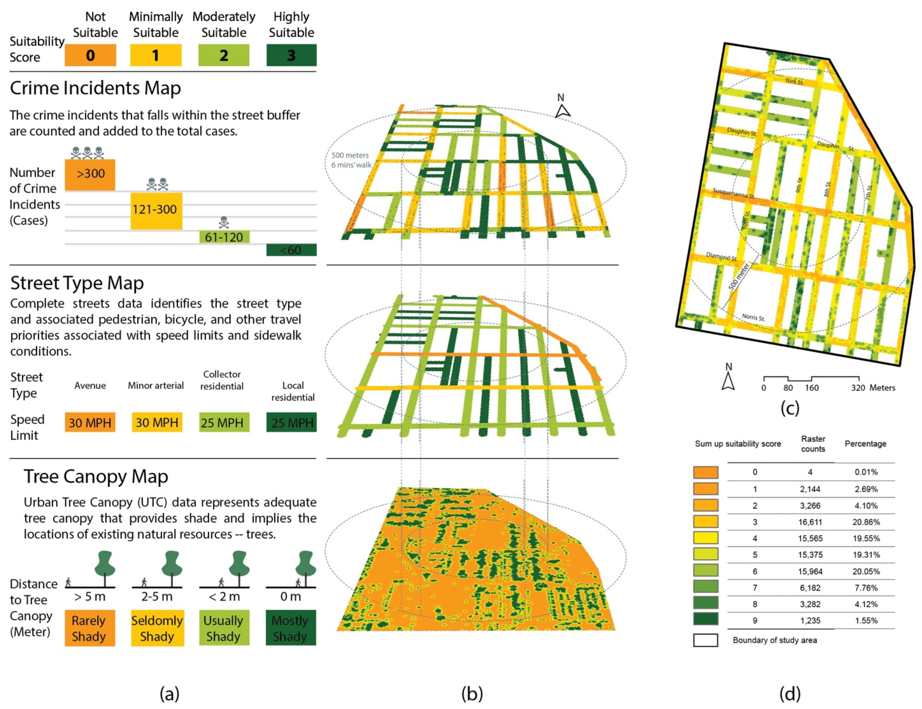
2.2.1. Street Suitability Analysis

In focusing on the role that streets can serve in advancing nature-based play, we used three major criteria: crime rate, street type, and distance to tree canopy for street suitability analysis (Figure 3). First, we generated the street space through the buffer tool of ArcMap’s proximity toolset by offsetting the street centerlines by 10 m based on the average street width of the tract—as 20 m (65.6 feet) covers almost all the crime data recorded. Second, based on the Philadelphia Police Department’s crime incident map, the total number of criminal cases from January 2006 to April 2020 that fell within 10 m from each street centerline was counted to indicate the historic crime rate for each street. Third, street types developed by the Philadelphia City Planning Commission were used to indicate travel speed limit as a suitability criterion for play safety based on the widely-held principle of “the slower speed, the safer the road” [36]. Fourth, distance to tree canopy was calculated using the urban tree canopy layer (2018) developed by Philadelphia Parks and Recreation, indicating shade conditions due to significant concerns over heat vulnerability under climate change. Last, the suitability scores of each major criteria were added together to create the Aggregated Street Suitability map with scores from 0 to 9 (Figure 3a).

2.2.2. Block Suitability Analysis

We used six major criteria in our block suitability analysis: crime incidents, distance to tree canopy, surface perviousness, and distances to occupied residential houses, vacant houses, and industrial lands (Figure 4). First, similar to the street-level analysis, crime incidents and distance to tree canopy were used to indicate the distribution of crimes and shade conditions for play within the neighborhood. Specifically, the crime data were sectored into 50 m × 50 m areas created by the fishnet tool in ArcMap. Second, surface perviousness was considered because existing permeable areas are more suitable for nature play and incur lower construction costs, which is crucial for low-income neighborhoods. Next, occupied and fully vacant houses and industrial lands were extracted from the Philadelphia Department of Planning and Development’s land use map as polygons. Distances to occupied houses were calculated to indicate safety or perception of safety due to the presence of observant residents near play interventions. In contrast, distances to fully vacant houses highlight risky and abandoned site conditions, prompting the planner to consider ways to minimize the possibility of children accessing derelict structures and grounds. On the other hand, vacancy mapping also points to opportunities for adaptive reuse of derelict and vacant properties to accommodate nature play. Additionally, distances to industrial lands were calculated to identify potential environmental risks, such as noise and air pollution, for children’s hearing and young lungs. Last, the Vacant Lot Aggregated Suitability map (Figure 4d) was created by overlaying the six individual maps and clipping the content to the vacant lot layer to highlight vacant lots as potential (re)design sites.

2.2.3. Final GIS Suitability Map

Using the method of equal intervals [37], both the Aggregated Street Suitability map (Figure 3c) and Vacant Lot Aggregated Suitability map (Figure 4d) were reclassified into five categories (i.e., not suitable, minimally suitable, moderately suitable, suitable, and highly suitable). Then, the two maps were overlaid complimentary to create the Final Suitability map (Figure 5).

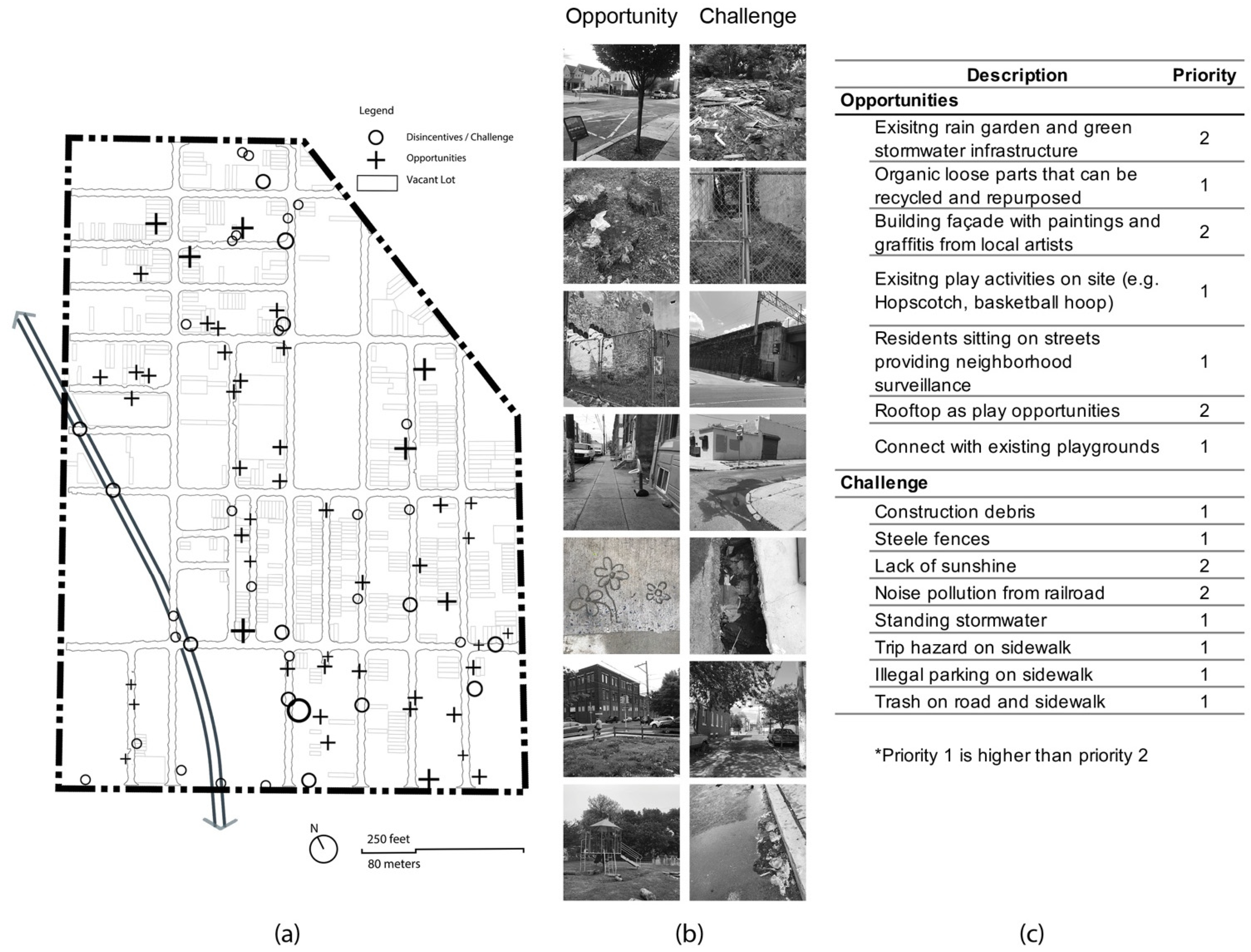
2.2.4. Observations and Tacit Experiences

Tacit learning, according to Polanyi [38], involves knowledge grounded more in sensory experience, memory, and skill than in explicit written and codified forms. Along with the GIS analyses above, we traced a ‘mixed-scanning’ approach, leveraging in situ observation and knowledge-building to complement and refine suitability mapping and develop design scenarios that reveal play opportunities and challenges.
Site visits were conducted by Author 1 over several days in May 2020. One visit was intentionally scheduled on a rainy day to observe drainage issues on vacant lots and streets. During the visits, special attention was paid to existing vacant lots (e.g., presence of fencing) and street conditions (e.g., shade, sidewalk), drainage issues, trash, and debris, urban wildlife, vegetation, existing play infrastructure (e.g., playgrounds), activities, and behaviors in the neighborhood. A total of 765 photos were taken during site visits. Extensive field notes of site opportunities and challenges were also recorded. The photos and notes were later synthesized into the Observations and Tacit Experiences map, accompanied by an Opportunities and Challenges table with priority rankings (Figure 6). For example, to avoid hazards along the play route, health and safety concerns, such as improperly disposed waste, construction debris, and sidewalk tripping hazards are high priorities. The Observations and Tacit Experiences map (Figure 6) represents a collated range of in-person and on-site experiences that inform the researchers’ intuitive design sensibilities, with an emphasis on play disincentives and opportunities.
Concurrently, the Site Observations and Tacit Experiences map, along with the extensive photo-archive of site features, were checked against the GIS suitability map to influence route and play space decisions. This helped avoid any inappropriate or unsafe conditions not recorded in GIS analysis and capture hyper-local features too nuanced or ephemeral (e.g., overhead railroad, existing play behaviors) for the earlier rounds of mapping.

2.2.5. Play Network Development

The overlay of the Observation and Tacit Experiences map with the Final Suitability map revealed a loose network of relatively continuous and safe nature-based play opportunities (Figure 7). We then focused on identifying carefully programmed nodes and linear streets based on previous suitability analyses, literature-based selection of play types, and the researchers’ implicit, experiential understanding of the neighborhood.
More specifically, first, relatively high-suitability streets and vacant lots up to 800 feet (243 m) apart (equivalent to 3-min walking distance) were selected to provide an accessible and continuous network with ample play opportunities. Next, the most prominent sources, including Loebach and Cox’s Typology for Capturing Children’s Play Behaviors in Outdoor Environments [39], Kahn Jr et al.’s keystone interaction patterns during child-nature interaction [40], and Maxwell’s discussion on types of play were used to identify eight categories of play (i.e., imaginative, biological, exploratory, expressive, restorative, physical, water and rule-based play) [41]. In addition to GIS analyses, our conclusions about which sites to (re)design and what play activities they may best accommodate were informed by our implicit, experiential understanding of local conditions and the ‘aha’ moments by simply being in the place.

3. Results and Discussion

3.1. Mapping Analyses Outcomes

The final suitability map (Figure 7) shows most of the analyzed area as ‘moderately suitable’ (31.77%) and ‘suitable’ (37.02%) for implementing the play network, with 14.71% as ‘highly suitable,’ 1.36% ‘not suitable,’ and 15.14% for ‘minimally suitable.’ The ‘highly suitable’ streets are mostly alleys, such as French Street and Edgley Street (see location A, Figure 7). Lots, on the other hand, are rarely ‘highly suitable’ for the entire lot, primarily due to limited vegetation cover and derelict surface conditions. The best example was the corner of Dauphin Street and 9th Street (see location B, Figure 7), assessed as moderately to highly suitable. Taking advantage of the existing ‘highly suitable’ areas could greatly improve the cost-efficiency of the overall play network. Those ‘suitable’ and ‘moderately suitable,’ accounting for 68.79% of the analyzed vacant lots and streets, can be prioritized and modified or redesigned during the first phase of the route design due to fair existing conditions and relatively low cost of the modification. In contrast, the ‘not suitable’ and ‘minimally suitable’ areas are mostly streets with high traffic volume and vacant lots with low nearby occupancy and potential industrial pollution, such as Susquehanna Street (location C, Figure 7) and the lot at Dauphin Street and 8th Street (location D, Figure 7). Ideally, they would also be prioritized in neighborhood regeneration projects for hazard mitigation and safety enhancement. However, due to the focus on play in a neighborhood with extremely limited resources, these unsuitable areas are avoided in most cases, except when the play route must cross a street or lot that cannot be substituted by better selections.
The GIS suitability map revealed most of the disincentives discovered by tacit mapping. A notable example was the lots adjacent to a fire-ravaged house on N 9th Street rated as ‘not suitable’ (location E, Figure 7). The windowless house showed apparent marks of a massive fire without any signs of recovery or reconstruction efforts. Property records held at the city also confirmed that no efforts for improvement had been made since 2017. Although the house was sold for $1 to a chemical firm in March 2021, it will likely be a long process for the house to recover from vacancy and its surrounding environment to become suitable for play.
Some tacit opportunities also matched the suitability map, indicating that existing suitable places already accommodated some play activity. For example, a hopscotch pattern was drawn in chalk on the sidewalk of Delhi Street near Susquehanna Street, rated as ‘suitable’ in the suitability map, signaling already initiated play activities (location F, Figure 7).
In contrast, several discrepancies showed that the GIS suitability analysis could miss nuanced opportunities and disincentives not easily quantified or mapped. For example, rooftops as opportunities may be missed by the GIS analysis that did not account for rooftop characteristics. A flat, low, and easily accessible roof of an under-used two-storey building at the corner of Percy and Diamond Streets (location G. Figure 7) illustrates such an example. It could be repurposed into a shelter for play events, with rain-harvesting features and vegetation that benefit both ecology and play. Although this vacant lot was graded only as ‘moderately suitable’ in the GIS analysis, its central location to the overall play network, the potential for the otherwise sound structure to be renovated into a play hub, and adjacent historical factory with rich architectural texture made it a potential candidate as a structured play node. Another example is the driveway on 7th Street near Diamond Street (location H, Figure 7), rated as ‘suitable’ in GIS analysis but presented apparent stormwater ponding and pollution based on the on-site documentation. Such sites can be reconsidered after drainage issues are addressed at a larger scale.
In short, observations and tacit experience verified most results from the suitability map while also contributing significantly to identifying nuanced disincentives or opportunities that were missed in the GIS mapping process.

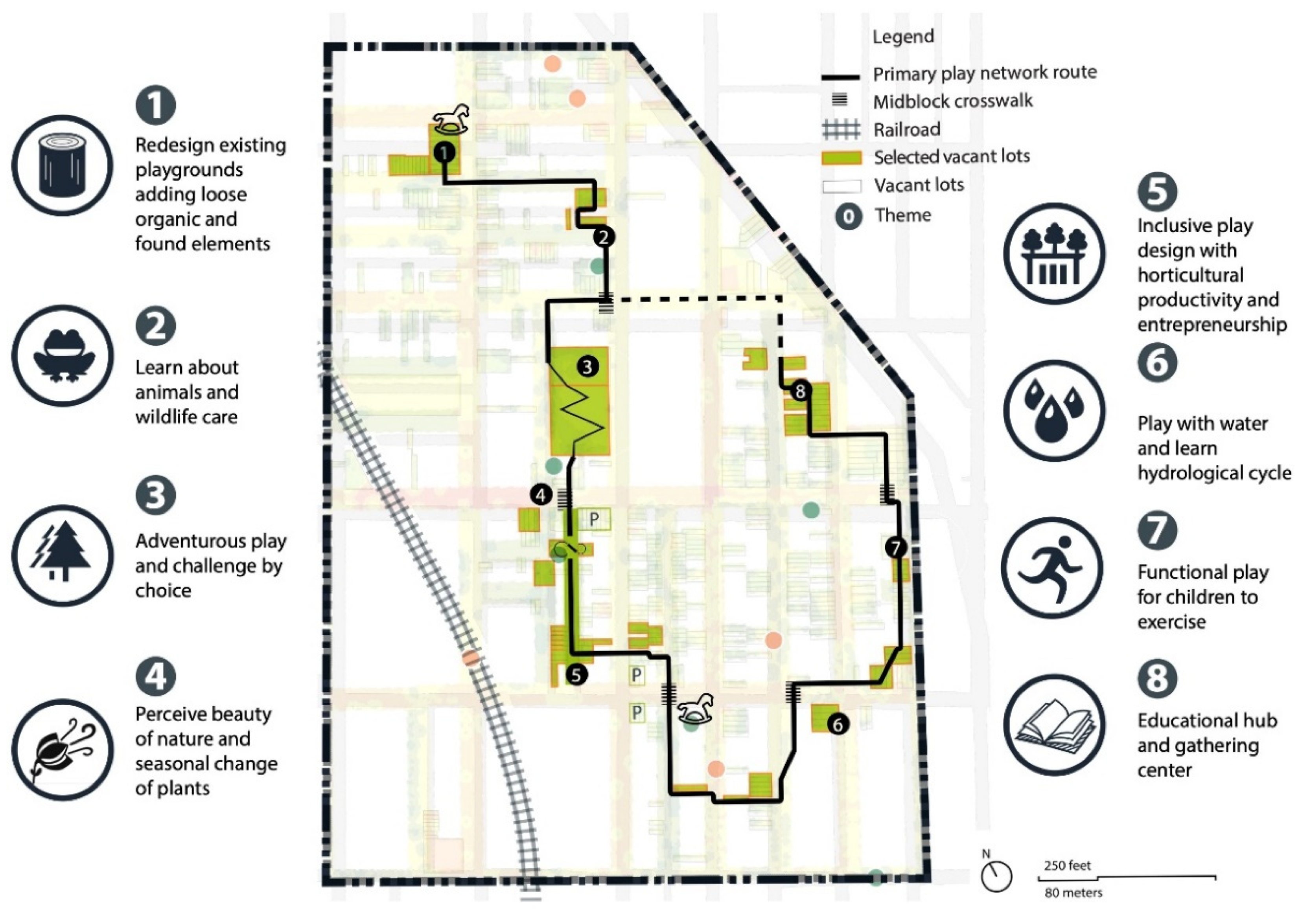
3.2. Play Network and Themes

The resultant play network map includes eight themed sites (Figure 8) that embrace different play opportunities and addresses critical challenges in this neighborhood. These themed sites are ‘highly suitable’ to ‘suitable’ sites identified from the previous session. The themes were selected to fit the social and biophysical context of the study area and further guide and frame site design opportunities. For example, the water play theme (theme #6) provides children opportunities to play with water while gaining tactile experience with hydrological cycles. The associated site was chosen because it is close to several tree trenches from the existing green stormwater infrastructure. The descriptions of the themes, rationale, design considerations, and activity examples are summarized in Table 2 and explained in detail below.
Play theme #1 targets Imaginative play that involves objects, actions, or ideas in the environment and is usually guided by adults [39]. We propose redesigning an existing playground at the southwest intersection of N. 10th and W. Dakota Streets with a low-cost approach. The design strategy is to maintain the existing play infrastructure, including the climbing tower, monkey bar, and slides, and enhance the natural play environment by adding loose organic and found natural elements as sources of play.
Play theme #2 is Bio play, where a child observes or interacts with living plants or wildlife or acts in a way that demonstrates both curiosity and care for the environment. This theme introduces children to local urban wildlife, such as herptiles (e.g., green frog, American toad, Spring peeper, treefrog, and garter snake), songbirds (e.g., goldfinch, barn swallow, nuthatch, chickadee), a wide range of pollinators, and much more. Children are provided with tools like binoculars, sweep nets, hand lenses, as well as resource guides, journals, and pens for observations on-site. They will get to know other ‘next-door’ creatures living together with them in their neighborhood. This play activity is educational and fun since children tend to be drawn to a diverse range of smaller animals.
Play theme #3 supports Exploratory play, including passive exploration through senses, active play through manipulating objects or the site’s mini-ecosystems, and constructive play that involves building and making [39]. This theme provides children with opportunities for adventurous play and a range of challenging play choices.
Play theme #4, Expressive play, was inspired by Aristotle’s axiom, “Nature is what we call interacting things that have the power to change or grow themselves.” This is where children can perceive the beauty of everyday life through natural installations or sense the productivity of nature during harvest seasons through agricultural activities.
Play theme #5, Restorative play, aims to provide a playscape for all, involving not only active places but also quiet activities like resting and retreating. These inclusive playscapes can help children of all abilities become more confident, meet friends, and build essential skills, meanwhile increasing people’s acceptance by mitigating biases about those children with disabilities.
Play theme #6 introduces Water play and the hydrological cycle of the site. Surrounded by multiple tree trenches installed from the “Soak it Up, Philly!” program by the Philadelphia Water Department [42], this site can use rainwater for play to lower maintenance, create opportunities for kids to interact with water, and enhance local biodiversity. Children can observe water on its journey from roofs and pavements through natural features that can both store and slow down the flow of water while reducing pollutants and sustaining plants and animals.
Play theme #7 introduces Physical play, including running, biking, climbing, and other exercising activities. Physical activity contributes to preventing and managing noncommunicable diseases, such as cardiovascular diseases, cancer, and diabetes. The World Health Organization recommends that school children get 60 min of moderate to vigorous activity every day [43]. Underserved neighborhoods suffer the burden of chronic diseases and related risks due to low-income and other social issues. This theme provides children access to balls, hula-hoops, and other furnishings and play objects that support physical activities, thus reducing obesity risk and improving overall physical and mental health.
Lastly, play theme #8, Rule-based play, focuses on the educational programs of guided play. This theme includes large gathering areas and materials needed in the educational programs for children to reflect on what they learn in their daily play activities. The outdoor classroom offers an alternative location for peer group learning and supplements indoor classroom learning with more engagement because nature can bolster children’s attention through stress reduction [44].

3.3. Implications for Practice and Research

Starting from the city scale, this project provides a community-scale spatial structure of a nature play network for a neighborhood with a dearth of green play infrastructure. Compared with their more privileged counterparts, children in such impoverished urban contexts are associated with decreased playground access and lower levels of playground safety [45]. The two playgrounds that do exist in the study area are of low quality, poorly maintained, and effectively detached from ecological processes and nature-based materials. Nature-based playscapes leverage existing resources, thus, relatively modest investments can bring significant contributions to the regeneration of the neighborhood environment. Low-income neighborhoods could see green play infrastructure as a timely opportunity to improve street conditions, increase green coverage, decrease crime, and enhance neighborhood vitality. Outcomes of projects, such as those proposed herein can aid communities’ efforts in securing funding for real-world implementations that could catalyze profound neighborhood changes. The network with relatively small-scale projects can also be implemented incrementally by local planning councils and neighborhood organizations.
The project outlined above results from a comprehensive and transferable nature-play methodology—a blended approach to GIS-based and on-site mapping, programming, and nature play design that interweaves explicit spatial data with tacit knowledge. Nature play applications remain scarce in geospatial suitability mapping projects, which tend to focus on commercial or industrial uses (e.g., supermarkets, wind farms) [46,47]. The suite of suitability criteria we developed explicitly for nature play based on widely available public data can be referenced or adapted in other projects based on local conditions and study objectives.
In most conventional cases, the design of nature play focuses on independent design sites and rarely considers a connected system. Findings show that children’s ability to move freely and independently within their local communities is fundamental to environmental child-friendliness [48]. Although isolated sites provide some play opportunities, they cannot fulfill children’s needs for more freely explored play spaces that should not be confined to one playground. Moreover, the continuous multi-functional play network with nodes and safe streets proposed above illustrates how a community’s spatio-ecological infrastructure could simultaneously be enhanced.
Geospatial mapping tools such as ArcGIS are typically applied with inadequate integration of tacit knowledge. Over-reliance on secondary datasets may lead to neglecting elements or opportunities that may be critical to constructing a nature play system. Interweaving tacit and experiential knowledge informs opportunities and challenges that are difficult to capture through existing databases; such ‘site truthing’ also verifies the accuracy of the suitability maps. Overall, a research-based method that matches literature-informed themes to nature play realities on-site offers a transferable approach for planners and designers in tailoring solutions to actual neighborhood and site conditions.
This study contributes to both nature play research and practice. However, several limitations suggest adapted approaches for future investigations. First, constraints by the COVID-19 pandemic during the study period precluded a meaningful engagement process with residents (especially children) in programming the play network. As primary users and future civil society stakeholders [49], children’s involvement in the design process is essential because they know what they like, and their perspectives are uniquely distinct from those of adults. The local community is inherently steeped in the informal culture and habits of their own neighborhood. Engaged design with residents is thus vital to bolstering a community’s sense of authorship and advocacy and its confidence in further refining the location of the play network and themes [50]. Second, additional site-based analyses at varied diurnal, weekly and seasonal cycles in the community are likely to produce a more comprehensive inventory of site features and activities—in particular children’s activities after school and during the summer holidays. Finally, our suitability analyses were constrained by the lack of finer-grained block-level census data that could have better informed the configuration of play themes targeting specific age groups in each block.

4. Conclusions

We applied literature-informed themes that combined GIS analyses and tacit knowledge in conceptualizing a play network in an underserved neighborhood in Philadelphia, Pennsylvania. Considering the diversity of play values and ecological literacies, we identified opportunities for safe, engaging, and varied natural play settings and provided a list of play activity examples for children in this neighborhood. From this study, we demonstrated a new model with practical methods that could be broadly applicable to guide designs for nature-based play in similar communities.
Numerous studies have emphasized the relationship between proximity to nature and elements of neighborhood resilience in reference to the importance of green space. In response to the extremely limited opportunities for children to interact playfully with naturalistic ecologies in underserved urban areas, studies such as ours may play a role in guiding long-term neighborhood open space changes. Our method innovates in its blending of select, accessible GIS-based spatial data analyses and experiential tacit findings as a basis for a green play strategy that offers stimulating, educational, and safe nature play opportunities for underserved children in the city. This mixed-method approach is affordable and may serve as a replicable guide for similar studies searching nature play locations that eventually form a play system. The development of even parts of a play network may jumpstart broader environmental enhancements and catalyze fundamental socio-economical improvements in at-risk neighborhoods.
However, green play infrastructure requires more than the spatial framework we illustrate above to be ultimately implemented in underserved communities. Various barriers remain to be overcome: resource availability from construction to maintenance, outdated or overly constraining municipal and state regulations, and a systemic underappreciation of nature play benefits by decision-makers and stakeholders. Green play infrastructure programming and design will inevitably become entangled with other complex socio-economic challenges that are inherent in underserved, low-income neighborhoods. Making natural landscapes and green installations strategically available for play demands new attitudes and criteria in policy and participatory design to ensure safety, accessibility, wear-resistance, and affordability [51]. The mixed-methods described above fill a gap in the children’s play literature and introduce the idea of green play infrastructure as a key strategy in improving the lives of children in disadvantaged neighborhoods.

Supplementary Materials

The following are available online at https://www.mdpi.com/article/10.3390/land11030350/s1, Table S1: Rationale for neighborhood selection; Table S2: Suitability matrix.

Author Contributions

Conceptualization, Y.Z. and K.T.; methodology, Y.Z. and K.T.; software, Y.Z.; formal analysis, Y.Z.; investigation, Y.Z.; resources, Y.Z. and K.T.; data curation, Y.Z.; writing—original draft preparation, Y.Z. and K.T.; writing—review and editing, Y.Z., H.W. and K.T.; visualization, Y.Z.; supervision, K.T. and H.W.; project administration, Y.Z.; funding acquisition, K.T. All authors have read and agreed to the published version of the manuscript.

Funding

This research was funded through Pennsylvania State University’s College of Arts & Architecture.

Acknowledgments

A preliminary version of this paper was presented at the 17th International Conference on Computational Urban Planning & Urban Management, 2021.

Conflicts of Interest

The authors declare no conflict of interest.

References

  1. Dewi, S.P. How Does the Playground Role in Realizing Children-Friendly-City? Procedia—Soc. Behav. Sci. 2012, 38, 224–233. [Google Scholar] [CrossRef] [Green Version]
  2. Berg, M.; Medrich, E.A. Children in Four Neighborhoods: The Physical Environment and Its Effect on Play and Play Patterns. Environ. Behav. 1980, 12, 320–348. [Google Scholar] [CrossRef]
  3. Jansson, M.; Sundevall, E.; Wales, M. The Role of Green Spaces and Their Management in a Child-Friendly Urban Village. Urban For. Urban Green. 2016, 18, 228–236. [Google Scholar] [CrossRef] [Green Version]
  4. Rowland-Shea, J.; Edberg, S.; Doshi, S.; Fanger, R. The Nature Gap: Confronting Racial and Economic Disparities in the Destruction and Protection of Nature in America; Center for American Progress: Washington, DC, USA, 2020. [Google Scholar]
  5. Sprague, N.; Berrigan, D.; Ekenga, C.C. An Analysis of the Educational and Health-Related Benefits of Nature-Based Environmental Education in Low-Income Black and Hispanic Children. Health Equity 2020, 4, 198–210. [Google Scholar] [CrossRef]
  6. Vaughan, K.B.; Kaczynski, A.T.; Wilhelm Stanis, S.A.; Besenyi, G.M.; Bergstrom, R.; Heinrich, K.M. Exploring the Distribution of Park Availability, Features, and Quality Across Kansas City, Missouri by Income and Race/Ethnicity: An Environmental Justice Investigation. Ann. Behav. Med. 2013, 45, S28–S38. [Google Scholar] [CrossRef] [PubMed] [Green Version]
  7. Dearing, E.; Wimer, C.; Simpkins, S.D.; Lund, T.; Bouffard, S.M.; Caronongan, P.; Kreider, H.; Weiss, H. Do Neighborhood and Home Contexts Help Explain Why Low-Income Children Miss Opportunities to Participate in Activities Outside of School? Dev. Psychol. 2009, 45, 1545–1562. [Google Scholar] [CrossRef]
  8. Fjørtoft, I. Landscape as Playscape: The Effects of Natural Environments on Children’s Play and Motor Development. Child. Youth Environ. 2004, 14, 21–44. [Google Scholar]
  9. Boyer, T. The Development of Risk-Taking: A Multi-Perspective Review. Dev. Rev. 2006, 26, 291–345. [Google Scholar] [CrossRef]
  10. Kellert, S.R.; Heerwagen, J.; Mador, M. Biophilic Design: The Theory, Science and Practice of Bringing Buildings to Life; John Wiley & Sons: Hoboken, NJ, USA, 2011; ISBN 1-118-17424-0. [Google Scholar]
  11. Salingaros, N.A. The Biophilic Healing Index Predicts Effects of the Built Environment on Our Well-being. J. Biourban. 2019, 8, 13–34. [Google Scholar]
  12. Groos, K. The Psychology of Animal Play. In The play of Animals; Baldwin, E.L., Baldwin, J.M., Eds.; D Appleton & Company: New York, NY, USA, 1898; pp. 287–328. [Google Scholar]
  13. Huizinga, J.; Iudens, H. A Study of the Play Element in Culture; Beacon: Boston, MA, USA, 1955. [Google Scholar]
  14. Johnson, J.E.; Christie, J.F.; Wardle, F. Play, Development, and Early Education; Pearson/Allyn and Bacon: Boston, MA, USA, 2005. [Google Scholar]
  15. Koralek, D. Spotlight on Young Children and the Creative Arts; ERIC: Ipswich, MA, USA, 2005; ISBN 1-928896-23-5. [Google Scholar]
  16. Hayward, D.G.; Rothenberg, M.; Beasley, R.R. Children’s Play and Urban Playground Environments: “A Comparison of Traditional, Contemporary, and Adventure Playground Types”. Environ. Behav. 1974, 6, 131. [Google Scholar]
  17. Altan, M.Z. Intelligence Reframed: Multiple Intelligences for the 21st Century: Howard Gardner. TESOL Q. 2001, 35, 204–205. [Google Scholar] [CrossRef]
  18. Gardner, H. The Theory of Multiple Intelligences; Heinemann London: Portsmouth, NH, USA, 1983; ISBN 0-434-28245-6. [Google Scholar]
  19. Chawla, L. Benefits of Nature Contact for Children. J. Plan. Lit. 2015, 30, 433–452. [Google Scholar] [CrossRef]
  20. Brussoni, M.; Ishikawa, T.; Brunelle, S.; Herrington, S. Landscapes for Play: Effects of an Intervention to Promote Nature-Based Risky Play in Early Childhood Centres. J. Environ. Psychol. 2017, 54, 139–150. [Google Scholar] [CrossRef]
  21. Orr, D.W. Ecological Literacy: Education and the Transition to a Postmodern World; Suny Press: Albany, NY, USA, 1992; ISBN 0-7914-0873-6. [Google Scholar]
  22. Hammarsten, M.; Askerlund, P.; Almers, E.; Avery, H.; Samuelsson, T. Developing Ecological Literacy in a Forest Garden: Children’s Perspectives. J. Adventure Educ. Outdoor Learn. 2019, 19, 227–241. [Google Scholar] [CrossRef] [Green Version]
  23. Sachs, N.A.; Rakow, D.A.; Shepley, M.M.; Peditto, K. The Potential Correlation Between Nature Engagement in Middle Childhood Years and College Undergraduates’ Nature Engagement, Proenvironmental Attitudes, and Stress. Front. Psychol. 2020, 11, 2919. [Google Scholar] [CrossRef]
  24. Staempfli, M.B. Reintroducing Adventure Into Children’s Outdoor Play Environments. Environ. Behav. 2009, 41, 268–280. [Google Scholar] [CrossRef]
  25. Forsyth, A.; Musacchio, L. Designing Small Parks: A Manual for Addressing Social and Ecological Concerns; John Wiley & Sons: Hoboken, NJ, USA, 2005; ISBN 0-471-73680-5. [Google Scholar]
  26. Crewe, K.; Forsyth, A. LandSCAPES: A Typology of Approaches to Landscape Architecture. Landsc. J. 2003, 22, 37–53. [Google Scholar] [CrossRef]
  27. Rigolon, A.; Browning, M.; Jennings, V. Inequities in the Quality of Urban Park Systems: An Environmental Justice Investigation of Cities in the United States. Landsc. Urban Plan. 2018, 178, 156–169. [Google Scholar] [CrossRef]
  28. Casey, J.A.; James, P.; Cushing, L.; Jesdale, B.M.; Morello-Frosch, R. Race, Ethnicity, Income Concentration and 10-Year Change in Urban Greenness in the United States. Int. J. Environ. Res. Public Health 2017, 14, 1546. [Google Scholar] [CrossRef] [Green Version]
  29. Hochschild, T.R., Jr. Cul-de-Sac Kids. Childhood 2013, 20, 229–243. [Google Scholar] [CrossRef]
  30. Carr, V.; Brown, R.D.; Schlembach, S.; Kochanowski, L. Nature by Design: Playscape Affordances Support the Use of Executive Function in Preschoolers. Child. Youth Environ. 2017, 27, 25–46. [Google Scholar] [CrossRef]
  31. National Recreation and Park Association Park Metrics. Available online: https://www.nrpa.org/publications-research/ParkMetrics/ (accessed on 26 January 2022).
  32. Choice Neighborhoods Initiative. Available online: https://www.phila.gov/departments/division-of-housing-and-community-development/about/choice-neighborhoods-initiative/ (accessed on 22 January 2022).
  33. Census Profile: Census Tract 377, Philadelphia, PA. Available online: http://censusreporter.org/profiles/14000US42101037700-census-tract-377-philadelphia-pa/ (accessed on 26 March 2021).
  34. Gun Violence: A Reckoning—Penn Medicine. Available online: https://www.pennmedicine.org/news/publications-and-special-projects/penn-medicine-magazine/winter-2022/gun-violence-a-reckoning (accessed on 20 February 2022).
  35. McHarg, I.L. Design with Nature; American Museum of Natural History: New York, NY, USA, 1969; ISBN 0-385-02142-9. [Google Scholar]
  36. Dumbaugh, E.; Li, W. Designing for the Safety of Pedestrians, Cyclists, and Motorists in Urban Environments. J. Am. Plan. Assoc. 2010, 77, 69–88. [Google Scholar] [CrossRef]
  37. GISGeography Equal Interval Classification in GIS. Available online: https://gisgeography.com/equal-interval-classification-gis/ (accessed on 22 January 2022).
  38. Polanyi, M. The Tacit Dimension; University of Chicago Press: Chicago, IL, USA, 2009; ISBN 0-226-67298-0. [Google Scholar]
  39. Loebach, J.; Cox, A. Tool for Observing Play Outdoors (TOPO): A New Typology for Capturing Children’s Play Behaviors in Outdoor Environments. Int. J. Environ. Res. Public Health 2020, 17, 5611. [Google Scholar] [CrossRef]
  40. Kahn, P.H., Jr.; Weiss, T.; Harrington, K. Modeling Child–Nature Interaction in a Nature Preschool: A Proof of Concept. Front. Psychol. 2018, 9, 835. [Google Scholar] [CrossRef] [Green Version]
  41. Maxwell, L.E.; Mitchell, M.R.; Evans, G.W. Effects of Play Equipment and Loose Parts on Preschool Children’s Outdoor Play Behavior: An Observational Study and Design Intervention. Child. Youth Environ. 2018, 18, 36–63. [Google Scholar]
  42. Green Infrastructure Projects throughout Philadelphia. Available online: https://www.arcgis.com/apps/webappviewer/index.html?id=c5d43ba5291441dabbee5573a3f981d2 (accessed on 26 February 2022).
  43. WHO. Physical Activity Key Facts. Available online: https://www.who.int/news-room/fact-sheets/detail/physical-activity (accessed on 26 February 2022).
  44. The Surprising Benefits of Teaching a Class Outside. Available online: https://greatergood.berkeley.edu/article/item/the_surprising_benefits_of_teaching_a_class_outside (accessed on 26 February 2022).
  45. Cradock, A.L.; Kawachi, I.; Colditz, G.A.; Hannon, C.; Melly, S.J.; Wiecha, J.L.; Gortmaker, S.L. Playground Safety and Access in Boston Neighborhoods. Am. J. Prev. Med. 2005, 28, 357–363. [Google Scholar] [CrossRef] [PubMed]
  46. Sánchez-Lozano, J.M.; García-Cascales, M.S.; Lamata, M.T. GIS-Based Onshore Wind Farm Site Selection Using Fuzzy Multi-Criteria Decision Making Methods. Evaluating the Case of Southeastern Spain. Appl. Energy 2016, 171, 86–102. [Google Scholar] [CrossRef]
  47. Rikalovic, A.; Cosic, I.; Lazarevic, D. GIS Based Multi-Criteria Analysis for Industrial Site Selection. Procedia Eng. 2014, 69, 1054–1063. [Google Scholar] [CrossRef] [Green Version]
  48. Kyttä, M.; Oliver, M.; Ikeda, E.; Ahmadi, E.; Omiya, I.; Laatikainen, T. Children as Urbanites: Mapping the Affordances and Behavior Settings of Urban Environments for Finnish and Japanese Children. Child. Geogr. 2018, 16, 319–332. [Google Scholar] [CrossRef] [Green Version]
  49. Clark, A. Transforming Children’s Spaces: Children’s and Adults’ Participation in Designing Learning Environments; Routledge: Oxfordshire, UK, 2010; ISBN 1-135-15818-5. [Google Scholar]
  50. Tamminga, K.; De Ciantis, D. Resilience, Conviviality, and the Engaged Studio. J. High. Educ. Outreach Engagem. 2012, 16, 115–152. [Google Scholar]
  51. Fjùrtoft, I.; Sageie, J. The Natural Environment as a Playground for Children Landscape Description and Analyses of a Natural Playscape. Landsc. Urban Plan. 2000, 48, 83–97. [Google Scholar] [CrossRef]
Figure 1. Method flow of study venue selection and mapping.
Land 11 00350 g001
Figure 2. Census Tract 377 (Philadelphia, PA, USA) was chosen as the study area based on demographics, income, and natural resources conditions.
Land 11 00350 g002
Figure 3. (a) Suitability Matrices for Streets; (b) Individual Street Suitability maps; (c) Aggregated Street Suitability map; (d) Street Suitability Score summary table.
Land 11 00350 g003
Figure 4. (a) Suitability matrices for blocks; (b) Individual Block Suitability maps; (c) Aggregated Block Suitability map; (d) Vacant Lot Aggregated Suitability map; (e) Vacant Lot Suitability Score summary table.
Land 11 00350 g004
Figure 5. Final GIS Suitability map.
Land 11 00350 g005
Figure 6. (a) Observation and Tacit Experiences map; (b) Examples of opportunities and challenges captured by photos; (c) synthesis priority table.
Land 11 00350 g006
Figure 7. The Final suitability map—An Overlay of the Observation and Tacit Knowledge map.
Land 11 00350 g007
Figure 8. Play network and themes.
Land 11 00350 g008
Table 1. Characteristics of GIS data layers.
Suitability Map LayersRaw Data (Description)Raw Data SourcePeriodData Type
City of
Philadelphia
city limitsDepartment of Planning and Development2012polygon
Crime
incidents
crime incidentsPhiladelphia Police Department2006–2020point
Street typecomplete streets (combines the street types for associated pedestrian, bicycle, and other travel priorities)Mayor’s Office of Transportation and Utilities2014polyline
Urban tree
canopy
urban tree canopy outlines (outlines and points generated by Intergraph Government Solutions (IGS) for trees > 6′ diameter)Philadelphia Parks and Recreation (PPR)2015polygon
Impervious
surface
impervious surfacesPhiladelphia Water Department (PWD)2004polygon
Residential house occupancyland use (residential land)Department of Planning and Development2014polygon
Fully vacant
houses
land use (vacant building)Department of Planning and Development2014polygon
Industrial
pollution
land use (industrial)Department of Planning and Development2014polygon
Table 2. Play themes for each site (adapted from Loebach & Cox, 2020).
ThemeTheme DescriptionExisting Site Condition/RationaleActivity Examples
1. Imaginative playThe play involves using an object as a symbol for something elseSpacious existing playgrounds with seating; easy to add loose organic, found elements, and other toysMud kitchen, outdoor painting events
2. Bio playWhere a child observes, discusses, or interacts with a living plant, wildlife or acts in a way that demonstrates care of the environmentSeveral adjacent existing vacant lots; can be combined and modified into a meadow for children to interact and observeMeadow for butterfly watching, insect scavenger hunt, bee hotel observation
3. Exploratory playPlayful activities including sensory, active, and constructive playLargest vacant lot in the neighborhood; can be modified into a mini-forest for children to exploreAdventurous play with various challenge levels
4. Expressive playPerforming for others or conversationVacant lot with good visibility; can be modified into an outdoor performance spaceSinging, making stories, discussing
5. Restorative playQuiet activities like resting and retreatingVacant lot near a less busy road; good site privacy and open view of other adjacent play sitesSitting in the shade, visually exploring the environment, reading a book
6.Water playPlay activities involving waterConsists of existing green stormwater infrastructure (GSI); can further incorporate play or environmental education into GSIObserve rain garden, rainwater reuse, or visible hydrological cycle on-site
7. Physical playActivities that utilize muscles, or playful physical contact between friendsSeveral continuous vacant lots; can be modified into a large activity space or fieldSports fields for exercises, running, biking, climbing, balancing
8. Rule-based playPlay with pre-established sets of rules governing the activityRelatively clean vacant lots at a central location; adequate residents to involve for games; open sites can be modified for group events and educationEducational hub, outdoor classroom, hide-and-seek
Publisher’s Note: MDPI stays neutral with regard to jurisdictional claims in published maps and institutional affiliations.

