
Diversification and Spatial Differentiation of Villages’ Functional Types in the New Period of China: Results from Hierarchical Urban-Rural Spatial Relations and Townships Size

Abstract
:1. Introduction
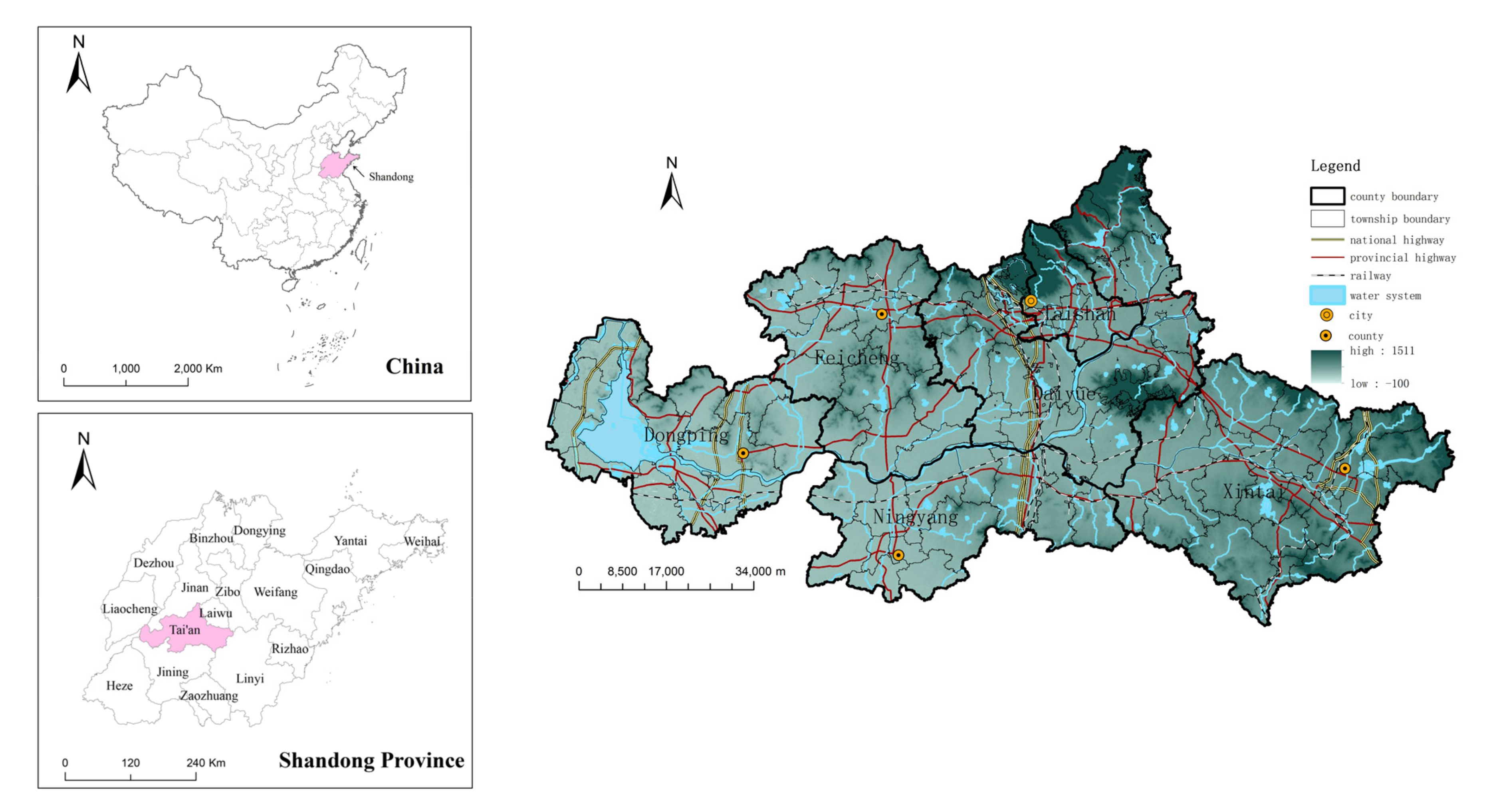
2. Study Area
3. Materials and Methods
3.1. Data Sources
3.2. Analysis Methods
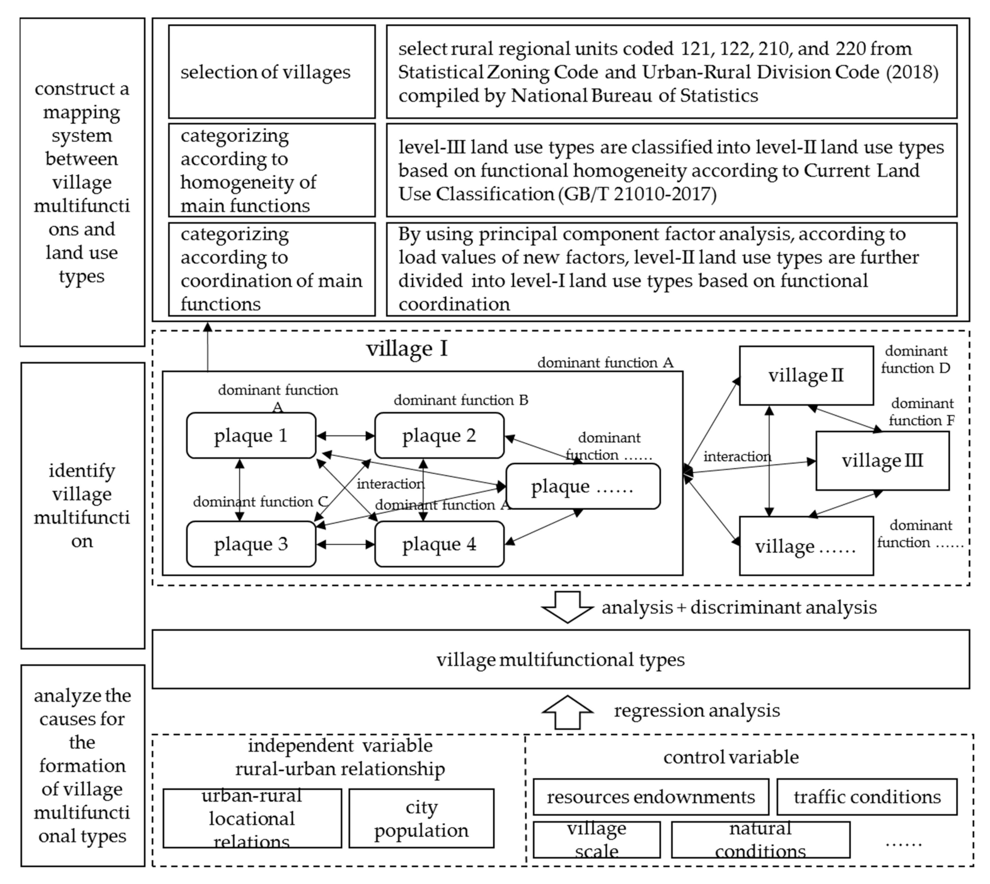
3.2.1. Identification of Village Multifunctional Types
3.2.2. Identification of Influencing Factor
- (1)
- Selection of Variables
- (2)
- Selection of Models
4. Results
4.1. Rural Territorial Sub-Functions Mapped by Land Use Types
4.1.1. Level-III Land Use Types Are Combined and Categorized According to Homogeneity
4.1.2. Level-II Land Use Types Are Combined and Categorized According to Co-Occurrence and Synergy
- (1)
- Common factor 1: land for the public, commerce, and business—service function.
- (2)
- Common factor 2: land for industrial storage and transportation—industrial productions function.
- (3)
- Common factor 3: forest land and garden plots—production of woods and gardens and ecological conservation.
- (4)
- Common factor 4: dry land and mining land—dry agriculture and mining production function.
- (5)
- Common factor 5: paddy field and water area—paddy agriculture and fishery production-ecological conservation function.
- (6)
- Common factor 6: irrigated land and facility farmland—irrigating agriculture and facility agriculture production function.
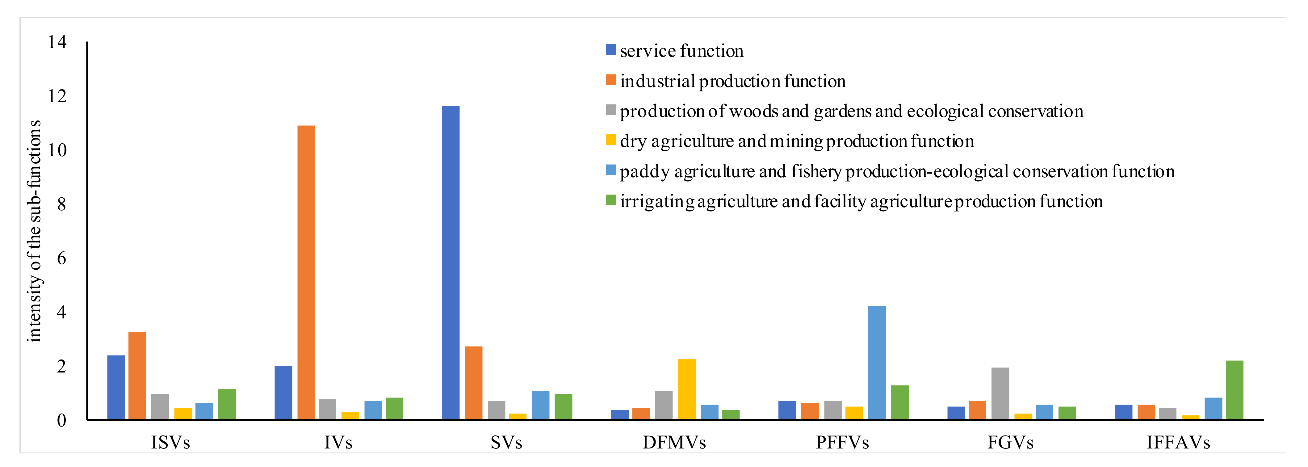
4.2. Structure of Administrative Village Multifunctional Types
4.3. Influencing Factors of Administrative Village Multifunctional Types
- (1)
- Industry-oriented villages (IVs)
- (2)
- Service-oriented villages (SVs)
- (3)
- Integrated-function type villages with both industrial production and service (ISIVs).
- (4)
- Paddy farming and fishery-oriented villages (PFFVs)
- (5)
- Dry farming and mining-oriented villages (DFMVs)
- (6)
- Forest and garden-oriented villages (FGVs)
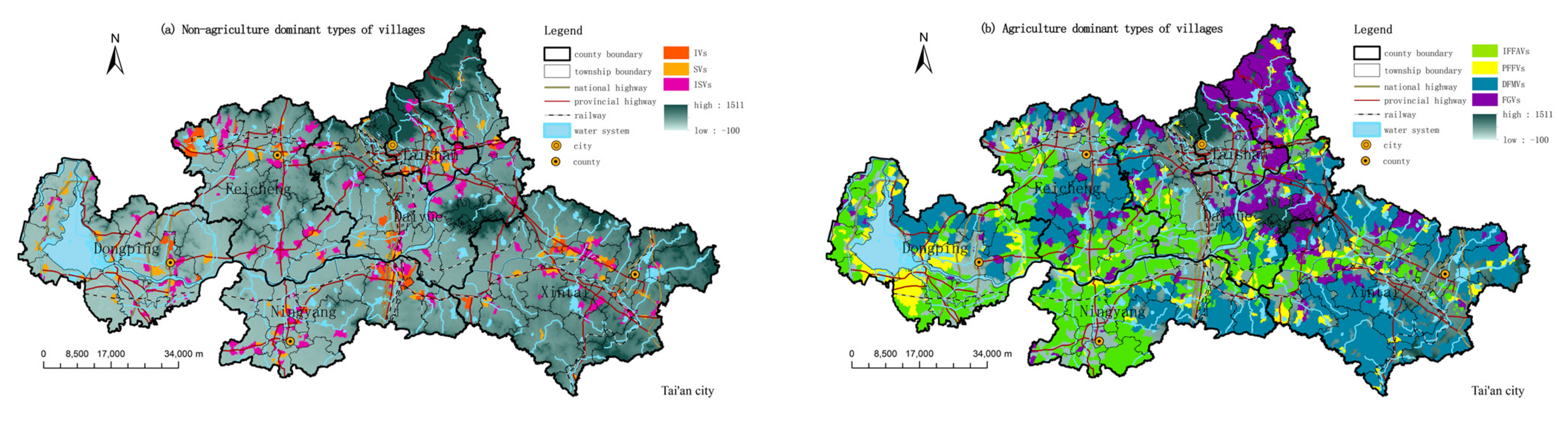
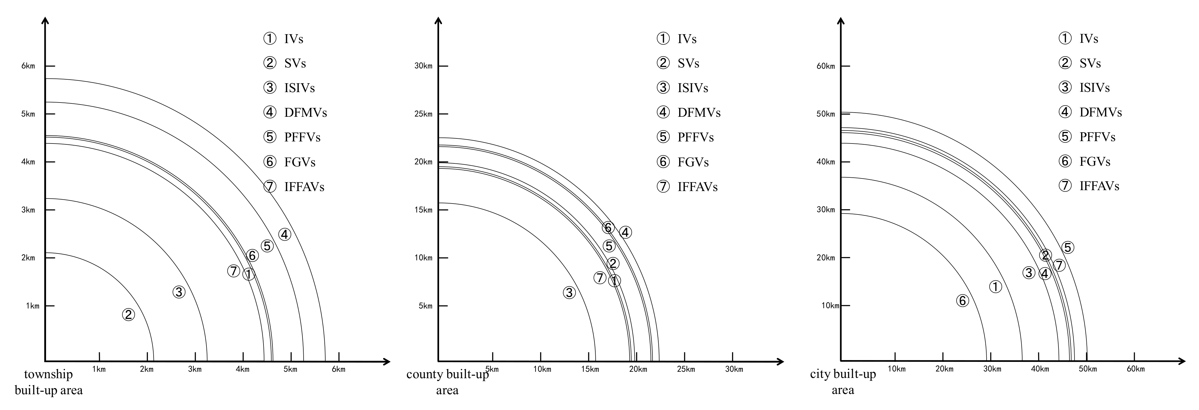
4.4. Spatial Structure of Administrative Village Multifunctional Types
5. Discussion
5.1. Rural Territorial Muiltfunctions and Land Use Muiltfunctions Have a Mapping Link
5.2. Diversified Characteristics of Administrative Village Multifunctional Types Are Obvious
5.3. Administrative Village Multifunctional Types Are Significantly Influenced by Urban-Rural Relations
5.4. The Spatial Distribution of Administrative Village Multifunctional Types Has a Significant Layer Structure
6. Conclusions
Author Contributions
Funding
Institutional Review Board Statement
Informed Consent Statement
Data Availability Statement
Conflicts of Interest
References
- Liu, Y.S.; Li, Y.H. Revitalize the world’s countryside. Nature 2017, 548, 275–277. [Google Scholar] [CrossRef]
- Akira, T. Regional development owing to the commodification of rural spaces in Japan. Geogr. Rev. Jpn. 2010, 82, 103–125. [Google Scholar] [CrossRef] [Green Version]
- Li, Y.H. Urban-rural interaction patterns and dynamic land use: Implications for urban-rural integration in China. Reg. Environ. Change 2012, 12, 803–812. [Google Scholar] [CrossRef]
- Holmes, J.; Argent, N. Rural Transitions in the Nambucca Valley: Socio-demographic change in a disadvantaged rural locale. J. Rural Stud. 2016, 48, 129–142. [Google Scholar] [CrossRef]
- Woods, M. Rural; Routledge: London, UK, 2010; pp. 53–83. [Google Scholar]
- David, A.P.; Wright, G. Increasing returns and the genesis of American resource abundance. Ind. Corp. Change 1997, 6, 203–245. [Google Scholar] [CrossRef]
- Ilbery, B.; Bowler, I. From agricultural productivism to post-productivism. In The Geography of Rural Change; Ilbery, B., Ed.; Longman: London, UK, 1998; pp. 57–84. [Google Scholar]
- Cloke, P.J. Whither rural studies? J. Rural Stud. 1985, 1, 1–9. [Google Scholar] [CrossRef]
- Xiaolin, Z. On discrimination of rural definitions. Acta Geogr. Sin. 1998, 65, 365–371. [Google Scholar]
- Warriner, D.; Dumont, R.; Magnin, D. Types of Rural Economy: Studies in World Agriculture. Int. Aff. 1958, 34, 222. [Google Scholar] [CrossRef]
- Ward, N. The agricultural treadmill and the rural environment in the post-productivist era. Sociol. Rural. 1993, 33, 348–364. [Google Scholar] [CrossRef]
- Lowe, P.; Murdoch, J.; Marsden, T.; Munton, R.; Flynn, A. Regulating the new rural spaces: The uneven development of land. J. Rural Stud. 1993, 9, 205–222. [Google Scholar] [CrossRef]
- Potter, C.; Tilzey, M. Agricultural multifunctionality in the WTO: Legitimate non-trade concern or disguised protectionism? J. Rural Stud. 2002, 18, 35–47. [Google Scholar] [CrossRef]
- Yoshida, K. Economic Valuation of Multifunctional Roles of Agriculture in Hilly and Mountainous Areas in Japan. J. Political Econ. 2001, 5, 152–174. [Google Scholar]
- Wilson, G.A. From productivism to post-productivism and back again? Exploring the (un)changed natural and mental landscapes of European agriculture. Trans. Inst. Br. Geogr. 2001, 26, 77–102. [Google Scholar] [CrossRef]
- Woods, M. Performing rurality and practising rural geography. Prog. Hum. Geogr. 2011, 34, 835–846. [Google Scholar] [CrossRef]
- Marsden, T. Rural Futures: The Consumption Countryside and its Regulation. Sociol. Rural 1999, 39, 501–526. [Google Scholar] [CrossRef]
- Holmes, J. Impulses towards a multifunctional transition in rural Australia: Gaps in the research agenda. J. Rural Stud. 2006, 22, 142–160. [Google Scholar] [CrossRef]
- Hoggart, K.; Paniagua, A. What rural restructuring? J. Rural Stud. 2001, 17, 41–62. [Google Scholar] [CrossRef]
- Hoggart, K.; Paniagua, A. The restructuring of rural Spain? J. Rural Stud. 2001, 17, 63–80. [Google Scholar] [CrossRef]
- Groot, R.D. Function-analysis and valuation as a tool to assess land use conflicts in planning for sustainable, multi-functional landscapes. Landsc. Urban Plan. 2006, 75, 175–186. [Google Scholar] [CrossRef]
- Liu, Y.S.; Liu, Y.; Chen, Y.F. Territorial multi-functionality Evaluation and Decision-making Mechanism at County Scale in China. Acta Geogr. Sin. 2011, 66, 1379–1389. [Google Scholar]
- Berkel, D.; Verburg, P.H. Sensitizing rural policy: Assessing spatial variation in rural development option for Europe. Land Use Policy 2011, 28, 447–459. [Google Scholar] [CrossRef]
- Medojevic, J.; Milosavljevic, S.; Punisic, M. Paradigms of rural tourism in serbia in the function of village revitalisation. Hum. Geogr. 2011, 5, 93–102. [Google Scholar] [CrossRef] [Green Version]
- Enneking, U. Willingness to pay for safety improvements in the German meat sector: The case of the Q&S label. Eur. Rev. Agric. Econ. 2004, 31, 205–223. [Google Scholar]
- Moon, W. Conceptualising multifunctional agriculture from a global perspective: Implications for governing agricultural trade in the post-Doha Round era. Land Use Policy 2015, 49, 252–263. [Google Scholar] [CrossRef]
- Costanza, R.; D’Arge, R.; Groot, R.D.; Farber, S.; Grasso, M.; Hannon, B.; Limburg, K.; Naeem, S.; O’Neill, R.V.; Paruelo, J.; et al. The value of the world’s ecosystem services and natural capital. Ecol. Econ. 1997, 25, 3–15. [Google Scholar] [CrossRef]
- Lu, S.S.; Liu, Y.S.; Qin, F. Spatio-temporal differentiation of agricultural regional function and its impact factors in the Bohai Rim region of China. Acta Geogr. Sin. 2019, 74, 2011–2026. [Google Scholar]
- Geoff, A.W. From ‘weak’ to ‘strong’ multifunctionality: Conceptualising farm-level multifunctional transitional pathways. J. Rural Stud. 2008, 24, 367–383. [Google Scholar]
- Dessein, J.; Bock, B.B.; Krom, M.P. Investigating the limits of multifunctional agriculture as the dominant frame for Green Care in agriculture in Flanders and the Netherlands. J. Rural Stud. 2013, 32, 50–59. [Google Scholar] [CrossRef]
- Mogan, S.L.; Marsden, T.; Miele, M.; Morley, A. Agricultural multifunctionality and farmers’ entrepreneurial skills: A study of Tuscan and Welsh farmers. J. Rural Stud. 2010, 26, 116–129. [Google Scholar] [CrossRef]
- Gebhard, B.; Reinfried, M. Assessment of non monetary values of land for natural resource management using spatial indicators. In Proceedings of the International Conference on Spatial Information for Sustainable Development, Nairobi, Kenya, 2–5 October 2001. [Google Scholar]
- Bański, J.; Stola, W. Transformation of the Spatial and Functional Structure of Rural Areas in Poland. Studia Obszarów Wiejskich 2002, 3, 13. [Google Scholar]
- Eupen, M.V.; Metzger, M.J.; Pérez-Soba, M.; Verburg, P.H.; Van Doorn, A.; Bunce, R.G.H. A rural typology for strategic European policies. Land Use Policy 2012, 29, 473–482. [Google Scholar] [CrossRef]
- Ward, N.; Lowe, P. England’s rural futures: A socio-geographical approach to scenarios analysis. Reg. Stud. 2009, 43, 1319–1332. [Google Scholar]
- Willemen, L.; Hein, L.; van Mensvoort, M.E.; Verburg, P.H. Space for people, plants and livestock? Quantifying interactions among multiple landscape functions in a Dutch rural region RID A-8469-2010. Ecol. Indic. Landsc. Assess. Sustain. Plan. 2010, 10, 62–73. [Google Scholar]
- Holmes, J. Cape York Peninsula, Australia: A frontier region undergoing a multifunctional transition with indigenous engagement. J. Rural Stud. 2012, 28, 252–265. [Google Scholar] [CrossRef]
- Argent, N.; Tonts, M. A multicultural and multifunctional co untryside? International labour migration and Australia’s productivist heartlands. Popul. Space Place 2015, 21, 140–156. [Google Scholar] [CrossRef]
- Donald, P.F.; Pisano, G.; Rayment, M.D.; Pain, D.J. The common agricultural policy, EU enlargement and the conservation of Europe’s farmland birds. Agric. Ecosyst. Environ. 2002, 89, 167–182. [Google Scholar] [CrossRef]
- Fienitz, M.; Siebert, R. Urban versus Rural? Conflict Lines in Land Use Disputes in the Urban-Rural Fringe Region of Schwerin, Germany. Land 2021, 10, 726. [Google Scholar] [CrossRef]
- Anderson, K. Agriculture’s multifunctionality and the WTO. Aust. J. Agric. Resour. Econ. 2000, 44, 475–494. [Google Scholar] [CrossRef] [Green Version]
- Brunstad, R.J.; Gaasland, I.; Vårdal, E. Multifunctionality of agriculture: An inquiry into the complementarities between landscape preservation and food security. Eur. Rev. Agric. Econ. 2005, 32, 469–488. [Google Scholar] [CrossRef]
- Marsden, T.; Sonnino, R. Rural development and the regional state: Denying multifunctional agriculture in the UK. J. Rural Stud. 2008, 24, 422–431. [Google Scholar] [CrossRef]
- King, P.; Annandale, D.; Bailey, J. Integrated Economic and Environmental Planning in Asia: A Review of Progress and Proposals for Policy Reform. Prog. Plan. 2003, 59, 233–315. [Google Scholar] [CrossRef]
- Wiggering, H.; Dalchow, C.; Glemnitz, M.; Helming, K.; Müller, K.; Schultz, A.; Stachowa, U.; Zandera, P. Indicators for multifunctional land use-linking socio-economic requirements with landscape potentials. Ecol. Indic. 2006, 6, 238–249. [Google Scholar] [CrossRef]
- Liu, Z.Q.; Zhou, A.L.; Lu, Q. The transition of rural territorial leading function and the classification of rural development stages. J. Arid Land Resour. Environ. 2012, 26, 52–57. [Google Scholar]
- Fu, C. The Evaluation of Rural Territorial Functions: A Case Study of Henan, China. J. Resour. Ecol. 2017, 8, 32–40. [Google Scholar]
- Li, P.X.; Chen, W.; Sun, W. Spatial differentiation and influencing factors of rural territorial multifunctions in developed regions: A case study of Jiangsu Province. Acta Geogr. Sin. 2014, 69, 797–807. [Google Scholar]
- Tang, L.N.; Liu, Y.; Tang, X.M. Temporal characteristics and coupling of urban-rural transformation and rural regional multifunction in Beijing: From 1978 to 2012. Hum. Geogr. 2016, 31, 129–135. [Google Scholar]
- Guido, V.H.; Vandermeulen, V.; Mettepenningen, E.; Verspecht, A. Multifunctionality of Agriculture: A Review of Definitions, Evidence and Instruments. Living Rev. Landsc. Res. 2007, 1, 1–43. [Google Scholar]
- Gómez-Sal, A.; Belmontes, J.A.; Nicolau, J.M. Assessing Landscape Values: A Proposal for a Multidimensional Conceptual Model. Ecol. Model. 2003, 168, 319–341. [Google Scholar] [CrossRef]
- Mander, Ü.; Wiggering, H.; Heeninglming, K. Multifunctional land use: Meeting future demands for landscape goods and services. In Multifunctional Land Use; Mander, Ü., Wiggering, H., Heeninglming, K., Eds.; Springer: Berlin/Heidelberg, Germany, 2007; pp. 1–13. [Google Scholar]
- Plieninger, T.; Bens, O.; Hüttl, R.F. Innovations in land-use as response to rural change—A case report from Brandenburg, Germany. In Multifunctional Land Use; Mander, Ü., Wiggering, H., Heeninglming, K., Eds.; Springer: Berlin/Heidelberg, Germany, 2007; pp. 369–385. [Google Scholar]
- Qu, Y.; Jiang, G.; Zhao, Q.; Ma, W.; Zhang, R.; Yang, Y. Geographic identification, spatial differentiation, and formation mechanism of multifunction of rural settlements: A case study of 804 typical villages in Shandong Province, China. J. Clean. Prod. 2017, 166, 1202–1215. [Google Scholar] [CrossRef]
- Ma, W.Q.; Jiang, G.H.; Li, W.Q.; Zhou, T.; Zhang, R. Multifunctionality assessment of the land use system in rural residential areas: Confronting land use supply with rural sustainability demand. J. Environ. Manag. 2019, 231, 73–85. [Google Scholar] [CrossRef]
- Jia, K.; Qiao, W.; Chai, Y.; Feng, T.; Wang, Y.; Ge, D. Spatial distribution characteristics of rural settlements under diversified rural production functions: A case of Taizhou, China. Habitat Int. 2020, 102, 102201. [Google Scholar] [CrossRef]
- Van Vliet, J.; Birch-Thomsen, T.; Gallardo, M.; Hemerijckx, L.M.; Hersperger, A.M.; Li, M.; Tumwesigye, S.; Twongyirwe, R.; van Rompaey, A. Bridging the rural-urban dichotomy in land use science. J. Land Use Sci. 2020, 15, 585–591. [Google Scholar] [CrossRef]
- Brown, T.; Ganguly-Scrase, R.; Scrase, T.J. Urbanization, Rural Mobility, and New Class Relations in Darjeeling, India. Crit. Asian Stud. 2016, 48, 235–256. [Google Scholar] [CrossRef]
- Cristóbal, K. Development Strategies and Rural Development: Exploring Synergies, Eradicating Poverty. J. Peasant Stud. 2009, 36, 103–137. [Google Scholar]
- Zhou, Y.J.; Shen, Y.; Yang, X.; Wang, Z.; Xu, L. Where to Revitalize, and How? A Rural Typology Zoning for China. Land 2021, 10, 1336. [Google Scholar] [CrossRef]
- Tan, X.; Ouyang, Q.; An, Y.; Mi, S.; Jiang, L.; Zhou, G. Evolution and driving forces of rural functions in urban agglomeration: A case study of the Chang-Zhu-Tan region. J. Geogr. Sci. 2019, 29, 1381–1395. [Google Scholar] [CrossRef] [Green Version]
- Liu, C.; Xu, Y.Q.; Sun, P.L.; Liu, J. Progress and prospects of multi-functionality of land use research. Prog. Geogr. 2016, 35, 1087–1099. [Google Scholar]
- Pérez-Soba, M.; Petit, S.; Jones, L.; Bertrand, N.; Briquel, V.; Omodei-Zorini, L.; Contini, C.; Helming, K.; Farrington, J.H.; Mossello, M.T.; et al. Land use functions: A multifunctionality approach to assess the impact of land use changes on land use sustainability. In Sustainability Impact Assessment of Land Use Changes; Helming, K., Pérez-Soba, M., Tabbush, P., Eds.; Springer: Berlin/Heidelberg, Germany, 2008; pp. 375–404. [Google Scholar]
- Kienast, F.; Bolliger, J.; Potschin, M.; De Groot, R.S.; Verburg, P.H.; Heller, I.; Wascher, D.; Haines-Young, R. Assessing land-scape functions with broad-scale environmental data: Insights gained from a prototype development for Europe. Environ. Manag. 2009, 44, 1099–1120. [Google Scholar] [CrossRef] [Green Version]
- Helming, K.; Tscherning, K.; König, B.; Sieber, S.; Wiggering, H.; Kuhlman, T.; Wascher, D.; Perez-Soba, M.; Smeets, P.; Tabbush, P.; et al. Ex ante impact assessment of land use changes in European regions: The SENSOR approach. In Sustainability Impact Assessment of Land Use Changes; Helming, K., Pérez-Soba, M., Tabbush, P., Eds.; Springer: Berlin/Heidelberg, Germany, 2008; pp. 77–105. [Google Scholar]
- Schößer, B.; Helming, K.; Wiggering, H. Assessing land use change impacts: A comparison of the SENSOR land use function approach with other frameworks. J. Land Use Sci. 2010, 5, 159–178. [Google Scholar] [CrossRef]
- Paracchini, M.L.; Pacini, C.; Jones, M.L.M.; Pérez-Soba, M. An aggregation framework to link indicators associated with multifunctional land use to the stakeholder evaluation of policy options. Ecol. Indic. 2011, 11, 71–80. [Google Scholar] [CrossRef]
- Liu, J.L.; Liu, Y.S.; Li, Y.R. Classification evaluation and spatial-temporal analysis of “production-living-ecological” spaces in China. Acta Geogr. Sin. 2017, 7, 156–170. [Google Scholar]
- Liu, P.; Duan, J.N.; Wang, W. Study on systems of the land-use system functional classification and evaluation. J. Hunan Agric. Univ. 2010, 36, 113–118. [Google Scholar]
- Zhu, L.; Li, L.; Liu, S.; Li, Y. The evolution of village land-use function in the metropolitan suburbs and its inspiration to rural revitalization: A case study of Jiangjiayan Village in Chengdu City. Geogr. Res. 2019, 38, 535–549. [Google Scholar]
- Yu, C.J.; Wang, Q. A Study on the Spatiotemporal Pattern Changes of “Agricultural-Living & Non-agricultural Production-Ecological” in Different Major Function-oriented Zones of Fujian Province. J. Fujian Norm. Univ. Nat. Sci. Ed. 2019, 35, 90–99. [Google Scholar]
- Pinto-Correia, T.; Breman, B. New roles for farming in a differentiated countryside: The Portuguese example. Reg. Environ. Change 2009, 9, 143–152. [Google Scholar] [CrossRef]
- Hedlund, M. Mapping the Socioeconomic Landscape of Rural Sweden: Towards a Typology of Rural Areas. Reg. Stud. 2016, 50, 460–474. [Google Scholar] [CrossRef]

| Variables | Type | Indicators | Remarks |
|---|---|---|---|
| Dependent variable | Multifunctional types | Type I Type II …… | Please refer to Section 4.2 |
| Independent variable | Urban-rural locational conditions | Town-to-village distances 1 | Linear distance from the geographical geometric center of an administrative village to the administrative center of the township it belongs to |
| County-to-village distances 1 | Linear distance from the geographical geometric center of an administrative village to the administrative center of the district/county it belongs to | ||
| City-to-village distances 1 | Linear distance from the geographical geometric center of an administrative village to the administrative center of the city it belongs to | ||
| Township and county scale | Population of township built-up area 2 | Resident population of township built-up area | |
| Population of county built-up area 3 | Resident population of district/county built-up area | ||
| Control variables | Village scale | Village area 4 | Area of each administrative village |
| Village population 2 | Total population of each administrative village | ||
| Terrain conditions | Relief 5 | Difference between the highest and the lowest altitude of a village | |
| Traffic conditions | Distances to national highways 1 | Nearest distance from the geographical geometric center of each administrative village to the national highway | |
| Internal road network density of villages 1 | Six levels of roads are included and they are highways, national roads, provincial roads, city roads, county roads, and township roads. | ||
| Characteristic local resources | Distances to water system 1 | Nearest distance from the geographical geometric center of each administrative village to the water system | |
| Mineral resources endowment 6 | Number of mineral enterprises of each administrative village | ||
| Tourism resources endowment 6 | Number of tourist attractions of each administrative village |
| Rural Territorial Sub-Functions | Land Use Types | ||
|---|---|---|---|
| Level-I Type | Level-II Type | Level-III Type | |
| Service function | Land for the public, commerce, and business | Land for institutions and press | Land for institutions and press |
| Land for science, science, education, culture, and health | Land for science, education, culture, and health and for higher education | ||
| Land for public facilities | Land for public facilities | ||
| Land for public squares | Land for public squares | ||
| Parks and green plots | Parks and green plots | ||
| Land for commercial and business facility | Land for commercial and business facilities | ||
| Industrial production function | Land for industrial storage and transportation | Industrial land | Industrial land |
| Logistics warehousing land | Logistics warehousing land | ||
| Land for transportation | Roads, highways, land for transportation service stations, land for pipeline transportation, and ports and wharves | ||
| Comprehensive function of forest and garden production and ecological conservation | Forest land and garden plots | Forest land | Arbor land, shrub land, bamboo land, other forest, other grassland |
| Garden plots | Orchards, tea gardens, other gardens | ||
| Dry farming and mining production function | Dry land and mining land | Dry land | Dry land |
| Mining land | Mining land | ||
| Unused land | Bare land, bare rock gravel land, sand, and vacant land | ||
| Comprehensive function of production and ecological conservation of paddy agriculture and fishery | Paddy field and water area | Paddy field | Paddy field |
| Land for water system and facilities | River surfaces, reservoirs, hydraulic construction land, lakes, inland beaches, pond surfaces, aquaculture ponds, main channels and ditches | ||
| Irrigating farming and facility agricultural function | Irrigated land and facility farmland | Irrigated land | Irrigated land |
| Facility farmland | Facility farmland | ||
| Living function | Land for living | Homestead and roads of villages | Rural homestead and roads |
| Land for urban residence and roads | Rural residential land, land for roads of cities and towns | ||
| Level-II Land Use Types | Common Factor 1 | Common Factor 2 | Common Factor 3 | Common Factor 4 | Common Factor 5 | Common Factor 6 |
|---|---|---|---|---|---|---|
| Land for the Public, Commerce, and Business | Land for Industrial Storage and Transportation | Forest Land and Garden Plots | Dry Land and Mining Land | Paddy Field and Water Area | Irrigated Land and Facility Farmland | |
| Dry land | 0.004 | −0.179 | 0.229 | 0.599 | −0.120 | 0.315 |
| Paddy field | −0.009 | −0.027 | −0.04 | −0.004 | 0.843 | −0.073 |
| Irrigated land | 0.032 | 0.176 | −0.276 | −0.25 | 0.161 | 0.587 |
| Facility farmland | 0.016 | 0.057 | 0.038 | 0.125 | 0.049 | 0.794 |
| Forest land | 0.028 | 0.062 | 0.756 | 0.322 | 0.085 | 0.120 |
| Garden plots | −0.01 | 0.042 | 0.824 | −0.035 | 0.018 | −0.167 |
| Mining land | −0.004 | 0.298 | −0.227 | 0.726 | 0.062 | −0.095 |
| Industrial land | 0.245 | 0.703 | −0.097 | 0.103 | 0.022 | −0.057 |
| Logistics warehousing land | 0.060 | 0.696 | 0.026 | −0.027 | −0.019 | 0.033 |
| Land for transportation | 0.073 | 0.598 | 0.171 | −0.019 | −0.013 | 0.280 |
| Land for institutions and press | 0.887 | 0.04 | −0.016 | −0.001 | 0.001 | 0.009 |
| Land for science, education, culture, and health | 0.762 | 0.147 | 0.010 | 0.030 | 0.026 | 0.107 |
| Land for public facility | 0.58 | 0.236 | 0.027 | −0.026 | −0.004 | −0.034 |
| Land for public squares | 0.659 | −0.005 | −0.017 | 0.025 | −0.01 | 0.066 |
| Parks and green plots | 0.884 | −0.098 | −0.020 | −0.002 | −0.006 | −0.066 |
| Land for commercial and business facility | 0.796 | 0.210 | 0.039 | −0.032 | 0.038 | −0.025 |
| Land for water system and facilities | 0.037 | 0.014 | 0.136 | 0.035 | 0.760 | 0.267 |
| Unused land | −0.001 | −0.041 | 0.248 | 0.585 | 0.051 | −0.073 |
| Types | IVs | SVs | ISIVs | PFFVs | IFFAVs | DFMVs | FGVs | Total | |
|---|---|---|---|---|---|---|---|---|---|
| Counties | |||||||||
| Daiyue district | 9 | 21 | 40 | 44 | 160 | 122 | 164 | 560 | |
| Taishan district | 9 | 10 | 21 | 1 | 5 | 0 | 47 | 93 | |
| Dongping county | 8 | 37 | 36 | 132 | 303 | 120 | 31 | 667 | |
| Fengcheng city (at county level) | 15 | 10 | 35 | 40 | 216 | 134 | 56 | 506 | |
| Ningyang county | 26 | 15 | 41 | 35 | 241 | 120 | 9 | 487 | |
| Xintai city (at county level) | 24 | 24 | 51 | 42 | 98 | 425 | 65 | 729 | |
| Total | 91 | 117 | 224 | 294 | 1023 | 921 | 372 | 3042 | |
| Variables | Equation Regression Coefficient | |||||||
|---|---|---|---|---|---|---|---|---|
| ISIVs | IVs | SVs | PFFVs | DFMVs | FGVs | |||
| Independent variables | Intercept distance | 11.758 *** | 8.846 * | −9.213 | −3.670 | −8.412 ** | 9.140 ** | |
| Urban-rural locational relations | Town-to-village distances | −0.284 *** | −0.001 | −0.464 *** | 0.301 *** | 0.175 ** | 0.083 | |
| County-to-village distances | −0.466 *** | −0.091 | 0.078 | 0.993 *** | 0.836 *** | 1.221 *** | ||
| City-to-village distances | −1.262 *** | −2.707 *** | −1.289 *** | −1.589 *** | 0.231 | −3.169 *** | ||
| Township size | Population of township built-up area | 0.358 ** | 1.400 *** | 0.805 *** | 0.037 | 0.237 * | −0.154 | |
| Population of county built-up area | 0.125 | 1.120 *** | 0.259 | 0.702 *** | −0.134 | 0.473 *** | ||
| Control variables | Village size | Village area | 0.008 | 0.591 | −3.112 *** | 2.542 *** | 1.868 *** | 0.400 |
| Village population | 0.180 | −1.048 ** | 1.800 *** | −1.753 *** | −1.113 *** | −0.450 | ||
| Topographical conditions | Relief | 2.131 *** | 0.594 | 2.398 *** | 3.172 *** | 1.992 *** | 4.275 *** | |
| Traffic conditions | Distances to national highways | −0.713 *** | −0.736 *** | −0.649 *** | −0.065 | −0.331 *** | −0.448 *** | |
| Road network density | 1.130 *** | 0.908 * | 1.237 *** | 0.582 ** | 0.087 | 0.944 *** | ||
| Characteristic local resources | Distances to water system | 0.014 | 0.119 | 0.107 | 0.209 ** | −0.290 *** | 0.229 ** | |
| Mineral resources endowment | 0.916 | 1.763 | 1.836 | −16.848 | 0.880 | −17.744 | ||
| Tourism resources endowment | 0.346 | 1.193 ** | 1.453 *** | 0.244 | 0.743 * | 0.459 | ||
Publisher’s Note: MDPI stays neutral with regard to jurisdictional claims in published maps and institutional affiliations. |
© 2022 by the authors. Licensee MDPI, Basel, Switzerland. This article is an open access article distributed under the terms and conditions of the Creative Commons Attribution (CC BY) license (https://creativecommons.org/licenses/by/4.0/).
Share and Cite
Yang, X.; Wang, M. Diversification and Spatial Differentiation of Villages’ Functional Types in the New Period of China: Results from Hierarchical Urban-Rural Spatial Relations and Townships Size. Land 2022, 11, 171. https://doi.org/10.3390/land11020171
Yang X, Wang M. Diversification and Spatial Differentiation of Villages’ Functional Types in the New Period of China: Results from Hierarchical Urban-Rural Spatial Relations and Townships Size. Land. 2022; 11(2):171. https://doi.org/10.3390/land11020171
Chicago/Turabian StyleYang, Xuechun, and Maojun Wang. 2022. "Diversification and Spatial Differentiation of Villages’ Functional Types in the New Period of China: Results from Hierarchical Urban-Rural Spatial Relations and Townships Size" Land 11, no. 2: 171. https://doi.org/10.3390/land11020171
APA StyleYang, X., & Wang, M. (2022). Diversification and Spatial Differentiation of Villages’ Functional Types in the New Period of China: Results from Hierarchical Urban-Rural Spatial Relations and Townships Size. Land, 11(2), 171. https://doi.org/10.3390/land11020171