Article

Extinct Settlements and Their Reflection in the Land-Use Changes and Historical Landscape Elements

by
Veronika Peřinková
1,*,
Hana Vavrouchová
1,
David Kovařík
2,
Tomáš Mašíček
1,
Antonín Vaishar
1 and
Milada Šťastná
1
1
Department of Applied and Landscape Ecology, Faculty of AgriSciences, Mendel University in Brno, 613 00 Brno, Czech Republic
2
Institute of Contemporary History, Czech Academy of Sciences, 118 00 Praha 1, Czech Republic
*
Author to whom correspondence should be addressed.
Land 2022, 11(12), 2313; https://doi.org/10.3390/land11122313
Submission received: 16 November 2022 / Revised: 10 December 2022 / Accepted: 14 December 2022 / Published: 16 December 2022
(This article belongs to the Section Landscape Ecology)

Abstract

:
The paper is aimed at the variability of historical landscape elements on the territory of the selected extinct settlements, to classify and to evaluate their development in the context of changes in anthropic pressure between the years 1945 and 2022, focusing on the Moravian-Silesian Region. The article presents a methodology for identifying physically extinct settlements and historical landscape elements by using statistical data, historical and current maps and field verification. Territorial dispersion and classification according to cases of the extinction, and according to individual landscape elements are elaborated. Research has confirmed a link between the cause of the settlement’s demise: the expulsion of German residents and proximity to the state border, a military training area, the construction of water reservoirs, mining and development projects, and surviving groups of historical landscape elements. The results can serve as a methodology for research in other areas. On a practical level, they can be used for landscape planning, territorial dispersion of tourism, and educational purposes.

1. Introduction

The disappearance of settlements has been associated with the development of human civilization since its inception and can be observed all over the world. However, because of the different political-historical development and geographical conditions in the given states, the reasons for and development of the extinction of settlements can differ considerably. The unifying factor is always the depopulation of the given territory. As stated by McLeman [1], the reasons for population migration are different, but it is possible to divide the resulting process into groups according to parameters (e.g., the extent of population displacement, the size of the affected territory, and the degree of organization of displacement). Parallels can be observed in the extinction of current settlements as well as settlements that disappeared in the distant past. For ancient and medieval settlements, extinction is associated with natural induced migration [2,3,4], disease and war conflicts being secondary factors influencing settlement extinction worldwide. The current reasons for extinction are rather a combination of political, economic, and environmental factors (e.g., confirmed by Abel et al. [5]). Especially, it is possible to find so-called ghost towns throughout the world. The most famous are the abandoned former miner’s settlements in the US; locations in China can also be mentioned. In the European context, localities in Italy or Spain can be named. The reason for the extinction can also be industrial accidents, an example of this was the Chernobyl region in Ukraine [6].
The current appearance of the abandoned landscape in Central Europe results from unnatural factors. Bičík et al. [7] identified as the main formative pressure the marginalization of the landscape associated with depopulation (especially the expulsion of the German population after the Second World War) or the political and economic transformation after 1948. In Czechia, the disappearance of settlements in the 20th century is connected mainly with the development of World War II (expulsion of German residents, establishment of military training areas, and declaration of a prohibited border zone), e.g., Vaishar et al. [8], Mares et al. [9], and Guzi et al. [10]. However, some of the uninhabited settlements after the expulsion of the Germans had already been losing inhabitants before the Second World War. This process would probably have continued even without the expulsion and would have led to, for example, administrative disappearance. Many European countries are now facing the problem of rural displacement.
Skokanová et al. [11] determined the following driving forces that shaped the landscape mainly over the past few decades: intensification/extensification of agriculture (the related weeding, greening, and abandonment of agricultural land) and further afforestation and urbanization. Regardless of the period and reason for the disappearance of settlements, preserved landscape elements that arose in connection with the permanent presence of people in the landscape and persisted even in conditions of changes in land use can be considered indicators of the previous settlement. The definition of a landscape element is not clearly established and may vary not only according to the focus and scale of the research but also in terms of legislation. In general, a landscape element can be defined as a natural or anthropogenic formation of a point, area, or line character that forms a natural part of the earth’s surface [12]. Recent landscape elements that were established in the past can be referred to as historical landscape elements (hereinafter referred to as HLEs). In particular, natural HLEs can be evaluated as a stabilizing element of the cultural landscape (e.g., [13,14,15]). They help in assessing landscape genesis and can serve as reference structures. In their case, the dynamics of changes are not usually turbulent, especially if they arose from an unintended landscape composition (the elements were not intentionally planned but arose during a person’s normal life in a person’s normal landscape [16]). The acceleration of the extinction or transformation of historical landscape elements of a natural character usually occurs because of the influence of anthropogenic action influenced by political and economic decision-making or more rarely because of the influence of a natural disaster. In addition to the HLEs of a natural character, we can distinguish anthropogenic landscape elements represented by buildings, paved roads with accompanying elements (bridges, bollards), constructions connected with mining, etc. The condition and development of elements of this nature are strongly influenced by other factors, usually ones that are currently used elements that are modernized and protected by territorial limits.
Thanks to the integration and adaptation of the landscape, various cultural landscapes have been created [17], which corresponds to the fact that HLEs are commonly found in the current cultural landscape, among which, in addition to individual (isolated) elements, we can also include a connected network of these elements, such as settlement structure, road network, land structure, plowing, and land use [18]. Affek et al. [19] consider borders (built-up areas, farms, historical field systems), road network, buildings and their ruins, and landscape modifications associated with agriculture (terraces, stone walls, etc.) as landscape elements whose respective geneses can be observed.
Research concerning landscape elements is usually focused on a comprehensive evaluation of their function in the landscape system or on the dynamics of changes. However, more narrowly focused research can be found, which deals with, e.g., the influence of landscape elements on migration, populations, and gene flow in animals (e.g., Pérez-Espona et al. [20] in relation to the analysis of gene flow in the Scottish mountain deer population or Dupont et al. [21] in relation to the analysis of the influence of landscape elements on gene flow in earthworms). Scherreik et al. [15] investigated the effects of historical landscape structure on biodiversity (with an emphasis on arthropods and plant cover). As already mentioned, research of a complex nature is more common: Fanta et al. [13], Kolejka et al. [22], Vollmer et al. [23], Stundžienė [24], and Pan [25] examined landscape elements from the point of view of the overall connection of the landscape, soil quality, hydrology, anthropology, history, and many other research fields. The importance of HLEs in regional identity and the necessity of their protection is dealt with by Bastian et al. [14] and Špulerová et al. [26]. This paper aims to contribute as follows:
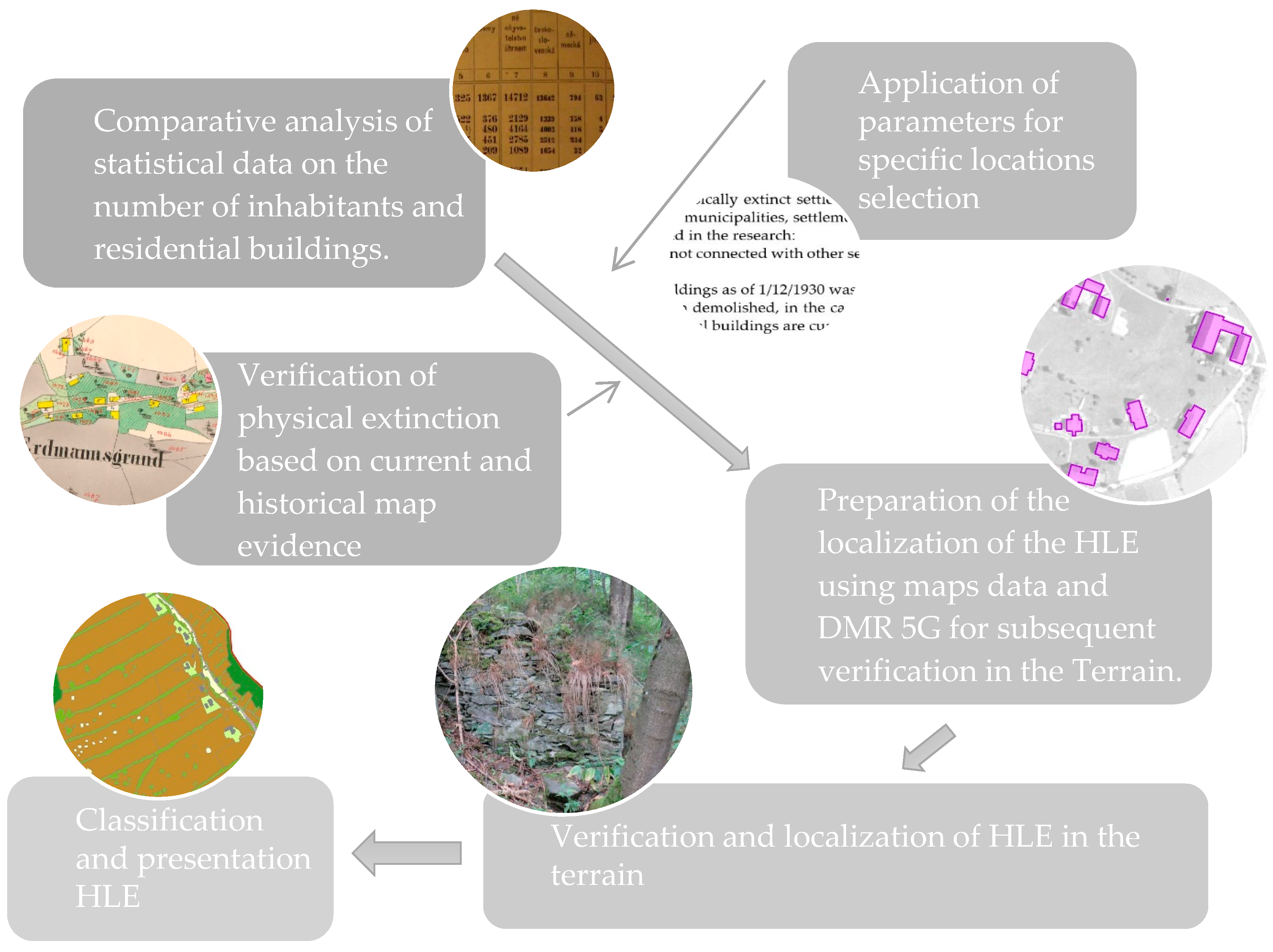
  • A methodical procedure for identifying defunct settlements on the basis of historical and contemporary sources (registers, maps, and photo documentation, including field surveys); part of this procedure is the mapping of historical landscape elements (relics of the original settlement).
  • The variability of historical landscape elements on the territory of selected extinct settlements, to carry out their classification and evaluate their development in the context of changes in anthropic pressure between the years 1945 and 2022.
  • Trends in landscape structure dynamics after changes in anthropogenic pressure in relation to the current state of the landscape and preserved historical relics.
  • An answer to the question whether the cause of the settlement’s demise affects the number of preserved HLEs.
It is necessary to admit that the presented methodology only partially affects changes in the landscape structure in the described context—in the peripheral and higher-attitude areas, it is possible to find other localities affected by changes in anthropic pressure (associated with the partial departure of people). Because these localities are still partially inhabited, they were not included in the research. However, they certainly represent potential for the use of the methodology in the future (especially in terms of relics of the original settlement). On the basis of the study of existing research studies, a case study area was selected that had not been elaborated overall and a large number of locations with diverse landscape structure and causes of extinction could be detected.

2. Materials and Methods

2.1. Study Area

The state and development of historical landscape elements was evaluated in the territory of the Moravian-Silesian Region, which was a historical self-governing unit of the Czechoslovak Republic. For the basic output, a shape file was created in ArcGIS Pro software with a border corresponding to the Moravian-Silesian Region, which was created in 1928 and existed until 1948 (Figure 1). The localization and the evaluation of the classification and changes of the HLEs were carried out at specified locations of physically extinct settlements that disappeared in the period 1945–2020.

2.2. Data Collection—Identifying Extinct Settlements

The identification of localities was first carried out on the basis of the evaluation of demographic data of individual settlements. A comparative analysis of statistical data on the number of inhabitants and residential buildings before the Word War II and the present was used. The starting point for the comparison, for the selected period (1945–2020), was the data of the Statistical Lexicon of Municipalities in the Czechoslovak Republic (based on the census of 1 December 1930, which was published between 1934 and 1937, while in the case of the territories of Moravia and Silesia, the second part of the lexicon for the Moravian-Silesian country was used) [27]. Data from the German census from 1939 were not taken into account, as this census did not cover the entire territory of today’s Czech Republic (nor some areas of the Czech border that were not taken over by Germany in 1938) and can therefore be considered as only an additional source [28]. It is also not recommended to use data on the number of inhabitants from 1950, which already reflected the changes associated with the post-WWII expulsion. The Historical Lexicon of Municipalities of the Czech Republic 1869–2011 published by the Czech Statistical Office can be used as a supporting source for data completion [29]. As part of the search and examination of affected settlements, demographically positive localities were first identified, which are those localities in the period in which the following was observed:
  • There was a drop in the permanent resident population by more than 95%.
  • At the same time, the municipality, settlement, or local part (without registration or because of a marked decrease in permanent residents) was administratively merged with a different seat.
The physical extinction was subsequently verified by using the reconnaissance of the current map documents of the basic map (ZM10) and the current orthophoto map, as well as historical map documents, such as military topographical maps in the S-1952 system (1951–1971) and imperial mandatory imprints of the stable cadaster (1824–1843), original stable cadaster maps (1824–1843), or indicative sketches derived from them or land cadaster maps (1926–1956). All map sources used can be obtained from the website https://ags.cuzk.cz/archiv/ (accessed on 10 November 2022). These websites (free of charge) are provided by the Czech Office for Surveying, Mapping, and Cadastre.
Because of the considerable extent of physically extinct settlements, especially various hamlets with their own local names, only municipalities, settlements, and local parts that met the following other parameters were included in the research:
  • The settlement structure was not connected with other settlements in village or settlement planning.
  • The number of residential buildings as of 1 December 1930 was more than 5.
  • Most of the buildings had been demolished; in the case of larger settlements, no more than 5 original residential buildings are currently preserved.

2.3. Data Collection—Identification and Classification of Historical Landscape Elements and Trends of Landscape Structure Change

At each location of a physically extinct settlement, preserved HLEs were mapped. These elements can be defined as delimited formations or their groups, which were demonstrably established in the landscape in connection with a previous settlement and can be identified on current and historical map data. An element is preserved if it was possible to identify any sign demonstrably related to the original structure in the field or based on current map data, especially a digital model of the relief (the degree of preservation was not evaluated). For the localization of historical landscape elements, the method of comparing historical and current map data, mainly aerial surveying images (hereinafter referred to as ASI) starting from 1936 and orthophoto maps, was used. The analysis of map data was supplemented by terrain reconnaissance in the years 2019 to 2022. It is advisable to carry out the field survey in a period of dormant vegetation with no snow cover, to aid movement in the terrain, enabling better visibility and localization of landscape elements. Prospective locations can be preselected for wooded locations with the occurrence of historical landscape elements on the basis of the data on the digital relief model of the Czech Republic 5th generation (DMR 5G) and to delineate these localities for detailed investigation in current and historical map documents and subsequently in the field. As part of the field survey, determining the exact localization of historical landscape elements with monument potential was carried out.

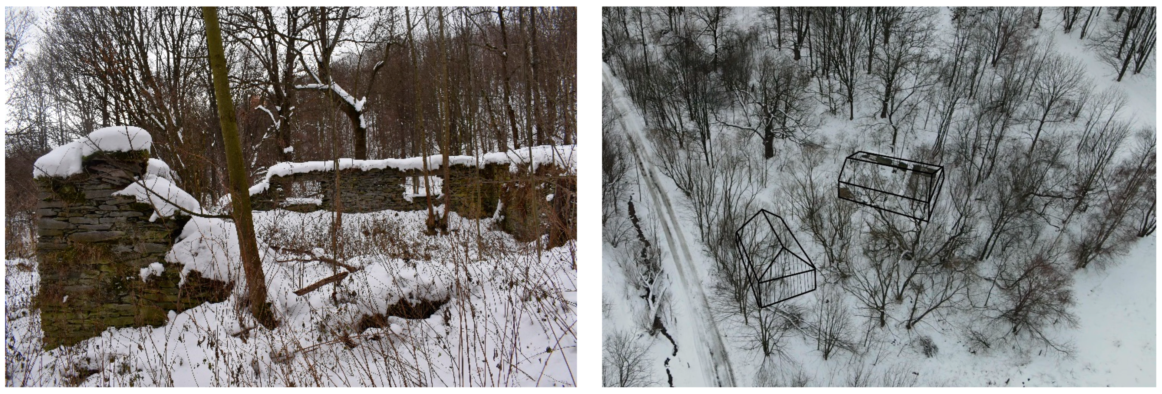
2.3.1. Classification of Historical Landscape Elements

An overview of the mapped HLEs is shown in Table 1. The research did not include elements such as the road network, the size and shape of the land, or the change in the agricultural land fund, and this is due to the development of the cultural landscape associated with the collectivization of agriculture throughout the territory of former Czechoslovakia, especially from the 1960s. Furthermore, wetlands that cannot be accurately located based on the ASI, even because of the earlier economic use of wetlands, were not included.
For each locality, a record of preserved landscape elements classified according to the abovementioned groups was processed, including quantitative representations. The records also contain an evaluation of the long-term trend in the development of the landscape structure and the determination of anthropogenic influences. Correlations were found between the cause of extinction while accounting for anthropogenic influences and the group of preserved elements and their abundance.

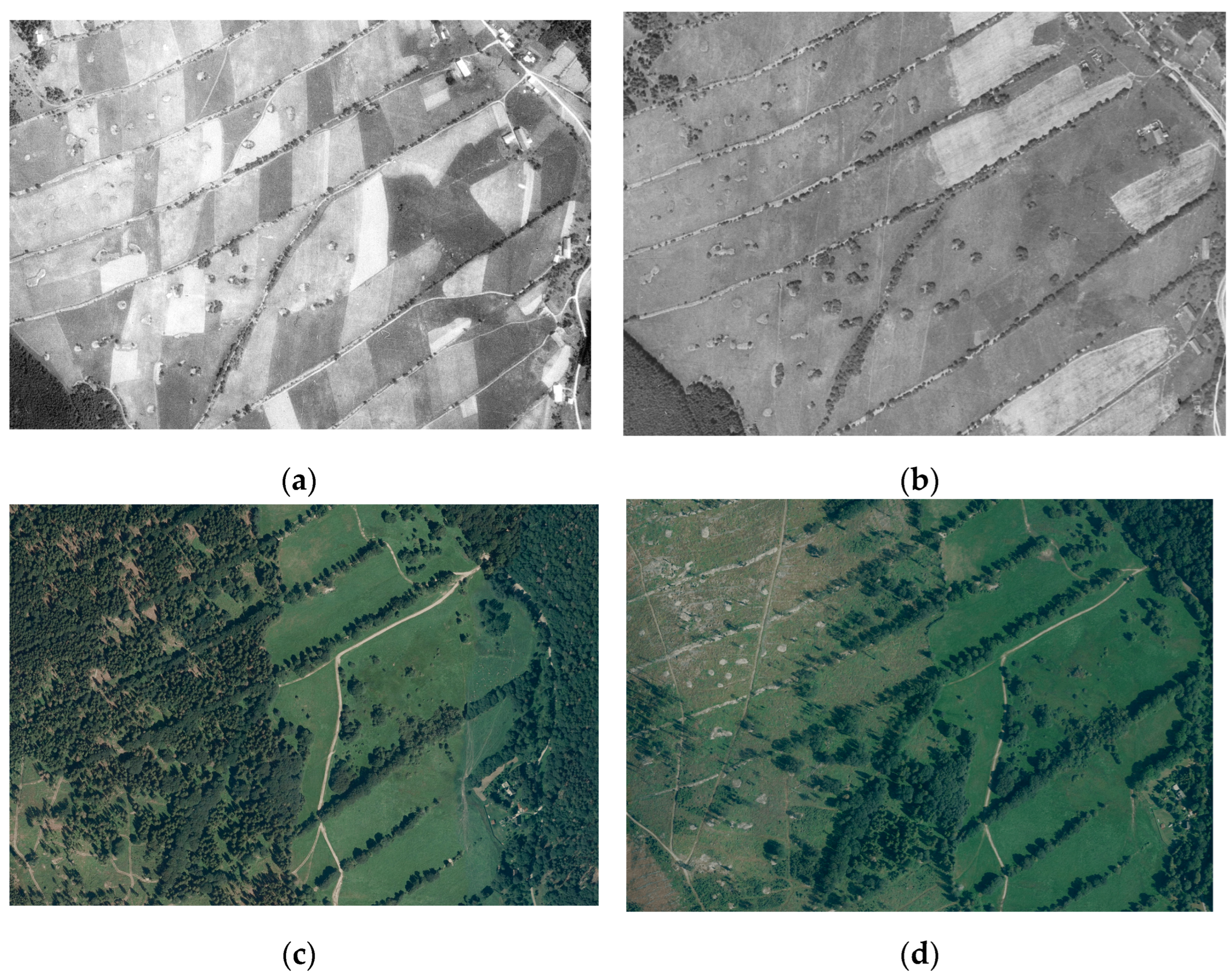
2.3.2. Classification of Trends in Landscape Structure Change

Within the research survey and the analysis of ASI, it was possible to distinguish landscape structure changes. Almost all sites were economically exploited. The change in landscape texture is very pronounced in the monitored sites. The reason for this change is the consolidation of agricultural land funds (hereinafter referred to as ALFs) and intensive forestry [12].
For individual localities of extinct settlements, a basic trend of landscape structure change was identified, which can be divided into 4 groups with an indication of the prevailing character of extinct settlements:
  • Afforestation of ALF.
  • Transformation of the ALF structure with or without a small number of preserved HLEs not referring to the historical landscape structure.
  • Transformation of the ALF structure with a high number of preserved HLEs, referring to the historical landscape structure (the basic skeleton of the original landscape structures was preserved).
  • Complete change of land use (construction, flooding, mining expansion, etc.).
For a better understanding of the methodology, including the continuity of the individual steps, see Figure 2.
For recording elements, image documentation was taken, and in the case of hard-to-reach locations or in the case of excessively large elements, drone images were taken. The visual outputs then serve as the basis for the descriptive textual part and for the presentation of landscape elements, such as for educational activities, or as a visual basis for 3D models and printing (Figure 3), augmented (extended) reality, learning trails, or short audiovisual documents.

3. Results

3.1. Territorial Dispersion of Extinct Settlements, including the Cause of Extinction

A total of 105 settlements were located on the territory of Moravia and Silesia (Figure 4). Dozens of other settlements were identified outside the research locations, where there was a nonphysical extinction or where the settlement did not meet one of the abovementioned subconditions (these localities were not included in the database).
The largest concentration of extinct settlements is in the northern part of the model area, with a total of 52 locations (specifically, 14 settlements in the Jeseník district, 17 settlements in Šumperk district, and 21 settlements in the Bruntál district). The dominant factor in the extinction here was the expulsion of the German population after 1945 and subsequent nonsettlement. In several cases, this area is combined with the proximity of the state border and the declaration of a prohibited border zone. Two residences were flooded in a water reservoir (hereinafter referred to as WR).
The second area with a high concentration of physically extinct settlements is the military training area Libavá in the Olomouc district (26 settlements), where there was a combination of the displacement of residents after 1945 and the creation of a military training area.
The remaining part of the territory of Moravia and Silesia (27 localized extinct settlements) is considerably diversified in terms of the area of dispersion and the cause of extinction. These are rather isolated localities, rather than a more integrated area. The demise of the settlement here is connected mainly with the construction of infrastructure (a nuclear power plant, water reservoirs, protection of drinking water sources) and mining, while in three cases the settlement disappeared because of the proximity of the state border (again with a combination of the expulsion of residents after 1945).

3.2. Specific Features of Areas according to the Cause of Extinction and Current Use

The most frequently identified data associated with the disappearance of settlements is the cause of the extinction. The results indicate that there is a link between the cause of settlement extinction and the surviving HLE groups. An example is the preserved agrarian stone mounds (Figure 5) in locations of extensive agriculture. In the study area, six causes of the physical disappearance of settlements were identified (Figure 4): expulsion of German inhabitants and nonsettlement, proximity to the state border, the establishment of a military training area, the construction of a water reservoir, the development of mining, and the construction of other development projects (e.g., nuclear power plant, airport). For the purpose of the research, the settlements were grouped into four groups: Group 1 includes expulsion of German residents and proximity to the state border (53 locations); Group 2 includes the military training area Libavá (26 locations); Group 3 includes the water reservoirs (17 locations); and Group 4 includes mining and development projects (9 locations).

3.2.1. Group 1: Expulsion of German Inhabitants and Nonsettlement of the Area with a Combination of Location near the State Border

Locations falling into this category can be divided into two subgroups from the point of view of physical-geographical assumptions and the current method of use. The first are the localities of flat and hilly areas, with a lower altitude and with a higher potential of quality soils and climatic conditions for agriculture. The most common in these settlements is the transformation of the landscape structure and ALF with or without a small number of preserved HLEs.
In this group, nonforest woody vegetation had already been represented in a small amount and extent before 1945; there was no expansion of it, only partial preservation. Most often, the built-up areas were overgrown with ruminant vegetation, and the torsos of buildings were preserved, especially large- and small-scale sacral monuments and cemeteries. More-significant demolition took place mainly in the vicinity of state borders. In several of these localities, paved historical roads and accompanying elements (bollards, bridges and their foundations, avenues, rows of trees, and orchards) have been preserved. Agrarian stone walls and ramparts are not represented in the landscape.
The level of demolition and drainage of wet areas, together with agricultural use of the landscape and nonexpansion of forest areas, had the greatest influence on the preservation of the historical landscape structure and its elements.
The second group includes settlements located in valleys and on slopes in the High Ash Mountains and Golden Mountains. Nonforest woody vegetation and land barriers (terracing, agrarian mounds, and heaps) were significantly represented here, and a relatively clearly separated structure of the fallow land can be identified here. In these settlements, the transformation of the ALF structure with a high number of preserved HLEs, referring to the historical landscape structure, occurred most often. In the Šumperk district, afforestation of ALF occurred more often.
The most important element of these settlements is agrarian stone walls and ramparts. Areas of nonforest woody vegetation have expanded. Al agricultural areas serve as permanent grass cover. The demolitions in these locations were mostly not thorough, and it is possible to find the torso of the buildings (Figure 6). Because of the climatic conditions, there are usually no fruit trees on the territory. Anthropogenic influences were afforestation, demolition (mostly of sacred monuments), grassing over all agricultural areas, and extensive agriculture. Near several physically extinct settlements, it is possible to find historical landscape elements associated with the mining of ores and slate, namely entrances to tunnels and heaps.

3.2.2. Group 2: Military Training Area Libavá

Like the case of settlements in Bruntál, Jeseník, and Šumperk districts, the villages of Libavá can be divided according to climatic and geographical conditions into settlements that were located in the steep valleys of the Oder Highlands and settlements in the southern part of the military training area Libavá, where the transformation into hilly to flat areas took place.
In most of the localized settlements, the structure of the ALF has been transformed with no or a small number of preserved HLEs. If the historical landscape structures have been preserved, they are very difficult to read (agricultural areas are used monofunctionally and are connected to the surrounding forests). Forests are not clearly separated by a sharp boundary from the surrounding herbaceous communities with a sparsely overgrown shrub and tree layer of hawthorns and birches and ruminant woody vegetation.
The most important anthropogenic factor affecting the development of landscape features is the use of land for military purposes. Most of the original built-up areas are overgrown with rubble site vegetation, which is related to the disappearance of the original fruit trees. In most cases, complete demolition did not take place, and it is, therefore, possible to find torsos and ruins of buildings. In the territory of the military training area Libavá, there are, with exceptions, sacred monuments of a larger scale (churches, chapels) and cemeteries only in the form of ruins and torsos (Figure 7).
Elements of paved historical roads and stone bridges are exceptionally preserved—bollards. Walls can also be found along waterways. A significant element is the remains of slate mining. In several cases, it is possible to locate historical avenues and rows of trees. A limited number of nonforest woody vegetation, terraces, agrarian walls, and ramparts have been preserved in the area, mainly at settlements that were in deeper valleys with a significant slope of agricultural areas. Groups of HLEs were preserved mainly outside the active areas of training grounds, shooting ranges, landing sites, and associated buildings, including built-up water reservoirs, which, among other things, were for firefighting.

3.2.3. Group 3: Water Reservoirs

Locations with the reason for the demise connected with the construction of water reservoirs, whether located below the water level or associated with demolition within the protection zones at WR Kružberk, WR Vír, WR Šance, WR Nové Mlýny, WR Letovice, and WR Slezská Harta, are associated with a complete change in land use and therefore changes in the landscape structure. In this landscape, there is an absence of historical landscape elements, or they are exceptionally preserved and represented in individual elements. The exception is the defunct settlements around the Kružberk water reservoir, where the settlements did not disappear when the water reservoir was built, but only after the water reservoir was reassigned as a source of drinking water.

3.2.4. Group 4: Development Projects, Landscape Exploitation, and Mining

Localities that disappeared in connection with development projects have relatively few preserved landscape elements, because of the complete change of the landscape structure and use of the landscape. It is not possible to determine groups of preserved HLEs for this category of settlements. Unlike water reservoirs, there is no monofunctional anthropological influence here but rather a combination of demolition, construction, mining, reclamation, and economic use of the landscape. The transformation of the ALF structure occurred with or without a small number of surviving HLEs.
An overview of the groups of HLEs and the anthropogenic influences that primarily influenced their preservation, regardless of the climatic-geographical macro and micro conditions of the given locations, is shown in Figure 8.

3.3. Classification of Historical Landscape Elements according to Selected Criteria

The division of settlements into groups according to the basic change of the landscape structure is as follows:
  • Afforestation of ALF: the 12 settlements are mostly settlements that disappeared in connection with the expulsion of the original Germans residents, located in higher positions and characterized by steep slopes.
  • The transformation of the ALF structure with or without a small number of preserved HLEs not referring to the historical landscape structure: the 52 settlements are mostly those that disappeared in connection with the expulsion of the original German population located in lowland areas (the intensive agricultural use of the territory is symptomatic) and localities in protective zones.
  • The transformation of the ALF structure with a high number of preserved HLEs, referring to the historical landscape structure: the 15 settlements are mostly those that disappeared in connection with the expulsion of the original population, located in higher elevations, currently used as pastures and mowed meadows.
  • Complete change of land use: the 26 settlements are those affected by the mining and the construction of development projects and water reservoirs.
Except for the last group (a complete change of territory), historical landscape elements were preserved in all types of territories. The best-preserved landscape elements with the greatest variability can be found in locations currently used as permanent grasslands (meadows or pastures). The targeted afforestation of the site also created suitable conditions for the conservation of HLEs [12].
Table 2 summarizes the frequency of elements in HLE groups (divided into intervals), on the number of locations divided into the cause of the settlement’s extinction.
The HLEs in Group 1 represent the highest frequency and variability (have been detected at most locations). The exceptions are only building ruins and monuments, cellars and wells, and partially historical floor plans of extinct churches and chapels, the torso of cemeteries, and sacral and other small building monuments, which are most frequent in Group 2. HLEs in Groups 3 and 4 are significantly affected by landscape exploitation. Locations in these groups are thus less attractive for the documentation and presentation of HLEs. Settlements in Groups 3 and 4 are also most often represented in the trend of complete land-use change.

4. Discussion

In connection with the long-term influence of humans on the landscape, seminatural biotopes prevail across the European area. Although anthropogenic pressure reshapes the landscape and disrupts its stability, it can simultaneously promote diversity in the landscape at the landscape and species levels [30,31,32,33]. Historical landscape elements play an important role in this regard. Landscape elements can serve as indicators of landscape cultural heritage [34]. According to Speed et al. [35], it is necessary to take these values into account when valuing the landscape and developing care plans. HLEs can also be a source of support for decentralized tourism as support for socioeconomic pillars of sustainable development and cognitive functions in society. Landscape elements and other carriers of ecological memory significantly influence the visual perception of the landscape and genius loci [36].
The assessment of the development of the landscape structure over time and the projection of knowledge in the current planning of the restoration of the territory with an emphasis on ecosystem services are also emphasized by other authors (e.g., [37,38]). There is a backtrack from research on quantitative changes in land use categories, or CORINE Land Cover [39,40,41]. Delgado-Serrano and Hurtado-Martos [42] replace quantitative research on land use an interdisciplinary qualitative analysis of relationships and ties in the territory based on knowledge of the local environment. It is also important to take into account the historical contexts that have shaped the landscape for a long time (e.g., [43,44]). In this direction, it is necessary to supplement factual historical events, including political decisions, with the so-called memory of the landscape, which can be recorded through interviews with witnesses [45]. However, the participation of citizens plays an important role not only in the sense of memories of the landscape [46] but also in planning its future use on the basis of the requirements of local actors (current users of the territory). Interest in the landscape and its changes (including the preservation of values) can be supported by an approach called contemporary memorial landscape/CML [47], which does not need to point only to architectural and cultural monuments, for which societal consensus can be assumed on their formal protection. Other elements (e.g., agrarian ramparts and walls, original varieties of fruit trees) can also be designated as having landscape value. Antrop [48] points to the fact that small compositional elements in the wider spatial context of the landscape are important for its division and creation of local identity and overall value. In recent years, the heterogeneity of the landscape has been considered part of the prevention of environmental risks (drought, fires, etc. [49]). The question of reusing the land for its original purpose (especially for growing agricultural crops) and for the current challenges associated with global changes is also promising [50,51].
This interdisciplinary approach provides a broader focus for landscape analysis, without being limited to the quantitative dimension, and includes a wider range of relationships in the landscape system [52]. The research followed on from the study of historical landscape structures and related changes and their driving forces [53,54,55,56]. The results of this research confirmed that the historical maps have improved the representation of changes in the landscape structure [57]; that it is appropriate to use visual historical documents for the research of landscape changes [58]; and that the major trend is the homogenization of abandoned space [59]. The changes in the landscape were thus intensified not only by a significant decrease in population but also by economic and political changes after 1948 [60]. The topic of landscape change and landscape extinction (in the sense of being overwritten by another land use) in Czechia is addressed by a number of authors, such as Jelen and Čabelka [61]. Their research is part of the Extinct Landscapes project, which focuses on indexing landscape change. The landscape change index refers to the basic groups of landscape changes in our results. Another methodology may be based on the identification of cultural, historical and aesthetic values of the landscape. The identification of landscape values was the starting point for the determination and localization of HLEs. The uniqueness of our approach lies in the clear definition of the methodology for identifying physically extinct settlements and other classification groups: classes of landscape structure development and groups of historical landscape elements. The methodology combines individual, previous partial-historical, sociological, and landscape studies—such a methodology has not yet been applied in this way.

5. Conclusions

The topic of defunct settlements was primarily the domain of social sciences. In the disappearance of settlements throughout the territory of Czechia, in the period of modern history, the most affected was the disappearance associated with removal after 1945. The content of the contribution presented the variability of the monitored groups of HLEs, and on the basis of the methodology, the study carried out a classification and evaluated the development in the context of anthropic pressure in the period 1945–2022. A database of 105 landscapes of physically extinct settlements in the territory of Moravia and Silesia was compiled. Research has confirmed a link between the cause of the seat’s demise: Group 1—the expulsion of German residents and proximity to the state border (53 locations); Group 2—military training area Libavá (26 locations); Group 3—water reservoirs (17 locations); Group 4—mining and development projects (9 locations); and surviving HLE groups. It presented the causality of anthropogenic pressure and the preservation of HLEs. Steep slopes and less-fertile soil are typical of agrarian stone walls, ramparts, and terraces. The current land use is dominantly pasture and mowed meadows, or possibly forest stands. For old fruit trees, orchards, and avenues, rows of trees are typical lower elevations and locations close to the road network, and the current land use is dominantly pasture and mowed meadows, or possibly forest stands. The group of nonforest woody vegetation is symptomatic of localities with higher elevations and sloping land (and the gradual extensification of agriculture); typically, the current land use is dominantly pasture and mowed meadows. Abandoned historical quarries of ores, rocks, and minerals are preserved because of a specific combination of agricultural and forestry farming and dedicated handling areas for heavy equipment. Paved historic roads, stone bridges, and bollards are less-frequent elements, surviving mainly in forest cover (bollards, typical routing of access roads, bridges) or in visually open locations (original stone paved roads). All groups of building monuments are typical of less-accessible sites with limited agricultural use. Furthermore, the study identified and evaluated the basic trend of landscape structure change: afforestation ALF (12 seats); the transformation of the ALF structure with or without a small number of preserved HLEs, not referring to the historical landscape structure (52 seats); the transformation of the ALF structure with a high number of preserved HLEs, referring to the historical landscape structure (15 seats); and a complete change of land use (26 seats).
Thanks to the methodology, the research can be extended to the database of human settlements on a smaller scale (under five residential houses), to other areas of Czechia and the world or even to other time periods. After adjusting for regional and historical peculiarities, the methodology can serve as a basis for other world landscapes. The obtained outputs are a suitable basis not only for landscape planning but also for supporting the decentralization of tourism and supporting the pillars of sustainable development. They can also serve to educate the general public.

Author Contributions

Conceptualization, V.P.; methodology, V.P. and H.V.; data collection, V.P. and D.K.; validation, V.P., H.V. and T.M.; formal analysis, V.P.; resources, V.P. and D.K.; data curation, V.P.; writing—original draft preparation, V.P.; writing—review and editing, V.P., H.V., D.K., T.M., A.V. and M.Š.; visualization, V.P.; supervision, A.V.; project administration, H.V.; funding acquisition, H.V. and M.Š. All authors have read and agreed to the published version of the manuscript.

Funding

This research was funded by the Ministry of Culture of the Czech Republic, grant number DG18P02OVV070. And The APC was funded by the Department of Applied and Landscape Ecology, Faculty of AgriSciences at the Mendel University in Brno.

Acknowledgments

This paper is the output of the project “Identification and permanent documentation of cultural landscape and settlement memory: case study of abandoned settlements of Moravia and Silesia” (DG18P02OVV070), supported by the Ministry of Culture, Czech Republic (within the program NAKI II)—along with the specific research at the Department of Applied and Landscape Ecology, Faculty of AgriSciences at the Mendel University in Brno.

Conflicts of Interest

The authors declare no conflict of interest.

References

  1. McLeman, R.A. Settlement abandonment in the context of global environmental change. Glob. Environ. Chang. 2011, 21, 108–120. [Google Scholar] [CrossRef]
  2. Yang, L.; Long, H.; Cheng, H.; Hu, G.; Duan, H.; Zhao, H. Historical settlement abandonment in the middle Hexi Corridor linked to human-induced desertification. Palaeogeogr. Palaeoclimatol. Palaeoecol. 2020, 545, 109634. [Google Scholar] [CrossRef]
  3. Pechtl, J. Constant change of LBK settlement in the upper Danube region. Quat. Int. 2020, 560–561, 240–247. [Google Scholar] [CrossRef]
  4. Ritchison, B.T. Investigating 14th century immigration and settlement response on the Georgia Coast, USA. J. Archaeol. Sci. Rep. 2018, 21, 606–618. [Google Scholar] [CrossRef]
  5. Abel, G.J.; Brottrager, M.; Cuaresma, J.C.; Muttarak, R. Climate, conflict and forced migration. Glob. Environ. Chang. 2019, 54, 239–249. [Google Scholar] [CrossRef]
  6. Konoplev, A.; Kato, K.; Kalmykov, S.N. (Eds.) Behaviour of Radionuclides in the Environment II. Chernobyl; Springer: Singapore, 2020; 443p. [Google Scholar] [CrossRef]
  7. Bičík, I.; Jeleček, L.; Štěpánek, V. Land-use changes and their social driving forces in Czechia in the 19th and 20th centuries. Land Use Policy 2001, 18, 65–73. [Google Scholar] [CrossRef]
  8. Vaishar, A.; Vavrouchová, H.; Lešková, A.; Peřinková, V. Depopulation and Extinction of Villages in Moravia and the Czech Part of Silesia since World War II. Land 2021, 10, 333. [Google Scholar] [CrossRef]
  9. Mares, P.; Rasin, R.; Pipan, P. Abandoned Landscapes of Former German Settlement in the Czech Republic and in Slovenia. Cultural Severance and the Environment. Environ. Hist. 2013, 2, 289–309. [Google Scholar] [CrossRef]
  10. Guzi, M.; Huber, P.; Mikula, Š. The long-term impact of the resettlements of the Sudetenland on residential migration. J. Urban Econ. 2021, 126, 103385. [Google Scholar] [CrossRef]
  11. Skokanová, H.; Faltan, V.; Havlicek, M. Driving forces of main landscape change proceses from past 200 years in Central Europe—Differences between old de mocratic and post-socialist countries. Ekol. Bratisl. 2016, 35, 50–65. [Google Scholar] [CrossRef] [Green Version]
  12. Vavrouchová, H.; Vaishar, A.; Peřinková, V. Historical Landscape Elements of Abandoned Foothill Villages—A Case Study of the Historical Territory of Moravia and Silesia. Land 2022, 11, 1809. [Google Scholar] [CrossRef]
  13. Fanta, V.; Beneš, J.; Zouhar, J.; Rakava, V.; Šitnerová, I.; Janečková Molnarová, K.; Šmejda, L.; Sklenička, P. Ecological and historical factors behind the spatial structure of the historical field patterns in the Czech Republic. Sci. Rep. 2022, 12, 8645. [Google Scholar] [CrossRef] [PubMed]
  14. Bastian, O.; Walz, U.; Decker, A. Historical landscape elements: Part of our cultural heritage—A methodological study from Saxony. In The Carpathians: Integrating Nature and Society towards Sustainability; Springer: Berlin/Heidelberg, Germany, 2013; pp. 441–459. [Google Scholar] [CrossRef]
  15. Scherreiks, P.; Gossner, M.M.; Ambarlı, D.; Ayasse, M.; Blüthgen, N.; Fischer, M.; Klaus, V.H.; Kleinebecker, T.; Neff, F.; Prati, D.; et al. Present and historical landscape structure shapes current species richness in Central European grasslands. Landsc. Ecol. 2022, 37, 745–762. [Google Scholar] [CrossRef]
  16. Kučera, P.; Novák, J.; Löw, J.; Dohnal, T. Historical Landscape Structures and Their Importance for Landscape Character. Acta Univ. Agric. Silvic. Mendel. Brun. 2015, 63, 49–57. [Google Scholar] [CrossRef] [Green Version]
  17. Xu, W. Ecological Integrity Evaluation of Organically Evolved Cultural Landscape. Mob. Inf. Syst. 2022, 2022, 9554359. [Google Scholar] [CrossRef]
  18. Zímová, K.; Pospíšil, L.; Janovská, V.; Karlík, P.; Houfková, P.; Bumerl, J.; Molnárová, K.; Beneš, J.; Bernardová, A. Pluzina development analysis of an abolished village Malonín in Prachatice region. Acta Pruhoniciana 2013, 104, 27–37. [Google Scholar]
  19. Affek, A.N.; Wolski, J.; Latocha, A.; Zachwatowicz, M.; Wieczorek, M. The use of LiDAR in reconstructing the pre-World War II landscapes of abandoned mountain villages in southern Poland. Archaeol. Prospect. 2021, 29, 157–173. [Google Scholar] [CrossRef]
  20. Pérez-Espona, S.; Pérez-Barbería, F.J.; McLeod, J.E.; Jiggins, C.D.; Gordon, I.J.; Pemberton, J.M. Landscape features affect gene flow of Scottish Highland red deer (Cervus elaphus). Mol. Ecol. 2018, 17, 981–996. [Google Scholar] [CrossRef]
  21. Dupont, L.; Torres-Leguizamon, M.; René-Corail, P.; Mathieu, J. Landscape features impact connectivity between soil populations: A comparative study of gene flow in earthworms. Mol. Ecol. 2017, 26, 3128–3140. [Google Scholar] [CrossRef]
  22. Kolejka, J.; Krejčí, T.; Nováková, E. The Pre-industrial landscape in Moravia. The case study of inventory and analysis of the ancient land use structures in the Czech Republic). Land Use Policy 2020, 97, 104712. [Google Scholar] [CrossRef]
  23. Vollmer, D.; Prescott, M.F.; Padawangi, R.; Girot, C.; Grêt-Regamey, A. Understanding the value of urban riparian corridors: Considerations in planning for cultural services along an Indonesian river. Landsc. Urban Plan. 2015, 138, 144–154. [Google Scholar] [CrossRef]
  24. Stundžienė, B. Lithuanian Cultural Landscape in Folklore from the Perspective of Values. Vilnius Univ. Open Ser. 2020, 2020, 81–101. [Google Scholar] [CrossRef]
  25. Pan, Y.; Hersperger, A.M.; Kienast, F.; Liao, Z.; Ge, G.; Nobis, M.P. Spatial and temporal scales of landscape structure affect the biodiversity-landscape relationship across ecologically distinct species groups. Landsc. Ecol. 2022, 37, 2311–2325. [Google Scholar] [CrossRef]
  26. Špulerová, J.; Izakovičová, Z.; Vlachovičová, M.; Černecký, J. Natural or Semi-natural Landscape Features as Indicator of Biocultural Value: Observations from Slovakia. Hum. Ecol. 2022, 50, 531–543. [Google Scholar] [CrossRef]
  27. Boháč, A.; Prokop, L. Statistical Lexicon of Municipalities in the Czechoslovak Republic: Official List of Places According to the Law of April 14, 1920, no. 266 Coll. Disciple. and Birth Order; Orbis: Prague, Czech Republic, 1935. [Google Scholar]
  28. Vaishar, A.; Dvořák, P.; Zapletalová, J. The forgotten Census 1939 in the Czech borderland. Inf. Czech Geogr. Soc. 2019, 38, 1–9. [Google Scholar]
  29. Růžková, J.; Škrabal, J. Historical Lexicon of Municipalities of the Czech Republic 1869–2005. Part I. Number Inhabitants and Houses by Municipalities and Parts of Municipalities in the Years 1869–2001 According to the Administrative Division of the Czech Republic as of January 1; Czech Statistical Office: Prague, Czech Republic, 2005. [Google Scholar]
  30. Capolupo, A.; Kooistra, L.; Boccia, L. A novel approach for detecting agricultural terraced landscapes from historical and contemporaneous photogrammetric aerial photos. Int. J. Appl. Earth Obs. Geoinf. 2018, 73, 800–810. [Google Scholar] [CrossRef]
  31. Szilassi, P.; Gallé, T.; Szép, T.; Csikós, N. Scale dependence of landscape-structure-based estimation of abundance of Eurasian skylark (Alauda arvensis). Ecol. Indic. 2022, 139, 108931. [Google Scholar] [CrossRef]
  32. Woodcock, B.A.; Pywell, R.F.; Macgregor, N.A.; Edwards, M.E.; Redhead, J.; Ridding, L.E.; Batáry, P.; Czerwiński, M.; Duffield, S. Historical, local and landscape factors determine the success of grassland restoration for arthropods. Agric. Ecosyst. Environ. 2021, 308, 10727. [Google Scholar] [CrossRef]
  33. Walz, U. Landscape Structure, Landscape Metrics and Biodiversity. Living Rev. Landsc. Res. 2011, 5, 3. [Google Scholar] [CrossRef]
  34. Stanik, N.; Aalders, I.; Miller, D. Towards an indicator-based assessment of cultural heritage as a cultural ecosystem service—A case study of Scottish landscapes. Ecol. Indic. 2018, 95, 288–297. [Google Scholar] [CrossRef]
  35. Speed, J.D.M.; Austrheim, G.; Birks, H.J.B.; Johnson, S.; Kvamme, M.; Nagy, L.; Sjögren, P.; Skar, B.; Stone, D.; Svensson, E.; et al. Natural and cultural heritage in mountain landscapes: Towards an integrated valuation. Int. J. Biodivers. Sci. Ecosyst. Serv. Manag. 2012, 8, 313–320. [Google Scholar] [CrossRef] [Green Version]
  36. Andersson, E.; Barthel, S. Memory carriers and stewardship of metropolitan landscapes. Ecol. Indic. 2016, 70, 606–614. [Google Scholar] [CrossRef]
  37. Picuno, P.; Cillis, G.; Statuto, D. Investigating the time evolution of a rural landscape: How historical maps may provide environmental information when processed using a GIS. Ecol. Eng. 2019, 139, 105580. [Google Scholar] [CrossRef]
  38. Tortora, A.; Statuto, D.; Picuno, P. Rural landscape planning through spatial modelling and image processing of historical maps. Land Use Policy 2015, 42, 71–82. [Google Scholar] [CrossRef]
  39. Li, Q.; Jin, T.; Peng, Q.; Lin, J.; Zhang, D.; Huang, J.; Liu, B. Identifying the extent of the spatial expression of landscape fragmentation based on scale effect analysis in Southwest China. Ecol. Indic. 2022, 141, 109120. [Google Scholar] [CrossRef]
  40. Nguyen Tran, T. Urbanization and land use change: A study in Vietnam. Environ. Socio Econ. Stud. 2022, 10, 19–29. [Google Scholar] [CrossRef]
  41. Juknelienė, D.; Kazanavičiūtė, V.; Valčiukienė, J.; Atkocevičienė, V.; Mozgeris, G. Spatiotemporal Patterns of Land-Use Changes in Lithuania. Land 2021, 10, 619. [Google Scholar] [CrossRef]
  42. Delgado-Serrano, M.M.; Hurtado-Martos, J.A. Land Use Changes in Spain. Drivers and Trends in Agricultural Land Use. EU Agrar. Law 2018, 7, 1–8. [Google Scholar] [CrossRef] [Green Version]
  43. Phillips, J.D. 7—Thresholds, tipping points, and instability. In Landscape Evolution, Landforms, Ecosystem, and Soils; Elsevier: Amsterdam, The Netherlands, 2021; 342p. [Google Scholar] [CrossRef]
  44. Związek, T.; Panecki, T.; Zachara, T. A retrogressive approach to reconstructing the sixteenth-century forest landscapes of western Poland. J. Hist. Geogr. 2021, 74, 55–74. [Google Scholar] [CrossRef]
  45. Paniagua, A. Old, Lost, and Forgotten Rural Materialities: Old Local Irrigation Channels and Lost Local Walking Trails. Land 2022, 11, 1358. [Google Scholar] [CrossRef]
  46. Wheeler, R. Mining memories in a rural community: Landscape, temporality and place identity. J. Rural Stud. 2014, 36, 22–32. [Google Scholar] [CrossRef]
  47. Attwa, Y.; Refaat, M.; Kandil, Y. A study of the relationship between contemporary memorial landscape and user perception. Ain Shams Eng. J. 2022, 13, 101527. [Google Scholar] [CrossRef]
  48. Antrop, M. Why landscapes of the past are important for the future. Landsc. Urban Plan. 2005, 70, 21–34. [Google Scholar] [CrossRef]
  49. Lasanta, T.; Cortijos-López, M.; Paz Errea, M.; Khorchani, P.M.; Nadal-Romero, E. An environmental management experience to control wildfires in the mid-mountain mediterranean area: Shrub clearing to generate mosaic landscapes. Land Use Policy 2022, 118, 106147. [Google Scholar] [CrossRef]
  50. Fayet, C.M.J.; Reilly, K.H.; Van Ham, C.; Verburg, H.P. What is the future of abandoned agricultural lands? A systematic review of alternative trajectories in Europe. Land Use Policy 2022, 112, 105833. [Google Scholar] [CrossRef]
  51. Valujeva, K.; Debernardini, M.; Freed, E.K.; Nipers, A.; Schulte, R.P.O. Abandoned farmland: Past failures or future opportunities for Europe’s Green Deal? A Baltic case-study. Environ. Sci. Policy 2022, 128, 175–184. [Google Scholar] [CrossRef]
  52. Bürgi, M.; Celio, E.; Diogo, V.; Hersperger, A.M.; Kizos, T.; Lieskovsky, J.; Pazur, R.; Plieninger, T.; Prishchepov, A.V.; Verburg, P.H. Advancing the study of driving forces of landscape change. J. Land Use Sci. 2022, 17, 540–555. [Google Scholar] [CrossRef]
  53. Janík, T.; Bičík, I.; Kupková, L. Transformation of Czech cultural landscapes over the past two centuries: Typology based on model areas. Geografie 2022, 127, 241–269. [Google Scholar] [CrossRef]
  54. Skokanová, H.; Havlíček, M.; Borovec, R.; Demek, J.; Eremiášová, R.; Chrudina, Z.; Mackovčin, P.; Rysková, R.; Slavík, P.; Stránská, T.; et al. Development of land use and main land use change processes in the period 1836–2006: Case study in the Czech Republic. J. Maps 2012, 88, 88–96. [Google Scholar] [CrossRef]
  55. Balej, M. Landscape metrics as indicators of the structural landscape changes—Two case studies from the Czech Republic after 1948. J. Land Use Sci. 2011, 7, 443–458. [Google Scholar] [CrossRef]
  56. Gerard, F.; Bugár, G.; Gregor, M.; Halada, L.; Hazeu, G.W.; Huitu, H.; Köhler, H.R.; Kolar, J.; Luque, S.; Mucher, S.; et al. Land cover change in Europe between 1950 to 2000 determined employing aerial photography. Prog. Phys. Geogr. 2010, 34, 183–205. [Google Scholar] [CrossRef] [Green Version]
  57. Fuchs, R.; Verburg, H.P.; Clevers, J.G.P.W.; Herold, M. The potential of old maps and encyclopaedias for reconstructing historic European land cover/use change. Appl. Geogr. 2015, 59, 43–55. [Google Scholar] [CrossRef] [Green Version]
  58. Skokanová, H.; Slach, T.; Havlíček, M.; Halas, P.; Divíšek, J.; Špinlerová, Z.; Koutecký, T.; Šebesta, J.; Kallabová, E. Landscape Painting in the Research of Landscape Changes. J. Landsc. Ecol. 2021, 14, 110–127. [Google Scholar] [CrossRef]
  59. Živanović, V.; Joksimović, M.; Golić, R.; Malinić, V.; Krstić, F.; Sedlak, M.; Kovjanić, A. Depopulated and Abandoned Areas in Serbia in the 21st Century—From a Local to a National Problem. Sustainability 2022, 14, 10765. [Google Scholar] [CrossRef]
  60. Dolejš, M.; Nádvorník, J.; Raška, P.; Riezner, J. Frozen Histories or Narratives of Change? Contextualizing Land-Use Dynamics for Conservation of Historical Rural Landscapes. Environ. Manag. 2019, 63, 352–365. [Google Scholar] [CrossRef]
  61. Jelen, J.; Čábelka, M. Reflection of mining in mining and post-mining landscapes using cartographic sources. AUC Geogr. 2021, 56, 44–55. [Google Scholar] [CrossRef]
Figure 1. Study area.
Land 11 02313 g001
Figure 2. Graphical representation of methodology.
Land 11 02313 g002
Figure 3. Chapel St. Anne, Hutov (Hutdörfel), district Bruntál: (a) 3D model based on historical documents and (b) status as of 2021.
Land 11 02313 g003
Figure 4. Extinct settlements and types of extinction in the territory of Moravia and Silesia.
Land 11 02313 g004
Figure 5. Agrarian stone walls, Ztracená Voda (Verlorenwasser), district of Bruntál. The year: (a) 1937, (b) 1955, (c) 2016, and (d) 2020 (source: https://ags.cuzk.cz/archiv (accessed on 10 November 2022)).
Land 11 02313 g005
Figure 6. Building ruins (2021) and visualization. Malý Valštejn (Klein Wallstein), district of Bruntál.
Land 11 02313 g006
Figure 7. Torso of cemetery tombstones. Milovany (Milbes), military training area Libavá.
Land 11 02313 g007
Figure 8. Causal structure of preserved historical landscape elements and anthropogenic influences.
Land 11 02313 g008
Table 1. Groups of monitored historical landscape elements and their value for landscape research.
Groups of HLEs and Their SpecificationsValue Justification
Natural landscape features
Old fruit trees; orchards;
avenues and rows of trees
evidence of a long-term orchard and fruit-growing tradition in the region; the possibility of secondary indicators of the location of original buildings (especially in the case of leafy nonfruit trees); the possibility of obtaining grafts of traditional fruit trees and the restoration of traditions in the region, documenting the historical road network and important places (alleys and rows of trees)
Nonforest woody vegetationlandscape historical trace in the cultural landscape, aesthetic function in the landscape; an indicator of the original distribution of land intended for agricultural management (mostly used as arable land)
Anthropogenic landscape features
Agrarian stone walls; ramparts and terracesa landscape element increasing the biodiversity and stability of the current landscape system, documenting the cultural use of the landscape in the past (especially agricultural cultivation), an indicator of original areas used as arable land
Abandoned historical quarries of ores; rocks and mineralsdocumenting the historical use of the territory; the livelihood of the inhabitants; a significant link to regional construction; and the use of local resources
Building ruins and monuments, cellars and wellsan indicator of the location of the original buildings and the overall urban area of the village; documentation of the construction techniques and materials used
Paved historic roads and stone bridges; bollardsdocumenting the historical construction of roads by using natural materials
Historical floor plans of defunct churches and chapels; the torso of cemeteriesdocumenting the spiritual and cultural dimension of the previous permanent presence of human society in the locality; commemoration of defunct immovable monuments as part of the national cultural heritage
Sacral and other small building monumentsdocumenting the spiritual and cultural dimension of the previous permanent presence of human society in the locality, an indicator of the historical road network, culturally and ethically important events, technical equipment of the location
Larger religious monuments (chapels and churches)documenting the spiritual dimension by looking for an earlier permanent presence in the locality
Table 2. Summarization of HLE counts for the cause of extinction.
Group of Surviving HLEs0 Localized HLEs1–5 Localized HLEs6 and More Localized HLEs
Groups Causes of Extinction *
Group 1Group 2Group 3Group 4Group 1Group 2Group 3Group 4Group 1Group 2Group 3Group 4
Agrarian stone walls, ramparts, and terraces2720137173219321
Old fruit trees, orchards, avenues, rows of trees2519136237435000
Nonforest woody vegetation1516146296339400
Abandoned historical quarries of ores, rocks, and minerals501817838010000
Building ruins and monuments, cellars, and wells1371073377271200
Paved historic roads and stone bridges; bollards442316893110000
Historical floor plans of extinct churches and chapels, the torso of cemeteries4622159714200000
Sacral and other small building monuments37161371612420000
Larger religious monuments (chapels and churches)4324155102240000
* Group 1—expulsion of German residents and proximity to the state border (53 locations); Group 2—military training area Libavá (26 locations); Group 3—water reservoirs (17 locations); Group 4—mining and development projects (9 locations).
Publisher’s Note: MDPI stays neutral with regard to jurisdictional claims in published maps and institutional affiliations.

