1. Introduction
Starting from the appearance of ancient primitive settlements and continuing until the boom of modern cities and urban mega-regions, cities have increased in both number and size. Meanwhile, the functions of cities have increasingly become richer and more diverse [
1]. However, the global urbanization process has not been uniform throughout time; cities in high-income countries, e.g., the United States and European counties, have finished rapid urbanization processes and reached high levels of urbanization [
2]. Understanding the Western European globalized city evolution is a fundamental objective in the field of urban studies to interpret a situation marked by the advance of capitalism, occurring from the last three decades of the 20th century. This objective also takes into account its social, economic, and urban effects resulting from urban regeneration interventions [
3]. However, regeneration has promoted a classist, unsustainable society lacking social cohesion. A specific issue worth highlighting is the fact that urban development patterns mostly implied the construction of the city on the ground of real estate mechanisms responding to the interests of capital to create new profit-driven spaces. An essential step in understanding the evolution of the capitalist city is therefore the dismantling, abandonment and ruin intended as real estate processes ended in regeneration, all of which aim to strengthen the city as a space for the upper class [
4].
The urbanization process in Turkey began in the 1950s with the development of planning concepts and rapid increases in population from rural to urban. While the cities that faced rapid migration initially faced with the problems of squatting, in the course of time, the period of land arrangements started to be experienced in order to meet the needs of the cities. From the 1980s, the cities globally experienced a restructuring and regeneration process due to the economic restructuring and globalization [
5]. Cities that are not ready for such a rapid population increase, especially megacities such as Istanbul, Ankara, and Izmir, have faced housing problems that resulted in slums and urban sprawl. Today, cities accommodate over 75% of the country’s population and contribute substantially to its industrially competitive economy [
6]. In the follow-up period, the urban regeneration period started. The various regeneration solutions produced for the increasing housing supply and the problem of illegal construction especially in big cities remained far from solving the problems of the period due to the inadequacy of the legal basis of the practices. Addressing the regeneration with temporary solutions has led to the continuous postponement of the regeneration problem in Turkey, which is under disaster risk, and the inability to determine the building stock that needs to be regenerated.
After the 1999 Marmara Earthquake, the Ministry of Environment and Urbanization stated that there are approximately 19 million building stocks in Turkey and that 35% of these buildings should be considered risky for life and property safety. Considering the population density, the Marmara Earthquake created a breaking point for the widespread problem of “slum” settlements in the peripheries of the city center in Istanbul due to reasons such as the lack of affordable housing and the lack of legal housing areas, and the views developed for these settlements within the framework of the urban arrangement approaches at that time. In addition to the reasons mentioned above, Istanbul, located on the North Anatolian fault line of Turkey (
Figure 1), is easily seen as the city where the regeneration should be implemented most urgently and quickly due to the disaster risk.
At this point, “A Disaster Prevention/Mitigation Basic Plan in Istanbul Including Microzonation in the Republic of Turkey” project was completed in 2002 with Istanbul Metropolitan Municipality (IMM) and Japan International Cooperation Agency (JICA). According to this project, the vulnerability of buildings and infrastructures was examined on a neighborhood basis in order to identify areas with high risk of damage in a possible earthquake in Istanbul. This study aimed to determine the necessary measures to be taken in the short, medium and long terms as well as the development of new projects for the reduction of earthquake damages. With this project, which was prepared on the basis of four different scenario earthquakes, the amount of damage to all infrastructure and superstructures on a neighborhood basis was determined. According to two different scenarios in the report (projected for an earthquake with a magnitude of 7.5 and 7.7), possible loss and damage situation; according to the analysis made on approximately 750,000 buildings, 3,040,000 households and 9,000,000 population; 50,000 to 60,000 heavily damaged buildings, 500,000 to 600,000 homeless families, 70,000 to 90,000 dead, 120,000 to 130,000 seriously injured, 400,000 lightly injured, water leaks at 1000 to 2000 points, gas outlets in 30,000 natural gas cans, 3% of electrical cables ruptured, 50 million tons of debris, around USD 40 billion financial loss, rescue operations for 1,000,000 people, 330,000 tents will be needed [
7]. Following this report, the Istanbul Earthquake Master Plan (2003) was prepared by the IMM Planning and Zoning Department/Soil and Earthquake Investigation Directorate and associate groups [
8]. This plan was presented as an action plan expressing the process to be managed by bringing new planning and regeneration concepts to the agenda for Istanbul. At this point, within the scope of the preparations for the “Urban Regeneration Master Plan”, two complementary studies, “Microzonation Studies (2009)” [
9,
10] and “Urban Geology Studies (2011)” [
11], were carried out. At the same time, the draft of the urban regeneration law, the preparation of which was completed, was submitted to the relevant authorities. In 2012, Law No. 6306 on the ‘Regeneration of Areas under Disaster Risk’ was enacted [
12]. The main objective of the law, which is described as the largest zoning movement initiated in Turkey, is to ensure that there is no loss of life and property as a result of any disaster and to regenerate cities into healthy and safe living environments.
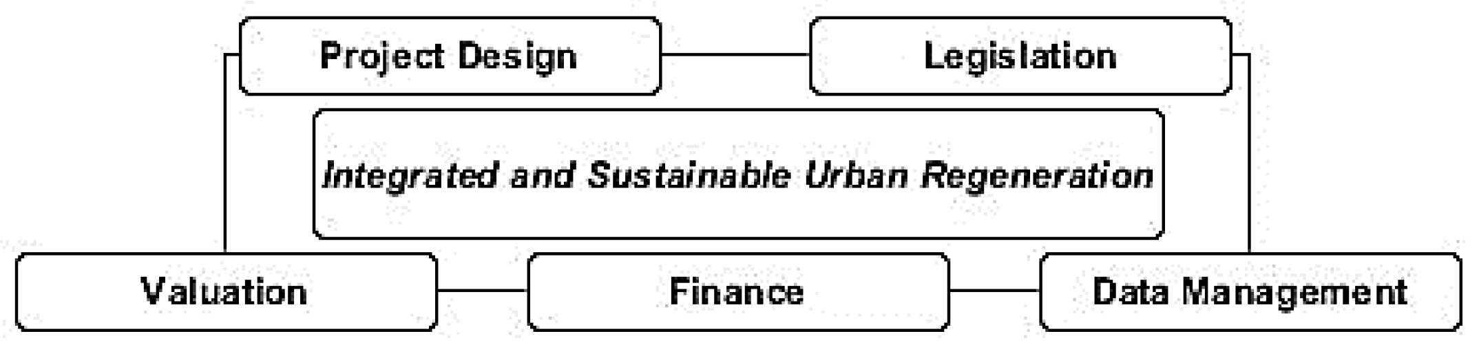
Law No. 6306 constitutes the legal basis for regeneration practices for the prevention of disaster risk in Turkey. The implementation of the areas and structures under disaster risk will be carried out in stages. First, determinations will be made to reveal the risk. Secondly it will be ensured that the area or building parcel is ready for conversion. In the third stage, it will be restructured or strengthened in accordance with current needs and techniques. However, Law No. 6306, which is described as a comprehensive and detailed urban regeneration practice, has several aspects that are legally and technically criticized. With this legislation, it is necessary to implement the projects to form the infrastructure of urban life in a sustainable manner and to support the legislation and practices for effective urban regeneration with the functional model. As in other planning processes, urban regeneration processes need to be formed according to a spatial base. Problems arising from a lack of institutional structure in urban regeneration applications, problems arising from local governments, lack of personnel with sufficient knowledge on the subject, problems due to lack of legislation, lack of selection of areas in a healthy way, problems encountered in informative studies of projects, differences in implementation approach of consultant firms and financing problems constitutes the main problem definitions for the holistic applications. This suggests that a healthy regeneration cannot be achieved unless the five main factors that presented in
Figure 2 are provided.
In this study, risky area determination processes within the scope of Law No. 6306 were examined and revealed, and disaster risk areas announced by the Ministry were mapped and evaluated. In order to determine the problem definitions that will emphasize the need for an urban regeneration model, which is aimed to be created with a holistic perspective different from the fragmented practices, the processes of urban regeneration within the scope of Law No. 6306 and the data produced/used in these processes were revealed. In the light of these data, the institution components, whose integration has gained importance according to the risky area criteria specified in the law, have been handled within the urban regeneration information system. The problem definitions for a geographic information system-based urban regeneration model that is aimed to be created are interpreted by mapping the criteria determined on the basis of the law numbered 6306. In line with the target, the criteria determined based on the law in the ‘Disaster Priority Regeneration Area (DPRA)’ in the Istanbul province have been made comprehensive by considering the district characteristics and pilot areas have been revealed by examining these criterias separately within the scope of the model. As a result of the study, it is aimed to create a holistic and sustainable model in determining the regeneration areas which will constitute the most important step of a geographic information system based urban regeneration model that will provide a basis for future applications. Thus, the importance of the model to be applied for the critical districts of Istanbul in the next phases of the study was emphasized with the data.
2. General Procedure and Key Concepts of the Study
Considering the planning dimension, the question of where to make urban regeneration is the first step of the regeneration. In Turkey, there is a significant number of risky regions in the earthquake zone which need to be regenerated. The current situation in the area to be determined is an issue that should be handled with precision in order to create the plan for the functional purpose. Considering the importance of this issue, first of all, it is necessary to decide on the function areas of the urban scale.
Areas that are at risk of loss of life and property, determined by the Ministry of Environment and Urbanization or Disaster Emergency Management Presidency and determined by the Council of Ministers upon the proposal of the Ministry, due to the ground structure or construction conditions, are defined as risky areas in the relevant law. In accordance with implementing Law No. 6306, the implementation of the Identification and Announcement of Regeneration Area step is set out in
Figure 3. In the figure, in addition to the risky area announcement stages in the law, the documents required to be included in the file to be submitted to the Ministry for the risky area proposal are shown. These documents constitute the beginning of the roadmap within the scope of the law for the criteria to be determined for the areas to be determined for disaster-oriented regeneration.
When the regeneration area is evaluated within the scope of ground structure; areas with earthquake risk, landslide areas, stream beds, flood areas, avalanches or areas where there is a possibility of falling rocks are identified as risky areas. In order for an area to be identified as risky area; the size of the area should be minimum 15.000 m2. However, if deemed necessary by the Ministry in terms of application integrity, the risky area can be determined regardless of the size of the parcels or parcels and without the requirement of 15.000 m2. In addition, in areas declared as risky areas; the whole authority passes to the Ministry and the administration to carry out the implementation after the announcement is obliged to request authorization from the Ministry. However, many urban regeneration projects are unfortunately cancelled by the judiciary. These problems, especially in the selection of risky areas, negatively affect the current implementation processes. Therefore, the risky area site selection is a major problem affecting the urban regeneration process currently in use. At this point, only the structures that are not risky in terms of the integrity of the application in Law No. 6306 brings into the scope of the regeneration discussions on the property right. In many cases against the risky area declaration process, the Council of State states that the necessary conditions for declaring a place as a risky area have not occurred and the execution and suspension decisions are made. According to the Council of State, in order to declare an area as a risky area, this area should have the risk of causing loss of life and property and it should be put forward in a manner that leaves no room for any doubt in accordance with the procedures and principles stated in the Regulation.
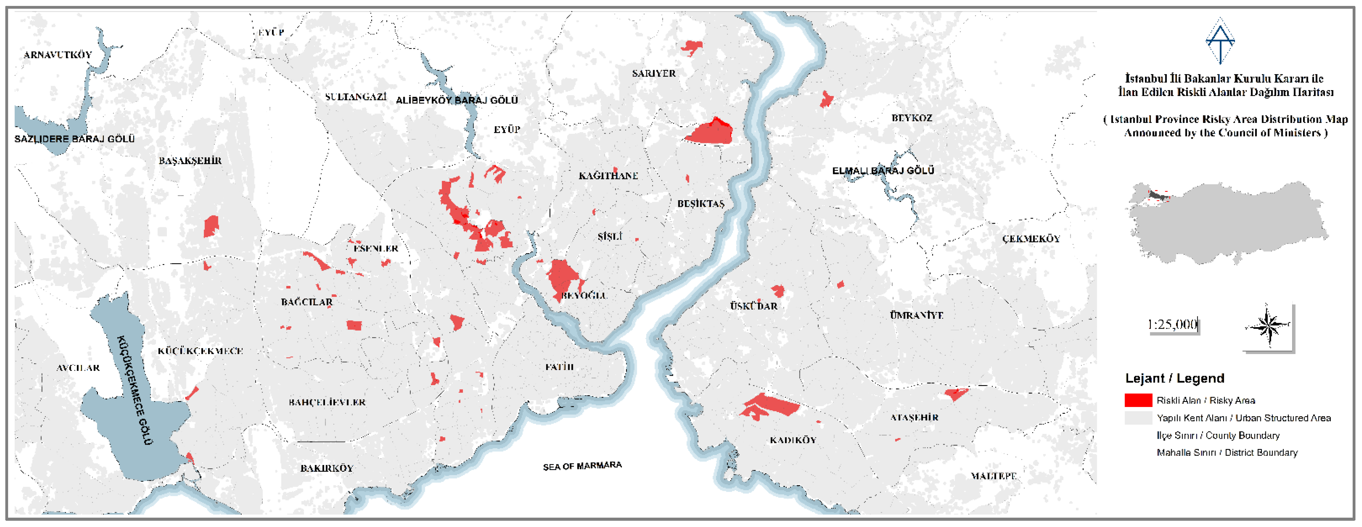
With Law No. 6306, 69 risky areas have been declared within the provincial borders of Istanbul shown in
Figure 4. It covers an area of 415.96 hectares in 17 risky areas in 8 districts on the Anatolian Side and 794.11 hectares in 55 risky areas in 15 districts on the European Side. A total area of 1210.07 hectares has been declared as a risky area. The population living in these areas is 29,964 in total, which corresponds to 2% of the population of Istanbul. The distribution of risky areas announced by the Council of Ministers and the balance in the distribution and the number of risky areas announced in districts with high fair value, reveal the necessity of creating a risk map for Istanbul. According to this risk map to be created, regeneration projects to be carried out according to certain criteria in places declared risky areas will lead to the implementation of disaster risk prevention.
The risk map created by considering the buildings for severe damage in the earthquake scenario in three different models revealed in the last report of the ‘Republic of Turkey Istanbul Disaster Prevention/Mitigation Basic Plan Study, Including Seismic Micro-zoning’ carried out by the Japanese International Cooperation Agency (JICA) in partnership with the Istanbul Metropolitan Municipality. As a result of Law No. 6306, the rate of compliance with the risk areas announced with the decision of the Council of Ministers was determined as 18.67% on the basis of neighborhoods and 9.06% on the basis of coordinated delimitation map data. This rate proves that in the regeneration process, which started with the aim of renovating more than 6.5 million houses in Turkey before a possible earthquake, the risky areas that have been projected since 2012 cannot be handled holistically without certain standards, and that it is far from realizing the target of preventing the disaster risk as intended in the law.
Within the scope of this study, a possible urban regeneration model with an automated site selection interface for ‘Disaster Priority Regeneration Area (DPRA)’ (risky areas) in Istanbul will provide a holistic and fast approach to the applications in the 1st degree earthquake zone. At this point, the right data and information is needed to make the right decision in the functional model intended for the study. In order to design the model, it is necessary to first determine the situation, design, develop and implement this plan, and the model should be sustainable. The most important component for functional model design is data management. The inputs and outputs that make up the model are clearly presented in
Figure 5 within the framework of the main process steps of urban regeneration. The data groups that should be included in the urban regeneration model to be created will be dealt with in this way, and an existing status database will be created. The data used and generated at every step of the implementation stages play a key role in the creation of data layers that should be included in an urban regeneration information system including which institutions should generate these data and which institutions should be integrated with each other. This institutional integration will ensure the continuity of the implementation of healthier practices by working with a forward-looking, sustainable and dynamic data set by preventing the duplication of data used. Data acquisitions should be carried out from these institutions, and data sharing from the relevant data directorates should be carried out quickly. According to the ‘Turkey National Geographic Information System (TUCBS) Project’ document, this structure, which should be created by taking into account the basic principles for the geographical data sets to be used in the establishment and operation of the TUCBS, can be expanded with this vision and can form the basis for the creation of dynamic databases for different sectors.
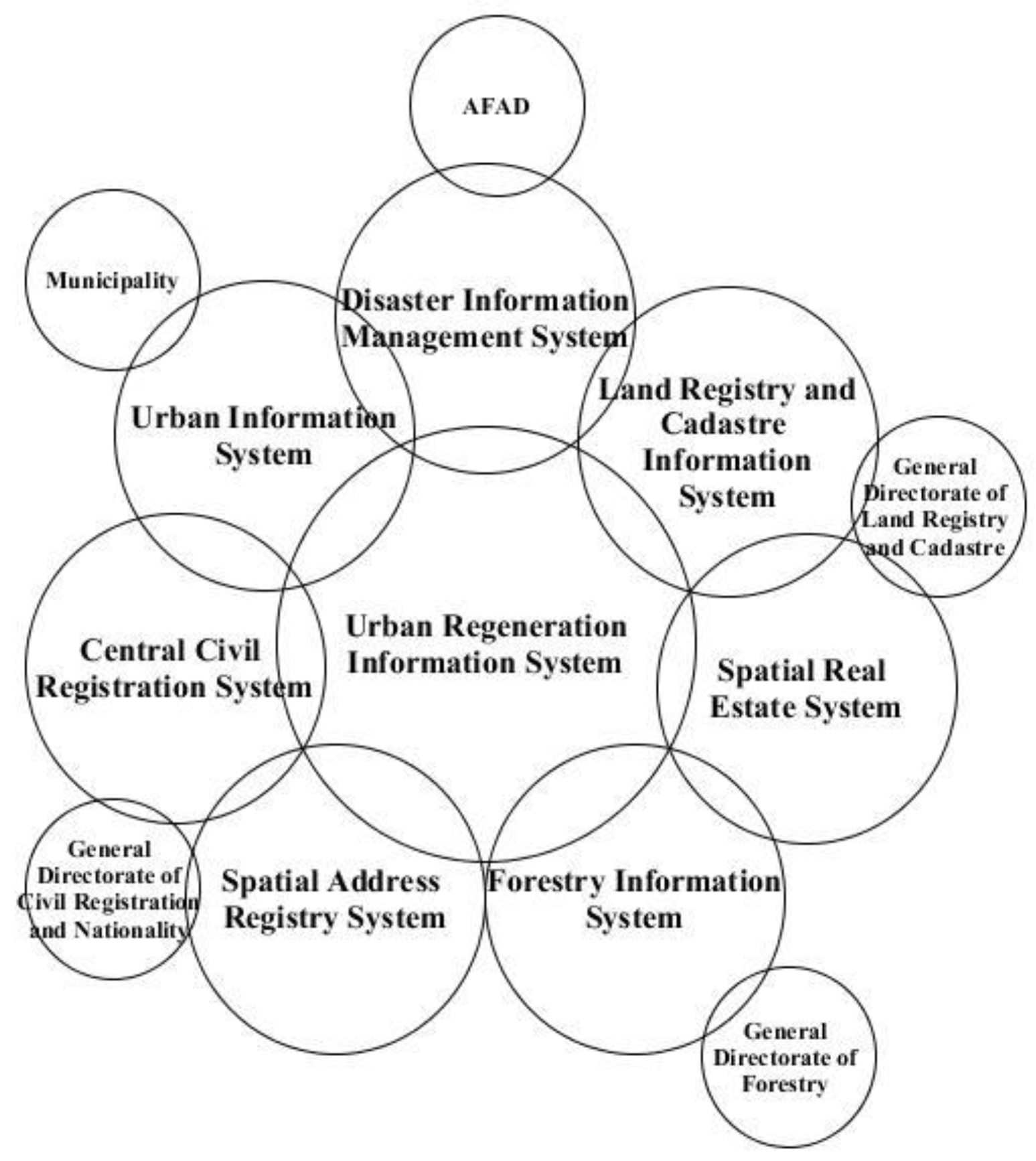
Even if the classification of the data module for the model to be designed is created by utilizing the urban regeneration spatial data infrastructure, it is clearly seen that different institutions and the data of these institutions should be integrated into the urban regeneration model being created. It is possible with GIS to ensure the data flow of national projects such as TAKBİS (Land Registry and Cadastre Information System), MERNİS (Central Population Administration System), MEGSİS (Spatial Real Estate System), and MAKS (Spatial Address Registration System) into the urban regeneration model (
Figure 6), but the emerging element to manage the structure in this dimension is the standard. General Directorate of Geographic Information Systems was established in Turkey to ensure the standard in data and information on the basis of TUCBS standards. Urban regeneration applications will be carried out in a faster, more efficient, sustainable and holistic way with a single database model that will be created as a result of data sharing and integration between institutions with the support of information systems.
In the light of all the information explained and before determining the criteria for the risky area declaration in relation to urban regeneration within the scope of Law no. 6306, the relevant legislation is examined and the existing criteria are revealed in the light of the documents revealed in this context. In the light of all the data disclosed, it can be said that in order to determine the regeneration areas, it is necessary to create the data model to be used before the legislation-based criteria, and to create the data to be used in the model with the help of the integration of the produced institutions. Within the scope of the study, “Analytical Data Preparation Work That Will Form a Basis for the Plans to Be Prepared with an Urban Regeneration Perspective” was carried out for all 39 districts within IMM in accordance with Law 6306 and other relevant legislation by the IMM Urban Regeneration Directorate. As a result of this process, the Istanbul Urban Regeneration Master Plan (IKDMP) [
13] was prepared. Most of the data sets used within the scope of this study were carried out with the data used in this project as of 2018.
4. Results
The concept of disaster-oriented urban regeneration, which is the basis of the law, greatly increases the importance of the ground structure and the building layer in the data set in this focus of the criteria in the law as seen in the
Figure 7. However, this key point raises doubts about the criteria by which the areas determined in the applications are determined. At this point, in order to understand whether the criteria obtained from the law are sufficient or to make the necessary additions to these criteria, it is necessary to reveal the problems experienced by evaluating the ongoing applications. In this part of the study, it is necessary to evaluate the criteria maps given in
Table 1 and to determine which districts should be prioritized in a comprehensive and integrated urban regeneration application within the scope of these maps.
Within the scope of the study, the use of PGA (maximum ground acceleration) at the point of seismicity was determined as the most appropriate evaluation criterion in this regard. PGA is an important parameter for earthquake hazard assessments. Information about the PGA characteristic caused by the earthquake can be obtained from the records of past earthquake events. Ground acceleration records allow extracting key features such as peak ground velocity from ground motion records, ground acceleration and earthquake acceleration at the ground surface can be calculated. PGA values can be calculated using the attenuation function. The attenuation function is a function that represents the difference between the intensity of local ground motion (a), the magnitude of the earthquake (M), and the distance (r) between points at the source of the earthquake [
14]. In the context of these parameters, AFAD Istanbul Disaster Hazard Maps, which were created on the basis of Boore and Atkinson’s work in 2006 [
15], were created using the maps created based on PGA in the 2002 Microzonation report of JICA in the context of geological parameters, and Istanbul Earthquake Hazard Map was created on
Figure 8. According to Building Earthquake Regulation, which came into force on 1 January 2019 determined by the decision of the Council of Ministers, unlike the previous map, PGA values were shown instead of the earthquake zones, and the concept of “earthquake zone” was removed. The fourth, third, and second zones on the old map were grouped under one zone, while the former zone one PGA value of 0.33 g is now divided into three separate zones. Considering this situation, only the coastal areas of Bakırköy and Beylikdüzü districts on the European Side of Istanbul, and the coastal region of Tuzla on the Anatolian Side, which have PGA above 0.33 g, enter this dangerous border. For this reason, within the scope of the study, first of all, earthquake risk zones were taken into consideration over the previously determined value classes for the province of Istanbul, and it was determined that the zoning of the classification values determined as 0.1 g–0.2 g–0.3 g–0.4 g. According to these earthquake zones was insufficient for the province of Istanbul within the scope of the study. For this reason, as seen in
Figure 6, PGA values of Istanbul province are divided into 8 classes. On the European Side; Büyükçekmece, Esenyurt, Beylikdüzü, Avcılar, Küçükçekmece, Bağcılar, Bahçelievler, Güngören, Bakırköy, Zeytinburnu and Fatih districts; on the Anatolian side, Tuzla, Sultanbeyli, Kartal, Maltepe and Ataşehir districts are located in high earthquake risk areas. Accordingly, considering the regions declared as risky areas by the decision of the Council of Ministers, the areas with PGA value between 0.2 g and 0.45 g are considered in areas with high earthquake risk such as Bağcılar, Küçükçekmece, Zeytinburnu, Kartal, Pendik, Esenler, Tuzla, and Güngören. But, rest of the risky areas such as Kağıthane, Beşiktaş, Üsküdar, Beyoğlu, Kadıköy, Sarıyer, Beykoz, Şişli with high land values causes the purpose of disaster-priority urban regeneration to be questioned. Considering the project situations, PGA value of the areas that are finished or ongoing from these areas is 0.2; 14 of these 27 areas have a PGA value of less than 0.2 g. The average PGA of the newly started projects is 0.19; 4 of these 6 areas have a PGA value of less than 0.2. Finally, the average PGA value of the projects that have not started yet was determined as 0.19; 20 of these 39 areas had a mean PGA of 0.2. However, before making this comment, other criteria should be evaluated, especially within the scope of ground structures.
Another criterion to be evaluated within the scope of ground structure is the landslide areas of Istanbul province. The risk categories used by the General Directorate of Mineral Research and Exploration (MTA) for Landslide Maps, the production of Urban Regeneration Landslide Exposure Map for the city of Istanbul and the landslide hazard level included in the Landslide Maps created by the IMM within the scope of the Microzonation study for the city of Istanbul. As seen in
Figure 9, when the risky areas announced by the Ministry within the scope of the map produced and the areas included in the active landslide risk category used by the MTA and the high-level risk areas from the landslide hazard areas classified by the IMM are intersected, all the announced risky areas are found in the medium danger areas in Bağcılar district. It has been determined that the intersections in Bayrampaşa, Esenler, Küçükçekmece, Zeytinburnu and Güngören districts are located in low-grade danger areas, apart from the risky areas in Güneşli and Evren neighborhoods located in these districts. It is obvious that the areas determined at this point were determined without considering the landslide danger.
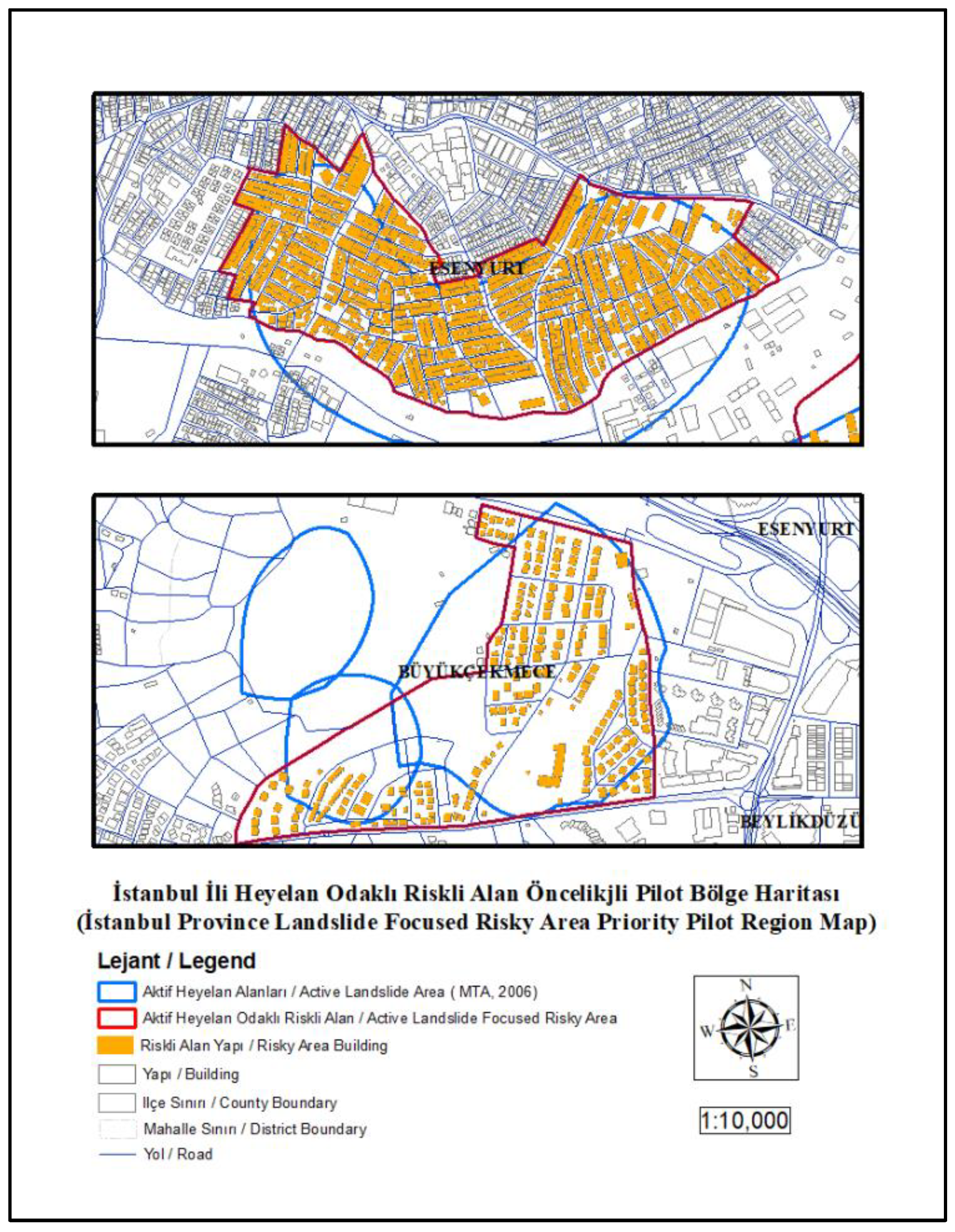
Considering that the active landslide zones describe the mass that is still in motion, as a result of analyzes carried out within the scope of the study, it has been determined that there are 6657 structures in the active landslide areas of the MTA and the high-risk landslide areas of the IMM. Especially in the districts of Büyükçekmece, Beylikdüzü, Esenyurt and Avcılar, in the regions where these areas are located, the announcements of the areas to be converted based on the landslide exposure of the danger areas, which are in the form of building clusters, should mostly be addressed. Within the scope of the study, two pilot areas were determined, as can be seen in
Figure 10, which can only be declared as landslide risk focused.
Since these pilot areas created for Büyükçekmece and Esenyurt districts are located in active landslide zones, there are 1850 buildings in these areas, which are recommended not to be subject to on-site regeneration. It is obvious that an urgent regeneration to be realized in these regions should be prioritized due to the number of buildings mentioned. Considering these assessments, these high-risk areas are classified as areas where construction is prohibited in high-scale plans. At this point, the landslide criterion should be considered not only for an urban regeneration model that will be handled with a disaster focus, but also for the province of Istanbul in order to evaluate whether the regeneration will be carried out on-site. The necessity of including the regeneration method in the model design to be created within the scope of the study is of great importance for a sustainable and future-oriented urban regeneration.
Another criterion in the law to be evaluated within the scope of ground structure is flood areas as seen in
Figure 11. Within the scope of the Flooding Exposure Map, which was produced by evaluating the flood risk areas and water basin protection area maps produced by the General Directorate of State Hydraulic Works (DSI) and the Istanbul Water and Sewerage Administration (ISKI), 18 areas from the risky areas announced by the Ministry intersect with these areas. There are a total of 1044 buildings in these areas. However, the number of buildings remaining in the primary protection zone of the watershed is 19,123. 8713 buildings in flood risky areas revealed by DSI, 40,370 buildings in flood risky areas classified according to 100 and 500-year flood flows revealed by ISKI, and 500 in 100-year flood flow rates. There are 16,308 buildings in the areas determined according to the annual flood flow. The fact that only 1044 buildings are located in the declared risky areas, out of 64,429 buildings (
Figure 11) in total, reveals that practices outside the purpose of disaster-oriented regeneration are carried out in areas to be realized in critical protection areas and where on-site regeneration should not be performed. At this point, within the scope of the study, considering the building blocks in the flood areas, 2 pilot regions within Bahçelievler and Güngören districts with priority to be announced were determined and the region boundaries are shown in
Figure 12 as an additional mapping. The presence of 1102 buildings only in these 2 regions shows that a healthier path can be followed for this criterion when compared with the areas announced so far. It is of great importance that the regions to be announced in these regions are also subject to the transformation as a priority, in order to prevent future consequences.
In the light of the data presented at this point, when the disaster-oriented criteria in the Law in terms of ground structure are evaluated, it is seen that the areas that are not suitable for on-site regeneration and that are under high disaster risk are not given priority in regeneration. Considering the building structure in these areas and the population living in these structures, it is suggested in the first stage of the targeted model that the regeneration should be carried out immediately in the proposed areas in the light of these data in a disaster-oriented urban regeneration model and that these areas should be handled as a priority.
The risk of soil liquefaction needs to be assessed before producing the final mapping of the ground condition. In general, soil liquefaction can be defined as the sudden decrease in the shear strength of the soil due to excessive pore water pressure generation in the soil during load application. As a result of the liquefaction of the ground, the structure may tend to sink into the ground or, in light structures, move upwards and float. In soils that lose their shear strength by liquefying, small shear stresses that change direction cause large deformations and soil collapse damages in structures. The liquefaction risk map (
Figure 13) created within the scope of the study has been revealed.
In the map created based on the classifications revealed by the IMM between 2007 and 2008, the current number of buildings in areas with liquefaction risk on the European Side is 27,051, while the number of buildings remaining in high-risk liquefaction areas is 1578. While the same rate is 27,661 on the Anatolian Side, the building rate is determined to be quite low. Among the risky areas declared by the Ministry so far, only the risky area located in Küçükçekmece Fatih neighborhood is among these risk areas. Considering the building blocks in high-risk liquefaction areas, recommendations for pilot disaster priority risky areas are presented in
Figure 13 as additional map.
At this point, the sub-classes belonging to the ‘areas with a construction ban’ created in the light of the data in the 1:5000 scale Master Development Plan are given in
Table 2. The ‘Istanbul Province Construction Prohibited Area Map’ created according to these sub-classes is presented in
Figure 14. These areas were created for each of the subclasses given in the table, were included in the study by foreseeing a more comprehensive study according to other criteria, and were revealed by highlighting the building stock within the areas requiring geological survey. In the light of these data, there are 95,590 buildings in all prohibited areas, and there are 12,347 buildings in 262 geologically undesirable areas in Istanbul.
In the light of the data revealed in the study, it can be said that the ground condition classification constitutes a data set group that should be used as a base before the mathematical model to be created and the characteristic data that are important for the creation of the model and the handling of a disaster-oriented urban regeneration.
It can be said that urban regeneration practices are based on two basic approaches. The first is “on-site conversion” and the second is “indirect conversion”. In the on-site regeneration method, the regenerated area is regenerated into a modern city by reviving or demolishing and reconstructing it, while in the indirect regeneration method, the people in the place to be regenerated are transferred to another place and that place is rebuilt. Although Law No. 6306 is open to discussion in many ways, it can be said that it adopts both approaches. At this point, these maps produced in the province of Istanbul with the focus of ‘Ground Structure’ are also of great importance in determining the areas where on-site regeneration is not suitable and interpreting that the regeneration should be done in these regions in an indirect way. Prior to the ‘Construction Status’ evaluations in the focus of the study, “Istanbul Province Ground Structure Suitability Map” was produced as seen in
Figure 15.
According to this map ground structure oriented indirect regeneration areas are determined using hazard rate reclassification maps. All ground structure-based analyzes were reclassified between 0 and 2 in the evaluation, and result map were produced with equal weights, and thus, it was determined that the zoning of class 2 in the result map was not suitable for on-site regeneration. The map, within the scope of the analysis, the PGA values were handled separately and it was ensured that the earthquake hazard zonings were also seen on the map. When the DPRA to be revealed at the end of the study are located in these areas, the appropriate regeneration method will be revealed in accordance with the model.
When the building data purchased within the scope of the study is examined, before the evaluations are made according to the construction status within the scope of the study; in order to reveal how this evaluation scope expected in Law no. 6306 will be revealed according to the existing data, the building data layer attribute information has been examined. As a result, it has been understood that taking into account the slum areas, the occupancy status of the buildings, the number of building height, the age of the building and the building damage score analyzes produced in previous studies in the province of Istanbul is of critical importance for the determination of disaster-oriented regeneration areas. For the building data, the ‘Istanbul Province Building Vulnerability Map’ (
Figure 16) was produced at the first stage. The percentage damage data used in the production of this map is taken from the IKDMP study. In the attribute information of the data, there are many parameters that represent the building damage risk. In the earthquake scenarios created in line with the information received, the percentage of completely destroyed or largely damaged buildings in the district and the values in the field named “Proportion_Damaged_Buildings” in the attribute table of the data were used. Values between 0.25 and 8.2 are included in this field. The total number of district residences in the attribute table of the same layer are also shown as legends on the map. As seen on the map, the districts with the highest building damage percentage are Bakırköy, Beylikdüzü and Fatih. Among these districts, Bakırköy 7.7, Beylikdüzü 6.0 and Fatih 5.5 are the districts with a building damage percentage. When these areas are compared with the areas announced by the Ministry, the fact that none of the 72 risky areas are located in these districts shows that the building damage percentages for these identified areas are not taken into account in the determination of risky areas. While the percentage of building damage in Bağcılar district, which constitutes the majority of the declared risky areas, is 2.8, it is limited to 1.4 in Gaziosmanpaşa district and 2.1 in Esenler district. In order to meet the criteria of illegal buildings set forth in
Table 1 in Law 6306 on the map, the classification of slums, empty buildings and non-accessible buildings is also included in the legend.
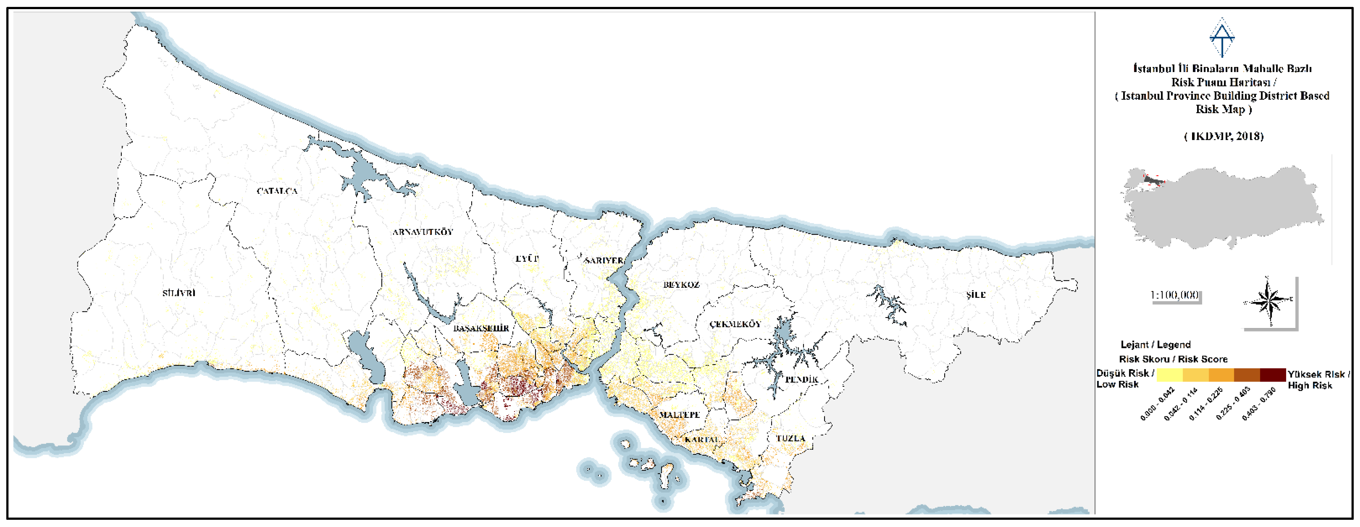
Another of the criteria maps focused on construction status is the ‘Istanbul Province District-Based Building Risk Score Map’ (
Figure 17). In this case, the building neighborhood risk scores vary between 0 and 0.79. This risk scoring was created according to the earthquake risk scenarios discussed in the IKDMP project carried out by IMM. Districts with the highest risk score in scoring; it is determined as Bahçelievler, Avcılar and Bakırköy. While the risk scores of Bahçelievler, Şirinevler, Zafer, Kocasinan and Siyavuşpaşa districts in Bahçelievler district vary between 0.79 and 0.537, the risk scores of Denizköşkler, Cihangir, Ambarlı, Merkez and Gümüşpala districts in Avcılar district vary between 0.446 and 0.709. At this point, when the overlaps between the risky areas announced by the Ministry and the districts with the highest risk scores are evaluated, the risky areas announced by the Ministry vary between 0.001 and 0.437 risk points. The mean risk score of these risky areas is seen as 0.096. These overlapping areas with a risk score above 0.2 are Küçükçekmece Kanarya district, Zeytinburnu Telsiz, Sümer, Beştelsiz, Seyitnizam districts and Bağcılar Evren district. At this point, while the average risk score of the areas produced by the Ministry is 0.096, if the risk score diversity of the province of Istanbul can score between 0 and 0.79, this shows that the Ministry does not take into account the studies carried out in the focus of previous studies within the framework of Istanbul. In a disaster-focused urban regeneration target, the fact that these studies, which are created by considering a parameter that can save many lives in a possible disaster such as a construction situation, are not taken into account.
Building age data are available in most of the studies around the world regeneration examples where the vulnerability of the building was measured. The construction type of the overall building stock in Istanbul is mostly reinforced concrete. It is known that concrete wears out over time and loses its function. Although there are many studies on the life of concrete, detailed studies such as the production stage and raw material of the concrete in question are in question in the studies carried out in this detail. For this reason, the announcement date of the earthquake regulations was taken as a reference, without making a classification based on the life of the concrete. At the same time, an alternative construction year data has been used as an alternative to this data, assuming that the contract dates are the construction year. In the study, the construction year data were evaluated in 3 main classes as structures before 1980, structures between 1980 and 2000, structures after 2000 (
Figure 18). However, even though there are building license dates used within the scope of IKDMP study between 2002 and 2008 in the building data attribute data produced and used in the studies, there is no construction year data belonging to the general building inventory data. At this point, it is not possible to determine a healthy risky area within the scope of this deficiency. It is seen that the building data needs to be qualified by updating it in TUCBS standards. At the same time, although these two studies conducted on the building inventory within the scope of IKDMP studies predict that 48 thousand buildings will be demolished throughout Istanbul, apart from this study, building column statics and building skeleton structure were examined in detail within a study, which was carried out in two districts, predicts that 109 thousand buildings will be demolished. However, at this point, the fact that the study sample was made only in two districts causes question marks in the minds. However, considering both figures and the population living in these buildings, it is obvious that they reveal the worst scenario that may occur in case of a delay in disaster-oriented regeneration. As a result of these works the areas that are determined correctly should be regenerate rapidly. It is of great importance at this point that it is necessary to understand that the increase in density is far from a solution and that the plan changes should be handled depending on the upper scale plans. In order to solve the financial pillar of urban regeneration on this basis, a new finance model should be developed under the direction of public-private partnerships.
The data on the building heights are handled in two different subjects in these earthquake risk studies. The building height can affect the extent of damage with its response to the ground during an earthquake. When considered within this framework, the type of ground structure is evaluated together with parameters such as the earthquake history of the relevant area. However, in addition to the reaction of the building height to the ground within the scope of the study, the fact that building height is frequently seen in applications other than plan rights in Istanbul makes it difficult to handle this criterion in a healthy way. In addition, the building height should not be considered alone. Buildings that are built according to the new earthquake regulation and the construction year of the building is new, regardless of the building heights, should be included in the study as durable structures. At this point, it has been ensured that buildings after 2008 should not be included in this criterion in the building inventory. However, considering that the construction year data is not healthy, the contribution of this criterion to the result will not give a qualified result. But according to the law, building height map is produced within the scope of the study (
Figure 19).
In the light of these data, another parameter to be considered for the ‘Determination of Disaster-Oriented Regeneration Area’ model to be implemented throughout the province of Istanbul stands out. Making these areas to be determined throughout the province for districts depending on different ground structure and construction may result in insufficient results in some districts. At this point, in addition to the application of the model throughout the province of Istanbul, revealing the priority areas on the basis of districts will provide healthier results and more accurate interpretations at the district scale. In the later stages of the study, the areas to be revealed by using the appropriate mathematical model throughout Istanbul will be compared with the district-based results and the differences will be evaluated.
In the light of the information revealed so far within the scope of this study, Beylikdüzü district has 10,867 buildings. The district is located in the high-risk earthquake zone with a PGA (g) value between 0.26 and 0.38. Additionally Beylikdüzü district is not among the areas announced by the decision of the Council of Ministers. Beylikdüzü district, which is a district with a stockpile, has been determined as a pilot district. As can be seen in
Figure 20, areas with active landslides, floods, protection areas, and construction bans in the district ground structure are considered as areas that are not suitable for on-site regeneration. When these regions are examined, it has been determined that 8708 buildings are located in these areas in the district. In order to determine the areas that can be recommended for on-site regeneration, the building conditions in Barış (0.363) and Yakuplu (0.342) neighborhoods, which are the two neighborhoods with the highest neighborhood risk score, were examined. Considering the regulations that came into force after the 1999 Marmara Earthquake, when the pre-2000 construction and the structures above 10 floors are evaluated, many building blocks emerge within the scope of the district.
According to the report prepared as a result of earthquake scenarios made by JICA, the building damage rate in Beylikdüzü is 0.6. This ratio shows that Fatih, Avcılar, Bahçelievler and Bakırköy are among the districts with the highest building damage score. Additionally, heavy damage is expected in a possible earthquake in 30 natural gas, 84 waste water, and 49 drinking water lines in the district. At this point, the fact that the regeneration has not yet started in this district shows that the disaster-oriented regeneration has not been implemented in accordance with its purpose. When construction status is evaluated, 6262 of the total building stock in Beylikdüzü district was built before 2000; 301 of these buildings are located in Barış and 1693 in Yakuplu Neighborhood. 246 of these buildings in Barış Neighborhood are structures with 10 floors and above. In Barış and Yakuplu, the minimum area size was determined as 30,000 m
2 and the public land ratio were taken into account in order to prioritize these areas to the determined building blocks by examining the ‘suitability for settlement’ and the construction status. As a result of analyzes made, the ‘Disaster Oriented Regeneration Area’ determined for two on-site regeneration is presented in
Figure 21.
5. Discussion
A disaster-oriented urban regeneration, which will be handled in the focus of Law No. 6306 and the regulations of the relevant law, is of vital importance considering the expected Istanbul earthquake on the North Anatolian Fault Line—East Ridge North Fault. When the studies carried out for the province of Istanbul are examined, these studies focused on scenarios that prove the need for this regeneration and revealed the damage rates expected to occur as a result of these earthquake scenarios. At this point, within the scope of the study for a disaster-oriented regeneration with an emphasis on earthquake focus, the determination of risky area among the regeneration methods determined as risky structure and risky area in Law No. 6306 was considered as the fastest and most effective method for solution. At this point, first of all, these areas should be determined in a healthy way with an integrated, sustainable and automated urban regeneration model, and then the regeneration methods to be applied in these areas and the financial models to be used should be determined and the regeneration of these areas should be started quickly. The law numbered 6306, which was put into practice in 2012, was examined within the scope of the study, and how this mechanism could be operated with the data inventory in practice was examined. However, at this point, it is of great importance to evaluate the contribution of the risky areas announced by the Ministry since 2012 to the regeneration of Istanbul and whether there is a standard applied in the determination of these areas, in order to observe the difference between the application and the model to be created within the scope of the law-oriented study. In this context, the necessary criteria for the model were handled together with the existing data inventory in practice, and it was revealed in which areas these maps require regeneration and what problems can be experienced in these areas. The maps created as a result of these evaluations were compared with the risky areas announced by the decision of the Council of Ministers, and it was seen that the necessary evaluations and a standard were not applied for these areas determined in practice. At this point, it can easily be seen that this model to be created will not give sufficient results for the regeneration studies in order for the works carried out to be qualified.
For the province of Istanbul, it can be easily seen that many districts have different ground structure, building inventory and demographic structure. Due to the ground structure, it can be determined that high-risk areas should not be regenerated on-site, and as a result of these analyzes, which districts should be regenerated first. At this point, it is necessary to prioritize the districts such as Bahçelievler, Bakırköy, Avcılar, Beylikdüzü, and Zeytinburnu in the regeneration and the criterion weightings in the regeneration models should be handled separately for each district. In the later stages of the study, this finalization will be handled in a pilot district with weak ground structure, and at the same time, it will be implemented in a district with high land value and within the risky area announced by the Ministry, to ensure the control of the proposals within the scope of the study. It should not be forgotten that determining DPRA within the scope of the law for an expected earthquake and bringing the regeneration to a conclusion will save lives and form the basis for future targets in a possible scenario.
When we look at the other studies, it is easily seen that no study has been carried out to create a comprehensive urban regeneration model for the province of Istanbul. All the partial studies carried out were used as data source and reference within the scope of the study. At this point, in the next stages of the study, the data set theme will be to obtain the ‘Building Damage Analysis’ results, which will be obtained as a result of an up-to-date earthquake scenario, which will be carried out primarily by determining the Hazard, Sensitivity, Risk and Exposure distinctions of the data with clear lines. Then, the total risks and exposures will be revealed with the criterion weights obtained from the AHP survey as a result of the roadmap drawn by using this study, and the raster-based final product evaluation to be obtained will be revealed. This study will ensure that the necessity of these analyzes, which are currently being developed, the deficiency in the practices even when the studies are carried out in a basic way, the importance of disaster risk and the DPRA will be revealed and the areas in which the regeneration should be initiated will be determined clearly throughout the province. Another study is carried out to determine the properties in the hands of local governments for housing production in the whole province and the areas where housing can be produced in areas with housing problems. An integrated urban regeneration should not be limited to the identification of regeneration areas; in order to develop district strategies and to put forward sustainable solution proposals, regeneration can be realized by considering the housing problem and housing production together. This study was carried out in terms of being a base and a reason for this result.


