
Modeling of Daytime and Nighttime Surface Urban Heat Island Distribution Combined with LCZ in Beijing, China


Abstract
:1. Introduction
2. Materials and Methods
2.1. Study Area
2.2. Research Data
2.3. Research Methods
2.3.1. Local Climate Zones (LCZs)
2.3.2. Land Surface Temperature Retrieval
2.3.3. Definition and Classification of SUHI Intensity
2.3.4. Parameter Value Extraction and Statistical Analysis
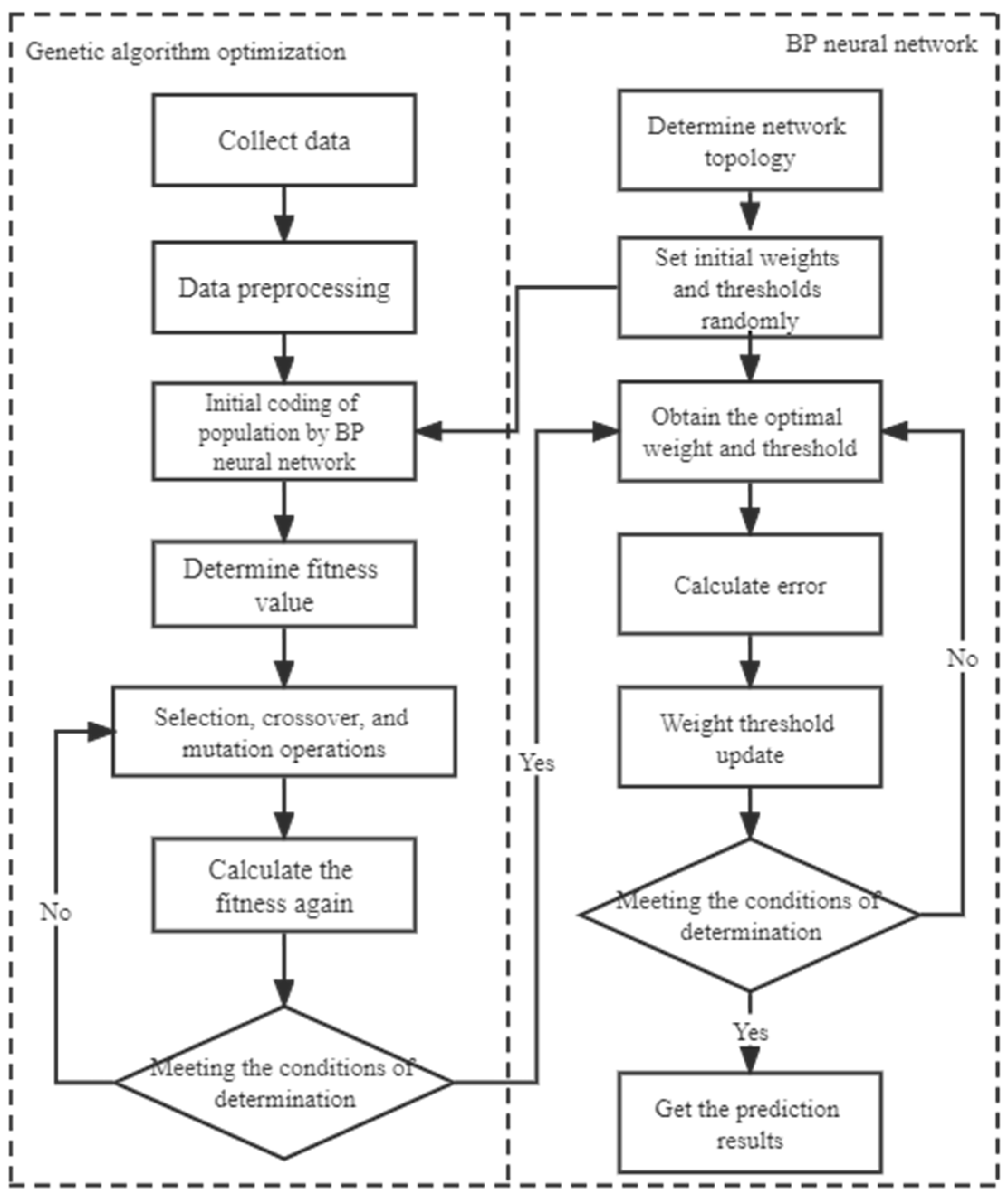
2.3.5. Artificial Neural Network Model
2.3.6. Evaluation Metrics
3. Results and Discussion
3.1. LCZ Mapping Results
3.2. Distribution of SUHI
3.3. Analysis of the Correlation between Each Index and SUHI
3.4. Performance Evaluation of the Development Model
3.5. Model Validation
4. Conclusions
Author Contributions
Funding
Conflicts of Interest
References
- Howard, L. The Climate of London, Deduced from Meteorological Observations; Cambridge University Press: Cambridge, UK, 2012. [Google Scholar]
- Georgescu, M.; Moustaoui, M.; Mahalov, A.; Dudhia, J. Summer-time climate impacts of projected megapolitan expansion in Arizona. Nat. Clim. Chang. 2013, 3, 37–41. [Google Scholar] [CrossRef]
- Zheng, H.; Chen, Y.; Ding, W.; Pan, W.; Cai, Y. Characteristics of Land Surface Temperature Disturbance and Its Relationship to Built-up Land Expansion. J. Geo-Inf. Sci. 2018, 20, 1529–1540. [Google Scholar]
- McCarthy, M.P.; Best, M.J.; Betts, R.A. Climate change in cities due to global warming and urban effects. Geophys. Res. Lett. 2010, 37, L09705. [Google Scholar] [CrossRef] [Green Version]
- Arshad, S.; Ahmad, S.R.; Abbas, S.; Asharf, A.; Siddiqui, N.A.; Islam, Z.U. Quantifying the contribution of diminishing green spaces and urban sprawl to urban heat island effect in a rapidly urbanizing metropolitan city of Pakistan. Land Use Policy 2021, 113, 105874. [Google Scholar] [CrossRef]
- Radfar, M. Urban Microclimate, Designing the Spaces Between Buildings. Hous. Stud. 2012, 27, 293–294. [Google Scholar] [CrossRef]
- Zhang, J.; Li, Z.; Hu, D. Effects of urban morphology on thermal comfort at the micro-scale. Sustain. Cities Soc. 2022, 86, 104150. [Google Scholar] [CrossRef]
- Guo, G.; Zhou, X.; Wu, Z.; Xiao, R.; Chen, Y. Characterizing the impact of urban morphology heterogeneity on land surface temperature in Guangzhou, China. Environ. Model. Softw. 2016, 84, 427–439. [Google Scholar] [CrossRef]
- Wang, Y.; Zhan, Q.; Ouyang, W. How to quantify the relationship between spatial distribution of urban waterbodies and land surface temperature? Sci. Total. Environ. 2019, 671, 1–9. [Google Scholar] [CrossRef]
- Yin, C.; Yuan, M.; Lu, Y.; Huang, Y.; Liu, Y. Effects of urban form on the urban heat island effect based on spatial regression model. Sci. Total Environ. 2018, 634, 696–704. [Google Scholar] [CrossRef]
- Feng, Y.; Du, S.; Myint, S.W.; Shu, M. Do Urban Functional Zones Affect Land Surface Temperature Differently? A Case Study of Beijing, China. Remote Sens. 2019, 11, 1802. [Google Scholar]
- Zhang, H.; Qi, Z.-F.; Ye, X.-Y.; Cai, Y.-B.; Ma, W.-C.; Chen, M.-N. Analysis of land use/land cover change, population shift, and their effects on spatiotemporal patterns of urban heat islands in metropolitan Shanghai, China. Appl. Geogr. 2013, 44, 121–133. [Google Scholar] [CrossRef]
- Stewart, D.; Orke, T.R. Local climate zones for urban temperature studies. Bull. Am. Meteorol. Soc. 2012, 93, 1879–1900. [Google Scholar] [CrossRef]
- Bechtel, B.; Alexander, P.J.; Böhner, J.; Ching, J.; Conrad, O.; Feddema, J.; Mills, G.; See, L.; Stewart, I. Mapping Local Climate Zones for a Worldwide Database of the Form and Function of Cities. ISPRS Int. J. Geo-Inf. 2015, 4, 199–219. [Google Scholar] [CrossRef] [Green Version]
- Ching, J.; Mills, G.; Bechtel, B.; See, L.; Feddema, J.; Wang, X.; Ren, C.; Brousse, O.; Martilli, A.; Neophytou, M.; et al. WUDAPT: An Urban Weather, Climate, and Environmental Modeling Infrastructure for the Anthropocene. Bull. Am. Meteorol. Soc. 2018, 99, 1907–1924. [Google Scholar] [CrossRef] [Green Version]
- Badaro-Saliba, N.; Adjizian-Gerard, J.; Zaarour, R.; Najjar, G. LCZ scheme for assessing Urban Heat Island intensity in a complex urban area (Beirut, Lebanon). Urban Clim. 2021, 37, 100846. [Google Scholar] [CrossRef]
- O’Malley, C.; Kikumoto, H. An investigation into heat storage by adopting Local Climate Zones and nocturnal-diurnal urban heat island differences in the Tokyo Prefecture. Sustain. Cities Soc. 2022, 83, 103959. [Google Scholar] [CrossRef]
- Yang, J.; Ren, J.; Sun, D.; Xiao, X.; Xia, J.C.; Jin, C.; Li, X. Understanding land surface temperature impact factors based on local climate zones. Sustain. Cities Soc. 2021, 69, 102818. [Google Scholar] [CrossRef]
- Hu, J.; Yang, Y.; Pan, X.; Zhu, Q.; Zhan, W.; Wang, Y.; Ma, W.; Su, W. Analysis of the Spatial and Temporal Variations of Land Surface Temperature Based on Local Climate Zones: A Case Study in Nanjing, China. IEEE J. Sel. Top. Appl. Earth Obs. Remote Sens. 2019, 12, 1–11. [Google Scholar] [CrossRef]
- Cai, M.; Ren, C.; Xu, Y. Investigating the relationship between local climate zone and land surface temperature. In Proceedings of the 2017 Joint Urban Remote Sensing Event (JURSE), Dubai, United Arab Emirates, 6–8 March 2017. [Google Scholar]
- Simanjuntak, R.M.; Kuffer, M.; Reckien, D. Object-based image analysis to map local climate zones: The case of Bandung, Indonesia. Appl. Geogr. 2019, 106, 108–121. [Google Scholar] [CrossRef]
- Peng, S.; Piao, S.; Ciais, P.; Friedlingstein, P.; Ottle, C.; Bréon, F.-M.; Nan, H.; Zhou, L.; Myneni, R.B. Response to Comment on “Surface Urban Heat Island Across 419 Global Big Cities”. Environ. Sci. Technol. 2012, 46, 6889–6890. [Google Scholar] [CrossRef]
- Zhang, H.; Hanqiu, X.U.; Le, L.I.; Fan, Y.P. Analysis of the relationship between urban heat island effect and urban expansion in Chengdu, China. J. Geo-Inf. Sci. 2014, 16, 70–78. [Google Scholar]
- Chen, Y.; Peng, R.C.; Zhang, L.H.; Dong, J.; Ning, L.I. Application of semi-variogram in analyzing spatial construction of sounding field. Hydrogr. Surv. Charting 2011, 06, 63–65. [Google Scholar]
- Lau, K.; Chao, R.; Yuan, S.; Zheng, V.; Lai, D. Determining the optimal size of local climate zones for spatial mapping in high-density cities. In Proceedings of the 9th International Conference on Urban Climate (ICUC9), Toulouse, France, 20–24 July 2015. [Google Scholar]
- Zheng, Y.; Ren, C.; Xu, Y.; Wang, R.; Ho, J.; Lau, K.; Ng, E. GIS-based mapping of Local Climate Zone in the high-density city of Hong Kong. Urban Clim. 2017, 24, 419–448. [Google Scholar] [CrossRef]
- Conrad, O.; Bechtel, B.; Bock, M.; Dietrich, H.; Fischer, E.; Gerlitz, L.; Wehberg, J.; Wichmann, V.; Böhner, J. System for Automated Geoscientific Analyses (SAGA) v. 2.1.4. Geosci. Model Dev. 2015, 8, 2271–2312. [Google Scholar] [CrossRef]
- Han-Qiu, X.U. A study on information extraction of water body with the modified normalized difference water index (MNDWI). J. Remote Sens. 2005, 9, 595. [Google Scholar]
- Gillespie, A.; Rokugawa, S.; Matsunaga, T.; Cothern, J.S.; Hook, S.J.; Kahle, A.B. A temperature and emissivity separation algorithm for Advanced Spaceborne Thermal Emission and Reflection Radiometer (ASTER) images. IEEE Trans. Geosci. Remote Sens. 1998, 36, 1113–1126. [Google Scholar] [CrossRef]
- Qin, Z.; Li, W.; Gao, M.; Zhang, H. Estimation of land surface emissivity for Landsat TM6 and its application to Lingxian region in North China. In Proceedings of the Remote Sensing for Environmental Monitoring, GIS Applications, and Geology VI, Stockholm, Sweden, 3 October 2006; p. 6366. [Google Scholar]
- Song, J.; Wang, Z.-H.; Myint, S.W.; Wang, C. The hysteresis effect on surface-air temperature relationship and its implications to urban planning: An examination in Phoenix, Arizona, USA. Landsc. Urban Plan. 2017, 167, 198–211. [Google Scholar] [CrossRef]
- García, D.H.; Díaz, J.A. Modeling of the Urban Heat Island on local climatic zones of a city using Sentinel 3 images: Urban determining factors. Urban Clim. 2021, 37, 100840. [Google Scholar] [CrossRef]
- Li, B.; Wang, N.; Chen, J. GIS-Based Landslide Susceptibility Mapping Using Information, Frequency Ratio, and Artificial Neural Network Methods in Qinghai Province, Northwestern China. Adv. Civ. Eng. 2021, 2021, 1–14. [Google Scholar] [CrossRef]
- Equere, V.; Mirzaei, P.A.; Riffat, S.; Wang, Y. Integration of topological aspect of city terrains to predict the spatial distribution of urban heat island using GIS and ANN. Sustain. Cities Soc. 2021, 69, 102825. [Google Scholar] [CrossRef]
- Liu, S.Q. Research and application on matlab BP neural network. Comput. Eng. Des. 2003, 11, 81–83. [Google Scholar]
- Sun, Y.; Xue, B.; Zhang, M.; Yen, G.G.; Lv, J. Automatically Designing CNN Architectures Using the Genetic Algorithm for Image Classification. IEEE Trans. Cybern. 2020, 50, 1–15. [Google Scholar] [CrossRef] [PubMed] [Green Version]
- Aras, S.; Kocakoç, I.D.; Polat, C. Comparative study on retail sales forecasting between single and combination methods. J. Bus. Econ. Manag. 2017, 18, 803–832. [Google Scholar] [CrossRef] [Green Version]
- Davydenko, A.; Fildes, R. Measuring forecasting accuracy: The case of judgmental adjustments to SKU-level demand forecasts. Int. J. Forecast. 2013, 29, 510–522. [Google Scholar] [CrossRef]
- Estoque, R.C.; Murayama, Y. Classification and change detection of built-up lands from Landsat-7 ETM+ and Landsat-8 OLI/TIRS imageries: A comparative assessment of various spectral indices. Ecol. Indic. 2015, 56, 205–217. [Google Scholar] [CrossRef]
- Zhang, X.; Zhong, T.; Feng, X.; Wang, K. Estimation of the relationship between vegetation patches and urban land surface temperature with remote sensing. Int. J. Remote Sens. 2009, 30, 2105–2118. [Google Scholar] [CrossRef]
- Xi, C.; Ren, C.; Wang, J.; Feng, Z.; Cao, S.-J. Impacts of urban-scale building height diversity on urban climates: A case study of Nanjing, China. Energy Build. 2021, 251, 111350. [Google Scholar] [CrossRef]
- Ramaiah, M.; Avtar, R.; Rahman, M. Land Cover Influences on LST in Two Proposed Smart Cities of India: Comparative Analysis Using Spectral Indices. Land 2020, 9, 292. [Google Scholar] [CrossRef]
- Liang, S.L.; Shuey, C.J.; Russ, A.L.; Fang, H.L.; Chen, M.Z.; Walthall, C.L.; Daughtry, C.S.T.; Hunt, R. Narrowband to broadband conversions of land surface albedo: II. Validation. Remote Sens. Environ. 2003, 84, 25–41. [Google Scholar] [CrossRef]


| Types | Resolution | Purpose | Data Source |
|---|---|---|---|
| Landsat 8 image | 30 m | Calculate NDVI, daytime surface temperature, and other indices | earth.explorer.usgs.gov |
| Building data | vector data | Calculate building height and building density | Baidumap |
| Impervious surface data | 30 m | Calculate impervious rate | data.ess.tsinghua.edu.cn |
| Google Earth image | 0.92 m | Select training samples | Google Earth Pro |
| AST_08 surface temperature products | 90 m | Calculate night surface temperature | search.earthdata.nasa.gov |
| Heat Island Strength Grade | Partition Interval |
|---|---|
| Cold island region | |
| Weak heat island region | |
| Medium heat island region | |
| Strong heat island region | |
| Super heat island region |
| Parameters | Basic Data | Definition | Meaning of Thermal Environment |
|---|---|---|---|
| H | Building data | Average value of building height per unit surface | Reflect local airflow and heat dissipation |
| BD | Building data | Ratio of building base area per unit surface to unit surface area | Reflect surface radiation heat gain, local air flow, and heat dissipation |
| ISF | Remote sensing data | Proportion of impervious surface coverage in unit surface | Reflect surface radiant heat gain and surface runoff |
| Albedo | Remote sensing data | Ratio of the emitted energy to the incident energy of the target | Reflectivity of the earth’ s surface to solar radiation |
| NDVI | Remote sensing data | Proportion of vegetation coverage per unit surface | Reflect heat from surface radiation and conversion of material and energy |
| MNDWI | Remote sensing data | Proportion of water body coverage per unit surface | Reflect surface water and evaporation cooling |
| LCZ | 1 | 2 | 3 | 4 | 5 | 6 | 8 | 9 | 10 | T | G | Total | UA (%) |
|---|---|---|---|---|---|---|---|---|---|---|---|---|---|
| 1 | 199 | 2 | 1 | 2 | 1 | 0 | 3 | 0 | 0 | 1 | 1 | 210 | 94. 8 |
| 2 | 0 | 20 | 0 | 0 | 0 | 0 | 0 | 0 | 0 | 0 | 0 | 20 | 100.0 |
| 3 | 0 | 0 | 38 | 0 | 0 | 0 | 2 | 0 | 0 | 0 | 0 | 40 | 95.0 |
| 4 | 0 | 0 | 0 | 37 | 1 | 0 | 3 | 0 | 1 | 0 | 1 | 43 | 86.1 |
| 5 | 0 | 0 | 0 | 0 | 20 | 0 | 0 | 0 | 0 | 0 | 0 | 20 | 100.0 |
| 6 | 0 | 0 | 1 | 0 | 1 | 18 | 0 | 0 | 0 | 0 | 0 | 20 | 90.0 |
| 8 | 0 | 0 | 2 | 1 | 0 | 1 | 60 | 0 | 0 | 0 | 0 | 64 | 93.8 |
| 9 | 0 | 0 | 0 | 0 | 0 | 0 | 0 | 10 | 0 | 0 | 0 | 10 | 100.0 |
| 10 | 0 | 0 | 0 | 0 | 0 | 0 | 0 | 0 | 9 | 0 | 0 | 9 | 100.0 |
| T | 0 | 0 | 0 | 0 | 0 | 2 | 0 | 0 | 0 | 40 | 1 | 43 | 93.0 |
| G | 0 | 0 | 0 | 0 | 0 | 0 | 0 | 0 | 0 | 0 | 29 | 29 | 100.0 |
| Total | 199 | 22 | 42 | 40 | 23 | 21 | 68 | 10 | 10 | 41 | 32 | 508 | |
| PA (%) | 100.0 | 91.0 | 90.5 | 92.5 | 87.0 | 85.7 | 88.2 | 100.0 | 90.0 | 97.6 | 90.6 | ||
| Total accuracy = 94.49%, kappa coefficient = 0.93 | |||||||||||||
| R2 | RMSE | MAE | MAPE | |
|---|---|---|---|---|
| WO-LCZ | 0.745 | 1.318 | 1.003 | 2.61% |
| W-LCZ | 0.817 | 1.076 | 0.821 | 2.15% |
| R2 | RMSE | MAE | MAPE | |
|---|---|---|---|---|
| WO-LCZ | 0.563 | 2.149 | 1.608 | 3.75% |
| W = LCZ | 0.595 | 2.062 | 1.525 | 3.58% |
Publisher’s Note: MDPI stays neutral with regard to jurisdictional claims in published maps and institutional affiliations. |
© 2022 by the authors. Licensee MDPI, Basel, Switzerland. This article is an open access article distributed under the terms and conditions of the Creative Commons Attribution (CC BY) license (https://creativecommons.org/licenses/by/4.0/).
Share and Cite
Xu, Y.; Zhang, C.; Hou, W. Modeling of Daytime and Nighttime Surface Urban Heat Island Distribution Combined with LCZ in Beijing, China. Land 2022, 11, 2050. https://doi.org/10.3390/land11112050
Xu Y, Zhang C, Hou W. Modeling of Daytime and Nighttime Surface Urban Heat Island Distribution Combined with LCZ in Beijing, China. Land. 2022; 11(11):2050. https://doi.org/10.3390/land11112050
Chicago/Turabian StyleXu, Yinuo, Chunxiao Zhang, and Wei Hou. 2022. "Modeling of Daytime and Nighttime Surface Urban Heat Island Distribution Combined with LCZ in Beijing, China" Land 11, no. 11: 2050. https://doi.org/10.3390/land11112050
APA StyleXu, Y., Zhang, C., & Hou, W. (2022). Modeling of Daytime and Nighttime Surface Urban Heat Island Distribution Combined with LCZ in Beijing, China. Land, 11(11), 2050. https://doi.org/10.3390/land11112050