Article

Spatio-Temporal Analysis of the Effects of Human Activities on Habitat Quality: A Case Study of Guiyang City, Guizhou Province, China

1
School of Public Administration, Guizhou University, Guiyang 550025, China
2
Department of Urban Planning, School of Urban Design, Wuhan University, Wuhan 430072, China
3
Engineering Research Center of Human Settlements and Environment of Hubei Province, Wuhan 430072, China
*
Authors to whom correspondence should be addressed.
Land 2022, 11(10), 1837; https://doi.org/10.3390/land11101837
Submission received: 15 September 2022 / Revised: 9 October 2022 / Accepted: 12 October 2022 / Published: 19 October 2022

Abstract

:
In recent years, regional habitat quality (HQ) has significantly degenerated, mainly attributed to human activities. Evaluating the spatio-temporal effects of human activities on HQ is crucial for maintaining regional ecosystem and conservation of landscapes. In this paper, taking Guiyang city as a case study, the spatio-temporal patterns of HQ and human footprint (HF) in 2000, 2010 and 2020 were respectively calculated by the HQ model and human footprint index (HFI). Then, the bivariate local Moran’s I was applied to measure the spatial relationship between them. Urban development zoning was conducted on the basis of the spatio-temporal relationship. The results showed that (1) in the past 20 years, HQ in Guiyang city was mainly dominated by relatively high value areas (moderately high and high), accounting for more than 60% of the total area. The proportion of low HQ area increased from 12.5% in 2000 to 18.5% in 2020, indicating that urban development has caused the continuous degradation of HQ. (2) The human activities in Guiyang city undergone apparent changes. The area of low HF decreased from 51.5% in 2000 to 46.7% in 2020, while the area with high-value increased from 2% to 5.8%. (3) There was a significantly negative correlation between HQ and HF in Guiyang city. The increasing correlation coefficient indicated that the impact of human activities on HQ has been strengthening. (4) Based on the spatial zoning scheme, the territorial space of Guiyang city was divided into four types, that is, the core development zone, the moderate development zone, the habitat conservation zone and the prohibited development zone. A series of corresponding strategies were proposed for the characteristics of each zone. Our findings can serve as guidance to urban managers and policy-makers for adopting suitable urban development plans and appropriate management of natural environment.

1. Introduction

With the rapid development of global urbanization and industrialization, the scope and intensity of human activities are constantly increasing, causing a serious negative impact on ecosystems [1,2,3]. Problems such as a lack of biodiversity and habitat fragmentation are gradually emerging [4,5] which made the sustainable development of human society and the regional ecological security face severe challenges [6,7]. Balancing the regional development and the ecological protection has become an arduous task for construction of ecological civilization and territorial spatial planning [8].
It has triggered related research on the impact of human activities on the natural environment since Marsh first asked “To what degree does human activities influence the processes of nature?” [9,10]. Then, a series of models for measuring human activities were proposed [11,12,13]. However, most studies have only focused on land use and land cover change (LUCC) caused by human activities, which was not sufficient in capturing the various pressures of human activities on the ecological environment [14]. In 2002, Sanderson et al. first proposed the human footprint index (HFI) which provided a comprehensive evaluation of human activities combining population density, land transition, transportation accessibility, and power infrastructure data [15]. Moreover, they drew the global map of the HF, revealing the intensity of human activity on a global scale [16,17]. According to the HFI, the human footprint has been or is being mapped on a global or regional scale e.g., Mexico, Tibet Plateau, etc. [17,18,19,20], and it has emerged as an important model for studying the impact of human activities on the ecological environment [21].
The resources and conditions that exist in an area that provide for the survival of a species are called habitat [22]. A great number of researchers have explored that habitat plays an extremely important role in regional ecosystems, maintains regional biodiversity [23,24] and regulates climate [25,26]. Some of them represented the ecological environment quality by HQ. As human activities intensified all over the world, HQ was under unprecedented pressure and required some protective measures [27,28]. Meanwhile, a great deal of methods and models, e.g., the habitat suitability index (HSI) [29,30], the ecosystem service value (ESV) [31,32], and the HQ model of InVEST, have been developed to assess HQ [33,34]. Among them, the HQ model, with simple operation and easy access to data, combined the sensitivity of different land use types with various threat factors and the external threat strength to obtain the distribution of HQ [35,36,37] that makes the results relatively accurate and visual. Therefore, HQ model has been used to assess the ecological security and ecosystem health [38,39,40].
Urbanization is regarded as the most influential factor in human activities [41]. The processes of urbanization can alter the composition and structure of habitat [42], thereby affecting the exchange of materials and energy [34,43]. In China, the protection and restoration of ecosystem, as a national strategy, have been promoted to respond to the enormous threats to natural ecosystems stemmed from rapid urbanization over the past few decades [44]. For the sustainable development of urbanization, an increasing number of scholars have paid attention to the relationship between urbanization and HQ, and even explored the appropriate measurements, for instance, delimitation for restricting urban expansion, to maintain the ecological security in urban area [45,46]. Yet, few studies have unveiled the fact that areas with higher HQ did not mean low HF, and vice versa. The degree of HF is mainly affected by three spatial factors: urbanized area, agricultural land and roads [47]. Hence, it seems more reasonable and feasible to integrate HF with HQ to determine ecological reserves. In this study, the relationship between HQ and HF was identified by using the bivariate Moran’s I index and applied to divide development zones of the study area.
Guiyang city, the capital of Guizhou Province, is located in the karst mountain region of Southwest China. The ecological environment of the karst mountain region is relatively fragile and is easily disturbed by human activities and natural factors. Relying on the “Development of Western China” strategy, Guiyang city has experienced rapid urbanization and industrialization during the past 20 years. Although after long-term ecological protection, the ecosystem of Guiyang city provided not only necessary habitat for residents but also superior tourism resources, it cannot be ignored that the intensity of human activities was raising and seriously threatened the vulnerable ecosystem. Furthermore, researches on HQ or HF in urban area of the karst regions have been rarely involved in only a few studies. Therefore, in this study, HQ, HF and their relationship in Guiyang city were measured, and zoning was conducted based on the results of their spatial relationships in order to alleviate the conflicts between regional development and ecological conservation [48]. Thus, the objectives of this study were as follows: (1) simulate the spatio-temporal patterns of HQ in Guiyang city; (2) simulate the spatio-temporal patterns of HF in Guiyang city; (3) explore the spatio-temporal relationships between HQ and HF; and (4) propose a spatial zoning scheme.

2. Materials and Methods

2.1. Study Area

Guiyang city, the capital of Guizhou Province of China, is located in the middle of Guizhou (106°07′–107°17′ E and 26°11′–26°55′ N) (Figure 1). It is the political, economic and cultural centre of Guizhou Province, as well as an important transportation, communication hub and industrial base in the southwest of China. As a typical karst area the terrain is high in the southwest and low in the northeast, with an evaluated altitude of about 1100 m. Guiyang city has a subtropical monsoon humid climate and it is neither too cold in winter and nor too hot in summer. Guiyang city currently governs 10 county-level districts, with a total area of 8034 km2. In 2020, there were 5,989,800 permanent resident population and the urbanization rate was 80.1%. The GDP of Guiyang was 431.165 billion yuan, an increase of 5% compared with the 2019. However, with the rapid industrialization and urbanization, the destruction of the ecological environment in Guiyang city is intensified, and the sustainable development of the economy and society is facing great pressure. However, as one of the cities with the fastest GDP growth in China, Guiyang still faces significant disturbances to the urban habitat environment that occur as a result of rapid urbanization and economic growth. An assessment of the spatio-temporal status of HQ and HF in this region can provide a scientific reference for regional development; additionally, it has important guiding implications for urban renewal in the frame of territorial spatial planning of Guiyang city.

2.2. Data Sources

In this study, the land use data (2000, 2010, 2020) of Guiyang city collected from the Data Center for Resources and Environmental Sciences, Chinese Academy of Sciences (http://www.resdc.cn/, accessed on 3 March 2022); the digital elevation model (DEM) was gained from the Geospatial Data Cloud Site, Computer Network Information Center, Chinese Academy of Sciences (http://www.gscloud.cn/, accessed on 3 March 2022); the population density data (2000, 2010, 2020) and road data (2000, 2010, 2020) were obtained from the Data Center for Resources and Environmental Sciences, Chinese Academy of Sciences (http://www.resdc.cn/, accessed on 8 March 2022); the night light data including two categories: DMSP/OLS (2000–2013) and NPP-VIIRS (2012–2020), were derived from the Earth Observation Group (EOG) (https://eogdata.mines.edu/products/vnl/, accessed on 3 April 2022). In addition, after coordinate transform and resample in ArcGIS10.2 software, all data were uniformly converted into raster data (30 m × 30 m). The data sources and descriptions were shown in Table 1:

2.3. Methods

2.3.1. Research Framework

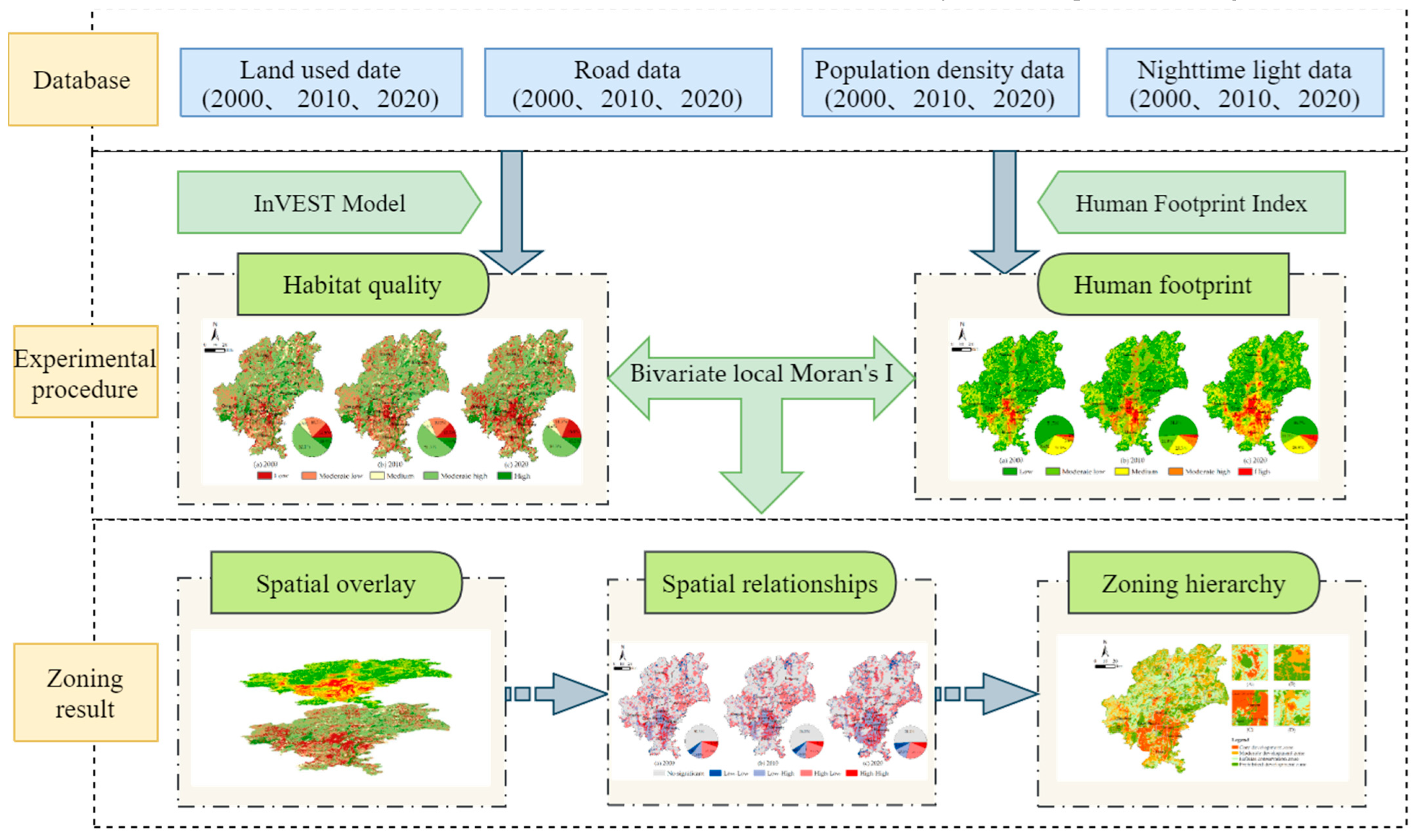
The overall research framework of this study can be expressed as Figure 2:
Firstly, the spatial patterns of HQ in Guiyang city in 2000, 2010 and 2020 were calculated by using the HQ model based on land use data. Secondly, the spatial patterns of HF in Guiyang city in 2000, 2010 and 2020 were measured by HFI according to land use data, population density data, night time light data and road data were used in the process. Then, the spatial relationships between HQ and HF in Guiyang city were simulated based on the bivariate local Moran’s I.
The results of these two steps were used as the basis for zoning in which the ecological protection was prioritized. Finally, the territorial space of Guiyang city was divided into four zones: the core development zone, the moderate development zone, the habitat conservation zone and the prohibited development zone (the detailed zoning scheme is described in Section 2.3.6).

2.3.2. The Habitat Quality Model

The HQ model in the InVEST software can be used to evaluate the ecosystem status. There are four key factors in this model [39]: (1) the relative impact of each threat; (2) the relative sensitivity of each habitat to each threat; (3) the distance between the habitat and the source of the threat; and (4) the extent to which the land is protected by law [49]. The HQ index is calculated by the following formula [40]:
Q x j = H j [ 1 ( D x j z D x j z + K z ) ]  
where Qxj represents the HQ of grid x in land use type j; Hj represents the habitat suitability of land use type j; Dxj represents the threat level of grid x in land use type j; k represents the half-saturation constant; and z = 2.5. The threat level Dxj is calculated by the following formula:
D x j = r = 1 R y = 1 Y r ( w r r = 1 R w r ) r y i r x y β x S j r  
where Dxj represents the habitat degradation or threat level in grid x; r represents the threat factor; y represents the total number of threat grids in r; Yr represents the number of threat grids in r; wr represents the weight of each threat factor r; ry represents the threat factor value of grid y; irxy represents the impact of threat r in raster y to habitat x; βx represents the level of accessibility of grid x; and Sjr represents the sensitivity of land use type j to threat factor r. irxy is calculated by the following formula:
i r x y = { 1 d x y d r m a x         ( l i n e a r ) e x p [ 2.99 d r m a x d x y ] ( e x p o n e n t i a l )
where dxy represents the linear distance between grids x and y, and drmax represents the maximum sufficient distance of threat factor r.
In this study, based on the actual situation in the study area, paddy field, arid land, urban land, rural settlements, other construction land and unused land were used as threat factors. Furthermore, the maximum influence distance and weight of the threat factors, the habitat suitability of different land use types (values range from 0 to 1, with higher values indicating higher habitat quality), and the relative sensitivity of different land use types to different threat factors (Table 2 and Table 3) were determined with reference to previous studies [50,51]. The spatial distribution of the HQ in Guiyang city was obtained by substituting the relevant parameters into the HQ model of InVEST.

2.3.3. Human Footprint Index (HFI)

HF reflects the influence of human activities on the land surface [9]. In this study, HFI was used to measure the regional HF in the study area. The indicators developed by Sanderson et al. including population density, land transformation, transportation accessibility, and power infrastructure was applied [15]. Of note, because the rivers in Guiyang city had no transportation function, the indicator on transportation accessibility was represented by roads. The specific formula for calculating the HFI is as follows:
H F I = L U I + P O P + N T L + R O A D  
where LUI represents the land use index, POP represents the population density, NTL represents the night time light index, and ROAD represents the traffic accessibility degree after assigning the value for quantification. Depending on the pressure of these indicators on the ecological impact, pressure scores from 0 to 10 were assigned in different ways, and the final HFI was obtained after comprehensive superposition. The specific assignment of pressure scores is as follows:
(1) Land use type can obviously express the results from the impact of human activities on the earth’s surface. One kind of the ecological degradation is the reduction of ecological land by anthropogenic disturbance. It is confirmed that the area with more intensity of human activities, for instance urban areas, have more hindering effect on ecosystem [52]. Therefore, the pressure score of urban land and other construction land was set as 10, meanwhile the pressure score of rural settlements was assigned 8 because it has less effect on ecosystem than urban land [16,53]. In addition, the paddy field and arid land were given 7 points. Notably, the forests, grasslands, and waters, were given 1 point instead of 0, as human activity still occurs in these areas.
(2) Many of the pressures humans exert on the environment are close to where they are located [54]. Population density directly reflects the intensity of human activities, yet, there might be human activities in the areas with tiny population density. Using natural breakpoints method in ArcGIS10.2 software, the population density was divided into ten levels and the pressure scores of these levels ranged between 1 and 10.
(3) Night time light precisely describes the population distribution and human activities in nighttime, which has been widely utilized in many researches, e.g., GDP, urban expansion, and energy consumption [55]. However, unlike the population density index, we gave a score of 0 with digital number (DN) values of 0 [19], and the rest were given 1–10 points according to the natural break point method. The pressure score of night time light with the digital number (DN) value equal to zero was set to 0. Subsequently, the DN values higher than 0 were separated into ten levels, each with a 1 increment. Of the ten levels, Level 1 was set as 0 and Level 11 was equal to 10.
(4) As a channel of human access to nature, roads directly affect the integrity of the natural landscape pattern and the habitat of animals In a great number of relevant researches, roads were perceived as an influencing factor from human to ecosystem [56]. In this paper, roads and railways adopted multiple ring buffer zones for scoring. However, due to the different ways and degrees of environmental impact of railroads and roads [19], we adopted different schemes to address it. Among them, the pressure scores of areas within 0 km to 0.5 km of a railroad were assigned 8, those within 0.5 km to 2 km were assigned a score of 6, those within 2 km to 5 km were assigned a score of 4, and those areas beyond 5km were assigned a score of 0. Areas within 0 km to 0.5 km of a road were assigned a score of 8, areas within 0.5 km to 2 km were assigned a score of 6, areas within 2 km to 5 km were assigned a score of 4, areas within 5 km to 10 km were assigned a score of 2, and areas beyond 10 km were assigned a score of 0.
Finally, all the data were uniformly pre-processed and equal weighted superimposed to obtain the HF in Guiyang city.

2.3.4. Global Moran’s I

The global Moran’s I can be used to measure a spatial correlation between independent and dependent variables [57]. In this paper, it was used to identify the spatial correlation between HQ and HF. The specific formula of global Moran’s I is as follows:
I = n i = 1 n j = 1 n W i j ( X i X ) ( X j X ) i = 1 n j = 1 n W i j ( X i X ) 2
where I is the global Moran’s I index value, and the value ranges [−1, 1]. If Moran’s I index value > 0, there is a positive spatial correlation between variables. Conversely, if Moran’s I index value < 0, there is a negative spatial correlation between variables, and the larger the index value is, the greater the regional correlation.

2.3.5. Bivariate Local Moran’s I

The bivariate local Moran’s I, as an effective method in geographical and ecological research, can offset the limitation of previous spatial autocorrelation analyses with only one variable [57,58]. It can be used to observe the value of one variable of a spatial unit and the value of another variable of an adjacent spatial unit in order to reveal the interrelationships between the two functional systems. The spatial relationship between HQ and HF was measured by the bivariate local Moran’s I in this study. The formula of bivariate local Moran’s I is as follows:
I = x i k x ¯ k σ k j = 1 n [ W i j x j I x ¯ I σ I ]
where I is the bivariate local Moran’s I spatial autocorrelation coefficient; represents the k-th functional value of the i-th unit; represents the I-th functional value of the k-th unit; represent the average value of the k-th function and I-th function, respectively; represent the variance in the k-th function and I-th function; n represents the number of units in the study area; and wij represents the spatial adjacent weight matrix between units i and j in the study area. The queen neighbour mode was used to construct spatial weights and jointly analyse the HQ and HF based on the 95% confidence level to obtain the final spatial relationship. If the result had “high-high” significant spatial clustering, it indicated that both HQ and HF had high values in the region. Conversely, if the result had “low-low” significant spatial clustering, it meant that HQ and HF had low values in the region. Moreover, if the result was “high-low” or “low-high” significant spatial clustering, it illustrated that HQ and HF were high in one value and low in the other in the region.
Considering the scale of the study area, the data, used in bivariate local Moran’s I, was converted into grids with cell sizes of 100 m × 100 m.

2.3.6. Zoning Management Scheme

Zoning management of territorial space is an important measure to improve the overall efficiency of land use and promote regional sustainable development [59]. In this study, according to the result of the spatial relationship between HQ and HF, four zones, namely the core development zone, the moderate development zone, the habitat conservation zone and the prohibited development zone, were identified (Figure 3).
Specifically, the prohibited development zone included the area with “high-low” relationship and “high-high” relationship between HQ and HF, and then in order to Consistent with the Delineation Scheme of Ecological Protection Red Line in Guizhou Province announced in 2018, the prohibited development zone was adjusted based on the ecological red lines of Guiyang city. The area with “low-high” relationship was designated as the development core zone because the land use of this area was largely urban construction land, and this zone will take up important tasks for the economic and social development of Guiyang city. The areas with “not insignificant” relationship and “lowlow” relationship were separated into the moderate development zone and the habitat conservation zone. That is, if the HQ value was greater than the HF value, then this spatial unit was classified as the habitat conservation zone, otherwise it is classified as the moderate development zone.

3. Results

3.1. Spatio-Temporal Patterns of Habitat Quality

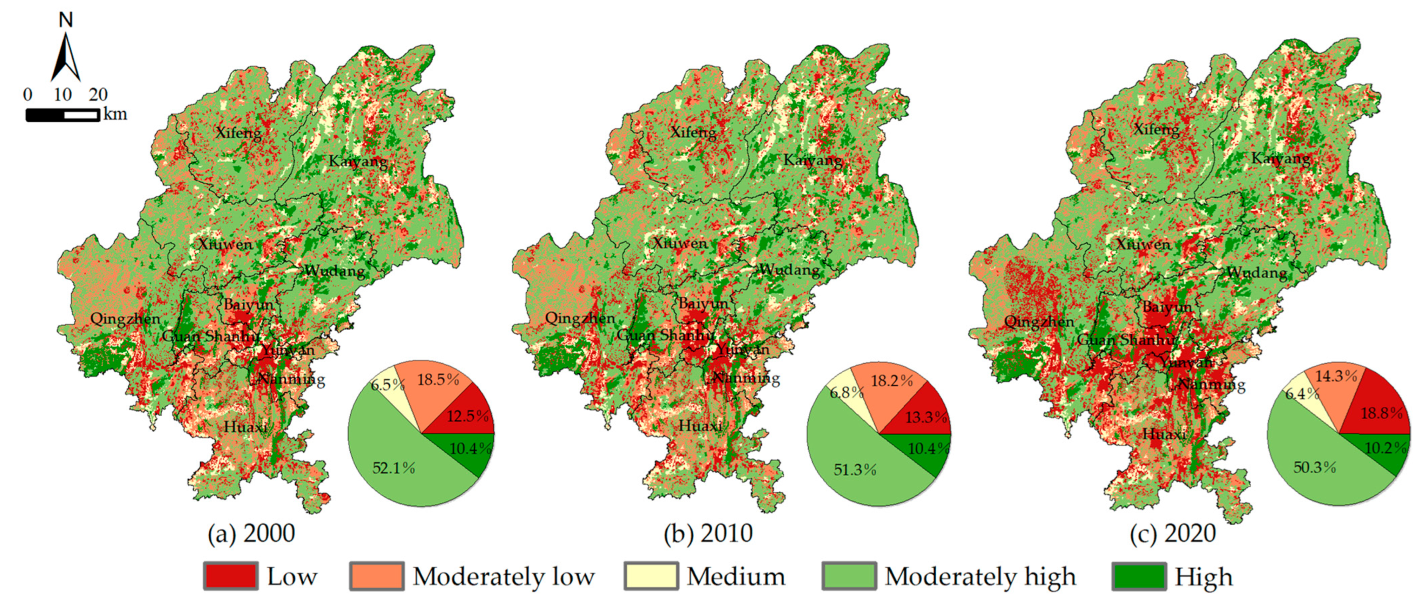
Based on the HQ model of InVEST, the HQ results of Guiyang city in 2000, 2010 and 2020 were obtained (Figure 4). The HQ was divided into five grades: low [0, 0.2), moderately low [0.2, 0.4), medium [0.4, 0.6), moderately high [0.6, 0.8), and high [0.8, 1]).
The HQ of Guiyang city in 2000, 2010, and 2020 mainly concentrated on moderately high and high, with the total areas of both grades accounting for more than 60%, indicating that the overall ecological quality of Guiyang city was superior. The spatial distributions of HQ were characterized by spatial agglomeration, and the high-value areas were scattered at the junction of county-level regions. Among them, the northern regions of Guiyang city were greatly affected by the topography and location, where there were large areas of woodland. Moreover, the southeastern regions, i.e. the south of Qingzhen and the west of Guanshanhu, had large area with high HQ due to the impact of water-bodies. On the contrary, the low HQ were principally located in the southern regions, including Baiyun, Guanshanhu, Yunyan, Nanming and Huaxi, which were the core urban areas of Guiyang city and had intense effects on ecosystem.
The values of HQ in Guiyang city have varied significantly from 2000 to 2020. To explore the characteristics of HQ changes in Guiyang city, Origin 2021 software was used to create a chord diagram (Figure 5), which not only can clearly exhibit the magnitude of changes in each HQ grade, but also can visually express the direction of area flow between each HQ grade. Combining with Figure 4 and Figure 5, it is unveiled that the area variety of each grade of HQ from 2000 to 2010 were relatively small, and there was little transfor-mation between them. However, from 2010 to 2020, the level of urbanization and indus-trialization in Guiyang city has accelerated significantly, resulting in significant changes in each grade of HQ. Particularly, the area with low HQ climbed from 13.3% in 2010 to 18.8% in 2020, while the others revealed a downwards trend in HQ. In general, over the past 20 years, the areas with medium HQ, moderately high HQ, and high HQ have less change, on the contrary, the area with low HQ has the most change. It is noticeable that the increment of area with low HQ was derived from the transformation of moderately low HQ due to the growing intensity of land use in the suburban areas and the urban expansion.
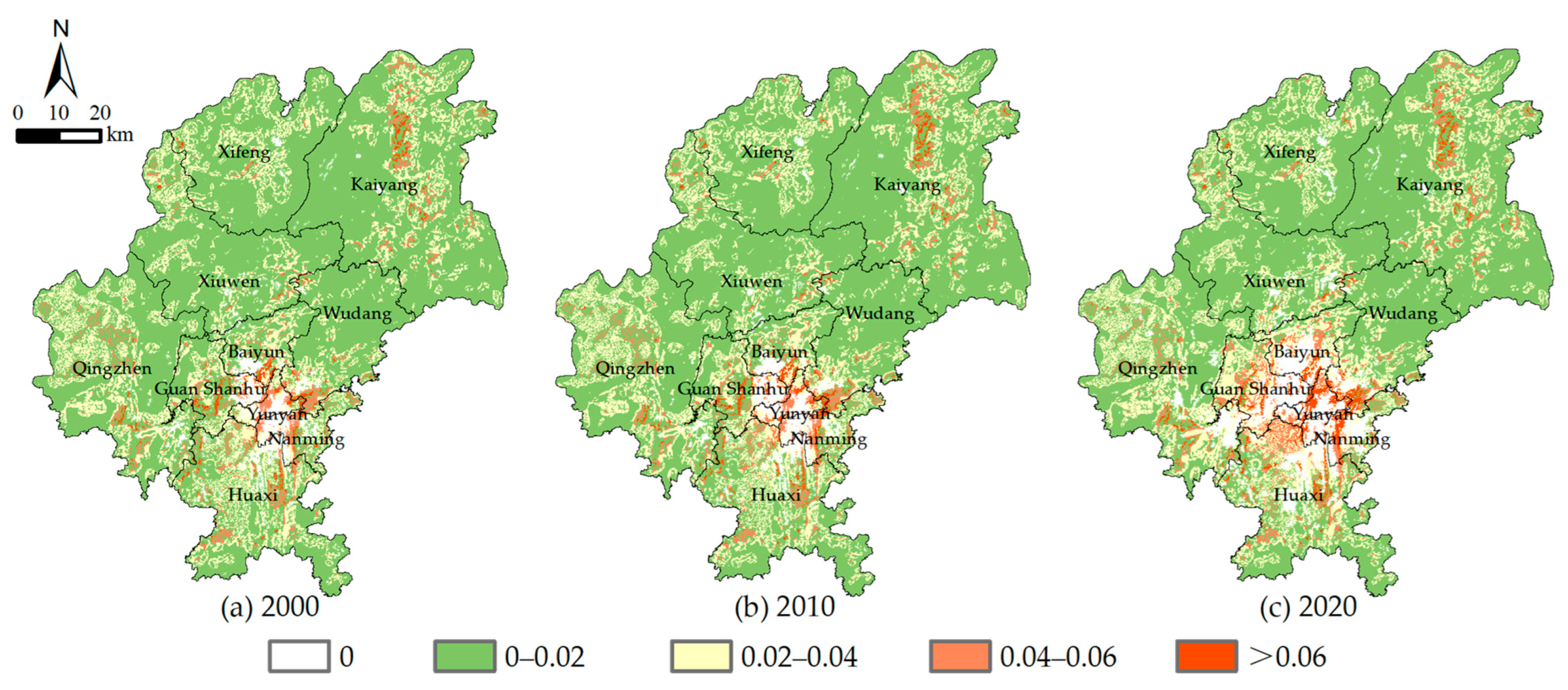
The spatial distribution of habitat quality degradation in Guiyang from 2000 to 2020 were shown in Figure 6, which can further support the results shown in Figure 4. The areas with a high degradation were mostly located in the main urban areas of southern Guiyang city, with obvious ring characteristics, indicating that the HQ degradation in Guiyang city was primarily dominated by urban construction land expansion (the areas with HQ degradation equal to 0 were predominantly urban construction land). Addition-ally, the HQ degradation in the remaining areas was relatively low and the degree of deg-radation was exhibited a downwards trend from urban to suburban areas. Therefore, it can be exposed that the overall development of Guiyang city was sustainable.

3.2. Spatio-Temporal Patterns of Human Footprint

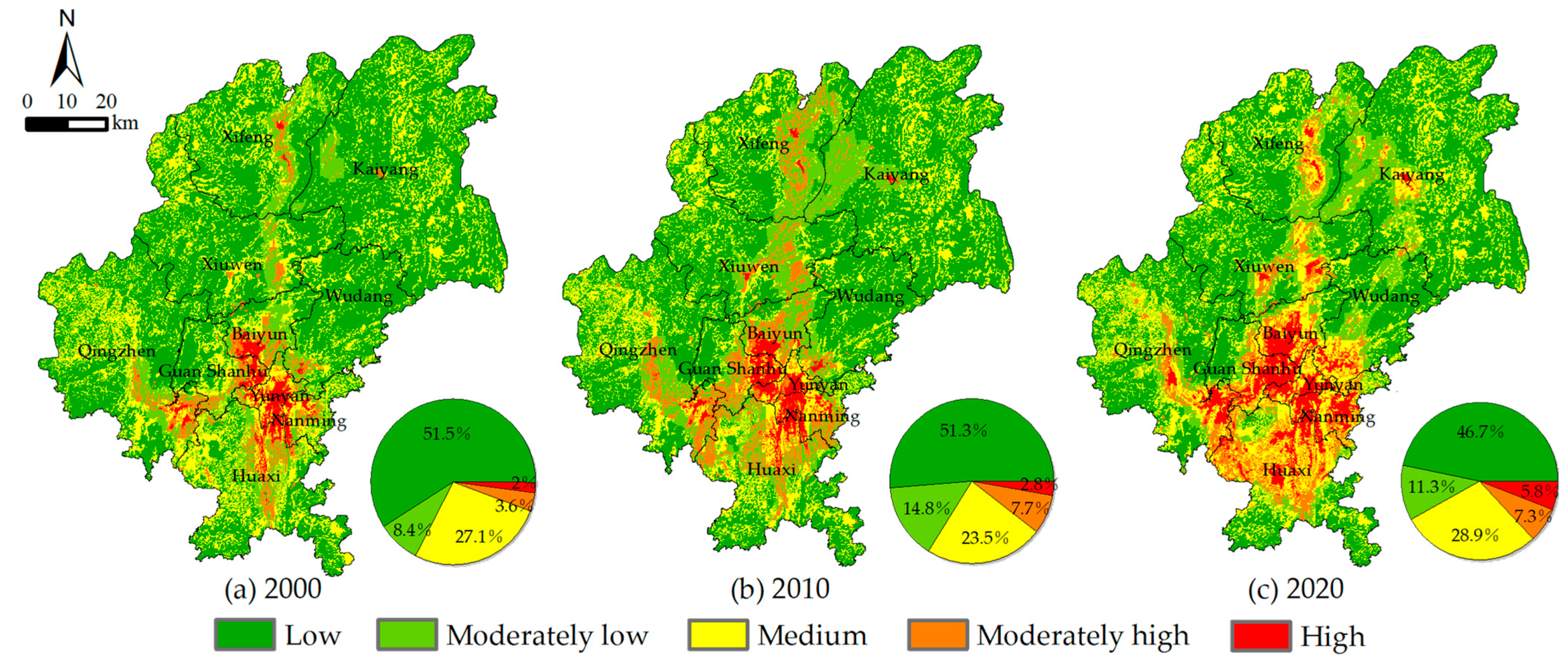
The results of HF in Guiyang city in 2000, 2010 and 2020 were shown in Figure 7. The results were divided into five grades: low [0, 0.2), moderately low [0.2, 0.4), medium [0.4, 0.6), moderately high [0.6, 0.8), high [0.8, 1].
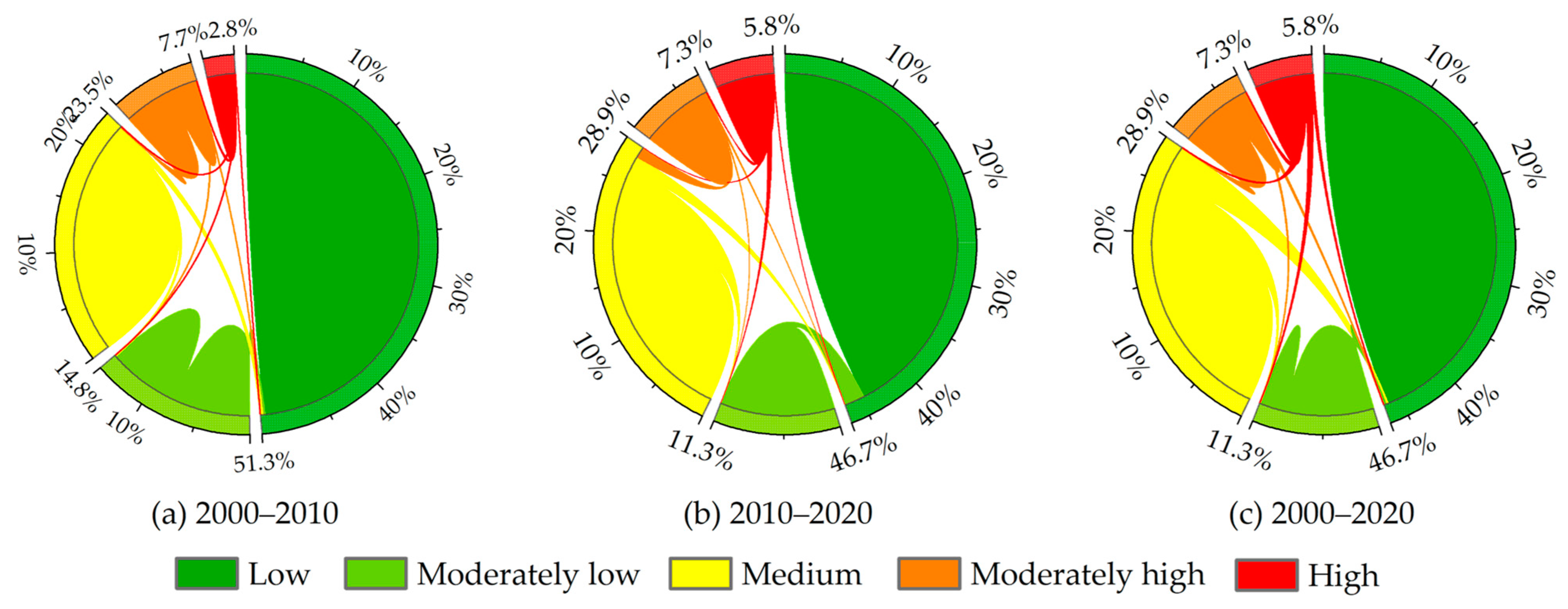
The spatial distribution of HF in Guiyang city had a strong agglomeration; that is, the areas with high HF were mainly concentrated in the main urban areas in the southern part of Guiyang city where the high value of HF spread outwards during the study period. Meanwhile, in the northern part, i.e., Xifeng and Kaiyang, the spatial distribution of high HF became wider and gradually extended to the central area. Obviously, the distributions of medium and low HF were scattered in Qingzhen, Xiuwen, Xifeng, Kaiyang and Wudang due to the landscape fragmentation. This result expressed that the karst landscape had the obstacle to human activities. Furthermore, as shown in Figure 7, more than 50% of the total area were low HF in 2000 and 2010, but this value fell to 46.7% in 2020. On the contrary, although the percentage in area of high HF was smallest, with 2%, 2.8% and 5.8% in 2000, 2010 and 2020, respectively, the dramatic change occurred during the latter period, rising 3%. The percentage in area of moderately high HF experienced sharp increment from 3.6% to 7.7% from 2000 to 2010, but remained stable from 2010 to 2020. Of note, the percentage in area of medium grade had minor changed, decreasing less than 4% from 2000 to 2010 and raising more than 5% from 2010 to 2020.
During the study period, the HF in Guiyang city has changed significantly. The rapid urbanization and the construction of roads have greatly increased the area and intensity of human activities. Figure 8 showed the rate and direction of change in HF area for each grade from 2000 to 2020. The proportion of high HF areas expanded from 2.8% in 2000 to 5.8% in 2020, which primarily stemmed from the areas with low HF and moderately low HF. At the same time, the proportion of low HF decreased from 51.5% in 2000 to 46.7% in 2020, and such area greatly shifted to the medium HF. Overall, the range and magnitude of change in the HF of Guiyang City between 2010 and 2020 was significantly greater than that between 2000 and 2010.

3.3. Spatio-Temporal Relationships between Habitat Quality and Human Footprint

Based on the global spatial Moran’s I index, the spatial autocorrelation relationships between HQ and HF in Guiyang city were obtained. The Moran’s I index values were −0.278, −0.297, and −0.360 in 2000, 2010, and 2020, respectively, explaining a significant negative spatial correlation between them. This negative correlation increased over time, indicating that the impact of human activities on the ecological environment has continued to increase.
At the 95% confidence level, based on the bivariate local Moran’s I, the spatial relationships between HQ and HF and their area proportion in Guiyang from 2000 to 2020 were obtained (Figure 9). Among them, the area of “low-low” represented the areas with low HQ and low HF; “low-high” indicated the areas with low HQ but high HF; “high-low” meant the areas with high HQ but low HF; “high-high” denoted theareas with high HQ and high HF; and “not significant” implied that the relationship between HQ and HF was not significant at a 95% confidence level.
In the field of the spatial distribution, except the areas with no significant correlation, the spatial relationship between HQ and HF in Guiyang city greatly concentrated on the “low-high” and “high-low”.The area of “low-high” was mostly scattered in the southern region of Guiyang city, accounting for 10.8%, 10.8%, and 13.3% of the total area in 2000, 2010 and 2020, respectively. Meanwhile, the “high-low” area primarily dominated the junction of northern districts and counties, accounting for 19.8%, 20.7%, and 23.1% of the total area in 2000, 2010 and 2020. It should be noted that both the area with “low-high” and “high-low” enlarged during the study period. On the one hand, the rapid urbaniza-tion in the south has accelerated the area of human activities, resulting in a growing “low-high” area. On the other hand, the area with “high-low” was also rising due to the imple-mentation of strict ecological protection and restoration policies. In addition, with limited distribution, the “high-high” was chiefly scattered in the edge or interior of the “low-high” which was dominated by urban suburbs or urban parks. The spatial distribution of “low-low” and “high-high” was small in the study area. Among them, the “low-low” area was principally spread in the northern part of Guiyang City, where soil erosion and rock desertification affected a large area. The “high-high” area mostly covered suburban or inner-city areas, which were influenced by high intensity of human activities and urban green spaces

3.4. Spatial Zoning Results for Guiyang City

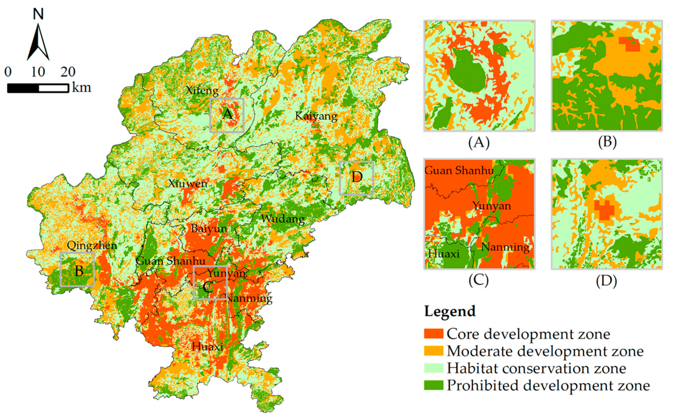
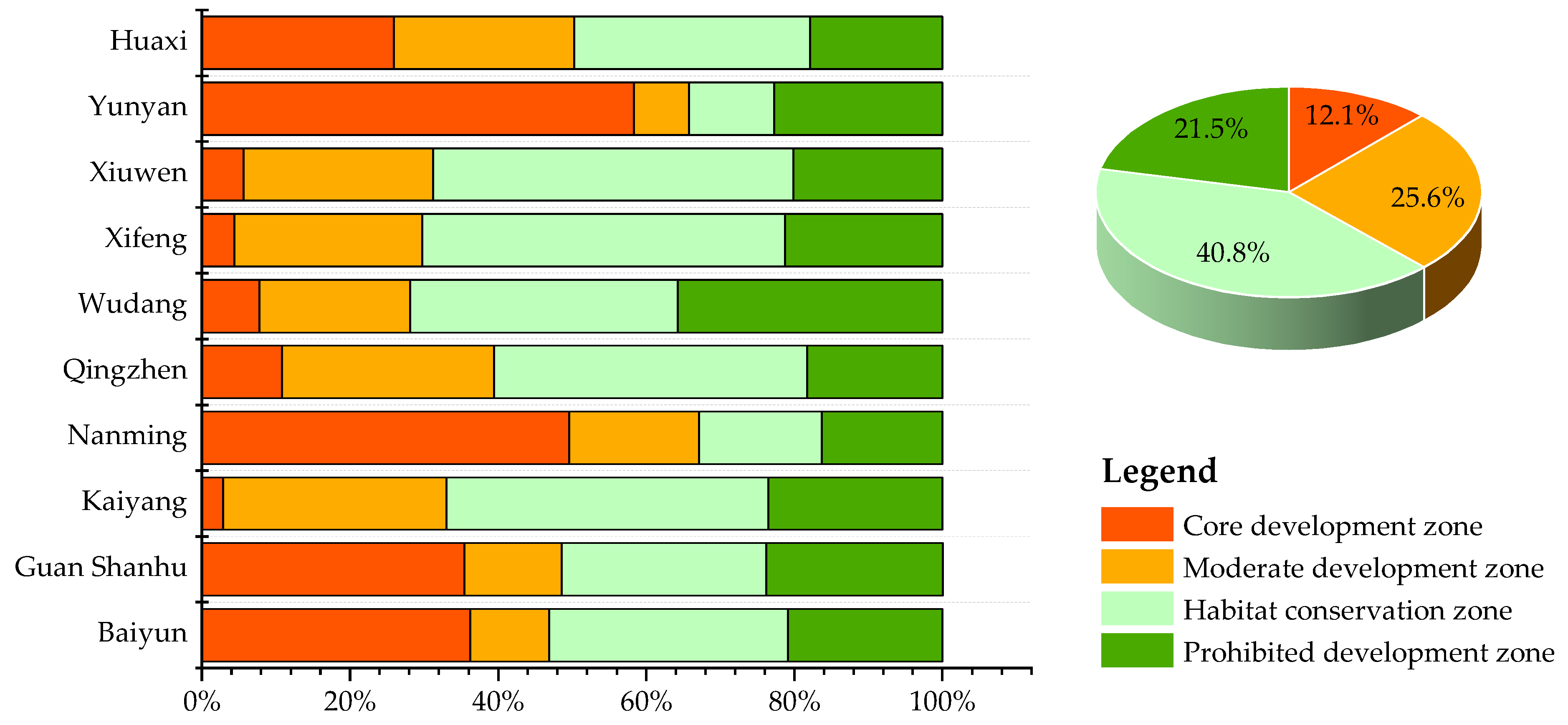
Based on the zoning scheme, the spatial zoning results of Guiyang city were obtained and analysed from the whole region and county (district or city) scale (Figure 10 and Figure 11).
Among these zones, the core development zone accounted for the smallest proportion, with only 12.1% of the total area, but beared most of the population and economic output of Guiyang city. From the perspective of spatial distribution, the core development zone presented a spatial distribution pattern of “one main core and multiple subcentres”. “One main core” implied annular distribution characteristics, and located in the southern area of Guiyang city, including Huaxi, Yunyan, Nanming, Guanshanhu and Baiyun. “Multiple subcentres”, referring to the central area of the northern regions, was occupied by the core development zones. Such areas could be developed as the core of economy and society of the county-level regions. Overall, the core development zone will be the main areas of economic development and population agglomeration in Guiyang city in the future, and human activities will continue to be enhanced
The moderate development zone was chiefly distributed in the periphery of the core development zone and surrounded by the habitat conservation zone. This zone generally accounted for 25.6% of the total area and the larger area covered Huaxi, Xiuwen, Xifeng, Wudang, Qingzhen and Kaiyang. The HF was relatively high in the moderate develop-ment zone, where the main land use types were principally construction land, agricultural land and ecological land such as woodland and grassland. The moderate development zone undertook the important tasks of regional grain production, industrial development and provided reserve land resources for future urban sprawl.
The habitat conservation zone had largest area, accounting for 40.8% of the total area, and dominated the west and north of Guiyang city. At the county-level scale, Kaiyang, Xifeng, Xiuwen and Qingzhen had large distribution, accounting for approximately 50% of the area of these zones. Such zone was generally composed of shrub land, grassland and other land types with high ecological value, which provided diverse ecosystem services.
The prohibited development zone accounting for 21.5% of the total area, was located in the junction areas of county-level regions, and the largest distribution area dominated Wudang, accounting for nearly 40% of the total area. Owing to rural areas, this area was occupied by forest land and rarely affected by human activities. In addition, waterbodies and wetland, for instance Guanshanhu Lake, Hongfeng Lake and Huaxi River, had become an important part of such zone, benefited from a series of strict measures for water protection.

4. Discussion

4.1. Effects of Human Activities on Habitat Quality

With the rapid development of globalization and urbanization, human footprint seems to directly affect more than 77% of the earth’s surface except Antarctica [60]. Both status and quality of ecosystem have been greatly damaged due to human activities and this impact has been gradually increasing [61].
The spatial diversities between social and economic development determine the intensity of human influence on the regional natural environment, at the same time, HQ has altered in response to customer demand [24]. During the past two decades, Guiyang has gained remarkable achievements in economic and social development, for instance, the population increasing from 3.718 million in 2000 to 5.987 million in 2020, the area of construction land rising from 230 km2 to 360 km2, and the GDP soaring from 26.48 billion to 431.17 billion. Rapid urbanization occupied a large amount of cultivated land and grassland, leading to the drop of HQ [62]. In addition, the improvement of road network promoted the access to external trade, as well as the development of secondary and tertiary industries, nevertheless, made it possible to exacerbate the anthropogenic disturbance to ecosystem [56]. In this study, it is unveiled that more than 40% of the total area in Guiyang city were affected by medium or higher HF, and this proportion was expanding. The area with lowHF was less than 50% of the total area, dominating the southern regions, which directly gave rise to poor HQ in Guiyang city. In terms of the spatial relationship between HQ and HF, the areas with “low-high” type have constantly spread during the study period, suggesting that human activity is increasingly damaging habitat quality in Guiyang city.
Although the incremental impact of human activities on ecosystem originates from the demand for population growth, such as, food, residence and energy consumption [28], numerous researches demonstrate that a series of policies for ecological protection have produced markable performances to improve ecosystem [63,64]. For example, Li et al. exposed that the implementation of ecological engineering projects and protection policies in Tibet has resulted in human activities intensity decreased by 16.1% from 2000 to 2017 [65]. Chen et al. discussed that land use management can greatly improve the ecological environment. The governments of China and India have significantly increased the global green leaf area over the last decade or so through the restoration of forests and extensive farmland cultivation [66]. In addition, Torres-Rojo et al. and Wang et al. have shown that appropriate ecological measures can not only contribute to the improvement of the regional ecological environment but also help to alleviate regional poverty problems [67,68]. Hence, it is of great significance for governments at all levels to formulate appropriate strategies to guide human activities and protect ecosystem.

4.2. Implications for the Development of Guiyang City

As the capital of Guizhou Province, Guiyang city has inevitably experienced urban sprawl and population explosion, and thus the ecosystem must respond to these challenges. However, owing to lack of opportune self-regulation, sustainable planning is essential to support long-term development of ecosystem. According to the characteristics of HQ and HF in various regions of Guiyang city, four categories of spatial zones were separated in which differentiated strategies should be adopted. Different from rural areas, both the green space and blue space, as the most fundamental elements in urban ecosystems, are crucial to promote the integrity of ecosystems between urban and rural area, and improve the quality of life for urban residents [69,70]. Benefiting from a mosaic of mountains, waterbodies, woods and urban land, Guiyang has an innate advantage in optimizing the urban ecosystem. In the process of optimization, it is critical to pay more attention to urban green space in the core development zone. Accordingly, the projects of “management of a hundred mountains” and “city of a thousand parks” in Guiyang, aiming to construct a green space system in urban area with “mountains as the barrier, water as the pulse, roads as the corridor, and gardens as the core”, have played an important role in enhancing the amount of green space. Since the implementation of these projects, the per capita green area of Guiyang city increased by 2 m2.
However, Guiyang is the core to advance Guizhou Province, and measures such as improving infrastructure, expanding urban areas and absorbing population are an important part of the strategy of “strengthening provincial capital” in 2021, but will undoubtedly increase the pressure on the urban ecosystem. When land resources are insufficient for urban sprawl, the moderate development zone can provide efficient space for urban sprawl while avoiding excessive encroachment on other lands. Nevertheless, it is noticeable that there were a large amount of farmlands in the moderate development zone, and therefore the measures for farmland protection should be proposed to ensuring food security [71].
As the barrier to prohibited development zone, appropriate policies and laws should be established to reasonably protect the habitat conservation zone, and only the low intensity of human activities should be allowed in these zone. There were a large amount of rural settlements and agricultural lands in the habitat conservation zone, in that case, agricultural development, tourism development and other activities should be carried out without destroying the corresponding ecological functions [72]. In addition, the habitat conservation zone were predominant in the northern part of Guiyang city, where the ecosystem suffered from serious rocky desertification and soil erosion [73]. Therefore, measures to control rocky desertification and soil erosion should be implemented in these areas to reduce the habitat degradation.
The prohibited development zone was a type of the most important systems to maintain regional ecological security and provide habitat for wildlife. Similar to the prohibited development zone in other countries in the world, the prohibited development zones of Guiyang should be protected by strict policies and laws [41,74]. For example, the Huaxi Wetland Park, Guanshanhu Park and Qianling Mountain Park provided superior habitats for a large number of rare animals, and measures to prohibit from developing land and hunting should be enforced in these areas. As Hongfeng Lake and Huaxi Reservoir were important water sources in Guiyang, activities that may cause pollution should be forbidden in these areas, and severe penalties should be established to reduce these activities by governments or organizations.

4.3. Limitations of Uncertainty and Future Recommended Work

Some limitations of this study should be noted here: (1) Due to the availability of data, some indicators of human footprint were extracted from the data with low resolution, thus affecting the value of HF. For instance, owing to lack of relatively high-resolution road data, only the impact of trunk roads on human activities was used for this research and the impact of the secondary roads was ignored. (2) Because the existing human footprint indicators cannot include all human activities, the range and intensity of the human footprint assessment was less accuracy than the actual situation. (3) Spatio-temporal analysis of HQ and HF was limited to the past and lacks scenario prediction for the future. Yet, the framework of this research can still serve as guidance for urban managers and may shine some light for subsequent scholars to conduct research on human activities or habitat quality.
In future studies, more attention should be given to data in order to obtain more accurate results. In addition, indicators should be selected appropriately for the actual situation in the study area to facilitate better use of research results. Related studies can focus on future scenario projections and mechanism studies.

5. Conclusions

In this study, the HQ model of InVEST was used to measure the spatial patterns of HQ in Guiyang city from 2000 to 2020, and the parameters were set based on the study area. Moreover, a classical model for studying human activities, namely HFI, was used to assess the spatial patterns of HF in Guiyang city from 2000 to 2020. According to the results of HQ and HF, the bivariate local Moran’s I was applied to simulate the spatial and temporal relationships between them and the four spatial zones, i.e., the core development zone, the moderate development zone, the habitat conservation zone and the prohibited development zone, were determined to guide the urban development of Guiyang city.
The results expressed that the values of HQ in Guiyang city during the past two decades were primarily dominated by the moderately high and high grades, accounting for more than 60% of the total area, and mostly located at the junctions among the county-level regions. The proportion of the low HQ area grew from 12.5% in 2000 to 18.5% in 2020, which was triggered by the urban development.
Meanwhile, human activities in Guiyang city have changed dramatically, with the percentage in area of low HF fell from 51.5% in 2000 to 46.7% in 2020, while the percentage of high HF soared from 2% to 5.8%. The spatial distribution of HF in Guiyang city was largely characterized by low values in the north and high values in the south, and some areas of high-value were influenced by roads and show a band-like distribution.
Besides, the spatial correlation between HQ and HF in Guiyang city was significantly negative from 2000 to 2020, with higher percentage in area of “low-high” and “high-low” On the one hand, it was apparent that the spatial distribution of “low-high” spread from the southern main urban area to the surrounding area, indicating that the impact of human activities on the ecosystem has strengthened. On the other hand, the spatial distribution of the “high-low” relationship expanded, espetially in Xiuwen, Xifeng, and Kaiyang, which was stemmed from the improvement of ecosystem, such as returning farmland to forest and controlling rock desertification.
Importantly, four spatial zones, that is, the core development zone, the moderate development zone, the habitat conservation zone and the prohibited development zone, were identified. The core development zone accounted for the smallest proportion, with only 12.1% of the total area, and largely covered the southern area of Guiyang city. The moderate development zone accounting for 25.6% of the total area, occupied most area of Huaxi, Xiuwen, Xifeng, Wudang, Qingzhen and Kaiyang. The habitat conservation zone accounting for 40.8% of the total area, was mainly scattered in the western and northern parts of Guiyang. The prohibited development zone accounting for 21.5% dominated the intersection areas of county-level regions. Corresponding development strategies were proposed according to the characteristics of each zone to promote the sustainable development of Guiyang city. For instance, it is critical to pay more attention to urban green space in the core development zone. The moderate development zone is used to provide space for urban sprawl while avoiding excessive encroachment on other lands and protecting agricultural land. Appropriate policies and laws should be developed to protect the habitat conservation zone and control rock desertification and soil erosion. The prohibited development zone should be protected to reduce the impact of human activities by strict policies and laws.

Author Contributions

S.G. conceived and designed the experiments; S.G. performed the experiments; S.G. and L.Y. wrote the paper; and L.Y. and H.J. helped with editing. All authors have read and agreed to the published version of the manuscript.

Funding

This research was funded by the “Rural spatial restructuring in poverty-stricken mountainous areas of Guizhou based on spatial equity: A case study of the Dianqiangui Rocky Desertification Area” project of the National Natural Science Foundation of China, grant number 41861038, and the “Research and Development of Emergency Response and Collaborative Command System with Holographic Perception of Traffic Network Disaster” project of the National Key Research and Development Program, grant number 2020YFC1512002.

Institutional Review Board Statement

Not applicable.

Informed Consent Statement

Not applicable.

Data Availability Statement

Not applicable.

Conflicts of Interest

The authors declare no conflict of interest.

References

  1. Bloom, D.E.; Canning, D.; Fink, G. Urbanization and the Wealth of Nations. Science 2008, 319, 772–775. [Google Scholar] [CrossRef] [PubMed] [Green Version]
  2. Liu, Z.; Gan, X.; Dai, W.; Huang, Y. Construction of an Ecological Security Pattern and the Evaluation of Corridor Priority Based on ESV and the “Importance–Connectivity” Index: A Case Study of Sichuan Province, China. Sustainability 2022, 14, 3985. [Google Scholar] [CrossRef]
  3. Fischer, J.; Lindenmayer, D.B. Landscape modification and habitat fragmentation: A synthesis. Glob. Ecol. Biogeogr. 2007, 16, 265–280. [Google Scholar] [CrossRef]
  4. Li, Z.-T.; Li, M.; Xia, B.-C. Spatio-temporal dynamics of ecological security pattern of the Pearl River Delta urban agglomeration based on LUCC simulation. Ecol. Indic. 2020, 114, 106319. [Google Scholar] [CrossRef]
  5. McAtee, J.W.; Drawe, D.L. Human impact on beach and foredune microclimate on North Padre Island, Texas. Environ. Manag. 1981, 5, 121–134. [Google Scholar] [CrossRef]
  6. Zhang, Y.; Song, W.; Fu, S.; Yang, D. Decoupling of land use intensity and ecological environment in Gansu province, China. Sustainability 2020, 12, 2779. [Google Scholar] [CrossRef] [Green Version]
  7. Liu, Y.; Fang, F.; Li, Y. Key issues of land use in China and implications for policy making. Land Use Policy 2014, 40, 6–12. [Google Scholar] [CrossRef]
  8. Peng, J.; Lv, D.; Dong, J.; Liu, Y.; Liu, Q.; Li, B. Processes coupling and spatial integration: Characterizing ecological restoration of territorial space in view of landscape ecology. J. Nat. Resour. 2020, 35, 3–13. [Google Scholar]
  9. Xu, Y.; Xu, X.; Tang, Q. Human activity intensity of land surface: Concept, methods and application in China. J. Geogr. Sci. 2016, 26, 1349–1361. [Google Scholar] [CrossRef]
  10. Duan, Q.L.; Luo, L.H. Summary and prospect of spatialization method of human activity intensity:taking the Qinghai-Tibet Plateau as an example. J. Glaciol. Geocryol. 2021, 43, 1582–1593. [Google Scholar]
  11. McCloskey, J.M.; Heather, S. A Reconnaissance-Level Inventory of the Amount of Wilderness Remaining in the World. Ambio 1989, 18, 221–227. [Google Scholar]
  12. Vitousek, P.M.; Ehrlich, P.R.; Ehrlich, A.H.; Matson, P.A. Human Appropriation of the Products of Photosynthesis. BioScience 1986, 36, 368–373. [Google Scholar] [CrossRef]
  13. Yang, F.; Matsushita, B.; Yang, W.; Fukushima, T. Mapping the human footprint from satellite measurements in Japan. ISPRS J. Photogramm. Remote Sens. 2014, 88, 80–90. [Google Scholar] [CrossRef]
  14. Mu, H.; Li, X.; Wen, Y.; Huang, J.; Du, P.; Su, W.; Miao, S.; Geng, M. A global record of annual terrestrial Human Footprint dataset from 2000 to 2018. Sci. Data 2022, 9, 1–9. [Google Scholar] [CrossRef] [PubMed]
  15. Sanderson, E.W.; Jaiteh, M.; Levy, M.A.; Redford, K.H.; Wannebo, A.V.; Woolmer, G. The Human Footprint and the Last of the Wild: The human footprint is a global map of human influence on the land surface, which suggests that human beings are stewards of nature, whether we like it or not. BioScience 2002, 52, 891–904. [Google Scholar] [CrossRef] [Green Version]
  16. Khelifa, R.; Mahdjoub, H.; Samways, M.J. Combined climatic and anthropogenic stress threaten resilience of important wetland sites in an arid region. Sci Total Environ. 2022, 806, 150806. [Google Scholar] [CrossRef]
  17. González-Abraham, C.; Ezcurra, E.; Garcillán, P.P.; Ortega-Rubio, A.; Kolb, M.; Bezaury Creel, J.E. The human footprint in Mexico: Physical geography and historical legacies. PLoS ONE 2015, 10, e0121203. [Google Scholar] [CrossRef] [Green Version]
  18. Jacobson, A.P.; Riggio, J.M.; Tait, A.; E. M. Baillie, J. Global areas of low human impact (‘Low Impact Areas’) and fragmentation of the natural world. Sci. Rep. 2019, 9, 14179. [Google Scholar] [CrossRef] [Green Version]
  19. Venter, O.; Sanderson, E.W.; Magrach, A.; Allan, J.R.; Beher, J.; Jones, K.R.; Possingham, H.P.; Laurance, W.F.; Wood, P.; Fekete, B.M. Global terrestrial Human Footprint maps for 1993 and 2009. Sci. Data 2016, 3, 1–10. [Google Scholar] [CrossRef] [Green Version]
  20. Li, S.; Zhang, Y.; Wang, Z.; Li, L. Mapping human influence intensity in the Tibetan Plateau for conservation of ecological service functions. Ecosyst. Serv. 2018, 30, 276–286. [Google Scholar] [CrossRef]
  21. Woolmer, G.; Trombulak, S.C.; Ray, J.C.; Doran, P.J.; Anderson, M.G.; Baldwin, R.F.; Morgan, A.; Sanderson, E.W. Rescaling the Human Footprint: A tool for conservation planning at an ecoregional scale. Landsc. Urban Plan. 2008, 87, 42–53. [Google Scholar] [CrossRef]
  22. Hall, L.S.; Krausman, P.R.; Morrison, M.L. The Habitat Concept and a Plea for Standard Terminology. Wildl. Soc. Bull. (1973–2006) 1997, 25, 173–182. [Google Scholar]
  23. Johnson, M.D. Measuring Habitat Quality: A Review. Condor 2007, 109, 489–504. [Google Scholar] [CrossRef]
  24. Bai, L.; Xiu, C.; Feng, X.; Liu, D. Influence of urbanization on regional habitat quality:a case study of Changchun City. Habitat Int. 2019, 93, 102042. [Google Scholar] [CrossRef]
  25. Hamada, S.; Ohta, T. Seasonal variations in the cooling effect of urban green areas on surrounding urban areas. Urban For. Urban Green. 2010, 9, 15–24. [Google Scholar] [CrossRef]
  26. Haase, D.; Nuissl, H. Does urban sprawl drive changes in the water balance and policy?: The case of Leipzig (Germany) 1870–2003. Landsc. Urban Plan. 2007, 80, 1–13. [Google Scholar] [CrossRef]
  27. Newbold, T.; Hudson, L.N.; Hill, S.L.; Contu, S.; Lysenko, I.; Senior, R.A.; Börger, L.; Bennett, D.J.; Choimes, A.; Collen, B. Global effects of land use on local terrestrial biodiversity. Nature 2015, 520, 45–50. [Google Scholar] [CrossRef] [Green Version]
  28. Williams, B.A.; Venter, O.; Allan, J.R.; Atkinson, S.C.; Rehbein, J.A.; Ward, M.; Di Marco, M.; Grantham, H.S.; Ervin, J.; Goetz, S.J.; et al. Change in Terrestrial Human Footprint Drives Continued Loss of Intact Ecosystems. One Earth 2020, 3, 371–382. [Google Scholar] [CrossRef]
  29. Lewis, N.S.; Fox, E.W.; DeWitt, T.H. Estimating the distribution of harvested estuarine bivalves with natural-history-based habitat suitability models. Estuar. Coast. Shelf Sci. 2019, 219, 453–472. [Google Scholar] [CrossRef]
  30. Zhang, H.; Sun, T.; Xue, S.; Yang, W.; Shao, D. Habitat-mediated, density-dependent dispersal strategies affecting spatial dynamics of populations in an anthropogenically-modified landscape. Sci. Total Environ. 2018, 625, 1510–1517. [Google Scholar] [CrossRef]
  31. Sannigrahi, S.; Chakraborti, S.; Joshi, P.K.; Keesstra, S.; Sen, S.; Paul, S.K.; Kreuter, U.; Sutton, P.C.; Jha, S.; Dang, K.B. Ecosystem service value assessment of a natural reserve region for strengthening protection and conservation. J. Environ. Manag. 2019, 244, 208–227. [Google Scholar] [CrossRef] [PubMed]
  32. Tianhong, L.; Wenkai, L.; Zhenghan, Q. Variations in ecosystem service value in response to land use changes in Shenzhen. Ecol. Econ. 2010, 69, 1427–1435. [Google Scholar] [CrossRef]
  33. Kong, L.; Zhang, L.; Zheng, H.; Xu, W.; Xiao, Y.; Ouyang, Z. Driving forces behind ecosystem spatial changes in the Yangtze River Basin. Acta Ecol. Sin. 2018, 38, 741–749. [Google Scholar]
  34. Dai, L.; Li, S.; Lewis, B.J.; Wu, J.; Yu, D.; Zhou, W.; Zhou, L.; Wu, S. The influence of land use change on the spatial–temporal variability of habitat quality between 1990 and 2010 in Northeast China. J. For. Res. 2019, 30, 2227–2236. [Google Scholar] [CrossRef]
  35. Feng, S.; Sun, R.; Chen, L. Spatio-temporal variability of habitat quality based on land use pattern change in Beijing. Acta Ecol. Sin. 2018, 38, 4167–4179. [Google Scholar]
  36. Berta Aneseyee, A.; Noszczyk, T.; Soromessa, T.; Elias, E. The InVEST Habitat Quality Model Associated with Land Use/Cover Changes: A Qualitative Case Study of the Winike Watershed in the Omo-Gibe Basin, Southwest Ethiopia. Remote Sens. 2020, 12, 1103. [Google Scholar] [CrossRef]
  37. Gao, Y.; Ma, L.; Liu, J.; Zhuang, Z.; Huang, Q.; Li, M. Constructing Ecological Networks Based on Habitat Quality Assessment: A Case Study of Changzhou, China. Sci. Rep. 2017, 7, 46073. [Google Scholar] [CrossRef] [Green Version]
  38. Choudhary, A.; Deval, K.; Joshi, P.K. Study of habitat quality assessment using geospatial techniques in Keoladeo National Park, India. Environ. Sci. Pollut. Res. 2021, 28, 14105–14114. [Google Scholar] [CrossRef]
  39. Qing, L.; Yong, Z.; Cunningham, M.A.; Tao, X. Spatio-temporal Changes in Wildlife Habitat Quality in the Middle and Lower Reaches of the Yangtze River from 1980 to 2100 based on the InVEST Model. J. Resour. Ecol. 2021, 12, 43–55. [Google Scholar] [CrossRef]
  40. Zhang, Y.; Jiang, Z.; Li, Y.; Yang, Z.; Wang, X.; Li, X. Construction and Optimization of an Urban Ecological Security Pattern Based on Habitat Quality Assessment and the Minimum Cumulative Resistance Model in Shenzhen City, China. Forests 2021, 12, 847. [Google Scholar] [CrossRef]
  41. McKinney, M.L. Urbanization, Biodiversity, and Conservation: The impacts of urbanization on native species are poorly studied, but educating a highly urbanized human population about these impacts can greatly improve species conservation in all ecosystems. BioScience 2002, 52, 883–890. [Google Scholar] [CrossRef]
  42. Nuissl, H.; Haase, D.; Lanzendorf, M.; Wittmer, H. Environmental impact assessment of urban land use transitions—A context-sensitive approach. Land Use Policy 2009, 26, 414–424. [Google Scholar] [CrossRef]
  43. Liu, Y.; Huang, X.; Yang, H.; Zhong, T. Environmental effects of land-use/cover change caused by urbanization and policies in Southwest China Karst area—A case study of Guiyang. Habitat Int. 2014, 44, 339–348. [Google Scholar] [CrossRef]
  44. Peng, J.; Pan, Y.; Liu, Y.; Zhao, H.; Wang, Y. Linking ecological degradation risk to identify ecological security patterns in a rapidly urbanizing landscape. Habitat Int. 2018, 71, 110–124. [Google Scholar] [CrossRef]
  45. Sun, J.; Huang, J.; Wang, Q.; Zhou, H. A method of delineating ecological red lines based on gray relational analysis and the minimum cumulative resistance model: A case study of Shawan District, China. Environ. Res. Commun. 2022, 4, 045009. [Google Scholar] [CrossRef]
  46. Huang, X.; Wang, H.; Shan, L.; Xiao, F. Constructing and optimizing urban ecological network in the context of rapid urbanization for improving landscape connectivity. Ecol. Indic. 2021, 132, 108319. [Google Scholar] [CrossRef]
  47. Leu, M.; Hanser, S.E.; Knick, S.T. The human footprint in the west: A large-scale analysis of anthropogenic impacts. Ecol. Appl. 2008, 18, 1119–1139. [Google Scholar] [CrossRef]
  48. Fang, C.; Lin, X. The eco-environmental guarantee for China’s urbanization process. J. Geogr. Sci. 2009, 19, 95–106. [Google Scholar] [CrossRef]
  49. Sallustio, L.; De Toni, A.; Strollo, A.; Di Febbraro, M.; Gissi, E.; Casella, L.; Geneletti, D.; Munafò, M.; Vizzarri, M.; Marchetti, M. Assessing habitat quality in relation to the spatial distribution of protected areas in Italy. J. Environ. Manag. 2017, 201, 129–137. [Google Scholar] [CrossRef]
  50. Zhou, T.; Chen, W.; Li, J.; Liang, J. Spatial relationship between human activities and habitat quality in Shennongjia Forest Region from 1995 to 2015. Acta Ecol. Sin. 2021, 41, 6134–6145. [Google Scholar]
  51. Wang, H.; Tang, L.; Qiu, Q.; Chen, H. Assessing the impacts of urban expansion on habitat quality by combining the concepts of land use, landscape, and habitat in two urban agglomerations in China. Sustainability 2020, 12, 4346. [Google Scholar] [CrossRef]
  52. Vitousek Peter, M.; Mooney Harold, A.; Lubchenco, J.; Melillo Jerry, M. Human Domination of Earth’s Ecosystems. Science 1997, 277, 494–499. [Google Scholar] [CrossRef] [Green Version]
  53. Venter, O.; Sanderson, E.W.; Magrach, A.; Allan, J.R.; Beher, J.; Jones, K.R.; Possingham, H.P.; Laurance, W.F.; Wood, P.; Fekete, B.M.; et al. Sixteen years of change in the global terrestrial human footprint and implications for biodiversity conservation. Nat. Commun. 2016, 7, 12558. [Google Scholar] [CrossRef] [PubMed] [Green Version]
  54. Brashares, J.S.; Arcese, P.; Sam, M.K. Human demography and reserve size predict wildlife extinction in West Africa. Proc. R. Soc. London. Ser. B Biol. Sci. 2001, 268, 2473–2478. [Google Scholar] [CrossRef] [PubMed] [Green Version]
  55. Sutton, P.; Roberts, D.; Elvidge, C.; Meij, H. A Comparison of Nighttime Satellite Imagery. Photogramm. Eng. Remote Sens. 1997, 63, 1303–1313. [Google Scholar]
  56. Forman, R.T.; Alexander, L.E. Roads and their major ecological effects. Annu. Rev. Ecol. Syst. 1998, 29, 207–231. [Google Scholar] [CrossRef] [Green Version]
  57. Anselin, L.; Syabri, I.; Kho, Y. GeoDa: An Introduction to Spatial Data Analysis. In Handbook of Applied Spatial Analysis: Software Tools, Methods and Applications; Fischer, M.M., Getis, A., Eds.; Springer: Berlin/Heidelberg, Germany, 2010; pp. 73–89. [Google Scholar]
  58. Anselin, L. A local indicator of multivariate spatial association: Extending Geary’s c. Geogr. Anal. 2019, 51, 133–150. [Google Scholar] [CrossRef]
  59. Gao, S.; Yang, L.; Jiao, H. Changes in and Patterns of the Tradeoffs and Synergies of Production-Living-Ecological Space: A Case Study of Longli County, Guizhou Province, China. Sustainability 2022, 14, 8910. [Google Scholar] [CrossRef]
  60. Allan, J.R.; Venter, O.; Watson, J.E.M. Temporally inter-comparable maps of terrestrial wilderness and the Last of the Wild. Sci. Data 2017, 4, 170187. [Google Scholar] [CrossRef] [Green Version]
  61. Zhang, Z.; Wu, C.-F.; Tan, R. Application of ecosystem service value in land use change research: Bottlenecks and prospects. J. Appl. Ecol. 2013, 24, 556–562. [Google Scholar]
  62. Long, H.; Liu, Y.; Hou, X.; Li, T.; Li, Y. Effects of land use transitions due to rapid urbanization on ecosystem services: Implications for urban planning in the new developing area of China. Habitat Int. 2014, 44, 536–544. [Google Scholar] [CrossRef]
  63. Dinerstein, E.; Olson, D.; Joshi, A.; Vynne, C.; Burgess, N.D.; Wikramanayake, E.; Hahn, N.; Palminteri, S.; Hedao, P.; Noss, R. An ecoregion-based approach to protecting half the terrestrial realm. BioScience 2017, 67, 534–545. [Google Scholar] [CrossRef]
  64. Ouyang, Z.; Zheng, H.; Xiao, Y.; Polasky, S.; Liu, J.; Xu, W.; Wang, Q.; Zhang, L.; Xiao, Y.; Rao, E.; et al. Improvements in ecosystem services from investments in natural capital. Science 2016, 352, 1455–1459. [Google Scholar] [CrossRef] [PubMed]
  65. Li, M.; Zhang, X.; Wu, J.; Ding, Q.; Niu, B.; He, Y. Declining human activity intensity on alpine grasslands of the Tibetan Plateau. J. Environ. Manag. 2021, 296, 113198. [Google Scholar] [CrossRef] [PubMed]
  66. Chen, C.; Park, T.; Wang, X.; Piao, S.; Xu, B.; Chaturvedi, R.K.; Fuchs, R.; Brovkin, V.; Ciais, P.; Fensholt, R.; et al. China and India lead in greening of the world through land-use management. Nat. Sustain. 2019, 2, 122–129. [Google Scholar] [CrossRef]
  67. Torres-Rojo, J.M.; Moreno-Sánchez, R.; Amador-Callejas, J. Effect of capacity building in alleviating poverty and improving forest conservation in the communal forests of Mexico. World Dev. 2019, 121, 108–122. [Google Scholar] [CrossRef]
  68. Wang, R.; Zhang, J.; Wu, T.; Sun, S.; Li, Z.; Zhang, D. Forestry development to reduce poverty and improve the environment. J. For. Res. 2022, 11, 110–122. [Google Scholar] [CrossRef]
  69. Wu, J. Urban ecology and sustainability: The state-of-the-science and future directions. Landsc. Urban Plan. 2014, 125, 209–221. [Google Scholar] [CrossRef]
  70. Gelan, E. GIS-based multi-criteria analysis for sustainable urban green spaces planning in emerging towns of Ethiopia: The case of Sululta town. Environ. Syst. Res. 2021, 10, 1–14. [Google Scholar] [CrossRef]
  71. Radmehr, R.; Ghorbani, M.; Ziaei, A.N. Quantifying and managing the water-energy-food nexus in dry regions food insecurity: New methods and evidence. Agric. Water Manag. 2021, 245, 106588. [Google Scholar] [CrossRef]
  72. Zhai, T.L.; Huang, L.Y. Linking MSPA and Circuit Theory to Identify the Spatial Range of Ecological Networks and Its Priority Areas for Conservation and Restoration in Urban Agglomeration. Front. Ecol. Evol. 2022, 10, 828979. [Google Scholar] [CrossRef]
  73. Tong, X.; Brandt, M.; Yue, Y.; Horion, S.; Wang, K.; Keersmaecker, W.D.; Tian, F.; Schurgers, G.; Xiao, X.; Luo, Y.; et al. Increased vegetation growth and carbon stock in China karst via ecological engineering. Nat. Sustain. 2018, 1, 44–50. [Google Scholar] [CrossRef]
  74. Watson, J.E.; Venter, O.; Lee, J.; Jones, K.R.; Robinson, J.G.; Possingham, H.P.; Allan, J.R. Protect the last of the wild. Nature 2018. [Google Scholar] [CrossRef]
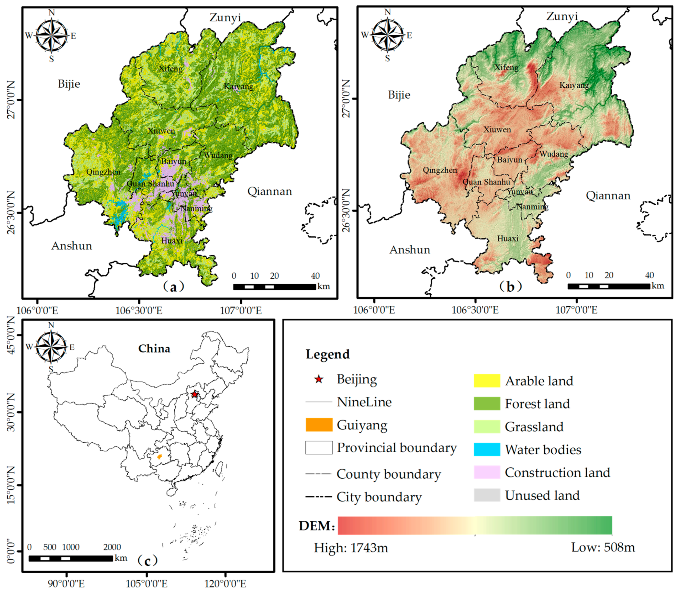
Figure 1. Location, administrative divisions, land use, and elevation of Guiyang city. (a) Land use in Guiyang city in 2020; (b) elevation of Guiyang city; (c) location of Guiyang city in China.
Land 11 01837 g001
Figure 2. The Framework of this study.
Land 11 01837 g002
Figure 3. Spatial zoning scheme of Guiyang city.
Land 11 01837 g003
Figure 4. Spatio-temporal patterns of habitat quality in Guiyang city from 2000 to 2020.
Land 11 01837 g004
Figure 5. The magnitude of change and flow direction of each grade of habitat quality in Guiyang city from 2000 to 2020.
Land 11 01837 g005
Figure 6. Spatio-temporal patterns of habitat degradation in Guiyang city from 2000 to 2020.
Land 11 01837 g006
Figure 7. Spatio-temporal patterns of human footprint in Guiyang city from 2000 to 2020.
Land 11 01837 g007
Figure 8. The magnitude of change and flow direction of each grade of human footprint in Guiyang city from 2000 to 2020.
Land 11 01837 g008
Figure 9. Spatio-temporal relationships between habitat quality and human footprint in Guiyang city from 2000 to 2020.
Land 11 01837 g009
Figure 10. Spatial zoning results of Guiyang city.
Land 11 01837 g010
Figure 11. The proportion of different zones in the whole region and each county (district or city).
Land 11 01837 g011
Table 1. Data sources and descriptions in this study.
Data NameResolutionPeriodData Source
Land use dataVector2000, 2010, 2020http://www.resdc.cn/, accessed on 3 March 2022
DEM dataRaster, 30 m2015http://www.gscloud.cn/, accessed on 3 March 2022
Population density dataRaster, 1 km2000, 2010, 2020http://www.resdc.cn/, accessed on 8 March 2022
Road dataVector2000, 2010, 2020http://www.resdc.cn/, accessed on 8 March 2022
Night time light dataRaster, 1 km2000, 2010, 2020https://eogdata.mines.edu/products/vnl/, accessed on 3 April 2022
Table 2. Threat factors and their maximum distance of influence, weight, and type of decay over space.
ThreatsMax Distance of Influence (km)WeightDecay Type
Paddy field1.00.5Linear
Arid land2.00.7Linear
Urban land6.01.0Exponential
Rural settlements3.00.8Exponential
Other construction land4.00.7Exponential
Unused land1.00.5Linear
Table 3. Habitat suitability degree and sensitivity to threats of land use type.
Land Use TypeHabitat SuitabilityPaddy FieldArid
Land
Urban LandRural
Settlements
Other
Construction Land
Unused Land
Paddy field0.40.00.20.50.30.20.0
Arid land0.20.20.00.50.20.20.1
Woodland1.00.80.81.00.80.60.4
Shrub wood0.80.40.40.60.40.20.2
Sparse forest0.60.80.81.00.80.20.4
Other woodland0.60.60.60.90.80.50.4
High-coverage grassland0.80.70.70.90.80.60.3
Moderate-coverage grassland0.70.40.40.60.50.30.2
Low-coverage grassland0.60.30.30.60.40.40.2
Graff0.90.70.70.80.60.40.2
Lake0.80.70.70.80.60.40.2
Reservoir0.80.70.70.90.70.50.4
Urban land 0.00.00.00.00.00.00.0
Rural settlements0.00.00.00.00.00.00.0
Other construction land0.00.000.00.00.00.0
Unused land0.10.10.10.40.30.30.0
Publisher’s Note: MDPI stays neutral with regard to jurisdictional claims in published maps and institutional affiliations.