Abstract
Erosion and pollution in the Citarum River have reached a very worrying stage. To overcome this problem, the government has launched the Citarum Harum program. One of the policies synergistic with the Citarum Harum program is the application of soil and water conservation principles in farming seasonal crops in the upper Citarum watershed (UCW). Historically, policies and programs for developing pro-conservation farming in this area have been carried out for at least three decades but have not been effective. Increasing the effectiveness of policies requires the existence of suitable instruments. Therefore, it is necessary to have a comprehensive and in-depth understanding of the attitudes and behavior of farmers in applying soil and water conservation. This study aims to identify the factors influencing farmers’ probabilities and participation in applying soil and water conservation techniques. A double-hurdle approach is used to identify determinants of farmers’ participation and intensity in applying conservation practices. The data were collected from samples of 244 farm households’ growing seasonal crops out of 499 farm households sample in the Bandung and West Bandung Districts. The results show that the determinants of farmer participation and intensity in the application of conservation lie in the ability to finance, land tenure and utilization, and the physical condition of the land. The level of education only affects participation opportunities, even if the increment is significant. In the future, conservation priorities must be more directed at a vegetative approach through developing synergistic perennial crops with particular efforts to convert vegetables on the sloping lands to perennial crops.
1. Introduction
1.1. Background
Land and water conservation is one of the critical factors in achieving high and sustainable agricultural productivity. Many soil conservation techniques (SCTs) have been widely used worldwide to alter soil and water processes [1]. In the broader context, SCTs perform multiple functions that improve environmental quality, including the provision of the following ecological services: (1) reducing runoff and conserving soil [2], (2) filtering water [3], (3) improving soil fertility and land productivity [4], (4) increasing crop yield and ensuring food security [5], (5) enhancing biodiversity [6], and (6) creating esthetic landscapes [7].
Although the goals of each conservation technique tend to be unique, some conservation techniques have multiple benefits. For example, terraces conservation technique situated on sloping land to prevent or minimize erosion. At the farm level, the benefit is conserving top soil to maintain soil fertility. Moreover, terraces are also appropriate for regulating the water supply for the plants in the field. In a broader context, the benefit is a reduction in the rate of siltation of the river or related reservoir.
From an empirical point of view, erosion due to water flow is the most widespread form of soil degradation worldwide [8] and is considered one of the major threats to soil ecosystem services [5,9]. Empirically, it is challenging to prevent soil erosion entirely, but it can be reduced to a maximum acceptable level of soil loss tolerance [10].
One of the essential ecosystem services provided by SCTs, water erosion control, has been well-studied, and recent research has focused on the efficiencies of some SCTs, such as terraces [7,11], mulching [12,13], afforestation [14], and soil management techniques [15,16].
In Indonesia, one of the most debated soil degradation issues is one that is found in the Citarum watershed. This region is one of the strategic watersheds in the West Java Province, covers an area of 682.23 thousand hectares across ten districts and two cities, and is a water source for power plants, agricultural irrigation, inland water fishery, and raw water. There are three large reservoirs in the Citarum watershed to meet the needs of the power plant, namely the Saguling Reservoir with a volume of 982 million m3, the Cirata Reservoir with a water volume of 2165 million m3, and the Jatiluhur Reservoir with a water volume of 3000 million m3, which generates 1400 MW of electrical power.
In line with population growth, the pressure on the Citarum watershed is getting bigger. In the upstream, the issues include: (i) soil erosion and (ii) the expansion of critical land, especially in the state forest areas, plantation lands, and community lands. In the central Citarum watershed, inundation often occurs, while in the downstream, the problems are, among others, a narrowing of the river body due to sedimentation and accumulation of industrial and domestic waste. All those conditions cause critical problems for land in the Citarum watershed area of 199.51 thousand ha. Out of this total area, 77.04 thousand ha are located in the UCW, which consists of 20% forest and 80% outer forest areas. Based on administrative boundaries, around 56% of the critical land in the UCW is located in the Bandung Regency and the remaining 34% is located in the West Bandung Regency.
Based on various issues and problems in the Citarum watershed, the government has issued a series of programs and policies to rehabilitate the watershed. The phenomenal program is the Citarum Harum Program mandated by Presidential Regulation Number 15/2018 regarding the Citarum watershed rehabilitation program. It is a national program to control the damage and pollution and restore the watershed. Based on the empirical evidence, one of the urgent programs in this area is tackling land degradation due to erosion.
Farmland in the UCW is predominantly located at high altitudes with light (15–30%) to steep slopes (>30%). Steep slopes imply a high topsoil erosion rate and soil fertility degradation. Government programs have promoted various soil and water conservation techniques, some of which farmers have widely applied, and others have been used to a limited extent. However, not all farmers participate in the conservation program. Furthermore, some participant farmers only practice partial conservation and do not sustain [17].
Most farmers in the UCW grow seasonal crops, in particular, rice and vegetables. Rice is planted in the irrigated lowland, whereas vegetables are planted in the dry land or in the irrigated lowland, during the dry season. In the steep topography, all plots of the irrigated lowland were terraced since some years ago. In the case of the vegetable farm, even though the land is steep, almost all plots are not terraced. The conservation practices are usually intended to avoid water lodging in the vegetable plots. Therefore, the main sources of soil erosion are from vegetable farms.
Agricultural conservation policy and programs will be effective if the majority of targeted farmers are actively participating in the implementation of the program. The willingness of farmers to implement conservation practices is influenced by many factors, consisting of technical and socioeconomic aspects. Therefore, we need to analyze farmers’ behavior toward soil and water conservation practices and the determinant factors. This is the primary motivation to conduct this research.
1.2. Research Objectives
This study aimed to describe conservation practices of the seasonal crop farming in the UCW and analyze determinants of farmers’ behaviors in conservation technology adoption. Based on empirical observation, this study is focused on the owner-operator farmers’ cultivation of seasonal crops in practicing conservation, which oriented directly or indirectly toward reducing soil erosion.
2. Material and Methods
2.1. Theoretical Framework
As in the case of Indonesian farmers in general, the majority of farmers in the UCW are small farmers with land holdings of less than 0.5 ha. They consist of farmers who own land and those who do not own land. Farmers who do not own land work on other farmers’ land with a profit-sharing system, rent, mortgage, and borrow.
Regarding agro-ecosystem conditions and agrarian density, the area of farm plots in the study area is generally small or narrow. The number of farm plots varies between 1–5 plots. Following regional conditions, farmers cultivate both seasonal and perennial crops on their land.
In practice, the farmer’s decision to apply one or a combination of several techniques depends on the objectives and constraints faced. The application of a conservation technique includes technical capabilities and the availability of resources controlled by the farmers concerned. Therefore, the aspects considered in decision-making and selecting soil and water conservation techniques include technical and socioeconomic factors.
In making decisions to implement conservation, farmers are faced with the conditions that: (i) the benefits of conservation are generally not “quick yield”, (ii) implementing conservation requires money and energy, and (iii) financially, conservation farming is not always more profitable, especially in the short term. Therefore, conservation techniques are generally applied to owned agricultural lands.
Referring to this phenomenon, the population of farmers in this study are farmers who cultivate seasonal crops on their owned land. Therefore, eight conservation techniques are considered in this study, which are directly or indirectly oriented to soil and water conservation, mainly erosion control: terrace, beds, ditch, drainage, mulch, grass, ponds, and cultivation of trees in the farmlands cultivated seasonal crops.
The farmer’s decision to conserve includes two stages. The first stage is the choice to perform or not perform conservation. For those who decide to perform conservation, the second stage is choosing what conservation techniques and their level of intensity.
Even though it has been of farmers’ routine activity, the decision-making process in farming including conservation practices is not an easy task. This is due to the fact that, empirically, a farmers’ objective is multi-objective in nature, with multi-dimensional constraints. In line with the progress on development, economic aspects often dominate a community’s value. However, similar to other communities’ member farmers, daily life is also governed by sociocultural norms. According to Khuc [17], core values in an individual’s or community’s decision-making framework include: (i) cost–benefit, (ii) use values, (environmental/social values), (iii) preference, (iv) trust, and (v) scarcity. The priority core values of the farmers are varied. The main input in the decision-making process is information. The decision-making mechanism, starting from entry of information until the final decision (accept/agree, delay, or reject/disagree) is not linear, but dynamic. Khuc [17] described that the process work mechanism of the sponge is to absorb or reject the input being information particles from the living environment to optimize utility. Therefore, the inventor of this theory called it the mindsponge theory, and its application in the field of economics is called mindspongeconomics.
Corner solution responses are frequently observed in the social sciences. The same thing happened in the behavior of farmers in applying soil and water conservation techniques. Some farmers perform conservation, while others do not. For those who do, the intensity also varies because the goals and needs and the resources they control vary.
One common approach to model phenomena that give rise to corner solution responses is to use the Tobit model. However, if the decision to participate is decoupled from the amount decision, such as in the double-hurdle model, then the Tobit model is inappropriate. The double-hurdle model is an appropriate alternative to the Tobit model [18,19,20]. The implementation of the model allows the errors of the participation decision and the amount of decision to be correlated.
Social interaction between intra-regional individuals is usually more intense than inter-regional, so the behavior of intra-regional individuals is relatively more homogeneous than inter-regional. Therefore, it is common to report standard errors that account for the clustering of units. Typically, the motivation for the clustering adjustments is that unobserved components in outcomes for units within clusters are correlated. However, because correlation may occur across more than one dimension, this motivation makes it difficult to justify why researchers use clustering in some dimensions, such as geographic, but not others, such as age cohorts or gender [21]. In that case, the maximum likelihood with clustered-robust standard errors is an appropriate method to estimate the parameters.
2.2. Analytical Methods
Double-hurdle models are used with dependent variables that take on the endpoints of an interval with positive probability and are continuously distributed over the interior of the interval. For example, suppose farmers make their conservation decisions in two steps. First, the participation decision: the farmer determines whether he or she wants to practice or not. Second, the quantity decision: the farmer determines an optimal activity amount given his or her circumstances. If yi represents the observed conservation activities amount of the individual, we can model it as:
Letting denote the cumulative distribution function (CDF) of a bivariate normal with correlation , the log-likelihood function for the double-hurdle model is
Note that the double-hurdle model can be reduced to the Tobit model by setting and taking the limit.
2.3. Empirical Model
From the examination of the data, it is known that the number of farmers who do not perform conservation is more than half (52%). For farmers who carry out conservation, the intensity (quantity) varies from 1 to 8. The definition of intensity is a combination of the type and number of conservation activities carried out. For example, suppose a farmer performs one type of conservation on two different plots, then the intensity of conservation he performs = 2. Another example is if there are three types of conservation (terrace, beds, ditch) in one plot, the intensity = 3. More than 80% of conservation farmers carry out conservation intensity between 1 – 3 conservation activities. So, let y = intensity of conservation carried out, then:
Types of conservation applied by farmers in the study area include (i) terracing, (ii) beds, (iii) ditch, (iv) drainage, (v) mulch, (vi) grass, (vii) reservoir (well), and (viii) trees. In this context, manure and compost are not included because almost all farmers used the organic fertilizers.
From a series of preliminary tests, the most suitable double-hurdle model, applied in this study, is as follows:
(a) Participation equation (practicing conservation techniques in farming):
(b) Quantity equation (intensity of practicing conservation activity):
where
where:
age = age of the farm household head (year)
educ = education of household head (year)
educ2 = education of household head measured in higher incremental (educ square)
DMJ = dummy variable of household head’s main job (0 = farmer, 1 = others)
r_lbf = share of household members aged 15–64 years concerning total household (%)
r_farm = share of household members working in farming concerning the household
members aged 15–64 years (%)
lown = the total size of owned farmland (hectare)
Llhold = area cultivated in one year, including perennial crops (hectare/year)
l_annual = area cultivated in one year, for seasonal crops only (hectare)
avg_plot = the average size of plot owned
plot_all = number of owned plots held
r_stplot = share of the moderate and steep plot (%)
s_f_inc = share of farmer household income from farming (%)
inc_cap = per capita income (IDR million)
Inv = proxy variable to measure farmers’ ability to invest
DIST = dummy d dummy variable of a district (0 = Bandung, 1 = West Bandung)
The estimation method applied is maximum likelihood with clustered-robust standard errors, because it is one of the most efficient and the parameter estimation results are consistent [22,23,24]. The cluster used is district. The software used in parameter estimation was Stata 15.1, created by StataCorp. company, Texas, USA, whose syntax imitates [19].
2.4. Study Site and Data Set
The data used in this paper are a sub-sample of the farm household survey data of the ACIAR-funded research project entitled “the Agricultural Policy Research to Support Natural Resource Management in Indonesia’s Upland Landscapes (Indogreen)”. The study was conducted using household survey techniques in 2 districts, 14 sub-districts, and 22 villages: 9 sub-districts with 14 villages in the Bandung District and five sub-districts with eight villages in the West Bandung District. Detailed research locations are presented in Appendix A. The survey location focused on the Citarum Watershed, especially in the upstream watershed areas (Figure 1).
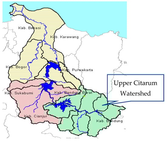
Figure 1.
Map of Citarum Watershed.
The Citarum watershed itself consists of 8 sub-watersheds; only 6 of them are agriculture areas (rural): (1) Seminyak, (2) Ciwidey, (3) Cisangkuy, (4) Cirasea (5), Citarik, and (6) Cihaur. The two urban sub-watersheds are then excluded from the study. In terms of local administrative area, most of these sub-watersheds (85.5%) are located in two districts: the Bandung District (56.2%) and the West Bandung District (29.3%). Therefore, the study area is focused on these six sub-watersheds within the two districts.
The sample population in “Indogreen’s” research is 499 farm households, namely households that manage to farm, both on their owned and non-owned land. Samples were randomly selected from the farm household population. In addition, the descriptive analysis includes all samples of farmer households and sub-samples that focus on this research, namely smallholder farmers who cultivate food and seasonal crops.
The sample size of smallholder farmers who plant seasonal crops is 244 HHs, consisting of 141 HHs in Bandung and 103 HHs in West Bandung. Out of 244 HHs, less than 50% implement conservation practices. The definition of “practicing” in this study includes the manufacturing or maintenance activities carried out by the farmer in the observation period, namely the last one year. The conservation practices considered in this study include eight types: terraces, beds, ditches, drainage, mulch, grass, reservoir/pond, and trees.
This study is focused on samples of owner-operator farmers (244 HH) who grow food crops and vegetables. The reasons are: (a) decision makers in conservation are farmers who own the land they are working on, because (i) conservation requires a lot of cost and labor, and (ii) the benefits of conservation tend to be long-term so that conservation is generally applied to land with tenure status and relatively permanent property, and (b) land cultivation on plots of seasonal crops is generally more intensive so that land and water quality degradation take place more quickly, and plots with steep slopes are prone to erosion.
3. Results
3.1. Overview of Land Tenure and Cropping Patterns in the Upper Citarum Watershed (UCW)
The landscape of UCW is primarily mountainous. Meanwhile, the population is very dense, and most of the people are farmers, although some do not source their income from farming. Under such conditions, the characteristics of land tenure and cropping patterns in this area are as follows. First, the agricultural land consists of small plots. Second, land tenure status varies, including owner-operator, shareholder, land tenants, and tenants with different profit-sharing methods. Third, an intensive cultivation system with various types of commodities.
Of the total farmed land plots, less than half (49%) of the land is owned. The average size of owned plots is about 0.36 hectares, while non-owned plots are 0.20 hectares. The distribution of plots according to land status shows that the majority (42.70 percent) of farm plots are owned land, other plots are borrowed (21.87 percent), rented from other farmers (18.60 percent), or part of profit-sharing (9.74 percent). In addition, there are plots of farmed land with pawn status in a small percentage.
The characteristics of the agricultural land tenure in the Bandung Regency differ from those in the West Bandung Regency. The size of the land plots in the West Bandung Regency (0.2 ha) are generally smaller than in the Bandung Regency (0.29 ha). Land transactions in the Bandung Regency are more prevalent than in the West Bandung Regency. For example, in Bandung, the percentage of privately owned land plots is only 37%, whereas in West Bandung, it is 52%. However, the portions of rental and profit-sharing plots in the Bandung Regency are 22% and 12%, whereas in the West Bandung Regency they are 12% and 7%, respectively.
The distribution of plots shows that most of the land plots are planted with horticultural commodities (42.4 percent), rice (31.4 percent), coffee intercropping (14.53 percent), and others. Most of the coffee (20.5 percent) is grown on plots belonging to the state company, Perum Perhutani. Coffee farming by farmers is consistent with the partnership program promoted by the government, namely the partnership program for planting trees (especially coffee) on Perum Perhutani land. The programs are the Community Forest Management Program (PHBM) and the Social Forestry Program. Through these programs, farmers may utilize Perhutani land with guaranteed access to land use for a certain number of years.
There are three planting seasons in one year: the rainy season, and the first and second dry season. Most farmers (97 percent) cultivate their land in the rainy and first dry seasons. About 43 percent of the total plots include rainfed rice fields, 35 percent are dry land, and 22 per cent are other types.
3.2. Owned Plots Farming
The dominant type of the owned plots land is dry land on steep, moderate, and flat slopes. The second-largest proportion is irrigated land (mostly planted with rice), followed by rainfed rice fields. Meanwhile, land with steep slopes has a tiny percentage of irrigated and rainfed rice land (Table 1).

Table 1.
Distribution of owned plots by type and slope.
Most of the land with very steep slopes (>30%) is planted with horticultural commodities, followed by estate crops, and only a small area is planted with rice (Table 2). Likewise, on a relatively steep slope, the most significant area is planted with horticultural crops, estate crops, and rice. Meanwhile, the most expansive flat land is planted with horticultural (vegetable) crops and rice, while only a small amount is planted with estate crops.
Table 2.
Total owned plots by slope and use (hectare).
Most of the farmers cultivate seasonal crops twice a year, namely in the rainy season and dry season 1. On some lands with sufficient water, some farmers cultivate three times per year (Table 3).
Table 3.
Number of Plot and Average Size of Owned Plots Planted with Seasonal Crops by Season.
The ten main types of seasonal commodities planted by farmers, sorted by the percentage distribution of the number of plots, are rice, chili, corn, tomatoes, potatoes, leeks, cabbage, sweet potatoes, shallots, and carrots. However, when viewed from the distribution based on planted area, rice still ranks first, followed by potatoes, chilies, corn, and cabbage. Other commodities are distributed in a small percentage area. If observed according to the typology of agricultural land, horticultural (vegetable) crops are dominant in dry, rainfed, and irrigated land types. Meanwhile, rice is prevalent on irrigated land, partly on rainfed rice fields, and a small portion on dry land.
3.3. Farmers’ Motives for Conservation
Farmers’ motives for practicing conservation were identified through their reasons for implementing conservation actions, as described in the following. First, the types of conservation, such as terracing, weeds, and trees, are widely chosen and applied because they function to prevent erosion. Terracing is a conservation technique widely applied to rice fields. Initial terrace construction requires high costs, but farmers only need maintenance costs in the subsequent stage. Weeds and trees are cover crops that retain water and soil nutrients and reduce the damage to raindrops and runoff as a source of organic fertilizers while helping agriculture adapt to climate change and other interests.
Second, the application of beds and mulch conservation by farmers aims at maintaining land, including maintaining and protecting the soil surface from erosion, maintaining soil moisture, preventing the loss of fertility elements provided through fertilization, preventing the development of pests and weeds, and suppressing evaporation. The application of this type of conservation is considered technically more accessible and affordable and directly impacts plant growth and farm production.
Third, the application of ditches and wells by farmers aims at managing water absorption so that water is available for plant maintenance, especially during dry times. According to farmers’ perceptions, this conservation practice is technically easy and accessible.
Fourth, the participation of farmers in implementing conservation with the beds system is the most widely applied agricultural conservation practice, especially in vegetable and horticulture farming. Out of the 137 participants, 77.4 percent said their use of beds was aimed at sustainably maintaining plants and land. This type of conservation is technically and economically perceived as easy and relatively inexpensive to implement.
Fifth, terracing is widely applied in the rice fields by 129 participants to prevent erosion. Most of the terraces were built a few years ago. As an illustration, for terracing of all the owned plots land with seasonal crops, about 52% were built before 2000 and about 34% were made before 1990. With such conditions, the main activity in the practice of terracing carried out at this time is only for maintenance and repair if needed.
3.4. Mastery of Conservation Techniques
Similar to the phenomenon that occurs in most rural areas in Java, the land size cultivated by most farmers in upper Citarum is less than 0.5 hectares. Therefore, farming cannot be relied on as the primary source of family income. To meet the needs of their families, most farmers seek additional income from agricultural labor and work outside the farm, either in rural or urban areas.
Although farming cannot be relied on as the primary source of income, family farming is generally maintained and passed on to their descendants. The tendency to pass down the family farming business is not only based on financial considerations. One of the factors often considered by farmers is maintaining their farmland because the land is a strategic resource. In addition, non-agricultural job opportunities in rural areas are still limited; meanwhile, job opportunities in urban areas are not always accessible to most of the workforce in the non-formal sectors.
In general, the young workforce in rural areas, including those in the UCW, are less interested in working as farmers. The indication is that when they can access other jobs, their involvement in family farming is “helping” their parents’ work. Related to that, the “aging” farmer is a common phenomenon in rural areas, including the UCW. Most of the conservation activities in the UCW are performed manually. Even in manufacturing terraces, almost all do not use mechanical equipment. Beds, dictation, and drainage are also built manually because the plots of land are generally small.
Similarly, to build ponds and wells, farmers do it manually. However, with the condition of small plots of land for planting grass and trees, there is no need for mechanical equipment. In such situations, the technology applied to conservation activities has been well-controlled by farmers. This observation confirms the farmers’ acknowledgment that more than 78 percent of the farmers said it was “easy” and about 20 percent said it was “very easy” to perform conservation (Appendix B).
In general, farmers’ applications of conservation techniques are influenced by various considerations classified into difficulty, convenience, and affordability. Easy or affordable is associated with considerations of technical aspects, and socioeconomic and other limiting factors. Based on the perception of conservation farmers, the practices of the eight types of conservation analyzed in this paper fall into the easy category. The proportion of perceptions of each type of conservation practice is above 60 percent. Terraces and wells are perceived as slightly more complicated (more than 30 percent) because, in the early stages, they require high energy, time, and costs. However, the general conservation farming practices in the UCW are still limited to implementing these conservation techniques. Even though land tenure is considered an essential factor in adopting conservation practices, farming practices with this status have not shown the expected evidence. This fact reinforces the results of research, which found that smallholder farming is more risk-reducing than profit-maximizing.
3.5. Participation and Intensity of Conservation Practices
Less than half (48%) of the seasonal crop farmers are performing conservation, but it differs across districts. For example, in the Bandung Regency, those who participated were comparable to those who did not participate, whereas in the West Bandung Regency, it was around 45% (Table 4).
Table 4.
Distribution of farmers by their participation in conservation (%).
The highest intensities in the participating farmer groups were one and two activities. In the Bandung Regency, the highest intensity was two activities, whereas in the West Bandung Regency, it was one activity. Considering the problems faced by the farmers, the main objectives of conservation are to minimize erosion and maintain water availability. The use of manure and compost, which theoretically can be seen as conservation of soil fertility, was not included as a conservation technique in this study. An interesting phenomenon is that farmers who do not participate in the conservation use of manure or compost are higher (81% vs. 70%). The high percentage of farmers using manure and compost in the group of farmers who do not carry out conservation is related to the primary commodity of their farming, namely vegetables. Their tendency not to perform and/or to be less concerned with conservation-oriented activities to prevent or minimize erosion is quite worrying, because more than half (52%) of the plots planted with vegetables have moderate and steep slopes.
In the participating farmer groups, the most common form of conservation is the civil approach, which includes the construction of terraces, beds, drainage channels, and ponds. However, the low interest in conservation based on the vegetation approach by planting trees is related to the tendency of farmers to condition their vegetable crops to get enough sunlight. Therefore, the percentage of farmers who carry out conservation in beds, mulch, and ponds in the Bandung Regency is higher than in the West Bandung Regency. However, the percentage of farmers who perform hatchery is higher in the West Bandung Regency. Therefore, it is almost equal to other types of conservation (Figure 2).
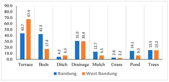
Figure 2.
Distribution of farmers by type of conservation practices.
These differences are related to differences in land use. In the Bandung Regency, the percentage of plots planted for horticulture is 51%, whereas in the West Bandung Regency it is 37%.
3.6. Determinants of Participation
The determinants of farmers’ behavior in conservation include two dimensions: (i) factors that affect the probability of farmers for conservation (participation equation) and (ii) factors that affect the intensity of participation (quantity equation). The parameter estimation results using the double-hurdle model, as presented in Table 5, show that the determinants of participation and the intensity of the application of conservation lie in several aspects related to (i) control and utilization of farmland, (ii) farming land conditions, (iii) contribution of farming to household income, (iv) farmer’s ability to finance conservation with indicators that include income per capita and proxy variable of farmer household’s potential in investing, and (v) regional characteristics (locality aspect).
Table 5.
Double hurdle parameter estimates of factors affecting farmers on conservation practices.
Regarding household characteristics, the only influencing factors are the level of education and the share of household members who work in agriculture, which are conditional. Farmer’s age, farmer’s primary occupation, and share of the family workforce do not affect the probability and intensity of participation. Other studies concluded that the effect of age on decisions to practice conservation can be positive or negative.
According to the age group, the composition of farmers who perform conservation is not much different from those who participate. If the age of the farmer is divided into five categories: (a) ≤35, (b) 36–45, (c) 46–55, (d) 56–65, and (e) over 65 years; in the group of farmers who do not perform conservation, the proportions are 12, 19, 24, 29, and 16 percent, respectively. In the same order, the proportions for farmers who perform conservation are 6, 26, 27, 25, and 16 percent. The average number of working-age household members in the farmer group who participate in conservation is 2.48, whereas for those who do not participate it is 2.59 (t = −0.863). In the same order, the ratio of working-age household members to the number of household members is 0.73 to 0.74 (t = −0.594).
In the participating farmer groups, the average number of working-age household members in the participation intensity sub-groups 1, 2, 3, 4, and 5 are 2.46, 2.50, 2.71, 2.63, and 2.00, respectively. This sub-group is the majority of farmers (91%) who perform conservation.
The level of education only affects the context of the probability of participating, even if the incremental is large enough. The explanation of this phenomenon requires further study. A provisional hypothesis is that the incremental level of education is positively correlated with the understanding of conservation benefits and has implications for the motives for participation. Most (49%) of the farmers in this area graduated from elementary school. The number who did not graduate from elementary school was around 23%, while those who graduated Junior High School and High School were 18% and 8%, respectively. The higher the level of education, the greater the probability/opportunity to participate in conservation. Theoretically, the level of education correlates positively with literacy (in a broad sense). In this regard, the higher the level of education, the more comprehensive the knowledge and the better the understanding of conservation benefits. In this study, the level of farmers’ education affects the opportunities for farmers to carry out conservation.
The share of household members who work in farming is the number of household members who work in farming divided by the number of working-age household members. In the group of farmers who carry out conservation, this variable positively affects the number of conservation activities carried out. If the number of farmers participating in conservation is divided into two categories, namely: (i) with an intensity of one and two and (ii) with an intensity of more than two, the proportions (i) and (ii) are 66 and 34 percent, respectively. The average share of household members working in farming for categories (i) and (ii) are 36.56 and 5.67, respectively (t = −2.8021).
3.6.1. Land Tenure and Land Use
In this study, the land tenure aspect used to determine the effect on farmers’ probability for conservation and the intensity of conservation includes the following three variables, namely: (i) area of land ownership, (ii) total arable area in a year, including arable land for perennial crops, and (iii) the total area of cultivation per year specifically for seasonal crops.
In the context of the probability of participating, the larger the land owned or cultivated, the greater the probability of participating. With more land, farmers have flexibility in trying to implement conservation activities and face the risks that may. This risk can be in the form of reduced land area for constructing terraces, ditches, and other conservation buildings, which will affect the results in the short term.
The average land area owned by non-participating farmers is 0.32, while that of participating farmers is 0.47 (t = −2015). In the same order, the average cultivated areas (total including plots of land planted with perennial crops) are 0.76 and 0.97 hectares, respectively. This phenomenon indicates that the application of conservation is more likely to be concentrated on farmers with larger land sizes. The problem is that the number of farmers with large land tenure in this research site is relatively small because the distribution is unequal. As an illustration, the Gini index of land ownership in this population is 0.56, where the cumulative area of land owned by the top 10% of farmers is around 43%. In arable land control, the Gini index is 0.53, where the cumulative area controlled by 10% of farmers is about 40%.
The data above on farm size showed that the larger the ownership or control of arable land for participating farmers, the fewer the number of conservation activities. The cause is related to two factors: the availability of labor and the desire to maintain the area of arable land. First, concerning labor availability, the larger the area of land controlled, the more work and labor are needed, so farmers need to focus more on certain conservation activities and/or on land plots that need to be prioritized. Second, it is related to efforts to maintain the area of land that can be used for farming, because the average size of land tenure is small.
In contrast to total land tenure, the effect of the area of arable land planted with seasonal crops tends to be the opposite. The impact of cultivated area for seasonal crops on the probability of participating in conservation is negative, but for farmers who perform conservation, the effect on conservation intensity is positive. This observation is related to devoted labor, as, empirically, seasonal crop farming is labor-intensive. Regarding the availability of the existing family labors, the larger the farming of seasonal crops, the less labor that can be devoted to carrying out conservation activities. However, for farmers who have decided to perform conservation, the larger the size of seasonal crop farming, the more conservation activities they have to perform, particularly for the maintenance of beds and ditches.
3.6.2. Conditions of Farmland
There are three variables used to determine the effect of land conditions on farmer behavior in conservation, namely: (i) the average area of farm plots, (ii) the number of land plots controlled, and (iii) the share of land plots with moderate and steep slopes to the total number of plots. The only variable used to determine its effect on participation and intensity is variable (ii). Variable (i) is only relevant to its impact on the probability of participating in conservation, whereas variable (iii) is only relevant to its effect on participating farmer groups. The average plot size has a significant effect on the probability of conservation. The larger it is, the lower the chance to apply conservation. The number of plots negatively affects the probability of conservation and the intensity of participation in the participating farmer groups. The more plots of agricultural land they control, the less likely farmers will participate. However, for the farmers who participate, the more plots they control, the more conservation activities they carry out.
For the same number of plots, the greater the proportion of sloping plots, the more conservation activities must be carried out. The parameter estimation results confirm that the effect of the proportion of plots with moderate and steep slopes on the conservation intensity is positive. The more land plots with moderate and steep slopes, the higher the intensity of conservation activities to be carried out. In this analysis, the proportion of plots that have moderate and steep slopes for farmers who carry out conservation is 0.67, with a minimum of 0.43 and a maximum of 1, whereas for farmers who do not practice conservation, the proportion of plots with moderate and steep slopes is lower than 0.54, with a minimum of 0 and maximum of 1. The reason is that relatively flat farmland makes farmers less motivated to carry out conservation activities.
3.6.3. Contribution of Farming to Household Income
The role of farming in the household economy of farmers determines many aspects related to farmer decisions regarding farm management. The same applies to farmers’ decisions to undertake soil and water conservation. Thus, household income is one of the main determinants of farmer participation in conservation. The parameter estimation results show that the greater the share of the farmer’s income obtained from farming, the greater the probability for conservation. This result implies that one way to encourage farmers to perform conservation is by creating incentives conducive to increasing farm income. For this purpose, a feasible step is to increase the added value of production; for example, by increasing the quality of their products to increase selling prices, using high-yielding varieties, and using a more precise application of fertilizers to reduce production costs.
3.6.4. Farm Income and Investment Capacity
The parameter estimation results show that the higher the income per capita, the higher the conservation intensity carried out by farmers. There is an indication of a positive impact of the proxy variable on the ability to invest, meaning that its effect on the probabilities for farmers to participate in conservation is positive.
The contribution of farming to household income, per capita income, and the ability to invest determine farmer behavior in conservation. The problem is that the practice of conservation requires a large amount of money and energy. Various ways to increase income, both in farming and non-farming activities, also need costs and additional work time. Meanwhile, the benefits of conservation can not necessarily be directly seen or enjoyed in the short term. In this regard, breakthrough policies and programs are needed to solve these trade-offs.
3.6.5. Regional Characteristics (Locality Aspect)
The incorporation of regional dummy variables (Bandung and West Bandung) in the double-hurdle model in this study has a dual function. First, treating districts as clusters in the clustered-robust estimator method is effective, as seen from its significant effect. Second, the parameter estimation results show that the participation of the farming community in the research site of the West Bandung Regency is lower than that in the Bandung Regency. However, the number of conservation activities carried out by the farming community in the West Bandung Regency is greater than that of the Bandung Regency.
4. Discussion
There are two types of measures for soil and water conservation, namely, mechanical/engineering/structural measures and biological measures. Mechanical measures are permanent and semi-permanent structures that involve terracing, bunching, trenching, check dams, gabion structures, loose/stone boulders, crib wall, etc., whereas biological measures are vegetative measures, which involve forestry, agroforestry, horticulture, and agricultural/agronomic practices [25]. Agronomic measures reduce the impact of raindrops through the covering of soil surface and increasing infiltration rate and water absorption capacity of the soil which results in reduced runoff and soil loss through erosion [26]. These measures are sometimes cheaper, sustainable, and may be more effective than structural measures [27]. In this research, we used conservation in term of mechanical measures rather than vegetative measures.
The uplands region, such as the Citarum upland, shows great potential to produce vegetable, agroecological compatibility, enhanced accessibility, developments in technology, and extensive infrastructure development [28]. This vegetable-based farming provides high remunerative returns, improves food security, and improves the welfare of the marginalized upland households. The opportunities of this vegetable-based farming, however, imply consequences on land erosion and land degradation [29,30].
The problem of land degradation due to soil erosion and nutrient depletion of agricultural land is generally a severe environmental problem in the highland’s agricultural areas [31]. Soil erosion is one of the key environmental issues of the highland ecosystem, and one of the major natural risk factors for developing high-value crops [32,33]. This condition is in accordance with the problem in the research location, namely in the upper watershed of Citarum, Indonesia. Vegetation changes and landscape conditions on a large scale also have an important effect on land degradation problems and this is a major concern for how to prevent land degradation [34]. Preventing land degradation is a cross-disciplinary problem, involving community development, land use, poverty alleviation, and biodiversity conservation. Innovative land and water conservation practices through such activities as agroforestry are needed to prevent land degradation for sustainable land use purposes [35,36,37]. Various programs are directed to involve the community to implement conservation so that agricultural and environmental sustainability can be achieved. Therefore, selecting and applying conservation types as the primary tool to help farmers manage and protect the soil, water, air, and natural resources on their farms is a strategic decision because it will determine the success and sustainability of the farming [38].
The principal objectives of conservation are protecting, preserving, the sustainable use of natural resources, and harmonizing the integration between social, economic, and ecological aspects [39,40]. Awareness of the importance of conservation practices and the need for preserving natural resources are the main factors determining conservation’s benefits. Considerations in planning and implementing agricultural conservation types include farmers’ technical ability to build conservation structures, the availability of supporting facilities, the socioeconomic conditions of farmers, and the personal ties of farmers to land, agriculture, and the environment. Regarding agricultural land in the UCW, the Citarum Harum Program should prioritize implementing conservation farming to avoid or at least minimize the incidence of landslides, erosion, and flooding [41].
Agricultural land is a strategic resource. The control of farming land, both the area of ownership and the area of cultivation, implies broad implications for the socioeconomic status of the farmer’s household as well as for support applied by farm technology. Land tenure status is also related to farmers’ opportunities to participate in conservation practices. Land conservation by farmers in the UCW is mostly private land conservation, in the form of building terraces, ditches, beds, and others. The results of this study indicate that the wider the land ownership or arable land, the greater the opportunity for conservation participation. However, using a sociopsychological approach, there was not any relationship between land ownership and farmer decision to participate in conservation programs sponsored by the government [42]. It could be that farmers’ participation in conservation tends to be related to the political aspects of the development process. Some conservation organizations are committed to conservation and sustainable agriculture, but other conservation organizations may forgo agriculture altogether [43,44]. The factor that motivates farmers’ adoption of soil and water conservation practices is the information dissemination approach [45].
The slope of the farm land is one of the determinants of farmers’ adoption of soil and water conservation practices and the decision to implement these practices continuously [39]. Cultivated land on a steep slope will be prone to erosion, primarily if soil and water conservation practices are not implemented [46]. Survey data show that the farmland owned by farmers is dominated by land with a slightly steep slope (slope 15–30%). The slope of land is also as one of the determinants of conservation participation. This observation is a logical consequence of efforts to avoid risk due to the steepness of the land, which may lead to crop failure due to waterlogging and landslides. In the case of farmers in Java, Indonesia who work on the steep parts of the highlands, they generally try to conserve land with varying conservation intensities [47]. However, there are also farmers who, even though they know the risks and negative impacts of farming on steep slopes, ironically, do not carry out conservation efforts [48].
The choice of commodity type is one of the most important decisions. In this context, the availability of rainwater is crucial for plant growth because most of the agricultural land is dry land and rainfed rice fields, especially for rice [49,50,51,52].
Managing agroforestry with woodlot for sustainable production has also been suggested as an alternative for sustainable land use practice in upland area. Result of agroforestry study in Ghana showed that woodlot producers with contractual relationships with the Forest Commission produced the highest benefit–cost ratio and net present value. However, this profitability is marginally higher than that of agriculture, which provides a fixed annual return. As a result, the cultivation of woodlots might not be a permanent solution to reducing agriculture contribution to the agroforestry program in Ghana [53]. Addressing these conflicting economic and environmental objectives has become increasingly topical [54].
In agroforestry, considering the prospect of income earned by farmers and its contribution to land conservation, the popularity of coffee as a mainstay commodity in agroforestry occurs in this research location and several other PHBM locations. Based on several studies, coffee-based agroforestry systems are also widely practiced in Latin America [55,56] and in Eastern Africa, for example, in Kenya [57], Ethiopia [58], and Uganda [59].
Some problems in promoting erosion reduction through the conversion of vegetable crops toward coffee farms on the farmers’ land in the upland Citarum watershed are: (i) very small farm size, and, as a consequence, (ii) low average household income. Furthermore, farmers are often forced to choose more short-term needs. The choice of commodity by farmers in this region is seasonal crops, in particular, vegetables, which are quick-yield. This is confirmed by the farmers’ statements, as follows. Around 66% of sample farmers mentioned “agree” and around 16% “strongly agree” that vegetable crops will significantly improve their household income. Based on the statement “I prefer to cultivate seasonal crops, such as vegetable and rice, compare to tree crops”, around 56% farmers chose “agree” and 12% chose “strongly agree”. However, based on the statement “Coffee is an important cash crop for my family”, around 53% of farmers mentioned “agree” and around 14% mentioned “strongly agree”. One of the feasible strategies to promote conversion of vegetable crops toward perennial crops is a policy and program to increase productivity and quality as well as the value added by coffee processing.
Wood/perennial and expansion of seasonal cultivated land were the key factors responsible for the changes in land use and cropping systems [60]. In this research, the land use in each plot consisted of several cropping systems, namely: (1) coffee with complex intercropping, (2) coffee with simple intercropping, (3) horticulture (vegetables), (4) fruits, (5) rice, (6) bushes, (7) forest, and (8) perennials/wood and others. For coffee, land use with complex intercropping is mainly found in plots with steep slopes with a percentage of 3.75% and an average plot area of 0.39 ha and steep slopes (1.2%) with an average plot area of 0.53 ha. Similarly, land use for simple intercropping has the same pattern as coffee with complex intercropping. Coffee cultivation by the community has been adopted by farmers in West Java through a long process of learning by doing [61]. Several factors that influence coffee cultivation by farmers, especially in forest areas using Community Forest Management (PHBM), are the experiences of coffee cultivation in the past. Coffee is suitable for growing in the study area, providing economic benefits, and mixed with seasonal crops, including vegetables. Before producing coffee, farmers and rural communities could still have seasonal agricultural products such as vegetables. The other most prominent land uses are horticulture, rice, and hardwood.
The choice of conservation technique is regarded as the most appropriate Better Management Practice (BMP) by farmers. It is decided based on the knowledge and considerations of the farmer’s socioeconomic environment from the accumulated learning and experience of managing the farm. It is also influenced by the intervention from outside parties in the form of conservation programs, by the government, private organisations, and NGOs. The reasons for choosing the type of conservation by farmers can be divided into four main groups: the reasons for preventing erosion, maintaining the availability of water for farming, maintaining land and plants, and other essential reasons. Each farmer can apply one or more types of conservation, either on the same land or on different plots of land. Researchers argue that smallholders who own land are more interested in implementing conservation than farmers with other types of land tenure. The results showed that the application of conservation farming in the upstream area of the Citarum watershed was not satisfactory. The various conservation programs in this area have not changed the behavior of farmers in prioritizing these crucial activities. Farmer behavior on this aspect is typical in most developing countries, so the environmental degradation of soil and water resources continues to occur [62].
In terms of the type of conservation, this research found that mechanical conservation bed and terrace are dominant. The bed conservation system is technically and economically perceived as easy and relatively inexpensive to implement. Still, its function benefits planting, maintaining, and harvesting. The terracing system is a conservation practice that, once established, allows the farmers to receive the benefit for an extended period to prevent rain runoff on sloping land, which can cause severe erosion [63]. The terraces are built on ridges, and channels are built across the slopes. Similarly, upland farmers in several countries, such as Ethiopia and Indiana, who have long recognized the importance of soil erosion control, have taken advantage of the application of terracing in conservation actions. The primary motivation behind conservation efforts is to maintain soil resources in a productive condition, reduce the risk of land use, and efforts to eliminate pollution of rivers and lakes or reservoirs because they prevent soil scouring by water [39,62].
Meanwhile, conservation with biological measures in this study shows a much lower participation rate, even though the application of this type of conservation is considered technically more accessible and affordable and directly impacts plant growth and farm production. Cover crops and mulch effectively reduce erosion and surface runoff on the ground to reduce transported topsoil [64]. The condition of the slope of the land will also affect the type of soil and water conservation practices. Farmers generally do not apply the terracing technique in areas with gentle slopes. Land conservation techniques using mulch are mainly carried out by farmers in the lowlands, while land management according to contours is the most widely applied conservation technique by highland farmers.
This study also confirms that socioeconomic considerations and the continuation of farming activities are significant determinants in farmers’ decision-making [65,66]. The urgency of economic needs through intensively developed farming activities motivates farmers to make decisions based on short-term considerations. Consequently, perceptions about the ease of conservation practice are not strongly related or are not followed by participation. This fact is similar to that found in Zimbabwe, as farmers with high knowledge about social, environmental, and economic benefits are indifferent to conservation farming practices. Furthermore, the land use intensity in steep areas makes the application of agricultural conservation not a priority [67,68].
Designing breakthrough policies and programs requires interaction, advocacy, and focus group discussions (FGDs) involving the central and local governments with all relevant stakeholders. There needs to be a comprehensive understanding that: (1) the benefits and multiplier effects of conservation are even more significant if carried out collectively, synergistically, and systematically; (2) the benefits of conservation, both direct and indirect, are not limited to the perpetrators but also the wider community; and (3) conservation is one of the actions that converge with the principles and objectives of sustainable development, and therefore the benefits are inter-generational.
5. Conclusions
The determinants of participation and intensity of conservation application lie in several aspects related to: (i) control and utilization of farmland, (ii) condition of farmland, (iii) contribution of farming to household income, (iv) farmer’s ability to finance conservation, and (v) regional characteristics (locality aspects).
Most farmers in the UCW comprehend soil and water conservation techniques. Therefore, breakthrough policies and programs that are considered effective in increasing farmer participation in the application of soil and water conservation in this area need to focus on facilitating, creating, and providing economic incentives. The policy instrument can be a “green box” subsidy for conservation coupled with an increased understanding of the benefits of conservation in a broader context.
Conservation techniques that need to be accelerated in their application are vegetation-based conservation techniques, by planting more perennial crops that provide high benefits to farmers and preserve natural resources and the environment. One way to do this is by expanding coffee and fruit farming. Facilitation efforts to increase the productivity and added value of the coffee are imperative to make farmers in the UCW willing to voluntarily change the land use from vegetables and other seasonal crops to coffee farms. The policy instrument used as an entry point to expand farmer participation in conservation is creating financial incentives. Several strategies can be pursued, for example, through the “green box” category of subsidies, for instance, the establishment of public infrastructure and the environment payment mechanism.
Author Contributions
Conceptualization: S., S.H.S. and E.; Investigation: S., S.H.S., F.N., H.T., E., T.S. and H.W.P.; Methodology: S. and E.; Writing—original draft: S., S.H.S., F.N., H.T., T.S. and H.W.P.; Writing—review & editing: S., S.H.S., F.N., H.T., E. and T.S. All authors have shared roles according to their respective disciplines and experiences as major contributors who equally discussed the conceptual ideas and the outline, provided critical feedback on each section, and helped shape and write the manuscript. All authors have read and agreed to the published version of the manuscript.
Funding
This research was funded by the Australian Center for International Agricultural Research (ACIAR) under project number ADP/2015/043 titled “Agricultural Policy Research to Support Natural Resource Management in Indonesia Upland Landscapes”.
Institutional Review Board Statement
No applicable.
Informed Consent Statement
Informed consent was obtained from all subjects involved in the study.
Data Availability Statement
No applicable.
Acknowledgments
This paper was written as part of a collaborative research project entitled “Agricultural Policy Research to Support Natural Resource Management in Indonesia Upland Landscapes.” The authors wish to thank the Indonesian Agency for Agricultural Research and Development (IAARD) and the Indonesian Center for Agricultural Socioeconomics and Policy Studies (ICASEPS) of the Ministry of Agriculture, Research & Development Centre for Socioeconomics, Policy & Climate Change Ministry of Environment and Forestry, International Center of Agro-Forestry (ICRAF), University of Adelaide, University of New England, and, in particular, ACIAR, for funding this collaborative research.
Conflicts of Interest
The authors declare no conflict of interest.
Appendix A
Table A1.
Location of the study.
Table A1.
Location of the study.
| District | Sub District | Village |
|---|---|---|
| West Bandung | Cililin | Mukapayung |
| Nanggerang | ||
| Cipongkor | Citalem | |
| Sarinangen | ||
| Cisarua | Pasirhalang | |
| Gununghalu | Sirnajaya | |
| Wargasaluyu | ||
| Sindangkerta | Mekarwangi | |
| Bandung | Arjasari | Baros |
| Mekarjaya | ||
| Cicalengka | Dampit | |
| Tanjung Wangi | ||
| Cikancung | Mandalasari | |
| Mekarlaksana | ||
| Ciwidey | Lebakmuncang | |
| Ibun | Dukuh | |
| Neglasari | ||
| Kertasari | Cihawuk | |
| Cikembang | ||
| Pacet | Cikitu | |
| Pangalengan | Pulosari | |
| Soreang | Sukanegara |
Appendix B
Table A2.
Farmers’ perceptions related to the difficulties of each conservation technique.
Table A2.
Farmers’ perceptions related to the difficulties of each conservation technique.
| Conservation Practices | Sample (n) | Respond (% Sample) | |||
|---|---|---|---|---|---|
| Very Easy | Easy | Difficult | Very Difficult | ||
| Terrace | 129 | 0.78 | 60.47 | 37.98 | 0.78 |
| Beds | 137 | 0.00 | 75.18 | 24.09 | 0.73 |
| Ditch | 64 | 1.56 | 79.69 | 18.75 | 0.00 |
| Drainage | 94 | 0.00 | 84.04 | 15.96 | 0.00 |
| Mulch | 51 | 0.00 | 72.55 | 27.45 | 0.00 |
| Weed | 28 | 3.57 | 96.43 | 0.00 | 0.00 |
| Pond | 74 | 1.35 | 85.14 | 13.51 | 0.00 |
| Trees | 75 | 1.33 | 94.67 | 4.00 | 0.00 |
| All | 244 | 0.77 | 78.07 | 20.86 | 0.31 |
References
- Arnáez, J.; Lana-Renault, N.; Lasanta, T.; Ruiz-Flaño, P.; Castroviejo, J. Effects of Farming Terraces on Hydrological and Geomorphological Processes. A Review. Catena 2015, 128, 122–134. [Google Scholar] [CrossRef]
- Wang, J.; Peng, J.; Zhao, M.; Liu, Y.; Chen, Y. Significant Trade-off for the Impact of Grain-for-Green Programme on Ecosystem Services in North-Western Yunnan, China. Sci. Total Environ. 2017, 574, 57–64. [Google Scholar] [CrossRef]
- Layman, C.A.; Jud, Z.R.; Archer, S.K.; Riera, D. Provision of Ecosystem Services by Human-Made Structures in a Highly Impacted Estuary. Environ. Res. Lett. 2014, 9, 044009. [Google Scholar] [CrossRef]
- Kagabo, D.M.; Stroosnijder, L.; Visser, S.M.; Moore, D. Soil Erosion, Soil Fertility and Crop Yield on Slow-Forming Terraces in the Highlands of Buberuka, Rwanda. Soil Tillage Res. 2013, 128, 23–29. [Google Scholar] [CrossRef]
- Borrelli, P.; Robinson, D.A.; Fleischer, L.R.; Lugato, E.; Ballabio, C.; Alewell, C.; Meusburger, K.; Modugno, S.; Schütt, B.; Ferro, V. An Assessment of the Global Impact of 21st Century Land Use Change on Soil Erosion. Nat. Commun. 2017, 8, 1–13. [Google Scholar] [CrossRef] [PubMed]
- Buscardo, E.; Smith, G.F.; Kelly, D.L.; Freitas, H.; Iremonger, S.; Mitchell, F.J.; O’Donoghue, S.; McKee, A.-M. The Early Effects of Afforestation on Biodiversity of Grasslands in Ireland. In Plantation Forests and Biodiversity: Oxymoron or Opportunity? Springer: Berlin/Heidelberg, Germany, 2008; pp. 133–148. [Google Scholar]
- Wei, W.; Chen, D.; Wang, L.; Daryanto, S.; Chen, L.; Yu, Y.; Lu, Y.; Sun, G.; Feng, T. Global Synthesis of the Classifications, Distributions, Benefits and Issues of Terracing. Earth-Sci. Rev. 2016, 159, 388–403. [Google Scholar] [CrossRef]
- García-Ruiz, J.M.; Beguería, S.; Lana-Renault, N.; Nadal-Romero, E.; Cerdà, A. Ongoing and Emerging Questions in Water Erosion Studies. Land Degrad. Dev. 2017, 28, 5–21. [Google Scholar] [CrossRef]
- Prosdocimi, M.; Jordán, A.; Tarolli, P.; Keesstra, S.; Novara, A.; Cerdà, A. The Immediate Effectiveness of Barley Straw Mulch in Reducing Soil Erodibility and Surface Runoff Generation in Mediterranean Vineyards. Sci. Total Environ. 2016, 547, 323–330. [Google Scholar] [CrossRef] [PubMed]
- Montgomery, D.R. Soil Erosion and Agricultural Sustainability. Proc. Natl. Acad. Sci. USA 2007, 104, 13268–13272. [Google Scholar] [CrossRef]
- Chen, D.; Wei, W.; Chen, L. Effects of Terracing Practices on Water Erosion Control in China: A Meta-Analysis. Earth-Sci. Rev. 2017, 173, 109–121. [Google Scholar] [CrossRef]
- Liu, Y.; Tao, Y.; Wan, K.Y.; Zhang, G.S.; Liu, D.B.; Xiong, G.Y.; Chen, F. Runoff and Nutrient Losses in Citrus Orchards on Sloping Land Subjected to Different Surface Mulching Practices in the Danjiangkou Reservoir Area of China. Agric. Water Manag. 2012, 110, 34–40. [Google Scholar] [CrossRef]
- Prats, S.A.; Wagenbrenner, J.W.; Martins, M.A.S.; Malvar, M.C.; Keizer, J.J. Mid-Term and Scaling Effects of Forest Residue Mulching on Post-Fire Runoff and Soil Erosion. Sci. Total Environ. 2016, 573, 1242–1254. [Google Scholar] [CrossRef] [PubMed]
- Buendia, C.; Bussi, G.; Tuset, J.; Vericat, D.; Sabater, S.; Palau, A.; Batalla, R.J. Effects of Afforestation on Runoff and Sediment Load in an Upland Mediterranean Catchment. Sci. Total Environ. 2016, 540, 144–157. [Google Scholar] [CrossRef]
- Paudel, B.R.; Carpenter-Boggs, L.; Higgins, S. Influence of Brassicaceous Soil Amendments on Potentially Beneficial and Pathogenic Soil Microorganisms and Seedling Growth in Douglas-Fir Nurseries. Appl. Soil Ecol. 2016, 105, 91–100. [Google Scholar] [CrossRef]
- Keesstra, S.; Pereira, P.; Novara, A.; Brevik, E.C.; Azorin-Molina, C.; Parras-Alcántara, L.; Jordán, A.; Cerdà, A. Effects of Soil Management Techniques on Soil Water Erosion in Apricot Orchards. Sci. Total Environ. 2016, 551–552, 357–366. [Google Scholar] [CrossRef] [PubMed]
- Khuc, Q.V. Mindspongeconomics. OSF Preprints Version 58 2022, 1–9. [Google Scholar] [CrossRef]
- Cragg, J.G. Some Statistical Models for Limited Dependent Variables with Application to the Demand for Durable Goods. Econom. J. Econom. Soc. 1971, 39, 829–844. [Google Scholar] [CrossRef]
- García, B. Implementation of a Double-Hurdle Model. Stata J. 2013, 13, 776–794. [Google Scholar] [CrossRef]
- Engel, C.; Moffatt, P.G. Dhreg, Xtdhreg, and Bootdhreg: Commands to Implement Double-Hurdle Regression. Stata J. 2014, 14, 778–797. [Google Scholar] [CrossRef]
- Abadie, A.; Athey, S.; Imbens, G.W.; Wooldridge, J. When Should You Adjust Standard Errors for Clustering? National Bureau of Economic Research: Cambridge, MA, USA, 2017. [Google Scholar]
- Rogers, W. Regression Standard Errors in Clustered Samples. Stata Tech. Bull. 1994, 3, 19–23. [Google Scholar]
- Cameron, A.C.; Miller, D.L. Robust Inference with Clustered Data. In Handbook of Empirical Economics and Finance; STATISTICS: Textbooks and Monographs; Ullah, A., Giles, D.E.A., Eds.; Chapman & Hall/CRC: Boca Raton, LA, USA, 2010; Volume 106, pp. 1–28. ISBN 978-0-429-14189-8. [Google Scholar]
- Wooldridge, J.M. Cluster-Sample Methods in Applied Econometrics. Am. Econ. Rev. 2003, 93, 133–138. [Google Scholar] [CrossRef]
- Sarvade, S.; Upadhyay, V.B.; Kumar, M.; Imran Khan, M. Soil and Water Conservation Techniques for Sustainable Agriculture. In Sustainable Agriculture, Forest and Environmental Management; Jhariya, M., Banerjee, A., Meena, R., Yadav, D., Eds.; Springer: Singapore, 2019; pp. 133–188. ISBN 978-981-13-6829-5. [Google Scholar]
- Humphries, R.N.; Brazier, R.E. Exploring the Case for a National-Scale Soil Conservation and Soil Condition Framework for Evaluating and Reporting on Environmental and Land Use Policies. Soil Use Manag. 2018, 34, 134–146. [Google Scholar] [CrossRef]
- Edwards, P.J.; Williard, K.W.J.; Schoonover, J.E. Fundamentals of Watershed Hydrology. J. Contemp. Water Res. Educ. 2015, 154, 3–20. [Google Scholar] [CrossRef]
- Wani, M.-u.-H.; Wani, S.M. Sustainability of Himalayan Environment: Issues and Policies. In Natural Resource Management: Ecological Perspectives; Sustainability in Plant and Crop, Protection; Peshin, R., Dhawan, A.K., Eds.; Springer International Publishing: Cham, Switzerland, 2019; pp. 31–45. ISBN 978-3-319-99768-1. [Google Scholar]
- Khurshid, M.; Nafees, M.; Khan, A.; Yin, H.; Ullah, W.; Rashid, W.; Han, H.; Lashari, A.H. Off-Season Agriculture Encroachment in the Uplands of Northern Pakistan: Need for Sustainable Land Management. Land 2022, 11, 520. [Google Scholar] [CrossRef]
- Angmo, S.; Angmo, P.; Dolkar, D.; Norbu, T.; Paljor, E.; Kumar, B.; Stobdan, T. All Year Round Vegetable Cultivation in Trenches in Cold Arid Trans-Himalayan Ladakh. Def. Life Sci. J. 2017, 2, 54–58. [Google Scholar] [CrossRef]
- Ippolito, T.A.; Herrick, J.E.; Dossa, E.L.; Garba, M.; Ouattara, M.; Singh, U.; Stewart, Z.P.; Prasad, P.V.V.; Oumarou, I.A.; Neff, J.C. A Comparison of Approaches to Regional Land-Use Capability Analysis for Agricultural Land-Planning. Land 2021, 10, 458. [Google Scholar] [CrossRef]
- Ghimire, S.K.; Higaki, D.; Bhattarai, T.P. Estimation of Soil Erosion Rates and Eroded Sediment in a Degraded Catchment of the Siwalik Hills, Nepal. Land 2013, 2, 370–391. [Google Scholar] [CrossRef]
- Gioia, D.; Minervino Amodio, A.; Maggio, A.; Sabia, C.A. Impact of Land Use Changes on the Erosion Processes of a Degraded Rural Landscape: An Analysis Based on High-Resolution DEMs, Historical Images, and Soil Erosion Models. Land 2021, 10, 673. [Google Scholar] [CrossRef]
- Thackway, R.; Freudenberger, D. Accounting for the Drivers That Degrade and Restore Landscape Functions in Australia. Land 2016, 5, 40. [Google Scholar] [CrossRef]
- Lucchetti, R.; Pigini, C. A Simple and Effective Misspecification Test for the Double-Hurdle Model. Econ. Lett. 2014, 123, 75–78. [Google Scholar] [CrossRef]
- Xie, H.; Zhang, Y.; Wu, Z.; Lv, T. A Bibliometric Analysis on Land Degradation: Current Status, Development, and Future Directions. Land 2020, 9, 28. [Google Scholar] [CrossRef]
- Salazar, A.A.; Arellano, E.C.; Muñoz-Sáez, A.; Miranda, M.D.; Oliveira da Silva, F.; Zielonka, N.B.; Crowther, L.P.; Silva-Ferreira, V.; Oliveira-Reboucas, P.; Dicks, L.V. Restoration and Conservation of Priority Areas of Caatinga’s Semi-Arid Forest Remnants Can Support Connectivity within an Agricultural Landscape. Land 2021, 10, 550. [Google Scholar] [CrossRef]
- Ngabekti, S.; Setyowati, D.L.; Sugiyanto, R. Tingkat Kerusakan Lingkungan Di Dataran Tinggi Dieng Sebagai Database Guna Upaya Konservasi. J. Mns. Dan Lingkung. 2007, 14, 93–102. [Google Scholar]
- Amsalu, A.; De Graaff, J. Determinants of Adoption and Continued Use of Stone Terraces for Soil and Water Conservation in an Ethiopian Highland Watershed. Ecol. Econ. 2007, 61, 294–302. [Google Scholar] [CrossRef]
- Ekblom, A.; Shoemaker, A.; Gillson, L.; Lane, P.; Lindholm, K.-J. Conservation through Biocultural Heritage—Examples from Sub-Saharan Africa. Land 2019, 8, 5. [Google Scholar] [CrossRef]
- Perkasa, H.W.; Nurfatriani, F.; Astana, S. Erwidodo Analysis of Soil and Water Conservation Practices by Community throughout the Upper Citarum River Watershed: Motivational, Technical and Institutional Aspects. IOP Conf. Ser. Earth Environ. Sci. 2021, 917, 012006. [Google Scholar] [CrossRef]
- Drescher, M.; Warriner, G.K.; Farmer, J.R.; Larson, B.M. Private Landowners and Environmental Conservation: A Case Study of Socialpsychological Determinants of Conservation Program Participation in Ontario. Ecol. Soc. 2017, 22, 44. [Google Scholar] [CrossRef]
- Gerber, J.-D.; Rissman, A.R. Land-Conservation Strategies: The Dynamic Relationship between Acquisition and Land-Use Planning. Environ. Plan. Econ. Space 2012, 44, 1836–1855. [Google Scholar] [CrossRef]
- Horst, M. Changes in Farmland Ownership in Oregon, USA. Land 2019, 8, 39. [Google Scholar] [CrossRef]
- Napier, T.L. Factors Affecting Acceptance and Continued Use of Soil Conservation Practices in Developing Societies: A Diffusion Perspective. Agric. Ecosyst. Environ. 1991, 36, 127–140. [Google Scholar] [CrossRef]
- Beshah, T. Understanding Farmers: Explaining Soil and Water Conservation in Konso, Wolaita and Wello, Ethiopia; Wageningen University and Research: Wageningen, The Netherlands, 2003; ISBN 9798516025839. [Google Scholar]
- Arsyad, S. Konservasi Tanah Dan Air. [Conservation of Soil and Water]; PT Penerbit IPB Press: Bogor, ID, USA, 2009; ISBN 602-440-354-2. [Google Scholar]
- Chouinard, H.H.; Paterson, T.; Wandschneider, P.R.; Ohler, A.M. Will Farmers Trade Profits for Stewardship? Heterogeneous Motivations for Farm Practice Selection. Land Econ. 2008, 84, 66–82. [Google Scholar] [CrossRef]
- Lanna, A.C.; Coelho, G.R.C.; Moreira, A.S.; Terra, T.G.R.; Brondani, C.; Saraiva, G.R.; da Silva Lemos, F.; Guimarães, P.H.R.; Morais Júnior, O.P.; Vianello, R.P. Upland Rice: Phenotypic Diversity for Drought Tolerance. Sci. Agric. 2021, 78, e20190338. [Google Scholar] [CrossRef]
- Parthasarathi, T.; Vanitha, K.; Lakshamanakumar, P.; Kalaiyarasi, D. Aerobic Rice-Mitigating Water Stress for the Future Climate Change. Int. J. Agron. Plant Prod. 2012, 3, 241–254. [Google Scholar]
- Wu, W.; Cheng, S. Root Genetic Research, an Opportunity and Challenge to Rice Improvement. Field Crops Res. 2014, 165, 111–124. [Google Scholar] [CrossRef]
- Heinemann, A.B.; Barrios-Perez, C.; Ramirez-Villegas, J.; Arango-Londoño, D.; Bonilla-Findji, O.; Carlos Medeiros, J.; Jarvis, A. Variation and Impact of Drought-Stress Patterns across Upland Rice Target Population of Environments in Brazil. J. Exp. Bot. 2015, 66, 3625–3638. [Google Scholar] [CrossRef]
- Ninson, J.; Egyir, I.S.; Mensah-Bonsu, A.; Onumah, E.E. Financial Analysis of the Use of Land: Agriculture or Woodlot. Land 2022, 11, 642. [Google Scholar] [CrossRef]
- Garcia, J.A.; Alamanos, A. Integrated Modelling Approaches for Sustainable Agri-Economic Growth and Environmental Improvement: Examples from Greece, Canada and Ireland. Land 2022, 11, 1548. [Google Scholar] [CrossRef]
- Valencia, V.; West, P.; Sterling, E.J.; García-Barrios, L.; Naeem, S. The Use of Farmers’ Knowledge in Coffee Agroforestry Management: Implications for the Conservation of Tree Biodiversity. Ecosphere 2015, 6, 1–17. [Google Scholar] [CrossRef]
- Zamora, A.G.; Rodríguez, M.E.; Barradas, V.L. Mountain Cloud Forest and Grown-Shade Coffee Plantations: A Comparison of Tree Biodiversity in Central Veracruz, Mexico. For. Syst. 2016, 25, 10. [Google Scholar] [CrossRef]
- Pinard, F.; Joetzjer, E.; Kindt, R.; Kehlenbeck, K. Are Coffee Agroforestry Systems Suitable for circa Situm Conservation of Indigenous Trees? A Case Study from Central Kenya. Biodivers. Conserv. 2014, 23, 467–495. [Google Scholar] [CrossRef]
- Aerts, R.; Hundera, K.; Berecha, G.; Gijbels, P.; Baeten, M.; Van Mechelen, M.; Hermy, M.; Muys, B.; Honnay, O. Semi-Forest Coffee Cultivation and the Conservation of Ethiopian Afromontane Rainforest Fragments. For. Ecol. Manag. 2011, 261, 1034–1041. [Google Scholar] [CrossRef]
- Negawo, W.J.; Beyene, D.N. The Role of Coffee Based Agroforestry System in Tree Diversity Conservation in Eastern Uganda. J. Landsc. Ecol. 2017, 10, 1–18. [Google Scholar] [CrossRef]
- Solomon, N.; Hishe, H.; Annang, T.; Pabi, O.; Asante, I.K.; Birhane, E. Forest Cover Change, Key Drivers and Community Perception in Wujig Mahgo Waren Forest of Northern Ethiopia. Land 2018, 7, 32. [Google Scholar] [CrossRef]
- Iskandar, B.S.; Iskandar, J.; Partasasmita, R.; Alfian, R.L. Planting Coffee and Take Care of Forest: A Case Study on Coffee Cultivation in the Forest Carried out among People of Palintang, Highland of Bandung, West Java, Indonesia. Biodiversitas J. Biol. Divers. 2018, 19, 2183–2195. [Google Scholar] [CrossRef]
- Morris, C.; Arbuckle, J.G. Conservation Plans and Soil and Water Conservation Practice Use: Evidence from Iowa. J. Soil Water Conserv. 2021, 76, 457–471. [Google Scholar] [CrossRef]
- Kurnia, U.; Suganda, H.; Erfandi, D. 6. Teknologi konservasi tanah pada budi daya sayuran dataran tinggi. In Teknologi Konservasi Tanah Pada Lahan Kering Berlereng; Kurnia, U., Rachman, A., Dariah, A., Eds.; Pusat Penelitian dan Pengembangan Tanah dan Agroklimat: Bogor, ID, USA, 2004; pp. 127–144. [Google Scholar]
- Erfandi, D. Aspek Konservasi Tanah dalam Mencegah Degradasi Lahan pada Lahan Pertanian Berlereng. In Proceedings of the Prosiding Seminar Nasional Pengembangan Teknologi Pertanian, Lampung, Indonesia, 8 September 2016; Politeknik Negeri Lampung: Lampung, Indonesia, 2016; pp. 128–140. [Google Scholar]
- Wheaton, R.Z.; Monke, E.J. Terracing as “Best Management Practice” for Controlling Erosion and Protecting Water Quality; Agricultural Engineering; Purdue University, Cooperative Extension Service: West Lafayette, IN, USA, 2001. [Google Scholar]
- Umar, B.B. A Critical Review and Re-Assessment of Theories of Smallholder Decision-Making: A Case of Conservation Agriculture Households, Zambia. Renew. Agric. Food Syst. 2014, 29, 277–290. [Google Scholar] [CrossRef]
- Mugandani, R.; Mafongoya, P. Behaviour of Smallholder Farmers towards Adoption of Conservation Agriculture in Zimbabwe. Soil Use Manag. 2019, 35, 561–575. [Google Scholar] [CrossRef]
- Soule, M.J.; Tegene, A.; Wiebe, K.D. Land Tenure and the Adoption of Conservation Practices. Am. J. Agric. Econ. 2000, 82, 993–1005. [Google Scholar] [CrossRef]


Publisher’s Note: MDPI stays neutral with regard to jurisdictional claims in published maps and institutional affiliations. |
© 2022 by the authors. Licensee MDPI, Basel, Switzerland. This article is an open access article distributed under the terms and conditions of the Creative Commons Attribution (CC BY) license (https://creativecommons.org/licenses/by/4.0/).