Article

Assessment of Sustainable Development of Rural Settlements in Mountainous Areas: A Case Study of the Miaoling Mountains in Southwestern China

1
School of Geography and Environmental Science, Guizhou Normal University, Guiyang 550001, China
2
Guizhou Provincial Key Laboratory of Geographic State Monitoring of Watershed, Guizhou Education University, Guiyang 550018, China
3
Institute of Guizhou Mountain, Guizhou Education University, Guiyang 550018, China
*
Author to whom correspondence should be addressed.
Land 2022, 11(10), 1666; https://doi.org/10.3390/land11101666
Submission received: 25 August 2022 / Revised: 18 September 2022 / Accepted: 23 September 2022 / Published: 27 September 2022

Abstract

:
As a model based on the harmonious development of society, economy, population, and resources, sustainable development is an essential driving force for a country’s social and economic development. The countryside is an important part of the country, and its sustainable development has been given attention, but existing research lacks a focus on the sustainable development of rural settlements in mountainous areas. In this paper, the rural settlements in the Miaoling Mountains of China are taken as the research object, a geographic detector is used to determine the weight of rural settlement sustainable development factors, a rural settlement sustainable development model is constructed, and a local spatial autocorrelation method is used to quantitatively analyse the level of sustainable development of the rural settlements and the influencing factors related to both the natural environment and socio-economic levels. The results show that (1) 78% of rural settlements in the Miaoling Mountains have a medium to low level of sustainable development and are weak in overall sustainability. (2) The spatial differentiation of the sustainable development levels of rural settlements in the Miaoling Mountains are apparent, and the high sustainable development level settlements are mainly distributed around the urban areas. In contrast, the low sustainable development level settlements are scattered. (3) The level of sustainable development is positively correlated spatially with gross domestic product (GDP), arable land, elevation, normalised difference vegetation index (NDVI), water systems, and roads, and negatively correlated spatially with slope. Of these, GDP, arable land, and elevation have a more substantial influence on the level of sustainability of rural settlements. According to the local autocorrelation analysis, the positively correlated settlement types are mainly clustered in distribution, while the negatively correlated settlement types are sporadic.

1. Introduction

Sustainable develoment refers to a development model that meets the needs of the present without jeopardising the ability of future generations to meet their needs. It is a new development paradigm being pursued and explored by all humankind and a common methodology used by humans to solve complex long-term problems [1,2]. The current global economic development environment is becoming increasingly complex, volatile, and unstable. Rural areas, which contain nearly 45% of the world’s population [3], are facing food shortages, unemployment among young adults, and environmental degradation [4,5,6], making sustainable rural development a top concern of governments, researchers, and stakeholders. The European Commission identified six priorities for rural development in the EU in the Europe 2020 strategy in an effort to maintain and improve sustainable development in rural areas [7]. Nigeria is oriented toward the Millennium Development Goals (MDGs) to develop an integrated national rural development policy around the core areas of production, humans, and infrastructure and to make progress in rural poverty reduction, infrastructure development, and education [8]. Rural biogas schemes have been promoted in rural Bangladesh to save working hours for power, reduce indoor air pollution, and bring significant benefits to rural households in order to achieve the United Nations’ sustainable development goals in terms of the economic, environmental, health, social, and cultural aspects [9]. Community-based tourism models in the rural areas of Lao nature reserves have contributed positively to poverty reduction among rural households [10]. Rural Pakistan, with poverty reduction as a primary objective in the SDGs, there are calls for a multidimensional policy approach to poverty reduction and sustainable development at the district level [11]. Scholars have also worked on issues such as fragile ecological constraints [12], food security crises [13], and the impacts of climate change [14] to identify effective pathways for sustainable rural development. In conclusion, the solutions to the problem of sustainable rural development vary considerably in different geographical conditions.
To analyse the level of sustainable development in regional areas and to measure the effectiveness of regional sustainable development policies and measures, a scientific evaluation of the sustainable development status of regions is needed. Salvati, L. [15] used a combination of geographic information system (GIS) and multivariate statistics to explore the relationship between indicators such as the economic structure, labour market, and population dynamics in Italy to estimate its sustainable contribution. Nourry, M. [16] selected eight indicators of social welfare, ecology, and the environment for analysis to evaluate the effectiveness of welfare measures on sustainable development in France. Phillis, Y.A. [17] measured the level of sustainability of cities around the world based on ecology (air, land, and water) and well-being (economy, education, health, and environmental status of citizens) and identified ways to improve urban systems. However, rural settlements, as the core of the territorial system of the pastoral human–land relationship, are the prominent locations of production and the life of rural people [18], and their sustainable development level is the primary driver and performance of the development of rural areas. Scholars have primarily evaluated the sustainable development of countries or regions from a macro-scale, and few studies have been conducted assessing sustainable development in rural areas. Therefore, evaluating the level of sustainable development of rural settlements can enrich the rural sustainable development research knowledge system.
In China, mountainous areas, including hills and plateaus, account for about 70% of the country’s land area and are home to about one-third of China’s population [19]. China is in a new period of reform and opening up, and the principal contradiction it faces is between unbalanced and insufficient development and the people’s growing demand for a better life. As a result of China’s long-standing focus on economic development in the cities, the rural population, labour force, and other factors of production have moved to the cities, resulting in severe challenges to the social, economic, resource, and ecological sustainability of the countryside [20], particularly in China’s poor mountainous rural areas. The topographic gradient and fragmentation of the land surface in mountainous regions and the geospatial isolation and fragility of mountain ecosystems have led to sharp conflicts in the human–land relationship. In the interplay of information technology and urbanisation, most studies on rural settlements in mountainous areas of China have focused on spatial patterns and influencing factors [21], dynamic evolution and driving mechanisms [22], and rural reconstruction [23], while studies evaluating the level of sustainable development of rural settlements are lacking, especially those exploring typical poor mountainous rural settlements.
Therefore, in this study, the Miaoling Mountains, a mountainous region in southwest China, were selected as the research object and seven indicators, namely, elevation, slope, water system, normalised difference vegetation index (NDVI), gross domestic product (GDP), cultivated land, and roads, were selected to construct an evaluation system for the sustainable development of rural settlements in the Miaoling Mountains. A geographical probe was used to measure the weight of each factor, to calculate the rural settlement sustainability index (RS-SDI), to analyse the spatial heterogeneity of the sustainable development levels of the rural settlements in the Miaoling Mountains, to explore the relationship between the sustainable development level of the rural villages in the Miaoling Mountains and each factor, to discuss the sustainable development types, and to propose optimization strategies. The objectives of this study were (1) to analyse the spatial distribution characteristics of rural settlements at different levels of sustainable development; (2) to reveal the level of sustainable rural development and the logical relationships between various factors; (3) to construct a typical model of sustainable rural development in the Miaoling Mountains and propose an optimization strategy; and (4) to provide a reference for the sustainable development of rural settlements in the Miaoling Mountains and for related policy formulation.

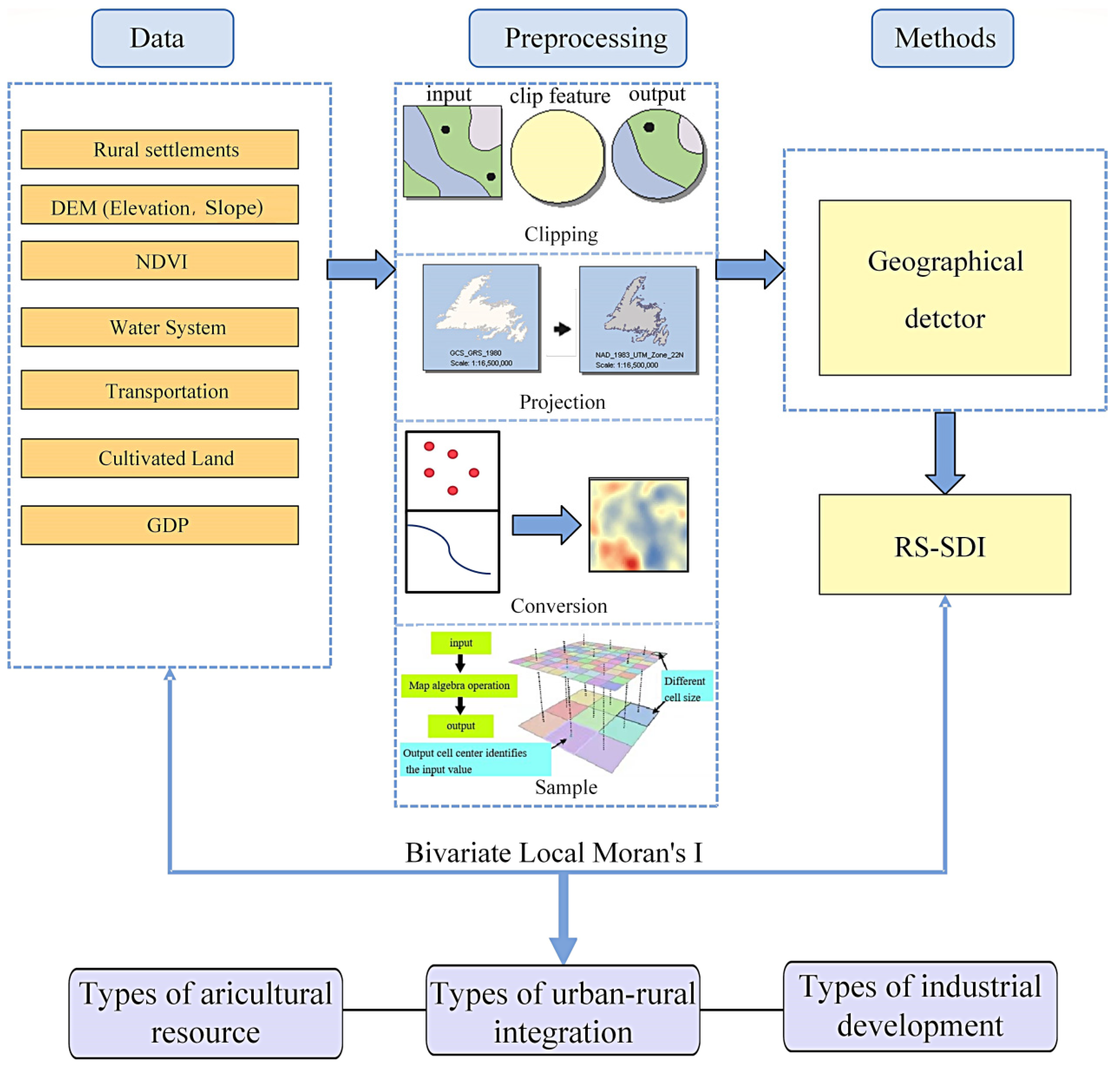
2. Data Collection and Methods
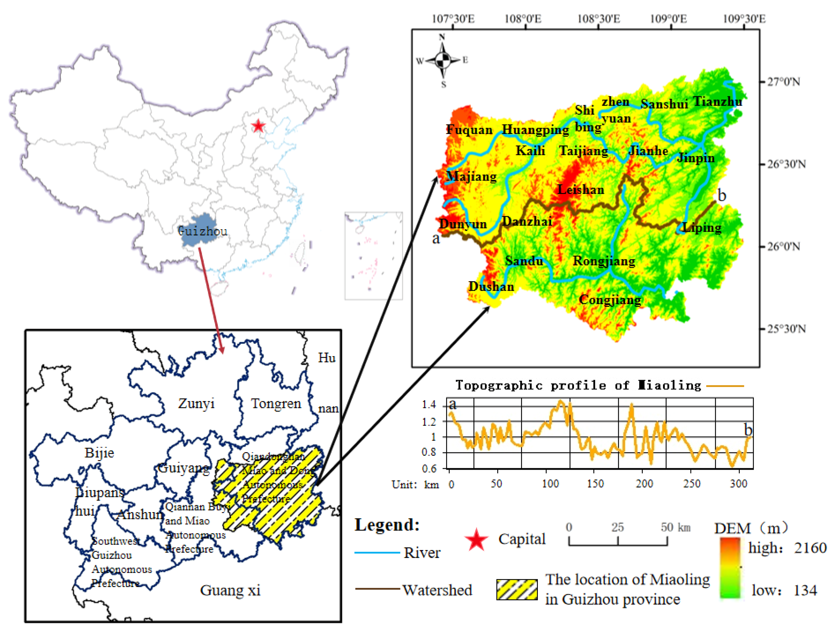
2.1. Study Area

The terrain in the Miaoling Mountains in southwestern China is complex and high. The eastern part is severely cut, and the surface undulates. The western part consists of karst mountains, an inter-mountain dissolution basin, and Ping Yi surfaces, and the terrain is gentle. The geological relics in the area are diverse and have a high scientific and aesthetic value. This area was approved as a national geopark in 2009 [24]. Taking into account the geological and geomorphological background, the spatial integrity of the watersheds to the north and south, and the culture of the indigenous people, the study area was defined as the Miaoling watershed, which starts in Huishui in the west, passes through Leishan, and reaches Jinping in the east (26°31.599′–26°34.505′ N, 107°19.497′–109°6.121′ E). The highest elevation is the prominent peak of Leigong Mountain, and the lowest point is where the Duliu River exits Guizhou (the lowest point in Guizhou Province) (Figure 1).
The study area is dominated by the Qiandongnan Miao and Dong Autonomous Prefecture, which covers 19 county-level administrative regions (including 14 national-level poor counties), including Kaili City, Majiang County, and Leshan County, with a total area of 3.03 million km2, a population of 418.06 million, and a total of 198,100 rural settlements, with an urbanisation rate of 45.55%. According to the 2021 Statistical Yearbook of Qiandongnan Prefecture, the population of ethnic minorities in the region accounts for 81.7% of the state’s population, including the Miao, Dong, Buyi, Yi, and Gelao ethnic groups, which are hereditary, with the Miao accounting for 43.33% and the Dong for 30.44% of the population, making it the largest concentration of Miao and Dong ethnic groups in China. In terms of economic development, the GDP of Qiandongnan Prefecture ranks 8th among the nine cities and states in Guizhou Province, with the primary, secondary, and tertiary industries accounting for 15.7%, 23.1%, and 61.2% of the GDP, respectively. The economic development gap between counties reaches across the region, for example, Kaili city’s GDP in 2021 is about seven times that of Shibing county, and the tertiary industry in the region is most developed in Kaili city and Leishan county.
At present, the Miaoling Mountains suffers from fragmented arable land, thin soil layers, poor agricultural production conditions, low levels of industrialisation and urbanisation, backward infrastructure, weak urban–rural links, underdeveloped ethnic cultural industries, under-utilised resources with ethnic characteristics, difficulties in employment, and low income for rural residents, and is a particular hardship area with a concentrated and contiguous distribution of poor people across the country. Therefore, evaluating the sustainable development of rural settlements in the Miaoling mountainous is of great significance in promoting the sustainable development of the rural stock in the region.

2.2. Data Collection

In this study, the 2020 Sky Map and Gaofen-1 and Gaofen-2 remote sensing images were used to form a multi-source remote sensing dataset with a spatial resolution of better than 3 m covering the study area. This dataset was combined with 1:50,000 digital topographic maps (DLGs) in the ArcGIS platform to unify the coordinate system, interpretation marks, and data accuracy, and the data on the spatial distribution of the rural settlements in the study area were extracted through human–computer interactive interpretation. After two field verifications in August and October 2020, the accuracy of the data was greater than 90%, and the spatial data for the rural settlements in the study area were finally obtained. The 1:50,000 digital topographic map data were used to produce digital elevation model (DEM) data with a horizontal resolution of 20 m and a vertical resolution of 2 m using the ArcGIS 10.2 spatial analysis module. Based on this, the slope data were extracted. The GDP data with a resolution of 1 km and NDVI data with a resolution of 30 m were obtained from the Resource and Environment Science and Data Centre of the Chinese Academy of Sciences.

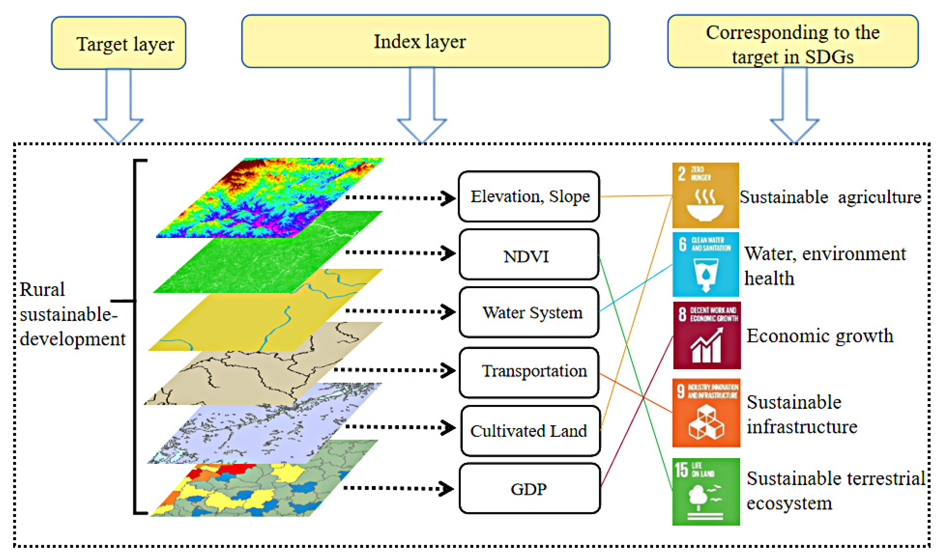
2.3. Construction of Evaluation Index System

2.3.1. Index System Construction

The United Nations Sustainable Development Goals (SDGs) contain 17 sustainable development goals and 169 targets, covering three dimensions of development: social, economic, and environmental [25]. To follow the principles of representativeness, scientificity, and accessibility of indicators, this study was conducted based on the current development situation of the rural settlements in the Miaoling Mountains. In the context of SDG 2: “Eradicate hunger and promote sustainable agriculture”, SDG6: “Provide access to and sustainably manage water and sanitation for all”, SDG8: “Achieve sustained, inclusive and sustainable economic growth and promote productive employment”, SDG9: “Build disaster-resilient infrastructure and promote inclusive and sustainable industrialization”, and SDG15: “Protect, restore and promote sustainable use of terrestrial ecosystems, sustainably manage forests and enhance biodiversity”. In addition, seven indicators, including elevation, slope, cultivated land, water system, transportation, GDP, and NDVI (Table 1), were selected from the social, economic, and environmental aspects to build a system of indicators for evaluating the sustainable development of the rural settlements in the Miaoling Mountains (Figure 2) to ensure that the sustainable development of the rural settlements in the Miaoling Mountains can be reflected in a relatively comprehensive manner.

2.3.2. Methods

(1)
Geographical detector method
The Geographical detector is a new statistical method for detecting geospatial heterogeneity and revealing the driving factors behind it [26]. The core idea is that if the study area is divided into sub-regions, spatial heterogeneity exists if the sum of the variances of the sub-regions is less than the total variance of the site. If the spatial distribution of the two variables converges, they are statistically related [27,28]. In this study, a geographical probe was used to detect the relationships between the factors and the rural settlements in order to determine the weights of each influencing factor. The equation is as follows:
P D , G = 1 - 1 N σ H 2 i = 1 m ( N D , i σ G D , k 2 )
where PD,G is the power of indicator D to detect the distribution of H in the rural settlements, n and σ2 are the total number of samples and the variance of the entire study area, m is the number of classifications of a factor, and ND,i is the number of samples (i = 1, 2, 3, …, m) within indicator D (corresponding to one or more sub-regions). PD,G is the indicator of the power of spatial heterogeneity of the rural settlements, and its range is [0,1]. When PD,G = 0, the rural settlements are randomly and irregularly distributed, and indicator D does not influence the spatial heterogeneity of the rural settlements. The larger the value of PD,G is, the greater the influence of indicator D on the spatial heterogeneity of the rural settlements.
According to the results of the geographical probe (Table 2), the spatial distribution of the rural settlements in the Miaoling Mountains is mainly influenced by seven factors in the following order: GDP > Cultivated land > Elevation > Slope > NDV > Water system > Road.
(2)
RS-SDI
The sustainable development evaluation index mainly takes into account the regional economy, topography and landscape, ecological environment, and other factors by using a comprehensive weighting method to calculate the level of sustainable development of the rural settlements in the Miaoling Mountains. The greater the sustainable development index is, the better the development prospects of the rural settlements are. The equation is as follows:
R S - S D I = i = 1 m w j × δ ( k ) ,
where Wj denotes the weight of each indicator, δ (k) is the corresponding value of the rural settlement impact factor, and m is the total number of indicators. The RS-SDI was first normalised using the sustainable development assessment value and was calculated using the raster calculator in ArcGIS. It was divided into five classes using the natural breakpoint method (Table 3).
(3)
Bivariate Local Moran’s I
The bivariate Local Moran’s I is based on global spatial autocorrelation, which is used to identify the possible spatial association patterns of two variables in different spatial locations, to accurately grasp the aggregation and divergence characteristics of the local spatial elements, and provide a basis for classification and decision-making [29,30]. In this study, the Geoda spatial analysis tool was used to build a spatial weight matrix in order to determine whether there is a positive spatial correlation between the level of sustainable development in the Miaoling Mountain villages and each influencing factor of high-high clustering type (HH) or low-low clustering type (LL), a negative spatial correlation of high-low clustering type (HL) or low-high clustering type (LH), or no significance. The equation is as follows:
I l m P = z l p q = 1 n W p q z m q ,
where z l p = X l p X i ¯ σ l , and z m q = X m q X m ¯ σ m . X l p is the value of the attribute l of space cell p; X m q is the value of attribute m of space cell q; and X ¯ l and X ¯ m are the averages of attributes l and m respectively. σ l and σ m are the variances of attributes l and m, respectively. Wpq denotes the weight matrix created based on the spatial adjacency relationships. The Moran’s I was standardised as follows:
Z ( I ) = I E ( I ) var ( I ) ,
where E(I) is the expected value and var(I) is the variance.

2.4. Research Principles and Processes

The countryside is a complex territorial system composed of social, economic, and environmental elements with a particular spatial organization [31]. The sustainability of rural settlements determines the possibility of creating economic and social values and achieving a harmonious coexistence between humans and nature. Evaluations of the sustainability of rural settlements have revealed that rural areas generate diversified functions and meet diversified regional needs [32]. In this study, the sustainable development level of rural settlements in the Miaoling Mountains was assessed from multiple perspectives using topography, NDVI, water systems, roads, cultivated land, and GDP data. After pre-processing the data, a geographic probe method was used to determine the weights and calculate the RS-SDI. Bivariate local autocorrelation was applied to reveal the level of sustainable rural development and the logical relationships between the factors in order to discuss the typical patterns of sustainable rural development and to develop optimization strategies Figure 3.

3. Results

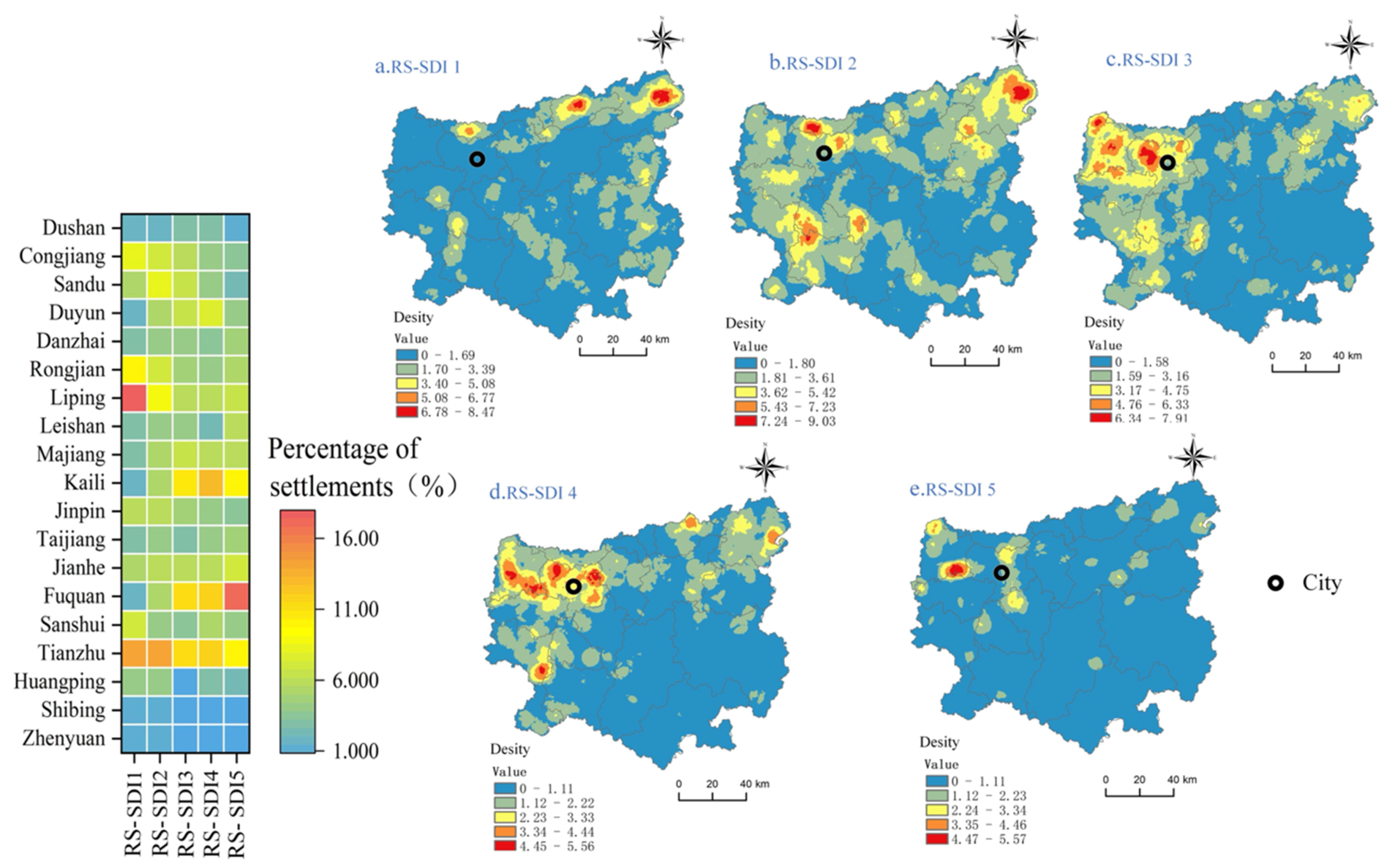
3.1. Hierarchical Characteristics and Spatial Patterns of the RS-SDI in the Miaoling Mountains

Among the five levels of the sustainability index, the number of RS-SDI1 to RS-SDI5 settlements accounted for 21.13%, 32.74%, 24.93%, 15.53%, and 6.67%, respectively. Among them, the clusters with RS-SDI1, RS-SDI2, and RS-SDI3 accounted for 78%, which shows that the sustainable development level of the rural settlements in the Miaoling Mountains is generally low to medium. Regarding the spatial patterns (Figure 4), there is apparent spatial heterogeneity in the sustainable development hierarchy of the Miaoling mountain villages. The RS-SDI1 settlements are mainly located in eastern Tianzhu, central Sansui, and Huangping, with the most significant number of accommodations in Liping (18%) and Tianzhu (14%) and the smallest number in Kaili (2%) and Shiping (1%). The RS-SDI2 settlements are primarily located in eastern Tianzhu, Huangping, and the border region between Danzhai and the Sandu Shui Autonomous County, with the highest number of accommodations in the county consistent with RS-SDI1. The RS-SDI3 and RS-SDI4 rural settlements tend to be spatially invariant, with high-density values occurring around urban areas with sound economic development, such as Kaili City and Fuchuan City, and the proportion of settlements is >10%. In addition, the RS-SDI5 values are mainly concentrated in the south-eastern part of Fuquan City and the western part of Kaili City, where the levels of industrial and economic development are good, and the proportion of rural settlements is 17%. The rural settlement expenditures account for 17% and 10%, respectively. In summary, the medium to high-level sustainable settlements tend to be distributed around urban areas, while the low sustainability level territories are scattered.

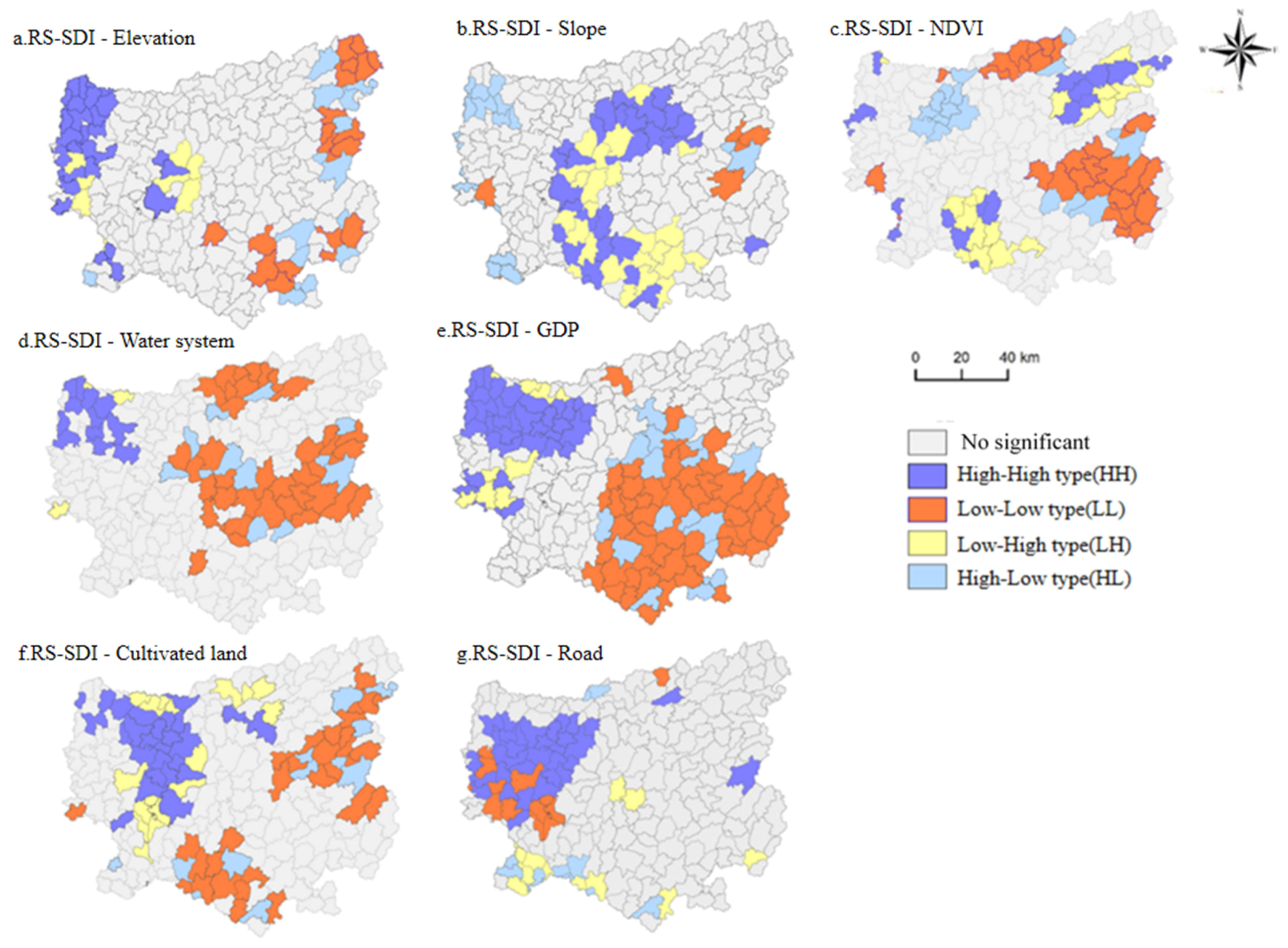
3.2. Sustainable Development Levels of the Rural Settlements in the Miaoling Mountains under Different Influencing Factors

According to the autocorrelation scatter plot for RS-SDI, for each factor in the Miaoling Mountains (Figure 5), it can be seen that the GDP (0.993), cultivated land (0.983), elevation (0.417), NDVI (0.243), water system (0.299), and road (0.143) all exhibit positive correlations in space, while the slope (−0.07) exhibits a negative correlation. Among them, the GDP, cultivated land, and elevation exhibit strong correlations, while the remaining factors exhibit relatively weak spatial correlations.
In order to further analyse the relationships between the rural sustainability index and the seven factors, a table of the spatial autocorrelation types (Table 4) and the corresponding spatial correlation clustering map (Figure 6) at the township scale were obtained to reflect the spatial distribution characteristics of the rural sustainability level and the respective correlation types from both the natural environment and socio-economic aspects. At p < 0.05, most rural settlements exhibited a non-significant type of spatial epistasis, with a confidence level of 95%.

3.2.1. Influences of the Natural Environmental Factors on the Level of Sustainable Development of the Rural Settlements

The local spatial autocorrelation of the natural environment factors is presented in Table 4 and Figure 6, with the HH and LL types of the RS-SDI and elevation including 28 and 26 townships, respectively, accounting for 13% and 10% of the total number of settlements. Among them, the HH type areas are mainly distributed in the townships of Machangping and Niuchang in Fuquan City and Baimang in Duyun City, which are located at higher elevations, receive sufficient sunshine, have fertile land, and are located close to rivers, making them suitable for growing all kinds of crops, including economic crops. Baishi Town and Lantian Town in the eastern part of Tianzhu County are typical LL-type areas. Although they are situated at lower elevations and have smaller slopes, they are mostly dominated by low hills and gully landscapes with large undulations. They lack large areas of dammed flat land used for agricultural cultivation. The RS-SDI and slope HH, and LL types include 30 and 7 townships, respectively, accounting for 11% and 2% of the total number of settlements; while the LH and HL types include 25 and 18 municipalities, respectively, accounting for 16% of the total number of settlements. The HH and LH types are distributed in a C-shape and are concentrated in the central part of the Miaoling Mountains.
In contrast, the LH type is mainly located in Jiabang in Congjiang County, Wangfeng in Leishan County, and Paitiao in Danzhai County, where the hills are steep and traditional agriculture is the mainstay. The RS-SDI and NDVI HH and LL areas include 17 and 31 townships, respectively, accounting for 8% and 11% of the rural settlements, while the LH and HL areas include 18 and 17 municipalities, respectively, accounting for 7% and 9%. Among them, the HH type is mainly scattered in the townships of Min-dong and Nanjia in Jianhe County and Yuankou in Tianzhu County, where the forest coverage rate of Min-dong and Yuankou reaches over 70%. The ecological tourism industry is well developed. The HL type is mainly distributed in the townships of Sankeshu and Wanshui in Kaili, which are close to urban areas, have relatively good economic development levels, are more affected by human activities, and have lower vegetation coverage. The HH and LL types of the RS-SDI and water systems include 13 and 38 townships, respectively, accounting for 8% and 15% of the total number of rural settlements. Spatially, the HH type tends to be consistent with the Elevation HH type. Zhaoxing and Yongcong in Liping County are located far away from the Miaoling watershed’s water sources. They are also situated in sloping areas with poor land and limited development, so they are LL type.

3.2.2. Socio-Economic Influences on the Level of Sustainable Development of Rural Settlements

The local spatial autocorrelation of the socio-economic factors shows that the HH and LL types of the RS-SDI and GDP include 125 and 37 townships, respectively, both accounting for 19% of the total number of settlements. In comparison the LH and HL types include 10 and 17 townships, respectively, together accounting for only 12% of the total number of settlements. These townships have good socio-economic development conditions and typical industrial development. The LL type is mainly concentrated in Xiutang in Congjiang County, Pingyong in Rongjiang County, and Maogong in Liping in the south-eastern part of the Miaoling Mountains. These areas have long, narrow canyons, with little public land, poor transportation, and relatively poor economic development. The HH and LL types of the RS-SDI and arable land are located in 29 and 31 townships, accounting for 16% and 10% of the total number of settlements. In comparison, the LH and HL types are located in 17 and 12 townships, accounting for 14% of the total number of settlements. The HH type is mainly located in Lushan in Kaili City and Paitiao in Danzhai County, where the soil fertility is high due to the mild climate and abundant precipitation. The LL type is mainly located in Sanjiang in Jinping County and Dehua in Liping County where there are more hills and gully slopes and less flat dammed areas and arable land. The HH and LL types of the RS-SDI and roads include 33 and 12 townships, respectively, accounting for 18% and 3% of rural settlements, while the LH and HL types include 13 and 11 municipalities, respectively, accounting for 7% and 2%. The LL type is typical of the townships around Kaili City and Fuquan City.

4. Discussion

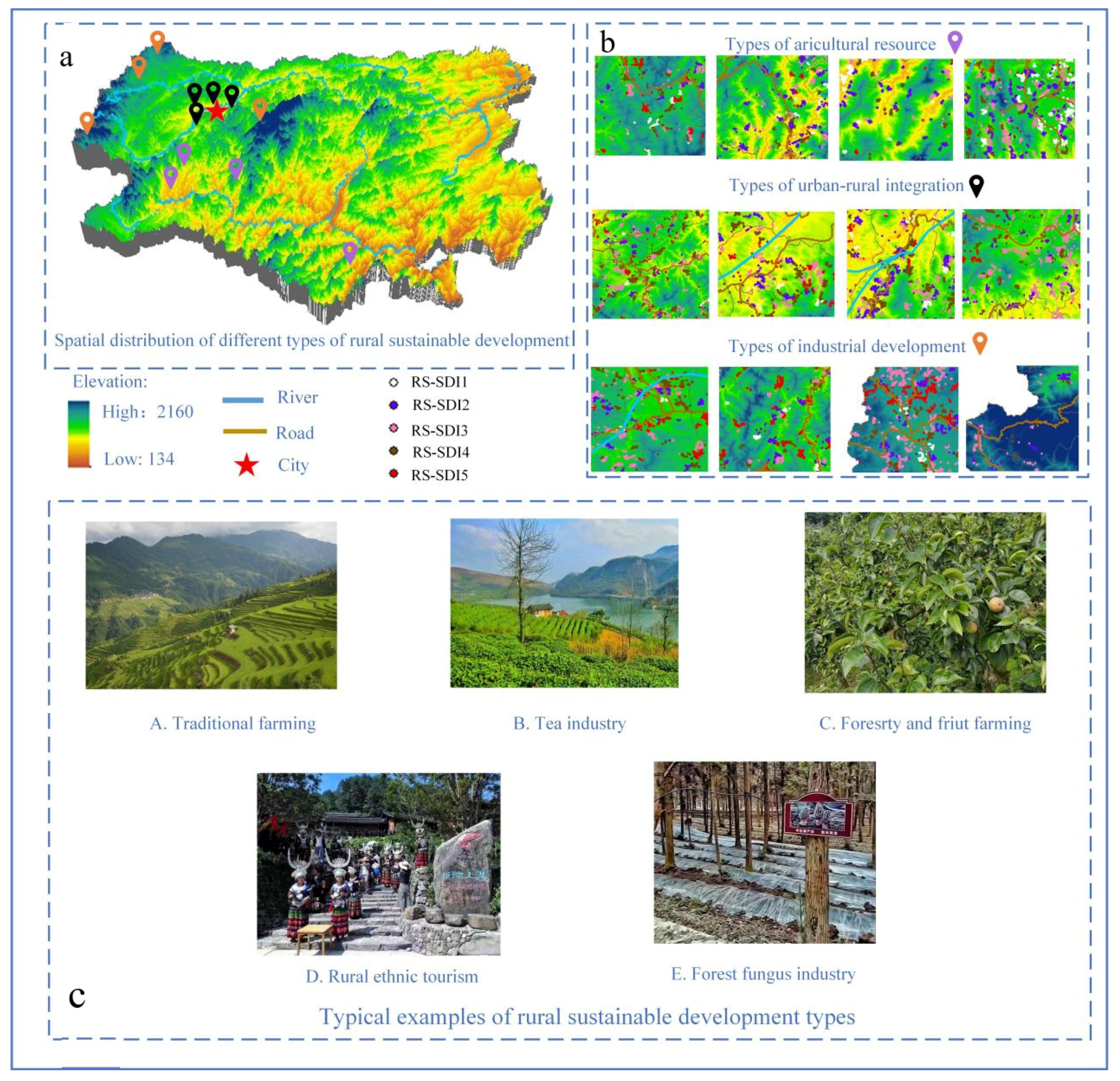
4.1. Classification of Rural Sustainable Development Level Typologies Based on Local Autocorrelation

Based on the above-presented results of the spatial autocorrelation between the sustainable development level of the rural settlements and natural and socio-economic factors in the Miaoling Mountains, the rural settlements were classified into three categories via spatial superposition coupling: agricultural resource-based, urban-rural integration-based, and industrial development-based settlements (Table 5, Figure 7).
(1)
Agricultural resource-based type
The agricultural resource-based type settlements are mainly located in Wangfeng Township, Paidiao Township, and Jiabang Township, with a rural sustainable development index of 0.34. These areas are characterised by mountainous terrain, fertile land, and sufficient water for irrigation, and rice cultivation is the mainstay of the traditional farming, and the majority of the settlements are traditional settlements. Due to the constraints of the natural background and traffic conditions, the location conditions and internal development are at a disadvantage, with a weak capacity for self-renewal. The industrial advantages are not obvious due to a lack of the necessary conditions for industrial development. The level of economic growth is relatively low.
(2)
Urban-rural integration-based type
Typical example of urban-rural integration-based villages are Sankeshu, Yatang and Wanchao, with a sustainable development index of 0.39. Spatially, they are close to the city centre, and they are functionally closely linked to the urban areas. The majority of villages of this type are located in areas with relatively flat terrain, and some have rivers passing through them. They are characterised by more arable land, convenient transport, a relatively high level of urbanisation, a better level of economic development, and more favourable location conditions. The rural development in this type of settlement is mainly influenced by urban radiation and a strong complementarity status between urban and rural industries. The demand for labour is high, but the impact of human activities is strong, and the vegetation cover is low.
(3)
Industrial development-based type
The industrial development-based type villages are mainly represented by the townships of Machangping, Langde, and Baimang, with a sustainable development index of 0.4. These areas are blessed with a unique geographical location, high resource endowment, and high development potential. They rely on primary, secondary, and tertiary industrial resources, such as minority cultures, the ecological environment, mineral resources, and large-scale cash crops as development advantages to provide support for sustainable rural development, for example, the ten thousand acres of orchards in Machangping Town; the ethnic and ecological tourism in Langde Town, Leishan County; the development of the Wengfu phosphate mine in Niuchang Town; and the tea industry and processing in Baimang Township, Duyun City. This type of rural settlement has a strong resilience and a strong capacity for self-renewal, providing products and services mainly for urban residents.

4.2. Strategies for Optimising the Sustainable Level of Rural Settlements

China is in a critical transition from a secular society to a post-material society, which is also the case in the Miaoling Mountainous. The sustainable development model of rural settlements in the Miaoling Mountainous is inevitably combined with social reality and the needs of the inhabitants. In China, the construction of villages, an important task of the rural revitalisation strategy, is a crucial element of the country’s modernisation [33]. Combining the influence of natural and human factors on the level of sustainable rural development and based on the current situation of rural settlements in the Miaoling Mountains, the following strategies can be proposed to improve their sustainable rural development: (1) Give full play to the government’s macro-control functions to safeguard the government’s role in planning guidance, policy support, and organisational safeguards [34]. Firstly, the government encourages rural residents to transfer their land management rights by way of policy guidance in order to participate in rural cooperatives and reach intensive land use; secondly, it strengthens the flow of capital and technology to rural areas, focusing on supporting villages with excellent resource endowment conditions and promoting the market-oriented development of rural areas. (2) Adhere to the integrated development of the countryside, make full use of the leading role of advantageous development villages, and promote the market-oriented development of villages with weak development capacity [35]. Delineate the boundaries of various types of spatial control, optimise the spatial layout of production, living, and ecology in the countryside, strengthen the protection of ecology and arable land, and enhance their sustainable development potential. (3) Give full play to potential resources for sustainable development in the countryside [36], such as superior ecological environment and unique ethnic culture, and insist on a market-oriented, development and conservation-oriented, infrastructure-building-based tourism destination that integrates ecological and ethnic cultural tourism, promoting the economic development of rural areas and the revitalised use of ethnic cultural resources.

4.3. A Comparative Study of the Factors Influencing Sustainable Rural Development

The sustainable development of the mountainous countryside is a crucial concern of national and local governments, and the achievement of sustainable development in rural areas can effectively contribute to the improvement of the region’s economic development and the quality of life of its inhabitants. First, as an important ecological barrier in China, the Miaoling Mountains have complex terrain. Most villages are closed to traffic, leading to a long-term development lag. However, due to the low level of external interference, the high degree of integrity of rural settlements in the region, the vital authenticity of ethnic culture and the apparent traditional production and lifestyle create opportunities for the development of local ecological agriculture and ethnic cultural tourism. Furthermore, policy leadership significantly promotes local economic development and farmers’ living standards and achieves the preservation of the ecological environment and ethnic culture. In India, the scattered rural settlements and poor infrastructure in the southern Himalayan Mountains, as well as the problems of monsoon climate instability and productivity-induced ecological-spatial variability, have been maintained through innovative technologies and institutional arrangements to maintain ecologically sound mixed farmland-agroforestry patterns. This has resulted in substantial economic benefits and increased the efficiency of resource and labour utilisation [37]. The Ukrainian Carpathian countryside, which is overly dependent on the tourism value of the forest landscape at the expense of the diversity of the countryside’s territorial structure, has adopted multifaceted maintenance from the economic production, ecological functions, and social and cultural aspects to promote environmental protection and sustainable use of the forest resources [38]. The mountain villages in Korea are restricted by their topography and are experiencing rapid decline due to the deterioration and ageing of the village population, reduction of the scale of agricultural operations, decrease in agricultural income, and overuse of forest resources. Thus, local use of forest playgrounds, cultivation of forestry products, expansion of the scale of the agroforestry business, and improvement of educational and welfare facilities are used to preserve the unique culture and ecosystem of these mountain villages and to balance land development. The forest resources require effective management of forest resources [39]. The Yao Mountain villages in Thailand are dominated by singular traditional agriculture, and the blind pursuit of economic benefits has led to the harmful effects of long-term fertiliser abuse and the need to root the agricultural industry in ecological, economic, and social priorities, as well as restoration of the traditional culture, in the subsequent sustainable development process [40]. In Romania, the countryside in the Apsenian Mountains needs to be rehabilitated by strengthening infrastructure and tourism development in order to reduce the exodus of people and improve the quality of life and economic development due to the constraints of the mountainous environment, which have lea to under-capitalisation, limited access to information about development opportunities, and the environmental vulnerability caused by over-reliance on mining activities [41]. In the rural areas of the Bolivian Andes, where poverty rates are high, the infrastructure is poor, mixed farming is predominant, and soil erosion is severe, farmers in rural areas have organised themselves to conserve soil and water in order to improve land productivity, which has led to the conservation of much of the area and laid the foundation for sustainable development [42].
As mentioned above, sustainable rural development is an important means of combating regional poverty and promoting economic development [43]. However, there are differences in the patterns of sustainable rural development between regions due to differences in the natural environment and socio-economic factors:
(1)
Natural constraints, mainly in terms of topography, soil quality, and effective use of resources, are important reasons for the low level of sustainable development in mountainous villages.
(2)
Social factors related to transport, agricultural practices, and the backward or deformed development patterns of rural areas due to the blind pursuit of economic profit further limit their sustainable development. At the same time, there are certain similarities in the policies adopted by each region to address the sustainable development of rural areas.
(3)
Top-down policy guidance has provided direction for sustainable rural development and facilitated the transition to sustainable development.
(4)
Bottom-up community involvement further contributes to the transition to sustainable development in each region, as in the case of soil and water conservation initiatives initiated by the inhabitants of the Andean countryside.

4.4. Limitations and Prospect

Sustainable development evaluation is a complex task that requires the selection of indicators from a multidimensional perspective involving the social, economic, and environmental aspects. In this study, the GDP, arable land area, elevation, slope, NDVI, water system, and roads were selected to assess the level of sustainable rural development in the Miaoling Mountains, and local spatial autocorrelation was conducted to reveal further the logical relationships between the level of sustainable development and the natural environmental and socio-economic factors. However, there are two limitations as follows: (1) In terms of limitations in obtaining data for the study, as the subject of this study is to assess the level of sustainable development of rural settlements in the Miaoling Mountains, there are still some rural settlements in the region with low accessibility, making it difficult to conduct field surveys in these settlements. Furthermore, the GDP data used were 1 km × 1 km raster data. This resulted in some settlements having the same GDP values, which affected the accuracy of the conclusions. (2) Regarding the selection of indicators, this paper only selects socio-economic indicators such as arable land, roads, and GDP, and to a certain extent, lacks social pillar indicators. As mentioned in Section 2.1 of this paper, the Miaoling mountainous region is the largest Miao and Dong ethnic group settlement in China, where the combined Miao and Dong population accounts for 73.77% of the population, with a high degree of inter-ethnic communication and integration, and relatively low socio-cultural differences. However, the findings are still highly scientific and accurate and can provide practical reference and guidance for the sustainable development process of rural settlements in the Miaoling Mountains.
Ethnic culture and willingness to develop are important factors influencing the development of rural settlements in the Miaoling Mountains of southwest China and [44], to a certain extent, determine the progress of sustainable development in the Miaoling Mountains, which, in addition to the Miao and Dong ethnic groups, also contain other ethnic minorities such as the Buyi, Gar, and Gelao ethnic groups. Therefore, in the following research project, the authors will further analyse and evaluate the sustainable development of rural settlements in the Miaoling Mountains, taking into account the spatial distribution of ethnic minorities, social culture, willingness to develop, and the quality of the ethnic population.

5. Conclusions

The methodology of this study was based on the calculations used to evaluate the sustainable development of rural settlements in Liangshan, Yunnan Province, China [45]. However, in this study, Miaoling, the largest Miao settlement in China, was selected as the study area, and the method described in this paper was applied. Regarding selecting the selection of the factors, the roads and water system factors were added according to the rural development situation in the Miaoling Mountains. Bivariate spatial autocorrelation analysis was added to the methodology, which more intuitively reflects the relationships between the development level of the rural settlements and the seven factors. The logical connection between the seven factors was more intuitively reflected in the bivariate spatial autocorrelation analysis. Then, spatial superposition coupling was used to classify the clusters with different RS-SDI levels under the influence of each factor and an optimisation strategy was developed. Finally, the following conclusions were drawn.
(1)
The sustainable development level of the rural settlements in the Miaoling Mountains is generally at the lower end of the medium level. There is apparent spatial heterogeneity among villages with different levels of sustainable development, with the high sustainable development settlements tending to be distributed around urban areas while the low sustainable development settlements are scattered.
(2)
The bivariate spatial autocorrelation analysis between each influencing factor and the level of sustainable rural development revealed that the GDP, arable land area, elevation, NDVI, water system, and roads all exhibited positive spatial correlation, while the slope exhibited a negative spatial correlation. In the local autocorrelation analysis, the bivariate local autocorrelation of RS-SDI with each factor exhibited certain characteristics. However, in general, there was a certain spatial similarity, with the HH and LL type settlements primarily located in the form of clusters. The HH type settlements were mainly concentrated in the north-western part of the Miaoling Mountains in the towns and villages around the cities with sound economic development and obvious socio-economic advantages. In contrast, the LL type settlements were concentrated in the south-eastern and central parts of the Miaoling Mountains in the hills and the slopes of gullies. The LH and HL type settlements were sporadically distributed, and the development trend of the intensification and aggregation was not noticeable.
(3)
Based on the local spatial autocorrelation analysis results, the rural settlements were classified into three categories, i.e., agricultural resource-based, urban-rural integration-based, and industrial development-based settlements, and optimised, sustainable development strategies were developed for each of these three categories.

Author Contributions

M.Y., M.L. and Q.T. conducted field research and developed thesis framework definition. Y.Q. developed methods, organized data, performed formal analyses, and wrote and prepared the original manuscript. Y.L., G.L. and C.Z. reviewed and edited the manuscript. Funding received by J.L. and G.L. All authors participated in the drafting of the manuscript. All authors have read and agreed to the published version of the manuscript.

Funding

This research was funded by the National Natural Science Foundation of China, grant number (No:42061035); by Guizhou Science and Technology Plan (No: [2020]1Y157); by Guizhou Science and Technology Cooperation Platform Talents (No: [2021]A22 and [2017]5726–54).

Institutional Review Board Statement

Not applicable.

Informed Consent Statement

Not applicable.

Data Availability Statement

Not applicable.

Conflicts of Interest

The authors declare no conflict of interest.

References

  1. Brundtland, G.H. What is sustainable development. In Our Common Future; Oxford University Press: New York, NY, USA, 1987; Volume 8. [Google Scholar]
  2. Anand, S.; Sen, A. Human development and economic sustainability. World Dev. 2000, 28, 2029–2049. [Google Scholar] [CrossRef]
  3. Islam, R.M.; Barr, E.; Gregg, E.W.; Pavkov, M.E.; Harding, J.L.; Tabesh, M.; Koye, D.N.; Shaw, J.E. Trends in incidence of total or type 2 diabetes: Systematic review. BMJ Clin. Res. 2019, 366, 1. [Google Scholar]
  4. Bogale, A.; Shimelis, A. Household level determinants of food insecurity in rural areas of Dire Dawa, Eastern Ethiopia. AJFAND 2009, 9, 3. [Google Scholar] [CrossRef]
  5. Qayyum, W.; Siddiqui, R. Causes of youth unemployment in Pakistan [with comments]. In PDR; Pakistan Institute of Development Economics: Islamabad, Pakistan, 2007; pp. 611–621. [Google Scholar]
  6. Mboumboue, E.; Njomo, D. Potential contribution of renewables to the improvement of living conditions of poor rural households in developing countries: Cameroon’s case study. Renew. Sustain. Energy Rev. 2016, 61, 266–279. [Google Scholar] [CrossRef]
  7. Boggia, A.; Rocchi, L.; Paolotti, L.; Musotti, F.; Greco, S. Assessing Rural Sustainable Development potentialities using a Dominance-based Rough Set Approach. J. Environ. Manag. 2014, 144, 160–167. [Google Scholar] [CrossRef]
  8. Awojobi, O.N. Sustainable rural development in Nigeria within the context of the Millennium Development Goals. Int. J. Contemp. Appl. Sci. 2014, 1, 58–74. [Google Scholar]
  9. Rahman, K.M.; Edwards, D.J.; Melville, L.; El-Gohary, H. Implementation of bioenergy systems towards achieving United Nations’ sustainable development goals in rural Bangladesh. Sustainability 2019, 11, 3814. [Google Scholar] [CrossRef]
  10. Pasanchay, K.; Schott, C. Community-based tourism homestays’ capacity to advance the Sustainable Development Goals: A holistic sustainable livelihood perspective. Tour. Manag. Perspect. 2021, 37, 100784. [Google Scholar] [CrossRef]
  11. Padda, I.U.H.; Hameed, A. Estimating multidimensional poverty levels in rural Pakistan: A contribution to sustainable development policies. J. Clean. Prod. 2018, 197, 435–442. [Google Scholar] [CrossRef]
  12. Bebbington, A.; Browder, J.O. Fragile lands of latin america: Strategies for sustainable development. Lat. Am. Anthr. Rev. 2010, 2, 23. [Google Scholar] [CrossRef]
  13. Toledo, Á.; Burlingame, B. Biodiversity and nutrition: A common path toward global food security and sustainable development. J. Food Compost. Anal. 2006, 19, 477–483. [Google Scholar] [CrossRef]
  14. Tumushabe, J.T. Climate change, food security and sustainable development in Africa. In The Palgrave Handbook of African Politics, Governance and Development; Palgrave Macmillan: New York, NY, USA, 2018; pp. 853–868. [Google Scholar]
  15. Salvati, L.; Zitti, M. Assessing the Impact of Ecological and Economic Factors on Land Degradation Vulnerability through Multiway Analysis. Ecol. Indic. 2009, 9, 357–363. [Google Scholar] [CrossRef]
  16. Nourry, M. Measuring sustainable development: Some empirical evidence for France from eight alternative indicators. Ecol. Econ. 2008, 67, 441–456. [Google Scholar] [CrossRef]
  17. Phillis, Y.A.; Kouikoglou, V.S.; Verdugo, C. Urban sustainability assessment and ranking of cities. Computers. Comput. Environ. Urban Syst. 2017, 64, 254–265. [Google Scholar] [CrossRef]
  18. Liu, Y.S. Research on the urban-rural integration and rural revitalization in the new era in China. Acta Geogr. Sin. 2018, 73, 637–650. [Google Scholar]
  19. Rahman, K.M.; Edwards, D.J.; Melville, L.; El-Gohary, H. The Research Progress on Typical Areas in China. Prog. Phys. Geogr. 2011, 30, 1538–1547. [Google Scholar]
  20. Sun, Y.; Cheng, Y.Q.; Zhang, P.Y. Spatio-temporal dynamics of rurality in Northeast China. Geogr. Res. 2015, 34, 1864–1874. [Google Scholar]
  21. Cao, Z.; Liu, Y.S.; Li, Y.R.; Wang, Y.S. Spatial pattern and its influencing factors of specialized villages and towns in China. Acta Geogr. Sin. 2020, 75, 1647–1666. [Google Scholar]
  22. Gao, H.J.; Han, H.Q.; Lu, X.Q. Effects of Roads on Rural Settlement Landscape Pattern in Mountain Areas of Southwest China. Areal Res. Dev. 2016, 35, 139–143. [Google Scholar]
  23. Tu, S.S.; Long, H.L.; Zhang, Y.N.; Zhou, X. Process and driving factors of rural restructuring in typical villages. Acta Geogr. Sin. 2019, 74, 323–339. [Google Scholar]
  24. Dong, Y.; Cao, X.J.; Cheng, K.; Tai, T.S.; Hu, X.Q.; Wang, L.L.; Li, Z.H. Eatures of the geological remains of Miaoling National Geopark, Qiandongnan, Guizhou. Chin. J. Geol. Hazard. Ctrl 2010, 21, 129–132. [Google Scholar]
  25. Khoshnava, S.M.; Rostami, R.; Zin, R.M.; Treimikien, D.; Mardani, A. Aligning the criteria of green economy (GE) and sustainable development goals (SDGs) to implement sustainable development. Sustainability 2019, 11, 4615. [Google Scholar] [CrossRef]
  26. Wang, H.; Gao, H.B.; Hou, W.J. Quantitative attribution analysis of soil erosion in different geomorphological types in karst areas: Based on the geodetector method. J. Geogr. Sci. 2018, 73, 1674–1686. [Google Scholar] [CrossRef]
  27. Wang, J.F.; Li, X.H.; Christakos, G.; Liao, Y.L.; Zhang, T.; Gu, X.; Zheng, X.Y. Geographical detectors-based health risk assessment and its application in the neural tube defects study of the Heshun region, China. Int. J. Geogr. Inf. Sci. 2010, 24, 107–127. [Google Scholar] [CrossRef]
  28. Wang, J.F.; Xu, C.D. Geodetector: Principle and prospective. Acta Geogr. Sin. 2017, 72, 116–134. [Google Scholar]
  29. Anselin, L. The local indicators of spatial association—LISA. Geogr. Anal. 1995, 27, 93–115. [Google Scholar] [CrossRef]
  30. Ord, J.K.; Getis, A. Local spatial auto correlation statistics: Distributional issues and application. Geogr. Anal. 1995, 27, 286–306. [Google Scholar] [CrossRef]
  31. Long, H.L.; Liu, Y.S.; Zou, J. Assessment of rural development types and their rurality in eastern coastal China. Acta Geogr. Sin. 2009, 64, 426–434. [Google Scholar]
  32. Clock, P. Rural life-styles: Material opportunity, cultural experience, and how theory can undermine policy. Econ. Geogr. 1996, 72, 433–449. [Google Scholar]
  33. Xi, J.P. Building a Moderately Prosperous Society and Winning the Great Victory of Socialism with Chinese Characteristics in the New Era. People’s Daily 2017, 1–20. [Google Scholar] [CrossRef]
  34. Sutherland, L.A.; Mills, J.; Ingram, J.; Burton, R.J.F.; Dwyer, J.; Blackstock, K. Considering the source: Commercialisation and trust in agri-environmental information and advisory services in England. J. Environ. Manag. 2013, 118, 96–105. [Google Scholar] [CrossRef]
  35. Liu, Y.; Li, J.; Yang, Y. Strategic adjustment of land use policy under the economic transformation. Land Use Policy 2018, 74, 5–14. [Google Scholar] [CrossRef]
  36. Renting, H.; Marsden, T.K.; Banks, J. Understanding alternative food networks: Exploring the role of short food supply chains in rural development. Environ. Plan A 2003, 35, 393–411. [Google Scholar] [CrossRef]
  37. Kanagawa, M.; Nakata, T. Assessment of access to electricity and the socio-economic impacts in rural areas of developing countries. Energy Policy 2008, 36, 2016–2029. [Google Scholar] [CrossRef]
  38. Manhas, A.S.; Singh, P.D.; Salgotra, A.K. Sustainable development for mountain region: A study of Uttarakhand State. Int. J. Appl. Soc. Sci. 2018, 5, 176–181. [Google Scholar]
  39. Elbakidze, M.; Angelstam, P. Implementing sustainable forest management in Ukraine’s Carpathian Mountains: The role of traditional village systems. For. Ecol. Manag. 2007, 249, 28–38. [Google Scholar] [CrossRef]
  40. Kang, H.M.; Kim, H.; Lee, C.H.; Chong, K.L.; Choi, S.I. Changes and development plans in the mountain villages of South Korea: Comparison of the first and second national surveys. J. Mt. Sci. 2017, 14, 1473–1489. [Google Scholar] [CrossRef]
  41. Jian, L. Development and tribal agricultural economy in a Yao mountain village in northern Thailand. Hum. Organ. 2001, 60, 80–94. [Google Scholar] [CrossRef]
  42. Constantin, V.; Ştefănescu, L.; Kantor, C.M. Vulnerability assessment methodology: A tool for policy makers in drafting a sustainable development strategy of rural mining settlements in the Apuseni Mountains, Romania. Environ. Sci. Policy 2015, 52, 129–139. [Google Scholar] [CrossRef]
  43. Kessler, A.; de Graaff, J. Using soil and water conservation contests for extension: Experiences from the Bolivian mountain valleys. Environ. Manag. 2007, 40, 831–841. [Google Scholar] [CrossRef]
  44. Liao, S. Global environmental crises and models of sustainable agricultural development. Chin. Rural Econ. 2003, 16, 675–678. [Google Scholar] [CrossRef]
  45. Zhao, F.; Zhang, S.; Du, Q.; Ding, J.; Xie, Z. Assessment of the Sustainable Development of Rural Minority Settlements Based on Multidimensional Data and Geographical Detector Method: A Case Study in Dehong, China. Socio-Econ. Plan. Sci. 2021, 78, 101066. [Google Scholar] [CrossRef]
Figure 1. Study area.
Land 11 01666 g001
Figure 2. Evaluation system for the sustainable development of rural settlements in the Miaoling Mountains. (SDGs: Sustainable Development Goals).
Land 11 01666 g002
Figure 3. Methodological flow chart. (Note: The images of the clipping and projection parts of the diagram are derived from the illustrations in the Arcgis program).
Land 11 01666 g003
Figure 4. Spatial location characteristics of settlement distribution at different levels of sustainable development. (Note: the left shows the proportion of settlements within the county for different RS-SDI; the maps on the right, a-e, show the spatial distribution of settlements for different RS-SDI).
Land 11 01666 g004
Figure 5. Scatter plot of the autocorrelation between the sustainable development index and various factors in the Miaoling Mountains.
Land 11 01666 g005
Figure 6. Spatially localised spatial correlation aggregation map of the rural sustainable development levels and influencing factors. (Note: Figures (ad) show the relationship between RS-SDI and natural environmental factors; (eg) show the relationship between RS-SDI and socio-economic factors.)
Land 11 01666 g006
Figure 7. Typical examples of rural development types. (Note: (a) General spatial distribution characteristics of different rural sustainable development types; (b) Types of sustainable rural development; (c) Example map of rural development types.)
Land 11 01666 g007
Table 1. Basis for selection of indicators.
IndicatorsBasis of Selection of Indicators
ElevationReflects the elevation of the distribution of rural settlements
SlopeReflects the steepness of the surface unit of the rural settlement distribution site
NDVI
(Normalised Difference Vegetation Index)
Reflects the extent of surface vegetation cover
Water systemReflects the accessibility of water to rural settlements
RoadReflects the accessibility of rural settlements
Cultivated landReflects the primary resources and conditions of survival of the rural population
GDPReflects the social and economic development of rural settlements
Table 2. RS-SDI index weights (RS-SDI:Rural Settlement Sustainable Development Index).
Index GDPCultivated LandElevationSlopeNDVIWater System Road
PD,G value0.39190.28900.18500.07540.03550.02700.0246
Weight0.18 0.170.160.140.130.120.11
Table 3. RS-SDI classification.
RS-SDI1RS-SDI2RS-SDI3RS-SDI4RS-SDI5
0.02–0.200.21–0.280.29–0.380.39–0.510.52–0.99
Table 4. Spatial autocorrelation between the level of sustainable development and the influencing factors in the Miaoling Mountain villages and the number of townships.
Autocorrelation TypeHHLLHLLHNo Significance
Number of TownsPercentage of Rural Settlements (%)Number of TownsPercentage of Rural Settlements (%)Number of TownsPercentage of Rural Settlements (%)Number of TownsPercentage of Rural Settlements (%)Number of TownsPercentage of Rural Settlements (%)
Elevation3112%2210%123%147%17467%
Slope3011%72%259%187%17371%
NDVI178%3111%187%179%16065%
Water system 138%3815%41%114%17772%
GDP3719%5419%105%177%12551%
cultivated land2916%3110%179%215%15460%
Road3318%123%137%112%17470%
Note: p < 0.05 denotes the 95% confidence level, that is, there is a significant spatial autocorrelation between the values of the study subjects.
Table 5. Classification of rural development types based on local autocorrelation.
Sustainable Rural
Development Models
Type of Sustainability AssessmentTypical ExamplesAverage Rural Sustainable Development Index
Agricultural resource-based typeElevation HLWangfeng, Paidiao, Gapeng, Longquan 0.34
Slope LH
Cultivated land HH
Water system HH
GDP LL
Urban-rural integration-based typeGDP HHSankeshu, Yutang, Punhai, Wanchao 0.39
NDVI HL
Cultivated land HH
Slope HL
Road HH
Industrial development-based typeElevation HH
Water system HH
Machangping, Langde, Niuchang, Baimang0.4
GDP HH
Slope HL
Road HH
Water system HH
Publisher’s Note: MDPI stays neutral with regard to jurisdictional claims in published maps and institutional affiliations.

