Article

How to Improve Quality of Crowdsourced Cadastral Surveys

by
Konstantinos Apostolopoulos
* and
Chryssy Potsiou
School of Rural and Surveying Engineering, National Technical University of Athens, 15780 Athens, Greece
*
Author to whom correspondence should be addressed.
Land 2022, 11(10), 1642; https://doi.org/10.3390/land11101642
Submission received: 7 August 2022 / Revised: 11 September 2022 / Accepted: 16 September 2022 / Published: 23 September 2022

Abstract

:
The potential for introducing voluntary citizen participation, combined with mobile services, for cadastral data collection for a systematic first registration has been thoroughly investigated and even implemented in some official projects. This data collection procedure can technically be ac-complished safely, but results have shown that many participants have difficulty in identifying the land parcels (location, shape and size) on the base-map (orthophoto, air-photo, etc.) correctly. Either they have to ask the assistance of a private professional, or there is a high risk that a number of errors may appear in the submitted crowdsourced data. This paper investigates how to improve the quality of such crowdsourced cadastral data, by adding to the base-map any available and relevant geospatial and descriptive information that may help the participants to correctly identify their land parcel. In particular, the research investigates and suggests (a) which types of available geospatial information should be added to the base-map and by whom (professionals or a group of trained volunteers), and (b) the necessary quality controls that must be made in the compilation of the advanced crowdsourced base-map—a case study follows to assess the suggested proposal. In addition, this paper provides an updated version of the crowdsourced methodology for cadastral surveys as modelled by the authors in an earlier stage of their research. This updated version briefly includes all quality controls needed to ensure the quality of a modern cadastre that the authors will further investigate in a subsequent stage.

1. Introduction

Traditionally, landowners indicate on-site the boundaries of their parcels to the land surveyor for the compilation of the cadastral survey. In many other cases, trusted local citizens, too, provide useful historic information for the adjudication of “unknown” landowners and the exact boundaries of these parcels. As technology improves and the use of smart, low-cost devices make the capture of geospatial data an easy practice for many non-professionals, tests have been performed to investigate whether landowners, as well as trusted local citizen in general, may provide contributions toward the first registration using their mobile phones and internet services instead of the traditional method [1,2,3]. This would allow the participation of non-professionals, either on-site or from a distance [4,5], thus significantly increasing the number of participants in cadastral surveying.
The “UN Sustainable Development Agenda 2030” recognized the social, economic and environmental value of cadastres that can serve multiple purposes in society; however, almost 70% of land remains unregistered globally and there is an urgent need for the compilation of cadastral surveys in various countries. As there is no unified model for the methodology to be followed, and taking into account the lack of professionals, the required costs and time for such cadastral surveys at scale, it was early emphasized that the design should be tailored to the capacity and the needs of people and their relationship to land in order to support tenure security for all. As part of this effort, crowdsourcing methodology has been introduced into cadastral surveying to reduce required times and costs, while processes and accuracies achieved may be improved incrementally. This approach is often called a Fit-For-Purpose approach (FFP) [6,7].
The potential for introducing voluntary citizen participation combined with mobile services for data collection for a systematic first registration has been thoroughly investigated in recent years in terms of technical quality [5,8,9,10,11,12,13,14], as well as of methodology [15,16,17]. The introduction of crowdsourcing methodology in cadastres in order to complete full nationwide coverage in developing economies, along with relevant social issues, have also been investigated [1,18,19,20]. These new FFP approaches have been tested and implemented [21,22,23,24,25,26]. Authors in their previous research [2,5,14,17,21] have proved that this FFP crowdsourced methodology may improve the efficiency of cadastral surveying and the process for the adjudication of property owners and their parcels by significantly reducing compilation times, errors and costs. Depending on the methodologies followed, the geometric, thematic and topological quality of the crowdsourced data may vary significantly [17,27,28]. Many studies have investigated the potential of implementing crowdsourcing technology in the cadastral data collection; however, it has not yet been fully investigated as to how to improve the quality of such crowdsourced cadastral surveys [29]. This paper contributes to this field by providing a critical improvement of the basemap to be used for the crowdsourced cadastral surveys.
In [21], a first version of a methodology for achieving reliable crowdsourced cadastral surveys that will satisfy the technical specifications of a modern Accurate, Assured, and Authoritative (AAA) land administration system is published, as described by [30], along with the potential of using gamification elements to achieve more participation and commitment [31]. In addition, in this paper the authors provide the first results of their new research on the required quality control/quality assessment methodology to be introduced into [21] for an incremental improvement of the final quality of the crowdsourced cadastral surveys, moving towards an AAA cadastre.
The ongoing Hellenic cadastral project [32] follows a modern participatory procedure allowing non-professionals/right holders to digitize parcel boundaries through crowdsourcing methodology [33]. However, when participants were asked in Greece to identify their land parcels from a distance and not in the field (e.g., on a basemap, usually an orthophoto) several gross location errors appeared [2] that have caused long delays and extra costs for the project. To overcome such problems, the Hellenic National Mapping and Cadastral Agency (NMCA) has taken the following actions:
(a)
A number of e-services were developed,
(b)
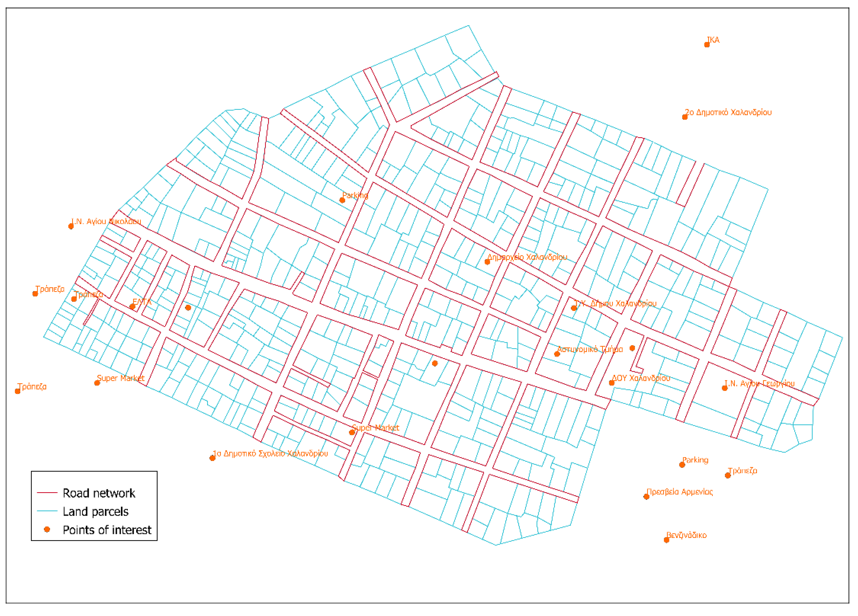
Advanced basemaps, made by professionals, that now include additional geospatial information (e.g., points of interest, street names) are offered to the participants,
(c)
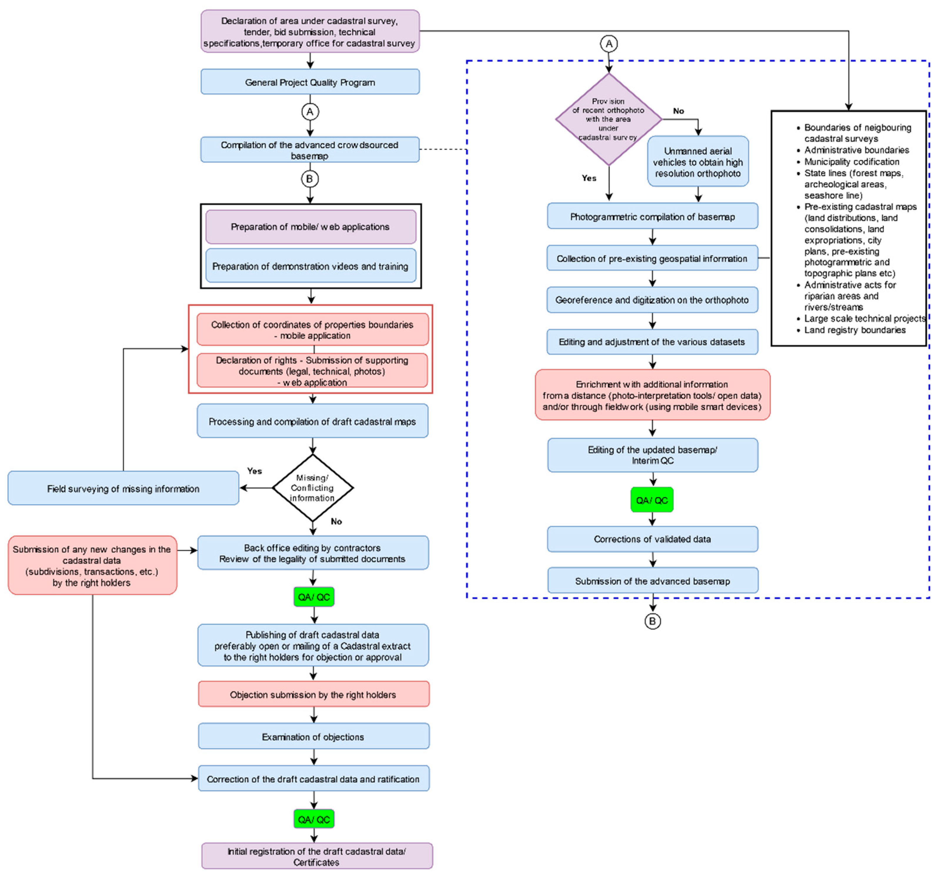
Several automated controls, such as system checks of the submitted data through the declaration process, and provision of a list of errors to ensure the elimination of such in the data collection process from a distance, were introduced [33]. Already to January 2020, more than 750,000 participants have submitted an online declaration (1.1 million declarations in total); this number may well justify the term ‘crowdsourced cadastral surveys’ [33].
This paper focuses on improving the proposed model for crowdsourced cadastral surveying methodology [21]. For this, the authors investigate further the progress achieved in the Hellenic cadastral project in this field.
Section 2 first presents the main stages of the modelled crowdsourced procedure as proposed in [21]. Next, in order to define a methodology for the compilation of an advanced crowdsourced basemap, the main stages for the compilation of the cadastral basemap as well as the necessary controls of the digital cadastral database of the Hellenic Cadastre are investigated (Section 2.1). Section 2.2 presents the updated model for the crowdsourced cadastral surveying methodology. A case study for the compilation of an advanced crowdsourced basemap for a neighborhood in the Chalandri Municipality is accomplished. The concluding section provides an assessment of the proposed methodology.

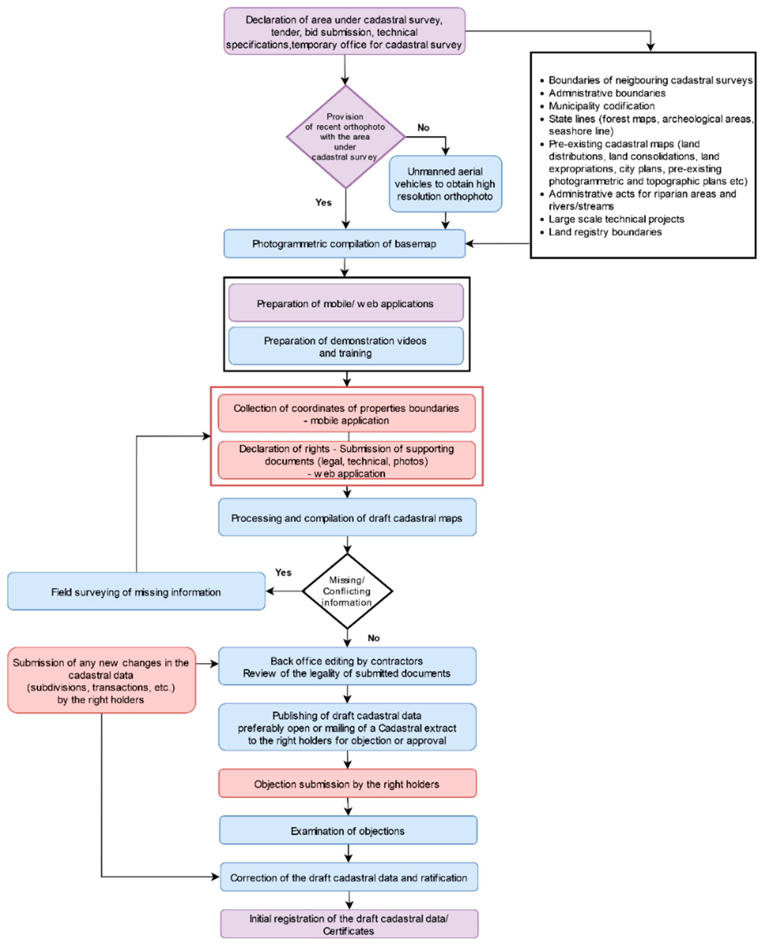
2. Compilation Procedure for an Advanced Basemap for Crowdsourced Cadastral Data Collection

An investigation of two EU current cadastral projects, in Greece and in Romania, provided input for modelling a crowdsourced cadastral surveying procedure that aims at the creation of an AAA cadastre [21].
In principle, according to the proposed model, the contractor (professional surveyor) has the responsibility for monitoring the project, training and supervising the participants/volunteers, providing quality controls, editing the crowdsourced data, providing field measurements when needed, etc.
All right holders and/or local volunteers (a large number of participants), must declare property rights (declarations submission phase), locate and digitize the parcel boundaries on a basemap (a recent orthophoto), and submit those electronically through a mobile or a desktop application. Right holders must also participate in the objections submission phase (depicted in pink in Figure 1).
In the objection phase, right holders are required to correct the identified errors (geometric or attributes). In the case of geometric change of boundaries, all affected neighbors must be informed. If new conflicts with the neighbors are created, a cadastral judge should decide. Following the judgement on the objections, the initial registration of the cadastral data takes place.

2.1. Compilation of the Advanced Basemap in the Hellenic Cadastral Project

This paper aims to improve the model [21] by introducing crowdsourced methodology for the compilation of the cadastral basemap (so far compiled by the contractor-professional surveyor) and quality control of the crowdsourced products. In order to do so, an investigation of the official procedure for the compilation of the advanced basemap for the Hellenic Cadastre is made. The compilation of the Hellenic cadastre is achieved through a partnership between the cadastral agency and the private surveyors. In the first phase of the cadastral surveying, the contractor prepares the advanced cadastral basemap, so that the right holders will be able to better locate their land parcels and submit their declarations. For the compilation of the advanced cadastral basemap, the contractor must use the official orthophoto provided by the Hellenic Cadastre. To that the contractor must add any relevant pre-existing geospatial information (e.g., land parcels and road network) derived from past administrative acts such as ratification of urban plans, urban regeneration projects, land expropriation projects or official definition of the coastal line which actually defines the boundary between private and public land, etc. The advanced cadastral basemap is compiled according to the technical specifications [34] and is submitted according to a regulated time schedule, in order to be checked and validated by the cadastral authority.

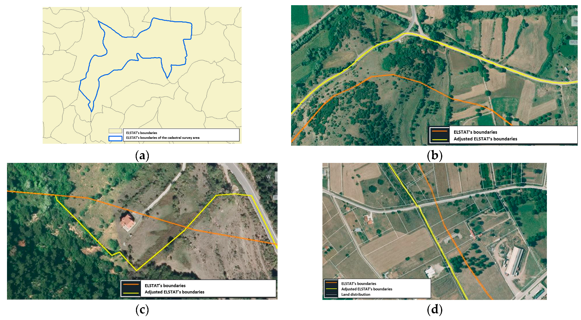
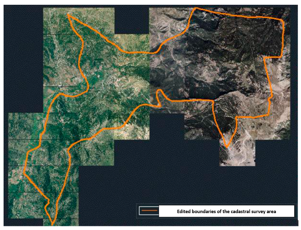
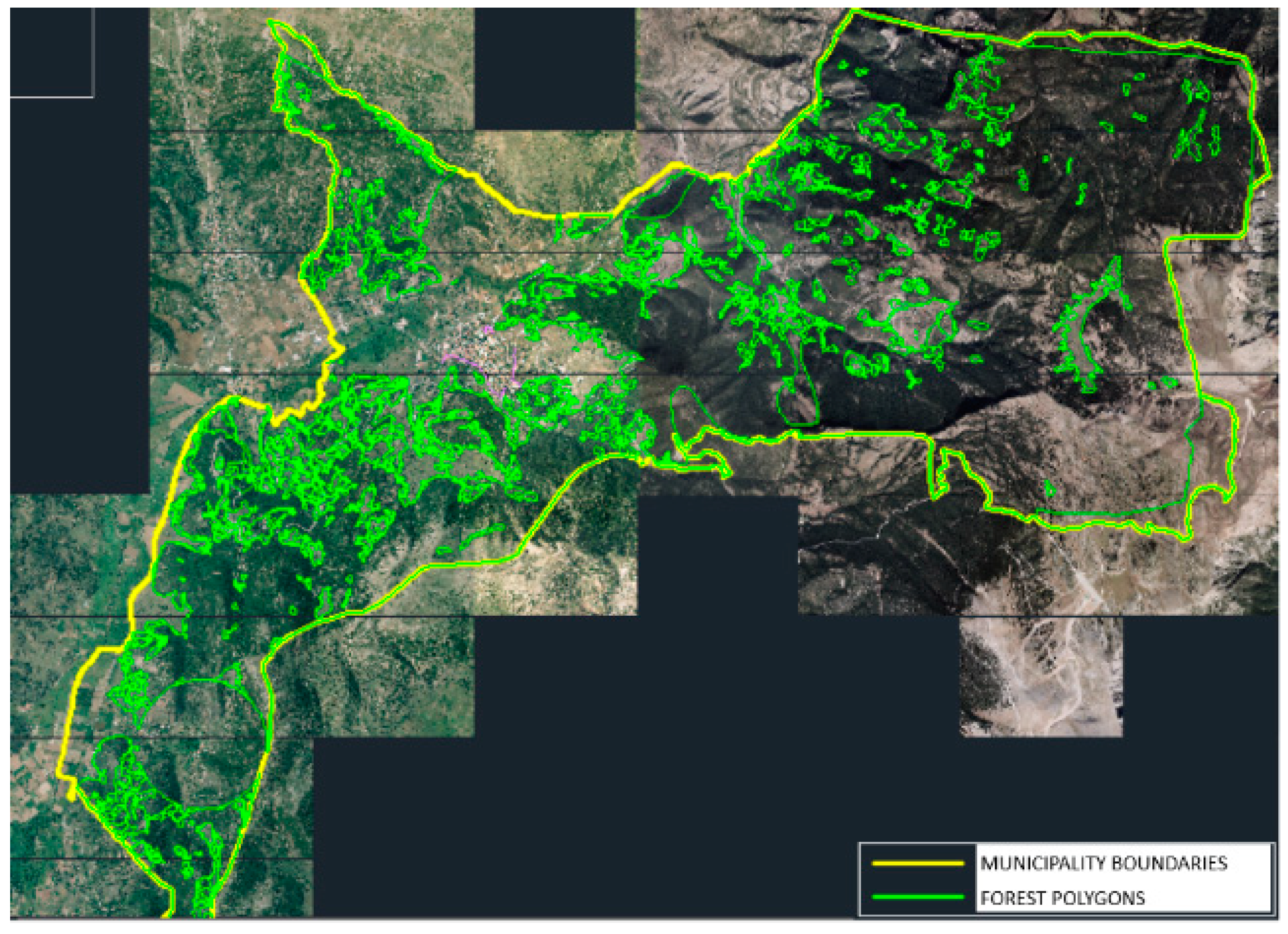
2.1.1. Delineation of All Administrative Boundaries in the Area under Cadastral Survey

In order to achieve the above goal, the contractor should process the provided data, collect any missing or necessary spatial data or administrative acts, define the boundaries of the urban areas and identify and delineate the land parcels on the orthophoto. In the case of missing information, the contractor should be able to conduct field surveys.
First, the contractor defines the boundaries of the cadastral study area as well as the boundaries of the urban settlements. The contractor derives this geospatial information from ELSTAT (Hellenic Statistical Authority) (Figure 2a). If needed (due to a reduced geometric accuracy of those data) the contractor adjusts them on the orthophoto with the man-made and the natural features such as rivers, road network, land parcel boundaries and the existing administrative acts (Figure 2b–d) in order to produce the edited boundaries of the cadastral study area (Figure 3).
Having defined the boundaries of the cadastral study area, the contractor delineates the boundaries of the urban settlements on the orthophoto. These boundaries are derived from the ratified city plans (Figure 4a). However, the contractor must also include the unplanned settlements (Figure 4b,c).
Next, the contractor should compile and submit the technical report with the edited boundaries in the Hellenic NMCA for technical checks and approval. Figure 5 shows the described procedure.

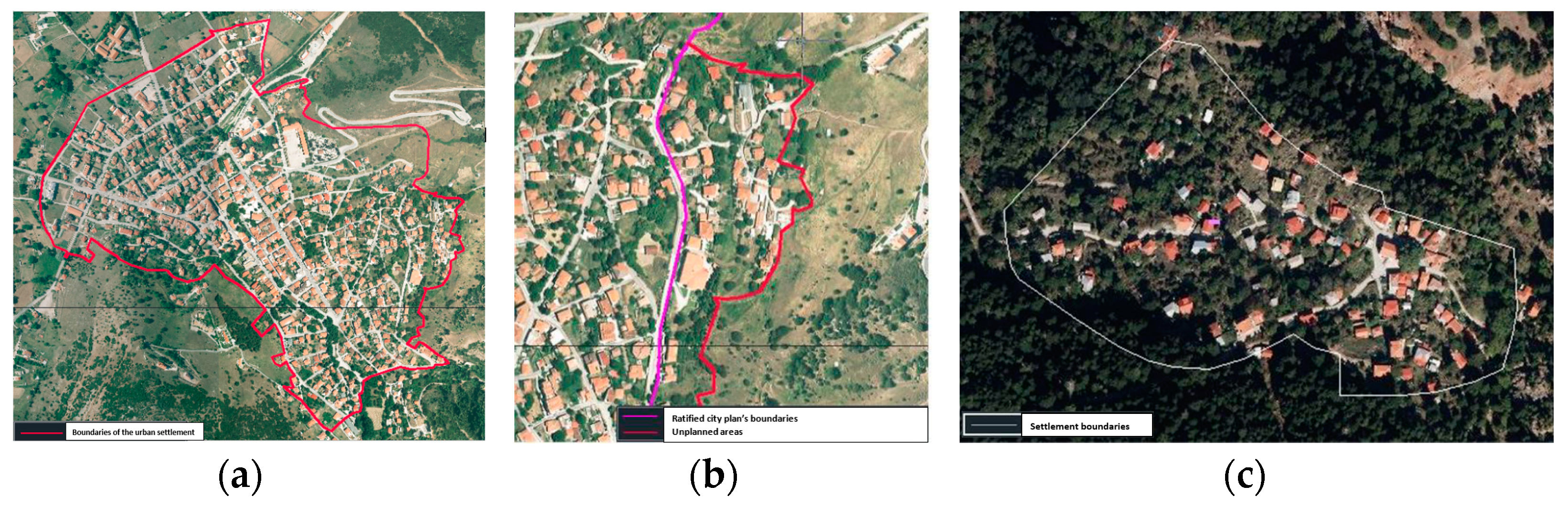
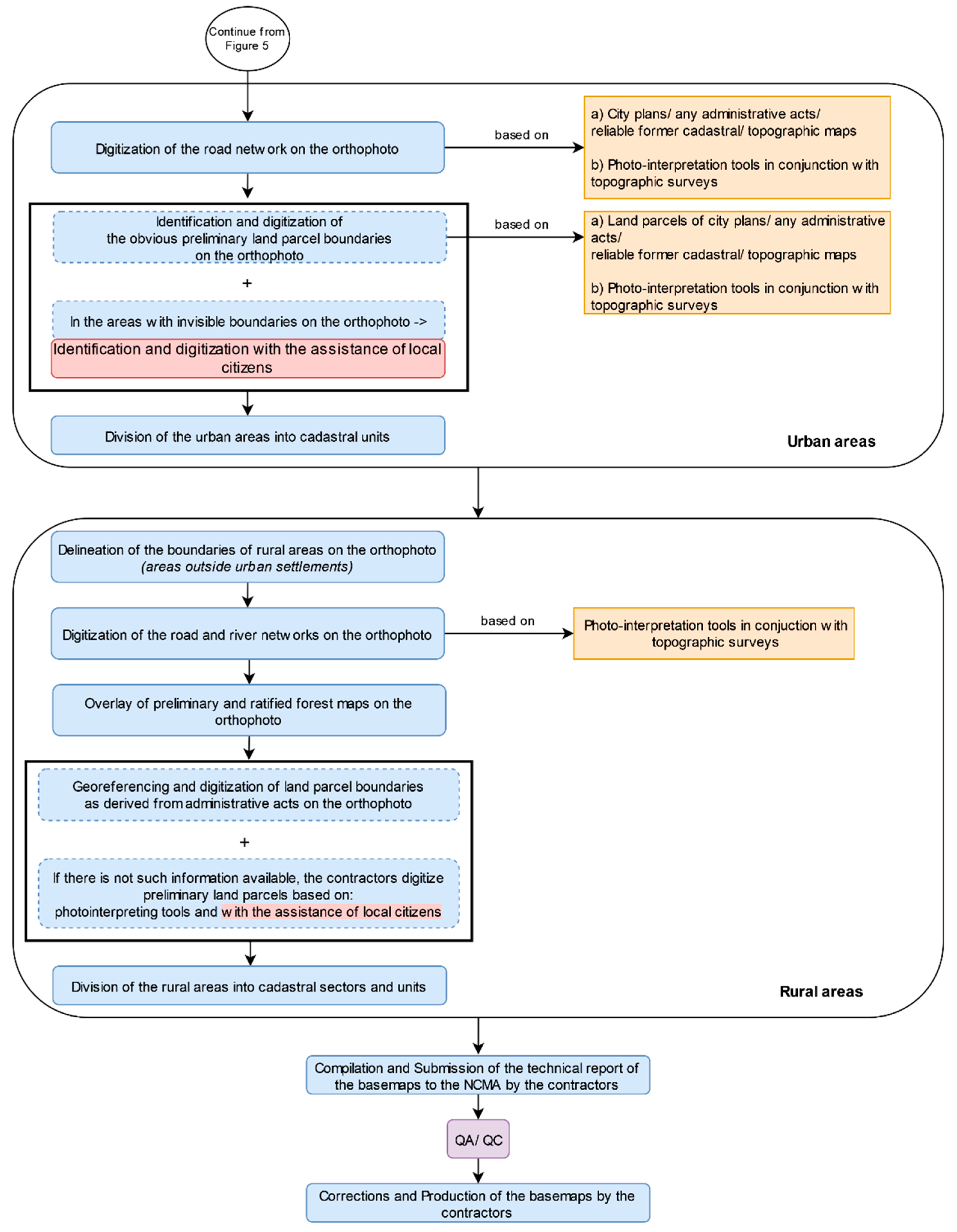
2.1.2. Compilation Procedure for the Advanced Basemap in Urban and Rural Areas

With the approval of the adjusted boundaries by NMCA, the contractor for the preparation of the advanced cadastral basemap for the urban areas must perform the following tasks:
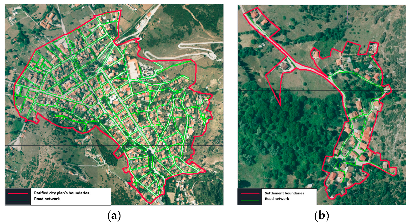
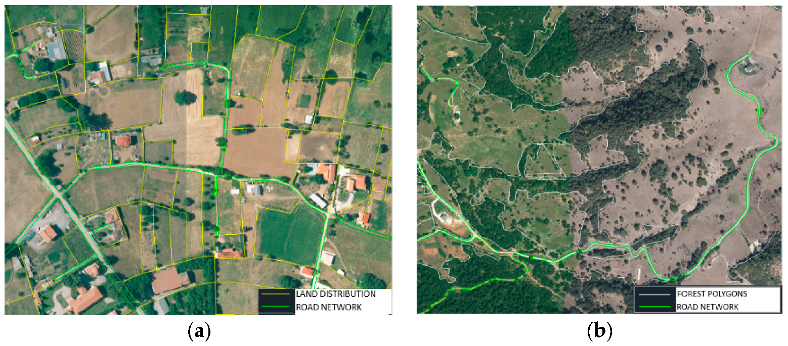
  • Digitize the road network based on the above-mentioned ratified city plans and/or any administrative acts and/or existing cadastral/topographic maps (prepared for particular projects in the past such as land expropriation, land consolidation, etc.) (Figure 6a). If there are no administrative acts in the area, the digitization of the road network should be conducted based on photo-interpretation tools in conjunction with topographic surveys (Figure 6b).
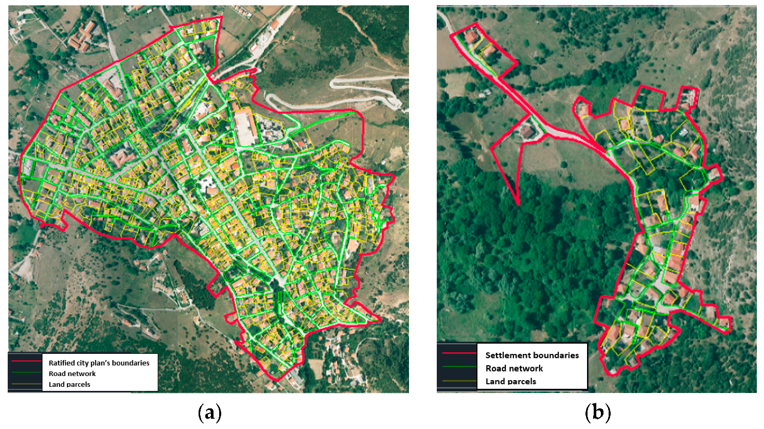
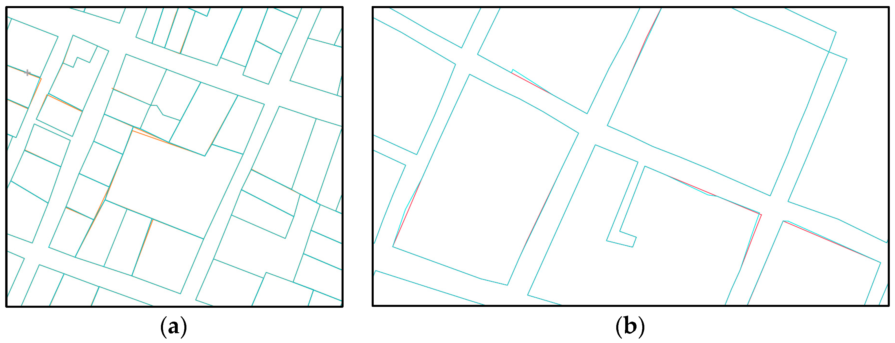
  • Identify and digitize the obvious preliminary land parcels on the orthophoto (Figure 7a,b). If land parcel boundaries are not visible on the orthophoto, the contractor should identify and digitize them with the assistance of local citizens. In this case, there should be cooperation with the local authorities for the mobilization and information of the local communities in order to achieve the maximum possible participation.
  • Divide the urban areas into cadastral units according to the following. In urban areas the cadastral units cover the area of a building block (excluding the surrounding streets), which are surrounded by roads, irrigation canals or other natural or man-made features. Each cadastral unit consists of a single polygon and takes a simple ascending numbering within each cadastral sector. Streets, public squares, parks and rivers take a separate code number. The cadastral numbers of specific cadastral areas such as the green areas or archaeological areas are defined in the special issue of Codification and Organization of the Hellenic Cadastre.
Figure 14 shows the above-described procedure.
In rural areas, the contractor for the preparation of the cadastral basemap must perform the following tasks (Figure 14):
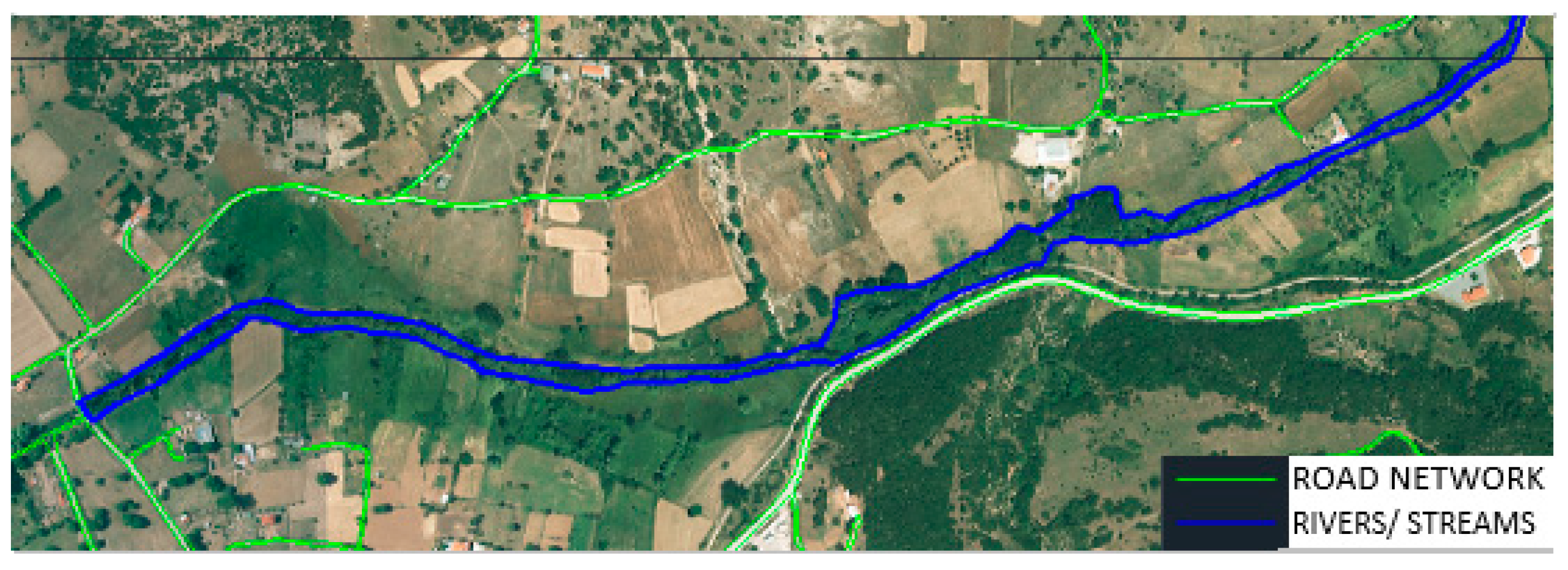
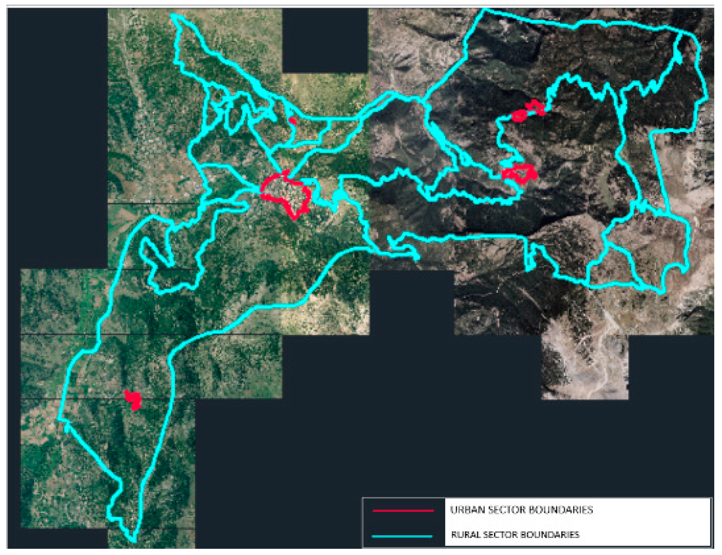
  • Definition and delineation of the boundaries of the rural areas under cadastral registration on the orthophoto (they are defined as the areas outside urban areas)
  • Digitization of the road and the river/stream networks on the orthophoto based on photo-interpretation tools in conjunction with topographic surveys (Figure 8, Figure 9 and Figure 10).
  • Overlay of the preliminary and ratified forest maps on the orthophoto (Figure 11).
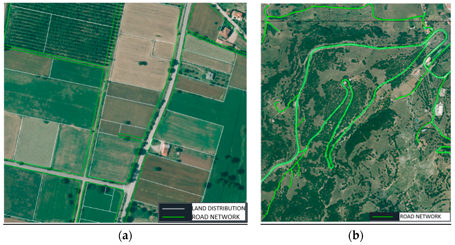
  • Geo-reference and digitization the land parcel boundaries as derived from existing administrative acts on the orthophoto. If there is not such information available, the contractor must digitize the preliminary land parcels based on photo-interpretation tools and with the assistance of local citizens (Figure 12a,b).
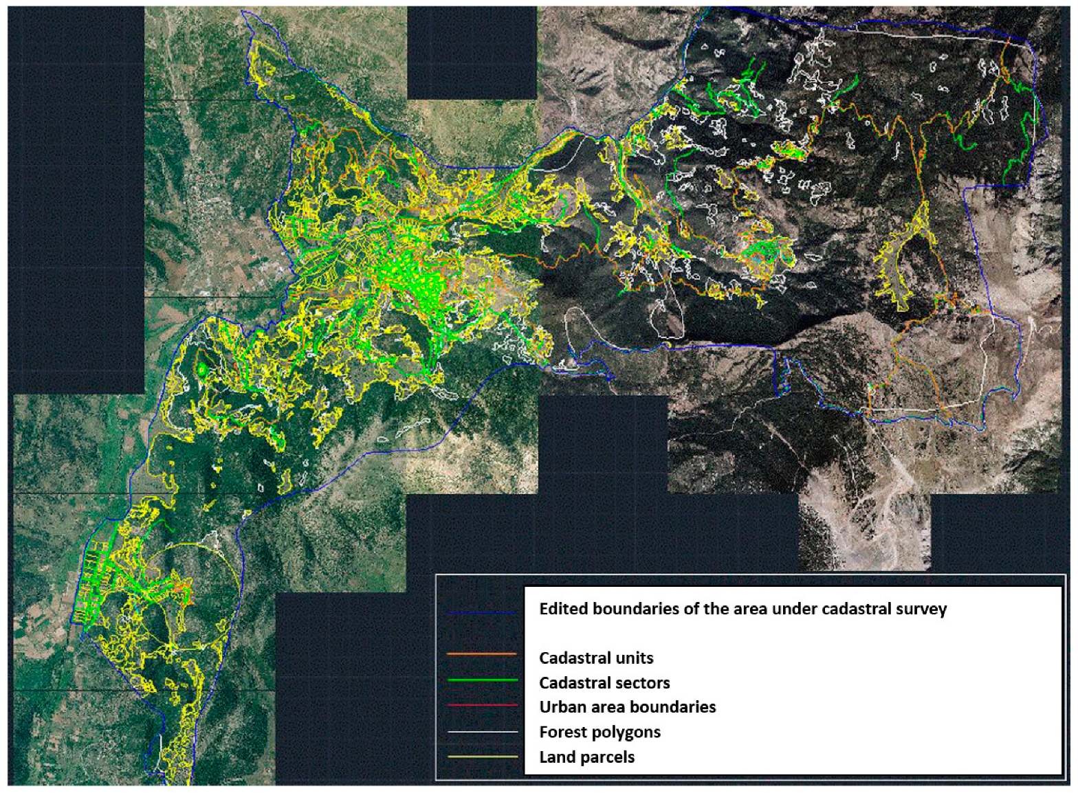
  • Divide the rural areas into cadastral units and cadastral sectors according to the following: The cadastral units cover, in the rural and other areas, an area of 20–200 hectares (or even more if this is deemed necessary), which is surrounded by roads, rivers or other natural or man-made features. Each cadastral unit consists of a single polygon and is coded with ascending numbering within each sector (as referred to in the special issue of the Codification and Organization of the Hellenic Cadastre) [34] (Figure 13).
Figure 14 shows an example of an advanced basemap.
Then, the contractor should compile and submit the technical report of the basemaps (for the urban and rural areas) in the NMCA for technical checks and approval (Figure 15).

2.1.3. Investigation of the Quality Assurance/Quality Control (QA/QC) Methodology Applied for the Hellenic Cadastral Project

As mentioned above, this section investigates the Quality assurance/Quality control (QA/QC) methodology applied for the Hellenic Cadastral Project to build awareness of the necessary controls that must be applied to assess the quality of the proposed crowdsourced cadastral basemap. A QA/QC methodology includes several controls related to compliance with the General Project Quality Program (equipment, staff, services, timetable, deliverables, etc.) and compliance of geospatial data with the technical specifications. However, in-depth research on how the quality of the intermediate and final deliverables is checked by the Hellenic Cadastre in detail, together with examples, justification of required accuracies and remaining challenges, is the objective of a future publication.
During the compilation process, as mentioned in [21], the contractors make QC assessment of their products (cadastral maps and data) before submitting these to the NMCA. The contractors make more than one submission of the cadastral maps and data to the NMCA, electronically, before proceeding to the next phase and receiving payments. In more detail, the intermediate and final submissions of the geospatial data (digital cadastral data) to the NMCA are:
(a)
submission of the preliminary cadastral database (advanced cadastral basemap),
(b)
submission of 50% of the digital cadastral database (following the declaration submission phase),
(c)
submission of the whole digital cadastral database (following the declaration submission phase),
(d)
Submission of the revised cadastral database (following the objection examination phase)
(e)
Submission of final cadastral database (following the initial registration).
Specifically, the intermediate deliverables referring to the compilation of the advanced cadastral basemap are:
  • Cadastral study area boundaries
    digital files of the boundaries
    technical report documenting the delineation of the boundaries
  • Compilation of the advanced preliminary cadastral basemap
    digital files of the advanced preliminary cadastral basemap
    metadata files, mk
    technical report
  • scanned documents and maps (legal and administrative documents referring to data received from existing relevant projects)
The deliverables of the following phases include the following:
  • the General Project Quality Program
  • the technical reports (compilation of the digital cadastral database and its revision, compilation of cadastral diagrams and tables)
  • digital database of descriptive cadastral data
  • digital database of spatial cadastral data
  • the quality index of cadastral base (sampling control)
  • geometric accuracy checking (sampling)
The Technical Specifications Regulation [34], provided by the NMCA, describes in detail the deliverables of the above submissions, as well as the necessary controls, to be made by the NMCA. In case the controls identify significant deviations, a revised new submission is required. As mentioned by [36], the QA/QC methodology applied for the Hellenic cadastral project includes the following:
  • Monitoring and controlling implementation of the Quality Plan
  • Auditing of Processes and Services provided by the Contractor
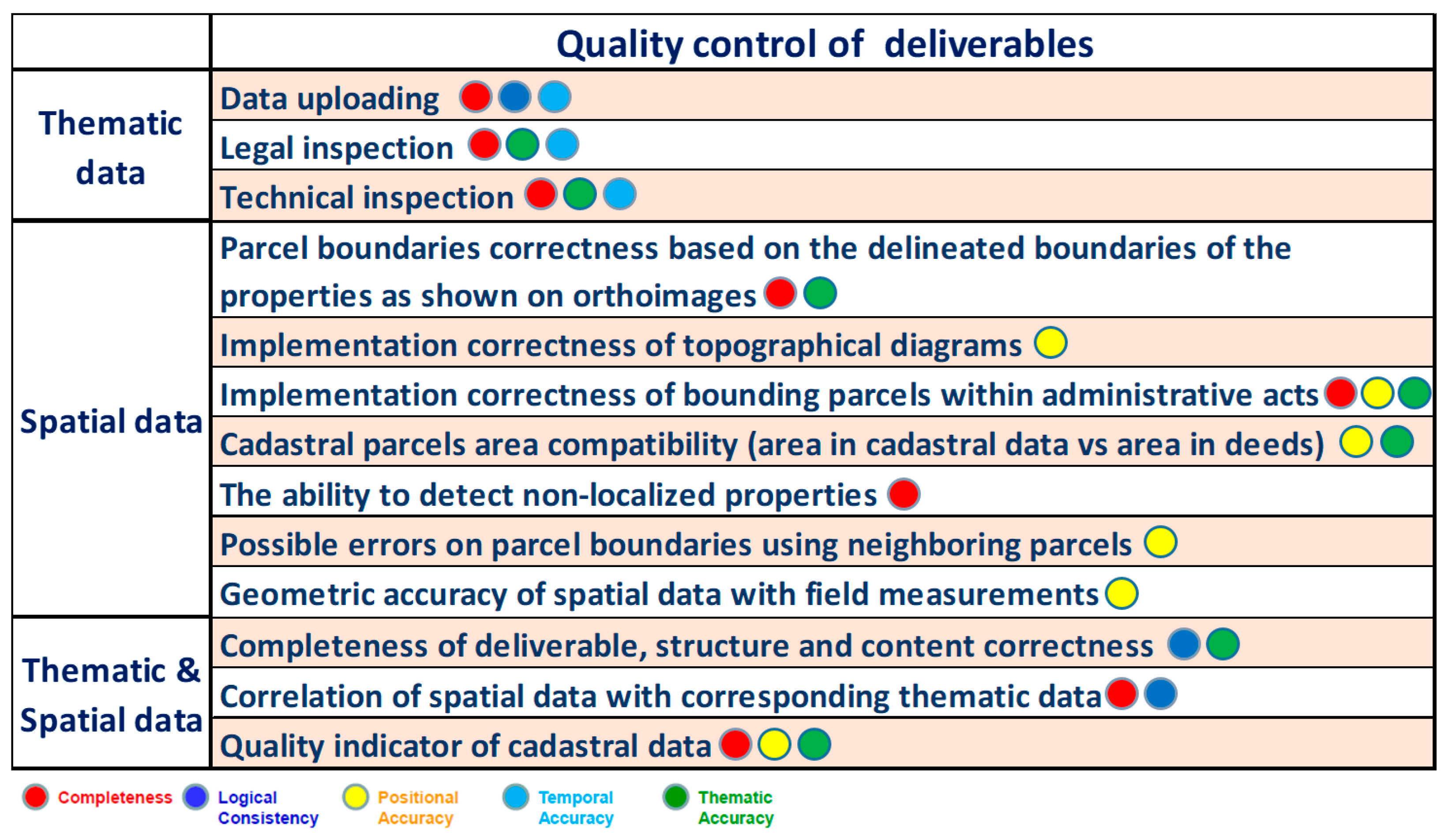
  • Quality control of cadastral project deliverables
The following issues determine the quality of the deliverables [36,37]:
  • Completeness of data, presence and absence of features, their attributes and their relations:
    Commission of data, redundancy and excesses in data (data do not contain necessary features and attributes);
    Omission of data, data absent from a dataset;
  • Logical consistency of data, degree of adherence to logical rules of data structure, attribution and relationships:
    Conceptual consistency, the internal coherence of the system’s structure and the nature of the mapping from user task goals to system procedures;
    Domain consistency, adherence of values to the value domains;
    Format consistency, degree to which data is stored in accordance with the physical structure of the dataset;
    Topological consistency, a set of rules that models the relationships between neighboring points, lines and polygons to determine how they share geometry;
  • Positional accuracy of data, accuracy of the position of features:
    Absolute accuracy, closeness of reported coordinate values to values accepted as or being true;
    Relative accuracy, closeness of the relative positions of features in a dataset to their respective relative positions accepted as or being true;
    Gridded data position accuracy, closeness of gridded data spatial position values to values accepted as or being true;
  • Temporal accuracy of data, the quality of temporal attributes and temporal relationship of features:
    Accuracy of a time measurement, closeness of reported time measurements to values accepted as or known to be true;
    Temporal consistency, ensures that the difference in the values, which is stored in the database of the real-time systems, and the real data is within some predefined limit;
    Temporal validity, enables tracking time periods of geospatial data for real world validity;
  • Thematic accuracy of data, measures the difference of attribute values from the true values:
    Classification correctness, the ratio of correctly classified objects with the total number of objects in the test set;
    Non-quantitative attribute accuracy, a measure of whether a non-quantitative attribute is correct or incorrect;
    Quantitative attribute correctness, closeness of the value of a quantitative attribute to a value accepted as or known to be true.
Two types of controls take place: controls of intermediate deliverables and controls of final deliverables. Figure 16 shows in detail the adopted QC methodology of intermediate and final deliverables. Thematic data are checked in terms of completeness, logical consistency, temporal accuracy and thematic accuracy (such as id data, addresses, land registry numbering, deed data, etc.). Spatial data are checked in terms of completeness, positional accuracy and thematic accuracy (such as geometric accuracy of boundary nodes, compatibility of land parcel area size on the cadastral map and on the deed, etc.).
It is important to mention that the effectiveness of the adopted intermediate QC methodology has resulted in significantly smaller numbers of appeals and petitions for correction by the right holders during the objections submission phase (average 3.4% & <1.5% in spatial data).
Controls refer, by example, to the:
  • compliance with the required accuracy,
  • geo-reference of the administrative acts,
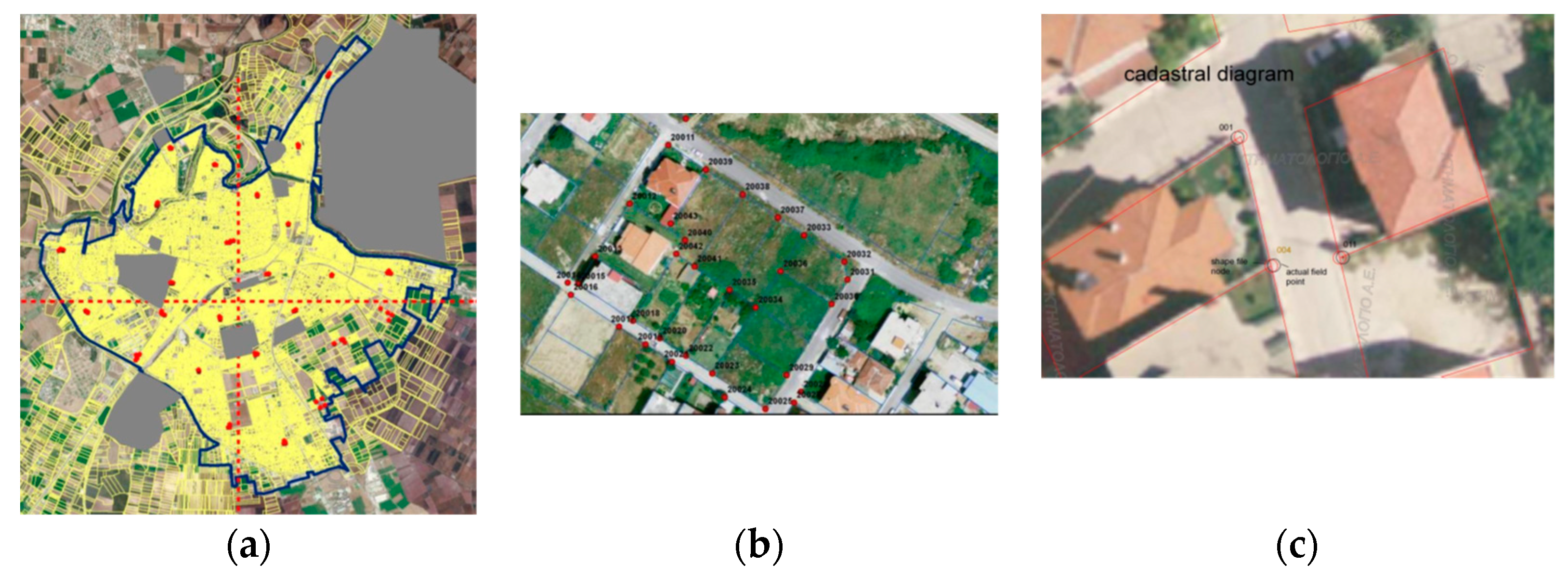
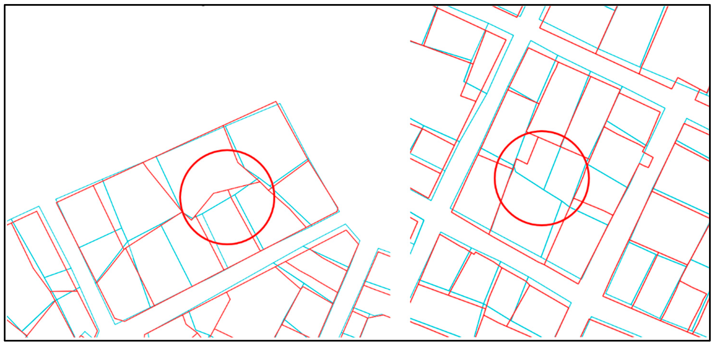
  • completeness regarding titles, right holder data, land parcel area size, etc. (Figure 17a,b)
  • field measurements to test compatibility with HEPOS
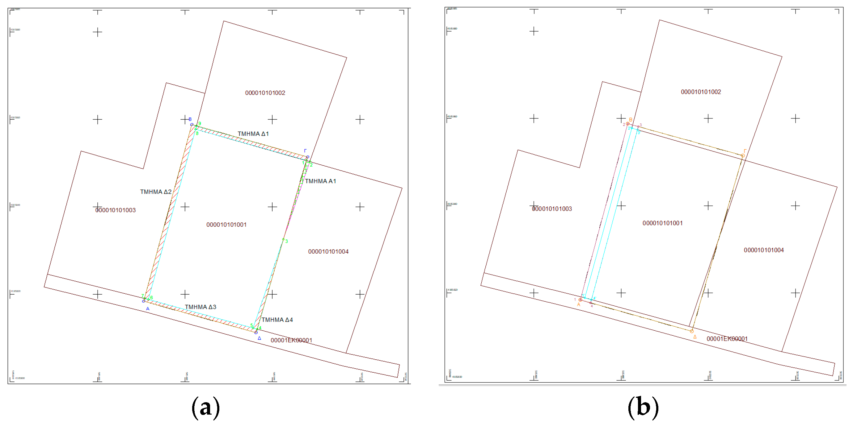
  • field measurements to test adjustment of administrative acts (Figure 18a,b)
  • field measurements and field inspections to check the boundaries of the land parcels (Figure 18a–c)
  • cadastral basemap completeness regarding required accuracies and scales

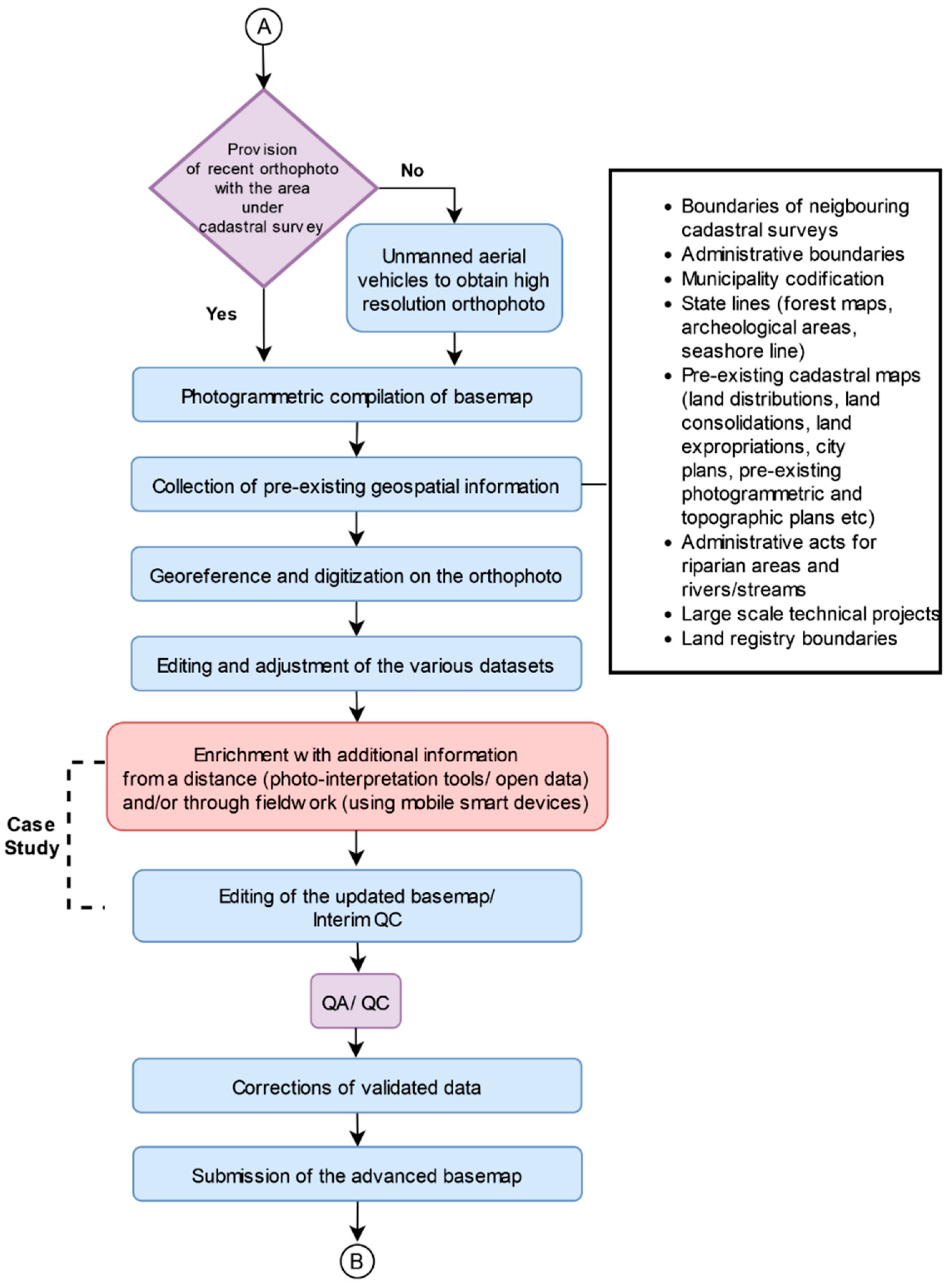
2.2. Proposed Model for the Compilation of an Advanced Crowdsourced Basemap

To improve the quality of the crowdsourced cadastral surveys, the first and most important step is the compilation and use of an advanced basemap. For this, the authors suggest that trained volunteers may be involved following training provided by the professional surveyor/contractor.
A compilation model for an advanced basemap for crowdsourced cadastral surveys based on the above investigation is proposed. To produce the advanced crowdsourced basemap, additional geospatial information should be overlayed on recent orthophotos (Very Large Scale Orthophotos—VLSOs and Large Scale Orthophotos—LSOs), as shown in Figure 19. In the proposed model, the professionals responsible for the crowdsourced cadastral survey should undertake part of the task they perform for the Hellenic Cadastre (e.g., the geo-reference, the adjustment and the editing of the pre-existing geospatial data) and will guide a team of trained volunteers to undertake any further enrichment.
Further enrichment may include, for example, missing road or river network information, names of roads and rivers; forest areas; rural settlements, formal or informal, lacking city plans (e.g., land parcels, roads, settlement names, public spaces, settlement boundaries); building footprints (e.g., formal or informal constructions); green areas; points of interest (stadiums, hospitals, municipal buildings, etc.). The volunteers may collect such data from a distance (photo-interpretation tools/open data) and/or through fieldwork (using mobile smart devices). The compilation of an advanced basemap requires a long-term commitment by the volunteers and specific skills. Therefore, the number of volunteers used for this specific task should be small, while for the declaration submission phase, as mentioned above (introduction of Section 2), this number is large [22,39].
Professionals should undertake the editing of the updated basemap produced by the volunteers and then the NMCA should validate the updated basemap before making it available for for the people to proceed with the declaration submission.
To achieve an AAA crowdsourced cadastre there is a need to continuously improve the accuracy of the data (thematic and geospatial). For that purpose, further improvement of the quality of the crowdsourced cadastral surveys requires a General Project Quality Program. Therefore, the authors suggest an updated version of model [21]. This updated model includes a General Project Quality Program (equipment, staff, services, timetable, deliverables, etc.) and compliance of geospatial data with the AAA technical specifications. Through this model, a gradual upgrade of the FFP crowdsourced cadastral survey will develop into an AAA cadastre.
This model includes the proposed QA/QC steps for the compilation of a crowdsourced cadastral survey that aims to develop an AAA cadastre. Specifically, the proposed updated model includes three QA/QCs, as shown in Figure 20 in bright green:
  • First QA/QC takes place following the compilation of the advanced basemap
  • Second QA/QC takes place following the declaration submission phase
  • Third QA/QC takes place following the objection’s submission phase.
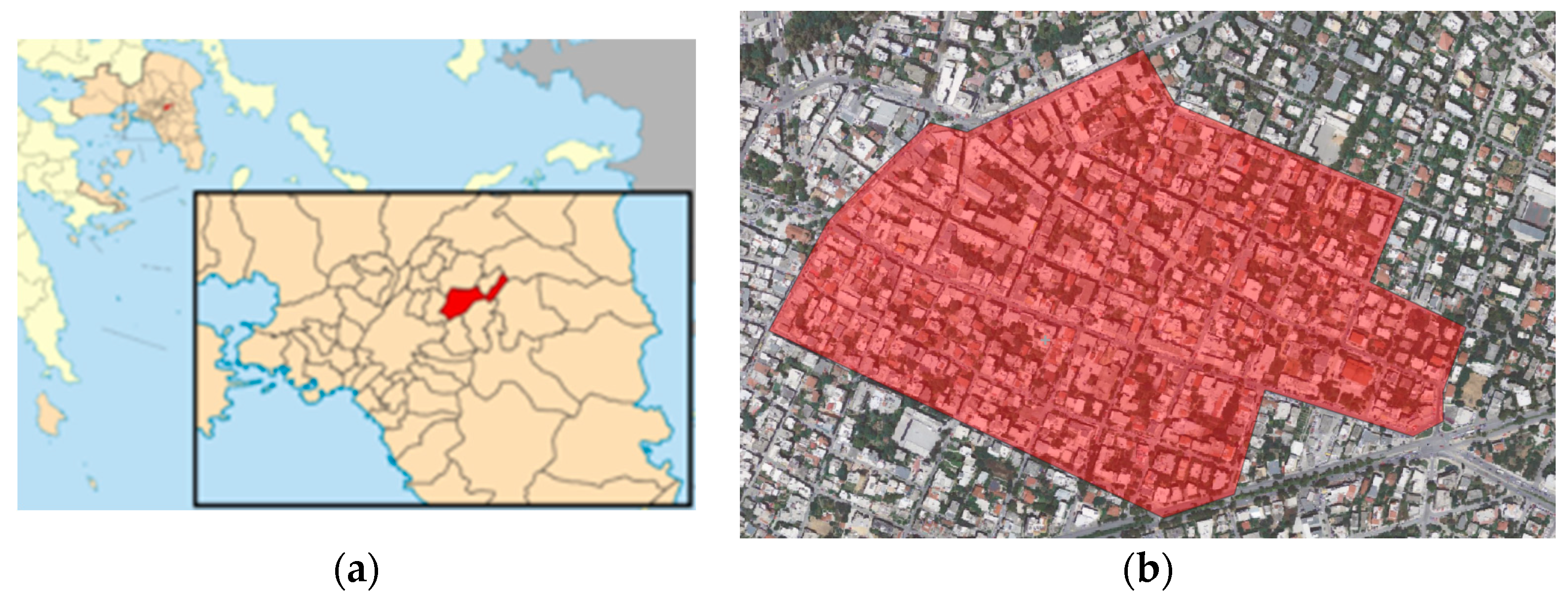
Future research will provide in detail a methodology for the QA/QC implementation. The improved model [21] will then be further updated.

3. Case Study

To test the proposed methodology for the compilation of a crowdsourced advanced basemap, a case study is given. A neighborhood of the Chalandri municipality (Attika region, Greece) (Figure 21) is selected, because an official cadastral survey for that urban area is available and can be used to compare the results. In addition, the structure of an urban area is much more complicated than a rural area. The area size of the study is about 0.26 km2 (46 blocks) (Figure 21).
The objective of this case study is to test the proposed methodology in terms of geometric accuracy, completeness and duration and to investigate the potential of the team of trained volunteers to participate in such projects in the future. It focuses on the stage where the trained volunteers participate in the updating of the basemap, as shown in Figure 19, ‘marked as case study’.

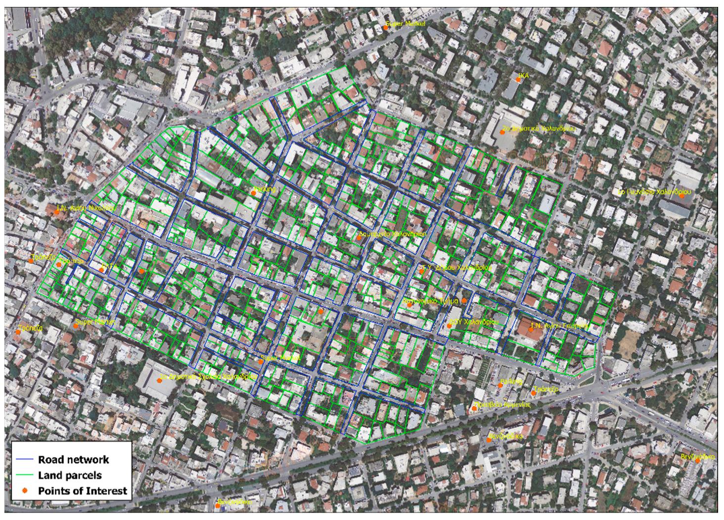
3.1. Data Collection by a Team of Trained Volunteers

As mentioned at the beginning of Section 2.2, for this task a committed small group of young (keener in the use of digital applications) and trained volunteers is needed [22]. Following a one-hour training course provided by the cadastral surveyor, 11 volunteers undertake the collection of geospatial information using the ESRI’s ArcGIS Collector application for data collection, in conjunction with ESRI’s ArcGIS online [5].
The original basemap is the NMCA orthophoto of 2007 (open data) that is georeferenced using ESRI’s ArcGIS software based on the Greek Geodetic Reference System (GGRS’87).
Motivation for further commitment for voluntary participation, such as certificates of acknowledgement, is also provided. Data collection is made from a distance (land parcel boundaries, points of interest and road network) (Figure 22).
The volunteers digitize 571 land parcels, as well as the road network within the building blocks. Twenty-nine more points of interest, such as public buildings, gas stations, supermarkets and banks, are digitized. To calculate the working hours required to complete this task, the data collection and mapping duration is timed. Data collection duration is one day.

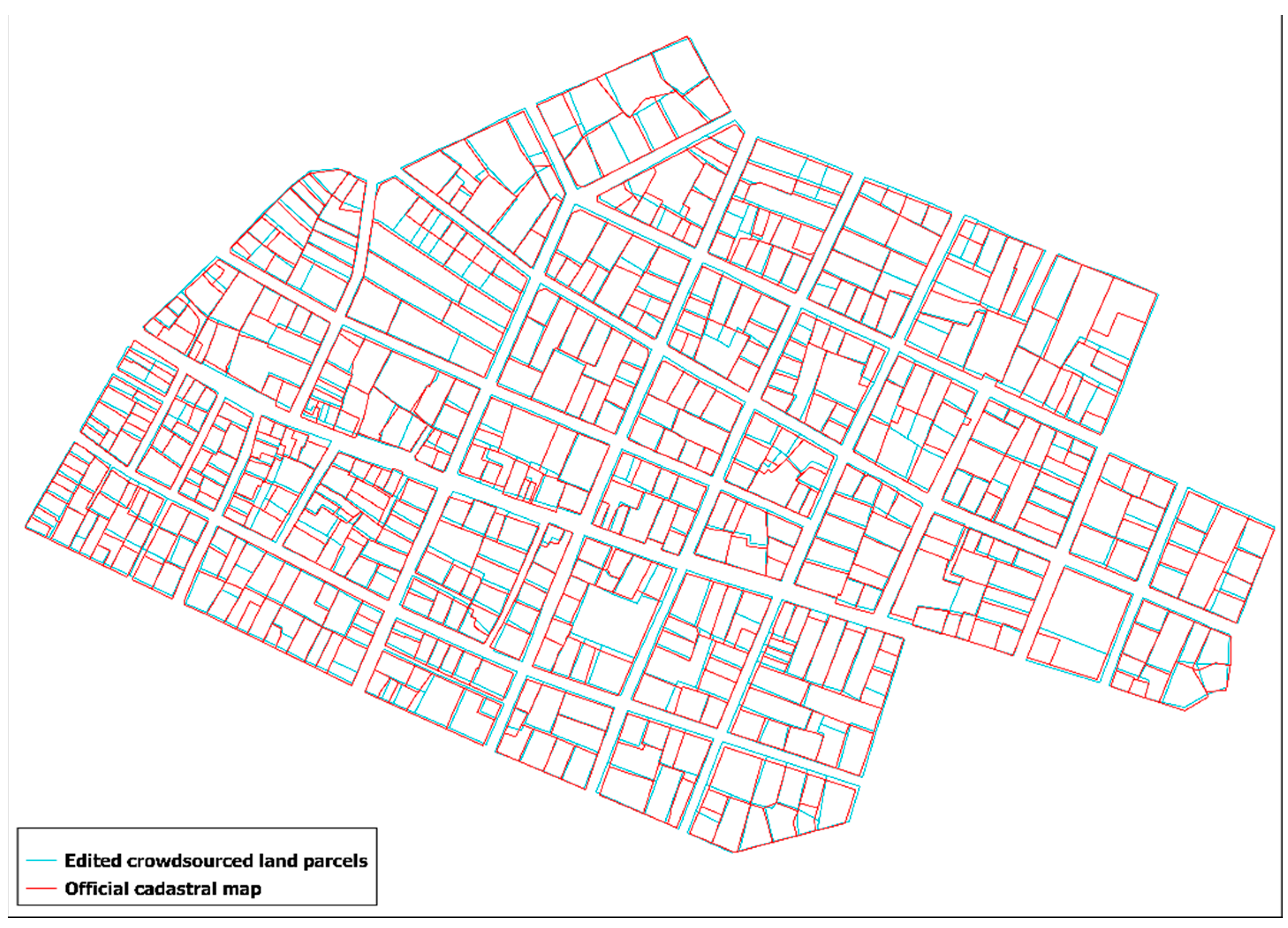
3.2. QC and Editing by a Cadastral Surveyor

Part (a) of Figure 23 shows the land parcels as digitized by the volunteers in green and the editing as provided by the professional (in terms of completeness, geometric accuracy and snaps of lines) in orange. Part (b) shows the road network as digitized by the volunteers in light blue and the editing conducted by the professional in terms of completeness, geometric accuracy and snaps of lines) in red.
To assess the achieved accuracies a comparison with the official cadastral map is made; deviations from the crowdsourced cadastral basemap are detected. For the QC the Hellenic Cadastre specifications are used.
Required geometric accuracies (applicable nationwide in all landscapes in Greece) are: RMSx = ±0.5 m; RMSy = ±0.5 m; and RMSxy = ±0.71 m (urban areas) and RMSx = ±1.0 m; RMSy = ±1.0 m; and RMSxy = ±1.41 m (rural areas). Absolute accuracy = ±0.98 m (for a confidence level of 95%).
The geometric positional accuracy of the crowdsourced nodes is tested based on the methodology applied by the Hellenic Cadastre [40].
In detail, the coordinates of the crowdsourced cadastral data are compared with the coordinates of the official cadastral data to calculate the relevant statistical deviations that determine the level of accuracy of the crowdsourced cadastral data.
For the optimal distribution of the sample, a polygon orthogonalization that defines the study area is required, which will be done by optimally fitting a rectangular shape to the study area. In the resulting rectangular shape, at least 20% of the control points (CPs) should be distributed within each quadrant. The density between the CPs should correspond approximately to 1/10 of the length of the diagonal line of the rectangular (Figure 24). This method is followed by the Hellenic Cadastre QC, based on ISO 2859-2:1985 [40,41].
The sample size depends on the size of the area. For urban areas (scale: 1/1000) is:
Number of CPs = [(Area in hectares × 0.1)/12,000] × 20 points.
The professional removes all obvious errors prior to the calculation of the geometric compatibility and deviations. The land parcels that have been segmented or unified or have been presented differently and in ‘’odd’’ way in the official maps are identified as obvious errors (marked in red circle in Figure 25). Such errors can only be clarified during the declaration submission phase.
The geometric compatibility of the area size of a parcel is calculated as following: ΔE = |E−EΔ| < EA, where E is the measured value, EΔ is the area value as written in the deed, or in a pre-existing survey. EA = Π, where Π is the perimeter of the parcel and 0.2 m ≤ α ≤ 0.3m (for urban areas) and 0.95 m ≤ α ≤ 1.50 m (for rural areas). Based on this, the achieved accuracy in 79 out of 571 (14% of the total) land parcels is not accepted. Figure 26 shows the comparison between these two datasets. Average accuracy deviation is 0.58 m, maximum deviation is 1.77 m, which are accepted.
Figure 27 shows the edited advanced crowdsourced cadastral basemap. Editing duration is 3 h.

4. Discussion/Conclusions

Past research [5,14,17,21,22] shows that using an orthophoto as a basemap, smart devices and appropriate software [31] can provide a reliable tool for the compilation of cadastral surveys, either in the field or from a distance, that can satisfy technical specifications for an AAA cadastre. The achievement of the maximum possible geometric accuracy totally depends on the capacity of the user. In crowdsourced cadastral surveys, the user is a non-professional. A short-term training course increases the capacity of the involved non-professionals and reduces errors in the process.
Non-professionals involved in the proposed methodology are usually the right holders or local residents that know the area and the history of tenure. A large number of non-professionals is involved in the process but only for: (a) a specific task and (b) a relatively short time of commitment [22].
To avoid gross location errors and improve the efficiency of non-professionals in identifying the right parcel location on the basemap, the proposed methodology introduces the compilation of an advanced basemap enriched with more information such as road, settlement and river names, green areas, points of interest, urban blocks, road and river network, obvious land parcel boundaries, building footprints, etc. That will make the location process for non-professionals even easier. A team of trained volunteers may undertake this task. Such a task requires longer commitment and training of a small group of volunteers. This stage will satisfy a FFP approach [22].
In addition, the proposed methodology suggests enriching the basemap with all relevant pre-existing geospatial information derived from officially ratified projects, to avoid possible errors in the declaration submission phase and to increase quality of the final product.
Depending on the availability of funds and the particular situation of each project, this current research introduces intermediate and final QA/QC produced either by a professional and/or by the NMCA. Research on the compilation procedure of the Hellenic cadastral project given in this paper has proved that intermediate QA/QC are crucial for the final accuracy of the cadastral survey.
A more detailed assessment of the methodology based on the case study refers to the completeness of information, achieved geometric accuracy and duration.
Regarding completeness of information: the use of more recent orthophotos, if available, would have increased completeness. In areas where information may be invisible (such as boundaries hidden by trees) recording is approximate. If recent orthophotos are provided and/or field visits can be made in parallel, such weaknesses will be avoided.
Regarding geometric accuracy, minor problems appear regarding the shape of the various parcel polygons. Complex parcel polygons, as well as parcels with invisible parts concealed by a tree canopy, appeared differently on the official maps.
Regarding the capacity of volunteers, in the distinction between land parcel boundaries and the road network, small deviations appear. Non-professionals’ perception of land parcel boundaries is usually not sufficient. As specific people gain experience through longer commitment in the project, this will be improved.
Regarding costs and times, recording of 0.26 km2 is completed in six working-hours. Each volunteer records about 22.000 m2. The professional completes the editing process of the total product in about 3 h. For the whole Chalandri municipality (10.8 km2), 240 man-hours (approximately 28 days for the team of 11 volunteers) are needed. Editing requires 100 man-hours. This includes the:
  • Data Completion (polygon, point-data),
  • Geometric accuracy corrections,
  • Required man-hours for decisions,
  • Preparation of the e-course and the training of volunteers (about eight man-hours).
The introduction of crowdsourcing reduces the required costs significantly and the proposed methodology for compilation of advanced cadastral basemaps successfully meet the objectives of the research. The case study cannot provide an estimation of the cost reduction. However, as mentioned by [24], the FFP methodology reduced the budget of “Terra Segura” project in Mozambique (a program to regularize five million parcels and delimitate 4000 communities in a period of 5 years) by 30%, just by optimizing and combining resources and activities.
Follow up of this paper includes the modelling of cadastral data maintenance and updating procedure using crowdsourced methodology. This is of great value, especially for the maintenance and updating of urban areas where changes in the use of land are not recorded systematically.

Author Contributions

Conceptualization, C.P. and K.A.; methodology, C.P. and K.A.; software, C.P. and K.A.; validation, C.P. and K.A.; formal analysis, C.P. and K.A.; investigation, C.P. and K.A.; resources, C.P. and K.A.; data curation, C.P. and K.A.; writing—original draft preparation, C.P. and K.A.; writing—review and editing, C.P. and K.A.; visualization, C.P. and K.A.; supervision, C.P.; project administration, C.P. All authors have read and agreed to the published version of the manuscript.

Funding

This research received no external funding.

Institutional Review Board Statement

Not applicable

Informed Consent Statement

Not applicable

Data Availability Statement

Not applicable.

Acknowledgments

The contribution of Konstantinos Apostolopoulos to this research is part of his Ph.D. dissertation, which is supported by the Eugenides Foundation scholarship program.

Conflicts of Interest

The authors declare no conflict of interest.

References

  1. Jones, B.; Lemmen, C.; Molendijk, M.; Gorton, K. Fit-for-Purpose and Fit-for-Future Technology for Cadastral Systems. In Proceedings of the World Bank Conference on Land and Poverty, Washington, DC, USA, 24–27 March 2014. [Google Scholar]
  2. Basiouka, S.; Potsiou, C. VGI in Cadastre: A Greek Experiment to Investigate the Potential of Crowdsourcing Techniques in Cadastral Mapping. Surv. Rev. 2012, 44, 153–161. [Google Scholar] [CrossRef]
  3. Basiouka, S.; Potsiou, C. Improving Cadastral Survey Procedures using Crowdsourcing Techniques. mCoord. Mag. 2012, 8, 20–26. [Google Scholar]
  4. Molendijk, M.; Dukon, T.S.; Lemmen, C.; Morales, J.; Endo, V.; Rodriguez, S.R.; Dueñas, J.F.G.; Sanchez, I.E.M.; Spijkers, P.; Unger, E.M.; et al. Land and Peace in Colombia: FFP Methodology for Field Data Collection and Data Handling. In Proceedings of the World Bank Conference on Land and Poverty, Washington, DC, USA, 19–23 March 2018. [Google Scholar]
  5. Mourafetis, G.; Apostolopoulos, K.; Potsiou, C.; Ioannidis, C. Enhancing Cadastral Surveys by Facilitating the Participation of Owners. Surv. Rev. 2015, 47, 316–324. [Google Scholar] [CrossRef]
  6. Enemark, S.; Mclaren, R.; Lemmen, C. Building fit-for-purpose land administration systems. In Proceedings of the XXV FIG congress, Kuala Lumpur, Malaysia, 16–21 June 2014; Available online: http://www.fig.net/resources/proceedings/figproceedings/fig2014/papers/SS10/SS10enemarklemmen_et_al_7210.pdf (accessed on 20 June 2022).
  7. Enemark, S.; McLaren, R.; Lemmen, C.H.J. Fit-for-Purpose Land Administration: Guiding Principles for Country Implementation: E-Book; United Nations Human Settlements Programme (UN-HABITAT): Nairobi, Kenya, 2016. [Google Scholar]
  8. Navratil, G.; Frank, A. VGI for land administration—A quality perspective. In Proceedings of the 8th International Symposium on Spatial Data Quality, Hong Kong, China, 30 May–1 June 2013. [Google Scholar]
  9. Arsanjani, J.J.; Barron, C.; Bakillah, M.; Helbich, M. Assessing the Quality of OpenStreetMap Contributors together with their Contributions. In Proceedings of the AGILE, Leuven, Belgium, 14–17 May 2013; pp. 14–17. [Google Scholar]
  10. Helbich, M.; Amelunxen, C.; Neis, P.; Zipf, A. Comparative Spatial Analysis of Positional Accuracy of OpenStreetMap and Proprietary Geodata. Proc. GI_Forum 2012, 4, 24. [Google Scholar]
  11. Kalantari, M.; La, V. Assessing OpenStreetMap as an Open Property Map. In OpenStreetMap in GIScience; Arsanjani, J.J., Zipf, A., Mooney, P., Helbich, M., Eds.; Springer: Cham, Switzerland, 2015; pp. 255–272. [Google Scholar]
  12. Moreri, K.; Fairbairn, D.; James, P. Technological solutions for citizens’ participation into cadastral mapping. In Proceedings of the 27th International Cartographic Conference 16th General Assembly—Maps Connecting the World, Rio de Janeiro, Brazil, 23–28 August 2015. [Google Scholar]
  13. Basiouka, S.; Potsiou, C. A Proposed Crowdsourcing Cadastral Model: Taking Advantage of Previous Experience and Innovative Techniques. In European Handbook of Crowdsourced Geographic Information; Capineri, C., Haklay, M., Huang, H., Antoniou, V., Kettunen, J., Ostermann, F.O., Purves, R.S., Eds.; Ubiquity Press: London, UK, 2016; pp. 419–433. [Google Scholar]
  14. Gkeli, M.; Apostolopoulos, K.; Mourafetis, G.; Ioannidis, C.; Potsiou, C. Crowdsourcing and Mobile Services for a Fit-for-purpose Cadastre in Greece. In Proceedings of the 4th International Conference on Remote Sensing and Geoinformation of the Environment (RSCy2016), Paphos, Cyprus, 4–8 April 2016. [Google Scholar]
  15. Basiouka, S.; Potsiou Cand Bakogiannis, E. OpenStreetMap for Cadastral Purposes: An Application Using VGI for Official Processes in Urban Areas. Surv. Rev. 2015, 47, 333–341. [Google Scholar]
  16. Rahmatizadeh, S.; Rajabifard, A.; Kalantari, M. A conceptual framework for utilising VGI in land administration. Land Use Policy 2016, 56, 81–89. [Google Scholar] [CrossRef]
  17. Apostolopoulos, K.; Geli, M.; Petrelli, P.; Potsiou, C.; Ioannidis, C. A New Model for Cadastral Surveying Using Crowdsourcing. Surv. Rev. 2018, 50, 122–133. [Google Scholar] [CrossRef]
  18. Moreri, K.K.; Fairbairn, D.; James, P. Issues in developing a fit for purpose system for incorporating VGI in land administration in Botswana. Land Use Policy 2018, 77, 402–411. [Google Scholar]
  19. Moreri, K.K.; Fairbairn, D.; James, P. Volunteered Geographic Information Quality. Int. J. Geogr. Inf. Sci. 2018, 32, 931–959. [Google Scholar] [CrossRef]
  20. Asiama, K.; Bennett, R.; Zevenbergen, J. Participatory Land Administration on Customary Lands: A Practical VGI Experiment in Nanton, Ghana. Int. J. Geoinfor. 2017, 6, 186. [Google Scholar] [CrossRef]
  21. Potsiou, C.; Paunescu, C.; Ioannidis, C.; Apostolopoulos, K.; Nache, F. Reliable 2D Crowdsourced Cadastral Surveys: Case Studies from Greece and Romania. ISPRS Int. J. Geo-Inf. 2020, 9, 89. [Google Scholar] [CrossRef]
  22. Cetl, V.; Ioannidis, C.; Dalyot, S.; Doytsher, Y.; Felus, Y.; Haklay, M.; Mueller, H.; Potsiou, C.; Rispoli, E.; Siriba, D. New Trends in Geospatial Information: The Land Surveyors Role in the Era of Crowdsourcing and VGI; FIG PUBLICATION NO. 73; International Federation of Surveyors (FIG): Copenhagen, Denmark, 2019; ISSN 2311-8423. [Google Scholar]
  23. García-Morán, A.; Ulvund, S.; Unger, E.-M.; Bennett, R.M. Exploring PPPs in Support of Fit-for-Purpose Land Administration: A Case Study from Côte d’Ivoire. Land 2021, 10, 892. [Google Scholar] [CrossRef]
  24. Balas, M.; Carrilho, J.; Lemmen, C. The Fit for Purpose Land Administration Approach-Connecting People, Processes and Tech-nology in Mozambique. Land 2021, 10, 818. [Google Scholar] [CrossRef]
  25. Kelm, K.; Antos, S.; McLaren, R. Applying the FFP Approach to Wider Land Management Functions. Land 2021, 10, 723. [Google Scholar] [CrossRef]
  26. Williams-Wynn, C. Applying the Fit-for-Purpose Land Administration Concept to South Africa. Land 2021, 10, 602. [Google Scholar] [CrossRef]
  27. Potsiou, C.; Ioannidis, C. Why Crowdsourcing in Surveying. In Proceedings of the FIG Working Week 2019, Hanoi, Vietnam, 22–26 April 2019; Available online: https://www.fig.net/resources/proceedings/fig_proceedings/fig2019/papers/ts04c/TS04C_potsiou_ioannidis_10191_abs.pdf (accessed on 24 March 2020).
  28. Bakogiannis, E.; Potsiou, C.; Apostolopoulos, K.; Kyriakidis, C. Crowdsourced Geospatial Infrastructure for Coastal Management and Planning for Emerging Post COVID-19 Tourism Demand. Tour. Hosp. 2021, 2, 261–276. [Google Scholar] [CrossRef]
  29. Rocha, L.A.; Montoya, J.; Ortiz, A. Quality Assurance for Spatial Data Collected in Fit-for-Purpose Land Administration Approaches in Colombia. Land 2021, 10, 496. [Google Scholar] [CrossRef]
  30. Williamson, I.P.; Rajabifard, A.; Kalantari, M.; Wallace, J. AAA Land Information: Accurate, Assured and Authoritive. In Proceedings of the 8th FIG Regional Conference 2012 Surveying Towards Sustainable Development, Montevideo, Uruguay, 26–29 November 2012. [Google Scholar]
  31. Apostolopoulos, K.; Potsiou, C. Consideration on how to introduce Gamification tools to enhance Citizen Engagement in Crowdsourced Cadastral Surveys. Surv. Rev. 2021, 54, 142–152. [Google Scholar] [CrossRef]
  32. Balla, E.; Zevenbergen, J.; Madureira, A.M.; Georgiadou, Y. Too Much, Too Soon? The Changes in Greece’s Land Administration Organizations during the Economic Crisis Period 2009 to 2018. Land 2022, 11, 1564. [Google Scholar] [CrossRef]
  33. Mourafetis, G.; Potsiou, C. IT Services and Crowdsourcing in Support of the Hellenic Cadastre: Advanced Citizen Participation and Crowdsourcing in the Official Property Registration Process. ISPRS Int. J. Geo-Inf. 2020, 9, 190. [Google Scholar] [CrossRef]
  34. Government Gazette. Regulation 425/09.1/2007; Government Gazette: Athens, Greece. (In English)
  35. Kavvas, I. Investigating the Compilation of Cadastral Diagrams with Citizen Participation. Diploma Thesis, Undergraduate studies. SRSE NTUA, Athens, Greece, 2020. [Google Scholar]
  36. Kavadas, I. Forming a Quality Model for cadastral data using International Standards. In Proceedings of the Conference: SDQ2018—2nd International Workshop on Spatial Quality, Valletta, Malta, 6–7 February 2018. [Google Scholar] [CrossRef]
  37. ISO 19113:2002; Geographic Information—Quality Principles. 20 November 2002. Available online: https://www.iso.org/standard/26018.html (accessed on 20 June 2020).
  38. Tzanis, L. Quality Control of Cadastral Data with Citizen Participation—Suitability Check for Flood Risk Management. Diploma Thesis, Undergraduate studies. SRSE NTUA, Athens, Greece, 2021. [Google Scholar]
  39. Neis, P.; Zipf, A. Analyzing the Contributor Activity of a Volunteered Geographic Information Project—The Case of OpenStreetMap. ISPRS Int. J. Geo-Inf. 2012, 1, 146–165. [Google Scholar] [CrossRef] [Green Version]
  40. Government Gazette. Regulation 923/05.4/2016; Government Gazette: Athens, Greece. (In English)
  41. ISO 2859-2:1985; Sampling Procedures for Inspection by Attributes—Part 2: Sampling Plans Indexed by Limiting Quality (LQ) for Isolated Lot Inspection. 29 August 1985. Available online: https://www.iso.org/standard/7867.html (accessed on 20 June 2022).
Figure 1. The proposed crowdsourced procedure: NMCA’s actions (purple); contractors’ actions (blue); right holders’ actions (pink).
Land 11 01642 g001
Figure 2. (a). ELSTAT’s boundaries of the cadastral survey area. Adjustment of ELSTAT with (b) road network (c) land parcel’s boundaries and (d) land distribution. Source: [35].
Land 11 01642 g002
Figure 3. Edited boundaries of the cadastral survey area. Source: [35].
Land 11 01642 g003
Figure 4. (a) Digitization of city’s boundaries, with ratified city plan. (b,c) Digitization of the boundaries of the unplanned settlements. Source: [35].
Land 11 01642 g004
Figure 5. Procedure for the delineation of all administrative boundaries in the cadastral study area: NMCA’s actions (purple); contractors’ actions (blue).
Land 11 01642 g005
Figure 6. (a) Digitization of ratified city plan’s road network on orthophoto. (b) Digitization of the road network of an unplanned settlement using photo-interpretation tools. Source: [35].
Land 11 01642 g006
Figure 7. (a) Digitization of the obvious preliminary land parcels on the orthophoto within a ratified city plan and (b) within an unplanned settlement. Source: [35].
Land 11 01642 g007
Figure 8. Digitization of the road network on the orthophoto using (a) existing land distribution maps and (b) photo-interpretation tools. Source: [35].
Land 11 01642 g008
Figure 9. Digitization of the river on the orthophoto using photo-interpretation tools. Source: [35].
Land 11 01642 g009
Figure 10. Urban area boundaries, road and river networks in the area under cadastral survey. Source: [35].
Land 11 01642 g010
Figure 11. Overlay of the forest maps on the orthophoto. Source: [35].
Land 11 01642 g011
Figure 12. Geo-reference and digitization of (a) land distribution land parcels and (b) digitization of land parcels using photo-interpretation tools. Source: [35].
Land 11 01642 g012
Figure 13. Division of rural sector into cadastral units and cadastral sectors. Source: [35].
Land 11 01642 g013
Figure 14. Example of an advanced basemap. Source: [35].
Land 11 01642 g014
Figure 15. Procedure for the compilation of the draft cadastral basemap for urban and rural areas: NMCA’s actions (purple); contractors’ actions (blue); volunteers’ actions (pink).
Land 11 01642 g015
Figure 16. QC of deliverables. Source: [36].
Land 11 01642 g016
Figure 17. (a) Geometric correction of land parcel boundaries. (b) Geometric correction of passage easement (Source: [38]).
Land 11 01642 g017
Figure 18. (a) Field measurement planning. (b) Field measurements (c). Identifying and targeting checkpoints in cadastral basemap. Source: [36].
Land 11 01642 g018
Figure 19. Proposed model for the compilation of an advanced crowdsourced basemap with the assistance of trained volunteers: NMCA’s actions (purple); professional’s actions (blue); volunteers’ actions (pink).
Land 11 01642 g019
Figure 20. The proposed crowdsourced model enriched with QA/ QC stages: NMCA’s actions (purple); professional’s actions (blue); non-professionals’ actions (pink); QA/QC (bright green).
Land 11 01642 g020
Figure 21. Case study area—a part of Chalandri municipality. (a) Chalandri municipality in Attika region. (b) Case study area
Land 11 01642 g021
Figure 22. Initial advanced crowdsourced cadastral basemap.
Land 11 01642 g022
Figure 23. Deviations between (a) the initial crowdsourced land parcels and the edited land parcels by the professional-crowdsourced land parcels (green), edited land parcels (orange), (b) the initial road network and the edited road network by the professional-crowdsourced road network (light blue), edited road network (red).
Land 11 01642 g023
Figure 24. Distribution of CPs for data evaluation. Source: [40].
Land 11 01642 g024
Figure 25. Obvious errors in land parcel boundaries identification-edited land parcels (light blue), official cadastral land parcels (red).
Land 11 01642 g025
Figure 26. Comparison of the edited crowdsourced cadastral map (in red) with the official map (in blue).
Land 11 01642 g026
Figure 27. Final crowdsourced cadastral basemap.
Land 11 01642 g027
Publisher’s Note: MDPI stays neutral with regard to jurisdictional claims in published maps and institutional affiliations.

