
Landscape Pattern and Ecological Network Structure in Urban Green Space Planning: A Case Study of Fuzhou City

Abstract
:1. Introduction
2. Materials and Methods
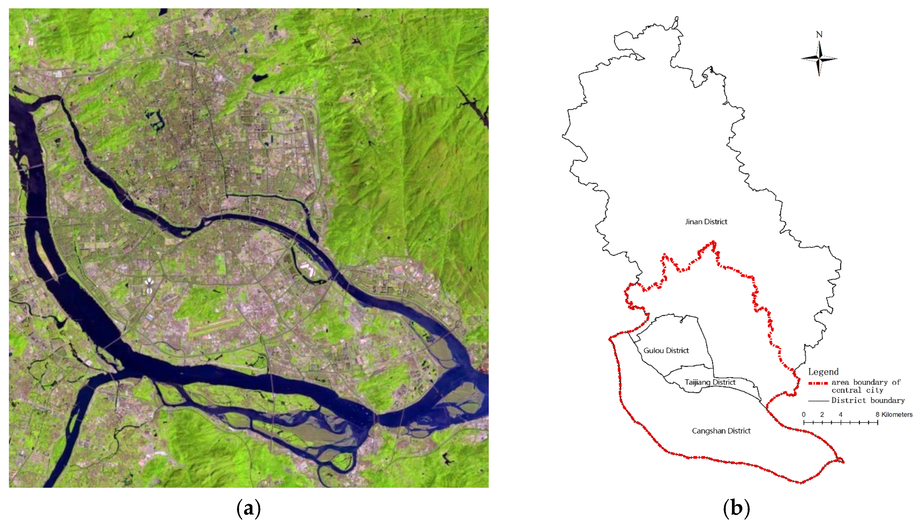
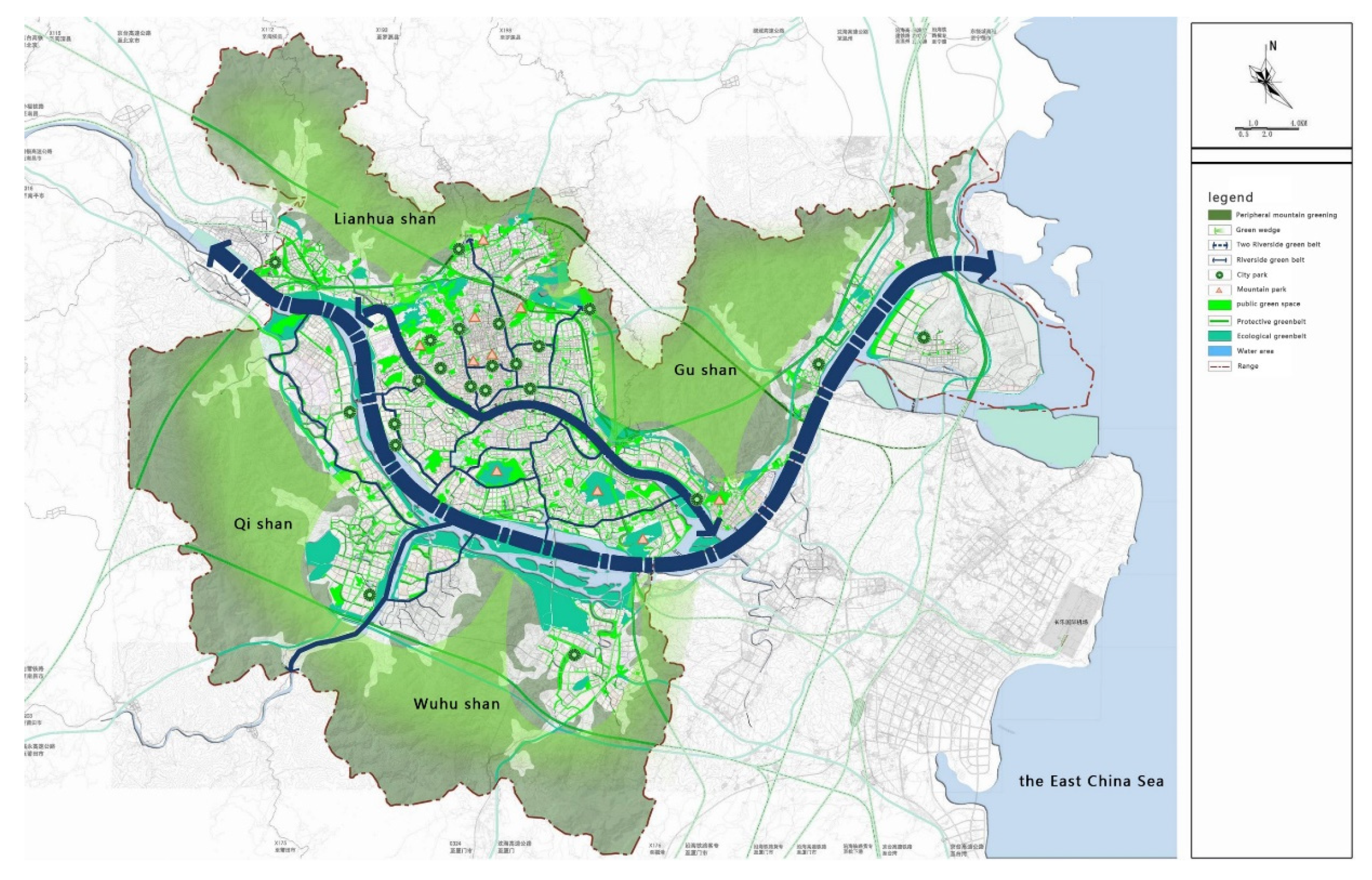
2.1. Study Area
2.2. Space Syntax
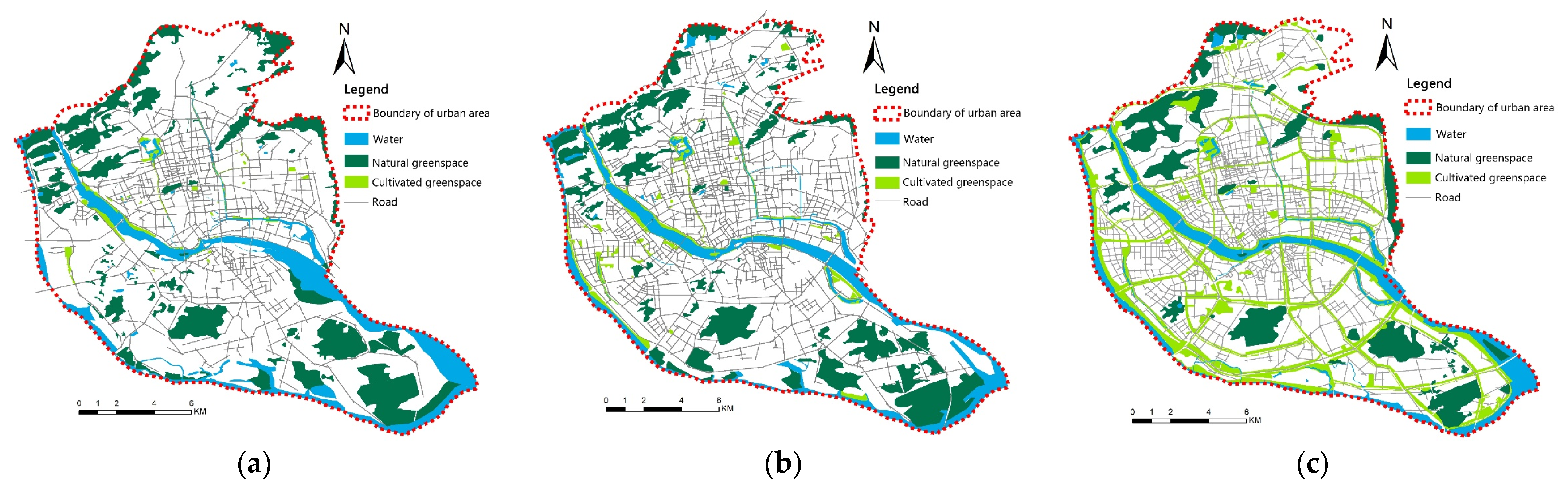
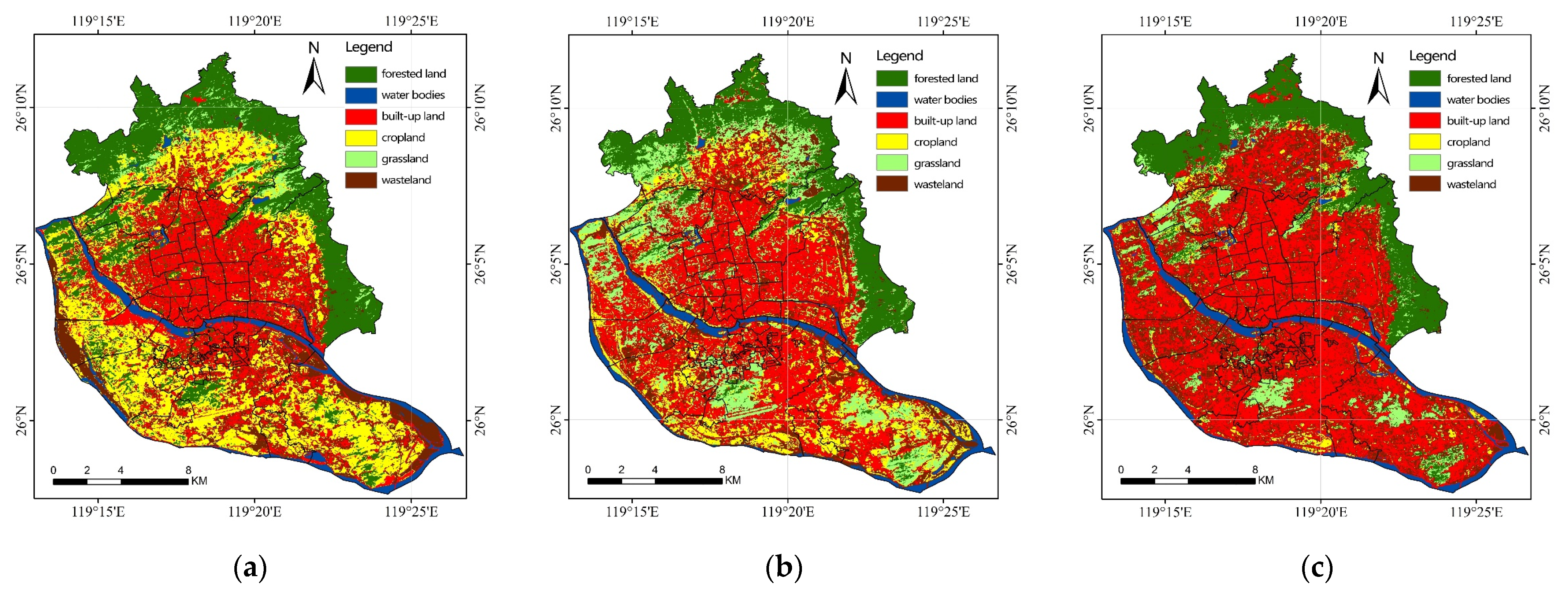
2.3. Land Use and Green Space Classification
2.4. Landscape Pattern Analysis
2.5. Network Analysis
2.6. Network Structure Analysis
3. Result
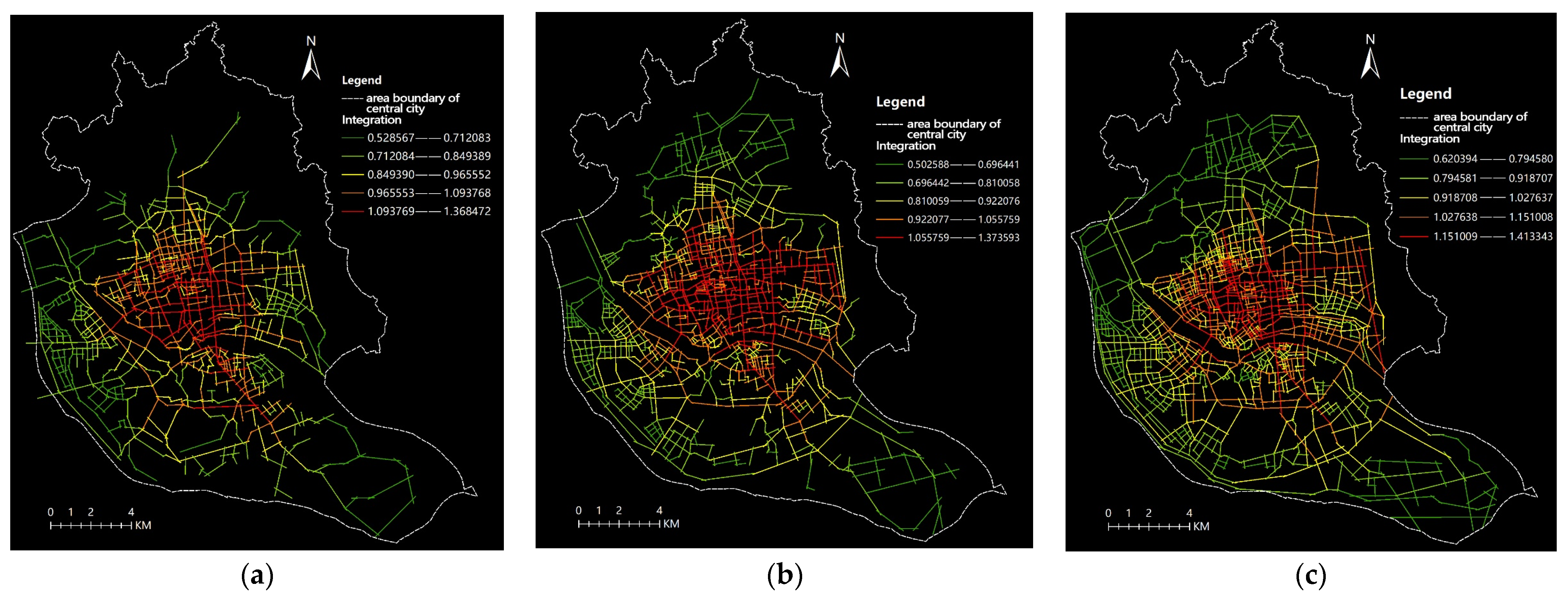
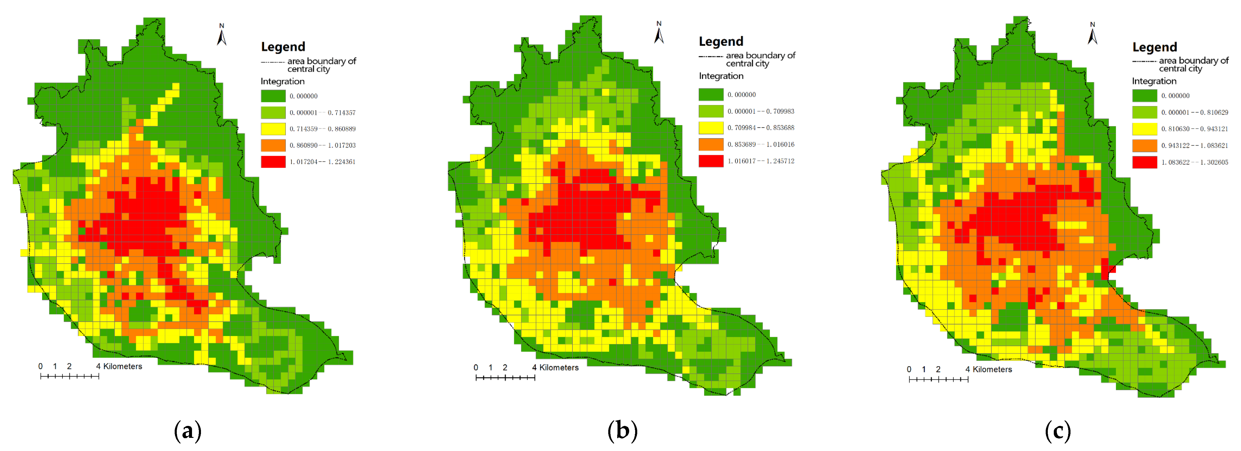
3.1. Evolution Analysis of Street Integration in the Central Area of Fuzhou City
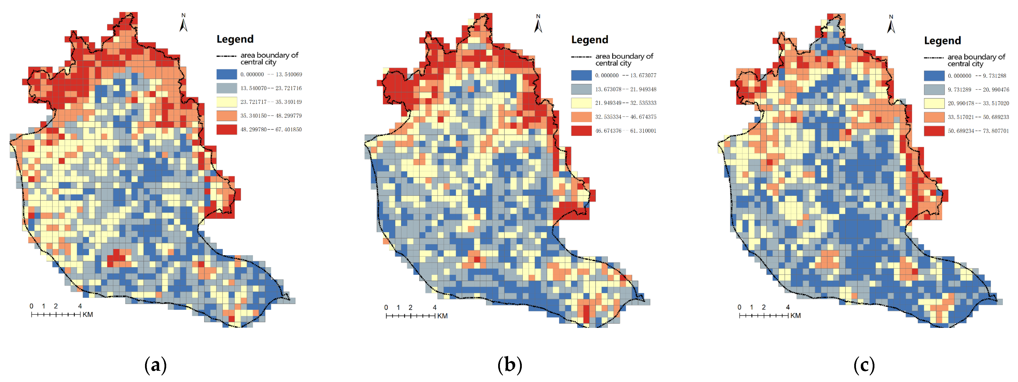
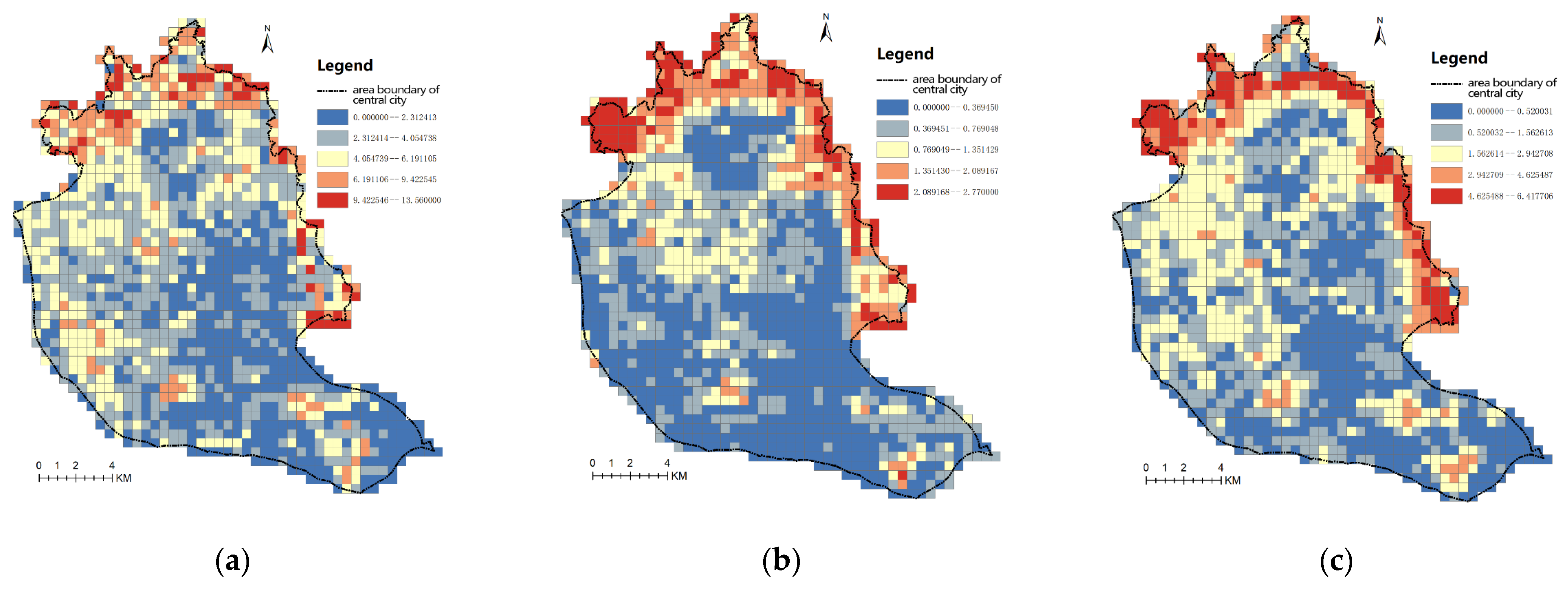
3.2. Evolution Analysis of Urban Green Space Fragmentation
3.2.1. Largest Patch Index
3.2.2. Landscape Shape Index
3.3. Optimization of Green Space Ecological Network
3.3.1. Landscape Pattern Analysis
Class-Level Metrics
Landscape-Level Metrics
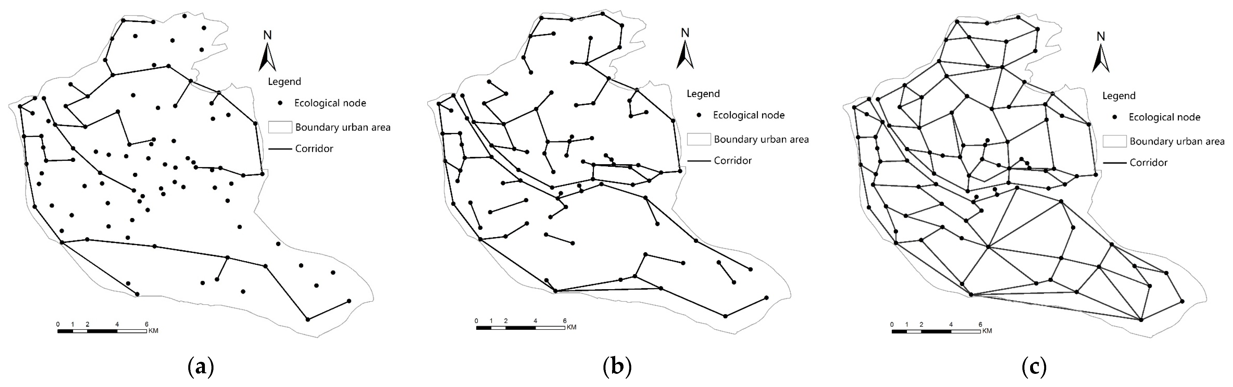
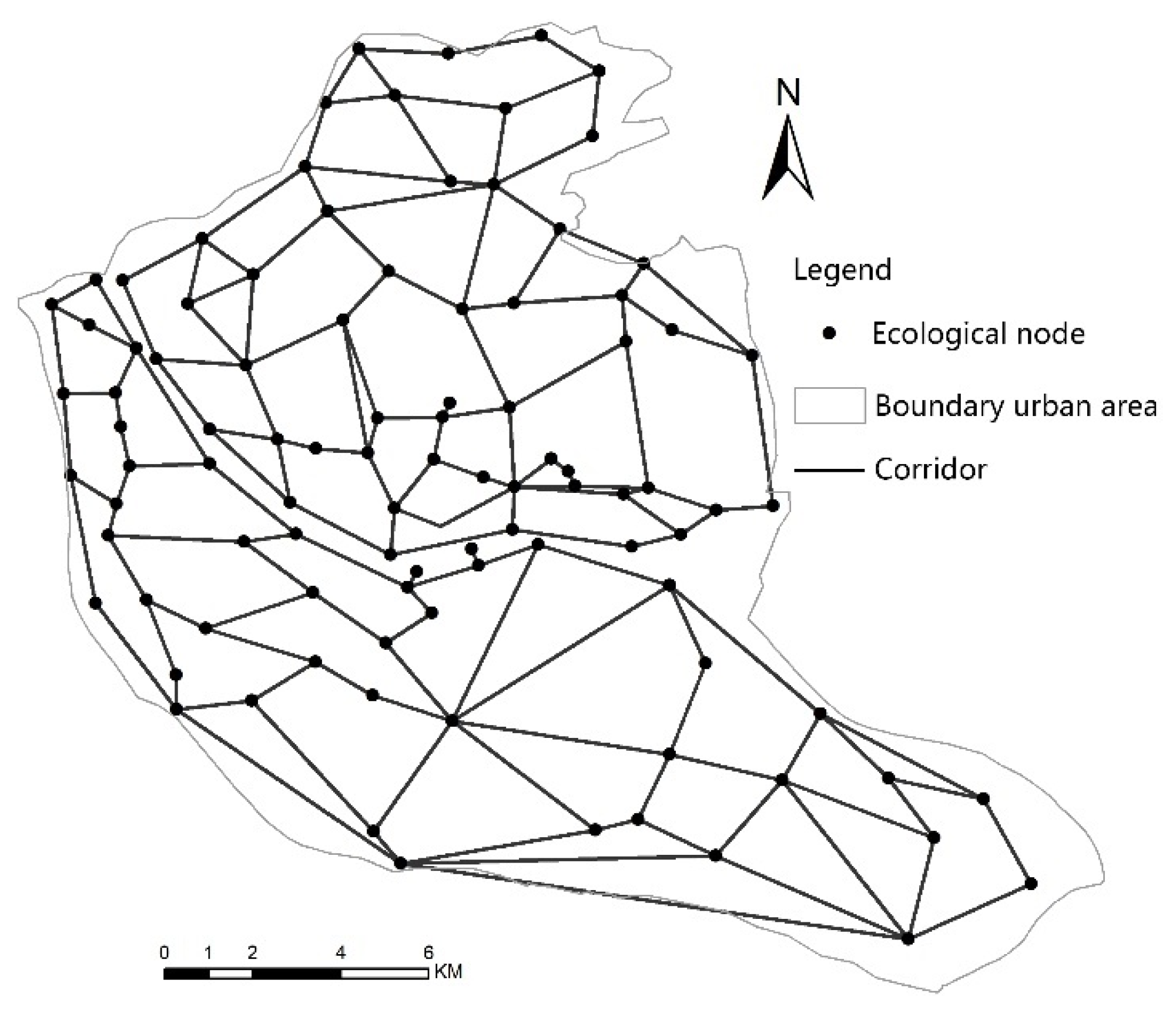
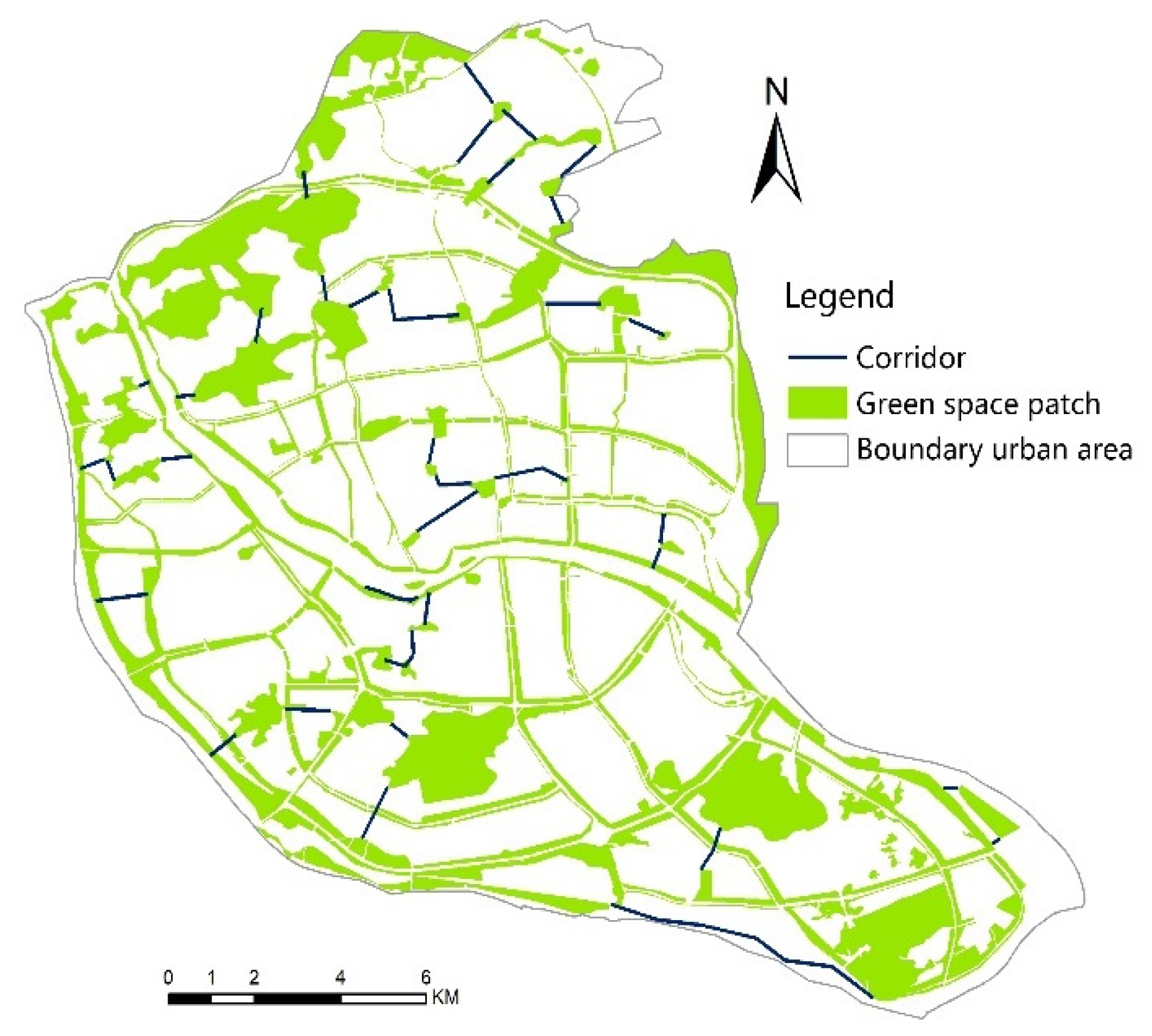
3.3.2. Ecological Corridor Analysis
Analysis of Ecological Corridors in Fuzhou City
Site Selection of Ecological Corridor in Fuzhou City
3.3.3. Analysis of Corridor Structure and Network Structure
3.3.4. Scheme of Green Space Ecological Network in Fuzhou
4. Discussion
5. Conclusions
- (1)
- From 2000 to 2020, a large amount of green space is occupied in the process of urbanization, which creates fragmentation;
- (2)
- Analysis of landscape index based on LPI and LSI, urbanization begins in the western region, but gradually continues into the southeast region. In fact, in 2010 this development was relatively rapid. In short, the spatial pattern of urban green space has changed greatly during the study period;
- (3)
- Through the qualitative and quantitative analysis of the green space landscape pattern in the study area, the green space ecological network was optimized. Green space ecological network planning can provide an effective method for the development of green space in Fuzhou and a balance between urban construction and the urban ecological environment that form part of the urbanization in Fuzhou. Therefore, the development of a green space ecological network is an effective form of green space planning that meets the needs of urban society. Green space ecological network planning has been widely applied and recognized as a new and effective method of urban green space system planning.
Author Contributions
Funding
Institutional Review Board Statement
Informed Consent Statement
Data Availability Statement
Conflicts of Interest
Appendix A

| Cang Shan District | ||||||
|---|---|---|---|---|---|---|
| Landscape Metrics | Natural Green Space | Cultivated Green Space | ||||
| 2000 | 2010 | Planning in 2021 | 2000 | 2010 | Planning in 2021 | |
| CA (ha) | 1280.52 | 795.21 | 582.99 | 120.69 | 678.53 | 1024.19 |
| PD (n/100 ha) | 0.09 | 0.16 | 0.53 | 0.32 | 0.85 | 1.33 |
| ED (m/ha) | 34.54 | 30.15 | 32.85 | 15.05 | 38.08 | 48.98 |
| MPS (ha) | 11.13 | 6.57 | 1.89 | 3.17 | 1.17 | 0.75 |
| MPFD | 1.06 | 1.04 | 1.04 | 1.02 | 1.04 | 1.05 |
| Gu Lou District | ||||||
|---|---|---|---|---|---|---|
| Landscape Metrics | Natural Green Space | Cultivated Green Space | ||||
| 2000 | 2010 | Planning in 2021 | 2000 | 2010 | Planning in 2021 | |
| CA (ha) | 609.64 | 266.40 | 181.31 | 147.61 | 367.33 | 892.59 |
| PD (n/100 ha) | 0.39 | 0.36 | 0.33 | 0.39 | 0.46 | 0.57 |
| ED (m/ha) | 68.57 | 53.10 | 34.69 | 30.87 | 65.79 | 85.81 |
| MPS (ha) | 1.46 | 2.77 | 3.02 | 2.55 | 2.17 | 1.75 |
| MPFD | 1.03 | 1.04 | 1.05 | 1.04 | 1.05 | 1.06 |
| Jin An District | ||||||
|---|---|---|---|---|---|---|
| Landscape Metrics | Natural Green Space | Cultivated Green Space | ||||
| 2000 | 2010 | Planning in 2021 | 2000 | 2010 | Planning in 2021 | |
| CA (ha) | 545.04 | 307.18 | 204.35 | 88.55 | 217.75 | 342.4 |
| PD (n/100 ha) | 0.16 | 0.79 | 0.58 | 0.26 | 0.36 | 0.65 |
| ED (m/ha) | 36.79 | 14.48 | 30.82 | 17.89 | 25.16 | 30.65 |
| MPS (ha) | 6.26 | 1.26 | 1.72 | 3.85 | 2.79 | 1.54 |
| MPFD | 1.04 | 1.04 | 1.05 | 1.04 | 1.04 | 1.05 |
| Tai Jiang District | ||||||
|---|---|---|---|---|---|---|
| Landscape Metrics | Natural Green Space | Cultivated Green Space | ||||
| 2000 | 2010 | Planning in 2021 | 2000 | 2010 | Planning in 2021 | |
| CA (ha) | 20.16 | 13.15 | 11.49 | 12.32 | 17.94 | 24.25 |
| PD (n/100 ha) | 0.28 | 0.38 | 0.57 | 0.48 | 0.42 | 0.41 |
| ED (m/ha) | 11.15 | 12.10 | 12.98 | 8.41 | 17.44 | 21.41 |
| MPS (ha) | 3.36 | 2.63 | 1.91 | 1.37 | 2.24 | 3.03 |
| MPFD | 1.03 | 1.01 | 1.03 | 1.04 | 1.03 | 1.05 |
| Landscape Metrics | Cang Shan District | Gu Lou District | Tai Jiang District | Jin An District | ||||||||
|---|---|---|---|---|---|---|---|---|---|---|---|---|
| 2000 | 2010 | Planning in 2021 | 2000 | 2010 | Planning in 2021 | 2000 | 2010 | Planning in 2021 | 2000 | 2010 | Planning in 2021 | |
| CA (ha) | 1401.21 | 1473.74 | 1607.18 | 757.25 | 633.73 | 1073.90 | 32.48 | 31.09 | 35.74 | 633.59 | 524.93 | 546.75 |
| PD (n/100 ha) | 0.11 | 0.48 | 1.03 | 0.39 | 0.42 | 0.53 | 0.36 | 0.39 | 0.48 | 0.17 | 0.61 | 0.63 |
| ED (m/ha) | 4.73 | 39.3 | 44.25 | 28.06 | 82.3 | 89.72 | 5.65 | 9.25 | 85.44 | 53.98 | 64.35 | 68.71 |
| MPS (ha) | 9.09 | 2.10 | 0.96 | 2.53 | 2.39 | 1.88 | 2.71 | 2.59 | 2.23 | 5.76 | 1.64 | 1.59 |
| LSI | 34.8 | 37.1 | 56.29 | 22.82 | 31 | 42.09 | 32.56 | 16.98 | 19.23 | 25.89 | 31.86 | 39.2 |
| SHDI | 0.06 | 0.29 | 0.69 | 0.21 | 0.55 | 0.68 | 0.26 | 0.46 | 0.63 | 0.57 | 0.63 | 0.68 |
| SHEI | 0.08 | 0.43 | 0.99 | 0.31 | 0.79 | 0.98 | 0.38 | 0.54 | 0.91 | 0.82 | 0.87 | 0.99 |
| MPFD | 1.04 | 1.04 | 1.05 | 1.04 | 1.04 | 1.05 | 1.03 | 1.03 | 1.04 | 1.04 | 1.04 | 1.05 |
| ENN(m) | 100 | 89.5 | 62.88 | 82.03 | 69.7 | 51.04 | 102.56 | 99.12 | 93.78 | 85.58 | 76.8 | 70.48 |
| CONNECT | 1.54 | 1.87 | 2.33 | 1.08 | 2.26 | 2.49 | 4.64 | 5.67 | 6.39 | 1.22 | 1.92 | 2.32 |
References
- McDonnell, M.J.; Pickett, S.; Groffman, P.; Bohlen, P. Ecosystem processes alongan urban-to-rural gradient. Urban Ecol. 1997, 1, 21–36. [Google Scholar] [CrossRef]
- Pickett, S.T.A.; Cadenasso, M.L.; Grove, J.M.; Nilon, C.H.; Pouyat, R.V.; Zipperer, W.C.; Costanza, R. Urban ecological systems: Linking terrestrial ecological, physical, and socioeconomic components of metropolitan areas. Annu. Rev. Ecol. Systemat. 2001, 32, 127–157. [Google Scholar] [CrossRef] [Green Version]
- Luck, M.; Wu, J. A gradient analysis of urban landscape pattern: A case study from the Phoenix metropolitan region, Arizona, USA. Landsc. Ecol. 2002, 17, 327–339. [Google Scholar] [CrossRef]
- Yu, D.; Xun, B.; Shi, P.; Shao, H.; Liu, Y. Ecological restoration planning based on connectivity in an urban area. Ecol. Eng. 2012, 46, 24–33. [Google Scholar] [CrossRef]
- Hillier, B. Space is the Machine: A Configurational Theory of Architecture, 3rd ed.; Yang, T., Wang, X., Zhang, J., Eds.; Architecture & Building Press: Beijing, China, 2008. [Google Scholar]
- He, Z.-Z.; Qiu, G.-C.; Yang, Z. Research of Xiamen urban morphology development based on space syntax analysis urban plan. Landsc. Archit. Virescence 2007, 25, 106–108. [Google Scholar]
- Jose, J.L. Socio Spatial segregation and urban form: Belem at the end of the 1990s. Geoforum 2001, 32, 493–507. [Google Scholar]
- Zhang, R.; Zhang, L.; Zhong, Q.; Zhang, Q.; Ji, Y.; Song, P.; Wang, Q. An optimized evaluation method of an urban ecological network: The case of the Minhang District of Shanghai. Urban For. Urban Green. 2021, 62, 1271. [Google Scholar] [CrossRef]
- Jongman, R.H.G. Ecological network are an issue for all of us. Landsc. Ecol. 2008, 1, 7–13. [Google Scholar] [CrossRef] [Green Version]
- Zhao, S.; Ma, Y.; Wang, J.; Youa, X. Landscape pattern analysis and ecological network planning of Tianjin City. Urban For. Urban Green. 2019, 46, 126479. [Google Scholar] [CrossRef]
- McHugh, A.N.; Thompson, S. A rapid ecological network assessment tool and its use in locating habitat extension areas in a changing landscape. Nat. Conserv. 2011, 19, 236–244. [Google Scholar] [CrossRef]
- Kong, F.; Yin, H.; Nakagoshi, N.; Zong, Y. Urban green space network development for biodiversity conservation: Identification based on graph theory and gravity modeling. Landsc. Urban Plann. 2009, 95, 16–27. [Google Scholar] [CrossRef]
- Kong, F.; Yin, H. Developing green space ecological networks in Jinan City. Acta Ecol. Sin. 2008, 28, 1711–1719. [Google Scholar]
- Yin, H.; Kong, F.; Qi, Y.; Wang, H.; Zhou, Y.; Qin, Z. Developing and optimizing ecological networks in urban agglomeration of Hunan Province, China. Acta Ecol. Sin. 2011, 31, 2863–2874. [Google Scholar]
- George, L.; Sarah, B.; Jonathan, L.A.; Kurt, R.; Elbroch, M. Testing GIS-generated least-cost path predictions for Martes pennanti (Fisher) and its application for identifying mammalian road-crossings in northern New Hampshire. Northeast. Nat. 2012, 19, 147–156. [Google Scholar]
- Chang, X.; Wang, Y.; Li, Z. Landscape pattern optimization based upon the concept of landscape functions network: A case study in Taiwan, China. Acta Ecol. Sin. 2005, 25, 1707–1713. [Google Scholar]
- Zhang, L.; Su, L.; Wang, J.; Chen, M. Establishment of ecological network based on landscape ecology in Anshan. Chin. J. Ecol. 2014, 33, 1337–1343. [Google Scholar]
- Zhou, Y.; Zhang, Q. Impacts of road networks on species migration and landscape connectivity. Chin. J. Ecol. 2014, 33, 440–446. [Google Scholar]
- Chen, C.; Wu, S.; Meurk, C.D.; Lu, M.; Wen, Z.; Jiang, Y.; Chen, J. Effects of changing cost values on landscape connectivity simulation. Acta Ecol. Sin. 2015, 35, 7367–7376. [Google Scholar]
- Hepcan, S.; Hepcana, C.C.; Bouwmab, I.M.; Jongman, R.H.G.; Özkana, M.B. Ecological networks as a new approach for nature conservation in Turkey: A case study of lzmir Province. Landsc. Urban Plan. 2009, 90, 143–154. [Google Scholar] [CrossRef]
- Tian, Y.H.; Jim, C.Y.; Tao, Y.; Shi, T. Landscape ecological assessment of green space fragmentation in Hong Kong. Urban For. Urban Green 2011, 10, 79–86. [Google Scholar] [CrossRef]
- Comber, A.; Brunsdon, C.; Green, E. Using a GIS-based network analysis to determine urban greenspace accessibility for different ethnic and religious groups. Landsc. Urban Plan. 2008, 86, 103–114. [Google Scholar] [CrossRef] [Green Version]
- Zhang, L.Q.; Wang, H.Z. Planning an ecological network of Xiamen Island (China) using landscape metrics and network analysis. Landsc. Urban Plan. 2006, 78, 449–456. [Google Scholar] [CrossRef]
- Alvey, A. Promoting and preserving biodiversity in the urban forest. Urban Urban Green 2006, 5, 195–201. [Google Scholar] [CrossRef]
- Carlier, J.; Moran, J. Landscape typology and ecological connectivity assess ment to inform Greenway design. Sci. Total Environ. 2019, 651, 3241–3252. [Google Scholar] [CrossRef] [PubMed]
- Mõisja, K.; Uuemaa, E.; Oja, T. Integrating small-scale landscape elements into land use/cover: The impact on landscape metrics’ values. Ecol. Indic. 2016, 67, 714–722. [Google Scholar] [CrossRef]
- Weber, T.; Sloan, A.; Wolf, J. Maryland’s green infrastructure assessment: Development of a comprehensive approach to land conservation. Landsc. Urban Plan. 2006, 77, 94–110. [Google Scholar] [CrossRef]
- Li, H.; Chen, W.; He, W. Planning of Green Space Ecological Network in Urban Areas: An Example of Nanchang, China. Int. J. Environ. Res. Public Health 2015, 12, 12889–12904. [Google Scholar] [CrossRef] [Green Version]
- Cook, E.A. Landscape structure indices for assessing urban ecological networks. Landsc. Urban Plan. 2002, 58, 269–280. [Google Scholar] [CrossRef]
- Cai, Y.-B. Study on Spatial Pattern of Urban Green Space in Fuzhou. 2019. Available online: https://www.360kuai.com/pc/99c4965c3f2575f53?cota=4&kuai_so=1&tj_url=so_rec&sign=360_7bc3b157 (accessed on 21 November 2019).
- Chetty, R.; Hendren, N.; Kline, P. Where is The Land of Opportunity? The Geography of Intergenerational Mobility in the United States. Q. J. Econ. 2014, 129, 1553–1623. [Google Scholar] [CrossRef] [Green Version]
- Jiang, B.; Claramunt, C.B. Integration of space syntax into GIS: New perspectives for urban morphology. Trans. GIS 2002, 6, 295–309. [Google Scholar] [CrossRef]
- Kim, H.-K.; Dong, W.-S. An analysis of the relationship between land use density of office configuration. Cities 2002, 19, 409–418. [Google Scholar] [CrossRef]
- Porras, R.; Takeshita, T.; Ikezoe, M. A study on the pedestrian space applying space syntax and the segment unit. J. Asian Archit. Build. Eng. 2002, 1, 197–203. [Google Scholar] [CrossRef]
- Raford, N.; Ragland, D.R. Space Syntax: An Innovative Pedestrian Volume Modeling Tool for Pedestrian Safety; Safe Transportation Research & Education Center: Berkeley, CA, USA, 2003; Available online: https://escholarship.org/uc/item/50m064zp (accessed on 11 December 2003).
- Hillier, B.; Hanson, J. The Social Logic of Space; Cambridge University Press: Cambridge, UK, 1984. [Google Scholar]
- Hillier, B. Space is the machine: A configurational theory of architecture. J. Urban Des. 2007, 3, 333–335. [Google Scholar]
- Geneletti, D. Using spatial indicators and value functions to assess ecosystem fragmentation caused by linear infrastructures. Int. J. Appl. Earth Obs. Geoinf 2004, 5, 1–15. [Google Scholar] [CrossRef]
- Yee, A.M. Space Syntax: A Very Short Introduction; Institute of Architecture Shenzhen University: Shenzhen, China, 3 September 2014. [Google Scholar]
- DepthmapX: Visual and Spatial Network Analysis Software. Available online: https://www.ucl.ac.uk/bartlett/architecture/research/space-syntax/depthmapx (accessed on 21 November 2019).
- Geospatial Data Cloud. Available online: http://www.gscloud.cn (accessed on 23 May 2021).
- Liu, C.; Jia, W.; Lu, S.; Lv, S. Construction and optimization of green space ecological networks in urban fringe areas: A case study with the urban fringe area of Tongzhou district in Beijing. J. Clean. Prod. 2020, 276, 124266. [Google Scholar]
- Conine, A.; Xiang, W.N.; Young, J.; Whitley, D. Planning for multipurpose greenways in Concord, North Carolina. Landsc. Urban Plan. 2004, 68, 271–287. [Google Scholar] [CrossRef]
- Kong, F.H.; Yin, H.W.; Nakagoshi, N. Using GIS and landscape metrics in the hedonic price modeling of the amenity value of urban green space—A case study in Jinan City, China. Landsc. Urban Plan. 2007, 79, 240–252. [Google Scholar] [CrossRef]
- Garigal, K.M. FRAGSTATS HELP; Department of Environmental Conservation University of Massachusetts: Amherst, MA, USA, 2015. [Google Scholar]
- Xu, J. Graph Theory and Its Application; China University of science and Technology Press: Hefei, China, 2004. [Google Scholar]
- Haggett, P.; Chorley, R.J. Network Analysis in Geography; Edward Arnold: London, UK, 1972. [Google Scholar]
- Wang, H.-Z. Urban Ecological Network Research; East China Normal University Press: Shanghai, China, 2005. [Google Scholar]
- Forman, R.T.T.; Godron, M. Landscape Ecology; Wiley: New York, NY, USA, 1986. [Google Scholar]
- Dalton, R.; Garlick, J.; Minshull, R.; Robinson, A. Networks in Geography; Phillip: London, UK, 1973. [Google Scholar]
- Li, Y.-F.; Liu, G.-H. Characterizing Spatiotemporal Pattern of Land Use Change and Its Driving Force Based on GIS and Landscape Analysis Techniques in Tianjin during 2000–2015. Sustainability 2017, 9, 894. [Google Scholar] [CrossRef] [Green Version]
- Xie, H.L.; Liu, Z.F.; Wang, P.; Liu, G.Y.; Lu, F.C. Exploring the mechanisms of ecological land change based on the spatial autoregressive model: A case study of the Poyang Lake Eco-Economic Zone, China. Int. J. Environ. Res. Public Health 2014, 11, 583–599. [Google Scholar] [CrossRef]
- Ignatieva, M.; Stewart, G.H.; Meurk, C. Planning and design of ecological networks in urban areas. Landsc. Ecol. Eng. 2011, 7, 17–25. [Google Scholar] [CrossRef]
- Hitchings, R. Studying the preoccupations that prevent people from going into green space. Landsc. Urban Plan. 2013, 118, 98–102. [Google Scholar] [CrossRef] [Green Version]
- Zeng, H.; Wu, X.B. Utilities of edge-based metrics for studying landscape fragmentation. Comput. Environ. Urban Syst. 2005, 29, 159–178. [Google Scholar] [CrossRef]
- Jaeger, J.A.G.; Bertiller, R.; Schwick, C.; Müller, K.; Steinmeier, C.; Ewald, K.C.; Ghazoul, J. Implementing landscape fragmentation as an indicator in the Swiss monitoring system of sustainable development (MONET). J. Environ. Manag. 2008, 88, 737–751. [Google Scholar] [CrossRef] [PubMed]
- Tian, Y.; Jim, C.Y. Development potentials of sky gardens in the compact city of Hong Kong. Urban For. Urban Green. 2012, 11, 223–233. [Google Scholar] [CrossRef]
- Tian, Y.H.; Jim, C.Y.; Tao, Y. Challenges and strategies for greening the compact city of Hong Kong. J. Urban Plan. Dev. 2012, 138, 101–109. [Google Scholar] [CrossRef]
- Fuller, R.A.; Irvine, K.N.; Devine-Wright, R.; Gaston, K.J. Psychological benefits of greenspace increase with biodiversity. Biol. Lett. 2007, 3, 390–394. [Google Scholar] [CrossRef]


| Landscape Metrics (Abbreviation) | Description | Expression |
|---|---|---|
| Class area (CA) | CA equals the sum of the areas (m2) of all patches of the corresponding patch type, divided by 10,000 (to convert to hectares); that is, total class area. | |
| Patch density (PD) | The number of patches per 100 ha. It is a simple measure of the fragmentation of the patch type. | × 1,000,000 |
| Edge density (ED) | ED equals the sum of the lengths (m) of all edge segments in the landscape, divided by the total landscape area (m2), multiplied by 10,000 (to convert to hectares). | × 10,000 |
| Mean patch size (MPS) | The area occupied by a particular patch type divided by the number of patches of that type. It is a simple measure of the fragmentation of the patch type. | |
| Shannon’s diversity index (SHDI) | SHDI equals minus the sum, across all patch types, of the proportional abundance of each patch type multiplied by that proportion. | |
| Shannon’s evenness index (SHEI) | SHEI equals minus the sum, across all patch types, of the proportional abundance of each patch type multiplied by that proportion, divided by the logarithm of the number of patch types. | |
| Landscape Shape Index (LSI) | Landscape shape index provides a standardized measure of total edge or edge density that adjusts for the size of the landscape. | |
| Mean fractal dimension index (MPFD) | In landscape ecological research, patch shapes are frequently characterized via the fractal dimension of the object. | |
| Euclidean Nearest-Neighbor Distance (ENN) | ENN equals the distance (m) to the nearest neighboring patch of the same type, based on shortest edge-to-edge distance. | |
| Connectance Index (CONNECT) | CONNECT equals the number of functional joining between all patches of the corresponding patch type divided by the total number of possible joining between all patches of the corresponding patch type, multiplied by 100 to convert to a percentage. | CONNECT = |
| Largest patch index (LPI) | LPI is calculated as the area of the largest patch divided by the total landscape area, multiplied by 100. | , |
| Index | Meaning | Calculation Formula | Analysis of Calculation Results | Notes |
|---|---|---|---|---|
| α | network circuitry | α | 0 ≤ α ≤ 1; α = 0, network with no loops; α = 1, network with the maximum possible number of loops present. | L: number of corridors V: number of nodes |
| β | node/line ratio | β | 0 ≤ β ≤ 3; β = 0, no network; β < 1, the network takes on a dendroid pattern; β = 1, single loop in the network; β > 1, more complex connectivity in the network [47]. | |
| γ | network connectivity | γ | 0 ≤ γ ≤ 3; γ = 0, none of the nodes are linked; γ = 1, every node is linked to every other possible node. |
| 2000 | 2010 | 2021 | ||
|---|---|---|---|---|
| Global Integration | Number | 798 | 1112 | 1243 |
| Mean | 0.729 | 0.889 | 0.962 | |
| Max | 1.368 | 1.374 | 1.413 | |
| Min | 0.529 | 0.503 | 0.62 | |
| Std. deviation | 0.165 | 0.163 | 0.149 |
| Land Type | 2000 | 2010 | 2021 | |
|---|---|---|---|---|
| Forested land | Area (m2) | 7054.59 | 5022.99 | 4844.85 |
| Proportion (%) | 22.73 | 16.19 | 15.61 | |
| Water bodies | Area (m2) | 1924.97 | 1395.09 | 1069.51 |
| Proportion (%) | 6.20 | 4.50 | 3.45 | |
| Built-up land | Area (m2) | 8924.31 | 10,752.03 | 14,344.57 |
| Proportion (%) | 28.76 | 34.65 | 46.22 | |
| Farmland | Area (m2) | 9052.03 | 3802.95 | 1037.29 |
| Proportion (%) | 29.17 | 12.25 | 3.34 | |
| Grassland | Area (m2) | 2131.92 | 4705.20 | 5409.30 |
| Proportion (%) | 6.87 | 15.16 | 17.43 | |
| Unused land | Area (m2) | 6710.22 | 5355.18 | 4327.92 |
| Proportion (%) | 21.62 | 17.26 | 13.95 |
| Land Use | 2000 | 2010 | 2021 |
|---|---|---|---|
| Forested land | 13.56 | 9.36 | 6.59 |
| Water bodies | 1.43 | 0.92 | 0.42 |
| Farmland | 7.97 | 0.53 | 0.17 |
| Grassland | 1.06 | 1.62 | 3.83 |
| landscape | 18.76 | 29.40 | 41.36 |
| Land Use | 2000 | 2010 | 2021 |
|---|---|---|---|
| Forested land | 62.95 | 51.37 | 36.05 |
| Water bodies | 18.40 | 17.04 | 16.58 |
| Farmland | 72.21 | 59.25 | 42.21 |
| Grassland | 41.48 | 61.31 | 73.81 |
| landscape | 79.53 | 84.11 | 111.69 |
| Fuzhuo Green Space Ecological Network Plan Sketch | Nodes | Corridor Number | α Index | β Index | γ Index |
|---|---|---|---|---|---|
| Ⅰ | 46 | 44 | 0.00 | 0.95 | 0.33 |
| Ⅱ | 99 | 98 | 0.00 | 0.98 | 0.34 |
| Ⅲ | 99 | 155 | 0.29 | 1.56 | 0.53 |
| Nodes | Corridor Number | Corridor Length (km) | Corridor Density (km·km2) | α Index | β Index | γ Index | Cost Ratio | |
|---|---|---|---|---|---|---|---|---|
| Cang Shan District | 50 | 71 | 165.56 | 1.16 | 0.23 | 1.42 | 0.49 | 0.57 |
| Gu Lou District | 15 | 34 | 56.93 | 1.62 | 0.80 | 2.26 | 0.87 | 0.40 |
| Tai Jiang District | 8 | 16 | 23.94 | 1.33 | 0.82 | 2.00 | 0.88 | 0.33 |
| Jinan District | 26 | 34 | 60.71 | 1.05 | 0.19 | 1.31 | 0.47 | 0.45 |
| Landscape Metrics | Gu Lou District | Tai jiang District | ||
|---|---|---|---|---|
| Green Space System Planning in 2021 | Ecological Network Planning | Green Space System Planning in 2021 | Ecological Network Planning | |
| PD (n/100 ha) | 0.53 | 0.42 | 0.48 | 0.43 |
| ED (m/ha) | 89.72 | 94.74 | 85.44 | 89.52 |
| MPS (ha) | 1.88 | 2.53 | 2.23 | 3.32 |
| LSI | 42.09 | 45.14 | 19.23 | 23.43 |
| SHDI | 0.68 | 0.83 | 0.63 | 0.72 |
| SHEI | 0.98 | 1.34 | 0.91 | 0.98 |
| MPFD | 1.05 | 1.06 | 1.04 | 1.05 |
| ENN(m) | 51.04 | 45.67 | 93.78 | 86.42 |
| CONNECT | 2.49 | 3.36 | 6.39 | 6.91 |
| Landscape Metrics | Cang Shan District | Jin An District | ||
|---|---|---|---|---|
| Green Space System Planning in 2021 | Ecological Network Planning | Green Space System Planningin 2021 | Ecological Network Planning | |
| PD (n/100 ha) | 1.03 | 0.82 | 0.63 | 0.46 |
| ED (m/ha) | 44.25 | 46.34 | 68.71 | 71.28 |
| MPS (ha) | 0.96 | 1.65 | 1.59 | 2.78 |
| LSI | 56.29 | 58.93 | 39.2 | 42.37 |
| SHDI | 0.69 | 0.75 | 0.68 | 0.82 |
| SHEI | 0.99 | 1.23 | 0.99 | 1.35 |
| MPFD | 1.05 | 1.06 | 1.05 | 1.07 |
| ENN (m) | 62.88 | 56.32 | 70.48 | 65.67 |
| CONNECT | 2.33 | 3.88 | 2.32 | 3.92 |
Publisher’s Note: MDPI stays neutral with regard to jurisdictional claims in published maps and institutional affiliations. |
© 2021 by the authors. Licensee MDPI, Basel, Switzerland. This article is an open access article distributed under the terms and conditions of the Creative Commons Attribution (CC BY) license (https://creativecommons.org/licenses/by/4.0/).
Share and Cite
Huang, B.-X.; Chiou, S.-C.; Li, W.-Y. Landscape Pattern and Ecological Network Structure in Urban Green Space Planning: A Case Study of Fuzhou City. Land 2021, 10, 769. https://doi.org/10.3390/land10080769
Huang B-X, Chiou S-C, Li W-Y. Landscape Pattern and Ecological Network Structure in Urban Green Space Planning: A Case Study of Fuzhou City. Land. 2021; 10(8):769. https://doi.org/10.3390/land10080769
Chicago/Turabian StyleHuang, Bo-Xun, Shang-Chia Chiou, and Wen-Ying Li. 2021. "Landscape Pattern and Ecological Network Structure in Urban Green Space Planning: A Case Study of Fuzhou City" Land 10, no. 8: 769. https://doi.org/10.3390/land10080769
APA StyleHuang, B.-X., Chiou, S.-C., & Li, W.-Y. (2021). Landscape Pattern and Ecological Network Structure in Urban Green Space Planning: A Case Study of Fuzhou City. Land, 10(8), 769. https://doi.org/10.3390/land10080769