
Application of Suitability Modeling in Establishing a New Bicycle–Pedestrian Path: The Case of the Abandoned Kanfanar–Rovinj Railway in Istria


Abstract
1. Introduction
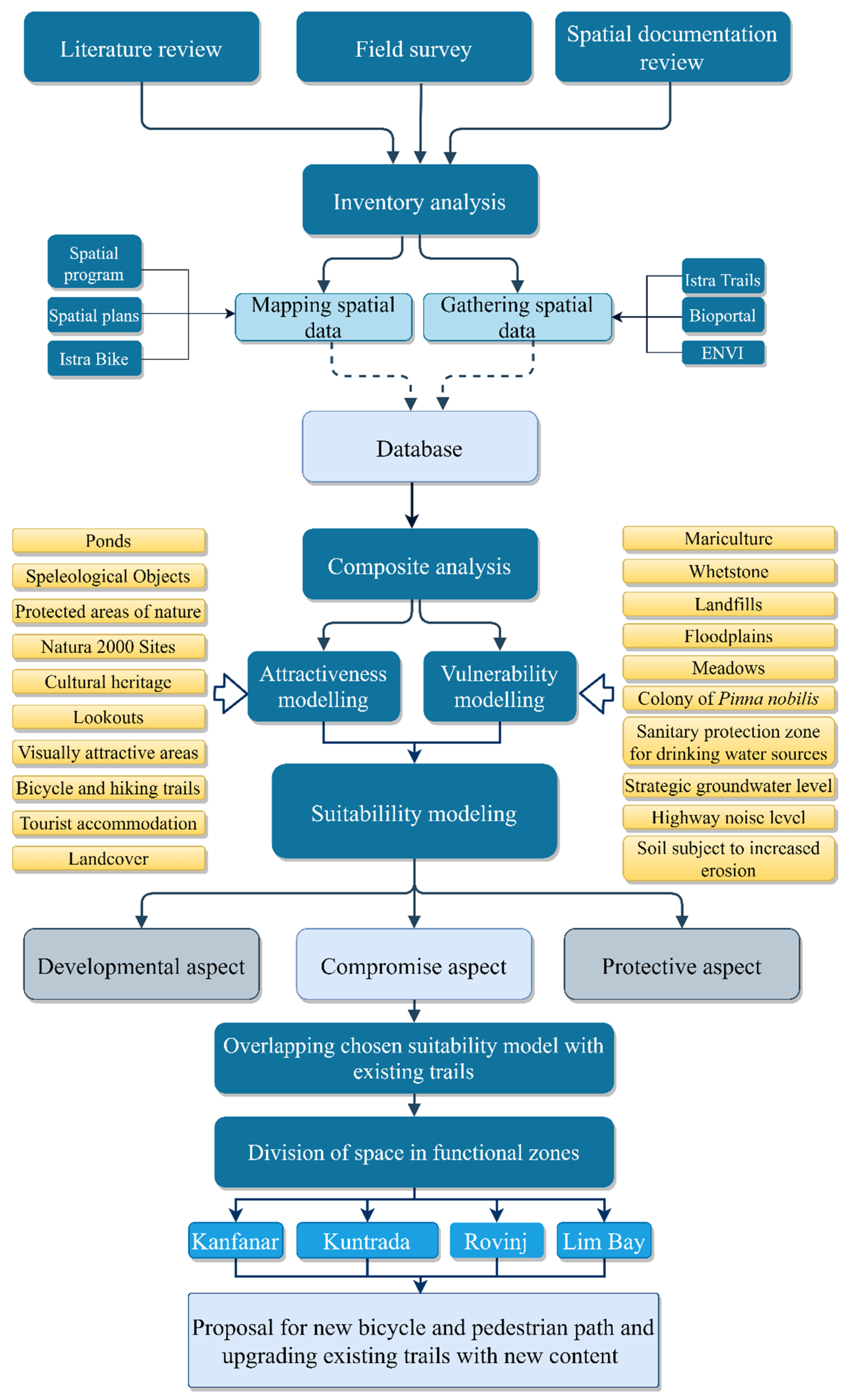
2. Materials and Methods
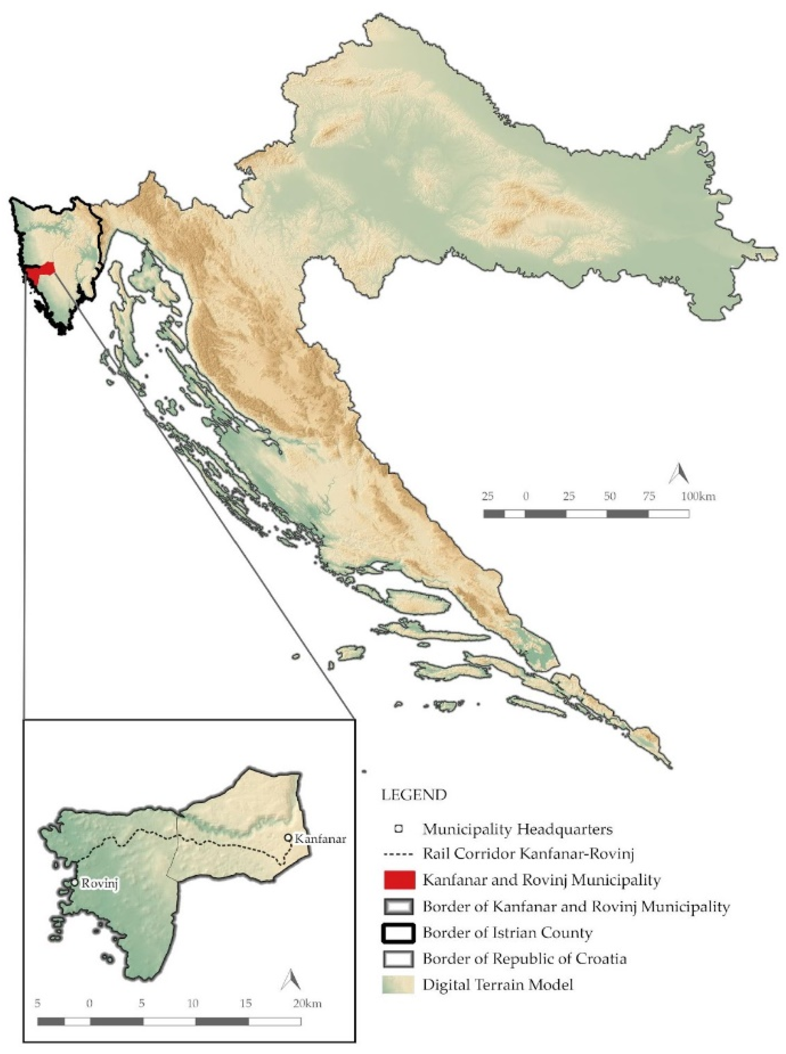
2.1. Case Study
2.2. Data Compilation
2.3. Analysis
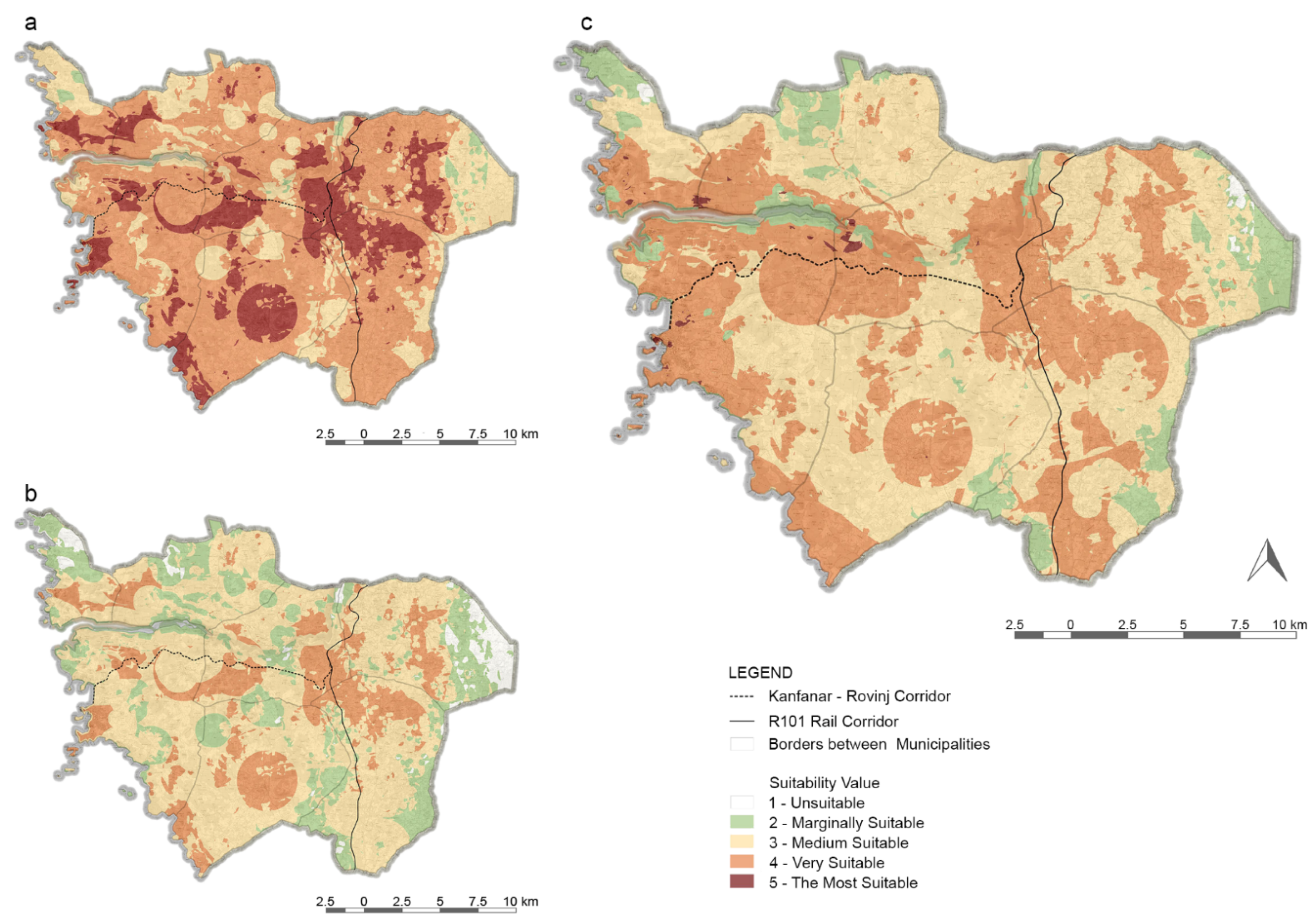
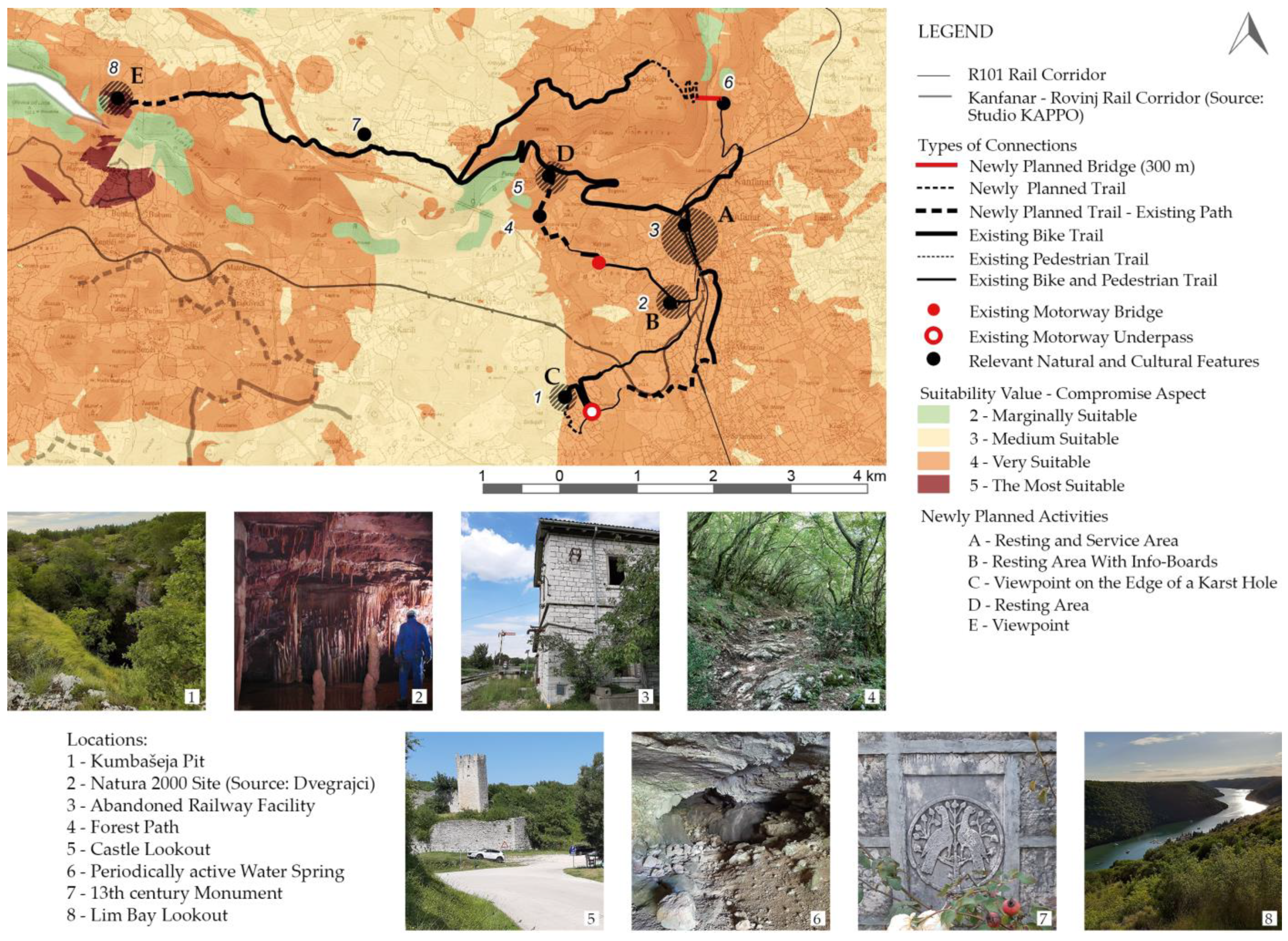
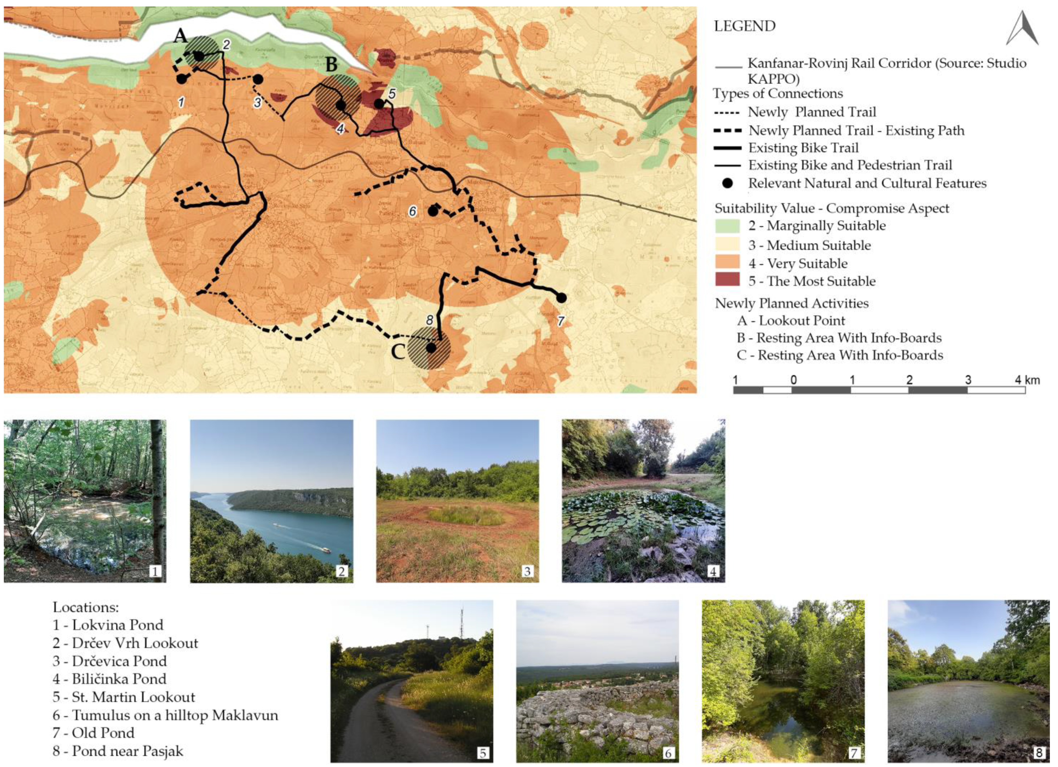
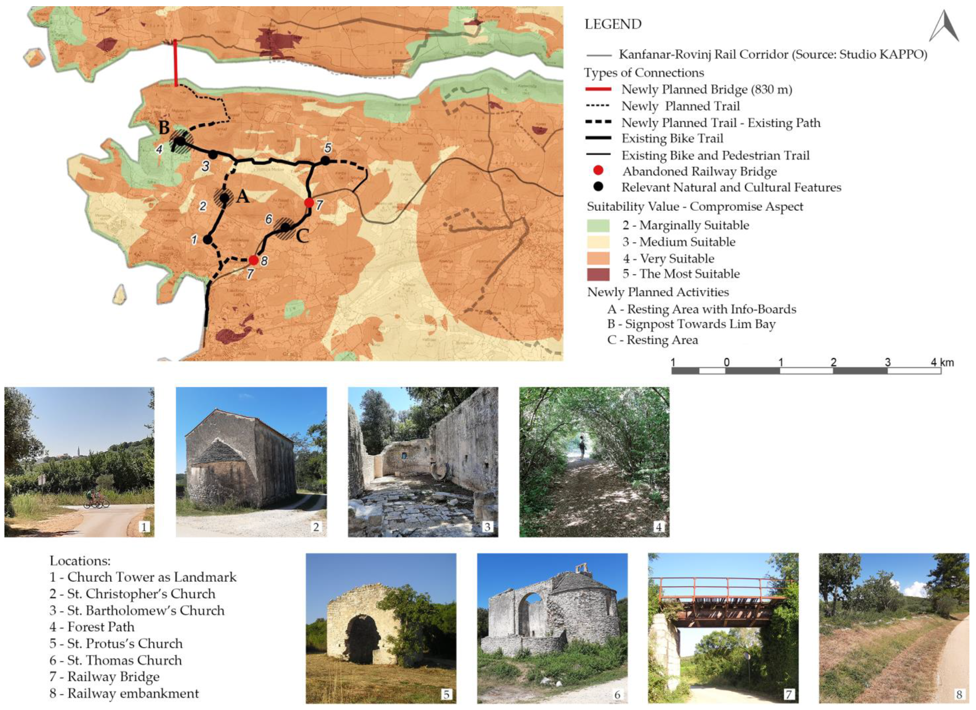
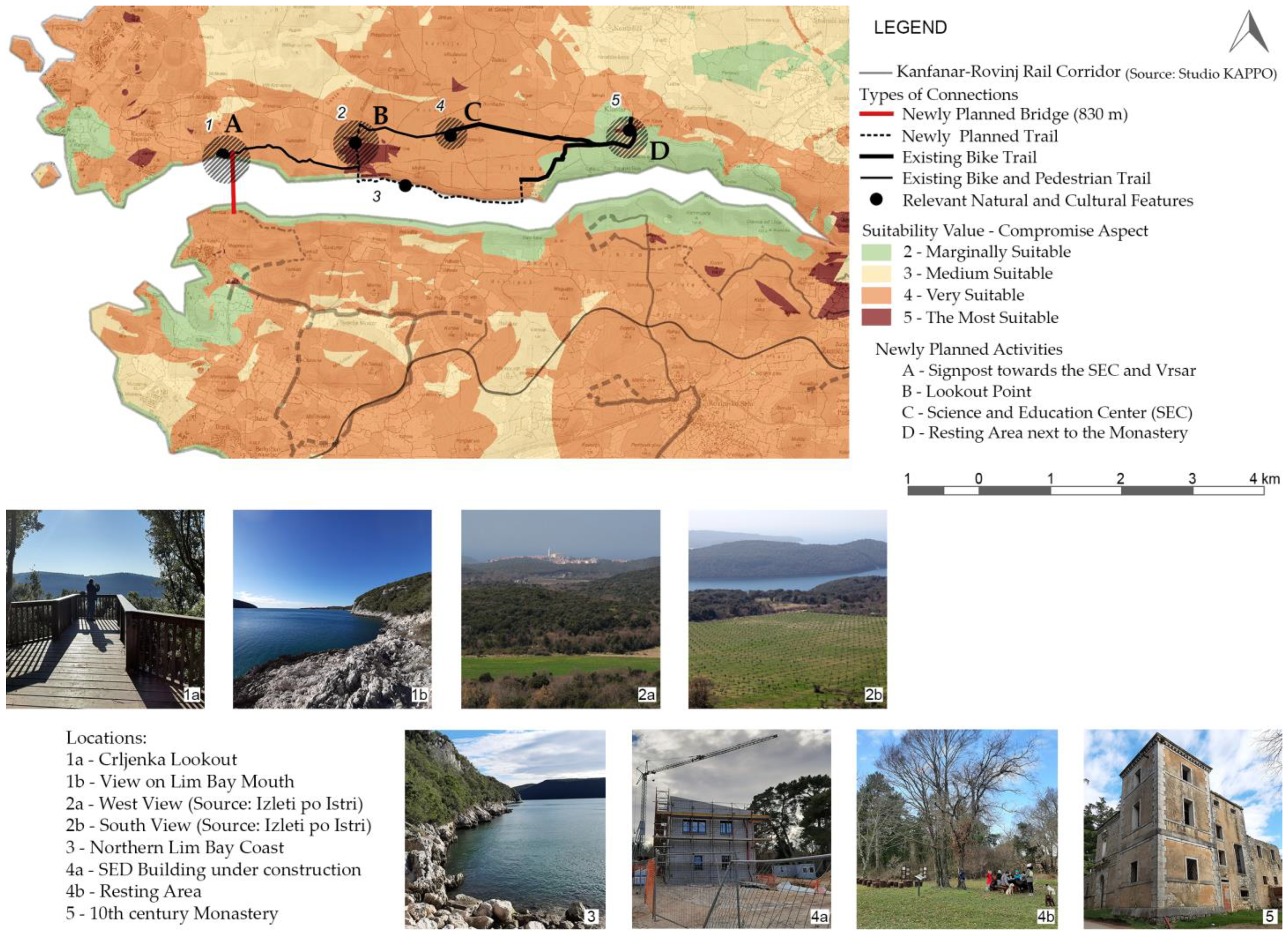
3. Results
4. Discussion
5. Conclusions
Author Contributions
Funding
Data Availability Statement
Conflicts of Interest
References
- Blackwell, C.C. After use of surplus railway land. Landsc. Res. 1977, 2, 4–6. [Google Scholar] [CrossRef]
- Rovelli, R.; Senes, G.; Fumagalli, N.; Sacco, J.; De Montis, A. From railways to greenways: A complex index for supporting policy making and planning. A case study in Piedmont (Italy). Land Use Policy 2020, 99, 104835. [Google Scholar] [CrossRef]
- Orbanić, J. Cars in Istria. In Traffic in Istria: From Argonauts to Ipsilon, 1st ed.; Bratulić, J., Cvek, E., Ladavac, A., Anzur, A., Maras, I., Mirković, M., Eds.; C.A.S.H.: Pula, Croatia, 2005; p. 86. [Google Scholar]
- Rovinj Heritage Museum. Available online: http://admindogadaji.muzej-rovinj.hr/UserFiles/Dogadaj/1046/Katalog.pdf (accessed on 26 April 2021).
- Official Website of Region of Istria. Economy. Available online: https://www.istra-istria.hr/en/region-of-istria/general-information/economy/ (accessed on 22 November 2020).
- Studio za Krajobraznu Arhitekturu, Prostorno Planiranje, Okoliš d.o.o. The Concept Design of Conversion of the Abandoned Railway Kanfanar-Rovinj INTO a Bicycle—Pedestrian Path; Studio za Krajobraznu Arhitekturu, Prostorno Planiranje, Okoliš d.o.o: Rovinj, Croatia, 2019; Available online: https://www.kanfanar.hr/wp-content/uploads/2020/02/IDEJNO-RJE%C5%A0ENJE-pruga-Kanfanar-Rovinj.pdf (accessed on 26 April 2021).
- Pekin Timur, U.; Özden, E.; Erzin, P.E.; Timur, Ö.B. Investigation of Çankıri City Railway in Scope of Greenway. Sustainability 2021, 13, 3055. [Google Scholar] [CrossRef]
- Zhang, C.; Dai, S.; Xia, H. Reuse of Abandoned Railways Leads to Urban Regeneration: A Tale from a Rust Track to a Green Corridor in Zhangjiakou. Urban Rail Transit 2020, 6, 104–115. [Google Scholar] [CrossRef]
- DiRuocco, G.; Sicignano, E.; Fiore, P.; D’Andria, E. Sustainable Reuse of Disused Railway. Procedia Eng. 2017, 180, 1643–1652. [Google Scholar] [CrossRef]
- Groome, D. ‘’Green corridors’’: A discussion of a planning concept. Landsc. Urban Plan 1990, 19, 383–387. [Google Scholar] [CrossRef]
- Gandy, M. Unintentional landscapes. Landsc. Res. 2016, 41, 433–440. [Google Scholar] [CrossRef]
- Pena, S.B.; Abreu, M.M.; Teles, R.; Espírito-Santo, M.D. A methodology for creating greenways through multidisciplinary sustainable landscape planning. J. Environ. Manag. 2010, 91, 970–983, ISSN 0301-4797. [Google Scholar] [CrossRef]
- Ferretti, V.; Degioanni, A. How to support the design and evaluation of redevelopment projects for disused railways? A methodological proposal and key lessons learned. Transp. Res. D Transp. Environ. 2017, 52, 29–48. [Google Scholar] [CrossRef]
- Eizaguirre, A.; Grijalba, O. A methodological proposal for the analysis of disused railway lines as territorial structuring elements: The case study of the Vasco-Navarro railway. Land Use Policy 2020, 91, 104406. [Google Scholar] [CrossRef]
- Noh, Y. Does converting abandoned railways to greenways impact neighboring housing prices? Landsc. Urban Plan 2019, 183, 157–166. [Google Scholar] [CrossRef]
- Council of Europe. Available online: https://rm.coe.int/CoERMPublicCommonSearchServices/DisplayDCTMContent?documentId=09000016800cce47 (accessed on 26 April 2021).
- Official Website of Region of Istria. Spatial Program Basis of the Lim Bay and Lim Valley. 2017. Available online: https://www.istra-istria.hr/hr/dokumenti/prostorno-programska-osnova-limskog-zaljeva-i-limske-drage/ (accessed on 26 April 2021).
- Hopkins, L.D. Methods for Generating Land Suitability Maps: A Comparative Evaluation. J. Am. Plan. Assoc. 1977, 43, 386–400. [Google Scholar] [CrossRef]
- Javadian, M.; Shamskooshki, H.; Momeni, M. Application of Sustainable Urban Development in Environmental Suitability Analysis of Educational Land Use by Using Ahp and Gis in Tehran. Procedia Eng. 2011, 21, 72–80. [Google Scholar] [CrossRef]
- Tomić, D.; Žmire, A.; Šekutor, M.; Koščak Miočić-Stošić, V.; Butula, S. Landscape Suitability Evaluation as a Tool for Development and Protection of Valuable Rural Areas. Dela Oddel. za Geogr. Filoz. Fak. v Ljubljani 2015, 44, 85–102. [Google Scholar] [CrossRef]
- Store, R.; Kangas, J. Integrating Spatial Multi-Criteria Evaluation and Expert Knowledge for GIS-Based Habitat Suitability Modeling. Landsc. Urban Plan. 2001, 55, 79–93. [Google Scholar] [CrossRef]
- Eastman, J.R. Multi-criteria evaluation and GIS. In Geographical Information Systems, 2nd ed.; Goodchild, M.F., Maguire, D.J., Rhind, D.W., Eds.; Longley, John Wiley and Sons: New York, NY, USA, 1999; Volume 1, pp. 493–502. [Google Scholar]
- Giordano, L.; Riedel, P. Multi-criteria spatial decision analysis for demarcation of greenway: A case study of the city of Rio Claro, São Paulo, Brazil. Landsc. Urban Plan. 2008, 84, 301–311. [Google Scholar] [CrossRef]
- Phua, M.-H.; Minowa, M. A GIS-based multi-criteria decision making approach to forest conservation planning at a landscape scale: A case study in the Kinabalu Area, Sabah, Malaysia. Landsc. Urban Plan. 2005, 71, 207–222. [Google Scholar] [CrossRef]
- Jiang, H.; Eastman, J.R. Application of fuzzy measures in multi-criteria evaluation in GIS. Int. J. Geogr. Inf. Sci. 2000, 14, 173–184. [Google Scholar] [CrossRef]
- Greene, R.; Devillers, R.; Luther, J.E.; Eddy, B.G. GIS-Based Multiple-Criteria Decision Analysis. Geogr. Compass 2011, 5, 412–432. [Google Scholar] [CrossRef]
- Ayalew, L.; Yamagishi, H.; Ugawa, N. Landslide susceptibility mapping using GIS-based weighted linear combination, the case in Tsugawa area of Agano River, Niigata Prefecture, Japan. Landslides 2004, 1, 73–81. [Google Scholar] [CrossRef]
- Feizizadeh, B.; Kienberger, S. Spatially explicit sensitivity and uncertainty analysis for multicriteria-based vulnerability assessment. J. Environ. Plan. Manag. 2017, 60, 1–23. [Google Scholar] [CrossRef]
- Eastman, J.R.; Jiang, H. Fuzzy measures in multi-criteria evaluation. In Proceedings of the Second International Symposium on Spatial Accuracy Assessment in Natural Resources and Environmental Studies, Fort Collins, CO, USA, 21–23 May 1995; pp. 527–534. [Google Scholar]
- Bioportal—Nature Protection Information System Web Portal. Available online: http://www.bioportal.hr/gis/?lang=en&theme=neptune (accessed on 25 October 2020).
- Croatian Official Gazette, NN 80/2019. Available online: https://narodne-novine.nn.hr/clanci/sluzbeni/2019_08_80_1669.html (accessed on 26 April 2021).
- Department for Spatial Planning of the Istrian County. Spatial Plan of the Istrian County; Department for Spatial Planning of the Istrian County: Pula, Croatia, 2016; Available online: http://www.zpuiz.hr/fileadmin/dokumenti/prostorni_plan/Ostali/PPIZ_2016/broj14-od-29-07-2016.pdf (accessed on 26 April 2021).
- Bale Municipality. Spatial Plan of the Bale Municipality; Bale Municipality: Bale, Croatia, 2006; Available online: https://www.opcina.bale-valle.hr/dokumenti/prostorni-planovi (accessed on 26 April 2021).
- Kanfanar Municipality. Spatial Plan of the Kanfanar Municipality; Kanfanar Municipality: Kanfanar, Croatia, 2019; Available online: https://www.kanfanar.hr/informacije-za-gradane/prostorni-plan/ (accessed on 26 April 2021).
- Grad Rovinj-Rovigno. Spatial Plan of the City of Rovinj; Grad Rovinj-Rovigno: Rovinj, Croatia, 2019; Available online: https://www.rovinj-rovigno.hr/prostorno-uredenje-gradnja-i-okolis/dokumenti-prostornog-uredenja/planovi-na-snazi/italiano-ppug-prostorni-plan-uredenja/ (accessed on 26 April 2021).
- Grad Rovinj-Rovigno. Master Plan of the City of Rovinj; Grad Rovinj-Rovigno: Rovinj, Croatia, 2019; Available online: https://www.rovinj-rovigno.hr/prostorno-uredenje-gradnja-i-okolis/dokumenti-prostornog-uredenja/planovi-na-snazi/gup-grada-rovinja/ (accessed on 26 April 2021).
- Sveti Lovreč Municipality. Spatial Plan of the Sveti Lovreč Municipality; Sveti Lovreč Municipality: Sveti Lovreč, Croatia, 2017; Available online: http://www.sveti-lovrec.hr/Stranica2.aspx?sid=28&sid2=47 (accessed on 26 April 2021).
- Svetvinčenat Municipality. Spatial Plan of the Svetvinčenat Municipality; Svetvinčenat Municipality: Svetvinčenat, Croatia, 2019; Available online: https://svetvincenat.hr/prostorni-plan/ (accessed on 26 April 2021).
- Vrsar Municipality. Spatial Plan of the Vrsar Municipality; Vrsar Municipality: Vrsar, Croatia, 2017; Available online: https://www.vrsar.hr/za-gradane/prostorni-planovi/prostorni-plan-uredenja-opcine-vrsar/ (accessed on 26 April 2021).
- Žminj Municipality. Spatial Plan of the Žminj Municipality; Žminj Municipality: Žminj, Croatia, 2017; Available online: https://zminj.hr/informacije-za-gradane/prostorni-plan (accessed on 26 April 2021).
- ENVI The Environmental Atlas—v1.7.5. Available online: http://envi.azo.hr/?lang=en&theme=clifton (accessed on 20 April 2021).
- Istra Bike, IRTA d.o.o. Bike Trails—GPS; Istra Bike, IRTA d.o.o: Pazin, Croatia, 2019; Available online: http://www.istria-bike.com/en/bike_trails/gps (accessed on 26 April 2021).
- Istra Trails, IRTA d.o.o. Trails—GPS; Istra Bike, IRTA d.o.o: Pazin, Croatia, 2019; Available online: http://www.istria-trails.com/en/trails/gps (accessed on 26 April 2021).
- Istra Bike, IRTA d.o.o. List of Accommodation; Istra Bike, IRTA d.o.o: Pazin, Croatia, 2019; Available online: http://www.istria-bike.com/en/accomodation/list-of-accommodation/istra_boutique_bike_hotels (accessed on 26 April 2021).
- Port Authority Rovinj. Available online: https://port-rovinj.giscloud.com/ (accessed on 22 April 2021).
- Istra Bike, IRTA d.o.o. Calendar of Events; Istra Bike, IRTA d.o.o: Pazin, Croatia, 2019; Available online: http://www.istria-bike.com/en/events/bike_events_calendar?&filterRegion=&archive=1&search=Tra%C5%BEi (accessed on 24 April 2021).
- Istra Trails, IRTA d.o.o. Calendar of Events; Istra Bike, IRTA d.o.o: Pazin, Croatia, 2019; Available online: http://www.istria-trails.com/en/events/events_calendar?&filterRegion=&archive=1&search=Tra%C5%BEi (accessed on 24 April 2021).
- Lynch, K. The Image of the City, 1st ed.; The MIT Press: Cambridge, MA, USA; London, UK, 1960; pp. 72–78. [Google Scholar]
- Realis Information Technologies. Available online: https://gis.realis.si/ (accessed on 23 April 2021).
- Bogovac, L.; Butula, S.; Andlar, G.; Tomić Reljić, D. Approaches to landscape evaluation: Examining landscape vulnerability and sensitivity of the Island of Rab. Geoadria 2021, 26, 35–58. [Google Scholar] [CrossRef]
- Costa, T.; Lampert, A.D.C. Use of the Direct Method for Evaluation and Valuation of the Landscape Visual Quality. Braz. J. Aquat. Sci. Technol. 2017, 21, 1–5. [Google Scholar] [CrossRef]
- Pires, P.d.S. Evaluation of the Visual Quality of the Landscape in the Coal Region of Criciúma—SC. Master’s Thesis, Federal University of Paraná, Faculty of Forest Engineering, Agrarian Sciences Sector, Curitiba, Brasil, 1993. [Google Scholar]
- Department for Spatial Planning of the Istrian County, Spatial Plan of the Istrian County—Land Use. Available online: https://www.istra-istria.hr/media/filer_public/d9/08/d908238a-09de-4abf-80ad-98034f0d4e58/1_prostori_za_razvoj_i_uredenje_2016s.pdf (accessed on 26 April 2021).
- Tudor, C.A. Approach to Landscape Character Assessmet, 2nd ed.; Natural England: Worcester, UK, 2014; p. 13.
- Croatian Motorways Ltd. Available online: https://www.hac.hr/hr/interaktivna-karta (accessed on 24 April 2021).
- COAST Project_Inventarisation, Evaluation and Planning of Dalmatia’s Coastal Landscape: River Krka Estuary. Available online: https://www.academia.edu/2508507/COAST_project_Inventarisation_Evaluation_and_Planning_of_Dalmatias_Coastal_Landscape_River_Krka_estuary (accessed on 25 April 2021).
- Conservation Study of the Stari Grad Plain Cultural Landscape. Available online: https://www.bib.irb.hr/901581?rad=901581 (accessed on 26 April 2021).
- Nature Protection Act. Available online: https://www.zakon.hr/z/403/Zakon-o-za%C5%A1titi-prirode (accessed on 26 April 2021).
- Solecka, I. The use of landscape value assessment in spatial planning and sustainable land management—A review. Landsc. Res. 2018, 44, 1–16. [Google Scholar] [CrossRef]
- Brown, G.; Reed, P. Validation of a Forest Values Typology for Use in National Forest Planning. Forest Sci. 2000, 46, 240–247. [Google Scholar]
- Department for Spatial Planning of the Istrian County. Proposal for Changes and Additions to the Territorial Plan of the Istrian County; Department for Spatial Planning of the Istrian County: Pula, Croatia, 2015; Available online: https://www.istra-istria.hr/fileadmin/dokumenti/novosti/SUO_PUO/2015/20150821_Obv_prilog_1.pdf (accessed on 26 April 2021).
- Düzenli, T.; Özkan, D.G. Purposes of Waterscapes Usage in Landscape Architecture. In Environmental Sustainability and Water Managment, 1st ed.; Efe, R., Cürebal, I., Gad, A., Tóth, B., Eds.; St. Kliment Ohridski University Press: Sofia, Bulgaria, 2016; pp. 411–424. [Google Scholar]
- Knez, I. Autobiographical memories for places. Memory 2006, 14, 359–377. [Google Scholar] [CrossRef] [PubMed]
- Knez, I.; Thorsson, S. Thermal, emotional and perceptual evaluations of a park: Cross-cultural and environmental attitude comparisons. Build. Environ. 2008, 43, 1483–1490. [Google Scholar] [CrossRef]
- Lewicka, M. Place attachment, place identity, and place memory: Restoring the forgotten city past. J. Environ. Psichol. 2008, 28, 209–231. [Google Scholar] [CrossRef]
- Stobbelaar, D.J.; Pedroli, B. Perspectives on landscape identity: A conceptual challenge. Landsc. Res. 2011, 36, 321–339. [Google Scholar] [CrossRef]
- Hedblom, M.; Hedenås, H.; Blicharska, M.; Adler, S.; Knez, I.; Mikusiński, G.; Svensson, J.; Sandström, S.; Sandström, P.; Wardle, D.A. Landscape perception: Linking physical monitoring data to perceived landscape properties. Landsc. Res. 2019, 45, 179–192. [Google Scholar] [CrossRef]
- Andlar, G. Outstanding cultural landscapes of the littoral Croatia. Ph.D. Thesis, University of Zagreb, Faculty of Agriculture, Zagreb, Croatia, 2012. [Google Scholar]
- Norton, L.R.; Inwood, H.; Crowe, A.; Baker, A. Trialling a method to quantify the ‘cultural services‘of the English landscape using countryside survey data. Land Use Policy 2012, 29, 449–455. [Google Scholar] [CrossRef]
- Croatian National Tourist Board. Available online: https://www.htz.hr/sites/default/files/2020-07/HTZ%20TUB%20ENG_2019.pdf (accessed on 26 April 2021).
- Buršić Matijašić, K. Not only hill forts. Histria Antiq. 2011, 20, 63–76. [Google Scholar]
- Tomić, D.; Butula, S. Spatial Development Potential Considering Conservation Planning Criteria. Agric. Conspec. Sci. 2011, 76, 121–128. [Google Scholar]
- Moldovan, O.T.; Kovac, L.; Halse, S. Cave Ecology, 1st ed.; Springer: Cham, Switzerland, 2018. [Google Scholar]
- Buršić-Matijašić, K.; Žerić, H. Funeral rites and burial customs in the Bronze Age in Istria. Tabula 2013, 11, 67–92. [Google Scholar] [CrossRef]
- Demonja, D. Istrian Romanesque Single-Naved Churches with Protruding Apses. Bibliogr. Hist. Art 1999, 23, 17–32. [Google Scholar]
- Scheurenbrand, K.; Parsons, E.; Cappellini, B.; Patterson, A. Cycling into Headwinds: Analyzing Practices That Inhibit Sustainability. J. Public Policy Mark. 2018, 37, 227–244. [Google Scholar] [CrossRef]
- Kilipiris, F. Sustainable Tourism Development and Local Community Involvement. Tour. Hosp. Manag. 2005, 11, 27–39. [Google Scholar]
- Ministry of Construction and Physical Planning. Strategija Prostornog Razvoja Republike Hrvatske; Ministry of Construction and Physical Planning: Zagreb, Croatia, 2017. Available online: https://mgipu.gov.hr/UserDocsImages/Zavod/Publikacije/SPRRH_e-knjiga.pdf (accessed on 21 May 2021).
- Horwath HTL. Master Plan Turizma Istarske Županije 2015–2025; Finalni Izvještaj Master Plana; Horwath HTL: Poreč, Croatia, 2015; Available online: https://www.istra.hr/hr/business-information/tzi/master-plan-turizma-istre (accessed on 19 May 2021).
- Godine. Županijska Razvojna Strategija Istarske Županije do 2020; Godine: Pula, Croatia, 2018; Available online: https://www.istra-istria.hr/fileadmin/dokumenti/gospodarstvo/2018/180411_ZRS_IZ_2020.pdf (accessed on 20 May 2021).
- Istria Bike. ICARUS Bike&Train; Istria Bike: Pazin, Croatia, 2019; Available online: http://www.istria-bike.com/en/services/ICARUS_Bike&Train (accessed on 22 May 2021).


| Type of Data | Name of Data | Source | Downloaded | Mapped by Authors |
|---|---|---|---|---|
| TIFF | Digital Elevation Model | yes | no | |
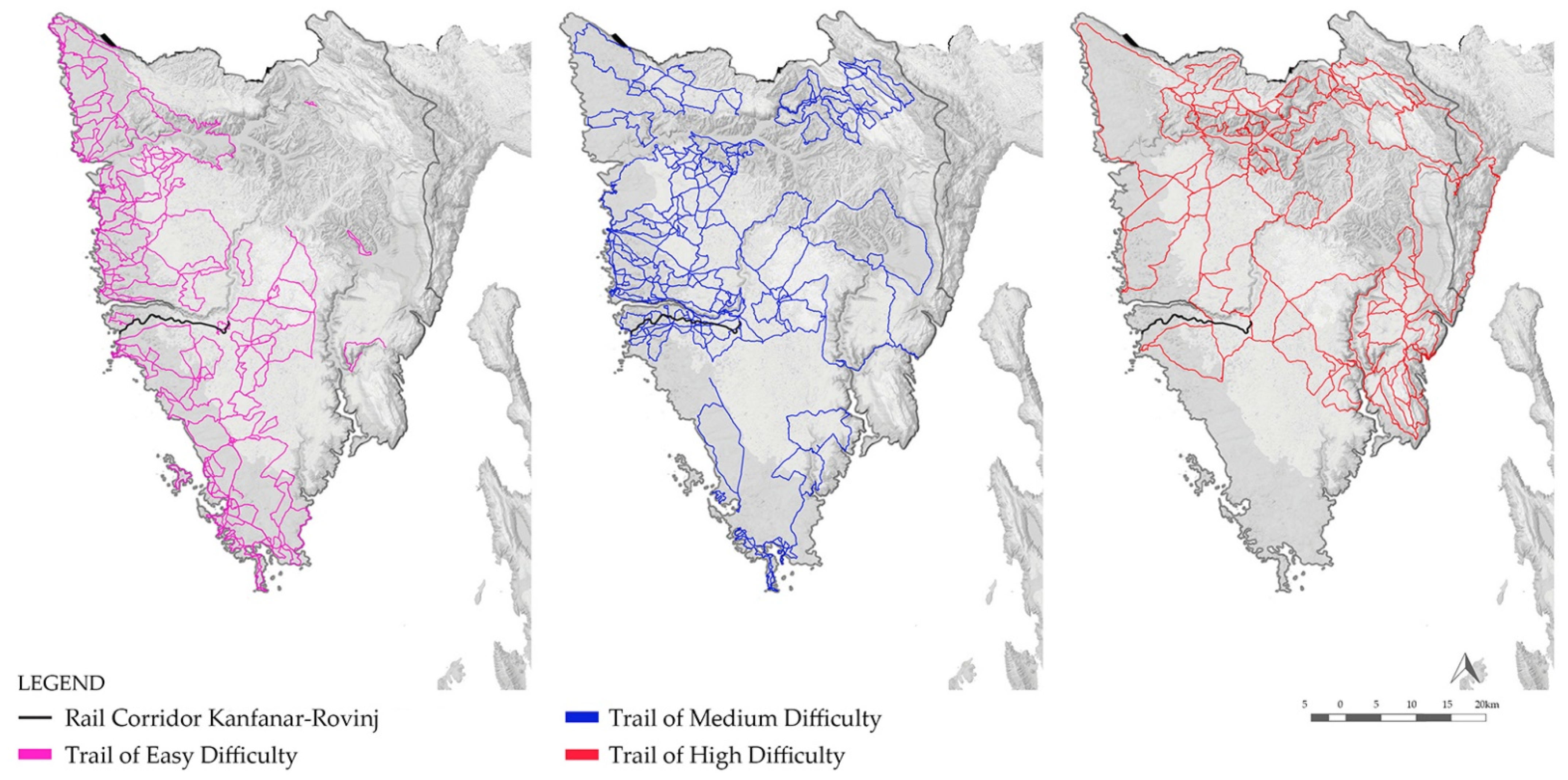
| GPX, SHP, GRD | Bicycle trails | [42] | yes | no |
| Pedestrian trails | [43] | yes | no | |
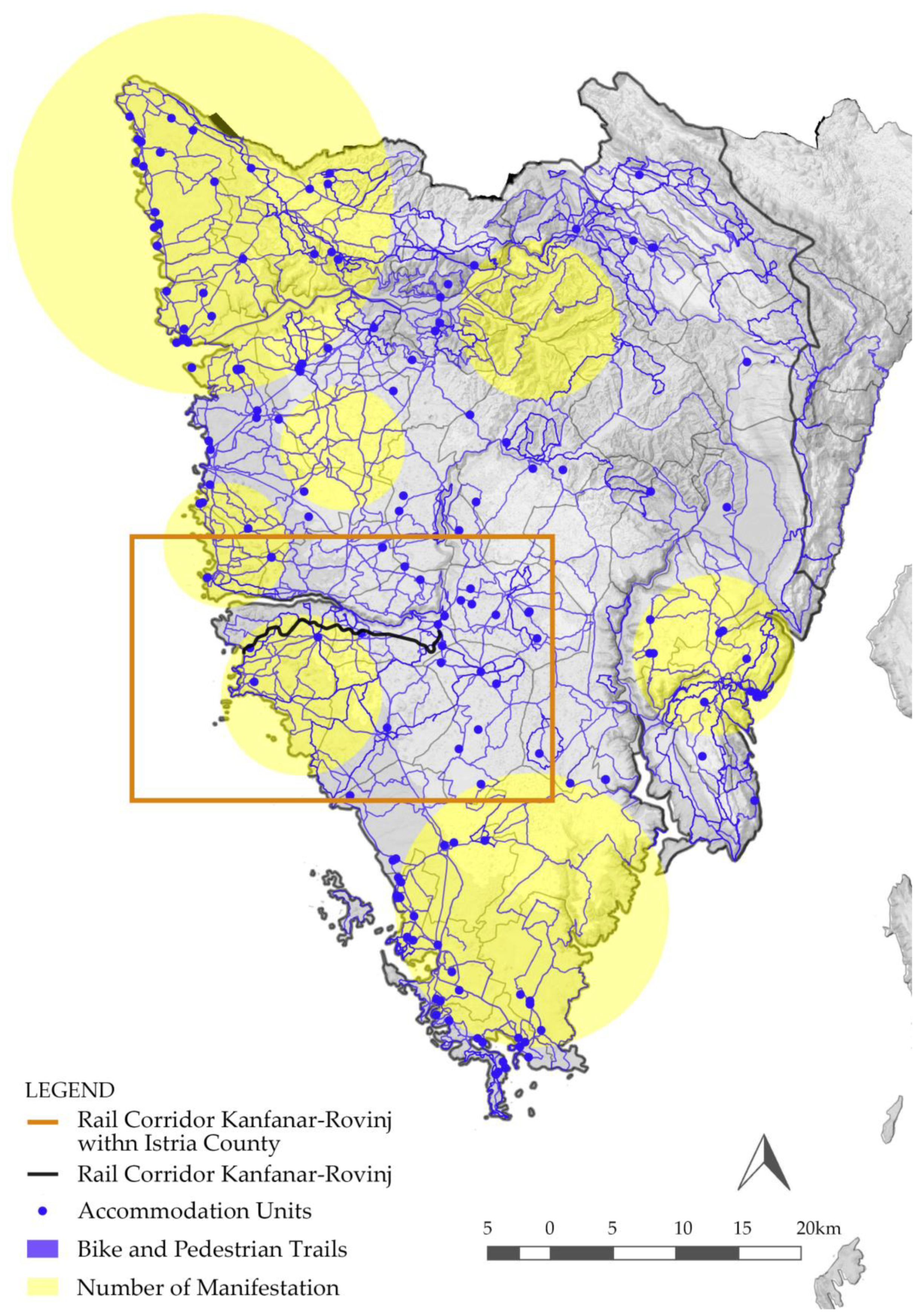
| SHP, GRD | Accomodation units | [42] | no | yes |
| Manifestations | Istria Tourist Board | no | yes | |
| SHP, GRD | Ponds | Invasive Species Centre Institute for Agriculture and Tourism, Poreč | yes | no |
| Land cover | [41] | yes | no | |
| Underground objects open to visitors (pits and caves) | [30] | yes | no | |
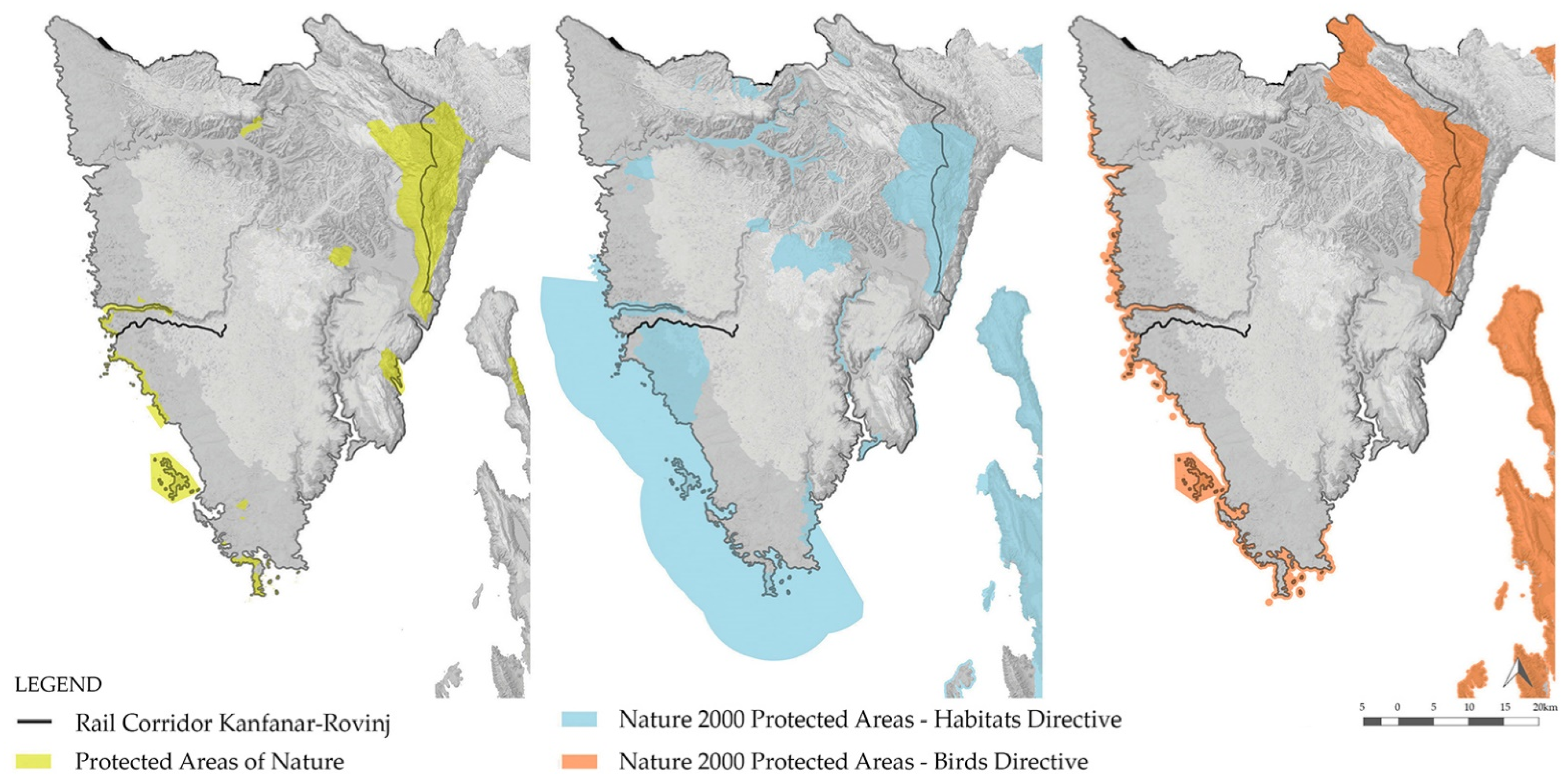
| Protected Areas of Nature, Natura 2000 sites | [30] | yes | no | |
| SHP, GRD | Sources of water | [33,34,35,37,38,39,40] | no | yes |
| SHP, GRD | Cultural heritage | [33,34,35,37,38,39,40] | no | yes |
| SHP, GRD | Lookouts | [17] | no | yes |
| SHP, GRD | Visually attractive areas | [32] | no | yes |
| SHP, GRD | Mariculture | [32] | no | yes |
| SHP, GRD | Unstable geological formations | [41] | yes | no |
| SHP, GRD | Waste | [41] | yes | no |
| SHP, GRD | Flooding areas | Geoportal of Croatian Waters | no | yes |
| SHP, GRD | Drinking water protection zones | [32] | no | yes |
| SHP, GRD | Strategic reserves of underground water | [32] | no | yes |
| SHP, GRD | Pinna nobilis colonies | [30] | yes | no |
| Grasslands | [30] | yes | no | |
| Istrian Y highway | [30] | yes | no | |
| SHP, GRD | Ground prone to erosion (flysch) | [32] | no | yes |
| SHP, GRD | Line of Kanfanar–Rovinj Railway | [6] | no | yes |
| Attractiveness Factors | Distance Value | |||||
|---|---|---|---|---|---|---|
| 1 | 2 | 3 | 4 | 5 | Weight Factor | |
| Ponds | >1000 m | 500–1000 m | 250–500 m | 50–250 m | 0–50 m | |
| Speleological objects | >1000 m | 500–1000 m | 250–500 m | 50–250 m | 0–50 m | |
| Protected areas of nature and the Ecological Network of Natura 2000 | >1000 m | 500–1000 m | 250–500 m | 100–250 m | 0–100 m | |
| Cultural heritage | >500 | 250–500 m | 150–250 m | 50–150 m | 0–50 m | |
| Lookouts | >400 m | 200–400 m | 100–200 m | 50–100 m | 0–50 m | 2 |
| Visually attractive areas | >600 m | 400–600 m | 200–400 m | 100–200 m | 0–100 m | |
| Bicycle and hiking trails | >3500 m | 2000–3500 m | 1000–2000 m | 500–1000 m | 0–500 m | 2 |
| Tourist accommodation | >3500 m | 2000–3500 m | 1000–2000 m | 500–1000 m | 0–500 m | 2 |
| Direct evaluation | ||||||
| Land cover | Industrial or commercial units, Port areas, Mineral extraction sites | Road and rail networks and associated land, Airports | Discontinuous urban fabric, Plough land, Land principally occupied by agriculture, with significant areas of natural vegetation, Traditional woodland shrub | Sport and leisure facilities, Permanently irrigated land | Olive groves, Vineyards, Forests, Sea, Meadows, Pastures, Complex cultivation patterns | |
| Vulnerability Factors | Distance Value | |||||
|---|---|---|---|---|---|---|
| 1 | 2 | 3 | 4 | 5 | Weight Factor | |
| Mariculture | >1000 m | 700–1000 m | 400–700 m | 100–400 m | 0–100 m | |
| Whetstone | >1000 m | 500–1000 m | 300–500 m | 100–300 m | 0–100 m | |
| Landfills | 0–50 m | 50–150 m | 150–250 m | 250–500 m | >500 m | |
| Floodplains (inland) | >600 | 300–600 m | 200–300 m | 100–200 m | 0–100 m | |
| Floodplains (coast side) | >100 m | 90–100 m | 60–90 m | 40–60 m | 0–40 m | |
| Meadows | >100 m | 50–100 m | 30–50 m | 10–30 m | 0–10 m | |
| Colony of Pinna nobilis (pen shell) | >500 m | 250–500 m | 150–250 m | 50–150 m | 0–50 m | |
| Direct evaluation | ||||||
| Sanitary protection zone for drinking water sources | Outside the zone | Restriction zone | Restriction and surveillance zone | Strict restriction zone | – | |
| Strategic groundwater level | – | – | – | – | Entire zone | |
| Highway noise level | 74–79 dB | 69 dB | 64 dB | 59 dB | 54 dB | |
| Soil subject to increased erosion | – | – | Flysch | – | – | |
| Landscape Elements | Natural | Cultural–Historical | Visual–Experiential | |
|---|---|---|---|---|
| Functional Area | Pits | + | + | |
| Kanfanar | Springs | + | + | |
| Lookouts | + | |||
| Abandoned Railway Facilities | + | |||
| Forest Paths | + | |||
| Functional Area | Ponds | + | + | + |
| Kuntrada | Drystone buildings | + | + | |
| Lookouts | + | |||
| Functional Area | Churches | + | + | |
| Rovinj | Lookouts | + | ||
| Forest Paths | + | |||
| Functional Area | Lookouts | + | ||
| Lim Bay | Protected Areas of Nature | + | + | |
| Suitability Value | Protective Aspect Area in % | Development Aspect Area in % | Compromise Aspect Area in % | |
|---|---|---|---|---|
| 1 | Unsuitable | 12% | / | 3% |
| 2 | Marginally suitable | 33% | 6% | 24% |
| 3 | Medium suitability | 32% | 31% | 36% |
| 4 | Very suitable | 23% | 34% | 31% |
| 5 | The most suitable | / | 29% | 6% |
Publisher’s Note: MDPI stays neutral with regard to jurisdictional claims in published maps and institutional affiliations. |
© 2021 by the authors. Licensee MDPI, Basel, Switzerland. This article is an open access article distributed under the terms and conditions of the Creative Commons Attribution (CC BY) license (https://creativecommons.org/licenses/by/4.0/).
Share and Cite
Modesto, A.; Kamenečki, M.; Tomić Reljić, D. Application of Suitability Modeling in Establishing a New Bicycle–Pedestrian Path: The Case of the Abandoned Kanfanar–Rovinj Railway in Istria. Land 2021, 10, 600. https://doi.org/10.3390/land10060600
Modesto A, Kamenečki M, Tomić Reljić D. Application of Suitability Modeling in Establishing a New Bicycle–Pedestrian Path: The Case of the Abandoned Kanfanar–Rovinj Railway in Istria. Land. 2021; 10(6):600. https://doi.org/10.3390/land10060600
Chicago/Turabian StyleModesto, Ariana, Monika Kamenečki, and Dora Tomić Reljić. 2021. "Application of Suitability Modeling in Establishing a New Bicycle–Pedestrian Path: The Case of the Abandoned Kanfanar–Rovinj Railway in Istria" Land 10, no. 6: 600. https://doi.org/10.3390/land10060600
APA StyleModesto, A., Kamenečki, M., & Tomić Reljić, D. (2021). Application of Suitability Modeling in Establishing a New Bicycle–Pedestrian Path: The Case of the Abandoned Kanfanar–Rovinj Railway in Istria. Land, 10(6), 600. https://doi.org/10.3390/land10060600