Article

Forest Area Changes in Cinque Terre National Park in the Last 80 Years. Consequences on Landslides and Forest Fire Risks

Department of Agriculture, Food, Environment and Forestry (DAGRI), University of Florence, Via San Bonaventura 13, 50145 Florence, Italy
*
Author to whom correspondence should be addressed.
Land 2021, 10(3), 293; https://doi.org/10.3390/land10030293
Submission received: 5 February 2021 / Revised: 9 March 2021 / Accepted: 10 March 2021 / Published: 12 March 2021
(This article belongs to the Special Issue Landscape Transformation and Changes in Land Use Intensity)

Abstract

:
Cinque Terre, one of the most important Italian cultural landscapes, has not been spared from depopulation and agricultural abandonment processes, that involved many rural areas in Europe, as a consequence of socio-economic transformations that occurred after WWII. Depopulation of rural areas, especially in mountains or in terraced areas, caused significant environmental consequences, such as the decrease of biodiversity, the landscape homogenization, the increase of hydrogeological and forest fires risks. Cinque Terre National Park (5TNP) was established in 1999, and, differently from other Italian National Parks, not just for protecting natural habitats, but mainly to preserve, restore and valorize the historical terraced landscape. Moreover, the area is a UNESCO cultural landscape site and it is partly protected by three Sites of Community Importance. The research intended to investigate the transformations that have affected forested areas inside the 5TNP in the period 1936–2018, also highlighting the connections with hydrogeological and forest fires risks, as a support for the Park planning strategies and the conservation of the UNESCO site. Results highlighted that 37% of the current forests are the consequence of dry stones terraces abandonment that occurred in the twentieth century, with negative effects on the stability of steep slopes, hydrogeological risk, forest fires and on the conservation of a unique cultural landscape. This confirms the current national trend showing no deforestation occurring, but rather a continuous increase of forests on abandoned land. While 5TNP policies and actions are effectively aimed at pursuing an equilibrium between cultivated areas and forests, the Sites of Community Importance located inside the Park mainly focuses on the conservation of “natural habitats”, even if the current vegetation is also the result of secondary successions on former cultivated land. The research highlighted the need to valorize “cultural values” in forest planning as well as the importance of forest history for an accurate planning of forest resources in protected areas.

1. Introduction

Mediterranean countries are still characterized by a great variety of historical cultural landscapes, as a result of the millenary human presence that has shaped the territory through agro-silvo-pastoral practices [1]. Big socio-economic transformations that have involved Europe in the twentieth century have led to major consequences for the rural world and its landscape [2,3,4,5], consequences that occurred with greater intensity in the Mediterranean basin than in the rest of the continent [6,7,8]. One of the major changes has been the depopulation and the abandonment of rural areas, especially where there were difficulties in cultivation activities, such as in mountain slopes or terraced areas. This process has caused the forests increase in areas previously used for agriculture or as pastures [9], with significant environmental consequences, especially in fragile landscapes and in previously terraced areas [10].
Europe’s forests have expanded in recent decades [11,12], mainly as a result of agricultural areas reduction or abandonment [13]. This trend reflects not only on the total area occupied by forests, but also on the structure of the forest itself [14] and on the structure at landscape level [15]. According to Bebi et al. [16], we can expect important differences between post-agricultural forests compared to areas that have long been forested, while for Camarretta et al. [17] forest structure has significantly changed across Italy over the last 80 years, with the decrease of fragmentation and the enlargement of existing forest patches that have also assumed a more regular shape.
One of the most important Italian cultural landscapes, Cinque Terre, has not been spared from the process of agricultural abandonment and reforestation. The area is characterized by dry-stone terraces on steep slopes for the cultivation of vines and olive trees and is protected by the Cinque Terre National Park (5TNP), established in 1999. Differently from other Italian National Parks, the Cinque Terre NP was also established with the declared purpose of landscape protection and for applying management and restoration strategies aimed at achieving an integration between men and natural environment [18]. Moreover, one of the aims of the National Park, as made clear in the first point of the Art. 3 of the Park Statute, is to “preserve, restore and valorize the historical agricultural landscape” and; therefore, the dry-stone terraces [19].
Cinque Terre traditional landscape attracts thousands of tourists every year, thanks to the terraced cultivations of high aesthetic, historical and cultural value, but in the last years it is facing different threats. As in most of the rural and marginal areas of Italy, Cinque Terre suffered from a significant depopulation and from a crisis of the agricultural sector. In the period 1861–2011, the population decrease in the three main municipalities of the 5TNP (Riomaggiore, Vernazza, Monterosso al Mare) is equal to −35%, while in territory of the municipalities interested by the UNESCO site (an area a little wider than the Park) it has been registered a decrease in the number of farms equal to −76% in the period 1929–2010, and a decrease of the Utilized Agricultural Surface (SAU) equal to −46% in the period 1971–2010 [20,21]. The main consequence of the terraced cultivation abandonment and of newly established woodlands spread is the increase of landslides and erosion. Abandonment of terraces is often followed by pioneer species slope colonization, terrace degradation, hydrogeological hazard and diffuse slope instability [22,23,24,25,26,27].
Planners and managers have to deal with all these vulnerabilities, with a high degree of territory complexity and fragility, that is threatening the overall quality of this unique cultural landscape. Consequently, forest planning in Cinque Terre and in other similar areas has to deal with the fact that forests’ current characteristics in terms of specific composition, typology, vertical and horizontal structure, are mainly the results of secondary successions or of the cessation of a regular forest management, and that they are part of a territory with high risk of hydrogeological problems.
The aim of this research is; therefore, to investigate the transformations that have affected the forested areas inside the 5TNP, also as a support for the future planning of the Park itself. In particular, the research intends to analyze forest area changes and their consequences on the main threats for the cultural landscape of the area: forest fires and landslide risk. The research also intends to answer the following scientific questions: What is the relation between increase of forest surfaces and increase of landslides and forest fires risks? How different types of protected areas are currently dealing with landslides and forest fires risks? Results, in fact, will be discussed according to the National Park statute and regulations, and to the presence of other protected areas of the NATURA 2000 network in order to highlight the coherence of these planning instruments with the changes that affected forests. Documenting the changes that have occurred in the last 80 years in relation to forest fires and landslide risk can help to identify the main vulnerabilities of this fragile territory and, therefore, to properly address strategies and actions for preserving this unique cultural landscape recognizing the positive role of human influence.

2. Materials and Methods
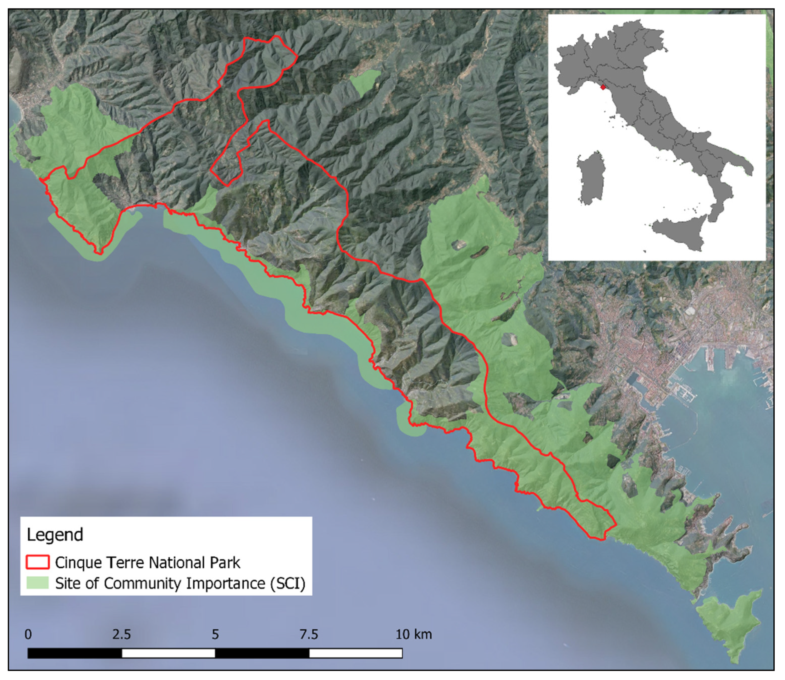
2.1. The Study Area

The study area corresponds to the 5TNP, that lies on the coast of the Liguria Region, in northern Italy (Figure 1). The 5TNP extends for about 3860 ha on a very steep coastline, where the local communities have adapted themselves to this rough and inhospitable territory by building settlements, cultivating land and creating a unique and remarkable cultural landscape. Since the twelfth century, the work of farmers has transformed the slopes into an intensively terraced landscape in order to make it suitable for agricultural activities, mainly for cultivating vines and olive trees, with dry-stone walls densities equal to 3300–6000 m per ha, with a total walls length of about 6700 km [28,29,30]. In this framework, forests have traditionally characterized the highest part of the range, and they have always played a crucial role for hydrogeological protection and water regulation. Unfortunately, since the end of WWII, this territory has facing many challenges, mainly due to the increasing hydrogeological problems caused by terraced cultivations abandonment and the consequent forests expansion.
Due to its unique cultural landscape, Cinque Terre has also been inscribed in the UNESCO World Heritage List, as the area represents “the harmonious interaction between people and nature to produce a landscape of exceptional scenic quality that illustrates a traditional way of life that has existed for a thousand years and continues to play an important socio-economic role in the life of the community” [31]. After the inscription in the WHL, the Cinque Terre National Park (5TNP) was established, in 1999. The two areas do not perfectly overlap, as the National Park is smaller.
According to the Köppen-Geiger climate classification, the area is characterized by a Mediterranean climate (Csa = hot-summer Mediterranean climate) [32], with warm winters and hot summers with frequent periods of drought. The average annual rainfall is equal to 1343 mm, with maximum peaks in autumn and spring. The mountain range runs parallel to the coast and despite the limited altitudes (max altitude 813 m a.s.l., average altitude 346 m a.s.l.), due to the short distance from the sea, it causes a pronounced steepness of the whole territory (average slope of the area 31°) considering that 74% of the total surface has a steepness >25°. The hydrographic network consists of small streams, which frequently cause hydrogeological problems, such as erosion and landslides. According to the Unified Soil Classification System, the soils of the 5TNP mainly belong to GC—clayey gravel and SC—clayey sand classes, subordinately to GM—silty gravel and to SM—silty sand types. In general, local soils present a dominant coarse-grained fraction (gravel and sand), with silt varying between 20.5% and 27.1% in Vernazza and Campiglia, while clay shows values between 14% and 16%, but with particularly lower values in sandy areas such as Campiglia, Manarola and Riomaggiore [33].
Regarding the vegetation types, the steep slopes of the Cinque Terre coast are covered by a high Mediterranean maquis, composed of Quercus ilex and various shrubs species, including Cistus spp., Erica spp. and Arbutus unedo. Terrains with a higher level of aridity and rockiness are characterized by a low maquis, with the presence of aromatic species such as rosemary, thyme, helichrysum and lavender. The caper, which grows in the recesses of dry stone walls, is the remnant of cultivations of the last century. At higher altitudes there are pine forests of anthropic origin and forests, with prevalence of chestnuts in the side valleys characterized by higher humidity levels. Among the main tree species there are three oaks which were once important for the local economy for the production of both firewood and acorns: Quercus cerris, Q. suber and Q. pubescens.

2.2. Methodology

The research is based on the comparison of the forested areas in 1936 and 2018, through the analysis of two digitalized cartographies: the Forest Map of the Kingdom of Italy of 1936 and the official Land Use Map of 2018 of Liguria Region. All the elaborations and analysis were carried out through the use of the software QGIS 3.4.13, with the help of GRASS plug-in.
The Forest Map of the Kingdom of Italy of 1936 was recently digitized and made available by the Italian Forestry Service both in raster, as the result from the scanning and georeferencing of the original sheets, and in vector format. The latter was the one used for this research, while the original 1936 Forest Map was made of 276 sheets at 1:100,000 scale. The information contained in the document covers the entire Italian territory in 1936; therefore, it was cut according to the 5TNP boundaries. The map describes forests according to different classes mainly based on a wood production perspective, identifying different physiognomic categories, with sub-categories related to the form of government or, in the case of resinous trees, to the presence of different species, but it does not include information about non-forest land uses. Among the original categories, the one called “degraded woods” does not have a clear definition, and it can refer to different types of forests, such as the Mediterranean maquis, or areas degraded by fires or by overgrazing, or shrublands which could be candidates for reforestation [34]. The 2018 Land Use Map (1:10,000 scale) is the more recent and detailed official document of Liguria Region regarding land cover and land use. It is not specifically made for forests and, unfortunately, the legend used for forests does not contain information about the different forest management types, as coppice or high-stand, and it is mainly based on physiognomic vegetation types.
The choice of these documents comes mostly from the availability of geo-referenced cartographic material with detailed information about forests. The 1936 forest map was used as basis for all the elaborations, as it is the older available document with indications concerning the spatial distribution of forests in vector format. The 2018 Land Use was chosen because it represents the most recent official document with detailed spatial information and, therefore, it can be compared to the one of 1936. To make it comparable with the 1936 forest types, some forest types of 2018 were merged together (e.g., “mixed thermophile forest” and “mixed mesophile forest” were merged into “mixed broadleaved forest”). Despite the difference in the maps scales, it was possible to compare them as the 1936 Forest Map is particularly accurate (Table 1).
The comparative analysis of the two historical periods made it possible to classify the forest areas in three macro-categories:
  • Woodlands present in 1936: All the forest areas of 2018 that were already covered by woods in 1936;
  • Woodlands of new growth: All the forest areas of 2018 that in 1936 were designed for other uses, such as agriculture and pastures and; therefore, corresponds to the territories in which forests expanded in the period 1936–2018;
  • Lost woodlands: All the non-forest areas of 2018 that in 1936 were instead covered by forests, corresponding to the areas from which forests have been removed.
Elevation data results from the Digital Terrain Model of the Liguria Region with a resolution equal to 5 m. Boundaries of the Cinque Terre National Park and of the three Sites of Community Importance are the official ones, as they were downloaded as shapefiles from the website of the Italian Ministry of Environment.
After the analysis of the forest dynamics, a survey on the two main threats for the area was conducted. These correspond to forest fires and hydrogeological risk. Spatial data about these issues were downloaded from the official repository of the Italian Ministry of Environment and they were overlaid with the forest area changes map and analyzed with the help of the software QGIS 3.4.13 with GRASS plug-in. The analysis consisted of the geographical overlap of the three layers, and of the elaboration of the percentage of the three forest area changes classes according to the different official risks categories.
Finally, the roles of the 5TNP and of the three SICs were investigated, in order to highlight opportunities and limitations for future forest planning, since the National Park is actually without an approved Management Plan.

3. Results

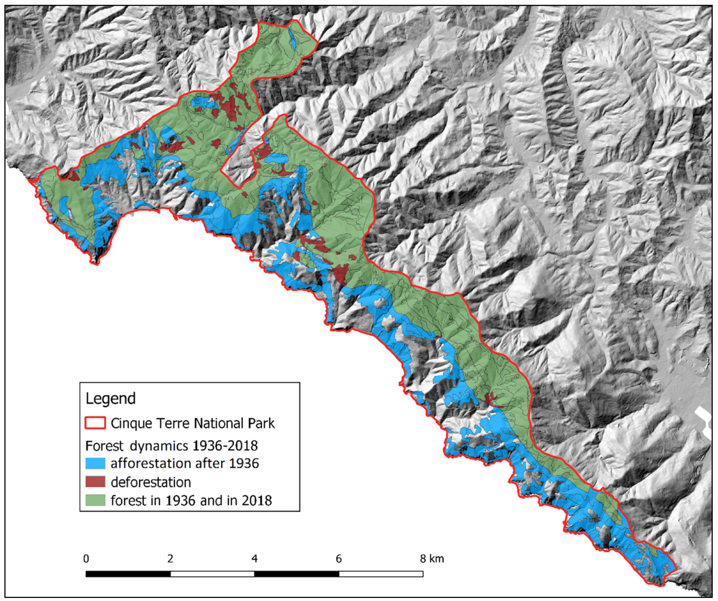
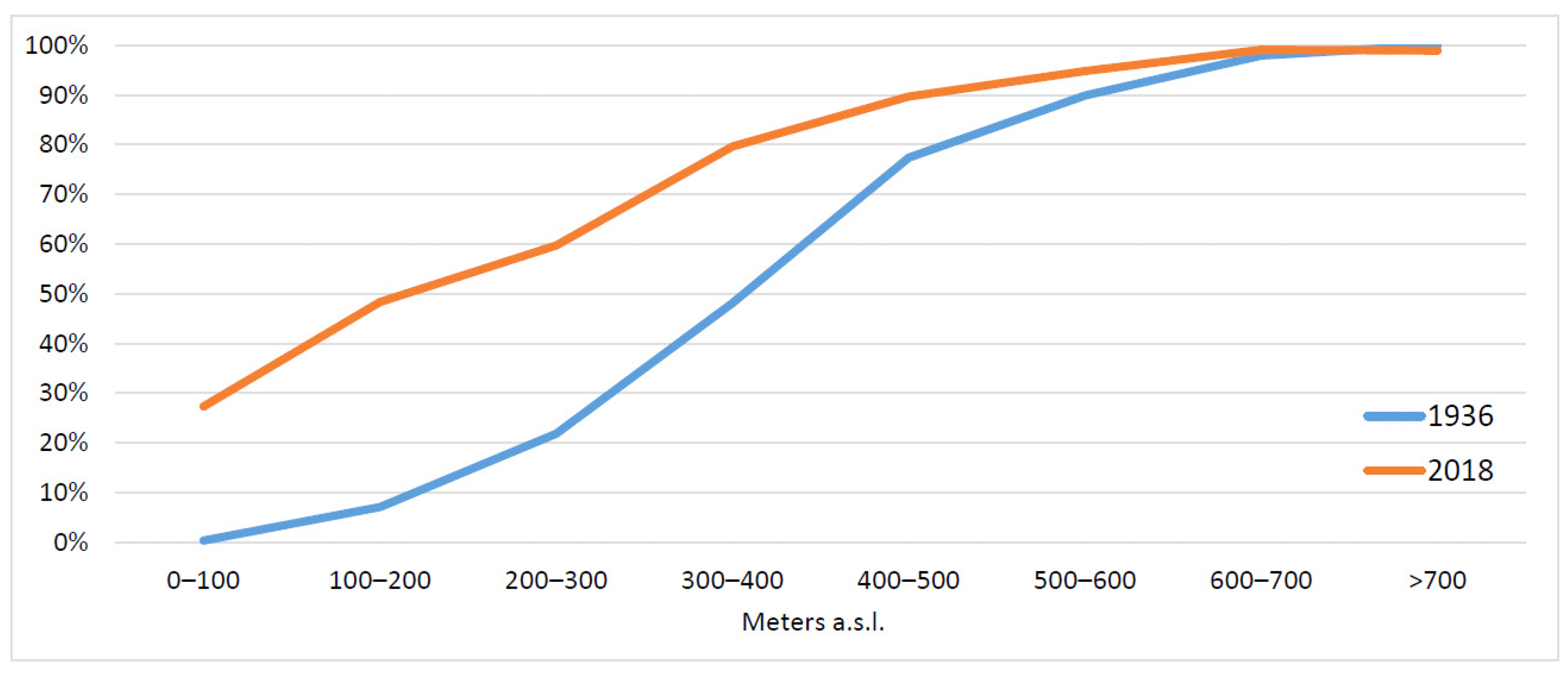
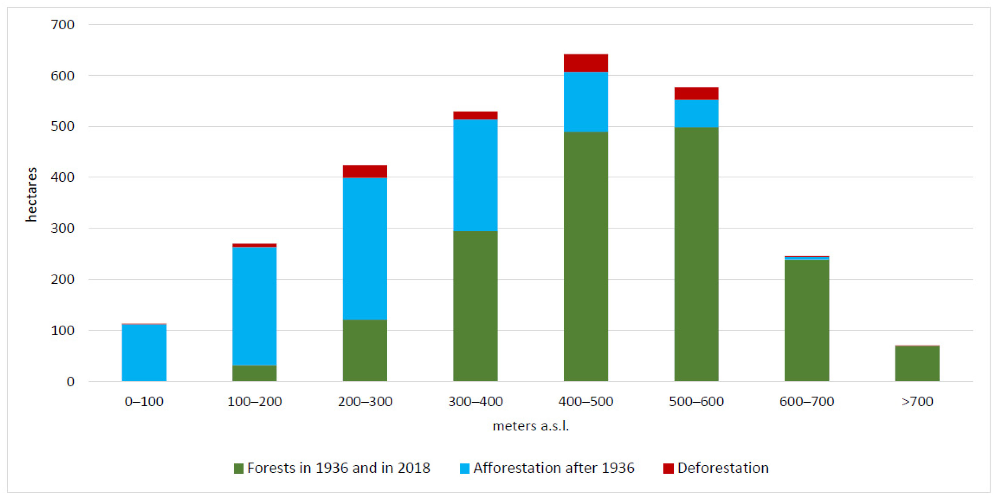
3.1. The Transformation of the Forested Areas in the Period 1936–2018

The first data that is possible to compare is the total forested area. In 1936, forests occupied 1857 ha, while in 2018 they can be found on 2763 ha. This means that in 82 years, forests significantly increased their area, at a rate of about 11 ha/year.
In 1936, most of the forests (Table 2) were classified as pine forests (72.4%), followed by mixed broadleaved coppice forests (13.1%) and by chestnut forests (12.4%). Chestnut forests were managed both as coppice and as high stand forest, as they could provide different products.
In 2018, the official Land Use Map of the Liguria Region identified nine different vegetational typologies for the area of the National Park (Table 3). The most widespread is the pine forest (64.9%), that in reality corresponds to forests with prevalence of pine but also with a significative lower layer of broadleaved species, and of species typical of the Mediterranean maquis, such as Quercus ilex, Arbutus unedo and Erica spp. In fact, the Pinus pinaster trees that were so common in the area are currently dying due to an infection of Matsucoccus feytaudi [35]. This forest typology is followed by Sclerophyll vegetation and Mediterranean maquis (20.7%), forests with prevalence of chestnuts (18.4%) and by mixed forests of conifer and broadleaved (17.5%). The presence of shrublands and of forests and shrublands in evolution is the evidence of ongoing phenomena of secondary succession due to recently abandoned terraced cultivations.
The comparison between 1936 and 2018 highlighted the increase of forest areas, with 1022 ha of new forests on lands that in 1936 were not classified as woodlands. On the other hand, about 1747 ha of forests in 1936 are still forests, while deforestation occurred only on 111 ha. Figure 2 shows that new forested areas are the results of colonization processes started from higher altitudes. Probably, the cultivated areas located at the border with the forests were the first to be abandoned, as they were further away from the settlements and from the main roads and paths, so that forest has descended towards lower altitudes. Actually, the rest of the area is mainly occupied by cultivations of olive trees and vines on dry-stone terraces, followed by rocky outcrops and by anthropic areas (buildings, roads, railway).
This is also confirmed by forests distribution analysis according to altitudinal ranges. The 73% of 1936 forested areas were located at altitudes above 400 m a.s.l., near the top of the range that runs parallel to the coast, and they were crucial for preserving the cultivations on terraces located at lower altitudes from hydrogeological problems, while 24% of forests were instead located in the range 200–400 m a.s.l. In 2018, only 53% of forests are located above 400 m a.s.l. and 33% are found between 200 and 400 m a.s.l., clearly highlighting how forests “moved” towards lower altitudes (Figure 3).
In fact, 48.9% of the forest areas developed after 1936 are mainly found in the range 200–400 m a.s.l., 33.8% below 200 m a.s.l., and 17.3% above 400 m a.s.l. (Figure 4). It is also important to notice that in 1936 forests were not very widespread below 300 m a.s.l., as that altitudinal range was mainly used for agricultural activities as it was close to the villages and to communication routes.
An analysis of forest areas distribution according to slope has also been carried out, but it has not highlighted specific correlation between the two. The only result is that forests are more frequent (both in 1936 and in 2018) in steeper areas, due to the fact that these ones are less suitable for agricultural activities.
Table 4 summarizes the main changes according to the main forest types. The most widespread dynamics affects pine forests. These forests were the most widespread in 1936 and also in 2018, but significant changes occurred: only 54% of 1963 pine forests are classified in the same way in 2018, while 11.6% have become mixed forests, 10.3% forests with prevalence of chestnuts and 9.7% xerophilous forest with evergreen vegetation. This means that pine forests underwent significant ecological successions with the progressive entry of local broadleaved species. At the same time, 43.7% of pine forests of 2018 are the result of secondary successions, mainly on areas that in 1936 were not occupied by forests (31% of the 2018 pine forests). The forest typologies that mostly expanded on areas once used for cultivations or pastures are in fact pine forests (373.6 ha) followed by Sclerophyll vegetation-Mediterranean maquis (320.5 ha), corresponding to the typologies characterized by the presence of pioneer species, as Mediterranean pines, or species typical of the maquis, as Quercus ilex, Cytisus spp., Phillyrea spp., Arbutus unedo, Erica spp.

3.2. Forest Fires and Hydrogeological Risk in Cinque Terre National Park

Forest fires represent a major cause of vulnerability for the cultural landscape of Cinque Terre and especially for their forests. According to the fire statistics for the period 1987–2015 of the municipalities of Riomaggiore, Vernazza and Monterosso (that represent the 87% of the surface of the 5TNP), a total of 134 forest fires on a total area of 707.98 ha occurred. The main causes identified are: voluntary and malicious causes (79%), unintended causes (14%), unknown causes (5%) and natural causes (2%) [36]. According to the summer forest fires risk classification, 22.9% of the 5TNP surface is classified as Risk 1— areas characterized by infrequent and/or very low intensity fires (mainly involving the herbaceous layer), 43.6% as Risk 2—areas characterized by infrequent and low intensity fires, 33.1% as Risk 3—areas characterized by medium intensity fires (mainly involving the shrub layer) and 0.4% as Risk 4—areas characterized by medium-high intensity fires (mainly involving the shrub layer with high propagation speed).
According to hydrogeological risk data provided by the Italian Institute for Environmental Protection and Research (ISPRA), and made available through the National Geoportal of the Ministry of Environment, 28.9% of the territory of the 5TNP is considered at landslide risk. Of these 1119.5 ha, ]4.1% is classified as at very high risk, 6.4% at high risk, 15.5% at medium risk and 74.1% at moderate risk.
Table 5 summarizes the overlay of these two risks with the forest dynamics in the period 1936–2019. Regarding forest fires, no big differences about the susceptibility to forest fires between new forests and areas occupied by forests already in 1936 result highlighted, even if the 37.8% of new forests are in classes 3 and 4, while a lower percentage (34.5%) of forests of 1936 is classified in the same classes. Anyway, this does not mean that forest fire risk is not increased in the last years. Even if the new forest areas do not have a higher forest fires risk itself, it is evident that, due to the fact that there are about 1022 ha of new forests, the overall forest fire risk for the 5TNP is considerably higher. For what concerns the landslide risk, instead, it is evident that new forests have a higher risk. A total of 95.3% of surfaces that were already forests in 1936 fall into the “no risk” class, against 68.7% of the forest areas developed after 1936. In addition, 24.7% of new forests are in the lower risk classes (moderate, medium) and 6.6% in the higher classes (high, very high), while for territories that were already forests in 1936, these percentages are 4.7% and 0%, respectively.

3.3. The Role of the National Park and of the Sites of Community Importance

5TNP is currently without an approved Management Plan, therefore, it is important to provide data and ideas to support the future planning of the Park. The main official document of the NP, serving as guidelines, is the Statute of the Park, approved in 2011 [19], especially the Article 3 that clarifies the Park aims. The first aims are the “conservation, restoration and valorization of the historical landscape of the Cinque Terre”, while there is no specific mention of forests in the list. There is instead the need to “promote the integration of man and natural environment through the preservation of anthropologic, archeologic, historic and architectonic values and of agro-silvo-pastoral activities”. The 5TNP has been, in fact, specifically created to preserve the unique cultural landscape made of terraced cultivations of vines and olive trees on steep slopes. In this context, forests have an important role for water regulation and hydrogeological protection, especially as they always have been located on the highest part of the range, protecting the cultivations at lower altitude. As shown by the results, the expansion of forests in the last 82 years has been particularly significative and this has contributed to the worsening of the hydrogeological risk and to the increase of landslides and erosion phenomena.
Beside the 5TNP, the area includes also three different Sites of Community Importance (SCI), part of the Natura 2000 network, all proposed in 1995: the SCI Costa Riomaggiore-Monterosso (IT1344323) extends for about 163 ha completely inside the Park, the SCI Punta Mesco (IT1344210) has a surface of 325 ha lying inside the Park boundaries, and the SCI Portovenere-Riomaggiore-S. Benedetto (IT1345005) falls for about 517 ha inside the Park. Therefore, about the 26% of the 5TNP area is part of the Natura 2000 network.
According to the official data forms of the three SCIs, the following is the list of the forest habitat types present in the sites:
  • 91AA—Eastern white oak woods
  • 91E0—Alluvial forests with Alnus glutinosa and Fraxinus excelsior (Alno-Padion, Alnion incanae, Salicion albae)
  • 9260—Castanea sativa woods
  • 9330—Quercus suber forests
  • 9340—Quercus ilex and Quercus rotundifolia forests
  • 9540—Mediterranean pine forests with endemic Mesogean pines
The overlapping of the SCIs boundaries with the forest changes, in the period 1936–2018, showed that the 48.8% of the surface included in the SCIs corresponds to new forests developed after 1936, while only 28.5% of the surface corresponds to areas that were already forests in 1936. Moreover, it is necessary to consider that, of this 286.4 ha of area that was already forest in 1936, 156.9 ha was managed as coppices in 1936. Therefore, most of the forest habitats protected by the SICs are just the consequence of the abandonment of agricultural activities or of a regular forest management. For these reasons, it is possible to state that these forests have a clear cultural origin and their environmental value is reduced. The only relevant forest habitat of the area is the 9330-Quercus suber forests, as this species is quite rare in the area and is close to the northern limit of its areal.

4. Discussion

The abandonment of cultural landscapes is frequently confused with “re-wilding” or “re-naturing”, with negative effects on biodiversity, habitats, hydrogeological protection and food production. The desire for wilder future landscapes [37,38,39] also comes to the fact that most of the population in Italy, as well as in other European countries, currently live in the cities, with no connection with rural life. Agro-silvo-pastoral activities are no more part of their cultural background and rural areas are always more often perceived as “natural spaces” in opposition to “anthropic spaces”, as the integration between rural areas and settlements is almost lost.
As shown by the results, the expansion of forests in the last 82 years has been particularly significative, considering that the 37% of actual forest area is the direct consequence of agricultural abandonment. The fact that forests grown after 1936 occupies 26.4% of the surface of the NP has not only impacted the preservation of a unique cultural landscape, but has also important consequences on the environment and on the planning of the area. Results have in fact highlighted the increase of territory portions exposed to forest fire risk and that forests grown after 1936 are significantly less stable from the hydrogeological point of view. As demonstrated by different studies, the abandonment of terraced cultivation and the consequent colonization by shrubs and trees causes a great and diffuse instability of the slopes. Previous studies conducted in Cinque Terre highlighted a correlation between the abandonment of terraced cultivation and the landslides that occurred on 25 October 2011, when heavy rains with peaks of 111 mm/h and 350 mm/6h caused loss of lives, landslides and damages to structures and to economic activities [40]. A research on the detachments of the landslides after this event found that 45% of detachments occurred in areas occupied by forests or shrublands, 47% occurred in recently abandoned terraces and only 6% on cultivated terraces [41], confirming that recently abandoned terraces are particularly subject to hydrogeological risk [42,43]. Regarding forest fires, the fact that from 2002, with the beginning of forest fires prevention activities carried out by the National Forest Service in 5TNP, forest fires decreased significantly, both in terms of average surface and number of fires [36], is a common trend in Italy observed from the 1990s [44]. This is mainly due to more efficient forest fires prevention and fight, but it also means higher costs for these activities in the financial statements of public entities in charge of these activities. The problem is well-known to the 5TNP administration, whereby the Fire Prevention Plan 2015–2019 identified the reduction of fuel load through direct silvicultural interventions, the farms support to recover terraced cultivations, favoring forestry utilizations and improving the hiking network and the accessibility as the main priorities in relation to forest fires prevention [36].
As demonstrated for a variety of environmental situation, the spread of forest areas and the consequent landscape homogenization can lead to a decrease of microhabitats variety, also represented by dry-stone walls network and, therefore, to a decrease of biodiversity [45,46,47].
The local population, especially farmers, perceive the abandonment of terraced cultivations, and the consequent reforestation and hydrogeological risk, as the main factors threatening the identity of the place [48]. Regarding this, it is necessary to highlight that in the last years there has been a slow but perceptible return by some young people to agricultural activities, together with the spread of local associations of citizens who are involved in restoring dry-stone walls, removing shrubs from abandoned terraces and turning them back into cultivated areas.
The main limitation of this research is due to the fact that being based on datasets from different sources is subject to technical problems; however, this is common and well-known for analysis of land-use/land-cover change [49]. Despite this, results of our survey are coherent with similar studies. Santoro et al. [48] report for the UNESCO area (that is bigger than the 5TNP) an increase of woodlands and shrubland from 55% to 77% in the period 1973–2010. It is, in fact, recognized that, in the last decades, a significant reforestation trend is affecting European rural areas, mainly in Mediterranean countries [50,51,52], as a consequence of natural and human driven processes [53]. The same trend is particularly common in Italy, especially in mountainous areas [54,55] as well as in protected areas [56,57,58,59].
In 5TNP, the abandonment of terraced cultivations reached higher rates after WWII and it is; therefore, not even possible to think of restoring all the abandoned dry-stone terraces, but it is necessary to address the planning of the territory towards an equilibrium between forests and cultivations. The abandonment of agro-pastoral activities, and in general land use changes, are in fact recognized as the major driving forces affecting forest dynamics in Mediterranean mountains [60], also inside Natura 2000 protected areas [61]. Therefore, disclosing the effects of past human activities and the evolution of forest areas become crucial for forest managers to assess future vegetation dynamics [62].

5. Conclusions

According to the results of the study, the role of the 5TNP can be crucial for the preservation of the cultural landscape, also because it represents the main aim of the Park itself, and for the reduction of the hydrogeological risk. The activities carried out in the last years by the 5TNP seem to be coherent with the aims. Among these, there are the participation to the LIFE project Prosit-Planning and restoring of Cinque Terre costal traditional agricultural landscape (LIFE00 ENV/IT/000191), the support to smallholder farmers providing free stones for terraces restoration and the publication of the “Manual for the construction of dry-stone walls. Guidelines for the maintenance of the terraces of the Cinque Terre”. On the other side, the role of the SCIs seems not appropriate for preserving the features of this cultural landscape. Despite the fact that, in the description of the sites’ characteristics included in the official data forms, the presence of “intensively cultivated terraced vineyards that represent important features for the landscape and the biodiversity” is highlighted, the focus of the SCIs is on “natural” values rather than on the “cultural” ones.
The research has demonstrated that the future of the Cinque Terre cultural landscape is strictly connected to the need of integrating “cultural values” in local forest planning, as suggested by the MCPFE Vienna Resolution for Sustainable Forest Management [63]. Local forests can have a relevant role in relation to hydrogeological risk and water regulation or to forest fires prevention, but only if they are properly managed. In fact, the new forest areas on abandoned terraces represent a risk factor in relation to slopes stability. The aims listed in the 5TNP Statute must represent the fundamental principles to be followed for an accurate planning of the area that needs to be the focus of the new Management Plan, while the presence of the SICs can constitute a threat, especially as they could wrongly emphasize the “natural” features of the area leading to a total conservation.
Considering the importance recognized to Cinque Terre as one of the most famous and well-known touristic destinations in Italy, due to the “natural” beauty which is effectively a direct result of a series of landscape transformations consequent to man and nature coadaptation processes, it results fundamental from a landscape and environment conservation and planning point of view, to consider the cultural background that has contributed to the current landscape creation. The forest component as well as the agricultural and urban ones are fundamental for the maintenance of local and traditional landscape features, environment protection and touristic enjoyment. Nevertheless, it is important to analyze forest transformation dynamics and its composition in order to better implement planning and management tools that have a focus on landscape, environment and biodiversity conservation. Regarding this, the research demonstrated the importance of forest history studies for an accurate planning of forest resources, especially in protected areas and in cultural landscapes.

Author Contributions

Conceptualization, A.S., M.V. and F.P.; methodology, A.S., M.V. and F.P.; software, A.S. and F.P.; supervision, A.S. and M.A.; writing—original draft, A.S., M.V., F.P., B.F., F.C. and M.A. All authors have read and agreed to the published version of the manuscript.

Funding

This research received no external funding.

Data Availability Statement

The data presented in this study are available on request from the corresponding author.

Conflicts of Interest

The authors declare no conflict of interest.

References

  1. Vos, W.; Meekes, H. Trends in European cultural landscape development: Perspectives for a sustainable future. Landsc. Urban Plan. 1999, 46, 3–14. [Google Scholar] [CrossRef]
  2. Plieninger, T.; Draux, H.; Fagerholm, N.; Bieling, C.; Bürgi, M.; Kizos, T.; Verburg, P.H. The driving forces of landscape change in Europe: A systematic review of the evidence. Land Use Policy 2016, 57, 204–214. [Google Scholar] [CrossRef] [Green Version]
  3. García-Martín, M.; Quintas-Soriano, C.; Torralba, M.; Wolpert, F.; Plieninger, T. Landscape Change in Europe. In Sustainable Land Management in a European Context. Co-Design Approach; Weith, T., Barkmann, T., Gaasch, N., Rogga, S., Strauß, C., Zscheischler, J., Eds.; Springer: Cham, Switzerland, 2020; pp. 17–37. [Google Scholar]
  4. Jongman, R.H.G. Homogenisation and fragmentation of the European landscape: Ecological consequences and solutions. Landsc. Urban Plan. 2002, 58, 211–221. [Google Scholar] [CrossRef]
  5. Palang, H.; Mander, U.; Aarne, L. Landscape diversity changes in Estonia. Landsc. Urban Plan. 1998, 41, 163–169. [Google Scholar] [CrossRef]
  6. Kizos, T.; Koulouri, M. Agricultural landscape dynamics in the Mediterranean: Lesvos (Greece) case study using evidence from the last three centuries. Environ. Sci. Policy 2006, 9, 330–342. [Google Scholar] [CrossRef]
  7. Wolpert, F.; Quintas-Soriano, C.; Plieninger, T. Exploring land-use histories of tree-crop landscapes: A cross-site comparison in the Mediterranean Basin. Sustain. Sci. 2020, 15, 1267–1283. [Google Scholar] [CrossRef]
  8. Debolini, M.; Marraccini, E.; Dubeuf, J.P.; Geijzendorffer, I.R.; Guerra, C.; Simon, M.; Targetti, S.; Napoléone, C. Land and farming system dynamics and their drivers in the Mediterranean Basin. Land Use Policy 2018, 75, 702–710. [Google Scholar] [CrossRef]
  9. Loran, C.; Munteanu, C.; Verburg, P.H.; Schmatz, D.R.; Bürgi, M.; Zimmermann, N.E. Long-term change in drivers of forest cover expansion: An analysis for Switzerland (1850–2000). Reg. Environ. Chang. 2017, 17, 2223–2235. [Google Scholar] [CrossRef]
  10. Agnoletti, M.; Santoro, A. Cultural values and sustainable forest management: The case of Europe. J. For. Res. 2015, 20, 438–444. [Google Scholar] [CrossRef]
  11. Senf, C.; Seidl, R. Mapping the forest disturbance regimes of Europe. Nat. Sustain. 2021, 4, 63–70. [Google Scholar] [CrossRef]
  12. Fuchs, R.; Herold, M.; Verburg, P.H.; Clevers, J.G.P.W.; Eberle, J. Gross changes in reconstructions of historic land cover/use for Europe between 1900 and 2010. Glob. Chang. Biol. 2015, 21, 299–313. [Google Scholar] [CrossRef]
  13. Krajewski, P.; Solecka, I.; Mrozik, K. Forest landscape change and preliminary study on its driving forces in Ślęża Landscape Park (Southwestern Poland) in 1883–2013. Sustainability 2018, 10, 4526. [Google Scholar] [CrossRef] [Green Version]
  14. Gellrich, M.; Baur, P.; Koch, B.; Zimmermann, N.E. Agricultural land abandonment and natural forest re-growth in the Swiss mountains: A spatially explicit economic analysis. Agric. Ecosyst. Environ. 2007, 118, 93–108. [Google Scholar] [CrossRef]
  15. Palmero-Iniesta, M.; Espelta, J.M.; Gordillo, J.; Pino, J. Changes in forest landscape patterns resulting from recent afforestation in Europe (1990–2012): Defragmentation of pre-existing forest versus new patch proliferation. Ann. For. Sci. 2020, 77, 1–15. [Google Scholar] [CrossRef]
  16. Bebi, P.; Seidl, R.; Motta, R.; Fuhr, M.; Firm, D.; Krumm, F.; Kulakowski, D. Changes of forest cover and disturbance regimes in the mountain forests of the Alps. For. Ecol. Manag. 2017, 388, 43–56. [Google Scholar] [CrossRef] [PubMed] [Green Version]
  17. Camarretta, N.; Puletti, N.; Chiavetta, U.; Corona, P. Quantitative changes of forest landscapes over the last century across Italy. Plant Biosyst. Int. J. Deal. Asp. Plant Biol. 2018, 152, 1011–1019. [Google Scholar] [CrossRef]
  18. Decreto del Presidente della Repubblica. Istituzione del Parco Nazionale delle Cinque Terre. Gazzetta Ufficiale della Repubblica Italiana del 17.12.1999. Available online: https://www.gazzettaufficiale.it/atto/serie_generale/caricaDettaglioAtto/originario?atto.dataPubblicazioneGazzetta=1999-12-17&atto.codiceRedazionale=99A10702&elenco30giorni=false (accessed on 9 March 2021).
  19. Ente Parco Nazionale delle Cinque Terre. Statuto del Parco Nazionale delle Cinque Terre. Approvato con Deliberazione n. 042 del 08.06.2011. Available online: www.parconazionale5terre.it/pdf/DeliberaStatuto42_2011.pdf (accessed on 22 January 2021).
  20. ISTAT. Censimento Generale dell’Agricoltura 2010; ISTAT: Rome, Italy, 2010. [Google Scholar]
  21. Istituto Centrale di Statistica del Regno d’Italia. Catasto Agrario 1929; Istituto Poligrafico dello Stato: Rome, Italy, 1934. [Google Scholar]
  22. Cerda, A.; Rodrigo-Comino, J.; Novara, A.; Brevik, E.C.; Vaezi, A.R.; Pulido, M.; Giménez-Morera, A.; Keesstra, S.D. Long-term impact of rainfed agricultural land abandonment on soil erosion in the Western Mediterranean basin. Prog. Phys. Geogr. Earth Environ. 2018, 42, 202–219. [Google Scholar] [CrossRef]
  23. Brancucci, G.; Masetti, M. Terraced Systems: Heritage and Risk. In Terraced Landscapes of the Alps: Atlas; Scaramellini, G., Varotto, M., Eds.; Marsilio: Venice, Italy, 2008; pp. 46–53. [Google Scholar]
  24. Harden, C. Interrelationships between abandonment and land degradation: A case from the Ecuadorian Andes. Mt. Res. Dev. 1996, 16, 274–280. [Google Scholar] [CrossRef]
  25. Lasanta, T.; García-Ruiz, J.M.; Pérez Rontomé, M.C.; Sancho, C. Runoff and sediment yield in a semi-arid environment: The effect of land management after farmland abandonment. Catena 2000, 38, 265–278. [Google Scholar] [CrossRef] [Green Version]
  26. Khanal, N.; Watanabe, T. Abandonment of agricultural land and its consequences. Mt. Res. Dev. 2006, 26, 32–40. [Google Scholar] [CrossRef] [Green Version]
  27. Sanchez-Maranon, M.; Soriano, M.; Delgado, G.; Delgado, R. Soil quality in Mediterranean mountain environments. Effects of land use change. Soil Sci. Soc. Am. J. 2002, 66, 948–958. [Google Scholar]
  28. Compagnoni, C. Biblioteca Storica di Diodoro Siculo Tomo Secondo; Tipografia di Gian Battista Sonzogno: Milan, Italy, 1820. [Google Scholar]
  29. Marmocchi, F.C. Descrizione dell’Italia; Poligrafica Italiana: Florence, Italy, 1846. [Google Scholar]
  30. Terranova, R. Il Paesaggio Costiero Terrazzato delle Cinque Terre in Liguria. Studi Ric. Geogr. 1989, XII, 1–58. [Google Scholar]
  31. UNESCO. Advisory Board Evaluation; UNESCO: Paris, France, 1998. [Google Scholar]
  32. Kottek, M.; Grieser, J.; Beck, C.; Rudolf, B.; Rubel, F. World Map of the Köppen-Geiger climate classification updated. Meteorol Z 2006, 15, 259–263. [Google Scholar] [CrossRef]
  33. Terranova, R.; Zanzucchi, G.; Bernini, M.; Brandolini, P.; Campobasso, S.; Faccini, F.; Zanzucchi, F. Geologia, geomorfologia e vini del parco Nazionale delle Cinque Terre (Liguria, Italia). Boll. Soc. Geol. Ital. Spec. 2006, 6, 115–128. [Google Scholar]
  34. Puddu, G. Le Trasformazioni del Paesaggio Viste Attraverso la Cartografia Storica: Il Caso Della Regione Sardegna; Università Degli Studi Della Tuscia: Viterbo, Italy, 2010. [Google Scholar]
  35. Turcato, C.; Paoli, C.; Scopesi, C.; Montagnani, C.; Mariotti, M.G.; Vassallo, P. Matsucoccus bast scale in Pinus pinaster forests: A comparison of two systems by means of emergy analysis. J. Clean. Prod. 2015, 96, 539–548. [Google Scholar] [CrossRef]
  36. Parco Nazionale delle Cinque Terre. Piano di Previsione, Prevenzione e Lotta Attiva Contro Gli Incendi Boschivi. Periodo 2015–2019. Ministero dell’Ambiente e della Tutela del Territorio e del Mare. Available online: www.minambiente.it/sites/default/files/archivio/allegati/aib/paib_2015_19_pn_cinque_terre.pdf (accessed on 26 January 2021).
  37. Adams, W. Future Nature: A Vsion for Conservation; Earthscan: London, UK, 2003. [Google Scholar]
  38. Rotherham, I.D. The call of the wild: Perceptions, history people & ecology in the emerging paradigms of wilding. ECOS 2014, 35, 35–43. [Google Scholar]
  39. Bobiec, A.; Paderewski, J.; Gajdek, A. Urbanisation and globalised environmental discourse do not help to protect the bio-cultural legacy of rural landscapes. Landsc. Urban Plan. 2021, 208, 104038. [Google Scholar] [CrossRef]
  40. D’Amato Avanzi, G.; Galanti, Y.; Giannecchini, R.; Mazzali, A.; Saulle, G. Remarks on the 25 October 2011 rainstorm in East-ern Liguria and Northwestern Tuscany (Italy) and the related landslides. Rend. Online Soc. Geol. Ital. 2013, 24, 76–78. [Google Scholar]
  41. Agnoletti, M.; Errico, A.; Santoro, A.; Dani, A.; Preti, F. Terraced landscapes and hydrogeological risk. The effects of land abandonment in Cinque Terre (Italy) during severe rainfall events. Sustainability 2019, 11, 235. [Google Scholar] [CrossRef] [Green Version]
  42. Brandolini, P.; Cevasco, A.; Capolongo, D.; Pepe, G.; Lovergine, F.; Del Monte, M. Response of terraced slopes to a very in-tense rainfall event and relationships with land abandonment: A case study from Cinque Terre (Italy). Land Degrad. Dev. 2018, 29, 630–642. [Google Scholar] [CrossRef]
  43. European Commission. Evaluation Support Study on the Impact of the CAP on Sustainable Management of the Soil. Final Report; Report Number: KF-02-20-617-EN-N; 2020; Available online: https://op.europa.eu/en/publication-detail/-/publication/85bd465d-669b-11eb-aeb5-01aa75ed71a1/language-en (accessed on 19 February 2021). [CrossRef]
  44. Carlucci, M.; Zambon, I.; Colantoni, A.; Salvati, L. Socioeconomic Development, Demographic Dynamics and Forest Fires in Italy, 1961–2017: A Time-Series Analysis. Sustainability 2019, 11, 1305. [Google Scholar] [CrossRef] [Green Version]
  45. Elmarsdottir, A.; Fjellberg, A.; Halldorsson, G.; Ingimarsdottir, M.; Nielsen, O.K.; Nygaard, P.; Sigurdsson, B.D. Effects of afforestation on biodiversity. AFFORNORD. Effects of afforestation on ecosystems, landscape and rural development. TemaNord 2008, 562, 37–47. [Google Scholar]
  46. Clergeau, P.; Fourcy, D. Effects of landscape homogeneity on starling roost distribution. Agric. Ecosyst. Environ. 2005, 110, 300–306. [Google Scholar] [CrossRef]
  47. Tavares, P.D.; Uzêda, M.C.; Pires, A.D.S. Biodiversity conservation in agricultural landscapes: The importance of the matrix. Floresta e Ambient. 2019, 26, 26. [Google Scholar] [CrossRef]
  48. Santoro, A.; Venturi, M.; Agnoletti, M. Landscape perception and public participation for the conservation and valorization of cultural landscapes. The case of the Cinque Terre and Porto Venere UNESCO Site. Land 2021, 10, 93. [Google Scholar] [CrossRef]
  49. Petit, C.C.; Lambin, E.F. Impact of data integration technique on historical land-use/land-cover change: Comparing historical maps with remote sensing data in the Belgian Ardennes. Landsc. Ecol. 2002, 17, 117–132. [Google Scholar] [CrossRef]
  50. Ales, R.F.; Martin, A.; Ortega, F.; Ales, E.E. Recent changes in landscape structure and function in a Mediterranean region of SW Spain (1950–1984). Landsc. Ecol. 1992, 7, 3–18. [Google Scholar] [CrossRef]
  51. Debussche, M.; Lepart, J.; Dervieux, A. Mediterranean landscape changes: Evidence from old postcards. Glob. Ecol. Biogeogr. 1999, 8, 3–15. [Google Scholar] [CrossRef]
  52. MacDonald, D.; Crabtree, J.R.; Wiesinger, G.; Dax, T.; Stamou, N.; Fleury, P.; Gutierrex Lazpita, J.; Gibon, A. Agriculture abandonment in mountain areas of Europe: Environmental consequences and policy response. J. Environ. Manag. 2000, 59, 47–69. [Google Scholar] [CrossRef]
  53. Ojima, D.S.; Galvin, K.A.; Turner, B.L. The global impact of land-use change. Bioscience 1994, 44, 300–305. [Google Scholar] [CrossRef]
  54. Falcucci, A.; Maiorano, L.; Boitani, L. Changes in land-use/land-cover patterns in Italy and their implications for biodiversity conservation. Landsc. Ecol. 2007, 22, 617–631. [Google Scholar] [CrossRef]
  55. Malandra, F.; Vitali, A.; Urbinati, C.; Garbarino, M. 70 years of land use/land cover changes in the Apennines (Italy): A meta-analysis. Forests 2018, 9, 551. [Google Scholar] [CrossRef] [Green Version]
  56. Agnoletti, M. The degradation of traditional landscape in a mountain area of Tuscany during the 19th and 20th centuries: Implications for biodiversity and sustainable management. For. Ecol. Manag. 2007, 249, 5–17. [Google Scholar] [CrossRef]
  57. Van Gils, H.; Batsukh, O.; Rossiter, D.; Munthali, W.; Liberatoscioli, E. Forecasting the pattern and pace of Fagus forest expansion in Majella National Park, Italy. Appl. Veg. Sci. 2008, 11, 539–546. [Google Scholar] [CrossRef]
  58. Piovesan, G.; Di Filippo, A.; Alessandrini, A.; Biondi, F.; Schirone, B. Structure, dynamics and dendroecology of an old-growth Fagus forest in the Apennines. J. Veg. Sci. 2005, 16, 13–28. [Google Scholar] [CrossRef]
  59. Vazzano, E.; Quilghini, G.; Travaglini, D.; Nocentini, S. Changes in forest cover in the Foresta della Lama (Casentino Forests National Park) from Karl Siemon’s and Anton Seeland’s 1837 forest management plan. For. J. Silvic. For. Ecol. 2011, 8, 78–87. [Google Scholar] [CrossRef] [Green Version]
  60. Palombo, C.; Chirici, G.; Marchetti, M.; Tognetti, R. Is land abandonment affecting forest dynamics at high elevation in Mediterranean mountains more than climate change? Plant Biosyst. Int. J. Deal. Asp. Plant Biol. 2013, 147, 1–11. [Google Scholar] [CrossRef]
  61. Oikonomakis, N.G.; Ganatsas, P. Secondary forest succession in Silver birch (Betula pendula Roth) and Scots pine (Pinus sylvestris L.) southern limits in Europe, in a site of Natura 2000 network—An ecogeographical approach. For. Syst. 2020, 29, 81–96. [Google Scholar] [CrossRef]
  62. Morales-Molino, C.; Colombaroli, D.; Valbuena-Carabaña, M.; Tinner, W.; Salomón, R.L.; Carrión, J.S.; Gil, L. Land-use history as a major driver for long-term forest dynamics in the Sierra de Guadarrama National Park (central Spain) during the last millennia: Implications for forest conservation and management. Glob. Planet. Chang. 2017, 152, 64–75. [Google Scholar] [CrossRef]
  63. MCPFE. Vienna Resolution 3. In Proceedings of the Expert Level Meeting of the Ministerial Conference for the Protection of Forests in Europe, Warsaw, Poland, 14–15 October 2004. [Google Scholar]
Figure 1. Cinque Terre National Park is located along the coast of Liguria Region, in Northern Italy. The area is also partly protected by three different Sites of Community Importance (SCI), part of the Natura 2000 network.
Land 10 00293 g001
Figure 2. Overlapping the forest maps of 1936 and 2018 allowed identification of the new forest surfaces (blue), the deforested areas (red) and the areas that are currently covered by forests and that were already forests in 1936 (green).
Land 10 00293 g002
Figure 3. Percentages of the total surface of the Cinque Terre National Park occupied by forests in 1936 and in 2018 according to different altitudinal ranges.
Land 10 00293 g003
Figure 4. Forest transformations in the period 1936–2018 according to the altitudinal ranges.
Land 10 00293 g004
Table 1. Comparison of the forest typologies of the Forest Map of the Kingdom of Italy of 1936 and of the Land Use Map of 2018 of Liguria Region.
Forest Typologies 1936Forest Typologies 2018
Pine forestsPine forests
Degraded woodsSclerophyll vegetation-Mediterranean maquis
shrublands
Forests and shrubland in evolution
Chestnut forest—CoppiceForest with prevalence of chestnuts
Chestnut forest—High stand
Mixed broadleaved coppice forestsMixed broadleaved forest
Xerophilous forest with evergreen vegetation
Hygrophilous forest
Mixed forests conifer and broadleaved
Table 2. Different types of forest cover for the area of the Cinque Terre National Park (5TNP) in 1936.
Forests in 1936Area (ha)Area (%)
Pine forests1345.272.43
Mixed broadleaved coppice forests244.2513.15
Chestnut forest—Coppice161.568.70
Chestnut forest—High stand68.093.67
Degraded woods38.222.06
Total1857.32100.00
Table 3. Different types of forest cover for the area of the 5TNP in 2018.
Forests in 2018Area (ha)Area (%)
Pine forests1204.5843.59
Sclerophyll vegetation-Mediterranean maquis383.9113.89
Forest with prevalence of chestnuts341.8812.37
Mixed forests conifer and broadleaved324.4011.74
Xerophilous forest with evergreen vegetation279.4510.11
Mixed broadleaved forest116.854.23
Forests and shrubland in evolution45.331.64
Hygrophilous forest33.731.22
Shrublands33.371.21
Total2763.50100.00
Table 4. Cross tab of the forest changes for the different typologies in the period 1936–2018.
2018
Forest with Prevalence of ChestnutsForests and Shrubland in EvolutionHygrophilous ForestMixed Broadleaved
Forest
Mixed Forests Conifer and BroadleavedPine ForestsSclerophyll Vegetation-Mediterranean
Maquis
ShrublandsXerophilous Forest with Evergreen VegetationNot Forest
1936Chestnut
Forest—Coppice
66.33.06.9-30.741.31.0-0.711.7
Chestnut
Forest—High Stand
33.4-4.3-22.28.2----
Degraded Woods20.0---6.312.0----
Mixed Broadleaved Coppice Forests73.9--10.038.790.95.6-20.25.0
Pine Forests128.33.716.183.2145.3678.756.818,2120.894.0
Not Forest20.138.66.423.681.2373.6320.515,1137.7986.7
Table 5. Forest area changes in the period 1936–2018 in relation to fire and landslide risks.
FOREST FIRE RISK CLASS
Forest Area Changes 1936–2018Area (ha)No Risk1234
Forest in 1936 and in 20181747.251.7%14.9%48.9%33.7%0.7%
Afforestation after 19361022.610.7%23.2%38.4%37.6%0.2%
Deforestation110.610.6%28.5%41.5%29.3%0.0%
LANDSLIDE RISK CLASS
Forest Area Changes 1936–2018Area (ha)No RiskModerateMediumHighVery High
Forest in 1936 and in 20181747.2595.3%3.6%1.1%0.0%0.0%
Afforestation after 19361022.6168.7%20.3%4.3%4.3%2.2%
Deforestation110.6154.7%31.2%14.0%0.0%0.0%
Publisher’s Note: MDPI stays neutral with regard to jurisdictional claims in published maps and institutional affiliations.

