Influence of Permafrost Landscapes Degradation on Livelihoods of Sakha Republic (Yakutia) Rural Communities

 , and
, and
Abstract
:1. Introduction
2. Materials and Methods
2.1. Research Area
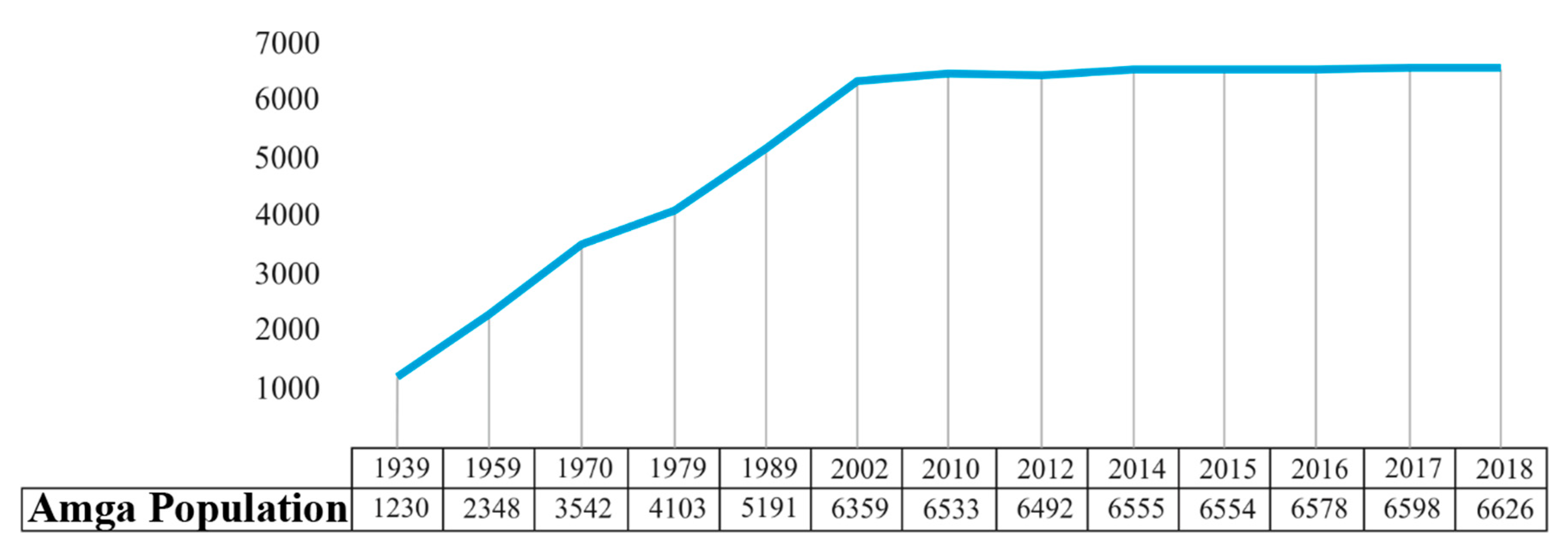
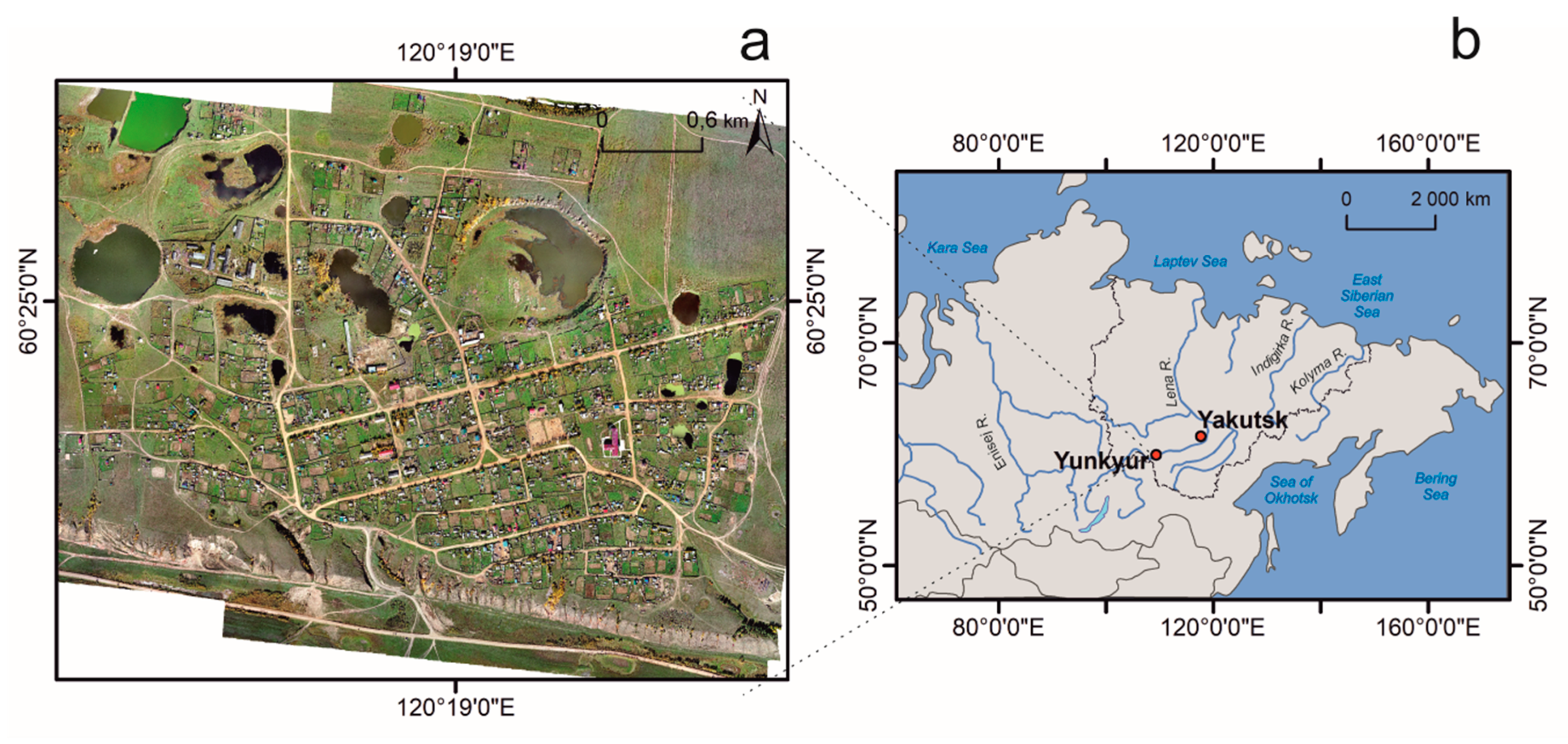
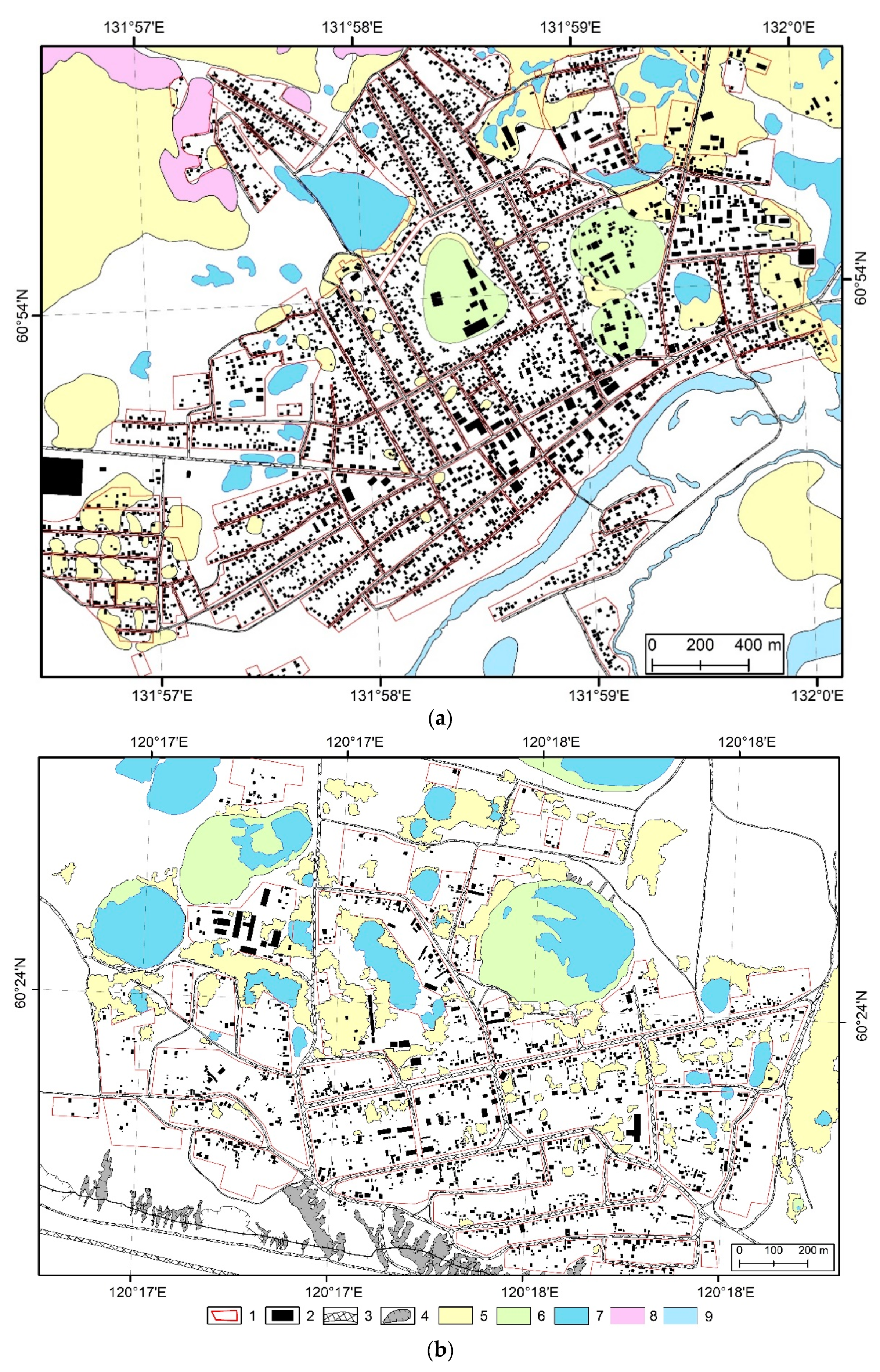
2.1.1. Amga Village
2.1.2. Yunkyur Village
2.2. Research Methods
3. Results and Discussions
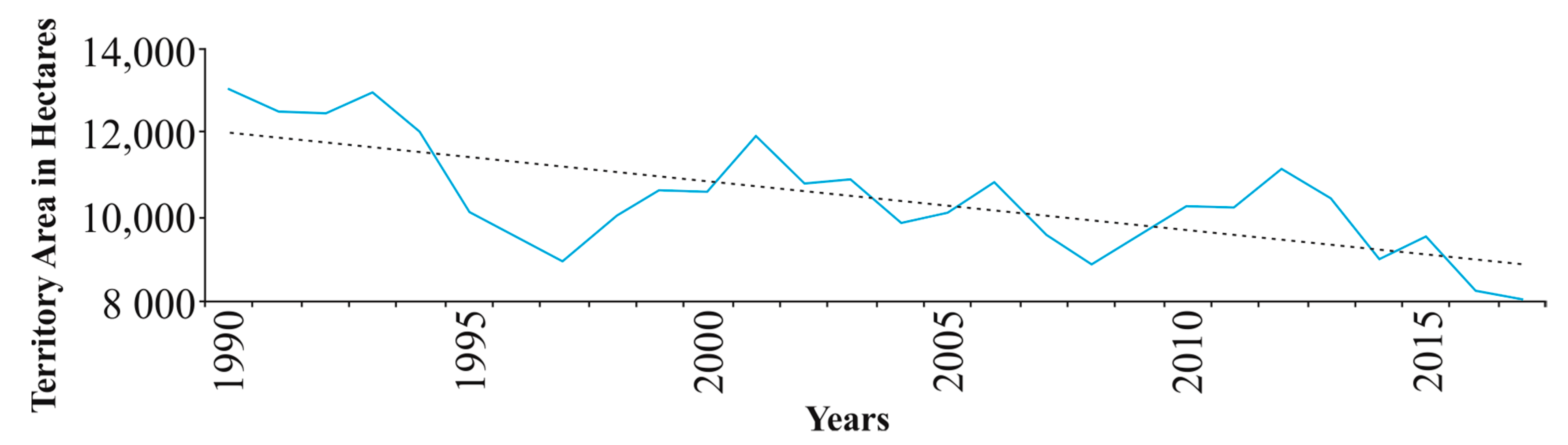
3.1. What Happens to the Permafrost in Amga and Yunkyur?
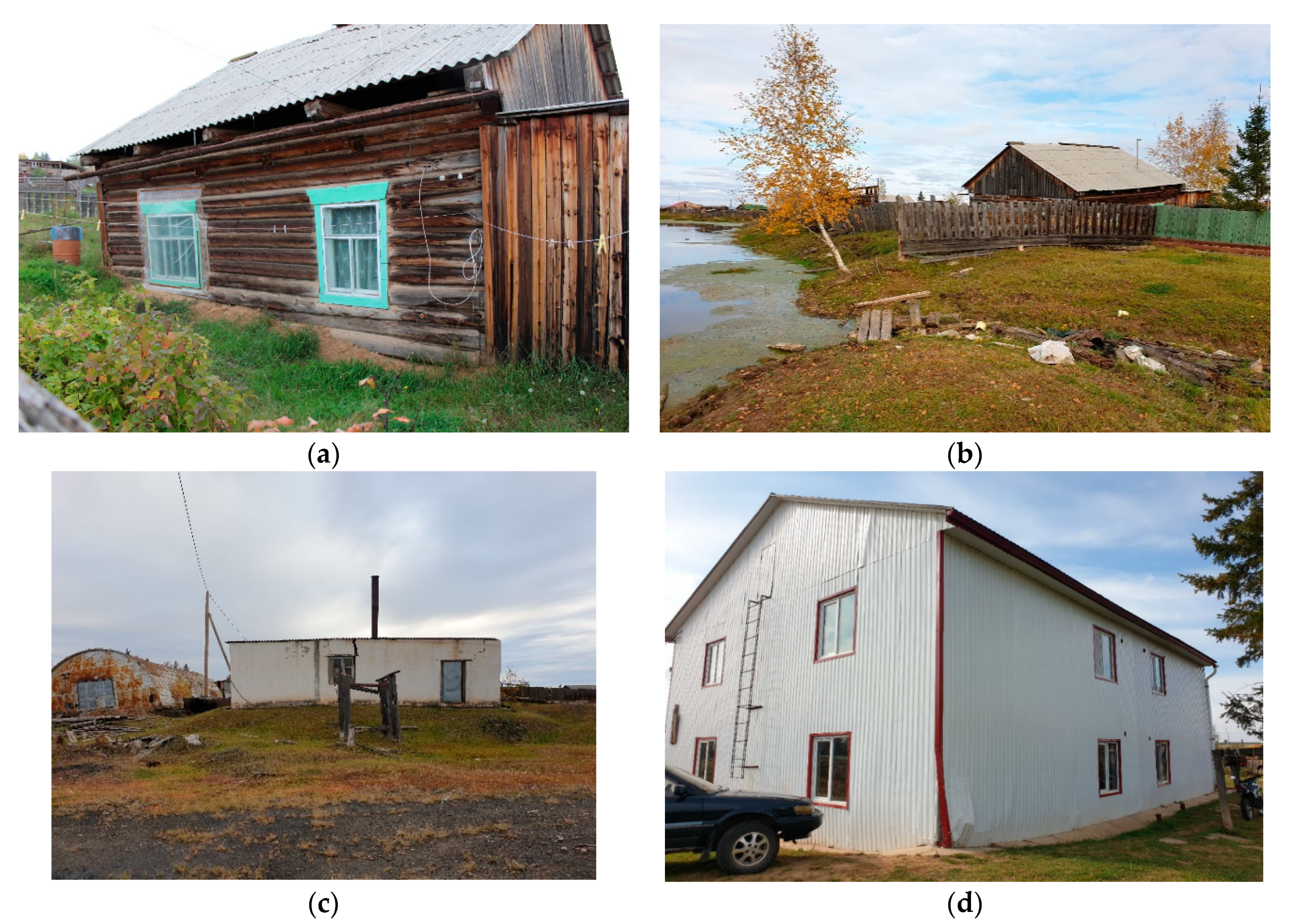
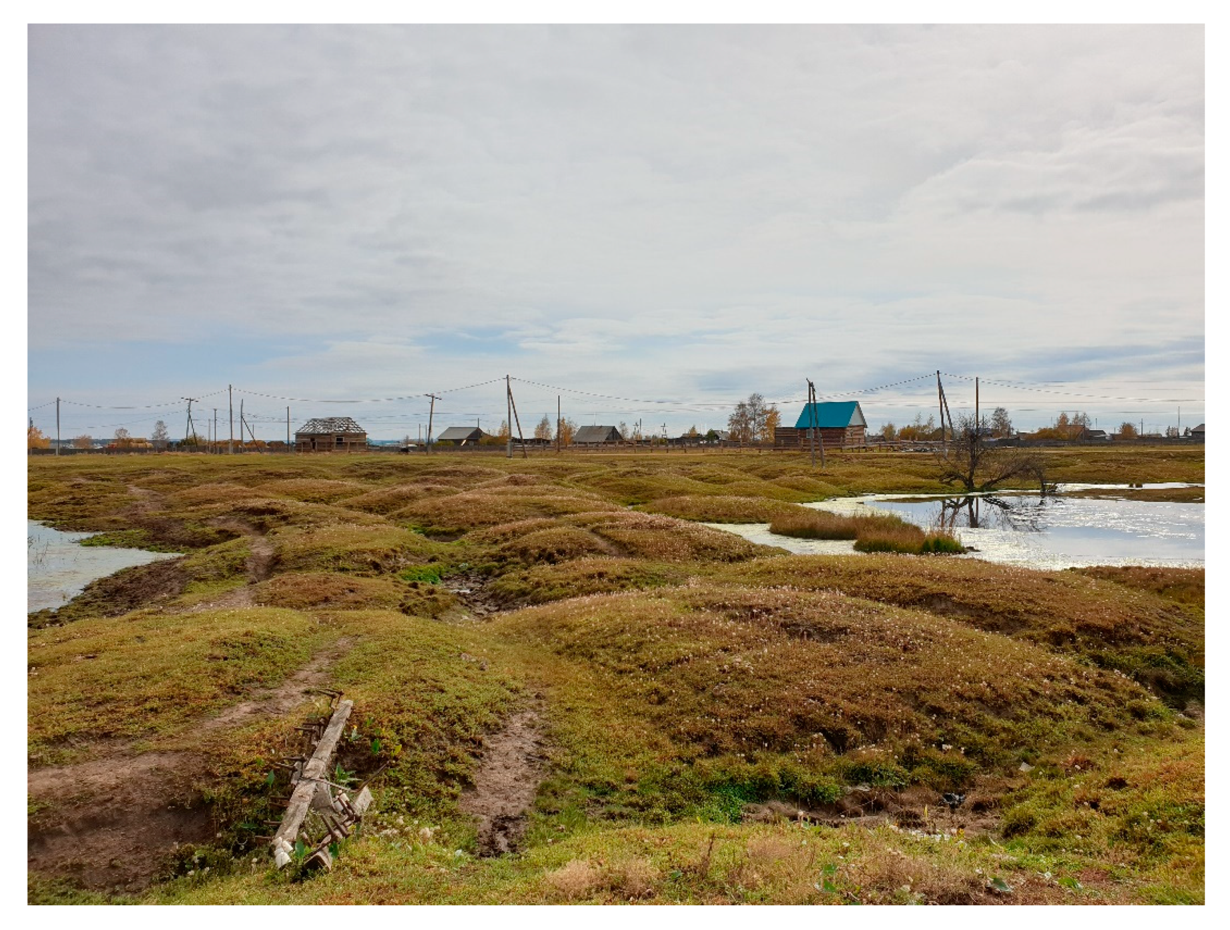
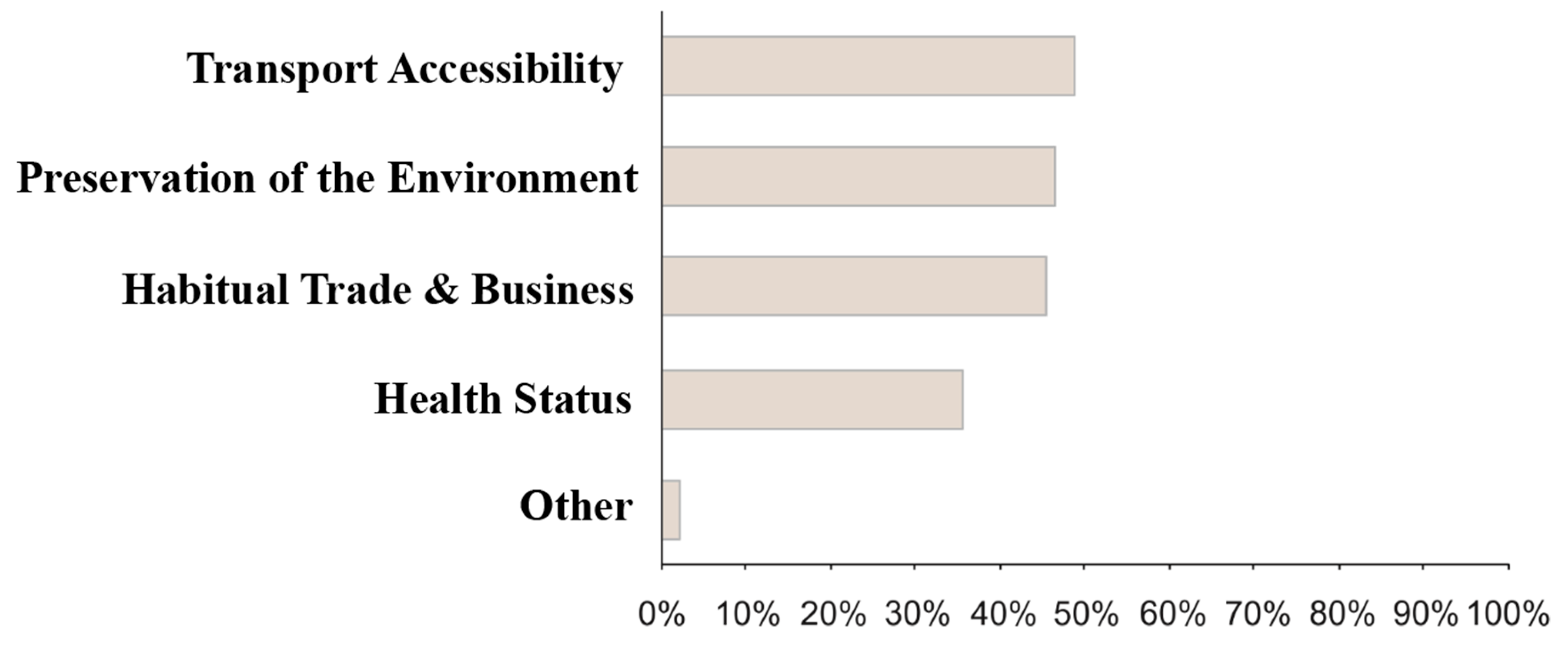
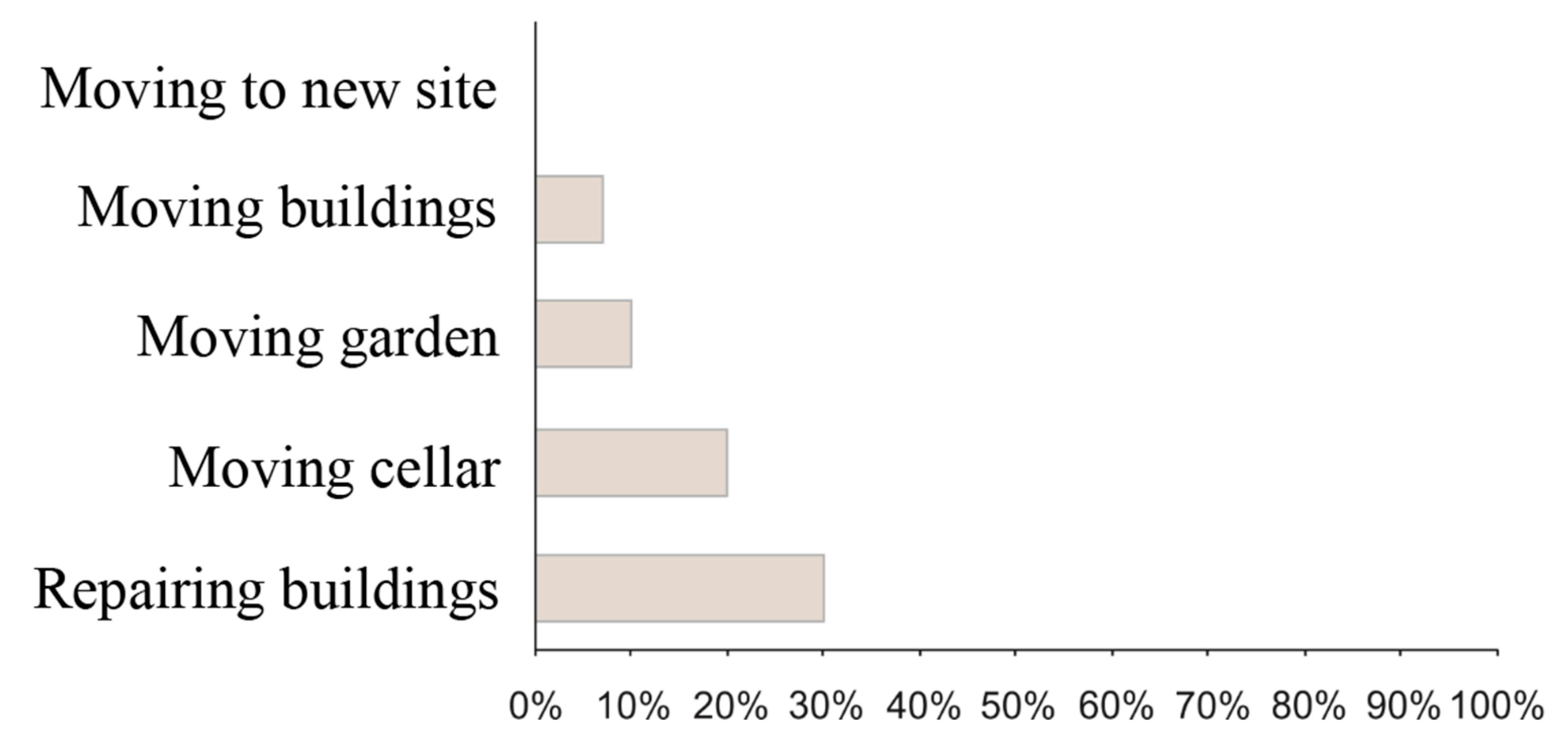
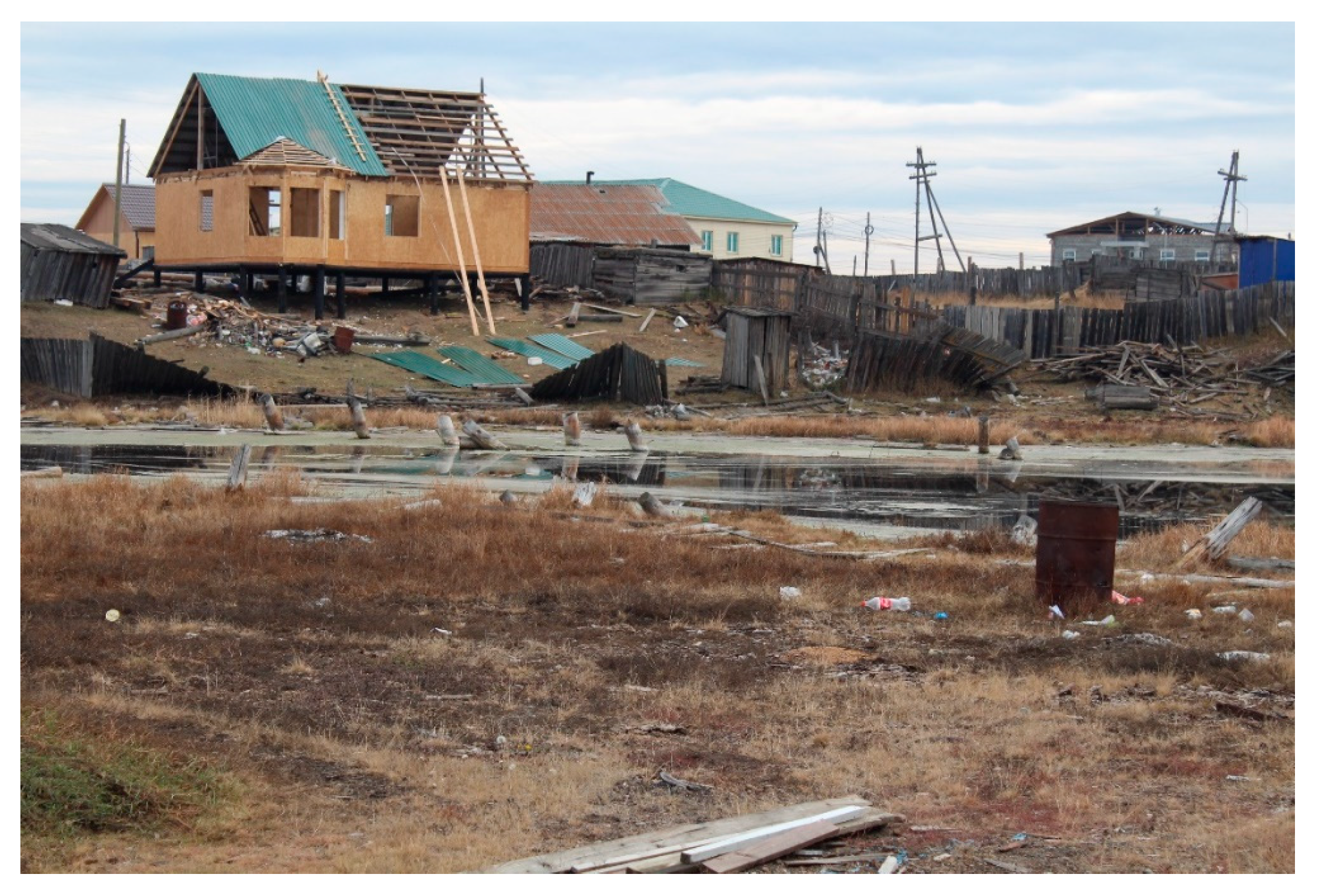
3.2. How Do These Processes Affect Local Residents?
4. Conclusions
Author Contributions
Funding
Data Availability Statement
Conflicts of Interest
References
- Konishchev, V.N. The reaction of permafrost to climate warming. Earth’s Cryosphere 2011, 15, 15–18. (In Russian) [Google Scholar]
- Fedorov, A.N.; Vasilyev, N.F.; Torgovkin, Y.I.; Shestakova, A.A.; Varlamov, S.P.; Zheleznyak, M.N.; Shepelev, V.V.; Konstantinov, P.Y.; Kalinicheva, S.S.; Basharin, N.I.; et al. Permafrost-landscape map of the Republic of Sakha (Yakutia) on a scale 1:1,500,000. Geosciences 2018, 8, 465. [Google Scholar] [CrossRef] [Green Version]
- Fedorov, A.N.; Gavriliev, P.P.; Konstantinov, P.Y.; Hiyama, T.; Iijima, Y.; Iwahana, G. Estimating the water balance of a thermokarst lake in the middle of the Lena River Basin, eastern Siberia. Ecohydrology 2014, 7, 188–196. [Google Scholar] [CrossRef]
- Saito, H.; Iijima, Y.; Basharin, N.I.; Fedorov, A.N.; Kunitsky, V.V. Thermokarst development detected from high-definition topographic data in Central Yakutia. Remote Sens. 2018, 10, 1579. [Google Scholar] [CrossRef] [Green Version]
- Kachurin, S.P. Thermokarst in the USSR; Publishing House of the USSR Academy of Sciences: Moscow, Russia, 1961. (In Russian) [Google Scholar]
- Fedorov, A.N.; Konstantinov, P.Y. Recent Changes in Ground Temperature and the Effect on Permafrost Landscapes in Central Yakutia. In Proceedings of the 9th International Conference on Permafrost, Fairbanks, AK, USA, 28 June–3 July 2008; pp. 433–438. [Google Scholar]
- Fedorov, A.N.; Iwahana, G.; Konstantinov, P.Y.; Machimura, T.; Argunov, R.N.; Efremov, P.V.; Lopez, L.M.C.; Takakai, F. Variability of permafrost and landscape conditions following clear cutting of larch forest in Central Yakutia. Permafr. Periglac. Process. 2017, 28, 331–338. [Google Scholar] [CrossRef]
- Fedorov, A.N.; Konstantinov, P.Y.; Vasilyev, N.F.; Shestakova, A.A. The Influence of boreal forest dynamics on the current state of permafrost in Central Yakutia. Polar Sci. 2019, 22, 100483. [Google Scholar] [CrossRef]
- Efimov, A.I.; Grave, N.A. Buried ice in the Abalakh Lake area. Soc. Stroit. 1940, 10–11, 67–78. (In Russian) [Google Scholar]
- Shur, Y.; Hinkel, K.M.; Nelson, F.E. The transient layer: Implications for geocryology and climate-change science. Permafr. Periglac. Process. 2005, 16, 5–17. [Google Scholar] [CrossRef]
- Grosse, G.; Romanovsky, V.; Jorgenson, T.; Anthony, K.W.; Brown, J.; Overduin, P.P. Vulnerability and feedbacks of permafrost to climate change. Eos Trans. Am. Geophys. Union 2011, 92, 73–74. [Google Scholar] [CrossRef]
- Streletskiy, D.A.; Suter, L.J.; Shiklomanov, N.I.; Porfiriev, B.N.; Eliseev, D.O. Assessment of climate change impacts on buildings, structures and infrastructure in the Russian regions on permafrost. Environ. Res. Lett. 2019, 14, 25003. [Google Scholar] [CrossRef]
- Takakura, H.; Iijima, Y.; Ignatieva, V.B.; Fedorov, A.; Manasori, G.; Toshikazu, T. Permafrost and Culture. Global Warming and the Republic of Sakha (Yakutia), Russian Federation; Center for Northeast Asian Studies, Tohoku University: Tohoku, Japan, 2019. [Google Scholar]
- Shiklomanov, N.I.; Streletskiy, D.A.; Grebenets, V.I.; Suter, L. Conquering the Permafrost: Urban Infrastructure development in Norilsk, Russia. Polar Geogr. 2017, 40, 273–290. [Google Scholar] [CrossRef]
- Shiklomanov, N.I.; Streletskiy, D.A.; Swales, T.B.; Kokorev, V.A. Climate Change and stability of urban infrastructure in Russian permafrost regions: Prognostic assessment based on GCM climate projections. Geogr. Rev. 2017, 107, 125–142. [Google Scholar] [CrossRef]
- Ulrich, M.; Habeck, J.O. The 1st IPA Action Group’ Permafrost and Culture’ (Field) Workshop. Frozen Ground: The News Bulletin of the International Permafrost Association. 2015, Volume 39, pp. 3–4. Available online: http://ipa.arcticportal.org/images/fg/FrozenGround_39.pdf (accessed on 2 July 2020).
- Crate, S.; Ulrich, M.; Habeck, J.; Desyatkin, A.; Desyatkin, R.; Fedorov, A.; Hiyama, T.; Iijima, Y.; Ksenofontov, S.; Mészáros, C.; et al. Permafrost livelihoods: A transdisciplinary review and analysis of thermokarst-based systems of indigenous land use. Anthropocene 2017, 18, 89–104. [Google Scholar] [CrossRef]
- Takakura, H. Arctic Pastoralist Sakha: Ethnography and Micro-Adaptation in Siberia; Trans Pacific Press: Melbourne, VI, Australia, 2015. [Google Scholar]
- Takakura, H. Limits of pastoral adaptation to permafrost regions caused by climate change among the Sakha people in the middle basin of Lena River. Polar Sci. 2016, 10, 395–403. [Google Scholar] [CrossRef]
- Crate, S. Climate change and ice dependent communities: Perspectives from Siberia and Labrador. Polar J. 2012, 2, 61–75. [Google Scholar] [CrossRef]
- Crate, S.A.; Fedorov, A.N. A methodological model for exchanging local and scientific climate change knowledge in northeastern Siberia. Arctic 2013, 66, 338–350. [Google Scholar] [CrossRef] [Green Version]
- Takakura, H.; Fujioka, Y.; Ignatyeva, V.; Tanaka, T.; Vinokurova, N.; Grigorev, S.; Boyakova, S. Differences in local perceptions about climate and environmental changes among residents in a small community in Eastern Siberia. Polar Sci. 2020, 100556. [Google Scholar] [CrossRef]
- Doloisio, N.; Vanderlinden, J.P. The perception of permafrost thaw in the Sakha Republic (Russia). Polar Sci. 2020, 26, 100589. [Google Scholar] [CrossRef]
- Svinoboev, A.N.; Neustroeva, A.B. Climate change and living conditions in the North in the perception of the indigenous population. Urban Stud. 2017, 4, 28–39. (In Russian) [Google Scholar] [CrossRef]
- Boyakova, S.I.; Vinokurova, L.I.; Ignatjeva, V.B.; Filippova, V.V. Social Consequences and adaptation of the population of the Sakha Republic (Yakutia) to the extreme situations of natural character (based on materials of sociological investigation in 2009–2010). N-E Humanit. Bull. 2011, 2, 37–41. (In Russian) [Google Scholar]
- Vinokurova, L.I.; Filippova, V.V.; Sannikova, Y.M. The rural cultural landscape in Yakutia: The experience an interdisciplinary field project. N-E Humanit. Bull. 2014, 2, 17–24. (In Russian) [Google Scholar]
- Chambers, R.; Conway, G. Sustainable Rural Livelihoods: Practical Concepts for the 21st Century; Institute of Development Studies: Falmer, UK, 1992. [Google Scholar]
- Smirnov, N.S. Scientific and Applied Reference Book on the Climate of the Ussr. Series 3. Long-Term Data. Parts 1–6. Issue 24. Book 1; Gidrometeoizdat: Leningrad, Russia, 1989; p. 607. (In Russian) [Google Scholar]
- Fedorov, A.N.; Botulu, T.A.; Vasiliev, I.S.; Varlamov, S.P.; Gribanova, S.P.; Dorofeev, I.V. Permafrost-Landscape Map of the Yakut ASSR, Scale 1:2,500,000, 2 Sheets; Melnikov, P.I., Ed.; Gosgeodezia: Moscow, Russia, 1991. (In Russian) [Google Scholar]
- Fedorov, A.N.; Botulu, T.A.; Varlamov, S.P.; Vasiliev, I.S.; Gribanova, S.P.; Dorofeev, I.V.; Klimovsky, I.V.; Samsonova, V.V.; Soloviev, P.A. Permafrost Landscapes in Yakutia. Explanation Note to the Permafrost-Landscape Map of the Yakut ASSR at a 1:2,500,000 Scale; GUGK: Novosibirsk, Russia, 1989. (In Russian) [Google Scholar]
- Safronov, F.G. Russians in Northeast Asia in the 17th–Mid-19th Centuries: Management, Service People, Peasants, Urban Population; Nauka Publishing House: Moscow, Russia, 1978. (In Russian) [Google Scholar]
- Fedorov, V.V. The History of the Amginsky Ulus in Dates; Poligrafist: Yakutsk, Russia, 1996. (In Russian) [Google Scholar]
- Makharov, E.M. Amginsky Ulus: History. Culture. Folklore; Bichik: Yakutsk, Russia, 2001. (In Russian) [Google Scholar]
- Statistical Yearbooks of the Republic of Sakha (Yakutia) 2000–2018. Available online: https://sakha.gks.ru (accessed on 26 August 2020).
- The Population of the USSR as of January 17, 1939. Statistical Book; Gosplanizdat: Moscow, Russia, 1941. (In Russian)
- All-Union Population Censuses. Available online: http://www.demoscope.ru (accessed on 2 September 2020).
- Soloviev, P.A. Permafrost of Northern Part of the Lena-Amga Interfluve; Publishing house of the USSR Academy of Sciences: Moscow, Russia, 1959. (In Russian) [Google Scholar]
- Redko, M.A.; Kulagin, Y.D.; Pavlyak, A.F.; Gorizontov, V.V.; Gorizontova, T.M.; Kuzmina, F.I.; Kostenko, S.A. Yunkyurskiy Nasleg; Central District Library: Olyokminsk, Russia, 2001. (In Russian) [Google Scholar]
- Municipal Archives of the Municipal District “Olyokminsky District” [Archival Document]. Fund 66. Case 1. Inventory 1. Sheets 1–2. (In Russia)
- Municipal Archives of the Municipal District “Olyokminsky District”. [Archival Document]. Fund 36. Case 1. Inventory 87. Sheet 1. (In Russia)
- Current archive of the administration of the municipal district “Malzhagarsky nasleg” of the Olyokminsky district of the Republic of Sakha (Yakutia). [Archival document]. Passport of the Socio-Economic Development of the Malzhagarsky Nasleg of the Olyokminsky District of the Republic of Sakha (Yakutia) for 2019. (In Russia)
- Municipal Archives of the Municipal District “Olyokminsky District”. [Archival Document]. Fund 3. Case 1. Inventory 12. Sheets 4–5. (In Russia)
- Municipal Archives of the Municipal District “Olyokminsky District”. [Archival Document]. Fund 3. Case 2. Inventory 378. Sheet 2. (In Russia)
- Current archive of the administration of the municipal district “Malzhagarsky Nasleg” of the Olyokminsky district of the Republic of Sakha (Yakutia). [Archival document]Passport of the Socio-Economic Development of the Malzhagarsky Nasleg of the Olyokminsky District of the Republic of Sakha (Yakutia) for 2012. (In Russia)
- ESRI ArcGIS. Available online: https://www.arcgis.com/home/item.html?id=10df2279f9684e4a9f6a7f08febac2a9 (accessed on 2 March 2020).
- Skachkov, Y.B. Mean annual air temperature variation in the Republic of Sakha (Yakutia) during the last 50 years. In Proceedings of the IX International Symposium Balance of Carbon, Water and Energy and the Climate of the Boreal and Arctic Regions with a Special Focus on Eastern Eurasia, Yakutsk, Russia, 1–4 November 2016; Nagoya University Press: Nagoya, Japan; Yakutsk, Russia, 2016; pp. 208–211. (In Russian). [Google Scholar]
- Streletskiy, D.A.; Sherstiukov, A.B.; Frauenfeld, O.W.; Nelson, F.E. Changes in the 1963–2013 shallow ground thermal regime in Russian permafrost regions. Environ. Res. Lett. 2015, 10, 125005. [Google Scholar] [CrossRef]
- Grosse, G.; Schirrmeister, L.; Siegert, C.; Kunitsky, V.V.; Slagoda, E.A.; Andreev, A.A.; Dereviagyn, A.Y. Geological and Geomorphological evolution of a sedimentary periglacial landscape in northeast Siberia during the late Quaternary. Geomorphology 2007, 86, 5–51. [Google Scholar] [CrossRef] [Green Version]
- Katamura, F.; Fukuda, M.; Bosikov, N.P.; Desyatkin, R.V. Charcoal records from thermokarst deposits in Central Yakutia, eastern Siberia: Implications for forest fire history and thermokarst development. Quat. Res. 2009, 71, 36–40. [Google Scholar] [CrossRef]
- Ulrich, M.; Wetterich, S.; Rudaya, N.; Frolova, L.; Schmidt, J.; Siegert, C.; Fedorov, A.N.; Zielhofer, C. Rapid thermokarst evolution during the Mid-Holocene in Central Yakutia, Russia. Holocene 2017, 27, 1899–1913. [Google Scholar] [CrossRef]
- Gotovtsev, S.P. Permafrost degradation is a serious danger. Sci. Technol. Yakutia 2016, 1, 45–49. (In Russian) [Google Scholar]
- Nikolaev, S.I. Sakha People; Yakutian Region: Yakutsk, Russia, 2009. (In Russian) [Google Scholar]


| Locality | Bylar Area, km2 | Alas Area, km2 | Number of Buildings and Structures within the Distribution of Modern Thermokarst Processes, Unit | Number of Courtyards Affected by Modern Thermokarst Processes, % |
|---|---|---|---|---|
| Amga | 6.5 | 0.3 | 540 | 18 |
| Yunkyur | 0.66 | 0.26 | 11 | 8 |
Publisher’s Note: MDPI stays neutral with regard to jurisdictional claims in published maps and institutional affiliations. |
© 2021 by the authors. Licensee MDPI, Basel, Switzerland. This article is an open access article distributed under the terms and conditions of the Creative Commons Attribution (CC BY) license (http://creativecommons.org/licenses/by/4.0/).
Share and Cite
Lytkin, V.; Suleymanov, A.; Vinokurova, L.; Grigorev, S.; Golomareva, V.; Fedorov, S.; Kuzmina, A.; Syromyatnikov, I. Influence of Permafrost Landscapes Degradation on Livelihoods of Sakha Republic (Yakutia) Rural Communities. Land 2021, 10, 101. https://doi.org/10.3390/land10020101
Lytkin V, Suleymanov A, Vinokurova L, Grigorev S, Golomareva V, Fedorov S, Kuzmina A, Syromyatnikov I. Influence of Permafrost Landscapes Degradation on Livelihoods of Sakha Republic (Yakutia) Rural Communities. Land. 2021; 10(2):101. https://doi.org/10.3390/land10020101
Chicago/Turabian StyleLytkin, Vasylii, Alexander Suleymanov, Lilia Vinokurova, Stepan Grigorev, Victoriya Golomareva, Svyatoslav Fedorov, Aitalina Kuzmina, and Igor Syromyatnikov. 2021. "Influence of Permafrost Landscapes Degradation on Livelihoods of Sakha Republic (Yakutia) Rural Communities" Land 10, no. 2: 101. https://doi.org/10.3390/land10020101