1. Introduction
According to the World Population Change Report published by the World Bank, the global population has increased by approximately 1 billion every 12 years since 1975. At the same time, the world has experienced rapid urbanization and a large influx of people into cities, with more than half of the population now living in urban areas, and this proportion is predicted to rise to two-thirds by 2050 [
1]. Transformation of the social economy increases the pressure on land use, and various types and forms of land use conflicts are widespread across the world [
2,
3,
4,
5,
6]. As the most populous country in the world, China has experienced unprecedented rapid urbanization and industrialization, with the urbanization level rising from 17.9% before the reform and opening-up to 63.89% in 2020. This extensive development model has made China face increasingly severe land use conflicts, which are mainly manifested in the disorderly expansion of urban and rural settlements occupying high-quality farmland and ecological spaces, leading to the fragmentation of cultivated land and a decline in the quality of the ecological environment, further threatening food security, ecological security and the sustainable development of urban and rural areas [
7,
8,
9,
10].
Land use conflict identification is the premise of land use conflict prevention, mediation and settlement and is the core focus of land-use conflict research. Land use conflict identification methods mainly includes participatory assessment [
11,
12], game theory [
13], landscape ecological risk assessment [
14,
15] and multi-objective comprehensive assessment [
8,
16,
17]. Participatory evaluation has strong subjectivity and is suitable for small-scale research. Game theory focuses on strategic analysis, which is difficult to achieve quantitative evaluation of land use conflicts [
16]. The landscape ecological risk assessment method only uses land use data and pays attention to landscape pattern characteristics of land use, but does not take social and economic factors into account [
15,
16]. The multi-objective comprehensive evaluation method has obvious advantages compared with other methods [
16,
18]. It can quantitatively evaluate land use conflicts at multiple scales, such as administrative divisions and grids, and can take socioeconomic and natural attributes into account.
Iojă, Niţă, Vânău, Onose and Gavrilidis [
19] selected 10 indicators from two variables: space and urban development, to evaluate the spatial distribution of land use conflicts at administrative units in Bucharest Metropolitan Area. Jiang, Meng and Zhu [
16] applied the multi-objective evaluation method and constructed a competitive evaluation index system for cultivated, construction and ecological land using two dimensions: land suitability and driving force of land use conversion and analyzed the temporal and spatial characteristics of land use conflicts in the middle reaches of the Heihe River. Zou, Liu, Wang, Yang and Wang [
8] evaluated the suitability of construction, agricultural and ecological land by selecting evaluation indices from four factors: nature, location, society and policy and further identified the types and intensities of land use conflicts. Jing et al. [
20] constructed a suitability evaluation index system for production, living and ecological land and identified potential land use conflicts. Kim and Arnhold [
21] measured land use conflicts in agricultural basins using two dimensions: land use preference and location importance.
These studies have provided many reference methods and a large number of important conclusions for the identification of land use conflicts and form an important starting point for this study. Although there is still a lack of unified standards and rules for the construction of the evaluation index system of land use conflicts, consensus has been reached on the causes of land use conflicts, and it is believed that land use multi-suitability, land resource scarcity and diversity of human needs are the fundamental causes of land use conflicts [
16,
22,
23,
24,
25]. They are also a necessary condition for land use conflicts. All three are indispensable. Unfortunately, there are a few quantitative assessments of land resource scarcity and diversity of human needs, although some socio-economic and policy indicators, such as population density [
16,
20], impact of central cities [
20,
23] and land use planning [
8,
16,
23], have been introduced. This will reduce the accuracy of land use conflict identification and the feasibility of land use conflict mediation.
In view of this, this study attempts to build a new framework for land use conflict identification based on land use multi-suitability, land resource scarcity and diversity of human needs and uses Jinan city as an example to conduct empirical research. This study expands the identification method of land use conflict, which is helpful to land use conflict mediation, promote rational use of land resources and optimize land spatial pattern.
2. Conceptual Framework
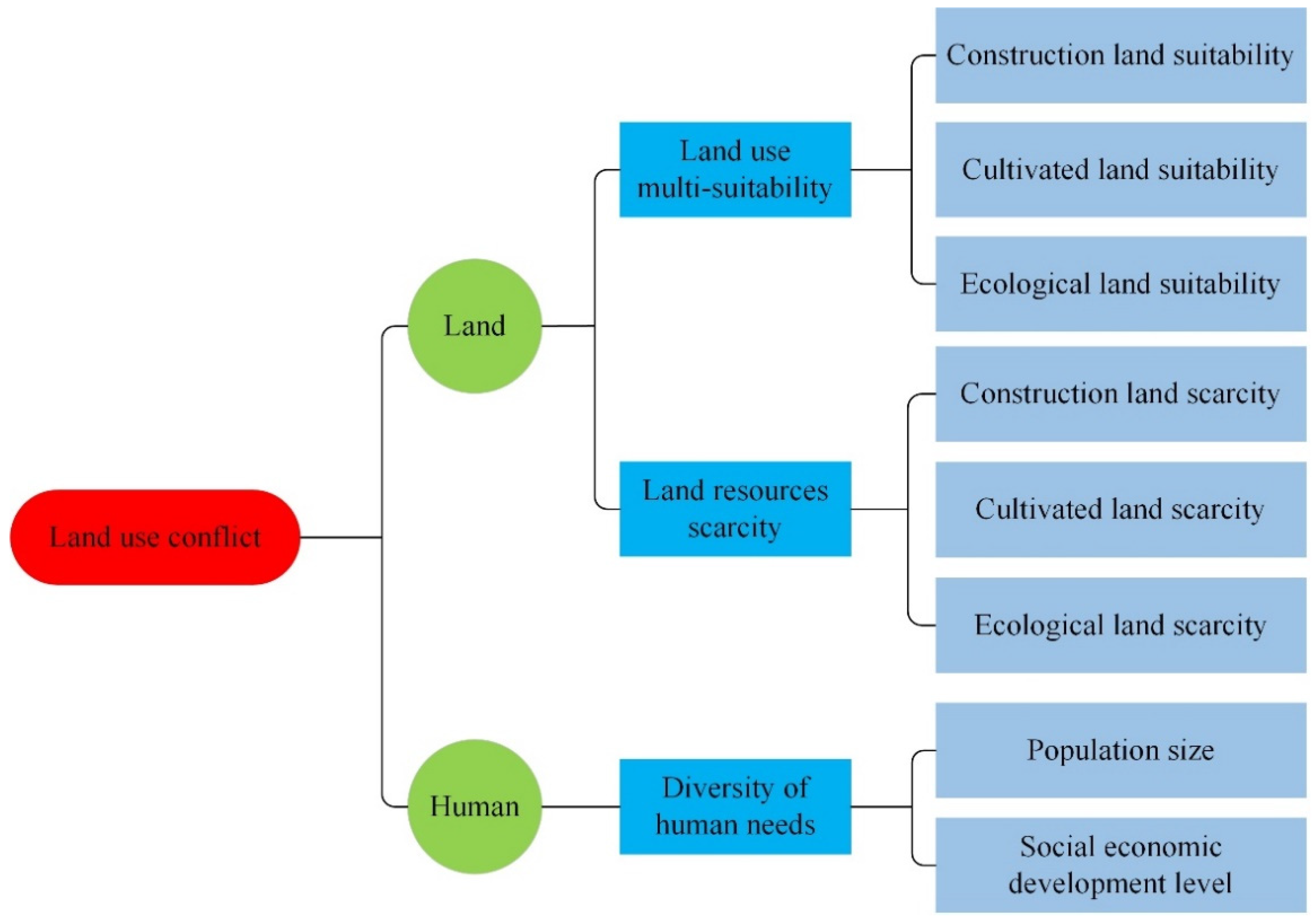
The essence of land use conflict is the contradiction between humans and land. Specifically, land use conflict is the result of the comprehensive effects of land use multi-suitability [
8,
17], land resource scarcity [
22,
24] and diversity of human needs [
24,
26] (
Figure 1).
Land use multi-suitability is an inherent attribute of land resources. The better the natural endowment and location conditions, the higher the land use multi-suitability. Land use suitability is divided into construction, cultivated and ecological land suitability. Land use multi-suitability can be determined by overlaying the evaluation results of construction, cultivation and ecological land suitability. Land accounts for only 29.2% of the Earth’s surface area, and the total amount of land resources is limited and scarce. However, scarcity is a relative concept, and the scarcity of land resources is relative to human needs. Therefore, land resource scarcity should be measured by the index of per capita land use, such as per capita construction land area, per capita cultivated land area and per capita ecological land area. In addition, it is worth noting that even if land resources are suitable for multiple uses, there will be no land use conflict if there is no human demand for them. Therefore, the diversity of human needs is also a key factor in land use conflicts [
8,
26]. The diversity of human needs is affected by the size of the population and the level of social and economic development. The larger the population and the higher the level of social and economic development, the greater the diversity of human needs.
3. Materials and Methods
3.1. Study Area
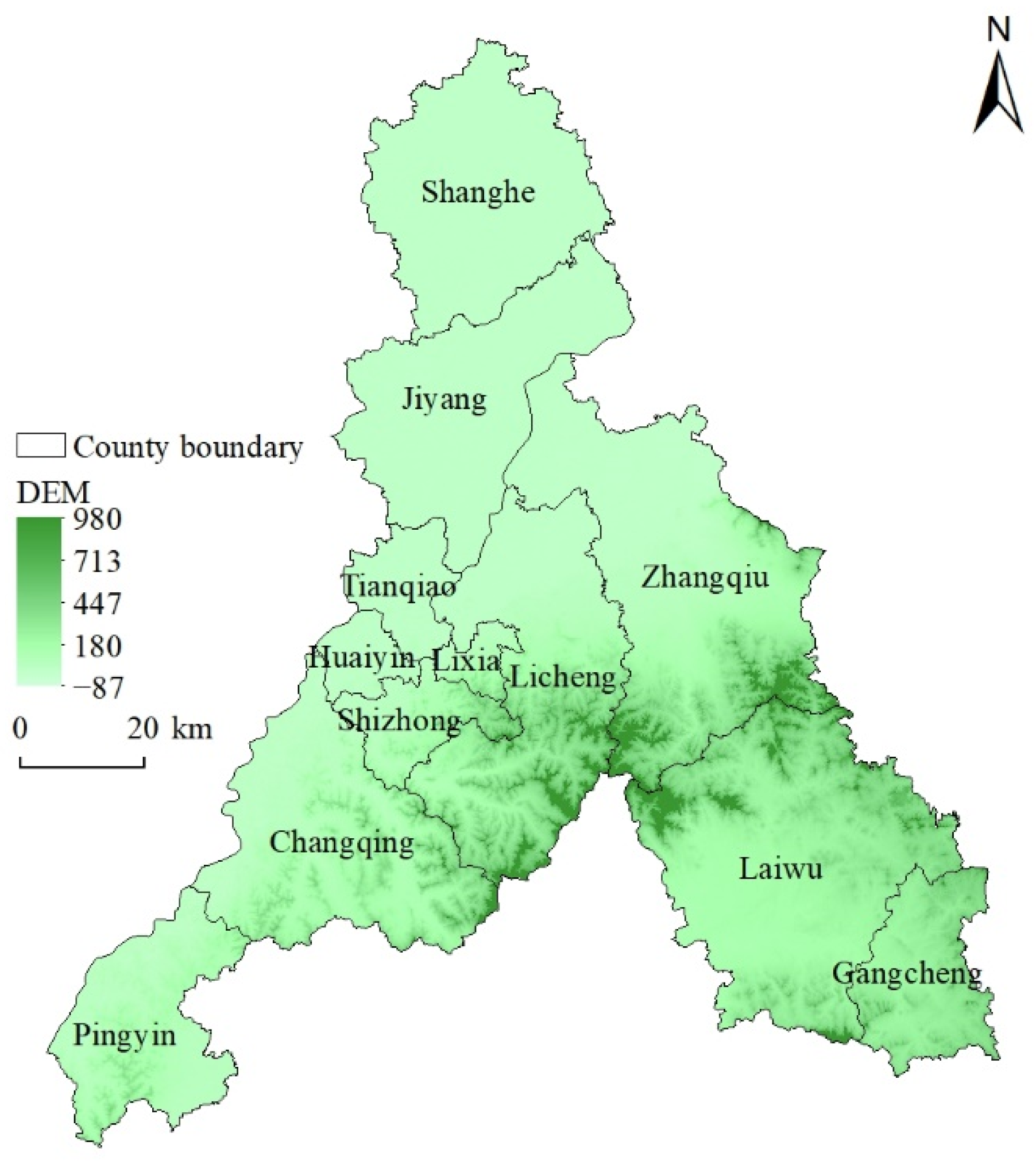
Jinan is located at the central and western parts of Shandong province, the southeastern edge of the North China Plain, the intersection of the low mountains and hills in the south of Shandong province and the alluvial plain in the northwest of Shandong province (
Figure 2). It is close to Mount Tai in the south and straddles the Yellow River to the north. The terrain is high in the south and low in the north. The city has jurisdiction over 12 county-level administrative regions, including 10 municipal districts and 2 counties, with a total area of 10,244.45 km
2. In 2020, the permanent resident population in Jinan was 9,202,432, the urbanization rate was 73.46%, and the GDP was 944.337 billion yuan. Due to the rapid advancement of urbanization and industrialization, as well as the accelerated transformation and development of the social economy, the disparity between population size and land use in Jinan has increased, causing a series of problems including urban sprawl, declining quality of the ecological environment and air pollution. In April 2021, the State Council agreed in principle to the Implementation Plan for the Construction of the Starting Area for the Conversion of Old and New Growth Drivers in Jinan, which provided new development opportunities for Jinan and put forward higher requirements for rational land use and the optimization of territorial spatial patterns.
3.2. Data Sources
The data required for land use conflict evaluation include a digital elevation model (DEM), geological hazard susceptibility rate, land use status map, grade of cultivated land use, normalized difference vegetation index (NDVI) and total population and gross domestic product (GDP) at county level. DEM (30 m spatial resolution) and NDVI (1 km spatial resolution) data were obtained from the Data Center of Resources and Environmental Science, Institute of Geographic Resources and Resources (
https://www.resdc.cn, accessed on 22 August 2021). The geological hazard distribution map in JPG format was collected by our research group from geological disaster department of Shandong Province in the process of project research and was registered and vectorized. The 2018 land use status map was provided by Shandong Land Survey and Planning Institute, and the cultivated land use grade data were extracted from the agricultural land grading database. The total population and GDP data at county level were from Jinan Statistical Yearbook in 2019.
3.3. Construction of Land Use Conflict Evaluation Index System
3.3.1. Construction of Land Use Multi-Suitability Evaluation Index System
Land use multi-suitability refers to the suitability of using land resources for different functions; for example, fertile and flat land can be used as agricultural, construction or ecological land. However, different uses require different conditions [
27]. Therefore, a land suitability evaluation index system should be constructed depending on the use. Based on relevant studies [
16,
17,
23,
27], according to the principles of (1) reflecting the connotation of suitability, (2) high frequency of use and (3) strong representativeness and combined with the accessibility of data [
28], evaluation indexes were selected to construct the evaluation index system of construction land, cultivated land and ecological land suitability.
(1) Evaluation index system for suitability of construction land.
The suitability of construction land is mainly affected by the natural and location conditions (
Table 1). The natural conditions include elevation, slope and geological hazard susceptibility. The higher the elevation and the steeper the slope, the more difficult the construction, the higher the cost and the lower the suitability of the land for construction. Geological disasters can damage buildings and even endanger residents’ lives and property. The higher the rate of occurrence of geological disasters, the lower the suitability of the land for construction. The location condition is characterized by the distance from the city and the distance from the road. The city is the center of social and economic activities, and the road is the reflection of the degree of transportation convenience. The closer the distance to the city and the road, the higher the suitability of the land for construction.
(2) Evaluation index system for cultivated land suitability.
Cultivated land suitability was evaluated using two variables: natural endowment and farming convenience (
Table 2). Low elevation, flat terrain and fertile soil are ideal for arable land, where soil organic matter content, available soil thickness, soil texture, soil pH, irrigation conditions and other factors can affect soil fertility. Based on the above indicators, China’s agricultural authorities have implemented a classification and grading system for agricultural land; therefore, the grade was selected to represent the fertility of cultivated land. Farming convenience is also an important aspect of the suitability of cultivated land. Remote and inconveniently located land often has poor natural endowment and is more likely to be abandoned; thus, its cultivated land suitability is low.
(3) Evaluation index system for ecological land suitability.
There are relatively few limiting factors for ecological land suitability. The suitability of ecological land was evaluated using two variables: natural endowment and human disturbance (
Table 3). The better the natural endowment, the less human disturbance and the more suitable the land is for ecological activity. NDVI and land use type are used to represent natural endowment and human disturbance, respectively. The higher the vegetation index, the better the natural endowment and the higher the ecological suitability grade. According to the intensity of human activities on different land use types, land use types are graded and assigned. The higher the intensity of human activities, the lower the ecological suitability. For example, the construction land has the highest intensity of human activities and lowest ecological suitability, and the value is 20. The intensity of human activities in forestland is weak and the ecological suitability is high, and the value is 100.
3.3.2. Construction of Land Resource Scarcity Evaluation Index System
The per capita construction land area, per capita cultivated land area and per capita ecological land area were selected to represent the scarcity of construction land, cultivated land and ecological land (
Table 4). The larger the per capita land area, the lower the scarcity.
3.3.3. Constructing of Human Needs Diversity Evaluation Index System
Population size and the level of economic development are two key factors that affect the diversity of human needs (
Table 5). The larger the population and the higher the level of economic development, the richer the diversity of human needs; therefore, total population and GDP were selected to represent the population and the economic development level, respectively, to evaluate the diversity of human needs.
3.4. Index Quantification, Grading Assignment and Weight Determination
According to the characteristics of the data, we adopt a variety of methods to quantify, grade and assign the evaluation index, including the classification assignment method and natural breakpoint method. For classified data, such as geological disaster-prone areas and land use types, the corresponding relationship between types and grades is established by using a classification assignment method based on relevant studies, and corresponding scores are assigned. Specifically, geological hazard susceptibility was divided into four grades—none, low, medium and high—and assigned scores of 100, 60, 40, and 20, respectively. The grade of the cultivated land in Jinan city is 6–11, and 6 and 7 are assigned to 100, 8 and 9 to 80, 10 to 60, 11 to 40 and non-cultivated land to 20. Land use types were divided into five grades based on the intensity of human activities in each land use type and assigned values. For numerical data, such as DEM and distance index, the natural breakpoint method is used to divide them into 5 grades with the help of ArcGIS software, and the corresponding scores were assigned. Besides, based on the grading standards of the slope in the grading regulations of agricultural land, slopes were divided into five grades: <2°, 2°–6°, 6°–15°, 15°–25° and >25°.
Common methods for determining the weights include expert scoring, the analytic hierarchy process, the entropy value method and principal component analysis. Of these, the combination of expert scoring and analytic hierarchy process has the advantages of making full use of expert experience and being simple and easy to operate. Therefore, this study adopted the expert scoring method and the analytic hierarchy process to comprehensively determine the weight of evaluation indicators.
3.5. Land Use Conflict Index Calculation
According to the conceptual framework of land use conflict identification, the following linear weighted sum model was used to calculate the land use conflict index:
Where LUC represents the land use conflict index, MS represents land use multi-suitability index, Sca represents land resource scarcity index, and represents diversity of human needs. , and are the weights of MS, , and , respectively. ConLSu, CulLSu and EcoLSu represent the suitability of construction land, cultivated land and ecological land, respectively. ConLSca, CulLSca and represent the scarcity of construction land, cultivated land and ecological land, respectively. Pop stands for the total population.
The natural breakpoint method was used in ArcGIS to divide the results of the evaluation of construction land suitability, cultivated land suitability, ecological land suitability, land use multi-suitability, land resource scarcity, human needs diversity and land use conflict into three levels: high, medium and low.
4. Results
4.1. Land Use Suitability
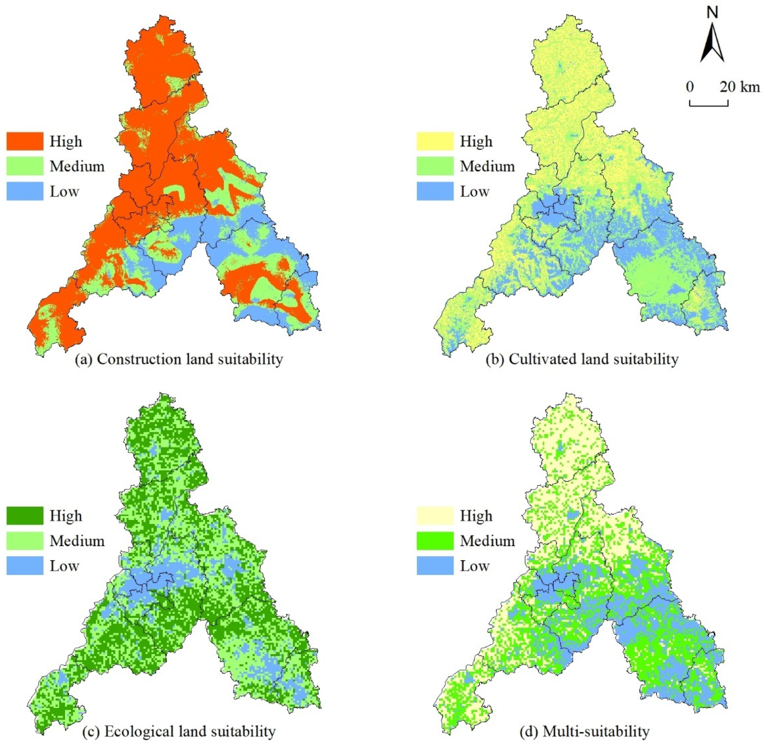
4.1.1. Construction Land Suitability
Areas with high suitability for construction accounted for the highest proportion (58.39%) and were concentrated in Shanghe county and Jiyang, Tianqiao, Huaiyin, Shizhong and Lixia districts, as well as the northern Licheng district, northern Zhangqiu city, western Changqing district and Pingyin county (
Figure 3). Of these, Tianqiao, Huaiyin, Shizhong and Lixia districts are the central districts of Jinan with developed transportation and obvious regional advantages. Shanghe county and Jiyang district are in the North China Plain where the terrain is flat and geological disasters do not occur easily. Areas with low construction land suitability accounted for the smallest proportion (17.23%) and were mainly distributed in the east of Changqing district, the south of Licheng district, the south of Zhangqiu city and the north of Laiwu district. These areas are in the southern mountainous region and have high terrain and steep slopes, are prone to geological disasters, are far away from towns, have inconvenient transportation and have low suitability for use as construction land. The proportion of areas with medium suitability for construction was 24.38% and were relatively spatially scattered.
4.1.2. Cultivated Land Suitability
The suitability of land for cultivation was mainly medium, accounting for 39.28% of the area studied. The proportion of areas with high suitability for cultivation was 34.00%. The area with low cultivated land suitability accounted for the lowest proportion (26.72%). Areas with high suitability for cultivation are mainly distributed in the north of Jinan city, particularly in Shanghe county and Jiyang district. They are rich in cultivated land resources, have flat terrain, fertile soil, abundant water resources and good irrigation and drainage conditions. They are important agricultural production areas and grain production bases. The suitability of land for cultivation in the southern mountainous area is low due to the influence of topography and farming convenience. The areas with medium suitability for cultivation were relatively scattered, but concentrated in the middle of Laiwu district.
4.1.3. Ecological Land Suitability
The proportions of areas with high and medium ecological land suitability were similar (42.24% and 42.05%), while the proportion of areas with low ecological land suitability was small (15.71%). The areas with low ecological land suitability are mainly urban land and rural residential land, which have low vegetation coverage and high intensity of human activities and are not suitable for use for ecological activities. The areas with high and middle ecological land suitability are adjacent and have a wide distribution range. Of these, the southern mountainous area has higher forest coverage and less human disturbance. Therefore, land with high ecological suitability is widely distributed here.
4.1.4. Land Use Multi-Suitability
Land use multi-suitability of in Jinan is relatively high and is dominated by medium to high suitability, accounting for 74.23% of the total land area, while the proportion of low multi-suitability is relatively small (25.77%). The spatial distribution of land use multi-suitability is affected by topography and is higher in the north and lower in the south (
Figure 3). The areas with high land use multi-suitability mainly distributed in Shanghe county, Jiyang district, northern Tianqiao district, northern Licheng district, northern Zhangqiu district, western Changqing district and some parts of Pingyin county. In these regions, the terrain is flat, the incidence of geological disasters is low, urban and rural settlements are densely distributed, transportation is convenient, and idle land use is relatively low; thus, land use multi-suitability is high. Medium land use multi-suitability is concentrated in the southern parts of Licheng and Zhangqiu districts, the western part of Changqing district, Pingyin county, the central part of Laiwu district and some parts of Gangcheng district. The multi-suitability of land in urban built-up areas and southern mountainous areas is low.
4.2. Scarcity of Land Resources
The evaluation indicators of land resource scarcity and human needs diversity include socioeconomic data such as population size and GDP. In China, the smallest statistical unit of the above socioeconomic data is the county-level administrative division. Therefore, the county-level administrative division was taken as the scale for the analysis of land resource scarcity and human needs diversity.
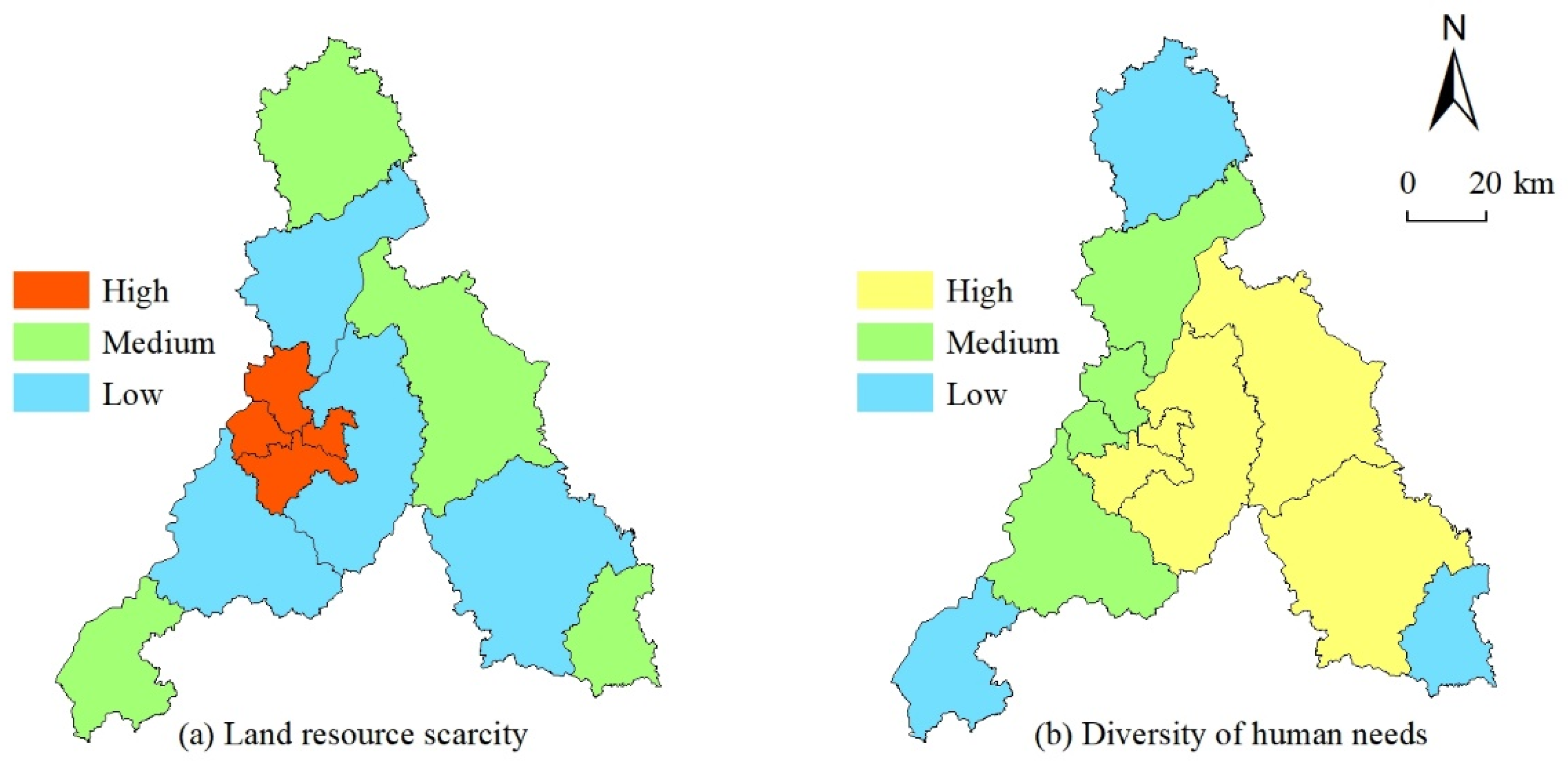
The spatial distribution of land resource scarcity is obviously different (
Figure 4). Tianqiao, Huaiyin, Lixia and Shizhong districts in the central part of Jinan have the highest land resource scarcity. These areas are located in the center of Jinan, with high urbanization levels, large populations, limited arable and ecological land and small per capita construction land scales. Land resource scarcity in Jiyang, Licheng, Changqing and Laiwu is low. Among them, Jiyang is located at the edge of north China Plain, rich in cultivated land resources; Changqing and Laiwu belong to mountainous areas and are rich in ecological resources. In addition, these areas are still in the stage of rapid urbanization, with extensive land use and a large per capita construction land scale. Shanghe, Zhangqiu, Pingyin and Gangcheng have medium land resource scarcity.
4.3. Diversity of Human Needs
The diversity of human needs in Jinan is greatly affected by the level of social and economic development, resulting in high diversity in the middle and low diversity in the north and south (
Figure 4). Lixia, Shizhong, Licheng, Zhangqiu and Laiwu districts have the highest diversities of human needs. These areas have a high level of social and economic development, with a total population of 6484–10518 million and GDP of 593.51–149.48 billion yuan. The diversity of human needs in Jiyang, Tianqiao, Huaiyin and Changqing districts are medium. The population size and GDP are lowest in Shanghe and Pingyin counties and Gangcheng district, resulting in the lowest diversity of human needs.
4.4. Land Use Conflict
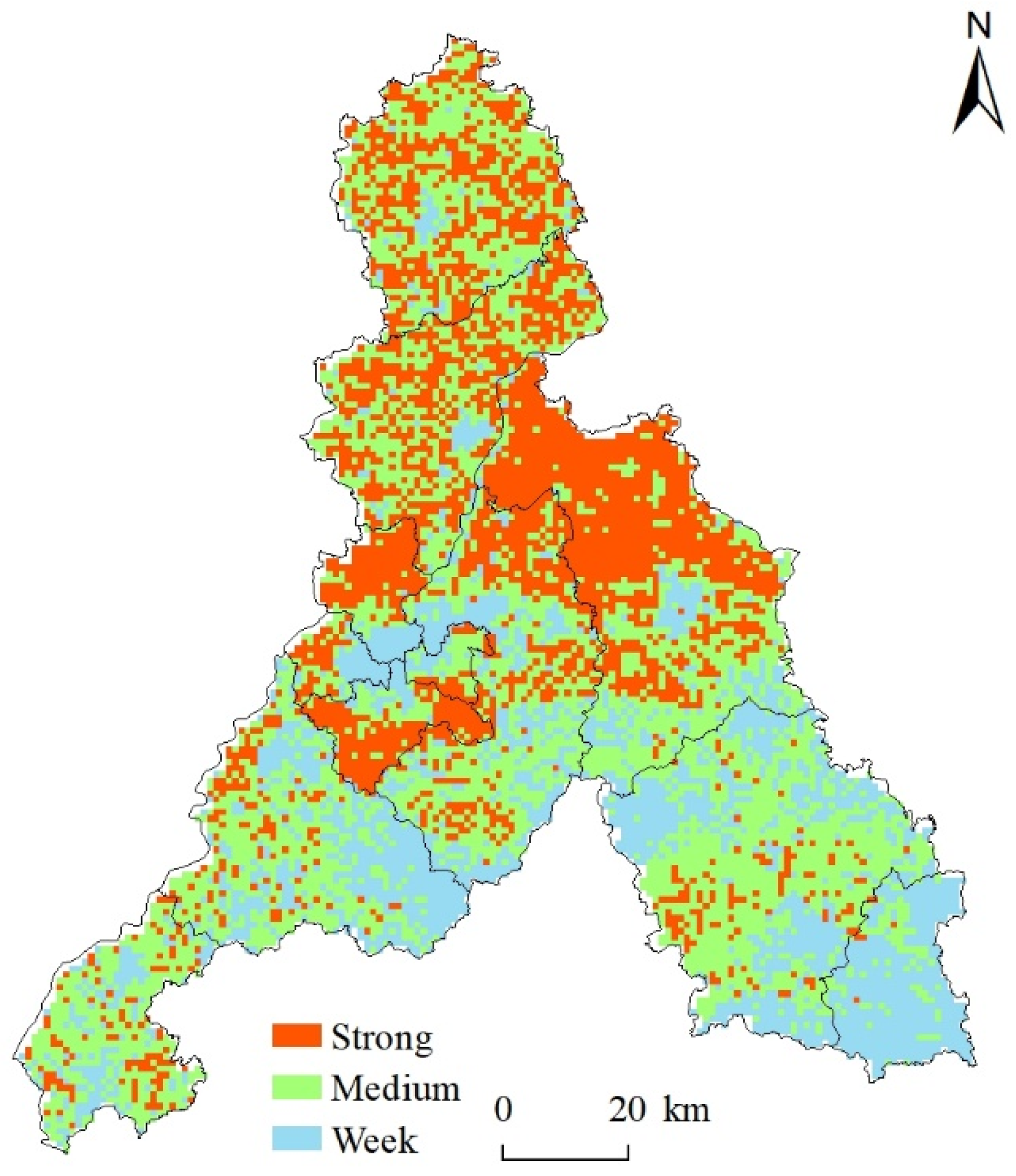
Land use conflicts in Jinan were dominated by medium conflicts (43.89%). Strong and weak land use conflicts accounted for 25.21% and 30.90%, respectively. The spatial distribution of land use conflicts differed, with high conflicts in the north and low conflicts in the south (
Figure 5). Strong land use conflicts are concentrated in the urban and rural transition zones of Tianqiao, Huaiyin and Shizhong districts, as well as in the northern parts of Licheng and Zhangqiu districts. Due to proximity to the urban area, land resource scarcity is higher in the urban–rural transition zone. The rapid urbanization process leads to a massive influx of people into cities and towns, sharply increasing the demand for construction land. Urban expansion and sprawl will inevitably give priority to the occupation of land resources in the urban–rural transition zone. Therefore, the contradiction and conflicts over land use in this region will intensify. This has been confirmed by previous research on urban expansion and sprawl [
29,
30].
Medium land use conflicts were mainly concentrated in Shanghe, Jiyang and Laiwu. Shanghe county and Jiyang district are in the North China Plain, which has flat terrain and fertile soils and is an important grain producing area. In summary, there are fewer factors restricting land use; thus, land use suitability is high. However, its urbanization level is relatively low and lacks cohesion and attraction to the population. In addition, these areas are dominated by migrant workers, and there is a certain degree of population loss, resulting in a large per capita cultivated land area, ranking them first and second in the per capita cultivated land area of Jinan. There is also a large per capita construction land scale, particularly in Jiyang district. Therefore, the diversity of human needs in Shanghe county and Jiyang district is not high, and land resource scarcity is low. Consequently, although Shanghe county and Jiyang district have high land use multi-suitability, the land resource scarcity is low and the diversity of human needs is not high, leading to a medium level of land use conflict. Laiwu district is surrounded by mountains to the north, east and south, with the Taishan mountains in the north and the Sorai Mountains in the south. It is gentle in the south and steep in the north, forming a semicircle basin protruding to the north. Due to limitations of topological factors, land use multi-suitability is medium in the basin and low in other areas. Laiwu district had a total population of 956,600 and a GDP of 59.351 billion yuan in 2018, with high diversity of human needs and medium land resource scarcity. The low land use multi-suitability, medium land resource scarcity and high diversity of human needs resulted in medium land use conflict in the district.
Weak land use conflicts are mainly distributed in the built-up areas of major towns, in the southern mountainous areas and in Gangcheng districts. The built-up areas are mostly made up of impervious surfaces and the possibility of converting them into cultivated or ecological land is very small. Therefore, the multi-suitability of the land is low. The main reasons for the weak land use conflicts in the southern mountainous area are the large topographic undulated area, frequent occurrence of geological disasters and inconvenient transportation. Gangcheng district is surrounded by mountains to the east, south and west; thus, the land use suitability is not high in most areas. The total population here is only 325,800, the GDP is 26.087 billion yuan, and the diversity of human needs and land resource scarcity is low. Therefore, land use conflict is weak.
5. Discussion
We designed a land use conflict identification framework based on land use multi-suitability, land resource scarcity and diversity of human needs, which can effectively and accurately identify land use conflicts. The areas with strong land use conflict are mainly distributed in the urban–rural transition zones, which is consistent with the results of previous studies [
31,
32]. However, we also find that the suburbs of cities and towns in the north of Licheng and Zhangqiu districts are also the areas where strong land use conflicts are concentrated. This is an interesting finding, which differs from previous studies. On the one hand, Jinan has implemented the "East Expansion" development strategy in recent years, and the urbanization process in eastern Jinan, including in Licheng and Zhangqiu districts, has advanced rapidly, and land use conflicts have intensified. On the other hand, the north of Licheng and Zhangqiu districts have flat terrains, low incidence of geological disasters, fewer land resource limiting factors, high land use suitability, large regional populations, large GDP and high diversity of land resource demand, resulting in a high intensity of land use conflict. However, it is worth noting that the per capita construction land area and per capita cultivated land area in these regions are both large, and land resource scarcity is low. There is a certain level of inefficient land use and even land resource waste, which aggravate regional land use conflicts.
The land use multi-suitability in Shanghe county and Jiyang district is high, but the intensity of land use conflict in most areas is not. This indicates that land use multi-suitability is the premise and basis of land use conflict, but it is not the only determinant. Even if land is suitable for multiple uses, it does not necessarily produce strong land use conflicts. Land use multi-suitability, land resource scarcity and diversity of human needs are three important determinants of land use conflicts, which together determine the occurrence and intensity of land use conflicts. However, previous studies focused only on the multi-suitability of, or competition over, land, and few studies have considered land use multi-suitability, land resource scarcity and human demand diversity simultaneously. In conclusion, compared with previous studies, the land use conflict identification framework constructed in this study has obvious advantages in the effective and accurate identification of land use conflicts.
The land use conflict identification and evaluation index system we have constructed here has the following advantages. First, the theoretical basis is sufficient. Using relevant studies and field research experience, we analyzed the root causes of land use conflicts and designed a conceptual framework for land use conflict identification. An evaluation index system for land use conflict identification was constructed by selecting evaluation indices from three variables: land use multi-suitability, land resource scarcity and diversity of human needs. Second, the land use conflict evaluation framework can identify the intensity of land use conflict on a grid scale, providing more accurate location information for land use decision making, hence contributing to the accurate land management.
Land use conflict arises from competing land uses. The theory of multifunctional land use can be used as a reference [
16,
33] and is based on the premise that the same parcel of land can have a dominant function while also having a variety of other functions. Based on the ecological service value trade-off/synergy theory and coupling coordination theory [
28,
34], the leading function should be rationally selected based on local conditions, and the tradeoff and coordination among different functions should be carried out to promote the coordinated development of multiple functions.
This study had some limitations. First, due to the limitation in the statistical unit of social and economic data, the evaluation unit of land resource scarcity and diversity of human needs was set at the county administrative division level and was not accurate to specific plots, reducing the accuracy of land use conflict identification. Second, this study evaluated the land use conflict in Jinan in 2018, but did not analyze the spatial–temporal evolution of the characteristics of land use conflicts. Finally, the ultimate purpose of land use conflict identification is to mediate land use conflicts. There are many more parameters (social, political, communicational, psychological, etc.) determining conflicts. Such a factor, e.g., is the ambiguity/unclearness of laws and policy contents [
35]. Another one could be redistributive policies, uncertainty, etc. This study only presented a superficial discussion on the topic, and further research is needed. Therefore, future research should focus on using grid scale social and economic data to quantitatively evaluate the spatiotemporal dynamic characteristics of land use conflicts and to explore effective measures to resolve land use conflicts.


