Geographic Information Systems and the Sustainable Development of Rural Areas

 ,
,  ,
,  ,
,  and
and 
Abstract
1. Introduction
2. Materials and Methods
2.1. Area and Object of Study
2.2. Sources and Scope of Data
2.3. Key Assumptions and Research Objectives
- The rational distribution of human activities based on local conditions and the influence of external factors is the mainstay of sustainable development.
- Sustainable development of rural areas is a conscious transformation process during which human needs must be aligned with the needs of the natural environment.
- Sustainable (permanent and multifunctional) development of rural areas requires effective legal, economic, administrative, and technical instruments.
- Geographic information systems and GIS tools support rapid and comprehensive analyses of spatial and environmental phenomena and are useful in the process of generating development forecasts and planning the sustainable development of rural areas.
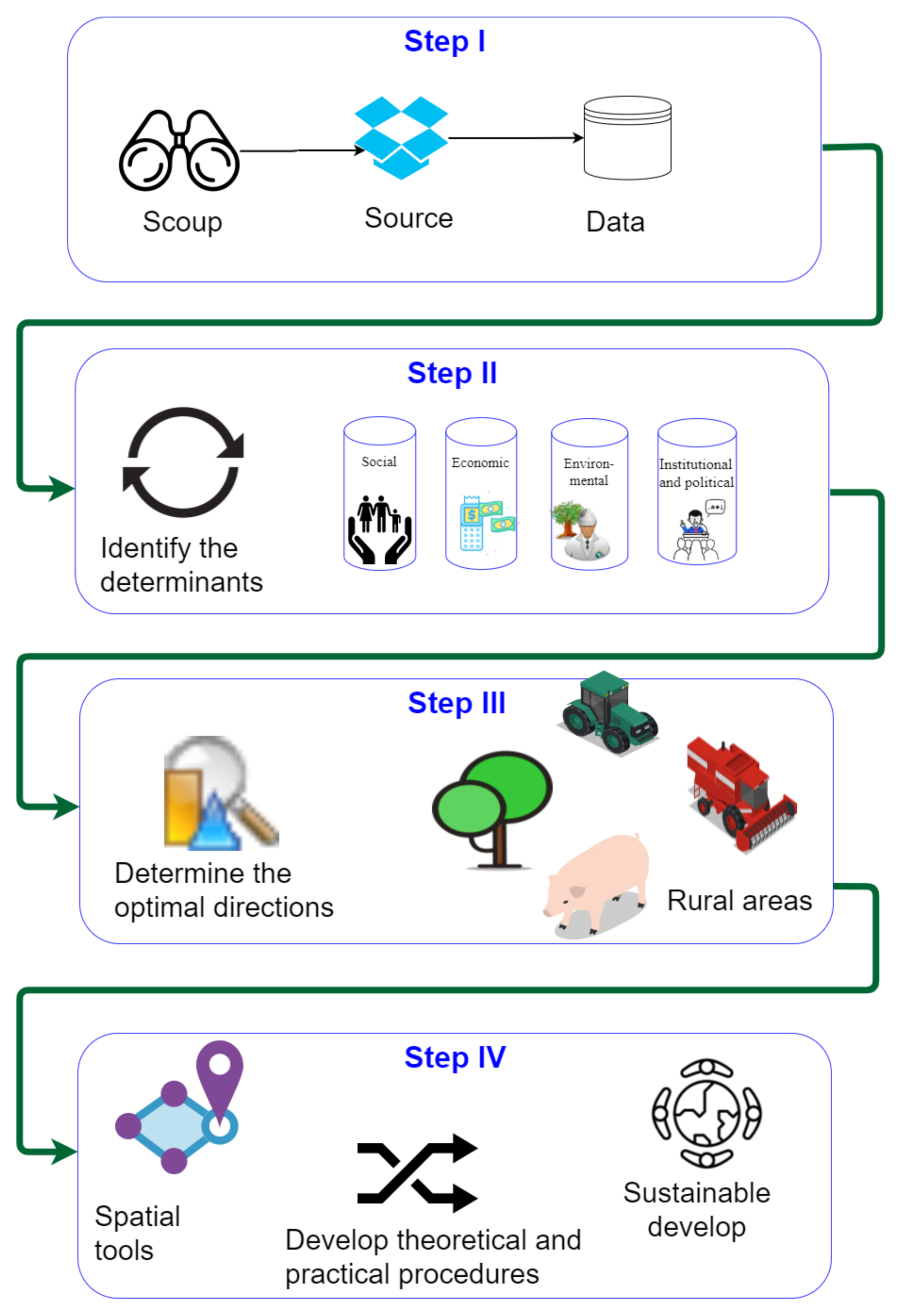
- To determine the scope, sources, and applicability of data for spatial analyses of phenomena relating to sustainable development.
- To identify the determinants of rural development in view of the main pillars of sustainable development.
- To determine the optimal directions of sustainable development in rural areas.
- To propose a practical approach for the use of spatial tools, methods, and analyses and to develop theoretical and practical procedures for the sustainable development of rural areas.
3. Results and Discussion
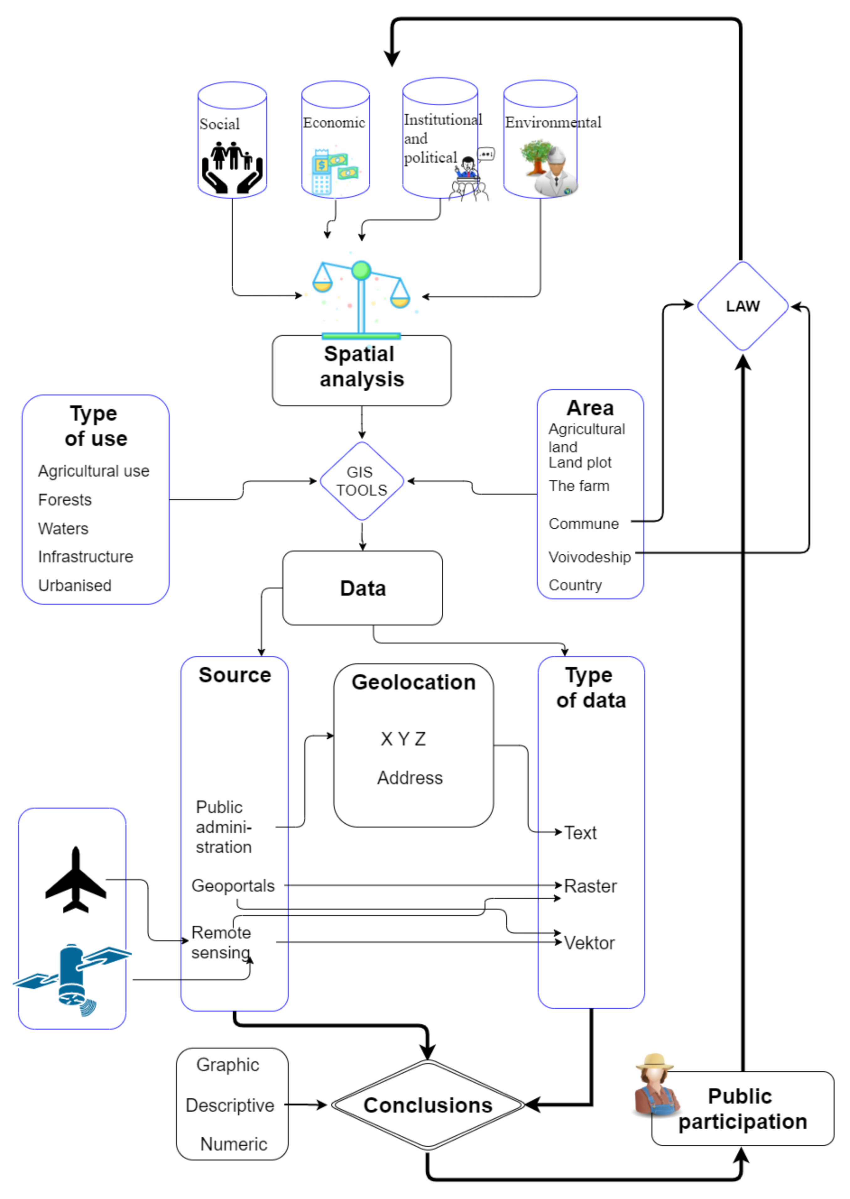
3.1. Determination of the Scope, Sources, and Applicability of Data for Spatial Analyses
3.2. Identification of the Main Determinants of Rural Development in View of the Pillars of Sustainable Development
3.3. Determination of the Optimal Directions of Sustainable Development in Rural Areas
3.4. Practical Application of the Applied Tools and Methods of Spatial Analysis and the Development of Theoretical and Practical Procedures for Sustainable Development of Rural Areas
4. Conclusions
- The informative and functional value of source data was determined in view of the aim, scope, and time framework of spatial analyses.
- The main determinants of sustainable development were identified and indicators for monitoring sustainable development measures were proposed.
- The optimal directions of sustainable development were identified in view of changing external circumstances, including legal, social, and economic.
- The applicability of GIS tools as instruments that support vital decision-making processes in the implementation of sustainable development principles was discussed.
- Preparing planning studies, both regarding spatial policy and local law, as well as in economic planning and shaping the structure of rural space (structure of ownership and structure of use).
- The development of thematic spatial information systems related to planning studies and works shaping the rural space.
- Reports submitted to Polish and EU authorities relating to the utilization of funds dedicated to rural development in the multiannual financial framework and modification of the implemented actions.
- The use of renewable energy sources to improve Poland’s energy security.
Author Contributions
Funding
Institutional Review Board Statement
Informed Consent Statement
Data Availability Statement
Acknowledgments
Conflicts of Interest
References
- Łuszczyk, M. Koncepcja rozwoju zrównoważonego w polityce ekologicznej państwa. In Ekologiczne Problemy Zrównoważonego Rozwoju; Kiełczewski, D., Dobrzańska, B., Eds.; Wydawnictwo Wyższej Szkoły Ekonomicznej w Białymstoku: Warszawa, Poland, 2009; pp. 49–60. [Google Scholar]
- Redclift, M. Sustainable development (1987–2005): An oxymoron comes of age. Sustain. Dev. 2005, 13, 212–227. [Google Scholar] [CrossRef]
- World Commission on Environment and Development & Brundtland Commission. Our Common Future, Brundtland Report. In Proceedings of the Report of the World Commission on Environment and Development to the Commission of the European Communities, the EC and EFTA Countries, Brussels, Belgium, 5 May 1987; World Commission on Environment and Development: Brussels, Belgium, 1987. [Google Scholar]
- Act on Environmental Protection and Management of 31 January 1980. J. Laws 1994, 49, 196.
- Act on Environmental Protection Law of 27 April 2001. J. Laws 2020, 1219.
- Constitution of the Republic of Poland of 7 April 1997. J. Laws 1997, 78, 483.
- Hopwood, B.; Mellor, M.; O’Brien, G. Sustainable development: Mapping different approaches. Sustain. Dev. 2005, 13, 38–52. [Google Scholar] [CrossRef]
- Marks-Bielska, R. Chosen aspects of sustainable development in Poland with particular focus on agriculture. In Management Theory and Studies for Rural Business and Infrastructure Development; 2. Research Papers; Lithuanian University of Agriculture: Kaunas, Lithuania, 2011. [Google Scholar]
- Pretty, J.N. Participatory learning for sustainable agriculture. World Dev. 1995, 23, 1247–1263. [Google Scholar] [CrossRef]
- Reganold, J.P.; Papendick, R.I.; Parr, J.F. Sustainable agriculture. Sci. Am. 1990, 262, 112–121. [Google Scholar] [CrossRef]
- DeLonge, M.S.; Miles, A.; Carlisle, L. Investing in the transition to sustainable agriculture. Environ. Sci. Policy 2016, 55, 266–273. [Google Scholar] [CrossRef]
- McCormick, K.; Anderberg, S.; Coenen, L.; Neij, L. Advancing sustainable urban transformation. J. Clean. Prod. 2013, 50, 1–11. [Google Scholar] [CrossRef]
- Shen, L.; Zhou, J. Examining the effectiveness of indicators for guiding sustainable urbanization in China. Habitat Int. 2014, 44, 111–120. [Google Scholar] [CrossRef]
- Shen, L.; Shuai, C.; Jiao, L.; Tan, Y.; Song, X. A global perspective on the sustainable performance of urbanization. Sustainability 2016, 8, 783. [Google Scholar] [CrossRef]
- Satterthwaite, D. Sustainable cities or cities that contribute to sustainable development? Urban. Stud. 1997, 34, 1667–1691. [Google Scholar] [CrossRef]
- Bibri, S.E.; Krogstie, J. Smart sustainable cities of the future: An extensive interdisciplinary literature review. Sustain. Cities Soc. 2017, 31, 183–212. [Google Scholar] [CrossRef]
- Hunter, C. Sustainable tourism as an adaptive paradigm. Ann. Tour. Res. 1997, 24, 850–867. [Google Scholar] [CrossRef]
- Buckley, R. Sustainable tourism: Research and reality. Ann. Tour. Res. 2012, 39, 528–546. [Google Scholar] [CrossRef]
- Dempsey, N.; Bramley, G.; Power, S.; Brown, C. The social dimension of sustainable development: Defining urban social sustainability. Sustain. Develop. 2011, 19, 289–300. [Google Scholar] [CrossRef]
- Murphy, K. The social pillar of sustainable development: A literature review and framework for policy analysis. Sustain. Sci. Pract. Policy 2012, 8, 15–29. [Google Scholar] [CrossRef]
- Eizenberg, E.; Jabareen, Y. Social sustainability: A new conceptual framework. Sustainability 2017, 9, 68. [Google Scholar] [CrossRef]
- Missimer, M.; Robèrt, K.H.; Broman, G. A strategic approach to social sustainability–Part 1: Exploring the social system. J. Clean. Prod. 2017, 140, 32–41. [Google Scholar] [CrossRef]
- Daly, H.E. Ecological Economics and Sustainable Development; Edward Elgar Publishing: Cheltenham, UK, 2007. [Google Scholar]
- Lawn, P.A. Toward Sustainable Development: An Ecological Economics Approach; CRC Press: Boca Raton, FL, USA, 2000. [Google Scholar]
- Czaja, S.; Becla, A. Wybrane informacyjne problemy definiowania zrównoważonego i trwałego rozwoju–ujęcie teoretyczne. [Selected information problems of defining sustainable development: A theoretical analysis]. Optimum. Studia Ekonomiczne 2016, 1. [Google Scholar] [CrossRef]
- Wskaźniki rozwoju zrównoważonego Polski [Sustainable development indicators]; GUS: Katowice, Poland, 2011; ISBN 978-83-89641-04-5.
- Wskaźniki rozwoju zrównoważonego [Sustainable development indicators]; GUS: Katowice, Poland, 2015; ISBN 978-83-89641-54-0.
- Alexander, E.R. Institutional design for sustainable development. Town Plan. Rev. 2006, 77, 1–27. [Google Scholar] [CrossRef]
- Rahman, H.M.; Saint Ville, A.; Song, A.; Po, J.; Berthet, E.; Brammer, J.; Reed, G. A framework for analyzing institutional gaps in natural resource governance. Int. J. Commons 2017, 11. [Google Scholar] [CrossRef]
- MombeuiL, C. Institutional conditions, sustainable energy, and the UN sustainable development discourse: A focus on Haiti. J. Clean. Prod. 2020, 254, 120153. [Google Scholar] [CrossRef]
- Kryszk, H.; Kurowska, K.; Brodziński, Z. Identification of renewable energy sources in the region of Warmia and Mazury with the use of mapinfo professional software. In GIS and its Implementations; Źróbek, R., Kereković, D., Eds.; Croatian Information Technology Society, GIS Forum: Zagreb, Croatia, 2013; pp. 136–148. [Google Scholar]
- Kryszk, H.; Kurowska, K. Photovoltaics as a source of renewable energy and a new area of activity in rural areas. Studia Obsz. Wiej. 2014, 35, 255–272. [Google Scholar]
- Kurowska, K.; Kryszk, H. The use of funds for agri-environmental measures in the Warmińsko-Mazurskie Voivodship in 2007–2013. Studia Obszarów Wiejskich 2013, 34, 205–220. [Google Scholar]
- Kurowska, K.; Kryszk, H.; Marks-Bielska, R.; Kietlińska, E. Spatial analysis of afforestation in Poland under rural development programme 2007–2013. In Proceedings of the Annual 20th International Scientific Confference Proceedings Research for Rural Development 2014, Jelgava, Latvia, 21–23 May 2014. [Google Scholar]
- Kurowska, K.; Kryszk, H.; Gwiaździńska-Goraj, M. Sustainable development of coastal areas-Polish experience following accession to the European Union based on the example of Fisheries Local Action Groups (FLAGs) during 2007–2013. Acta Adriatica 2014, 55, 163–178. [Google Scholar]
- Kurowska, K.; Rudnicki, R. Changes in land use in Poland—Comparative study of period 2002–2010. In Proceedings of the The 7th International Scientific Conference Rural Development 2015: Towards the Transfer of Knowledge, Innovations and Social Progress, Kaunas, Lithuania, 9–20 November 2015. [Google Scholar] [CrossRef]
- Kurowska, K.; Kryszk, H. Profitability of the farmland afforestation within the Rural Development Programme. Sylwan 2017, 161, 1035–1045. [Google Scholar]
- Jeżowski, P. Kategoria rozwoju zrównoważonego w naukach ekonomicznych. In Ekonomiczne Problemy Ochrony Środowiska I Rozwoju Zrównoważonego W XXI Wieku; Jeżowski, P., Ed.; Oficyna Wydawnicza Szkoły Głównej Handlowej: Warszawa, Poland, 2007. [Google Scholar]
- Mitchell, G. Problems and fundamentals of sustainable development indicators. Sustain. Dev. 1996, 4, 1–11. [Google Scholar] [CrossRef]
- Tasaki, T.; Kameyama, Y.; Hashimoto, S.; Moriguchi, Y.; Harasawa, H. A survey of national sustainable development indicators. Int. J. Sustain. Dev. 2010, 13, 337–361. [Google Scholar] [CrossRef]
- Borys, T. (Ed.) Wskaźniki Ekorozwoju; Wydawnictwo Ekonomia i Środowisko: Białystok, Poland, 1999. [Google Scholar]
- Alexander, E.R.; Mazza, L.; Moroni, S. Planning without plans? Nomocracy or teleocracy for social-spatial ordering. Prog. Plan. 2012, 77, 37–87. [Google Scholar] [CrossRef]
- Podciborski, T.; Krzywnicka, I. A method for evaluating the peripherality of rural settlement units based on the principles of spatial order and sustainable development. Barometr Regionalny. Analizy i prognozy 2015, 1, 27–32. [Google Scholar]
- Różycka-Czas, R.; Salata, T.; Gawroński, K.; Czesak, B.; Cegielska, K. The use of geographic information systems to spatial order evaluation. Acta Sci. Pol. Form. Circumiectus 2016, 15, 73. [Google Scholar] [CrossRef]
- Bina, O. The green economy and sustainable development: An uneasy balance? Environ. Plan. C Gov. Policy 2013, 31, 1023–1047. [Google Scholar] [CrossRef]
- Aldieri, L.; Vinci, C.P. Green economy and sustainable development: The economic impact of innovation on employment. Sustainability 2018, 10, 3541. [Google Scholar] [CrossRef]
- Lavrinenko, O.; Ignatjeva, S.; Ohotina, A.; Rybalkin, O.; Lazdans, D. The role of green economy in sustainable development (case study: The EU states). Entrep. Sustain. Issues 2019, 6, 1013–1026. Available online: https://jssidoi.org/jesi/article/273 (accessed on 7 September 2020). [CrossRef]
- Janoušková, S.; Hák, T.; Moldan, B. Global SDGs assessments: Helping or confusing indicators? Sustainability 2018, 10, 1540. [Google Scholar] [CrossRef]
- Cloke, P.J.; Doel, M.A.; Matless, D.; Thrift, N.; Phillips, M. Writing the Rural: Five Cultural Geographies; Sage: London, UK, 1994. [Google Scholar]
- Cloke, P.J. (Ed.) Country Visions; Pearson Education: New York, NY, USA, 2003. [Google Scholar]
- Coburn, A.F.; MacKinney, A.C.; McBride, T.D.; Mueller, K.J.; Slifkin, R.T.; Wakefield, M.K. Choosing rural definitions: Implications for health policy. Rural Policy Res. Inst. Health Panel 2007, 2, 1–8. [Google Scholar]
- Ilbery, B. Dimensions of rural change. In The Geography of Rural Change; Ilbery, B., Ed.; Routledge: London, UK, 1998; pp. 1–10. [Google Scholar]
- Bański, J.; Mazur, M. Classification of rural areas in Poland as an instrument of territorial policy. Land Use Policy 2016, 54, 1–17. [Google Scholar] [CrossRef]
- Lanfranchi, M.; Giannetto, C. Sustainable development in rural areas: The new model of social farming. Calitatea 2014, 15 (Suppl. S1), 219. [Google Scholar]
- Bansal, V.K. Use of geographic information systems in spatial planning: A case study of an institute campus. J. Comput. Civil Eng. 2014, 28, 05014002. [Google Scholar] [CrossRef]
- Linsenbarth, A.; Ney, B.; Wysocka, E. Concept of the Polish spatial information system. In Proceedings of the 7th EC GI&GIS Workshop, Potsdam, Germany, 13–15 June 2001. [Google Scholar]
- Directive INSPIRE 2007/2/EC of European Parliament and the Council of 14 March 2007 Establishing an Infrastructure for Spatial Information in the European Community; European Commission: Brussels, Belgium, 2007.
- Council Regulation (EC). No. 1198/2006 of 27 July 2006 on the European Fisheries Fund; European Commission: Brussels, Belgium, 2006.
- Brodziński, Z.; Kryszk, H.; Kurowska, K. Market of producers and processors of agricultural biomass for energy purposes. Pol. J. Environ. Stud. 2014, 23, 619–628. [Google Scholar]
- Kurowska, K.; Kryszk, H.; Bielski, S. Determinants of biomass production for energy purposes in North-Eastern Poland. In Proceedings of the 13th International Scientific Conference on Engineering for Rural Development, Jelgava, Łotwa, 29–30 May 2014; pp. 417–422. [Google Scholar]
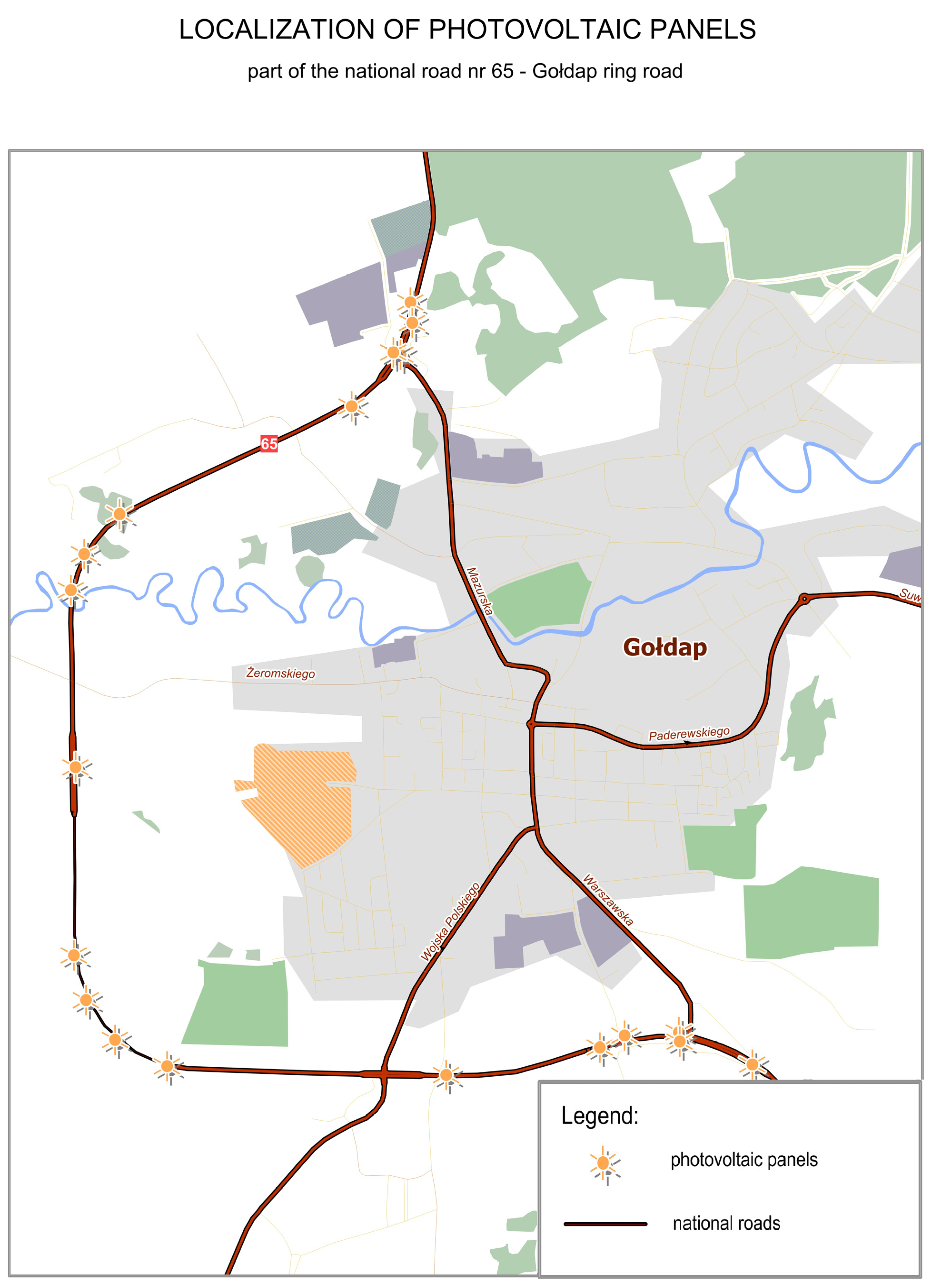
- Kurowska, K.; Kryszk, H.; Kietlińska, E. Photovoltaics as an element of intelligent transport system development. In Geoinformatics for Intelligent Transportation; Springer: Cham, Switzerland, 2015; pp. 187–199. [Google Scholar] [CrossRef]
- Bibby, P.; Shepherd, J. GIS, land use, and representation. Environ. Plan. B Plan. Des. 2000, 27, 583–598. [Google Scholar] [CrossRef]
- Brzuchowska, J. Proposals of transportation phenomena analysis based on raster maps and GIS tools. Tech. Trans. 2010, 3, 125–138. [Google Scholar]
- Van Iseghem, S.; Quillérou, E.; Brigaudeau, C.; Macher, C.; Guyader, O.; Daurès, F. Ensuring representative economic data: Survey data-collection methods in France for implementing the Common Fisheries Policy. ICES J. Mar. Sci. 2011, 68, 1792–1799. [Google Scholar] [CrossRef]
- Waheed, R.; Chang, D.; Sarwar, S.; Chen, W. Forest, agriculture, renewable energy, and CO2 emission. J. Clean. Prod. 2018, 172, 4231–4238. [Google Scholar] [CrossRef]
- Chel, A.; Kaushik, G. Renewable energy for sustainable agriculture. Agron. Sustain. Dev. 2011, 31, 91–118. [Google Scholar] [CrossRef]
- Fan, Y.; Lee, A.; Parker, N.; Scheitrum, D.; Dominguez-Faus, R.; Jaffe, A.M.; Medlock III, K. Geospatial, temporal and economic analysis of alternative fuel infrastructure: The case of freight and US natural gas markets. Energy J. 2017, 38. [Google Scholar] [CrossRef]
- Romański, L.; Bukowski, P.; Dębowski, M. Analysis of using renewable energy in rural farms. Agric. Eng. 2012, 2, 137. [Google Scholar]
- Stolarski, M. Prospects for the use of renewable energy sources. In Current Status and Prospects of Development of Rural Areas in the Warmia-Mazury 2020; Brodziński, Z., Ed.; Samorząd Województwa Warmińsko-Mazurskiego: Olsztyn, Poland, 2012; pp. 79–98. (In Polish) [Google Scholar]
- Noon, C.E.; Daly, M.J. GIS-based biomass resource assessment with BRAVO. Biomass Bioenergy 1996, 10, 101–109. [Google Scholar] [CrossRef]
- Fiorese, G.; Guariso, G. A GIS-based approach to evaluate biomass potential from energy crops at regional scale. Environ. Model. Softw. 2010, 25, 702–711. [Google Scholar] [CrossRef]
- Jasiulewicz, M. Possibility of liquid bio-fuels, electric and heat energy production from biomass in polish agriculture. Pol. J. Environ. Stud. 2010, 19, 480. [Google Scholar]
- Jezierska-Thöle, A.; Rudnicki, R.; Kluba, M. Development of energy crops cultivation for biomass production in Poland. Renew. Sustain. Energy Rev. 2016, 62, 534–545. [Google Scholar] [CrossRef]
- Hauk, S.; Knoke, T.; Wittkopf, S. Economic evaluation of short rotation coppice systems for energy from biomass—A review. Renew. Sustain. Energy Rev. 2014, 29, 435–448. [Google Scholar] [CrossRef]
- Testa, R.; Di Trapani, A.M.; Foderà, M.; Sgroi, F.; Tudisca, S. Economic evaluation of introduction of poplar as biomass crop in Italy. Renew. Sustain. Energy Rev. 2014, 38, 775–780. [Google Scholar] [CrossRef]
- Falkowski, J.; Kostrowicki, J. Geografia Rolnictwa Świata [Geography of Agriculture in the World]; PWN: Warszawa, Poland, 2001. [Google Scholar]
- Uhorczak, F. Użytkowanie ziemi i rolnictwo [Land use and agriculture]. In Geografia Powszechna; Barbag, J., Ed.; PWN: Warszawa, Poland, 1963; p. 268. 2012. [Google Scholar]
- Łowicki, D. Land use changes in Poland during transformation: Case study of Wielkopolska region. Landsc. Urban Plan. 2008, 87, 279–288. [Google Scholar] [CrossRef]
- Kulikowski, R. Zmiany w kierunkach użytkowania gruntów ornych w Polsce w latach 1958–1965, Przegląd Geograficzny [Changes in trends of arable land use in Poland in 1958–1965]. Geogr. Rev. 1969, 41, 2. [Google Scholar]
- Bański, J. Przemiany Rolniczego Użytkowania Ziemi w Polsce w Latach 1975–1988, Prace Geograficzne, [Changes in Agricultural Land Use in Poland in 1975–1988, Geographical Studies]; IGiPZ PAN: Warszawa, Poland, 1997; p. 168. [Google Scholar]
- Cegielska, K.; Noszczyk, T.; Kukulska, A.; Szylar, M.; Hernik, J.; Dixon-Gough, R.; Kovács, K.F. Land use and land cover changes in post-socialist countries: Some observations from Hungary and Poland. Land Use Policy 2018, 78, 1–18. [Google Scholar] [CrossRef]
- Noszczyk, T. Land use change monitoring as a task of local government administration in Poland. J. Ecol. Eng. 2018, 19, 170–176. [Google Scholar] [CrossRef]
- Kiryluk-Dryjska, E.; Beba, P.; Poczta, W. Local determinants of the Common Agricultural Policy rural development funds’ distribution in Poland and their spatial implications. J. Rural Stud. 2020, 74, 201–209. [Google Scholar] [CrossRef]
- Kołodziejczak, A.; Rudnicki, R. Common Agricultural Policy instruments aiming at improvement of natural environment in the context of spatial planning in agriculture. Acta Sci. Polonorum. Adm. Locorum 2012, 11, 117–133. [Google Scholar]
- Update of the National Program for Increasing Woodness; Ministry of the Environment: Warsaw, Poland, 2003.
- Marks-Bielska, R.; Bielski, S. The increasing role of agriculture to ensure national energy security. Wies i Rolnictwo 2013, 4, 149–160. [Google Scholar]
- Kulikowski, R. Produkcja i towarowość rolnictwa w Polsce. Przemiany i zróżnicowanie przestrzenne po II wojnie światowej, Prace Geograficzne [Agricultural production and market ability in Poland. Changes and spatial diversification after World War II.]. Geogr. Stud. 2013, 241, 122. [Google Scholar]
- Ziętara, W. Model of Polish agriculture—In the face of current challenges. Zesz. Nauk. Sggw. Ekon. I Organ. 2009, 73, 5–21. [Google Scholar]


| Pillar of Sustainable Development | Determinants |
|---|---|
| Barriers/Negative Factors | |
| Social | Low levels of awareness relating to the significance: |
| noneconomic functions of local associations | |
| develop of renewable energy sources and photovoltaic systems | |
| noneconomic functions of forests | |
| Rapid urbanization | |
| Economic | Production limits in sea fisheries and lower employment in the fisheries sector |
| Barriers to business growth (unstable market of farming supplies and agricultural produce) | |
| Economic factors are the main drivers of business growth (production) | |
| Environmental | Environmental degradation |
| Loss of land used in agricultural production | |
| Intensification of production | |
| Institutional and political | Legal instability (frequent changes in legal regulations) |
| Differences in the operating principles of FLAGs and the resulting interpretation problems | |
| Frequent changes in the Local Development Strategies of Fisheries | |
| Lack of programs to support renewable energy | |
| Ineffective management of the CAP budget | |
| Absence of renewable energy support programs | |
| Changes in the CAP principles | |
| Lack of stable legal basis | |
| Opportunities/Positive Factors | |
| Social | Higher standard of living |
| Promoting the concept of sustainable development | |
| Development of services and higher service quality | |
| Development of social capital | |
| Activation of local communities | |
| Improved road traffic safety | |
| Economic | Additional source of income for rural residents |
| New employment opportunities outside the fisheries sector | |
| Diversification of agricultural production | |
| Financial support under the CAP | |
| Management of surplus production and agricultural wastes | |
| Energy security | |
| Environmental | Protection of natural resources |
| Improved quality of the natural environment, including water quality | |
| Promotion of environmentally friendly solutions (renewable energy) | |
| Slowing down the exploitation of natural resources and minimizing pollution | |
| Higher forest cover | |
| Institutional and political | Financial support for technological development Goal performance based on development strategies Involvement of local partners in decision-making Public-private partnership |
Publisher’s Note: MDPI stays neutral with regard to jurisdictional claims in published maps and institutional affiliations. |
© 2020 by the authors. Licensee MDPI, Basel, Switzerland. This article is an open access article distributed under the terms and conditions of the Creative Commons Attribution (CC BY) license (http://creativecommons.org/licenses/by/4.0/).
Share and Cite
Kurowska, K.; Marks-Bielska, R.; Bielski, S.; Aleknavičius, A.; Kowalczyk, C. Geographic Information Systems and the Sustainable Development of Rural Areas. Land 2021, 10, 6. https://doi.org/10.3390/land10010006
Kurowska K, Marks-Bielska R, Bielski S, Aleknavičius A, Kowalczyk C. Geographic Information Systems and the Sustainable Development of Rural Areas. Land. 2021; 10(1):6. https://doi.org/10.3390/land10010006
Chicago/Turabian StyleKurowska, Krystyna, Renata Marks-Bielska, Stanisław Bielski, Audrius Aleknavičius, and Cezary Kowalczyk. 2021. "Geographic Information Systems and the Sustainable Development of Rural Areas" Land 10, no. 1: 6. https://doi.org/10.3390/land10010006
APA StyleKurowska, K., Marks-Bielska, R., Bielski, S., Aleknavičius, A., & Kowalczyk, C. (2021). Geographic Information Systems and the Sustainable Development of Rural Areas. Land, 10(1), 6. https://doi.org/10.3390/land10010006