Cultural Ecosystem Services in the Natura 2000 Network: Introducing Proxy Indicators and Conflict Risk in Greece

 , ,
, , 
Abstract
1. Introduction
2. Materials and Methods
2.1. The Protected Area System
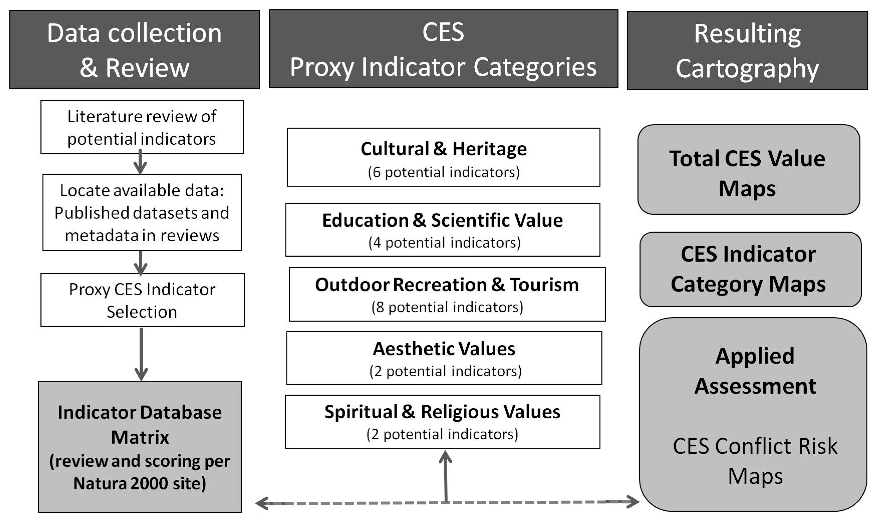
2.2. Preparatory Actions and CES Indicator Selection
- Compilation of data and GIS map layers pertaining to the Natura sites in Greece: using the Natura 2000 Standard Data Forms and monitoring results [60] and spatial data for habitat types following the European Environment Agency (EEA) guidelines [61]; a detailed ecosystem-type mapping for Greece is an ongoing procedure of the LIFE-IP 4 NATURA project [43].
- Protected-area cultural attributes data matrix and associated metadata pertaining to Natura 2000 “culturalness” developed by Vlami and colleagues in 2017 [62].
- Exploration of data availability and quality with respect to the state-wide relevance of national indicators for MAES applications based on the review by Dimopoulos and colleagues in 2017 [44] and on datasets freely available by state authorities (links provided in Kokkoris and colleagues in 2020 [43]).
- Selection and review of indicators responsive to policy and conservation management needs: using the guidance provided by Maes and colleagues [63,64] and in combination with the targets of the Greek Biodiversity Strategy [65]; each indicator was examined for policy relevance and related to the Common International Classification for Ecosystem Services (CICES) [66].
- Initial assessment of potential indicators: using a simple scaling method, based on van Oudenhoven [67], pertaining to salience, credibility, legitimacy and feasibility. Each potential CES indicator was scored by the co-authors as: 1—very low, 2—low, 3—medium, 4—high, 5—ready for use. This overview of uncertainty of use allowed the co-authors to decide on a final selection of potential indicators and to explore uncertainty and applicability issues. This screening of indicators is identical to building the national MAES indicators [43].
2.3. Database and Mapping Applications
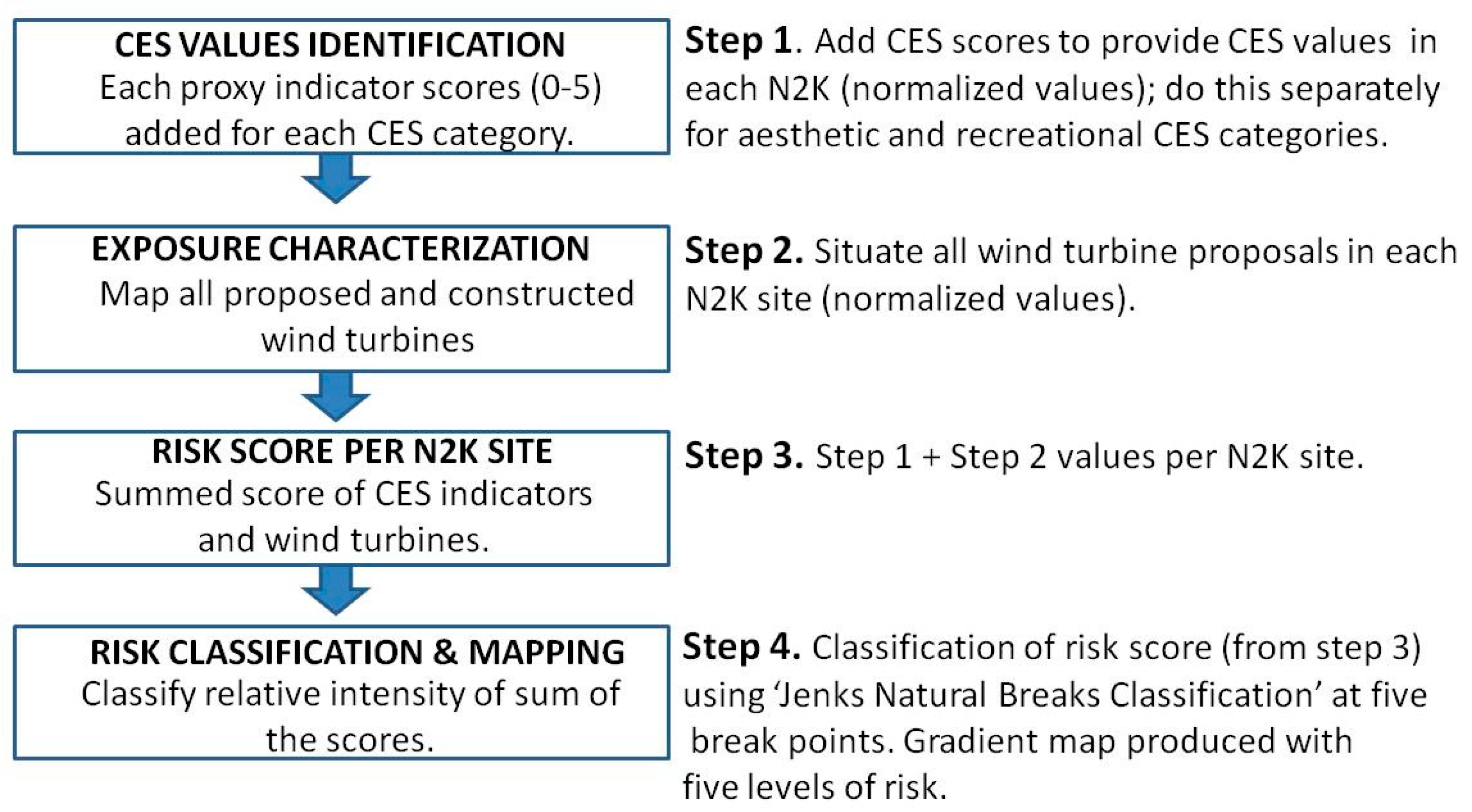
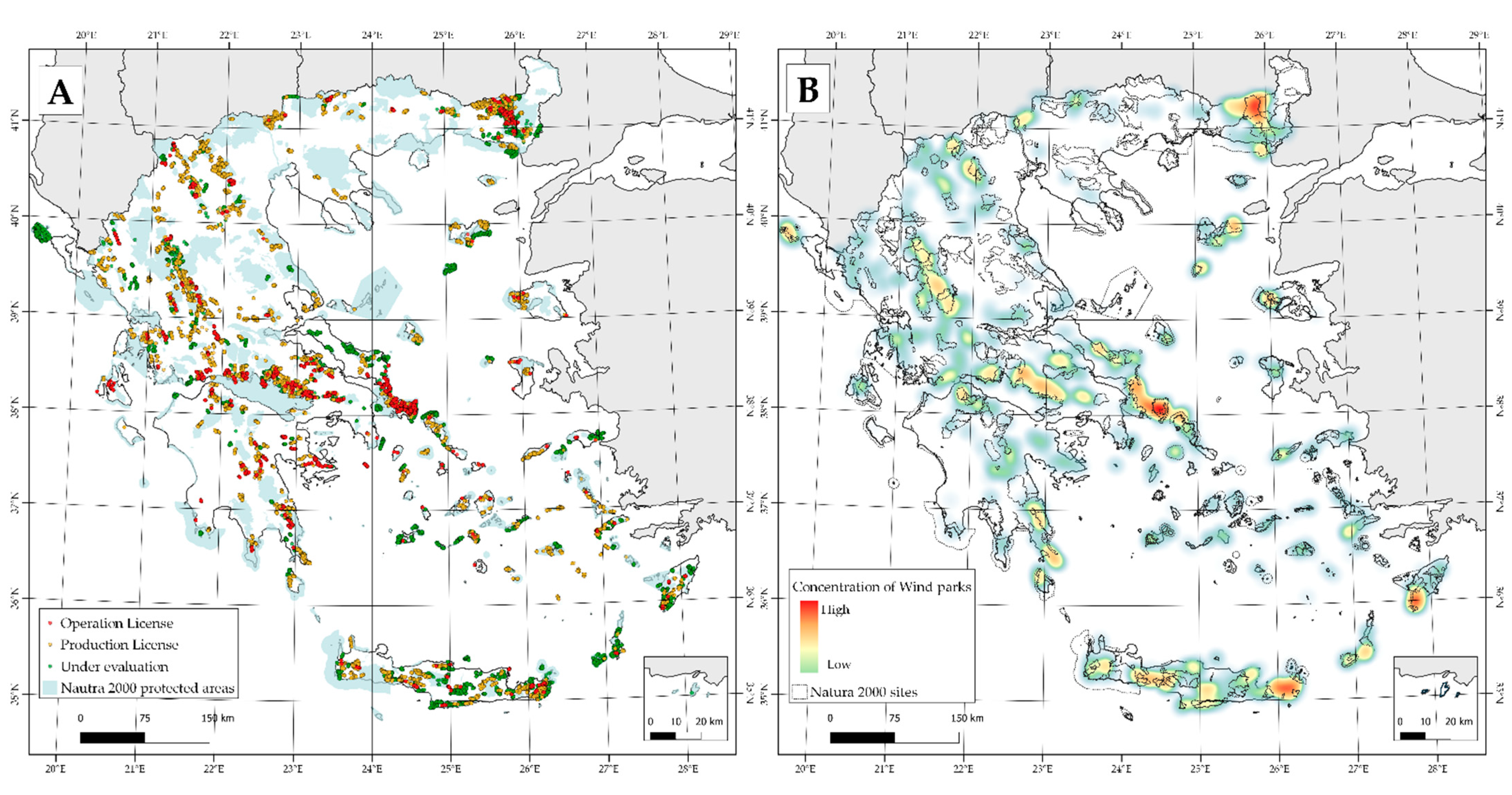
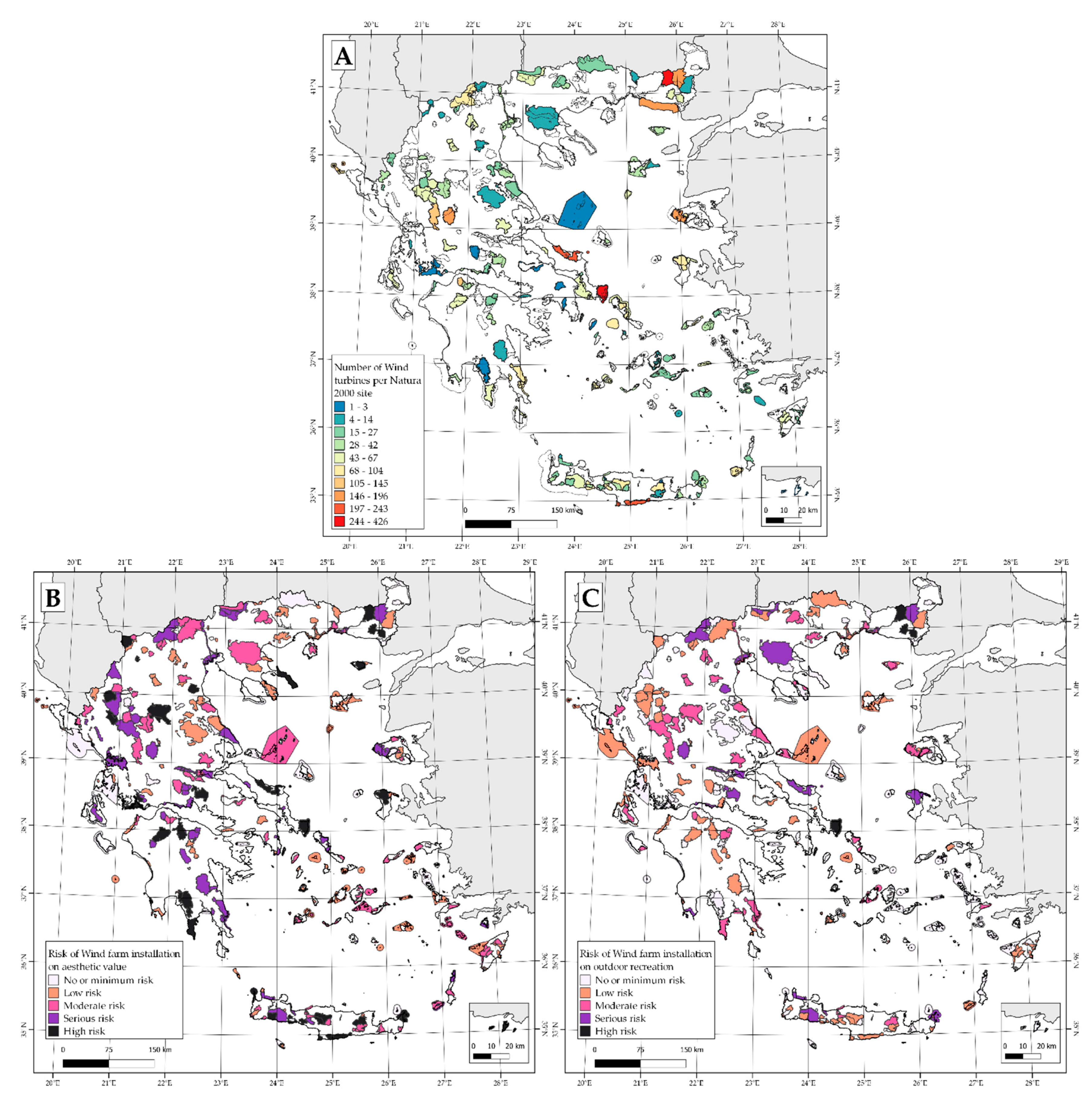
2.4. Wind Farm Conflict Risk Mapping Exercise
3. Results
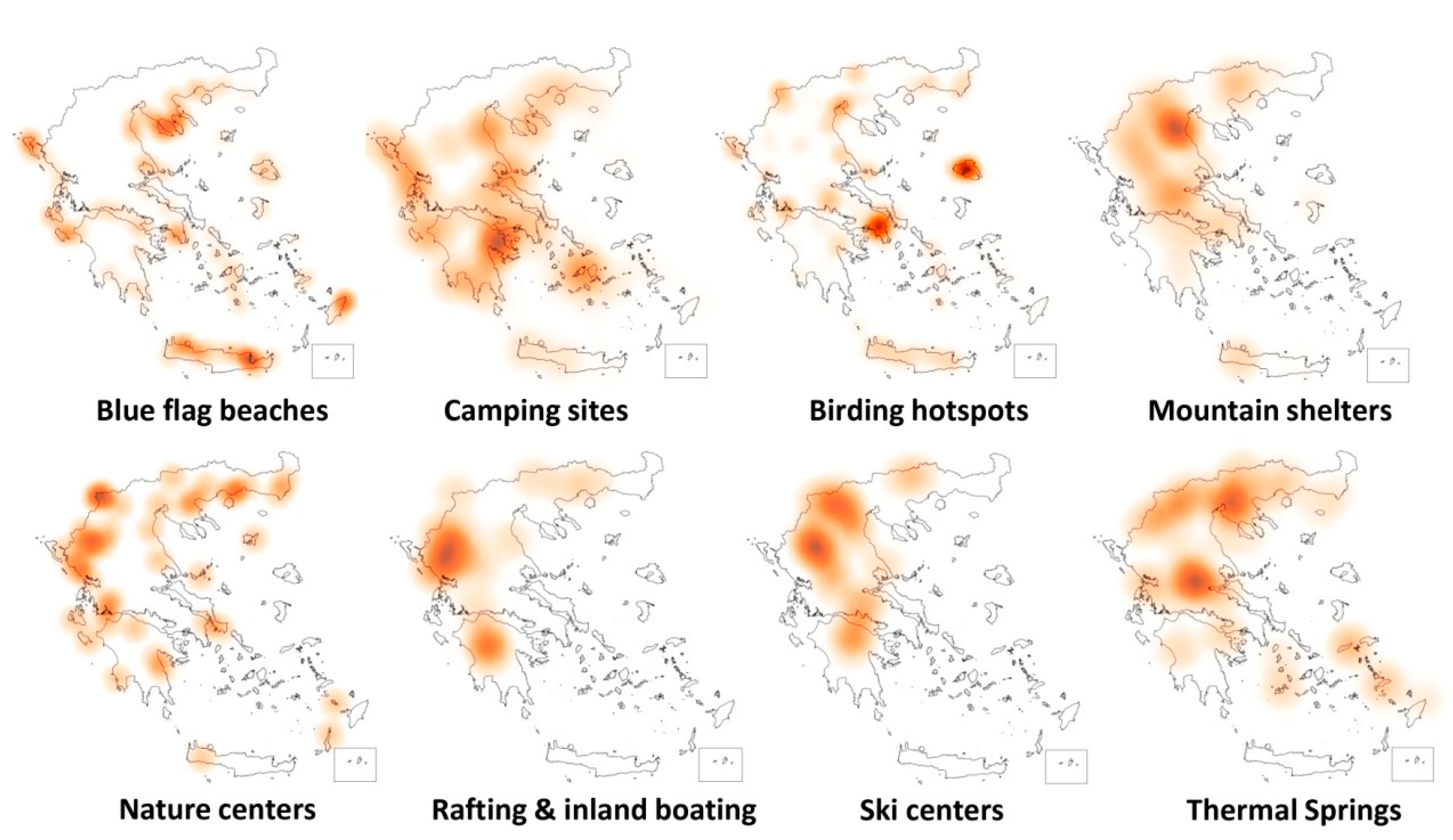
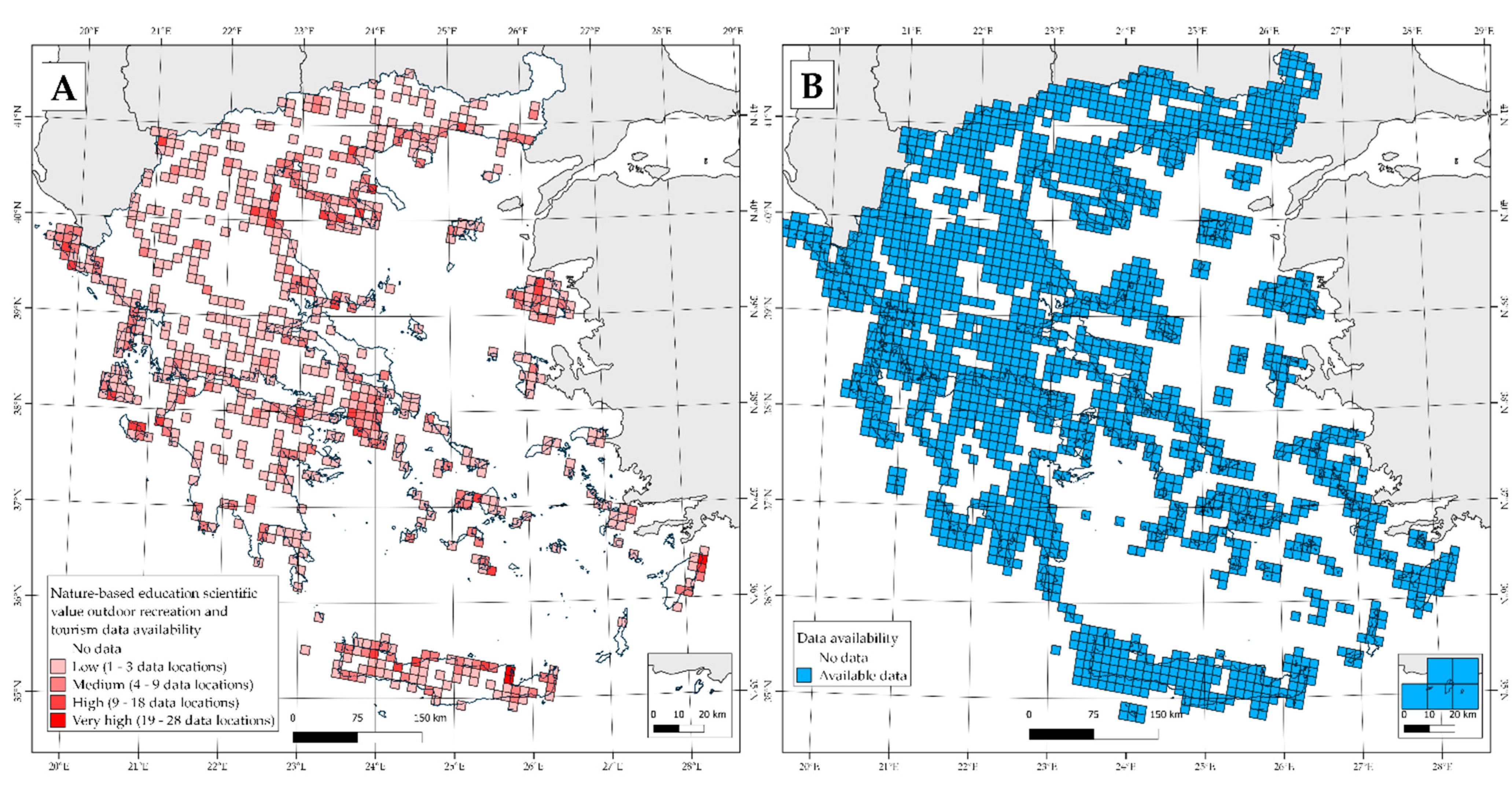
3.1. Mapping the Distribution and Intensity of Proxy Indicators
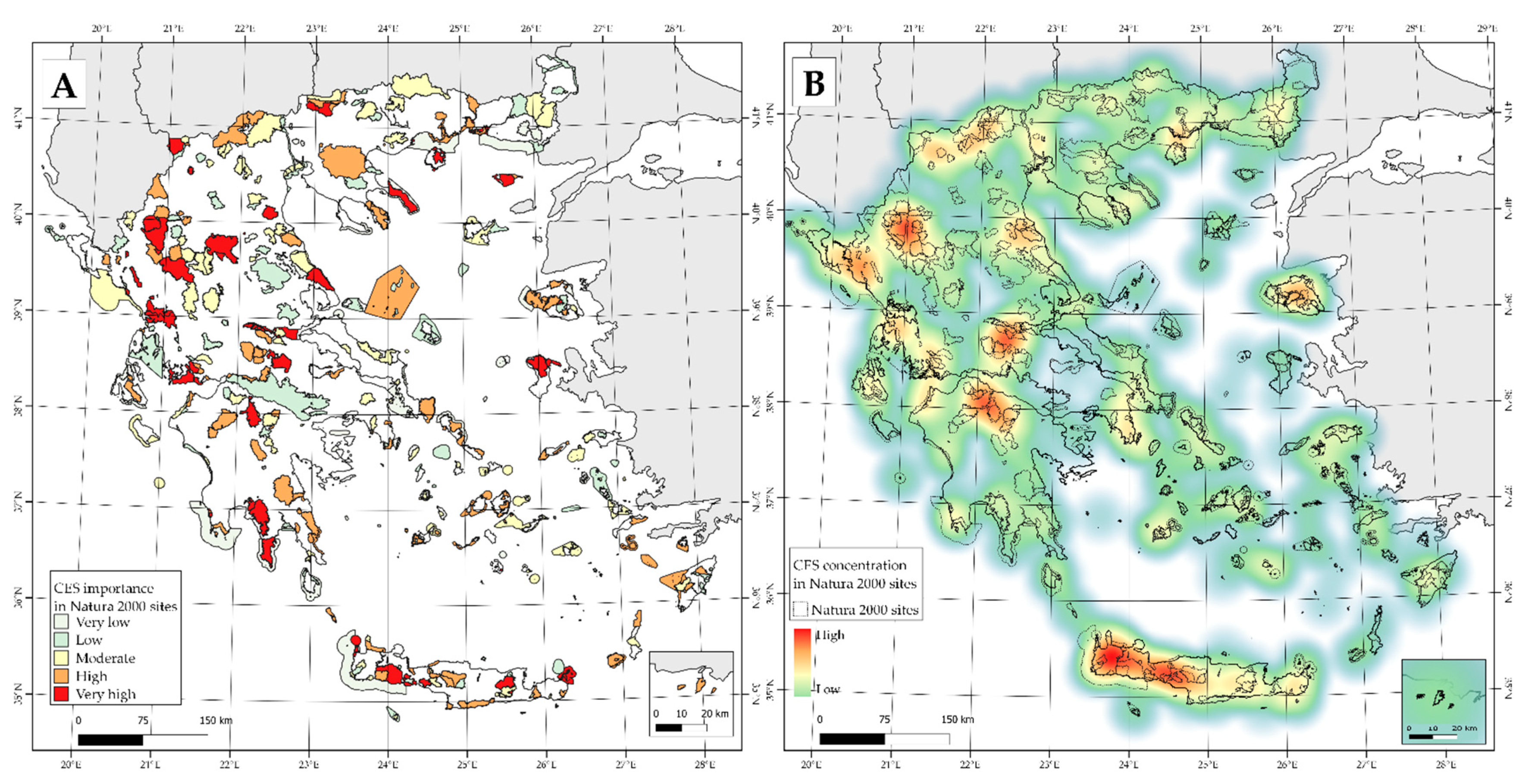
3.2. Cumulative Results at the State-Wide Natura 2000 Level
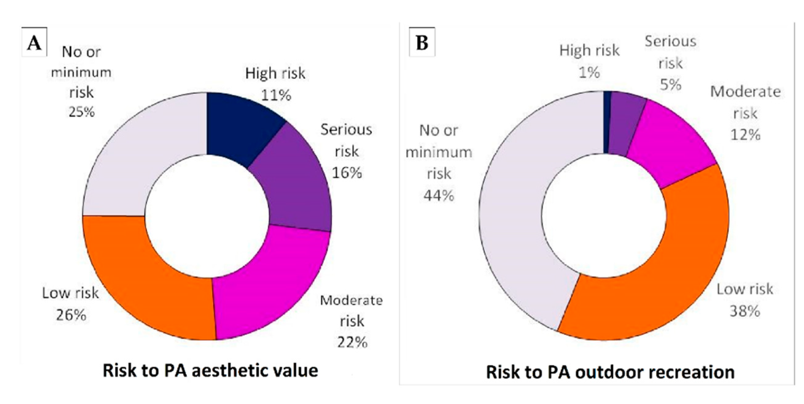
3.3. Wind Farm Conflict Risk
3.4. Uncertainties and Data Gaps
4. Discussion
4.1. Achievements and Context
- Available data were compiled to build an initial CES database per Natura site, providing an initial inventory. This work is exploratory since only easily accessible proxy indicators were selected as potential indicators; these are meant to be tested and expanded within future research investments. The current fit-for-purpose review follows the methodology and complements Greece’s National Mapping and Assessment of Ecosystem Services (MAES) indicators approach [43].
- By focusing on the state’s protected area network we can identify priority sites of outstanding CES values or sites “at risk”, i.e., an initial screening for prioritization “hot spots”. The resulting cartography provides results for a continuing discourse on CES and its utilization in protected area planning and management.
- We explore data and knowledge gaps with respect for the integration of wider conservation management needs (i.e., beyond the strict biodiversity needs) for the Natura 2000 network. This review also contributes by suggesting specific recommendations for future progress in developing knowledge baselines and inventory frameworks for protected areas in general; an important unmet need in Greece (see recommendations, below).
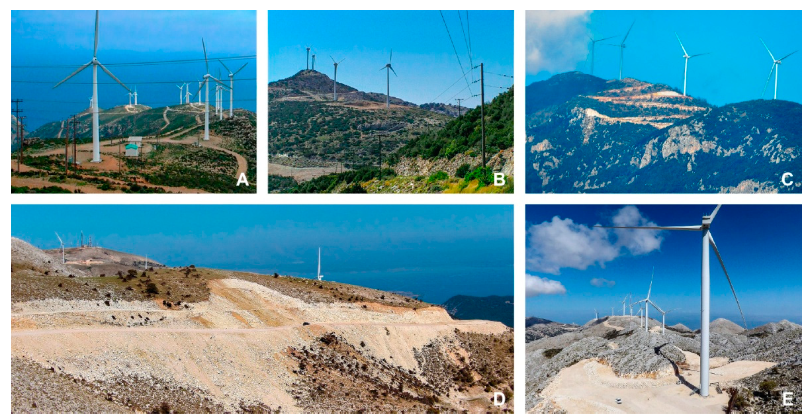
- The wind farm case study initiates a conflict risk mapping exercise. Utilizing CES assessment to identify management problems in protected areas is an important unmet need. Aesthetic and recreational values are important non-material values provided by ecosystems and landscapes in protected areas, yet their effective protection and enforcement is severely lacking in the Natura 2000 system in Greece. Our cursory screening shows that wind energy development, if continued as planned, will create wholesale changes and severe environmental and cultural degradation in many Natura sites.
4.2. Limitations of this Review
- Distance-based archival data or metadata previously collected by a single or few reviews may be subject to inherent biases [91], and in data-scarcity conditions bibliographical and online surveys cannot possibly be exhaustive.
- Natura sites have been differentially studied and biases exist based on their size (areal extent) and exact site-boundary delineations [62]. The larger and high-profile “famous” sites host much more and detailed available data, including cultural attributes and CES values. This situation is difficult to heal: the “smaller” and newer sites (including some peri-urban sites) are less studied and may lag behind in state-wide evaluations due to data gaps or data inventory biases [43].
- This work focuses mainly on mapping CES supply using proxy indicators, but CES demand is poorly defined here, though it is also important. Exploring social preferences would be a useful way forward in order to complement this inventory. Tradeoffs and synergies between bundles of services dependent on the ecosystems providing them and on appreciating demand for CES would be important in a revised review [92].
- Minimal social media data was compiled in this survey; only one citizens’ science portal on bird watching/birding hotspots (ebird) [93] was successfully utilized (i.e., accurately identifying locations with outstanding wildlife watching opportunities [94]). Especially since in protected areas local profit-generation depends on tourism, recreation and educational interest [95], involving more actors through social media and crowd-sourcing could enable plural valuation approaches; i.e., assessing multiple values attributed to nature by stakeholders [87,96,97,98].
- Marine CES are not investigated in our review for the reasons outlined by Kokkoris and colleagues in 2020 [43]. There are still inherent difficulties and outstanding data gaps in marine areas [99]; and marine protected areas are difficult to compare to terrestrial system conditions in a state-wide scale [100]. We expect specific reviews to develop in this important segment of protected area research soon [87].
- The distance-based risk mapping on wind farms is not a complete conflict risk analysis. In our opinion, this is a conservative and transparent prioritization screening exercise. This mechanistic representation cannot depict the many and various negative impacts of industrial wind farm developments on wild lands; e.g., where a small number of turbines are placed in inappropriate locations or where off-site wind turbines and their infrastructure may impact adjacent Natura sites. The prioritization exercise focuses on the most vulnerable frontline conflict Natura sites; and it is indicative of the distribution of potential cumulative impacts.
4.3. Recommendations
- A national inventory of CES and cultural attributes of all protected areas. Information on cultural values and CES within protected areas must be inventoried in a national registry (i.e., all cultural features, including hiking trails and paths, archeological sites and non-material site-based distinctions). Specific investigations should further explore the role of several Natura/protected area site factors, such as the site’s size, land cover types and changes, accessibility and other parameters in relation to CES attributes.
- Adaptive CES mixed methods research initiatives. The MAES methodology as well as mixed methods approaches (i.e., both quantitative and qualitative research) should be promoted [43]. Local priorities may dictate the need for indicators specific to single sites or a set of Natura sites (e.g., at the ecoregional or state regional level). It may be useful and important to identify a greater variety of CES types and indicators, and the precise structure of the services and who the beneficiaries are [8,110]. We urge flexibility when developing indicators and other evaluation schemes as has become apparent in recent so-called “post-normal science” applications [111]. A transdisciplinary and adaptive approach should be encouraged [27]. Flexibility in using indicators (including proxy indicators) must be upheld in order to drive exploratory and innovative research at this early stage of CES development in Greece.
- A landscape approach. More attention is needed to landscape-scale research and conservation, especially targeting both highly valued cultural landscapes [3,112] and wilderness (or wild land) areas [81,113]. This ties in with EU policy requirements for high nature value farming [114] and the many modern changes and challenges to European landscapes [79,115,116]. In Greece, particular attention to the conflicts created by industrial wind farm development should be immediately reviewed at the landscape scale. Our broad-scale survey suggests that potential degradation and threats to CES by wind farms in Natura sites may have been overlooked, ignored or even intentionally sidelined within the current renewable energy boom. At the scale of landscapes (sub-areas of the protected area sites) a critical assessment should be developed to explore and respond to the potential threats and risks of degradation to protected area integrity.
- A new emphasis on aesthetic values in protected areas. Aesthetic and scenic values, which are culturally important attributes, may have been overlooked while they have outstanding importance for human wellbeing and are vital components of landscape integrity [117,118]. Specific efforts to explore and document aesthetic values are required at both the protected area site and the wider landscape scale [119,120,121]. There are many applied approaches to assess and integrate landscape conservation in protected area management [122,123,124]. Aesthetics is a critical aspect of a CES review, but it is no doubt a “wicked problem” in conservation area management [125]. Compared to other CES attributes, aesthetic indicators may be highly subjective [8] and any attempt towards quantification requires accounting for the uncertainties induced from subjectivity [126]. Despite these difficulties, aesthetics is crucial in landscape planning and conservation, and its involvement in this CES review shows a need for less reductive and more holistic assessment approaches. More particularly for Greece, all available incentives to preserve the aesthetic quality of protected areas should be promoted; one step is to apply Law 1469/50 to inventory and delineate “Sites of Outstanding Natural Beauty” [53].
- A communication initiative. A strategy for public awareness to promote and effectively enforce protected area conservation initiatives is important. Part of the problem with ineffective conservation outcomes in protected areas is that knowledge about non-material benefits and values is poorly communicated and disseminated. Without investment in publicity and media initiatives for this, the broader socio-ecological issues, especially sensitive and complex ones such as CES, may fall in the back-seat of other conflicting and pressing issues [127,128]. An investment in CES research and its promotion provides a storehouse of the important knowledge needed for conservation-relevant communication, including multi-stakeholder collaboration and participation and education at all levels (including landscape literacy).
5. Conclusions
Author Contributions
Funding
Institutional Review Board Statement
Informed Consent Statement
Data Availability Statement
Acknowledgments
Conflicts of Interest
References
- Seardo, B.M. Biodiversity and landscape policies: Towards an integration? A European overview. In Nature Policies and Landscape Policies; Springer: Berlin/Heidelberg, Germany, 2015; pp. 261–268. [Google Scholar]
- Church, A.; Fish, R.; Haines-Young, R.; Mourato, S.; Tratalos, J.; Stapleton, L.; Willis, C.; Coates, P.; Gibbson, S.; Leyshon, C.; et al. UK National Ecosystem Assessment Follow-On: Work Package Report 5: Cultural Ecosystem Services and Indicators; UNEP-WCMC: Cambridge, UK, 2014. [Google Scholar]
- Tengberg, A.; Fredholm, S.; Eliasson, I.; Knez, I.; Saltzman, K.; Wetterberg, O. Cultural ecosystem services provided by landscapes: Assessment of heritage values and identity. Ecosyst. Serv. 2012, 2, 14–26. [Google Scholar] [CrossRef]
- Burkhard, B.; Kroll, F.; Müller, F.; Windhorst, W. Landscapes′ capacities to provide ecosystem services—A concept for land—cover based assessments. Landsc. Online 2009, 15, 1–22. [Google Scholar] [CrossRef]
- Jobstvogt, N.; Watson, V.; Kenter, J.O. Looking below the surface: The cultural ecosystem service values of UK marine protected areas (MPAs). Ecosyst. Serv. 2014, 10, 97–110. [Google Scholar] [CrossRef]
- Baulcomb, C.; Fletcher, R.; Lewis, A.; Akoglu, E.; Robinson, L.; von Almen, A.; Hussain, S.; Glenk, K. A pathway to identifying and valuing cultural ecosystem services: An application to marine food webs. Ecosyst. Serv. 2015, 11, 128–139. [Google Scholar] [CrossRef]
- Ainsworth, G.B.; Kenter, J.O.; O′Connor, S.; Daunt, F.; Young, J.C. A fulfilled human life: Eliciting sense of place and cultural identity in two UK marine environments through the Community Voice Method. Ecosyst. Serv. 2019, 39, 100992. [Google Scholar] [CrossRef]
- Bryce, R.; Irvine, K.N.; Church, A.; Fish, R.; Ranger, S.; Kenter, J.O. Subjective well-being indicators for large-scale assessment of cultural ecosystem services. Ecosyst. Serv. 2016, 21, 258–269. [Google Scholar] [CrossRef]
- Ament, J.M.; Moore, C.A.; Herbst, M.; Cumming, G.S. Cultural Ecosystem Services in Protected Areas: Understanding Bundles, Trade-Offs, and Synergies. Conserv. Lett. 2017, 10, 440–450. [Google Scholar] [CrossRef]
- Arbieu, U.; Grünewald, C.; Martín-López, B.; Schleuning, M.; Böhning-Gaese, K. Mismatches between supply and demand in wildlife tourism: Insights for assessing cultural ecosystem services. Ecol. Indic. 2017, 78, 282–291. [Google Scholar] [CrossRef]
- Satz, D.; Gould, R.K.; Chan, K.M.; Guerry, A.; Norton, B.; Satterfield, T.; Halpern, B.S.; Levine, J.; Woodside, U.; Hannahs, N.; et al. The challenges of incorporating cultural ecosystem services into environmental assessment. AMBIO 2013, 42, 675–684. [Google Scholar] [CrossRef]
- Albert, C.; Bonn, A.; Burkhard, B.; Daube, S.; Dietrich, K.; Engels, B.; Frommer, J.; Götzl, M.; Grêt-Regamey, A.; Job-Hoben, B.; et al. Towards a national set of ecosystem service indicators: Insights from Germany. Ecol. Indic. 2016, 61, 38–48. [Google Scholar] [CrossRef]
- Hummel, C.; Provenzale, A.; van der Meer, J.; Wijnhoven, S.; Nolte, A.; Poursanidis, D.; Janss, G.; Jurek, M.; Andresen, M.; Poulin, B.; et al. Ecosystem services in European protected areas: Ambiguity in the views of scientists and managers? PLoS ONE 2017, 12, e0187143. [Google Scholar] [CrossRef] [PubMed]
- Jaligot, R.; Hasler, S.; Chenal, J. National assessment of cultural ecosystem services: Participatory mapping in Switzerland. Ambio 2019, 48, 1219–1233. [Google Scholar] [CrossRef] [PubMed]
- Hernández-Morcillo, M.; Plieninger, T.; Bieling, C. An empirical review of cultural ecosystem service indicators. Ecol. Indic. 2013, 29, 434–444. [Google Scholar] [CrossRef]
- Pleasant, M.M.; Gray, S.A.; Lepczyk, C.; Fernandes, A.; Hunter, N.; Ford, D. Managing cultural ecosystem services. Ecosyst. Serv. 2014, 8, 141–147. [Google Scholar] [CrossRef]
- Müller, F.; Burkhard, B. The indicator side of ecosystem services. Ecosyst. Serv. 2012, 1, 26–30. [Google Scholar] [CrossRef]
- Thiagarajah, J.; Wong, S.K.M.; Richards, D.R.; Friess, D.A. Historical and contemporary cultural ecosystem service values in the rapidly urbanizing city state of Singapore. Ambio 2015, 44, 666–677. [Google Scholar] [CrossRef]
- Schirpke, U.; Scolozzi, R.; De Marco, C.; Tappeiner, U. Mapping beneficiaries of ecosystem services flows from Natura 2000 sites. Ecosyst. Serv. 2014, 9, 170–179. [Google Scholar] [CrossRef]
- Nahuelhual, L.; Carmona, A.; Lozada, P.; Jaramillo, A.; Aguayo, M. Mapping recreation and ecotourism as a cultural ecosystem service: An application at the local level in Southern Chile. Appl. Geogr. 2013, 40, 71–82. [Google Scholar] [CrossRef]
- Pastur, G.M.; Peri, P.L.; Lencinas, M.V.; García-Llorente, M.; Martín-López, B. Spatial patterns of cultural ecosystem services provision in Southern Patagonia. Landsc. Ecol. 2016, 31, 383–399. [Google Scholar] [CrossRef]
- Mauerhofer, V.; Ichinose, T.; Blackwell, B.D.; Willig, M.R.; Flint, C.G.; Krause, M.; Penker, M. Underuse of social-ecological systems: A research agenda for addressing challenges to biocultural diversity. Land Use Policy 2018, 72, 57–64. [Google Scholar] [CrossRef]
- Friess, D.A.; Yando, E.S.; Wong, L.-W.; Bhatia, N. Indicators of scientific value: An under-recognised ecosystem service of coastal and marine habitats. Ecol. Indic. 2020, 113, 106255. [Google Scholar] [CrossRef]
- Kirchhoff, T. Abandoning the concept of cultural ecosystem services, or against natural–scientific imperialism. BioScience 2019, 69, 220–227. [Google Scholar] [CrossRef]
- Schaubroeck, T. The concept of cultural ecosystem services should not be abandoned. BioScience 2019, 69, 585. [Google Scholar] [CrossRef]
- Spyra, M.; Kleemann, J.; Cetin, N.I.; Navarrete, C.J.V.; Albert, C.; Palacios-Agundez, I.; Ametzaga-Arregi, I.; La Rosa, D.; Rozas-Vásquez, D.; Esmail, B.A.; et al. The ecosystem services concept: A new Esperanto to facilitate participatory planning processes? Landsc. Ecol. 2019, 34, 1715–1735. [Google Scholar] [CrossRef]
- Paracchini, M.L.; Zulian, G.; Kopperoinen, L.; Maes, J.; Schägner, J.P.; Termansen, M.; Zandersen, M.; Perez-Soba, M.; Scholefield, P.A.; Bidoglio, G. Mapping cultural ecosystem services: A framework to assess the potential for outdoor recreation across the EU. Ecol. Indic. 2014, 45, 371–385. [Google Scholar] [CrossRef]
- Vogiatzakis, I.N.; Zotos, S.; Litskas, V.D.; Manolaki, P.; Sarris, D.; Stavrinides, M. Towards implementing Mapping and Assessment of Ecosystems and their Services in Cyprus: A first set of indicators for ecosystem management. One Ecosyst. 2020, 5, e47715. [Google Scholar] [CrossRef]
- Mitchell, M.G.E.; Schuster, R.; Jacob, A.L.; Hanna, D.E.L.; Dallaire, C.O.; Raudsepp-Hearne, C.; Bennett, E.; Lehner, B.; Chan, K.M.A. Identifying key ecosystem service providing areas to inform national-scale conservation planning. Environ. Res. Lett. 2020, in press. [Google Scholar] [CrossRef]
- Arbieu, U.; Grünewald, C.; Martín-López, B.; Schleuning, M.; Böhning-Gaese, K. Large mammal diversity matters for wildlife tourism in Southern African Protected Areas: Insights for management. Ecosyst. Serv. 2018, 31, 481–490. [Google Scholar] [CrossRef]
- Watson, J.E.; Dudley, N.; Segan, D.B.; Hockings, M. The performance and potential of protected areas. Nature 2014, 515, 67–73. [Google Scholar] [CrossRef]
- Blicharska, M.; Smithers, R.J.; Hedblom, M.; Hedenås, H.; Mikusiński, G.; Pedersen, E.; Sandström, P.; Svensson, J. Shades of grey challenge practical application of the cultural ecosystem services concept. Ecosyst. Serv. 2017, 23, 55–70. [Google Scholar] [CrossRef]
- Bennett, G. Integrating Biodiversity Conservation and Sustainable Use: Lessons Learned from Ecological Networks; IUCN: Gland, Switzerland, 2004. [Google Scholar]
- Jones, N.; McGinlay, J.; Dimitrakopoulos, P.G. Improving social impact assessment of protected areas: A review of the literature and directions for future research. Environ. Impact Assess. Rev. 2017, 64, 1–7. [Google Scholar] [CrossRef]
- Ferranti, F.; Turnhout, E.; Beunen, R.; Behagel, J.H. Shifting nature conservation approaches in Natura 2000 and the implications for the roles of stakeholders. J. Environ. Plan. Manag. 2014, 57, 1642–1657. [Google Scholar] [CrossRef]
- Kati, V.; Hovardas, T.; Dieterich, M.; Ibisch, P.L.; Mihok, B.; Selva, N. The challenge of implementing the European network of protected areas Natura 2000. Conserv. Biol. 2015, 29, 260–270. [Google Scholar] [CrossRef] [PubMed]
- Balzan, M.V.; Pinheiro, A.M.; Mascarenhas, A.; Morán-Ordóñez, A.; Ruiz-Frau, A.; Carvalho-Santos, C.; Vogiatzakis, I.N.; Arends, J.; Santana-Garcon, J.; Roces-Díaz, J.V.; et al. Improving ecosystem assessments in Mediterranean social-ecological systems: A DPSIR analysis. Ecosyst. People 2019, 15, 136–155. [Google Scholar] [CrossRef]
- Blondel, J.; Aronson, J.; Bodiou, J.-Y.; Boeuf, G. The Mediterranean Region: Biological Diversity in Space and Time; Oxford University Press: Oxford, UK, 2010. [Google Scholar]
- Catsadorakis, G. The conservation of natural and cultural heritage in Europe and the Mediterranean: A Gordian knot? Int. J. Herit. Stud. 2007, 13, 308–320. [Google Scholar] [CrossRef]
- Kizos, T.; Koulouri, M.; Vakoufaris, H.; Psarrou, M. Preserving characteristics of the agricultural landscape through agri-environmental policies: The case of cultivation terraces in Greece. Landsc. Res. 2010, 35, 577–593. [Google Scholar] [CrossRef]
- Papageorgiou, K.; Vogiatzakis, I.N. Nature protection in Greece: An appraisal of the factors shaping integrative conservation and policy effectiveness. Environ. Sci. Policy 2006, 9, 476–486. [Google Scholar] [CrossRef]
- Zogaris, S.; Skoulikidis, N.; Dimitriou, E. River and wetland restoration in Greece: Lessons from biodiversity conservation initiatives. In The Rivers of Greece; Springer: Berlin/Heidelberg, Germany, 2017; pp. 403–431. [Google Scholar]
- Kokkoris, I.P.; Mallinis, G.; Bekri, E.S.; Vlami, V.; Zogaris, S.; Chrysafis, I.; Mitsopoulos, I.; Dimopoulos, P. National Set of MAES Indicators in Greece: Ecosystem Services and Management Implications. Forests 2020, 11, 595. [Google Scholar] [CrossRef]
- Dimopoulos, P.; Drakou, E.; Kokkoris, I.P.; Katsanevakis, S.; Kallimanis, A.; Tsiafouli, M.; Bormpoudakis, D.; Kormas, K.; Arends, J. The need for the implementation of an Ecosystem Services assessment in Greece: Drafting the national agenda. One Ecosyst. 2017, 2, e13714. [Google Scholar] [CrossRef]
- Apostolopoulou, E.; Adams, W.M. Neoliberal capitalism and conservation in the post-crisis era: The dialectics of “green” and “un-green” grabbing in Greece and the UK. Antipode 2015, 47, 15–35. [Google Scholar] [CrossRef]
- Tratsa, M. What is left on the environmental map after “the eraser of the Ministry of Environment and Energy”. To Vima 2020, 143, 60. [Google Scholar]
- Lekakis, J.N.; Kousis, M. Economic crisis, Troika and the environment in Greece. South Eur. Soc. Polit. 2013, 18, 305–331. [Google Scholar] [CrossRef]
- Paliogiannis, C.; Cliquet, A.; Koedam, N. The impact of the economic crisis on the implementation of the EU Nature Directives in Greece: An expert-based view. J. Nat. Conserv. 2019, 48, 36–46. [Google Scholar] [CrossRef]
- Aperghis, G.; Gaethlich, M. The natural environment of Greece: An invaluable asset being destroyed. J. Southeast Eur. Black Sea Stud. 2006, 6, 377–390. [Google Scholar] [CrossRef]
- Papayannis, T. Action for Culture in Mediterranean Wetlands; Mediterranean Institute for Nature and Arthropods: Athens, Greece, 2008. [Google Scholar]
- Katapidi, I. Does Greek conservatIon policy effectively protect the cultural landscapes? A critical examination of policy’s efficiency in traditional Greek settlements. Eur. Spat. Res. Policy 2014, 21, 97–113. [Google Scholar] [CrossRef][Green Version]
- Tsilimigkas, G.; Derdemezi, E.-T. Spatial Planning and the Traditional Settlements Management: Evidence from Visibility Analysis of Traditional Settlements in Cyclades, Greece. Plan. Pract. Res. 2020, 35, 86–106. [Google Scholar] [CrossRef]
- Beriatos, E. The Stymfalia Conviction and gaps in landscape policy in Greece. Aeihoros 2014, 19, 140–157. [Google Scholar]
- Balvanera, P.; Jacobs, S.; Nagendra, H.; O’Farrell, P.; Bridgewater, P.; Crouzat, E.; Dendoncker, N.; Goodwin, S.; Gustafsson, K.M.; Kadykalo, A.N.; et al. The science-policy interface on ecosystems and people: Challenges and opportunities. Ecosyst. People 2020, 16, 345–353. [Google Scholar] [CrossRef]
- Santarém, F.; Saarinen, J.; Brito, J.C. Mapping and analysing cultural ecosystem services in conflict areas. Ecol. Indic. 2020, 110, 105943. [Google Scholar] [CrossRef]
- Carlucci, M.; Vinci, S.; Lamonica, G.R.; Salvati, L. Socio-spatial Disparities and the Crisis: Swimming Pools as a Proxy of Class Segregation in Athens. Soc. Indic. Res. 2020, 1–25. [Google Scholar] [CrossRef]
- Priority Action Framework. Setting Priorities for Nature Conservation Within the Natura 2000 Network in Greece (Council Directive 92/43/EC, Directive 2009/147/EC); European Commision: Brussels, Belgium, 2014. [Google Scholar]
- Christopoulou, I. Priority in Nature: Evaluating the Implementation of the National Biodiversity Strategy; The Green Tank: Athens, Greece, 2020. (In Greek) [Google Scholar]
- Kokkoris, I.P.; Drakou, E.G.; Maes, J.; Dimopoulos, P. Ecosystem services supply in protected mountains of Greece: Setting the baseline for conservation management. Int. J. Biodivers. Sci. Ecosyst. Serv. Manag. 2018, 14, 45–59. [Google Scholar] [CrossRef]
- Dimopoulos, P.; Bergmeier, E.; Theodoropoulos, K.; Fischer, P.; Tsiafouli, M. Monitoring Guide for Habitat Types and Plant Species in the Natura 2000 Sites of Greece with Management Institutions; University of Ioannina and Hellenic Ministry of the Environment, Physical Planning & Public Works: Agrinio, Greece, 2005; p. 170. (In Greek) [Google Scholar]
- EEA. EEA Reference Grid. Available online: https://www.eea.europa.eu/data-and-maps/data/eea-reference-grids-2 (accessed on 12 April 2020).
- Vlami, V.; Kokkoris, I.P.; Zogaris, S.; Cartalis, C.; Kehayias, G.; Dimopoulos, P. Cultural landscapes and attributes of “culturalness” in protected areas: An exploratory assessment in Greece. Sci. Total Environ. 2017, 595, 229–243. [Google Scholar] [CrossRef] [PubMed]
- Maes, J.; Teller, A.; Erhard, M.; Liquete, C.; Braat, L.; Berry, P.; Egoh, B.; Puydarrieux, P.; Fiorina, C.; Santos, F. Mapping and Assessment of Ecosystems and their Services. Analytical Framework for Ecosystem Assessments under Action 5 of the EU Biodiversity Strategy to 2020. 2nd Report-Final; Publication Office of the European Union: Luxemburg, 2013. [Google Scholar]
- Maes, J.; Teller, A.; Erhard, M.; Condé, S.; Vallecillo, S.; Barredo, J.I.; Paracchini, M.L.; Abdul Malak, D.; Trombetti, M.; Vigiak, O.; et al. Mapping and Assessment of Ecosystems and their Services: An EU Ecosystem Assessment; Publications Office of the European Union: Luxemburg, 2020; p. 446. [Google Scholar]
- Hellenic Ministry of the Environment, Energy and Climate Change. National Biodiversity Strategy and Action Plan; Ministry of the Environment, Energy and Climate Change: Athens, Greece, 2014.
- Haines-Young, R.; Potschin-Young, M.B. Common International Classification of Ecosystem Services (CICES) V5. 1 and Guidance on the Application of the Revised Structure; Fabis Consulting Ltd.: Nottingham, UK, 2018; Volume 27. [Google Scholar]
- Van Oudenhoven, A.P.; Schröter, M.; Drakou, E.G.; Geijzendorffer, I.R.; Jacobs, S.; van Bodegom, P.M.; Chazee, L.; Czúcz, B.; Grunewald, K.; Lillebø, A.I. Key criteria for developing ecosystem service indicators to inform decision making. Ecol. Indic. 2018, 95, 417–426. [Google Scholar] [CrossRef]
- QGIS Development Team. QGIS Geographic Information System. Open Source Geospatial Foundation Project 2016. Available online: http://qgis.osgeo.org (accessed on 31 March 2020).
- Czyż, T. Methodological problems in the design of indicators in social sciences with the focus on socio-economic geography. Studia Reg. 2017, 50, 49–61. [Google Scholar]
- RAE. Wind Turbines Point Vector Shapefile 2020 by Regulatory Authority for Energy (RAE). Available online: http://www.rae.gr/geo/ (accessed on 20 February 2020).
- ESRI. FAQ: What Is The Jenkins Optimization Method? Available online: https://support.esri.com/en/technical-article/000006743 (accessed on 23 March 2020).
- Jenks, G.F. The data model concept in statistical mapping. Int. Yearb. Cartogr. 1967, 7, 186–190. [Google Scholar]
- McMaster, R. In Memoriam: George, F. Jenks (1916–1996). Cartogr. Geogr. Inf. Sci. 1997, 24, 56–59. [Google Scholar] [CrossRef]
- Andreopoulos, D.; Damigos, D.; Comiti, F.; Fischer, C. Estimating the non-market benefits of climate change adaptation of river ecosystem services: A choice experiment application in the Aoos basin, Greece. Environ. Sci. Policy 2015, 45, 92–103. [Google Scholar] [CrossRef]
- Nikolaidou, C.; Votsi, N.-E.; Sgardelis, S.; Halley, J.; Pantis, J.; Tsiafouli, M. Ecosystem Service capacity is higher in areas of multiple designation types. One Ecosyst. 2017, 2, e13718. [Google Scholar] [CrossRef]
- Ariza-Montobbio, P.; Farrell, K.N. Wind farm siting and protected areas in catalonia: Planning alternatives or reproducing ′one-dimensional thinking′? Sustainability 2012, 4, 3180–3205. [Google Scholar] [CrossRef]
- Vlami, V.; Danek, J.; Zogaris, S.; Gallou, E.; Kokkoris, I.P.; Kehayias, G.; Dimopoulos, P. Residents’ Views on Landscape and Ecosystem Services during a Wind Farm Proposal in an Island Protected Area. Sustainability 2020, 12, 2442. [Google Scholar] [CrossRef]
- Dimalexis, A.; Kastritis, T.; Manolopoulos, A.; Korbeti, M.; Fric, J.; Saravia Mullin, V.; Xirouchakis, S.; Bousbouras, D. Identification and Mapping of Sensitive Bird Areas to Wind Farm Development in Greece; Hellenic Ornithological Society: Athens, Greece, 2010; p. 126. [Google Scholar]
- Marsden, S. Protecting wild land from wind farms in a post-EU Scotland. Int. Environ. Agreements 2018, 18, 295–314. [Google Scholar] [CrossRef]
- Rehbein, J.A.; Watson, J.E.; Lane, J.L.; Sonter, L.J.; Venter, O.; Atkinson, S.C.; Allan, J.R. Renewable energy development threatens many globally important biodiversity areas. Glob. Change Biol. 2020, 26, 3040–3051. [Google Scholar] [CrossRef] [PubMed]
- Allan, J.R.; Possingham, H.P.; Venter, O.; Biggs, D.; Watson, J.E. The Extraordinary Value of Wilderness Areas in the Anthropocene. In Encyclopedia of the World’s Biomes; Elsevier: Amsterdam, The Netherlands, 2020. [Google Scholar]
- Kokkoris, I.P.; Dimopoulos, P.; Xystrakis, F.; Tsiripidis, I. National scale ecosystem condition assessment with emphasis on forest types in Greece. One Ecosyst. 2018, 3, e25434. [Google Scholar] [CrossRef]
- Heink, U.; Kowarik, I. What are indicators? On the definition of indicators in ecology and environmental planning. Ecol. Indic. 2010, 10, 584–593. [Google Scholar] [CrossRef]
- Hølleland, H.; Skrede, J.; Holmgaard, S.B. Cultural heritage and ecosystem services: A literature review. Conserv. Manag. Archaeol. Sites 2017, 19, 210–237. [Google Scholar] [CrossRef]
- Mertzanis, Α.; Syleouni, S.; Mertzanis, K.; Zogaris, S. Ecotourism promotion in a greek national park: The development and management of farmakides trail on mt oiti. Ecol. Saf. 2016, 10, 204–228. [Google Scholar]
- Kokkoris, I.P.; Bekri, E.S.; Skuras, D.; Vlami, V.; Zogaris, S.; Maroulis, G.; Dimopoulos, D.; Dimopoulos, P. Integrating MAES implementation into protected area management under climate change: A fine-scale application in Greece. Sci. Total Environ. 2019, 695, 133530. [Google Scholar] [CrossRef]
- Ruiz-Frau, A.; Ospina-Alvarez, A.; Villasante, S.; Pita, P.; Maya-Jariego, I.; de Juan, S. Using graph theory and social media data to assess cultural ecosystem services in coastal areas: Method development and application. Ecosyst. Serv. 2020, 45, 101176. [Google Scholar] [CrossRef]
- Grêt-Regamey, A.; Sirén, E.; Brunner, S.H.; Weibel, B. Review of decision support tools to operationalize the ecosystem services concept. Ecosyst. Serv. 2017, 26, 306–315. [Google Scholar] [CrossRef]
- Stevance, A.-S.; Bridgewater, P.; Louafi, S.; King, N.; Beard, T.D., Jr.; Van Jaarsveld, A.S.; Ofir, Z.; Kohsaka, R.; Jenderedijan, K.; Rosales Benites, M.; et al. The 2019 review of IPBES and future priorities: Reaching beyond assessment to enhance policy impact. Ecosyst. People 2020, 16, 70–77. [Google Scholar] [CrossRef]
- Seidl, A. Cultural ecosystem services and economic development: World Heritage and early efforts at tourism in Albania. Ecosyst. Serv. 2014, 10, 164–171. [Google Scholar] [CrossRef]
- Marshall, C.; Rossman, G.B. Designing Qualitative Research; Sage Publications: Thousand Oaks, CA, USA, 2014. [Google Scholar]
- Martín-López, B.; Iniesta-Arandia, I.; García-Llorente, M.; Palomo, I.; Casado-Arzuaga, I.; Del Amo, D.G.; Gómez-Baggethun, E.; Oteros-Rozas, E.; Palacios-Agundez, I.; Willaarts, B.; et al. Uncovering ecosystem service bundles through social preferences. PLoS ONE 2012, 7, e38970. [Google Scholar] [CrossRef] [PubMed]
- Sullivan, B.L.; Aycrigg, J.L.; Barry, J.H.; Bonney, R.E.; Bruns, N.; Cooper, C.B.; Damoulas, T.; Dhondt, A.A.; Dietterich, T.; Farnsworth, A.; et al. The eBird enterprise: An integrated approach to development and application of citizen science. Biol. Conserv. 2014, 169, 31–40. [Google Scholar] [CrossRef]
- Portolou, D.; Vlachos, C.; Kastritis, T.; Dimalexis, T. The Important Bird Areas of Greece: Priority Areas for Biodiversity Conservation; Hellenic Ornithological Society: Athens, Greece, 2009. [Google Scholar]
- Tenerelli, P.; Demšar, U.; Luque, S. Crowdsourcing indicators for cultural ecosystem services: A geographically weighted approach for mountain landscapes. Ecol. Indic. 2016, 64, 237–248. [Google Scholar] [CrossRef]
- Oteros-Rozas, E.; Martín-López, B.; Fagerholm, N.; Bieling, C.; Plieninger, T. Using social media photos to explore the relation between cultural ecosystem services and landscape features across five European sites. Ecol. Indic. 2018, 94, 74–86. [Google Scholar] [CrossRef]
- Kilonzi, F.; Ota, T. Influence of cultural contexts on the appreciation of different cultural ecosystem services based on social network analysis. One Ecosyst. 2019, 4, e33368. [Google Scholar] [CrossRef]
- Jacobs, S.; Zafra-Calvo, N.; Gonzalez-Jimenez, D.; Guibrunet, L.; Benessaiah, K.; Berghöfer, A.; Chaves-Chaparro, J.; Díaz, S.; Gomez-Baggethun, E.; Lele, S.; et al. Use your power for good: Plural valuation of nature–the Oaxaca statement. Glob. Sustain. 2020, 3. [Google Scholar] [CrossRef]
- Salomidi, M.; Katsanevakis, S.; Borja, A.; Braeckman, U.; Damalas, D.; Galparsoro, I.; Mifsud, R.; Mirto, S.; Pascual, M.; Pipitone, C.; et al. Assessment of goods and services, vulnerability, and conservation status of European seabed biotopes: A stepping stone towards ecosystem-based marine spatial management. Mediterr. Mar. Sci. 2012, 13, 49–88. [Google Scholar] [CrossRef]
- Fletcher, R.; Baulcomb, C.; Hall, C.; Hussain, S. Revealing marine cultural ecosystem services in the Black Sea. Mar. Policy 2014, 50, 151–161. [Google Scholar] [CrossRef]
- Brown, C.J.; Bode, M.; Venter, O.; Barnes, M.D.; McGowan, J.; Runge, C.A.; Watson, J.E.; Possingham, H.P. Effective conservation requires clear objectives and prioritizing actions, not places or species. Proc. Natl. Acad. Sci. USA 2015, 112, 4342. [Google Scholar] [CrossRef]
- Game, E.T.; Kareiva, P.; Possingham, H.P. Six common mistakes in conservation priority setting. Conserv. Biol. 2013, 27, 480–485. [Google Scholar] [CrossRef] [PubMed]
- Mikkonen, N.; Moilanen, A. Identification of top priority areas and management landscapes from a national Natura 2000 network. Environ. Sci. Policy 2013, 27, 11–20. [Google Scholar] [CrossRef]
- Collen, B. Conservation prioritization in the context of uncertainty. Anim. Conserv. 2015, 18, 315–317. [Google Scholar] [CrossRef]
- English, A.J.; Lee, E. Managing the Intangible; The George Wright Forum, JSTOR: New York, NY, USA, 2004; pp. 23–33. [Google Scholar]
- Haslett, J.R.; Berry, P.M.; Bela, G.; Jongman, R.H.; Pataki, G.; Samways, M.J.; Zobel, M. Changing conservation strategies in Europe: A framework integrating ecosystem services and dynamics. Biodivers. Conserv. 2010, 19, 2963–2977. [Google Scholar] [CrossRef]
- Hermoso, V.; Clavero, M.; Villero, D.; Brotons, L. EU’s conservation efforts need more strategic investment to meet continental commitments. Conserv. Lett. 2017, 10, 231–237. [Google Scholar] [CrossRef]
- Hermoso, V.; Morán-Ordóñez, A.; Canessa, S.; Brotons, L. Dynamic strategy for EU conservation. Science 2019, 363, 592–593. [Google Scholar]
- Tsianou, M.A.; Mazaris, A.D.; Kallimanis, A.S.; Deligioridi, P.S.K.; Apostolopoulou, E.; Pantis, J.D. Identifying the criteria underlying the political decision for the prioritization of the Greek Natura 2000 conservation network. Biol. Conserv. 2013, 166, 103–110. [Google Scholar] [CrossRef]
- Fish, R.; Church, A.; Winter, M. Conceptualising cultural ecosystem services: A novel framework for research and critical engagement. Ecosyst. Serv. 2016, 21, 208–217. [Google Scholar] [CrossRef]
- Ainscough, J.; Wilson, M.; Kenter, J.O. Ecosystem services as a post-normal field of science. Ecosyst. Serv. 2018, 31, 93–101. [Google Scholar] [CrossRef]
- Phillips, A.; Union, W.C. Management Guidelines for IUCN Category V Protected Areas: Protected Landscapes/Seascapes; IUCN—The World Conservation Union: Gland, Switzerland, 2002; Volume 9. [Google Scholar]
- Fisher, M.; Carver, S.; Kun, Z.; McMorran, R.; Arrell, K.; Mitchell, G. Review of Status and Conservation of Wild Land in Europe. Report; The Wildland Research Institute, University of Leeds: Leeds, UK, 2010; Volume 148, p. 131. [Google Scholar]
- Brunbjerg, A.K.; Bladt, J.; Brink, M.; Fredshavn, J.; Mikkelsen, P.; Moeslund, J.E.; Nygaard, B.; Skov, F.; Ejrnæs, R. Development and implementation of a high nature value (HNV) farming indicator for Denmark. Ecol. Indic. 2016, 61, 274–281. [Google Scholar] [CrossRef]
- García-Martín, M.; Quintas-Soriano, C.; Torralba, M.; Wolpert, F.; Plieninger, T. Landscape Change in Europe. In Sustainable Land Management in a European Context; Springer: Cham, Switzerland, 2020; pp. 17–37. [Google Scholar]
- Marine, N.; Arnaiz-Schmitz, C.; Herrero-Jáuregui, C.; de la O Cabrera, M.R.; Escudero, D.; Schmitz, M.F. Protected Landscapes in Spain: Reasons for Protection and Sustainability of Conservation Management. Sustainability 2020, 12, 6913. [Google Scholar] [CrossRef]
- Gobster, P.H.; Nassauer, J.I.; Daniel, T.C.; Fry, G. The shared landscape: What does aesthetics have to do with ecology? Landsc. Ecol. 2007, 22, 959–972. [Google Scholar] [CrossRef]
- Wu, J. Landscape of culture and culture of landscape: Does landscape ecology need culture? Lands. Ecol. 2010, 25, 1147–1150. [Google Scholar] [CrossRef]
- Daniel, T.C. Measuring Landscape Esthetics: The Scenic Beauty Estimation Method; Department of Agriculture, Forest Service, Rocky Mountain Forest and Range: Fort Collins, CO, USA, 1976; Volume 167.
- Bieling, C.; Plieninger, T. Recording manifestations of cultural ecosystem services in the landscape. Landsc. Res. 2013, 38, 649–667. [Google Scholar] [CrossRef]
- Vlami, V.; Zogaris, S.; Djuma, H.; Kokkoris, I.P.; Kehayias, G.; Dimopoulos, P. A Field Method for Landscape Conservation Surveying: The Landscape Assessment Protocol (LAP). Sustainability 2019, 11, 2019. [Google Scholar] [CrossRef]
- Syrbe, R.-U.; Walz, U. Spatial indicators for the assessment of ecosystem services: Providing, benefiting and connecting areas and landscape metrics. Ecol. Indic. 2012, 21, 80–88. [Google Scholar] [CrossRef]
- Palomo, I.; Martín-López, B.; Potschin, M.; Haines-Young, R.; Montes, C. National Parks, buffer zones and surrounding lands: Mapping ecosystem service flows. Ecosyst. Serv. 2013, 4, 104–116. [Google Scholar] [CrossRef]
- Ungaro, F.; Häfner, K.; Zasada, I.; Piorr, A. Mapping cultural ecosystem services: Connecting visual landscape quality to cost estimations for enhanced services provision. Land Use Policy 2016, 54, 399–412. [Google Scholar] [CrossRef]
- Dronova, I. Landscape beauty: A wicked problem in sustainable ecosystem management? Sci. Total Environ. 2019, 688, 584–591. [Google Scholar] [CrossRef]
- Manta, E.; Ioannidis, R.; Sargentis, G.-F.; Efstratiadis, A. Aesthetic Evaluation of Wind Turbines in Stochastic Setting: Case Study of Tinos Island, Greece. In Proceedings of the EGU General Assembly Conference Abstracts, Vienna, Austria, 4–8 May 2020; p. 5484. [Google Scholar]
- Piperopoulos, G.P.; Tsantopoulos, G.E. The characteristics of environmental organisations in Greece in relation to employment of a public relations officer. Environ. Polit. 2006, 15, 454–461. [Google Scholar] [CrossRef]
- Aruguete, M.S.; Gillen, M.M.; McCutcheon, L.E.; Bernstein, M.J. Disconnection from nature and interest in mass media. Appl. Environ. Educ. Commun. 2020, 19, 363–374. [Google Scholar] [CrossRef]


| Category | Indicator | Description | Indicatum (Property Indicated by Indicators) and Data Source for This Survey | CISES (V5.1) Code and Category Equivalent | Certainty Score (Expert Judgment; 1–5) and Comments |
|---|---|---|---|---|---|
| 1. Culture and Heritage | 1. Protected Area Archeological Value | Archeological value based on number and significance of sites within the protected area [62] | Sites of salient cultural heritage and relic monuments from pre-history to 1830. Source: Pleiades database/Metadata | 3.1.2.3 (heritage, cultural) | 5—ready for use. Salient inventory of designated archaeological sites. However, many archeological sites are not well delineated with exact areal boundaries |
| 2. Protected Area Traditional Settlement | Value of protected area based on designated traditional settlements within protected area boundaries [62] | Preserved structure of settlement; outstanding interest for heritage value. Source: Metadata | 3.1.2.3 (heritage, cultural) | 5—ready for use. Designated sites have been identified; however the designation registry is not considered complete | |
| 3. Protected Area Traditional Farming | Importance of protected area based on area given to traditional farming practices in protected area [62] | Small-scale farming methods maintained; potentially including high nature value farming areas. Source: Metadata | 3.1.2.3 (heritage, cultural) | 3—medium. Uncertainty exists in defining areas with objective criteria; no baselines available doing this rapidly in a feasible manner | |
| 4. Protected Area Working Village | Presence of villages within the protected area | Small-scale or other farming/grazing maintained present. Source: Metadata | 3.1.2.3 (heritage, cultural) | 4—high. Relation to CES values not always legitimate; some villages relate to living rural settlements that provide high nature value farming | |
| 5. Protected Area Mythical Places | Mention of the site in classical mythology | Historic non-material place-values. Source: Metadata | 3.2.1.1 (symbolic) | 3—medium. Reference currently based on a single study (Olalla 2002 in Metadata) | |
| 6. Protected Area High Culturalness | Over 50% protected Area covered by cultural land cover and/or culturally modified habitat types [62] | Areas of outstanding biodiversity values dominated by human-altered habitat types (i.e., designated biodiversity rich cultural landscapes). Source: Metadata | 3.1.2.3 (heritage, cultural) | 3—medium. Habitat type delineations differ markedly from Corine land cover delineations Difficult to be certain about baselines; difficult to map with precision and consistency | |
| 2. Nature-Based Education and Scientific Value | 7. Environmental Education Centers | Government-run education centers for schools and continuing education | Government-enacted schooling-oriented facilities; refers to nodes of environmental education activities pertaining to natural areas in the vicinity. Source: Online Survey (This study) | 3.1.2.2 (educational) | 3—medium. Education centers often created by political decisions and relative to educational or other socio-economic interests. Inconsistent in terms of how these centers and associated activities relate with CES attributes of site |
| 8. Environmental Information Centers | All types of “nature center” facilities, such as information centers in protected areas, special and specialized exhibits and events that focus on nature awareness, conservation education and scientific dissemination of research and natural history promotion in general | Usually direct connection to natural areas in the vicinity. In order for state authorities to build such an information center, specific interests and values exist in the vicinity. Source: Online Survey (This study) | 3.1.2.1 (scientific), 3.1.2.2 (educational) | 4—high. Mostly related to protected areas and an important infrastructure for tourism and education. Often within or very close to protected areas. However, some of the mapped infrastructure is no longer functioning (not maintained or no longer open to the public) | |
| 9. Birdwatching Hotspots | Metadata has been adapted to show top areas with interest for birdwatching and associated ecotourism as extracted from citizen scientists’ data on the ebird website. (All hotspots are presented; however, sites with >100 tallied species are counted as double) | Most attractive locations to amateur naturalists observing birds. The indicatum refers to the value of these areas for their supply of wildlife watching experiences to people. Source: ebird Database (This study) | 3.1.2.1 (scientific), 3.1.2.2 (educational) | 5—ready for use. Crowd-sourced data that undergoes quality controls and updated regularly. This is a very good indicator of general wildlife watching hotspot areas | |
| 10. Symbolic Places | Designated National Parks (including National Forest Parks). These comprise 24 sites, including former National forest parks and all recently enacted marine and wetland national park designations | Outstanding and culturally prized sites that have been identified and pegged as outstanding international-scale conservation and nature-promotion areas. Source: Survey (This study) | 3.1.2.1 (scientific), 3.1.2.2 (educational) | 3—medium. Of the potential symbolic places; the highest form of designation (National Parks/National Forest Parks) provides a proxy for long-term interest in preservation as sites of symbolic interest. Indicator limited to rather few sites | |
| 3. Outdoor Recreation and Tourism | 11. Trail Walking | Proximity to important trail walking area. | Areas used often by local or visiting recreationists. Source: Online Survey (This study) | 3.1.1.2 (physical use) | 4—high. Important as potential indicator but inventory of all trail walking facilities does not exist |
| 12. Inland Rafting and Boating | Top popular rafting sites and sightseeing boating sites | A resource-scarce and popular adventure-tourism and recreational activity, requiring wild and large river and lake water bodies. Source: Online Survey (This study) | 3.1.1.2 (physical use) | 5—ready for use. A limited area/river length is available in Greece making this indicator area credible, legitimate and feasible. Indicator limited to rather few sites | |
| 13. Ski Resorts | High elevation winter tourism centers. This is rather scarce in Greece | Tourism development that showcases high large subalpine/alpine environment. Source: Online Survey (This study) | 3.2.1.3 (entertainment) 3.1.1.2 (physical use) | 3—medium. Not salient since facility development is based on other factors for such developments. Very feasible, since resort sites limited | |
| 14. Thermal Springs | Natural thermal springs; sites open to public | A resource-scarce environment popular with health-related tourism and recreation. Source: Online Survey (This study) | 3.1.1.2 (physical use) | 5—ready for use. A specific and large number of sites are salient attractions. This indicator seems credible, legitimate and feasible | |
| 15. Blue Flag Beaches | Distinguished and awarded by the Europe-wide conservation initiative blue flag beaches | Particularly cherished, well-managed or attractive beaches. Source: Online Survey- Blue Flag Designated sites 2018 | 3.2.1.3 (entertainment) | 3—medium. Salience and credibility vary as do legitimacy. Awarding blue flags to a site has socio-political parameters not just related to ecosystem services | |
| 16. Organized Camping Sites | Sites open to public (in Greece used during summer holidays) | Areas chosen for long-term summer holidays in the countryside, near attractive recreational locations. Source: Online Survey (This study) | 3.2.1.3 (entertainment) | 1—very low. In Greece there is no published evidence that organized camp sites relate to CES capacity or supply in or nearby the area of the campsite location | |
| 17. Lakes | Presence of large lakes (>200 ha); | Scarce water body type and resource; presence of unique ecosystems of outstanding local and regional values; often they are visually attractive and recreational hotspots. Source: GIS analyses (This study) | 3.2.2.1 (existence) 3.1.2.4 (aesthetic) 3.1.1.2 (physical use) | 3—medium. These unique and rather scarce water bodies are easy and feasible in mapping (the areal limit to their size is arbitrary); however, they are limited in number and the human–nature interactions vary among them | |
| 18. Mountain Shelters | Special accommodation in mountain huts and refuges created by local and national outdoor recreation interests in outstanding areas of mountaineering interest | Attractiveness of specific mountain areas to outdoor recreation. Source: GIS analyses (This study) | 3.2.2.1 (existence) | 4—high. These structures occupy an important tradition in mountaineering and outdoor recreation history in Greece. As proxies they are salient, credible and feasible; however their locations/maintenance is notably related to specific services provided by the local environment | |
| 4. Aesthetic Values | 19. Protected Area Aesthetic Value | As assessed in nationwide survey [62] | Expert based ranking of sites of outstanding aesthetic value. Source: Metadata | 3.1.2.4 (aesthetic) | 3—medium. This is an expert-based subjective proposal of relative aesthetic value |
| 20. Protected Area Landscapes of Outstanding Value | Ranked value of protected areas based on the number of “sites of outstanding natural beauty” are designated within protected area [62] | Areas identified through policy-relevant delineation for protecting outstanding scenic beauty; incomplete application of Law 1469/50. Source: Metadata | 3.1.2.4 (aesthetic) | 5—ready for use. Feasible, salient and credible since sites are designated. The inventory is not totally completed. This indicator seems credible, legitimate and feasible. | |
| 5. Spiritual and Religious Values | 21. Protected Area Sacred Value | Number of sites designated within protected area as areas with high spiritual values, including ethnographic and folklore values connected to praise of nature [62] | Areas perceived as important for their spiritual values associated with ethnological diversity and various forms of spiritual interest, inspiration and worship. Source: Metadata | 3.2.1.2 (sacred/religious) | 4—high. The outstanding sites of spiritual value may signal CES supply from landscapes and places of outstanding attractiveness or other cultural values |
| 22. Protected Area Religious Value | Number of sites designated within protected areas [62] and updated | Places inspire the building of religious structures (monasteries, shrines, etc.). Source: Metadata | 3.2.1.2 (sacred/religious) | 3—medium. There are confounding factors that may promote the building of religious shrines, not related to CES supply in protected areas. In some cases, places of worship and monastic complexes do signal CES supply from landscapes of outstanding value |
Publisher’s Note: MDPI stays neutral with regard to jurisdictional claims in published maps and institutional affiliations. |
© 2020 by the authors. Licensee MDPI, Basel, Switzerland. This article is an open access article distributed under the terms and conditions of the Creative Commons Attribution (CC BY) license (http://creativecommons.org/licenses/by/4.0/).
Share and Cite
Vlami, V.; Kokkoris, I.P.; Zogaris, S.; Kehayias, G.; Dimopoulos, P. Cultural Ecosystem Services in the Natura 2000 Network: Introducing Proxy Indicators and Conflict Risk in Greece. Land 2021, 10, 4. https://doi.org/10.3390/land10010004
Vlami V, Kokkoris IP, Zogaris S, Kehayias G, Dimopoulos P. Cultural Ecosystem Services in the Natura 2000 Network: Introducing Proxy Indicators and Conflict Risk in Greece. Land. 2021; 10(1):4. https://doi.org/10.3390/land10010004
Chicago/Turabian StyleVlami, Vassiliki, Ioannis P. Kokkoris, Stamatis Zogaris, George Kehayias, and Panayotis Dimopoulos. 2021. "Cultural Ecosystem Services in the Natura 2000 Network: Introducing Proxy Indicators and Conflict Risk in Greece" Land 10, no. 1: 4. https://doi.org/10.3390/land10010004
APA StyleVlami, V., Kokkoris, I. P., Zogaris, S., Kehayias, G., & Dimopoulos, P. (2021). Cultural Ecosystem Services in the Natura 2000 Network: Introducing Proxy Indicators and Conflict Risk in Greece. Land, 10(1), 4. https://doi.org/10.3390/land10010004