National Level Land-Use Changes in Functional Urban Areas in Poland, Slovakia, and Czechia


Abstract
1. Introduction
2. Materials and Methods
- Mean LUC model (WMN):
- Median LUC model (WMD):
- LUC model weighted with the ratio of urbanised areas to vegetated areas in FUA (W(U/B)):
- LUC model weighted with the area of urbanised land in FUA (WU):where:
- –consecutive FUAs in the country;
- –the number of FUAs in the country;
- –LU class ;
- –the aggregate area of changes in class c and ;
- –the area of the ;
- –the aggregate urbanised area in the ;
- –he aggregate vegetated area in the .
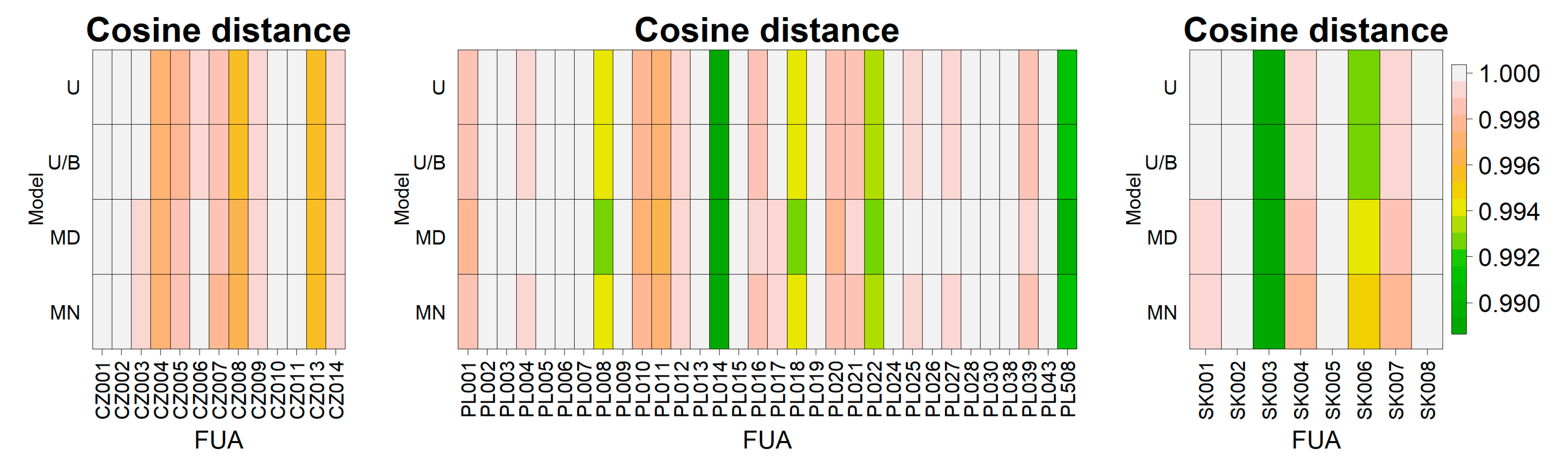
3. Results
4. Discussion
5. Conclusions
Author Contributions
Funding
Acknowledgments
Conflicts of Interest
References
- Population Division, Department of Economic and Social Affairs, United Nation. World Urbanization Prospects: The 2018 Revision, Online Edition. 2018. Available online: https://esa.un.org/unpd/wup/ (accessed on 24 March 2020).
- Pesaresi, M.; Melchiorri, M.; Siragusa, A.; Kemper, T. Atlas of the Human Planet—Mapping Human Presence on Earth with the Global Human Settlement Layer; JRC10315; Publications Office of the European Union, European Commission: Luxembourg, 2016. Available online: https://ec.europa.eu/jrc/en/publication/eur-scientific-and-technical-research-reports/atlas-human-planet-mapping-human-presence-earth-global-human-settlement-layer (accessed on 28 November 2020).
- Angel, S.; Lamson-Hall, P.; Guerra, B.; Liu, Y.; Galarza, N.; Blei, A.M. Our Not-So-Urban World; The Marron Institute of Urban Management, New York University: New York, NY, USA, 2018. [Google Scholar]
- Terama, E.; Clarke, E.; Rounsevell, M.; Fronzek, S.; Carter, T.R. Modelling population structure in the context of urban land use change in Europe. Reg. Environ. Chang. 2019, 19, 667–677. [Google Scholar] [CrossRef]
- United Nations. The Components of Urban Growth in Developing Countries. 2001. Available online: https://population.un.org/wup/Archive/Files/studies/United%20Nations%20(2001)%20-%20The%20Components%20of%20Urban%20Growth%20in%20Developing%20Countries.pdf (accessed on 13 December 2020).
- Ahrens, A.; Lyons, S. Changes in Land Cover and Urban Sprawl in Ireland from a Comparative Perspective Over 1990–2012. Land 2019, 8, 16. [Google Scholar] [CrossRef]
- Di Gregorio, A.; Jansen, L. Land Cover Classification System (Lccs): Classification Concepts and User Manual; FAO: Rome, Italy, 2000; Available online: http://www.fao.org/3/x0596e/X0596e00.htm#P-1_0 (accessed on 28 November 2020).
- Bičík, I.; Kupková, L.; Jeleček, L.; Kabrda, J.; Štych, P.; Janoušek, Z.; Winklerová, J. Land Use Changes in the Czech Republic 1845–2010: Socio Economic Driving Forces; Springer: Cham, Switzerland, 2015. [Google Scholar]
- Bičík, I.; Jeleček, L.; Štěpánek, V. Land-use changes and their social driving forces in Czechia in the 19th and 20th centuries. Land Use Policy 2001, 18, 65–73. [Google Scholar] [CrossRef]
- Lambin, E.F.; Turner, B.L.; Geist, H.J.; Agbola, S.B.; Angelsen, A.; Bruce, J.W.; Coomes, O.T.; Dirzo, R.; Fischer, G.; Folke, C.; et al. The causes of land-use and land-cover change: Moving beyond the myths. Glob. Environ. Chang. 2001, 11, 261–269. [Google Scholar] [CrossRef]
- Jelecek, L. Historical development of society and LUCC in Czechia 1800–2000: Major societal driving forces of land use changes. In Land Use/Land Cover Changes in the Period of Globalisation; Bičik, I., Chromy, P., Jancak, V., Janu, H., Eds.; Geography and Regional Development: Prague, Czech Republic, 2001; pp. 44–57. [Google Scholar]
- Wubie, M.A.; Assen, M.; Nicolau, M.D. Patterns, causes and consequences of land use/cover dynamics in the Gumara watershed of lake Tana basin, Northwestern Ethiopia. Environ. Syst. Res. 2016, 5, 8. [Google Scholar] [CrossRef]
- Brandt, J.; Primdahl, J.; Reenberg, A. Rural land-use and dynamic forces—Analysis of ‘driving forces’ in space and time. In Land-Use Changes and Their Environmental Impact in Rural Areas in Europe; Krönert, R., Baudry, J., Bowler, I.R., Reenberg, A., Eds.; UNESCO: Paris, France, 1999; pp. 81–102. [Google Scholar]
- Bürgi, M.; Hersperger, A.M.; Schneeberger, N. Driving forces of landscape change-current and new directions. Landsc. Ecol. 2005, 19, 857–868. [Google Scholar] [CrossRef]
- Lambin, E.F.; Meyfroidt, P. Land use transitions: Socio-ecological feedback versus socio-economic change. Land Use Policy 2010, 27, 108–118. [Google Scholar] [CrossRef]
- Geist, H.; Lambin, E. Proximate Causes and Underlying Driving Forces of Tropical Deforestation: Tropical forests are disappearing as the result of many pressures, both local and regional, acting in various combinations in different geographical locations. BioScience 2002, 52, 143–150. [Google Scholar] [CrossRef]
- Lambin, E.F.; Geist, H.J. (Eds.) Land-Use and Land-Cover Change: Local Processes and Global Impacts; Springer: Berlin/Heidelberg, Germany, 2008. [Google Scholar]
- Hersperger, A.M.; Oliveira, E.; Pagliarin, S.; Palka, G.; Verburg, P.; Bolliger, J.; Grădinaru, S. Urban land-use change: The role of strategic spatial planning. Glob. Environ. Chang. 2018, 51, 32–42. [Google Scholar] [CrossRef]
- Szylar, M.; Cegielska, K.; Kudas, D.; Czesak, B. Spatial planning and local flood protection planning as a tool for flood hazard limitation—Case study. Electron. J. Pol. Agric. Univ. 2019, 22. [Google Scholar] [CrossRef]
- Grežo, H.; Močko, M.; Izsóff, M.; Vrbičanová, G.; Petrovič, F.; Straňák, J.; Muchová, Z.; Slámová, M.; Olah, B.; Machar, I. Flood Risk Assessment for the Long-Term Strategic Planning Considering the Placement of Industrial Parks in Slovakia. Sustainability 2020, 12, 4144. [Google Scholar] [CrossRef]
- Dale, V.H.; Oneill, R.V.; Pedlowski, M.; Southworth, F. Causes and effects of land-use change in central Rondonia, Brazil. Photogramm. Eng. Remote Sens. 1993, 59, 997–1005. [Google Scholar]
- Linderman, M.A.; An, L.; Bearer, S.; He, G.; Ouyang, Z.; Liu, J. Modeling the spatio-temporal dynamics and interactions of households, landscapes, and giant panda habitat. Ecol. Model. 2005, 183, 47–65. [Google Scholar] [CrossRef]
- Munteanu, C.; Kuemmerle, T.; Boltiziar, M.; Butsic, V.; Gimmi, U.; Halada, L.; Kaim, D.; Király, G.; Konkoly-Gyuró, É.; Kozak, J.; et al. Forest and agricultural land change in the Carpathian region—A meta-analysis of long-term patterns and drivers of change. Land Use Policy 2014, 38, 685–697. [Google Scholar] [CrossRef]
- Eurostat. Statistics Explained. Glossary: Functional Urban Area. Available online: https://ec.europa.eu/eurostat/statistics-explained/index.php/Glossary:Functional_urban_area (accessed on 14 December 2020).
- Feranec, J.; Hazeu, G.; Christensen, S.; Jaffrain, G. Corine land cover change detection in Europe (case studies of the Netherlands and Slovakia). Land Use Policy 2007, 24, 234–247. [Google Scholar] [CrossRef]
- Feranec, J.; Jaffrain, G.; Soukup, T.; Hazeu, G. Determining changes and flows in European landscapes 1990–2000 using CORINE land cover data. Appl. Geogr. 2010, 30, 19–35. [Google Scholar] [CrossRef]
- Pazúr, R.; Feranec, J.; Štych, P.; Kopecká, M.; Holman, L. Changes of urbanised landscape identified and assessed by the Urban Atlas data: Case study of Prague and Bratislava. Land Use Policy 2017, 61, 135–146. [Google Scholar] [CrossRef]
- Grigg, D. An Introduction to Agricultural Geography; Routledge: London, UK, 1995. [Google Scholar]
- Rodgers, S. Urban geography: Urban growth machine. In The International Encyclopedia of Human Geography; Kitchin, R., Thrift, N., Eds.; Elsevier: Oxford, UK, 2009; Volume 12, pp. 40–45. [Google Scholar]
- Logan, J.R.; Molotch, H.L. Urban Fortunes: The Political Economy of Place; University of California Press: Berkeley, CA, USA, 2007. [Google Scholar]
- Kuemmerle, T.; Levers, C.; Erb, K.; Estel, S.; Jepsen, M.R.; Müller, D.; Plutzar, C.; Stürck, J.; Verkerk, P.J.; Verburg, P.H.; et al. Hotspots of land use change in Europe. Environ. Res. Lett. 2016, 11, 064020. [Google Scholar] [CrossRef]
- Rozelle, S.; Swinnen, J.F.M. Success and Failure of Reform: Insights from the Transition of Agriculture. J. Econ. Lit. 2004, 42, 404–456. [Google Scholar] [CrossRef]
- Schierhorn, F.; Müller, D.; Beringer, T.; Prishchepov, A.V.; Kuemmerle, T.; Balmann, A. Post-Soviet cropland abandonment and carbon sequestration in European Russia, Ukraine, and Belarus. Glob. Biogeochem. Cycles 2013, 27, 1175–1185. [Google Scholar] [CrossRef]
- Augustyn, M. Anthropogenic pressure in the environmental parameters of the Bieszczady Mountains. Biosph. Conserv. 2004, 6, 43–53. [Google Scholar]
- Griffiths, P.; Müller, D.; Kuemmerle, T.; Hostert, P. Agricultural land change in the Carpathian ecoregion after the breakdown of socialism and expansion of the European Union. Environ. Res. Lett. 2013, 8, 045024. [Google Scholar] [CrossRef]
- Estel, S.; Kuemmerle, T.; Alcántara, C.; Levers, C.; Prishchepov, A.V.; Hostert, P. Mapping farmland abandonment and recultivation across Europe using MODIS NDVI time series. Remote Sens. Environ. 2015, 163, 312–325. [Google Scholar] [CrossRef]
- Janus, J.; Bożek, P. Land abandonment in Poland after the collapse of socialism: Over a quarter of a century of increasing tree cover on agricultural land. Ecol. Eng. 2019, 138, 106–117. [Google Scholar] [CrossRef]
- Łowicki, D. Land use changes in Poland during transformation: Case study of Wielkopolska region. Lands. Urban Plan. 2008, 87, 279–288. [Google Scholar] [CrossRef]
- Cegielska, K.; Noszczyk, T.; Kukulska, A.; Szylar, M.; Hernik, J.; Dixon-Gough, R.; Jombach, S.; Valánszki, I.; Kovács, K.F. Land use and land cover changes in post-socialist countries: Some observations from Hungary and Poland. Land Use Policy 2018, 78, 1–18. [Google Scholar] [CrossRef]
- Kukulska, A.; Szylar, M.; Cegielska, K.; Noszczyk, T.; Hernik, J.; Gawroński, K.; Dixon-Gough, R.; Jombach, S.; Valánszki, I.; Kovács, K.F. Towards three decades of spatial development transformation in two contrasting post-Soviet cities—Kraków and Budapest. Land Use Policy 2019, 85, 328–339. [Google Scholar] [CrossRef]
- Kanianska, R.; Kizeková, M.; Nováček, J.; Zeman, M. Land-use and land-cover changes in rural areas during different political systems: A case study of Slovakia from 1782 to 2006. Land Use Policy 2014, 36, 554–566. [Google Scholar] [CrossRef]
- Pazúr, R.; Bolliger, J. Land changes in Slovakia: Past processes and future directions. Appl. Geogr. 2017, 85, 163–175. [Google Scholar] [CrossRef]
- Biró, M.; Czúcz, B.; Horváth, F.; Révész, A.; Csatári, B.; Molnár, Z. Drivers of grassland loss in Hungary during the post-socialist transformation (1987–1999). Landsc. Ecol. 2012, 28, 789–803. [Google Scholar] [CrossRef]
- Iváncsics, V.; Kovács, K.F. Characteristics of Post Socialist Spatial Development of the Functional Urban Area of Veszprém, Hungary. J. Environ. Geogr. 2019, 12, 33–43. [Google Scholar] [CrossRef]
- Statistics Poland. Available online: https://stat.gov.pl/en/ (accessed on 10 July 2020).
- Statistical Office of the Slovak Republic. Available online: http://statdat.statistics.sk/ (accessed on 10 July 2020).
- Czech Statistical Office. Available online: https://www.czso.cz/ (accessed on 10 July 2020).
- Organisation for Economic Co-operation and Development (OECD) Staff. Land-Use Planning Systems in the OECD: Country Fact Sheet; OECD Publishing: Paris, France, 2017. [Google Scholar] [CrossRef]
- Veldkamp, A.; Fresco, L.O. CLUE: A conceptual model to study the Conversion of Land Use and its Effects. Ecol. Model. 1996, 85, 253–270. [Google Scholar] [CrossRef]
- Veldkamp, A.; Fresco, L.O. CLUE-CR: An integrated multi-scale model to simulate land use change scenarios in Costa Rica. Ecol. Model. 1996, 91, 231–248. [Google Scholar] [CrossRef]
- Veldkamp, A.; Verburg, P.H. Modelling land use change and envir-onmental impact. J. Environ. Manag. 2004, 72, 1–3. [Google Scholar] [CrossRef] [PubMed]
- Parker, D.C.; Manson, S.M.; Janssen, M.A.; Hoffmann, M.J.; Deadman, P. Multi-agent systems for the simulation of land use and land usechange: A review. Ann. Assoc. Am. Geogr. 2003, 93, 314–337. [Google Scholar] [CrossRef]
- Noszczyk, T.; Rutkowska, A.; Hernik, J. Exploring the land use changes in Eastern Poland: Statistics-based modeling. Hum. Ecol. Risk Assess. Int. J. 2020, 26, 255–282. [Google Scholar] [CrossRef]
- Agarwal, C.; Green, G.M.; Grove, J.M.; Evans, T.P.; Schweik, C.M. A Review and Assessment of Land-Use Change Models: Dynamics of Space, Time, and Human Choice; US Dept. of Agriculture, Forest Service, Northeastern Research Station: Newtown Square, PA, USA, 2002; pp. 12–27. [Google Scholar]
- Brown, D.G.; Verburg, P.H.; Pontius, R.G., Jr.; Lange, M.D. Opportunities to improve impact, integration, and evaluation of land change models. Curr. Opin. Environ. Sustain. 2013, 5, 452–457. [Google Scholar] [CrossRef]
- Noszczyk, T. A review of approaches to land use changes modeling. Hum. Ecol. Risk Assess. Int. J. 2019, 25, 1377–1405. [Google Scholar] [CrossRef]
- Brown, D.G.; Walker, R.; Manson, S.; Seto, K. Modeling land use and land cover change. In Land Change Science; Springer: Dordrecht, The Netherlands, 2012; pp. 395–409. [Google Scholar]
- Seto, K.C.; Kaufmann, R.K. Modeling the drivers of urban land use changein the Pearl River Delta, China: Integrating remote sensing with socioeconomicdata. Land Econ. 2003, 79, 106e121. [Google Scholar] [CrossRef]
- Yu, W.; Zang, S.; Wu, C.; Liu, W.; Na, X. Analysing and modeling land use land cover change (LUCC) in the Daqing City, China. Appl. Geogr. 2011, 31, 600–608. [Google Scholar] [CrossRef]
- Veldkamp, A.; Lambin, E. Predicting land-use change. Agric. Ecosyst. Environ. 2001, 85, 1–6. [Google Scholar] [CrossRef]
- Cegielska, K.; Kudas, D.; Różycka-Czas, R.; Salata, T.; Szylar, M. The analysis of land cover macrostructure in the suburban area of Krakow. Geomat. Landmanag. Landsc. 2017, 2, 47–60. [Google Scholar] [CrossRef]
- Tokarczyk-Dorociak, K.; Kazak, J.K.; Szewrański, S. The Impact of a Large City on Land Use in Suburban Area—The Case of Wrocław (Poland). J. Ecol. Eng. 2018, 19, 89–98. [Google Scholar] [CrossRef]
- Wnęk, A.; Kudas, D.; Halva, J.; Krakowie, U.R.W. Slovak University of Agriculture in Nitra Analysis of Changes in Land Cover Structure Using Ring-Shaped Polygons of Evaluation, on The Example of Selected Areas of Slovakia, Poland and The Czech Republic. Geomat. Landmanag. Landsc. 2019, 1, 45–56. [Google Scholar] [CrossRef]
- European Environment Agency. Copernicus Land Monitoring Service—Urban Atlas. Available online: https://www.eea.europa.eu/data-and-maps/data/copernicus-land-monitoring-service-urban-atlas (accessed on 12 December 2020).
- CORINE Land Cover. Available online: https://land.copernicus.eu/pan-european/corine-land-cover (accessed on 20 May 2020).
- Muchová, Z.; Tárníková, M. Land Cover Change and Its Influence on The Assessment of The Ecological Stability. Appl. Ecol. Environ. Res. 2018, 16, 5169–5182. [Google Scholar] [CrossRef]
- European Commission. Urban Atlas 2006. Download. FUA Delivery Report. Available online: https://land.copernicus.eu/local/urban-atlas/urban-atlas-2006?tab=download (accessed on 8 February 2020).
- European Commission. Urban Atlas 2012. Download. FUA Delivery Report. Available online: https://land.copernicus.eu/local/urban-atlas/urban-atlas-2012?tab=download (accessed on 8 February 2020).
- European Commission. Urban Atlas 2012 Mapping Guide. v4.7. 2016. Available online: https://land.copernicus.eu/user-corner/technical-library/urban-atlas-mapping-guide (accessed on 8 February 2020).
- Healy, M.J.R. Multivariate Normal Plotting. Appl. Stat. 1968, 17, 157–161. [Google Scholar] [CrossRef]
- Martos, G.; Muñoz, A.; González, J. On the Generalisation of the Mahalanobis Distance. In Progress in Pattern Recognition, Image Analysis, Computer Vision, and Applications; Ruiz-Shulcloper, J., Sanniti di Baja, G., Eds.; CIARP 2013; Lecture Notes in Computer Science; Springer: Berlin/Heidelberg, Germany, 2013; Volume 8258. [Google Scholar] [CrossRef]
- Filzmoser, P.; Maronna, R.A.; Werner, M. Outlier identification in high dimensions. Comput. Stat. Data Anal. 2008, 52, 1694–1711. [Google Scholar] [CrossRef]
- Trzęsiok, J. Outliers vs Robustness in Nonparametric Methods of Regression. Acta Univ. Lodz. Folia Oecon. 2018, 4, 99–109. [Google Scholar] [CrossRef]
- R Core Team. R: A Language and Environment for Statistical Computing; R Foundation for Statistical Computing. 2019. Available online: https://www.R-project.org/ (accessed on 25 March 2020).
- Nychka, D.; Furrer, R.; Paige, J.; Sain, S. Fields: Tools for Spatial Data; R Package Version 10.0. 2017. Available online: https://doi.org/10.5065/D6W957CT (accessed on 25 March 2020).
- Drost, H.-G. Philentropy: Information Theory and Distance Quantification with R. J. Open Source Softw. 2018, 3, 765. [Google Scholar] [CrossRef]
- Łowicki, D.; Mizgajski, A. Typology of physical-geographical regions in Poland in line with land-cover structure and its changes in the years 1990–2006. Geogr. Pol. 2013, 86, 255–266. [Google Scholar] [CrossRef]
- Nalej, M. Agricultural land cover changes in metropolitan areas of Poland for the period 1990–2012. Misc. Geogr. 2016, 20, 39–45. [Google Scholar] [CrossRef][Green Version]
- Antrop, M. Landscape change and the urbanization process in Europe. Landsc. Urban Plan. 2004, 67, 9–26. [Google Scholar] [CrossRef]


| Classes | Country | ||
|---|---|---|---|
| Czechia | Poland | Slovakia | |
| (%) LUC in the Class | |||
| 1 | 0.57 | 0.81 | 0.40 |
| 2 | −0.57 | −0.77 | −0.37 |
| 3 | −0.04 | −0.06 | −0.03 |
| 5 | 0.04 | 0.02 | 0.00 |
| Classes | Country | ||
|---|---|---|---|
| Czechia | Poland | Slovakia | |
| (%) LUC in the Class | |||
| 11100 | 0.02 | 0.01 | 0.01 |
| 11210 | 0.02 | 0.02 | 0.03 |
| 11220 | 0.01 | 0.03 | 0.02 |
| 11230 | 0.05 | 0.05 | 0.02 |
| 11240 | 0.19 | 0.28 | 0.08 |
| 11300 | 0.00 | 0.04 | 0.01 |
| 12100 | 0.15 | 0.13 | 0.13 |
| 12210 | 0.02 | 0.05 | 0.01 |
| 12220 | 0.01 | 0.02 | 0.02 |
| 12230 | 0.00 | 0.00 | 0.00 |
| 12300 | 0.00 | 0.00 | 0.00 |
| 12400 | 0.00 | 0.00 | 0.00 |
| 13100 | 0.03 | 0.06 | 0.03 |
| 13300 | 0.01 | 0.08 | 0.03 |
| 13400 | 0.01 | 0.02 | 0.01 |
| 14100 | −0.01 | 0.00 | 0.00 |
| 14200 | 0.04 | 0.01 | 0.01 |
| Country | Model | (‰) LUC in the Class | LUC Dynamics (‰) | ||
|---|---|---|---|---|---|
| Class 1 | Class 2 | Class 3 | |||
| Czechia | WMN | 5.3111 | −5.3306 | −0.2951 | 7.5306 |
| WMD | 5.1642 | −5.1762 | −0.2894 | 7.3175 | |
| WU/B | 5.5916 | −5.5304 | −0.3164 | 7.8709 | |
| WU | 6.2935 | −6.2314 | −0.3066 | 8.8619 | |
| Poland | WMN | 7.8758 | −7.5254 | −0.5091 | 10.9050 |
| WMD | 7.5953 | −7.4274 | −0.3814 | 10.6302 | |
| WU/B | 7.9744 | −7.6279 | −0.5229 | 11.0477 | |
| WU | 6.9290 | −6.6227 | −0.4878 | 9.5974 | |
| Slovakia | WMN | 4.1752 | −3.8478 | −0.3769 | 5.6904 |
| WMD | 3.1920 | −2.9896 | −0.2966 | 4.3834 | |
| WU/B | 4.1107 | −3.7311 | −0.4262 | 5.5679 | |
| WU | 4.8297 | −4.5449 | −0.3515 | 6.6412 | |
Publisher’s Note: MDPI stays neutral with regard to jurisdictional claims in published maps and institutional affiliations. |
© 2021 by the authors. Licensee MDPI, Basel, Switzerland. This article is an open access article distributed under the terms and conditions of the Creative Commons Attribution (CC BY) license (http://creativecommons.org/licenses/by/4.0/).
Share and Cite
Wnęk, A.; Kudas, D.; Stych, P. National Level Land-Use Changes in Functional Urban Areas in Poland, Slovakia, and Czechia. Land 2021, 10, 39. https://doi.org/10.3390/land10010039
Wnęk A, Kudas D, Stych P. National Level Land-Use Changes in Functional Urban Areas in Poland, Slovakia, and Czechia. Land. 2021; 10(1):39. https://doi.org/10.3390/land10010039
Chicago/Turabian StyleWnęk, Agnieszka, Dawid Kudas, and Premysl Stych. 2021. "National Level Land-Use Changes in Functional Urban Areas in Poland, Slovakia, and Czechia" Land 10, no. 1: 39. https://doi.org/10.3390/land10010039
APA StyleWnęk, A., Kudas, D., & Stych, P. (2021). National Level Land-Use Changes in Functional Urban Areas in Poland, Slovakia, and Czechia. Land, 10(1), 39. https://doi.org/10.3390/land10010039