Article

An Examination of Soil Moisture Estimation Using Ground Penetrating Radar in Desert Steppe

1
China Institute of Water Resources and Hydropower Research, Beijing 100038, China
2
Research Center on Flood & Drought Disaster Reduction of the Ministry of Water Resources, Beijing 100038, China
*
Author to whom correspondence should be addressed.
Water 2017, 9(7), 521; https://doi.org/10.3390/w9070521
Submission received: 5 May 2017 / Revised: 3 July 2017 / Accepted: 10 July 2017 / Published: 22 July 2017

Abstract

:
Ground penetrating radar (GPR) is a new technique of rapid soil moisture measurement, which is an important approach to measure soil moisture at the intermediate scale. To test the applicability of GPR method for soil moisture in desert steppe, we used the common-mid point (CMP) method and fixed offset (FO) method to evaluate the influence factors and the accuracy of GPR measurement with gravimetric soil moisture measurements. The experiments showed that Topp’s equation is more suitable than Roth’s equation for processing the GPR data in desert steppe and the soil moisture measurements by GPR had high accuracy by either CMP method or FO method. To a certain extent, the vegetation coverage affects the measurement precision and the soil moisture profile. The precipitation can reduce the effective sampling depth of the ground wave from 0.1 m to 0.05 m. The results revealed that GPR has the advantages of high measurement accuracy, easy movement, simple operation, and no damage to the soil layer structure.

1. Introduction

Soil water is the basis of vegetation development, and soil moisture is an important indicator of climate, hydrology, ecology, and agriculture. The spatial and temporal distribution of soil moisture has a significant impact on precipitation infiltration, runoff, and other hydrological processes. In the desert steppe, soil moisture is the main factor that controls the vegetation growth and restoration, and it is the main factor to affect the ecosystem degradation and reversion. The monitoring of soil moisture in desert steppe is important to protect grassland vegetation, prevent desertification, improve the ecological environment, and provide the basis for grazing control and the prevention of grassland degradation.
Measurement technology of soil moisture can be roughly divided into three types according to the measuring scale. The first is the point scale method, including the gravimetric method, neutron method, TDR, FDR, and so on. The data determined by these methods can reflect the soil moisture of the observation point accurately, but it is time-consuming and laborious with destructive problems to the soil structure. Second, the intermediate scale method includes GPR and CRS. These are non-hazardous, non-contact, and non-destructive measurement methods that develop rapidly. The third is the coarser scale method mainly composed of satellite platforms. The point scale methods of measuring soil moisture are not capable of collecting large scale data rapidly. The remote sensing methods have the advantage of large coverage and repeated observations on a regular basis but at coarse scales [1]. Ground penetrating radar (GPR), as a nondestructive geophysical methods, has the ability to monitor soil moisture bridging the scale gap between point and remote sensing measurements, and to quantify the spatial variation of soil moisture [2]. The non-invasive character of GPR offers the mobility needed to map soil water content of large areas (up to 500 m × 500 m a day) [3]. GPR method for measuring soil moisture is widely used in irrigation experiments [4], monitoring soil moisture dynamic [5,6,7], agriculture [8,9,10], and observation of long time series [11,12]. FO method, CMP method, and Wide angle reflection and refraction (WARR) method are the three commonly used methods of GPR. By WARR and CMP methods, soil moisture can be estimated easily. However, measurements by WARR and CMP methods have low spatial resolution and require more time. FO method has the advantage of faster measurement and higher resolution by towing the antenna with a vehicle [4], but it is difficult to calibrate time zero and identify ground direct wave. Many studies on GPR method of soil moisture measurement by scholars have been carried out in the world. Grote [8] used CMP method to measure soil moisture by 450 MHz and 900 MHz GPR, and found an RMSE of 0.022 m3/m3 and 0.015 m3/m3, respectively. Huisman [13], Galagedara [4], and Weihermller [14] studied the optimum antenna spacing of FO method to separate ground direct wave from airwave by WARR method or CMP method. Huisman [13] and Weihermller [14] compared 225 MHz and 450 MHZ GPR with TDR to measure soil moisture, concluding that the soil moisture obtained by FO method had an RMSE of 0.018 m3/m3 and 0.011 m3/m3, respectively. Lunt [15] compared FO method by 100 MHz GPR with the neutron method and got an RMSE of 0.018 m3/m3. Stoffregen [16] extracted reflected wave to estimate soil moisture by 1 GHz GPR and got a standard deviation of 0.01 m3/m3 compared with lysimeter data. However, there is less research on GPR measurement of soil moisture applied in China area. Instead, there are more studies on GPR simulation experiments conducted by Chinese researchers. For example, Wang [17] used WARR method to determine the optimum antenna spacing of FO method and applied FO method to estimate soil moisture over large areas by 200 MHz GPR in arid area of China. Wang [17] found a deviation of only 0.015 m3/m3 and an effective depth of 0.20 m compared with TDR results. Qin [18] used 200 MHz GPR to monitor the spatial change of soil water before and after snow melt in desert, and the absolute error of GPR measurement was less than 0.03 m3/m3 compared with TDR results. Guo [19], Ma [20], and Li [21] studied on the relationship between soil moisture and GPR signal attributes by simulation experiments.
Research on GPR application for different soil types is still in the initial stage, and mainly used in laboratory test or in the desert area [22,23,24,25], and there is no research to focus on the applicability of soil water measurement by GPR in the desert steppe region. This research used the CMP method and FO method of GPR to measure soil moisture in desert steppe, verifying the measurement accuracy by gravimetric method synchronously. The application in different land cover types was also analyzed. The specific objective of this research was to study the suitability of monitoring soil moisture by GPR and its influencing factors for desert steppe: (1) To choose a more appropriate formula from Topp’s equation and Roth’s equation for calculating soil moisture in desert steppe; (2) To assess the accuracy of CMP and FO methods in desert steppe; (3) To analyze the influencing factors of GPR measurement in desert steppe. Research on the real-time monitoring of soil moisture in desert steppe contributes to the vegetation protection, and helps to prevent soil desertification and protect functional ecosystems. It also provides technical support for remote sensing calibration of soil moisture, agricultural production, and ecological restoration for desert steppe.

2. Materials and Methods
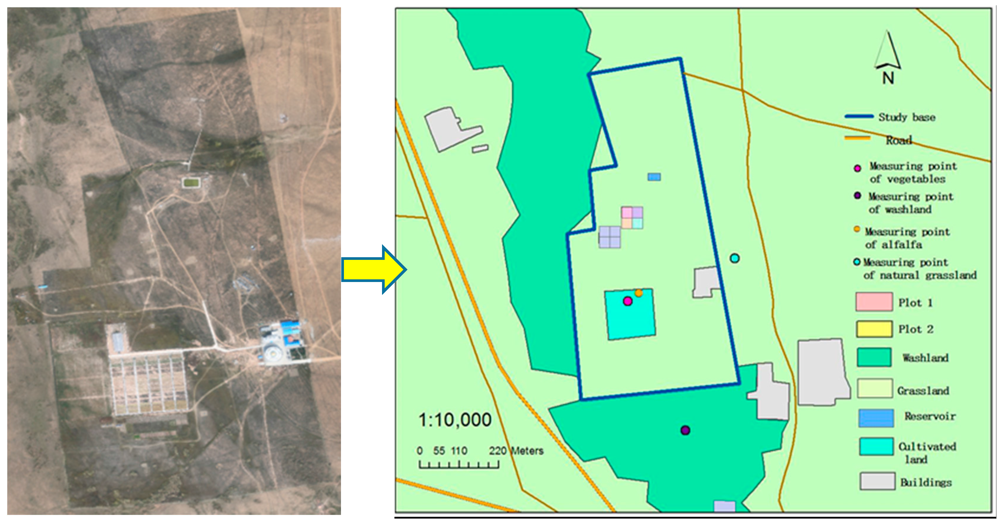
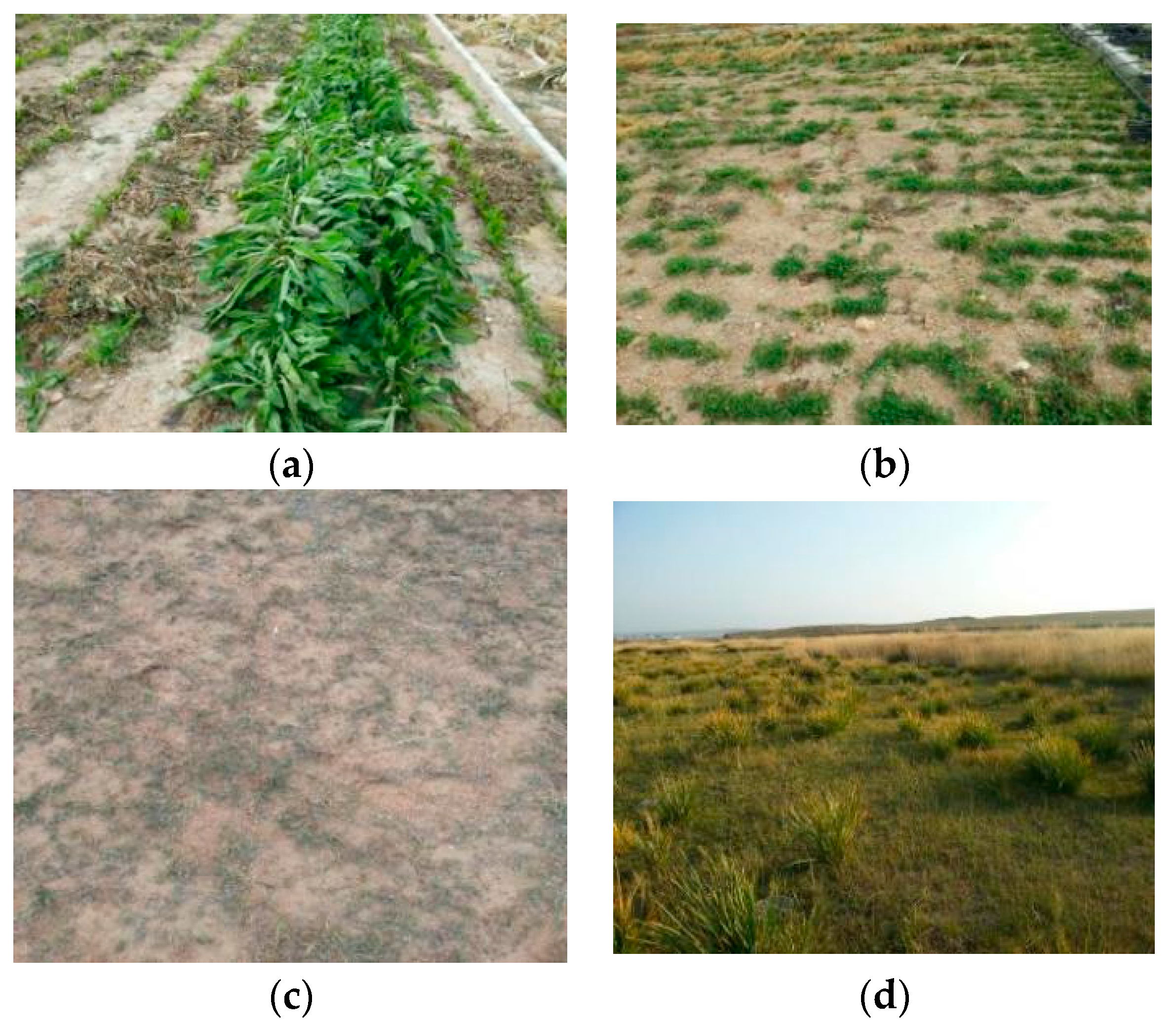
2.1. Study Site

The study was carried out at the experimental base of Institute of Water Resources for Pastoral in Xilamuren Town, Baotou City, Inner Mongolia region (41°22′ N, 111°12′ E). The base nearing the south of Tabu River covers an area of 150 hectares with the highest elevation of 1690.3 m and the lowest elevation of 1585.0 m. The study area belongs to the temperate semi-arid continental monsoon climate. The average annual precipitation is 284 mm, the average annual evaporation is 2305 mm, and the annual average temperature is 2.5 °C. The study area with the zonal soil of Kastanozems is located in the Wulanchabu desert steppe of central Inner Mongolia Region. The local vegetation in the base showing typical steppe characteristics is not disturbed from grazing and human activities (Figure 1). The vegetation edificator in the study area is Stipa krylovii, the dominant species is Leymus chinensis, and other important species are Artemisia frigida, Cleistogenes, Agropyron cristatum, etc.

2.2. GPR Theory

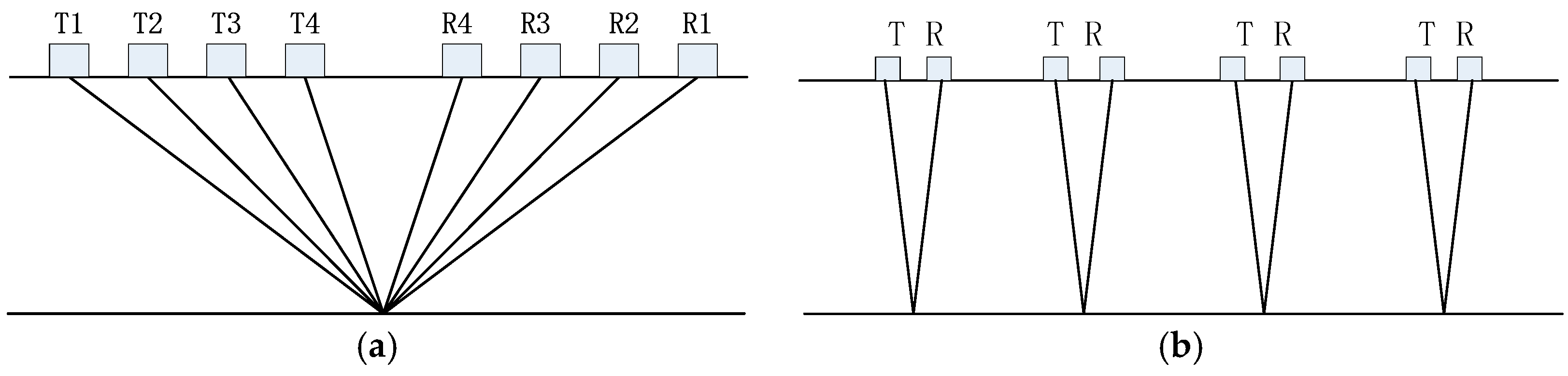
2.2.1. Measuring Principle

Ground penetrating radar (GPR) is an electromagnetic detection technology which uses the high frequency electromagnetic wave to detect the inner structure and the characteristic of buildings in the center frequency ranging from 10 MHZ to 3 GHZ [15]. The electromagnetic wave received by the receiving transducer is divided into air wave, ground wave, reflected wave, and refraction wave. The propagation speed of radar waves in unsaturated soil depends on its relative dielectric constant. The velocity of ground wave and reflected wave can be extracted from GPR data to calculate relative dielectric constant of the soil. Then soil moisture can be obtained by the relationship between soil moisture and its relative dielectric constant. The depth of soil moisture is determined by the corresponding sampling depth of ground wave or reflected wave. In the low loss medium, the relationship between the electromagnetic wave velocity v and the relative dielectric constant K is
K = (c/v)2
where c is the propagation velocity of electromagnetic wave in vacuum [26] and v is the electromagnetic wave velocity in the low loss medium. The relationship between soil moisture constants (θ) and relative dielectric constant of the soil (ε) can be described by the empirical formula, semi theoretical formula. This study used two common empirical formulas which are Topp’s equation [27] and Roth’s equation [28] to calculate soil water content
Topp’s equation: θ = −0.053 + 0.0293ε − 0.00055ε2 + 0.0000043ε3
Roth’s equation: θ = −0.078 + 0.0448ε − 0.00195ε2 + 0.0000361ε3
The effective depth of the soil water content calculated by the ground direct wave is related to the antenna frequency and soil type, which has not been clearly defined. However, some research attempted to establish the empirical formula of the effective depth of the ground direct wave, in which Sperl (1999) [29] proposed the function of the effective depth Z and radar wave length λ.
Z 0.145 λ 1 / 2
The experimental results of Huisman [3] showed that the effective depth of 225 MHZ and 450 MHZ GPR is 0.10 m, which is consistent with the conclusion of Sperl [29].
The measuring depth of the soil moisture by reflected wave is the sampling depth of reflection wave. When the soil moisture is calculated by the reflection wave velocity, the reflection layer is assumed continuous, horizontal, and with a clear interface. In this study, the soil profile structure was obtained by FO method, and the reflected wave velocity was measured by CMP method, and then the depth of the reflection layer was calculated.

2.2.2. GPR Methods

GPR can obtain relative dielectric constant of the soil by extracting the information of radar waves, and then retrieve the soil moisture content. According to the different measuring mode of GPR, the GPR method is mainly divided into the multi-offset reflection method (including CMP and WARR methods), FO method, surface reflection method, and transillumination method [30,31]. On the basis of obvious layered soil structure in study area, we applied the CMP method of GPR to soil moisture measurement, and FO method to obtain the soil profile structure. The CMP method is the measuring method in which the center point of the antennas is fixed and the receiving and transmitting antennas move in opposite directions at the same distance synchronously from the center point of the antennas (Figure 2) [32]. CMP method measures the propagation velocity of direct wave and reflected wave directly for soil moisture calculation with high accuracy and different depth. FO method is a method that the receiving and transmitting antenna spacing is fixed and moving at the same interval. (Figure 2) [32]. The soil profile structure in the study area can be obtained by FO method, which can be used to determine the soil layer, and combined with the results of the CMP method to determine the depth of the soil moisture content. When the appropriate antenna spacing of FO method is set, the ground direct wave and the airwave can be separated. Then the soil relative permittivity is calculated by antenna spacing (x), ground direct wave arrival time (tGW), and airwave arrival time (tAW) using the Formula (5) to estimate the soil moisture. The measured depth of FO method is the sampling depth of the ground wave.
ε = ( c v ) 2 = ( c ( t G W t A W ) + x x ) 2

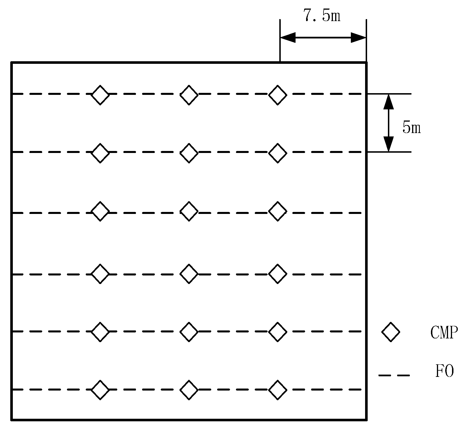
2.3. Data Acquisition

Measurements were mainly carried out in two 30 m × 30 m plots chosen in the study area (named Plot 1 and Plot 2 in Figure 1) which had flat terrain, uniform underlying surface condition, and differences in vegetation growth. On 11 June 2015, 6 CMP measurements were collected in the middle of each row after raining in each plot. On 20 September 2015, we collected 18 measurements spaced 7.5 m apart by CMP method along six transects in each plot (Figure 3). We also selected two measuring points with exuberant vegetation in the Plot 2 measuring the soil moisture before and after weeding, and four measuring points of different land cover types (vegetables, alfalfa, natural grassland, washland; Figure 1) in the experimental area to obtain soil moisture by CMP method. The six transects of 30 m spaced 5 m apart along six rows were set for FO method. We used FO method to obtain soil structure on 20 September 2015 and measure soil moisture on 24 August 2016.
Higher frequencies have higher spatial resolutions and a higher attenuation which lead to a lower depth of penetrating. This study intended to obtain soil moisture at different depths, so the selected frequency of GPR should not be too high. Considering the portability of GPR and the feature of FO method, a high-frequency antenna with wheels should be used to improve the measuring efficiency of FO method. For the above reasons, this study used the pulse EKKO PRO GPR at a center frequency of 250 MHZ produced by Sensors & Software, a Canadian company, mainly consisting of the transmitting antenna, the receiving antenna, the Digital Video logger (DVL) and control module. The CMP measurements were made with antenna separations increasing from 0.38 m to 5.38 m with increments of 0.10 m, a time window of 100 ns, a sampling interval of 0.4 ns, and 32 stacks per trace. The collection parameters of FO method for soil structure included an antenna separation of 0.38 m, a sampling interval of 0.4 ns, trace spacing of 0.05 m, and 32 stacks per trace at each location to improve the signal to noise ratio. FO method for soil moisture measurement changed the antenna spacing to 1.5 m and other parameters remained the same. According to the Formula (4), the effective depth of 250 MHZ GPR ground direct wave is about 0.10 m. Combined with the research results of Huisman, we selected the soil moisture measurements of 0.10 m depth from gravimetric method for accuracy verification of GPR ground direct wave. Therefore, soil samples were collected adjacent to the locations of measuring points for CMP method at the depth of 0.10 m.

3. Results and Discussion

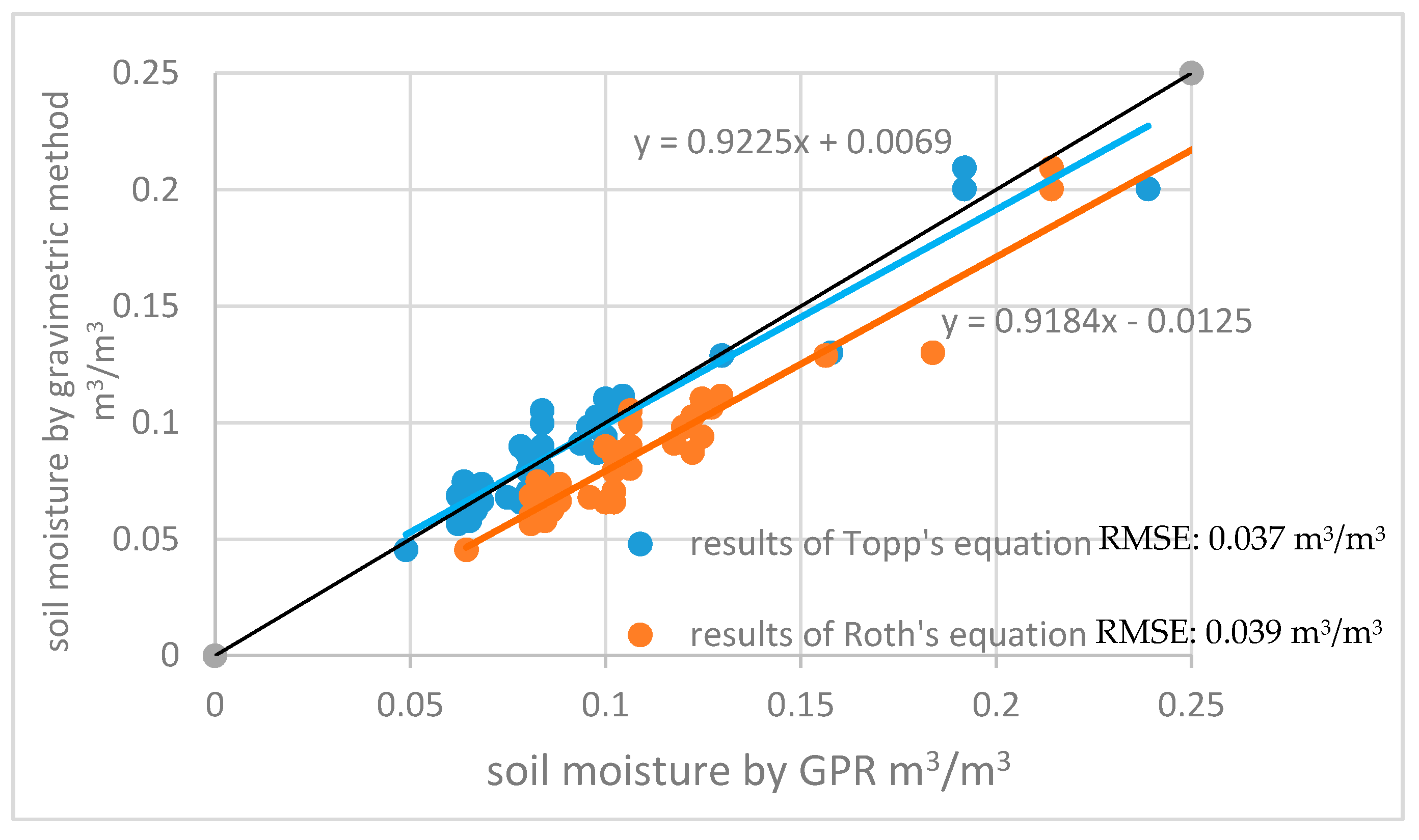
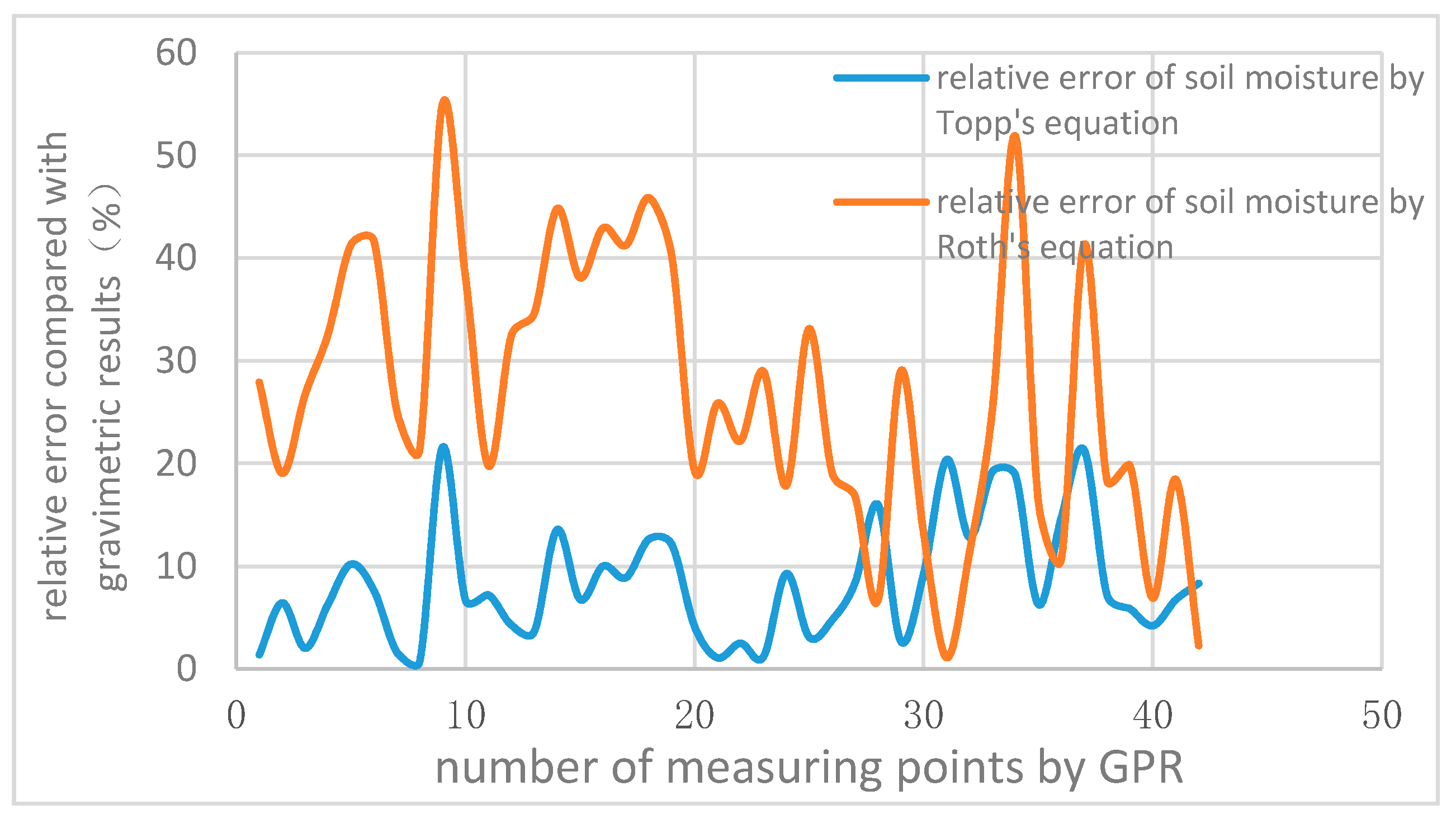
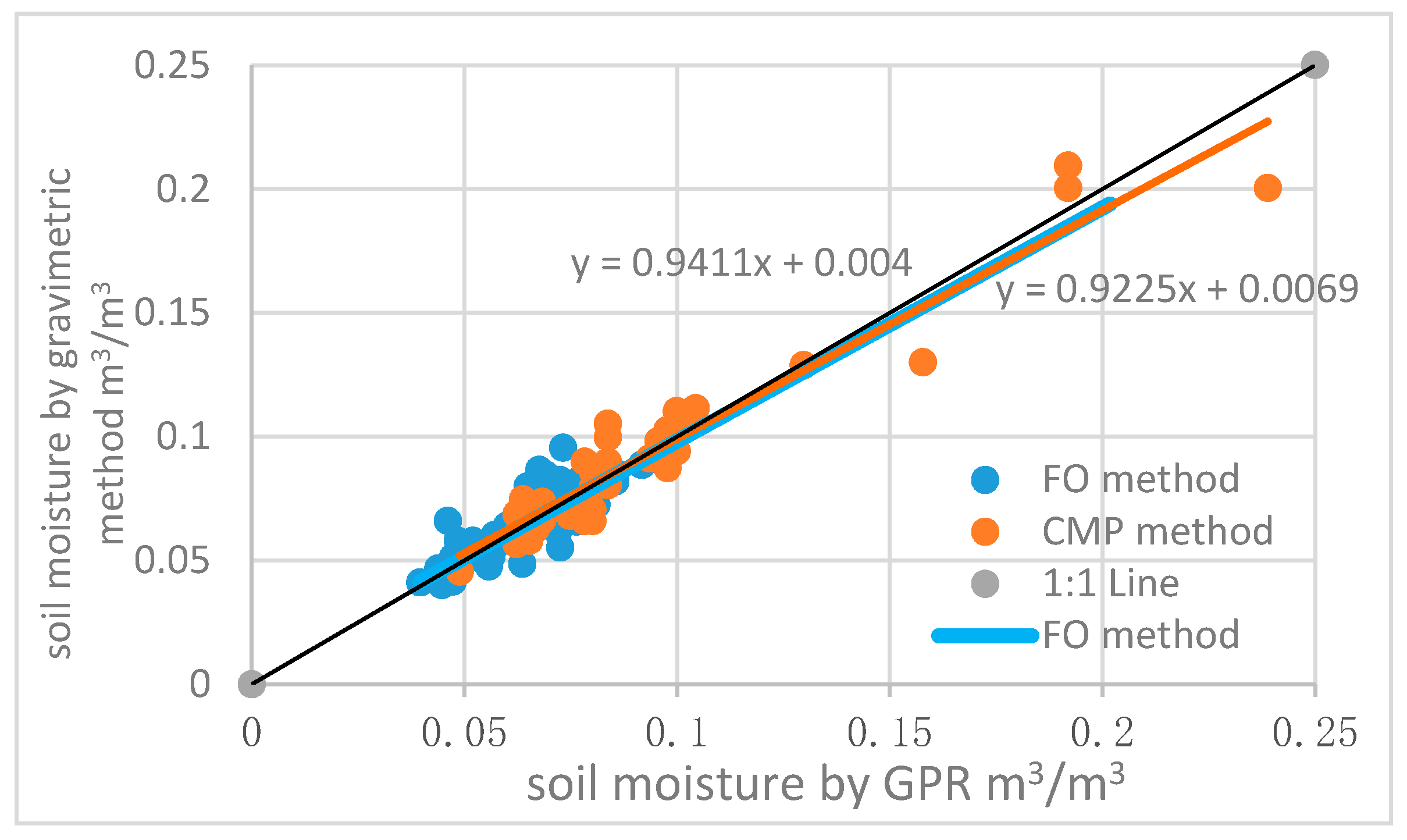
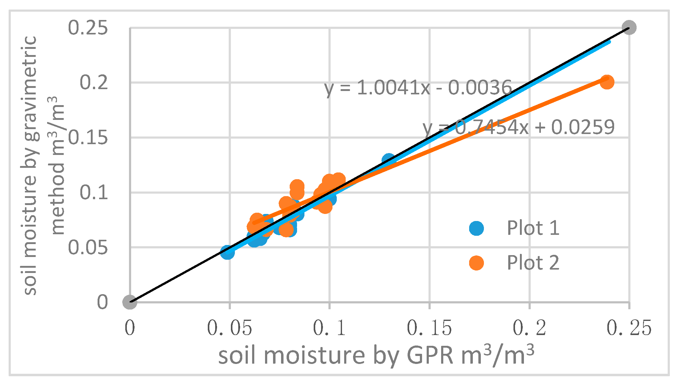
3.1. Inspection of the GPR Measurement Accuracy

Soil moisture measured by gravimetric method was used as the standard value to compare the GPR-derived soil moisture results estimated by Topp’s equation to those by Roth’s equation. The soil moisture estimated by the Topp’s equation was much closer to the gravimetric result, and the soil moisture derived by Roth’s equation was generally higher than the gravimetric data (Figure 4). The relative error and variation of Topp’s equation was significantly lower than those of the Roth’s equation (Figure 5). For desert steppe region, the Topp’s equation is more stable and accurate when calculating the soil moisture measured by GPR. This paper chooses the Topp’s equation to calculate the GPR-derived soil moisture for the following analysis.
For CMP method, the results showed that the average soil moisture at the depth of 0.10 m from ground wave in Plot 1 was 0.075 m3/m3, and that in Plot 2 was 0.094 m3/m3. The soil moisture extracted by ground wave had an RMSE of 0.0101 m3/m3 compared to the gravimetric measurements at the depth of 0.10 m.
Soil moisture calculated by CMP method and FO method was compared with gravimetric measurements at the depth of 0.10 m. The accuracy of FO method and CMP method were similarly high with an RMSE of 0.0068 m3/m3 and 0.0101 m3/m3 (Figure 6), which means the GPR measurement results are reliable in desert steppe.

3.2. Soil Moisture of Different Land Cover Types

In this experiment, the soil moisture of four different land cover types (Figure 7) at different depth obtained by ground wave and reflected wave are shown in Table 1. In the farmland area, the soil natural layered structure was destroyed, and the measured results were consistent with the actual conditions. Because alfalfa and vegetable regions are located in the farmland area with drip irrigation facilities, the soil moisture of alfalfa and vegetable regions were significantly higher than other land cover regions, suggesting that the measurement results were in line with the actual conditions. The change of soil water content in the soil profile of vegetable and alfalfa was larger than that of grassland in the soil profile, and the soil water was accumulated in the soil surface. In addition to the area of farmland, the soil moisture of grassland and its fluctuation at depths from 0 m to 0.40 m between different regions were relatively close, while the soil moisture at depths below 0.40 m in grassland between regions had larger fluctuation than that in surface soil.

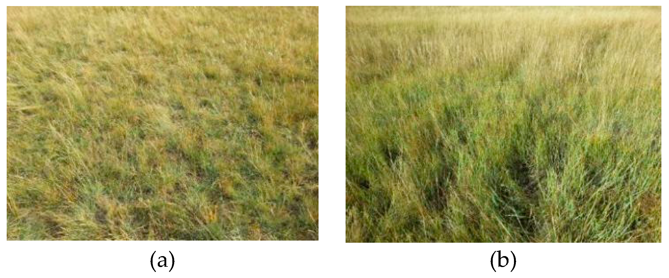
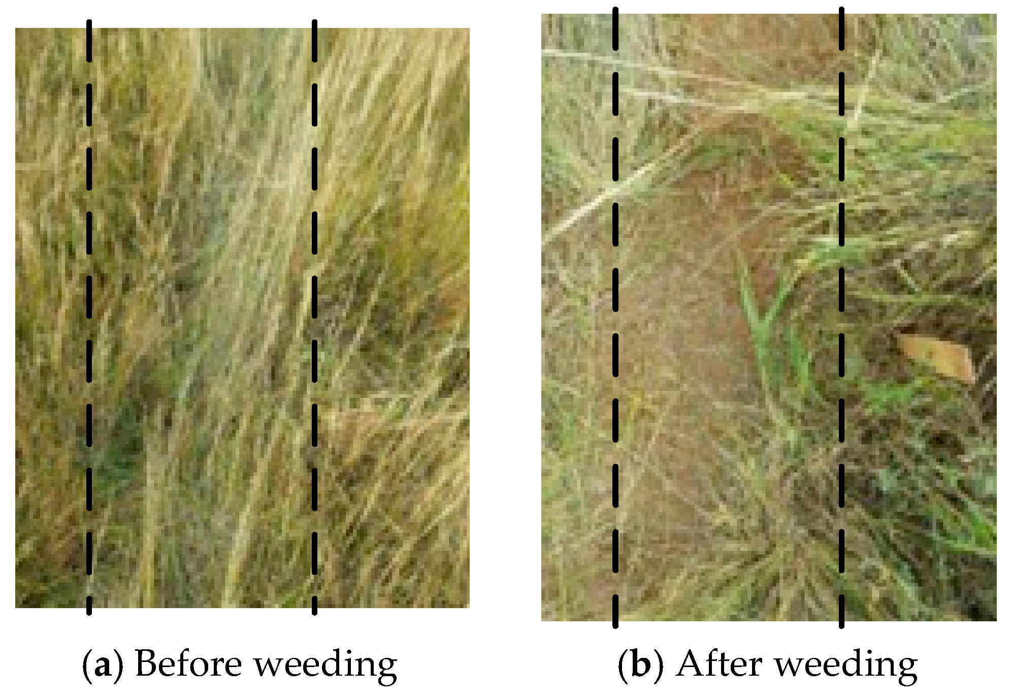
3.3. Effects of Vegetation Coverage on Soil Moisture and Its Measuring Accuracy

Vegetation coverage has a great impact on soil moisture and surface evapotranspiration. Due to the difference in root distribution, the response to this impact is not the same at different depths of the soil profile. The vegetation coverage of two plots had obvious differences, where the average normalized difference vegetation index (NDVI) of Plot 1 and Plot 2 were 0.30 and 0.56. The average surface soil moisture of Plot 1 and Plot 2 at the depth of 0.10 m were 0.0750 m3/m3 and 0.0939 m3/m3 respectively, of which the soil moisture of Plot 2 was significantly higher. However, for deeper soil moisture (about 0.42 m), the average soil moisture in Plot 1 was 0.0975 m3/m3, and higher than that in Plot 2 with 0.0716 m3/m3.
The reason for this phenomenon is that vegetation coverage was obviously different in two plots (Figure 8). The vegetation coverage of Plot 2 was higher than that of Plot 1. The higher vegetation coverage lead to less evaporation of water on the soil surface, so the surface soil moisture of Plot 2 at the depth of 0.10 m is higher. Whereas the vegetation evapotranspiration is derived from the water absorbed by roots from the soil moisture. The vegetation root system of Plot 2 was more developed and dense than that in Plot 1 because of the higher vegetation coverage. The vegetation root in Plot 2 absorbed more water from deep soil because of higher evapotranspiration than that in Plot 1 under the same condition. As a result, the deep soil moisture of Plot 1 was higher.
The comparison of soil moisture measured by ground wave in Plot 1 and Plot 2 (Figure 9) showed that the measurements of Plot 1 were more similar to gravimetric results at the depth of 0.10 m than that of Plot 2, with an RMSE of 0.0059 m3/m3 and 0.0130 m3/m3, respectively. The measuring accuracy of Plot 2 was significantly higher than Plot 1 perhaps because the high vegetation coverage affects the air refraction of the GPR measurements. When the vegetation coverage was high, a large amount of air refraction wave was generated during the process of radar wave propagation, which interfered with the waveform of the ground wave and was reflected wave in the radar profile, affecting the extraction accuracy of wave velocity. At the same time, too much air refraction wave can cause rapid attenuation of radar wave, and hinder the GPR measurement of soil moisture at deep depth. Therefore, the accuracy of GPR measurements can be improved if weeding. For two selected measuring points with dense vegetation in Plot 2 (Figure 10), the relative error of soil moisture compared with gravimetric method decreased from 19.24% and 12.80%, respectively, to 4.22% and 6.74% by weeding. The experimental results further showed that the vegetation coverage to a certain extent affected the accuracy of GPR measurements.

3.4. Effect of Precipitation on GPR Measurements

After raining during 11 June 2016, we applied CMP method to measure soil moisture of two plots. Ground wave velocity was extracted to estimate surface soil moisture from radar profile, obtaining the average soil moisture of 0.1873 m3/m3 and 0.1563 m3/m3. Compared with gravimetric soil moisture at depths of 0.05, 0.10, and 0.15 m, the effective depth of the ground wave by CMP method was 0.05 m. The average relative error of GPR measurement compared with gravimetric soil moisture at the depth of 0.05 m was 9.45%. The depth of soil moisture extracted by ground wave became smaller after raining, that is, the effective depth of ground wave became smaller due to the influence of the precipitation. Because of less rain in the experimentation area for a long time, soil moisture was generally low. Precipitation makes surface soil moisture much higher than that of the lower soil layer, forming high speed propagation layer of radar wave in the soil layer about 0.05 m. The radar wave was spread on the interface formed by the difference of soil moisture, which makes the effective depth of the ground wave smaller.

4. Conclusions

As a nondestructive measuring method, ground penetrating radar (GPR) was used in the fields of soil water monitoring, and soil moisture dynamic. In this paper, GPR was used to measure soil moisture in Inner Mongolia desert steppe. The accuracy of GPR measurement was verified by gravimetric method. The influence of vegetation coverage and precipitation on GPR measurement was analyzed. The research showed that GPR can accurately measure the soil moisture of desert steppe and meet the actual demand of field monitoring.
  • For desert steppe region, the Topp’s equation is more accurate than the Roth’s equation in calculating the soil moisture of GPR data.
  • The soil moisture measurements by GPR were consistent with gravimetric results, with the RMSE of only 0.0101 m3/m3. Compared with the traditional gravimetric method and TDR, GPR can quickly measure the soil moisture at different depths and obtain soil stratification condition without destroying soil layer structure by virtue of the portable and operational characteristics.
  • The vegetation coverage affects the accuracy of GPR measurement and also affects the profile distribution of soil water content. When vegetation coverage is high, the air refraction wave interferes with the ground wave and reflected wave in the radar profile, which can reduce the accuracy of GPR measurement.
  • Under certain conditions, precipitation reduces the effective depth of the ground wave, and further affects the depth of the soil moisture measured by the GPR ground wave.
  • The accuracy comparison of GPR measurement in different soil types, the application of different GPR methods in desert steppe, and the combination of GPR and soil water model are to be further studied.

Acknowledgments

This work was supported by the National Key Research and Development Plan of China (2016YFC0400106-2), by the Natural Science Foundation of China (51609259), and by the Research Program of China Institute of Water Resources and Hydropower Research (JZ0145B472016, JZ0145B862017). We would like to thank the Institute of Water Resources for Pastoral for providing the research field and the field working condition.

Author Contributions

Yizhu Lu and Jingxuan Lu designed the experiments; Yizhu Lu, Wenlong Song, and Jingxuan Lu performed the experiments; Yizhu Lu and Xuefeng Wang processed the GPR data; Yizhu Lu and Yanan Tan participated in the analysis of the data; Yizhu Lu and Wenlong Song wrote the paper.

Conflicts of Interest

The authors declare no conflict of interest.

Abbreviations

TDRTime domain reflector
FDRFrequency domain reflectometer
GPRGround penetrating radar
CRSCosmic-ray sensing probe
FO methodFixed offset method
CMP methodCommon-midpoint method
WARR methodWide angle reflection and refraction method

References

  1. Wang, L.; Qu, J.J. Satellite remote sensing applications for surface soil moisture monitoring: A review. Front. Earth Sci. 2009, 3, 237–247. [Google Scholar] [CrossRef]
  2. Ardekani, M.R.M. Off- and on-ground GPR techniques for field-scale soil moisture mapping. Geoderma 2013, 200–201, 55–66. [Google Scholar] [CrossRef]
  3. Huisman, J.A.; Sperl, C.; Bouten, W.; Verstraten, J.M. Soil water content measurements at different scales: Accuracy of time domain reflectometry and ground-penetrating radar. J. Hydrol. 2001, 254, 48–58. [Google Scholar] [CrossRef]
  4. Galagedara, L.W.; Parkin, G.W.; Redman, J.D.; von Bertoldi, P.; Endres, A.L. Field studies of the GPR ground wave method for estimating soil water content during irrigation and drainage. J. Hydrol. 2005, 245, 182–197. [Google Scholar] [CrossRef]
  5. Hubbard, S.; Grote, K.; Rubin, Y. Mapping the volumetric soil water content of a California vineyard using high-frequency GPR ground wave data. Lead. Edge 2002, 21, 552–559. [Google Scholar] [CrossRef]
  6. Steelman, C.M.; Endres, A.L. Assessing vertical soil moisture dynamics using multi-frequency GPR common-midpoint soundings. J. Hydrol. 2012, 436–437, 51–66. [Google Scholar] [CrossRef]
  7. Ma, Y.; Zhang, Y.; Zubrzycki, S.; Guo, Y.; Farhan, S.B. Hillslope-scale variability in seasonal frost depth and soil water content investigated by GPR on the southern margin of the sporadic permafrost zone on the Tibetan Plateau. Permafr. Periglac. Process. 2015, 26, 321–334. [Google Scholar] [CrossRef]
  8. Grote, K.; Hubbard, S.; Rubin, Y. Field-scale estimation of volumetric water content using ground-penetrating radar ground wave techniques. Water Resour. Res. 2003, 39, 1321–1335. [Google Scholar] [CrossRef]
  9. Wijewardana, Y.G.N.S.; Galagedara, L.W. Estimation of spatio-temporal variability of soil water content in agricultural fields with ground penetrating radar. J. Hydrol. 2010, 391, 24–33. [Google Scholar] [CrossRef]
  10. Pan, X.; Zhang, J.; Huang, P.; Roth, K. Estimating field-scale soil water dynamics at a heterogeneous site using multi-channel GPR. Hydrol. Earth Syst. Sci. 2012, 16, 4361–4372. [Google Scholar] [CrossRef] [Green Version]
  11. Overmeeren, R.A.V.; Sariowan, S.V.; Gehrels, J.C. Ground penetrating radar for determining volumetric soil water content: Results of comparative measurements at two test sites. J. Hydrol. 1997, 197, 316–338. [Google Scholar] [CrossRef]
  12. Steelman, C.M.; Endres, A.L.; Jones, J.P. High-resolution ground-penetrating radar monitoring of soil moisture dynamics: Field result, interpretation, and comparison with unsaturated flow model. Water Resour. Res. 2012, 48, 184–189. [Google Scholar] [CrossRef]
  13. Huisman, J.A.; Snepvangers, J.J.J.C.; Bouten, W.; Heuvelink, G.B.M. Mapping spatial variation in surface soil water content: Comparison of ground-penetrating radar and time domain reflectometry. J. Hydrol. 2002, 269, 194–207. [Google Scholar] [CrossRef]
  14. Weihermüller, L.; Huisman, J.A.; Lambot, S.; Herbst, M.; Vereecken, H. Mapping the spatial variation of soil water content at the field scale with different ground penetrating radar techniques. J. Hydrol. 2007, 340, 205–216. [Google Scholar] [CrossRef] [Green Version]
  15. Lunt, I.A.; Hubbard, S.S.; Rubin, Y. Soil moisture content estimation using ground-penetrating radar reflection data. J. Hydrol. 2005, 307, 254–269. [Google Scholar] [CrossRef]
  16. Stoffregen, H.; Yaramanci, U.; Zenker, T.; Wessolek, G. Accuracy of soil water content measurements using ground penetrating radar: Comparison of ground penetrating radar and lysimeter data. J. Hydrol. 2002, 267, 201–206. [Google Scholar] [CrossRef]
  17. Wang, Q.; Zhou, K.; Sun, L.; Qin, Y.; Li, G. A study of fast estimating soil water content by ground penetrating radar. J. Nat. Resour. 2013, 28, 881–888. (In Chinese) [Google Scholar]
  18. Qin, Y.; Chen, X.; Zhou, K.; Sun, L.; Zhang, J. Using GPR to sound the spatial and temporal distributions of dune surface soil water contents before and after snowmelt in the early spring. J. Glaciol. Geocryol. 2012, 34, 690–697. (In Chinese) [Google Scholar]
  19. Guo, X.; Wang, M.; Zhang, G.; Hou, L.; Sun, P.; Meng, Q. Nondestructive and quick in-situ testing of unsaturated sandy soil water content using ground penetrating radar refection method. Period. Ocean Univ. China 2010, 40, 141–145. (In Chinese) [Google Scholar]
  20. Ma, F.; Lei, S.; Yang, S.; Zhen, F.; Wang, Y. Study on the relationship between soil water content and ground penetrating radar signal attributes. Chin. J. Soil Sci. 2014, 45, 809–815. (In Chinese) [Google Scholar]
  21. Li, H.; Zhong, R. Numerical study on the relationship between amplitudes of ground penetrating radar wave and water content in soil. J. Appl. Sci. 2015, 33, 41–49. (In Chinese) [Google Scholar]
  22. Mangel, A.R.; Moysey, S.M.J.; Ryan, J.C.; Tarbutton, J.A. Multi-offset ground-penetrating radar imaging of a lab-scale infiltration test. Hydrol. Earth Syst. Sci. 2011, 16, 4009–4022. [Google Scholar] [CrossRef] [Green Version]
  23. Moysey, S. Hydrologic trajectories in transient ground-penetrating radar reflection data. Geophysics 2010, 75, 211–219. [Google Scholar] [CrossRef]
  24. Cui, F.; Wu, Z.; Wang, L.; Wu, Y. Application of the ground penetrating radar ARMA power spectrum estimation method to detect moisture content and compactness values in sandy loam. J. Appl. Geophys. 2015, 120, 26–35. [Google Scholar] [CrossRef]
  25. Tran, A.P.; André, F.; Lambot, S. Validation of near-field ground-penetrating radar modeling using full-wave inversion for soil moisture estimation. IEEE Trans. Geosci. Remote Sens. 2014, 52, 5483–5497. [Google Scholar] [CrossRef]
  26. Davis, J.L.; Annan, A.P. Ground penetrating radar for high resolution mapping of soil and rock stratigraphy. Geophys. Prospect. 1989, 37, 531–551. [Google Scholar] [CrossRef]
  27. Topp, G.C.; Davis, J.L.; Annan, A.P. Electromagnetic determination of soil water content: Measurements in coaxial transmission lines. Water Resour. Res. 1980, 16, 574–582. [Google Scholar] [CrossRef]
  28. Roth, C.H.; Malicki, M.A.; Plagge, R. Empirical evaluation of the relationship between soil dielectric constant and volumetric water content as the basis for calibrating soil moisture measurements by TDR. Soil Sci. 1992, 43, 1–13. [Google Scholar] [CrossRef]
  29. Sperl, C. Erfassung der Raum-Zeitlichen Variation des Boden-Wassergehaltes in Einem Agrarokosystem mit dem Ground-Penetrating Radar. Ph.D. Thesis, Technische Universitat, München, Germany, 1999; p. 182. [Google Scholar]
  30. Huisman, J.A.; Hubbard, S.S.; Redman, J.D.; Annan, A.P. Measuring soil water content with ground penetrating radar: A review. Vadose Zone J. 2003, 2, 476–491. [Google Scholar] [CrossRef]
  31. Tosti, F.; Slob, E. Determination by using GPR of the volumetric water content in strucures substructures foundations and soil. In Civil. Engineering Applications of Ground Penetrating Radar; Springer International Publishing: Cham, Switzerland, 2015. [Google Scholar]
  32. Lu, Y.; Song, W.; Lu, J.; Su, Z.; Liu, H.; Tan, Y.; Han, J. Soil water measurement by ground penetrating radar and its scale features. South.-to-North. Water Transf. Water Sci. Technol. 2017, 15, 37–44. (In Chinese) [Google Scholar]
Figure 1. Distribution of land cover types in study area.
Water 09 00521 g001
Figure 2. Schematic diagram of CMP method (a) and FO method (b).
Water 09 00521 g002
Figure 3. Disposition pattern of measuring points and lines in plots.
Water 09 00521 g003
Figure 4. Soil moisture calculated by Topp’s equation and Roth’s equation in comparison with gravimetric method.
Water 09 00521 g004
Figure 5. Comparison between relative error of soil moisture calculated by Topp’s equation and that by Roth’s equation.
Water 09 00521 g005
Figure 6. Soil moisture calculated by CMP method and FO method in comparison with gravimetric method.
Water 09 00521 g006
Figure 7. Vegetables (a), alfalfa (b), natural grassland (c), washland (d).
Water 09 00521 g007
Figure 8. Vegetation condition in Plot 1 (a) and Plot 2 (b).
Water 09 00521 g008
Figure 9. Comparison of the soil moisture measured by GPR and gravimetric method in Plot 1 and Plot 2.
Water 09 00521 g009
Figure 10. Contrast diagram before (a) and after (b) weeding (marking area by dotted line is weed control part).
Water 09 00521 g010
Table 1. Soil moisture of four different land cover types and two plots obtained by ground wave and reflected wave.
Land Cover TypeSoil Moisture by Ground Wave (m3/m3)Effective Depth (m)Soil Moisture above the First Reflected Layer (m3/m3)Effective Depth (m)Soil Moisture above the Second Reflected Layer (m3/m3)Effective Depth (m)
Alfalfa0.19190.100.09780.63
Vegetables0.15780.100.19610.250.16120.66
Washland0.08010.100.06220.400.12430.71
Natural Grassland0.08190.100.06520.360.10210.75
Plot 10.07500.100.09750.41
Plot 20.09390.100.07160.43

