A Commune-Level Groundwater Potential Map for the Republic of Mali


Abstract
:1. Introduction
2. Materials and Methods
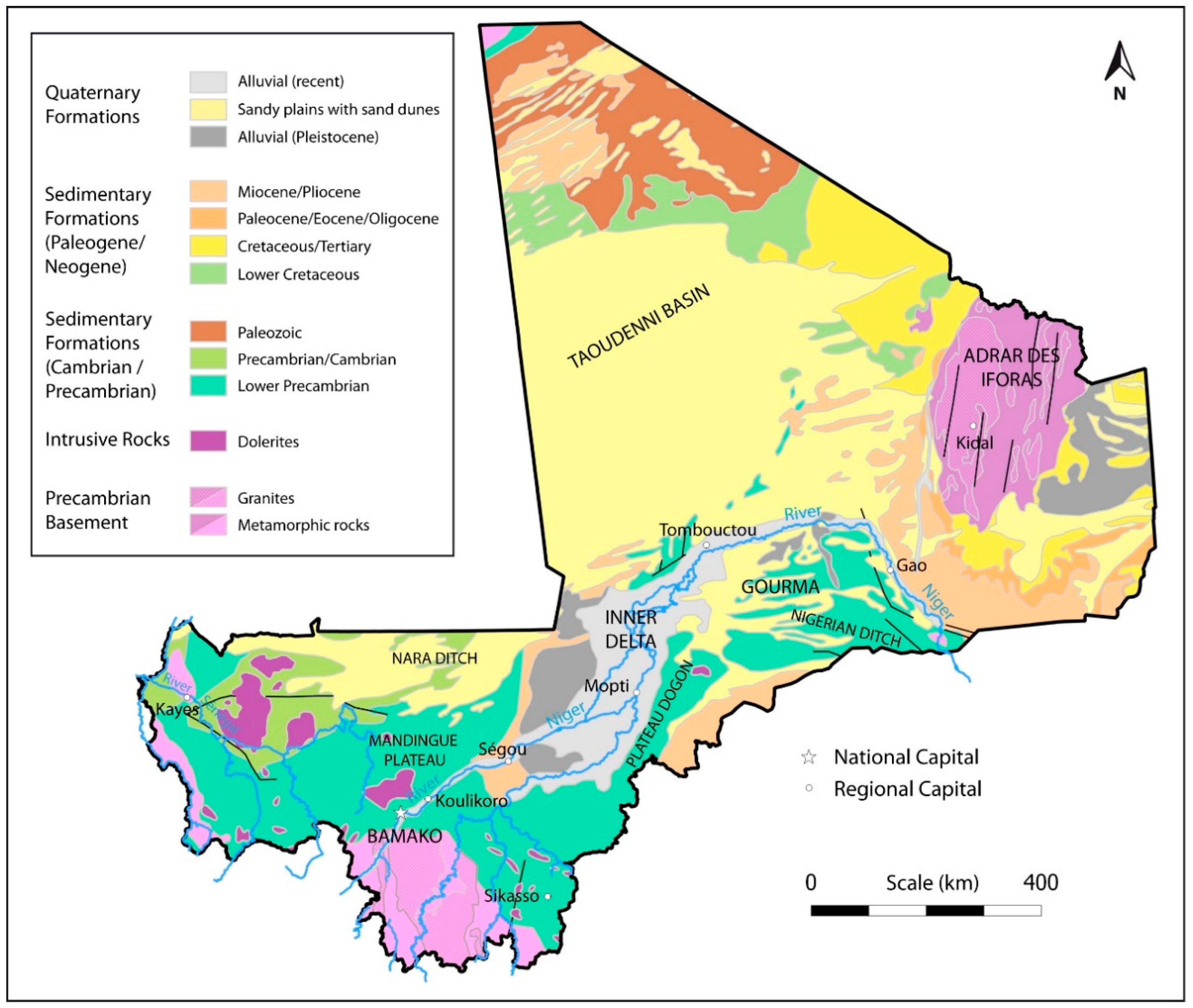
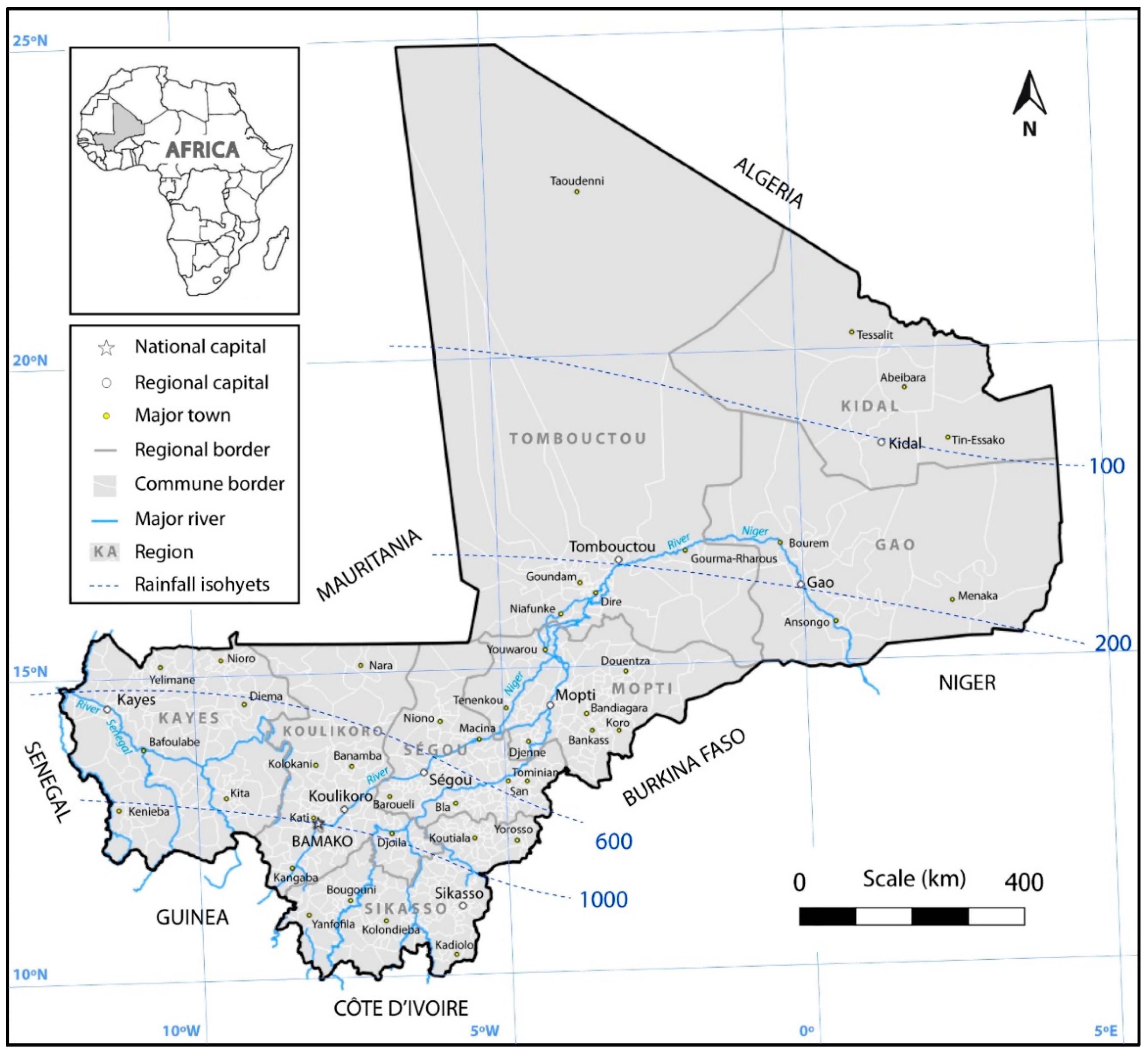
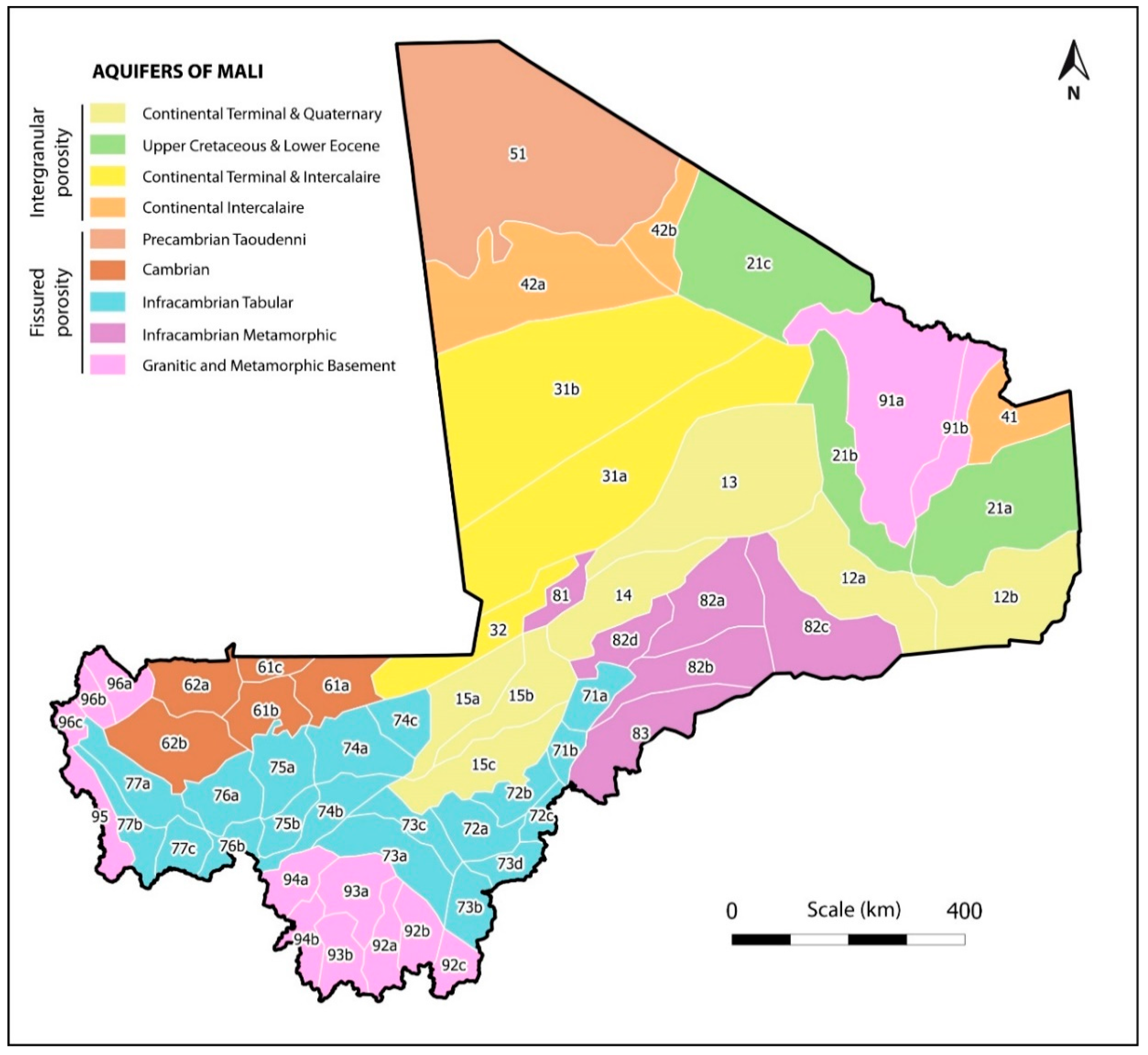
2.1. Study Area
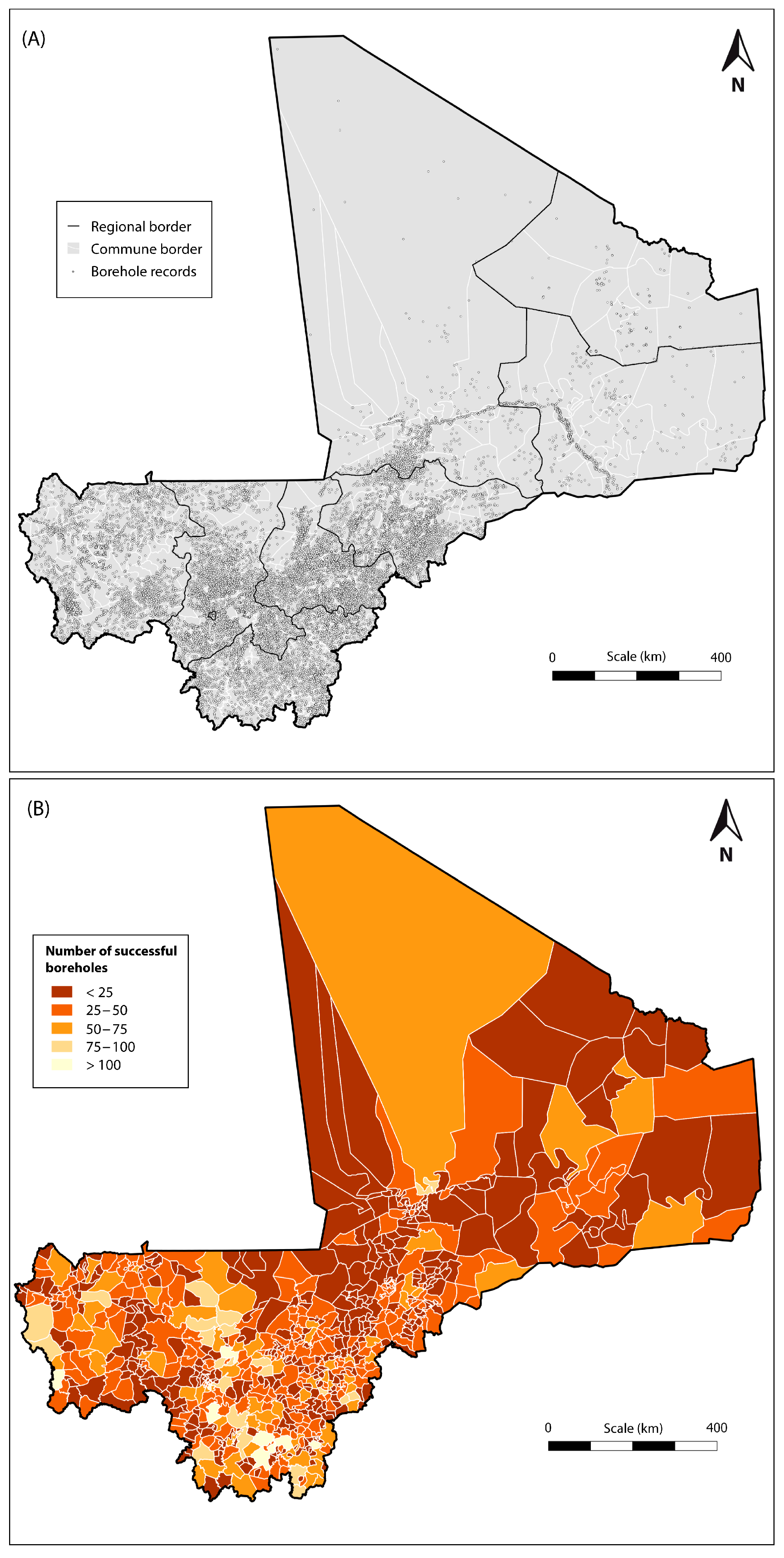
2.2. Borehole Database
2.3. GIS Analysis
3. Results and Discussion
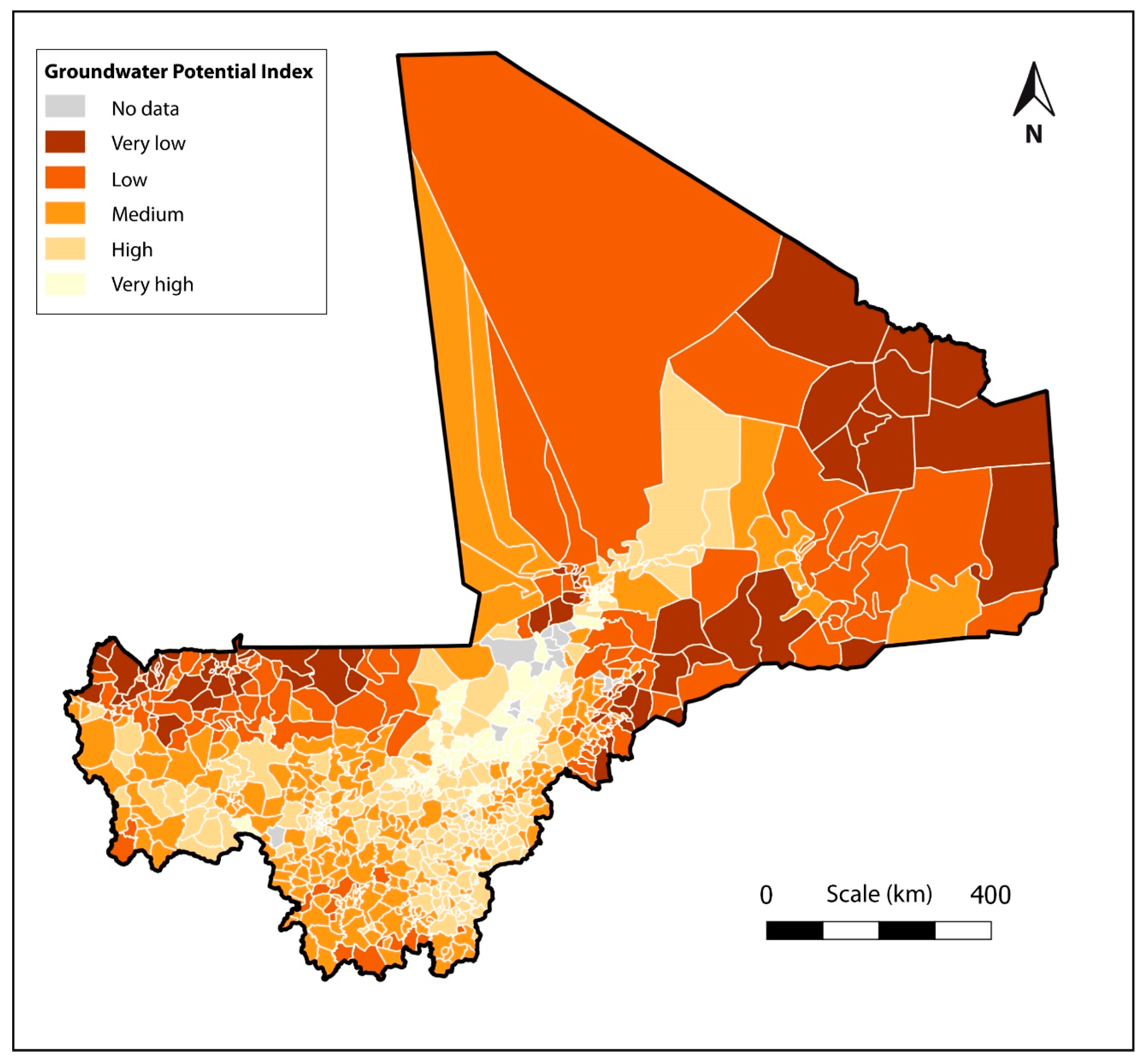
3.1. National Classification of Groundwater Potential
3.2. Methodological Aspects and Limitations
4. Conclusions
Acknowledgments
Author Contributions
Conflicts of Interest
References
- Foster, S.; Garduño, H. Groundwater-resource governance: Are governments and stakeholders responding to the challenge? Hydrogeol. J. 2012, 21, 317–320. [Google Scholar] [CrossRef]
- Adelana, S.M.A.; MacDonald, A.M. Groundwater research issues in Africa. In Applied Groundwater Studies in Africa; IAH Selected Papers on Hydrogeology; CRC Press/Balkema: Leiden, The Netherlands, 2008. [Google Scholar]
- Direction Nationale de l’Hydraulique (DNH). Données Hydrogeologiques et des Forages; Direction Nationale de l’Hydraulique; Ministère de l’Environnement, de l’Eau et de l’Assainissement: Bamako, Mali, 2010. (In French)
- Barry, B.; Obuobie, E. Mali. In Groundwater Availability and Use in Sub-Saharan Africa: A Review of 15 Countries; Pavelic, P., Giordano, M., Keraita, B., Ramesh, V., Rao, T., Eds.; International Water Management Institute (IWMI): Colombo, Sri Lanka, 2012; p. 274. [Google Scholar] [CrossRef]
- USGS (US Geological Survey). A Climate Trend Analysis of Mali. Famine Early Warning Systems Network—Informing Climate Change Adaptation Series; Fact Sheet 2012-3105; US Geological Survey: Reston, VA, USA, 2012; p. 4.
- MacDonald, A.M.; Bonsor, H.C.; Ó Dochartaigh, B.É.; Taylor, R.G. Quantitative maps of groundwater resources in Africa. Environ. Res. Lett. 2012, 7, 024009. [Google Scholar] [CrossRef]
- Gumma, M.K.; Pavelic, P. Mapping of groundwater potential zones across Ghana using remote sensing, geographic information systems, and spatial modeling. Environ. Monit. Assess. 2013, 185, 3561–3579. [Google Scholar] [CrossRef] [PubMed]
- Sternberg, T.; Paillou, P. Mapping potential shallow groundwater in the Gobi Desert using remote sensing: Lake Ulaan Nuur. J. Arid Environ. 2015, 118, 21–27. [Google Scholar] [CrossRef]
- Martínez-Santos, P.; Martín-Loeches, M.; Solera, D.; Cano, B.; Díaz-Alcaide, S. Mapping the Viability, Time, and Cost of Manual Borehole Drilling in Developing Regions. Water 2017, 9, 262. [Google Scholar] [CrossRef]
- Alfonso, M.J.; Freitas, L.; Pereira, A.; Neves, L.; Guimaraes, L.; Guilhermino, L.; Mayer, B.; Rocha, F.; Marques, J.M.; Chamine, H.I. Environmental Groundwater Vulnerability Assessment in Urban Water Mines (Porto, NW Portugal). Water 2016, 8, 499. [Google Scholar] [CrossRef]
- Hernández-Espriú, A.; Reyna-Gutiérrez, J.A.; Sánchez-León, E.; Cabral-Cano, E.; Carrera-Hernández, J.; Martínez-Santos, P.; Falorni, G.; Colombo, D. DRASTIC-Sg Model, a new extension to the DRASTIC approach for mapping groundwater vulnerability in aquifers subject to differential land subsidence. Application to Mexico City. Hydrogeol. J. 2014, 22, 1469–1485. [Google Scholar] [CrossRef]
- Oke, S.A.; Fourie, D. Guidelines to groundwater vulnerability mapping for Sub-Saharan Africa. Groundw. Sustain. Dev. 2017, 5, 168–177. [Google Scholar] [CrossRef]
- Wada, Y.; van Beek, L.P.H.; van Kempen, C.M.; Reckman, J.W.T.M.; Vasak, S.; Bierkens, M.F.P. Global depletion of groundwater resources. Geophys. Res. Lett. 2010, 37, L20402. [Google Scholar] [CrossRef]
- Konikow, L.F. Groundwater Depletion in the United States (1900−2008): U.S. Geological Survey Scientific Investigations Report 2013–5079. 2013. Available online: http://pubs.usgs.gov/sir/2013/5079 (accessed on 26 July 2017).
- Bera, K.; Bandyopadhyay, J. Ground Water Potential Mapping in Dulung Watershed using Remote Sensing & GIS techniques, West Bengal, India. Int. J. Sci. Res. Publ. 2012, 2, 1–7. [Google Scholar]
- Ganapuram, S.; Vijaya Kumar, G.T.; Murali Krishna, I.V.; Kahya, E.; Cüneyd Demirel, M. Mapping of groundwater potential zones in the Musi basin using remote sensing data and GIS. Adv. Eng. Softw. 2009, 40, 506–518. [Google Scholar] [CrossRef]
- Rahmati, O.; Samani, A.N.; Mahdavi, M.; Pourghasemi, H.R.; Zeinivand, H. Groundwater potential mapping at Kurdistan region of Iran using analytic hierarchy process and GIS. Arab. J. Geosci. 2015, 8, 7059–7071. [Google Scholar] [CrossRef]
- Yeh, H.F.; Cheng, Y.S.; Lin, H.I.; Lee, C.H. Mapping groundwater recharge potential zone using a GIS approach in Hualian River, Taiwan. Sustain. Environ. Res. 2016, 26, 33–43. [Google Scholar] [CrossRef]
- Diallo, M.M.A. Evolution du Climat. Direction Nationale de la Météorologie du Mali. 2011. Available online: http://www.cifal-ouaga.org/new11/mali.pdf (accessed on 21 July 2017).
- Kusnir, I. Gold in Mali. Acta Montan. Slovaca Rocnik 1999, 4, 311–318. [Google Scholar]
- United Nations. Mali. In Ground Water in North and West Africa; Natural Resources/Water Series No. 18; United Nations: New York, NY, USA, 1988; pp. 247–264. [Google Scholar]
- Smedley, P. Groundwater Quality: Mali. British Geological Survey and Water Aid. 2002, p. 5. Available online: http://nora.nerc.ac.uk/516317/ (accessed on 21 July 2017).
- Saad, K. Étude Hydrogéologique de l’Est du Mali; UNESCO/Mali; Ref. 1856/BMS.RD/SCF; UNESCO: Paris, France, 1970. (In French) [Google Scholar]
- Saad, K. Étude hydrogéologique du sud du Mali (Niger Supérieur et Bani); UNESCO/Mali; Ref. 2258/RMS.RS/SCE; UNESCO: Paris, France, 1970. (In French) [Google Scholar]
- DCTD. Synthese Hydrogeologique du Mali; Technical Report; Département de la Coopération Technique pour le Développement, Ministère de l’Industrie de l’Hydraulique et de l’Energie and Programme des Nations Unies pour le Developpment: Bamako, Mali, 1990. (In French)
- Traore, A.Z.; Bokar, H.; Sidibe, A.; Upton, K.; Ó Dochartaigh, B.É. Africa Groundwater Atlas: Hydrogeology of Mali. British Geological Survey. 2016. Available online: http://earthwise.bgs.ac.uk/index.php/Hydrogeology_of_Mali (accessed on 21 July 2017).
- Traore, A.Z. Géologie et Hydrogéologie des Plateaux Mandingues, Mali (Région de Koula Nossombougou). Ph.D. Thesis, Université Scientifique et Médicale de Grénoble, Grenoble, France, 1985. (In French). [Google Scholar]
- Henry, C.M.; Allen, D.M.; Huang, J. Groundwater storage variability and annual recharge using well-hydrograph and GRACE satellite data. Hydrogeol. J. 2011, 19, 741–755. [Google Scholar] [CrossRef]
- Rasse, M. Carte Geologique du Mali. Atlas Mali Jeune Afrique. 2010. Available online: https://www.researchgate.net/publication/258555891_Carte_Geologique_du_Mali (accessed on 25 October 2017).
- Traore, D.; Hui, Q. The Effects of Polluted River Water to the Riverside Groundwater, Case in Niger River in Koulikoro. Environ. Nat. Res. Res. 2014, 4, 238–244. [Google Scholar] [CrossRef]
- Jenks, G.F. The Data Model Concept in Statistical Mapping. Int. Yearb. Cartogr. 1967, 7, 186–190. [Google Scholar]


| Aquifer Type | Groundwater Unit | Lithology | Area (km2) | Area (% Mali) | Code/Sector |
|---|---|---|---|---|---|
| Intergranular | Continental Terminal and Quaternary | Clay, sandy clay, sand, laterites | 202,830 | 16 | 12 Fossé de Gao 13 Azaouad Sud 14 Gourma Nord Ouest 15 Delta Intérieur |
| Upper Cretaceous and Lower Eocene | Limestone, marl | 138,910 | 11 | 21 Bordure Adrar | |
| Continental Terminal and Continental Intercalaire | Sand, sandy clay, clay | 208,870 | 17 | 31 Azaouad Nord 32 Fossé de Nara | |
| Continental Intercalaire | Sand, sandstone, conglomerate | 82,320 | 7 | 41 Tamesna 42 Khenachich | |
| Fissured | Paleozoic Taoudenni | Limestone, sandstone | 112,700 | 9 | 51 Primaire Taoudenni |
| Cambrian | Schist, shale, limestone, sandstone | 66,060 | 5 | 61 Ouagadou 62 Kaarta | |
| Infracambrian Tabular | Sandstone, schist | 174,810 | 14 | 71 Plateau Dogon 72 San-Koutiala 73 Bani Moyen 74 Est Plat. Mandingues 75 Baoulé 76 Bakoye 77 Bafing | |
| Infracambrian Metamorphic | Schist, limestone, quartzite | 97,420 | 8 | 81 Nord Delta 82 Gourma 83 Gondo | |
| Basement (granitic and metamorphic) | Laterite, clay, sand, gravel | 156,080 | 13 | 91 Adrar des Iforas 92 Bagoe 93 Baoulé 94 Sankarani 95 Kéniéba 96 Kayes |
| Region | Surface (1000 km2) | Communes | Population (Thousands) | Boreholes (Successful) | Boreholes (Unsuccessful) | Borehole Success (%) | Successful Boreholes per km2 | Successful Boreholes per 1000 People |
|---|---|---|---|---|---|---|---|---|
| Bamako | 0.25 | 6 | 2352 | 304 | 48 | 86 | 1206 | 0.1 |
| Gao | 89.53 | 24 | 701 | 653 | 136 | 83 | 7 | 0.9 |
| Kayes | 119.74 | 129 | 2590 | 3762 | 1968 | 66 | 31 | 1.5 |
| Kidal | 151.43 | 11 | 81 | 181 | 226 | 44 | 1 | 2.2 |
| Koulikoro | 95.85 | 108 | 3147 | 3560 | 1581 | 69 | 37 | 1.1 |
| Mopti | 79.02 | 108 | 2645 | 2004 | 527 | 79 | 25 | 0.8 |
| Segou | 64.82 | 118 | 3038 | 3384 | 574 | 85 | 52 | 1.1 |
| Sikasso | 70.28 | 147 | 3434 | 4985 | 1041 | 83 | 71 | 1.5 |
| Tombouctou | 496.61 | 52 | 877 | 970 | 136 | 88 | 2 | 1.1 |
| Total/Avg | 703 | 18,865 | 19,803 | 6237 | 76 | 17 | 1.0 |
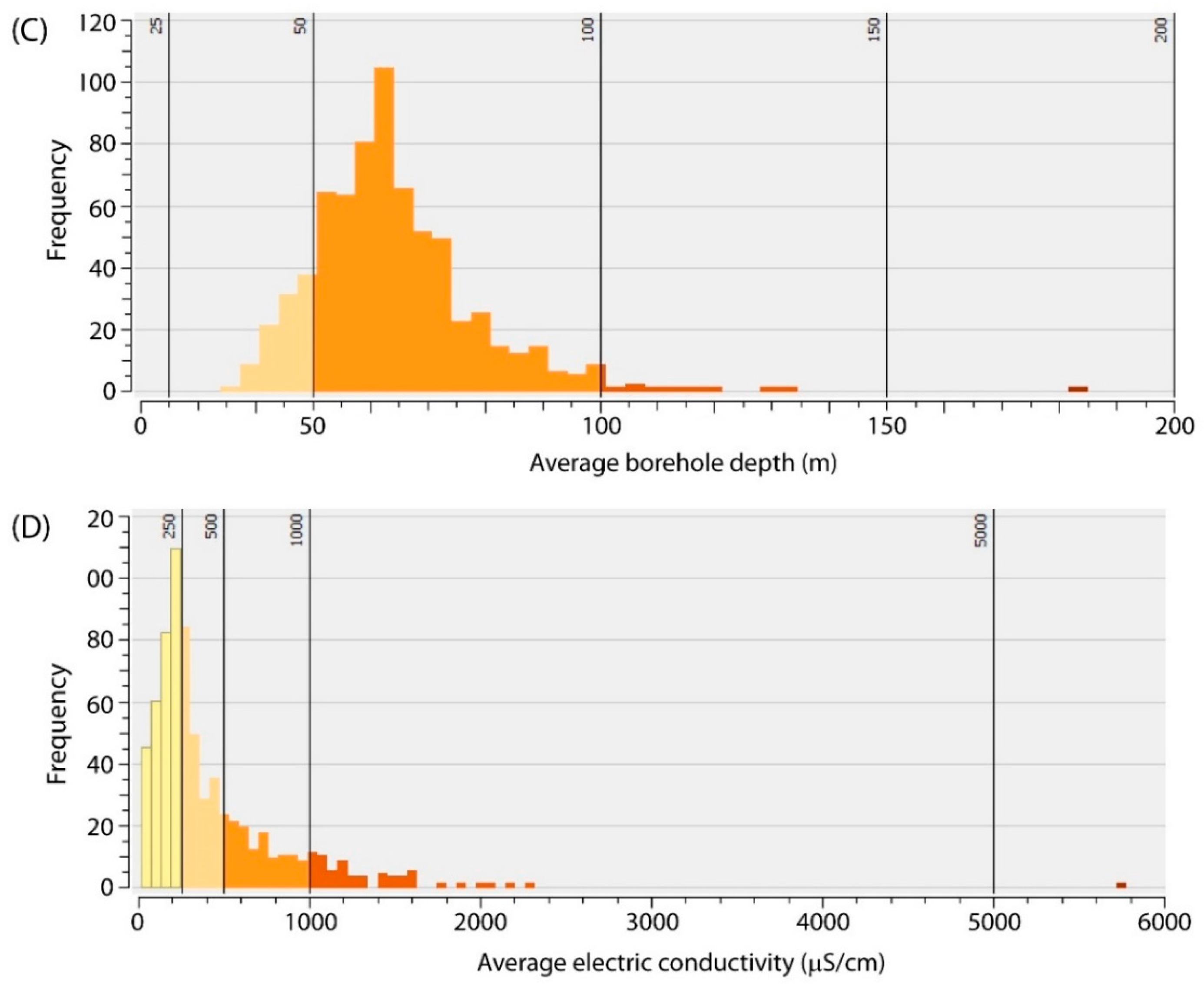
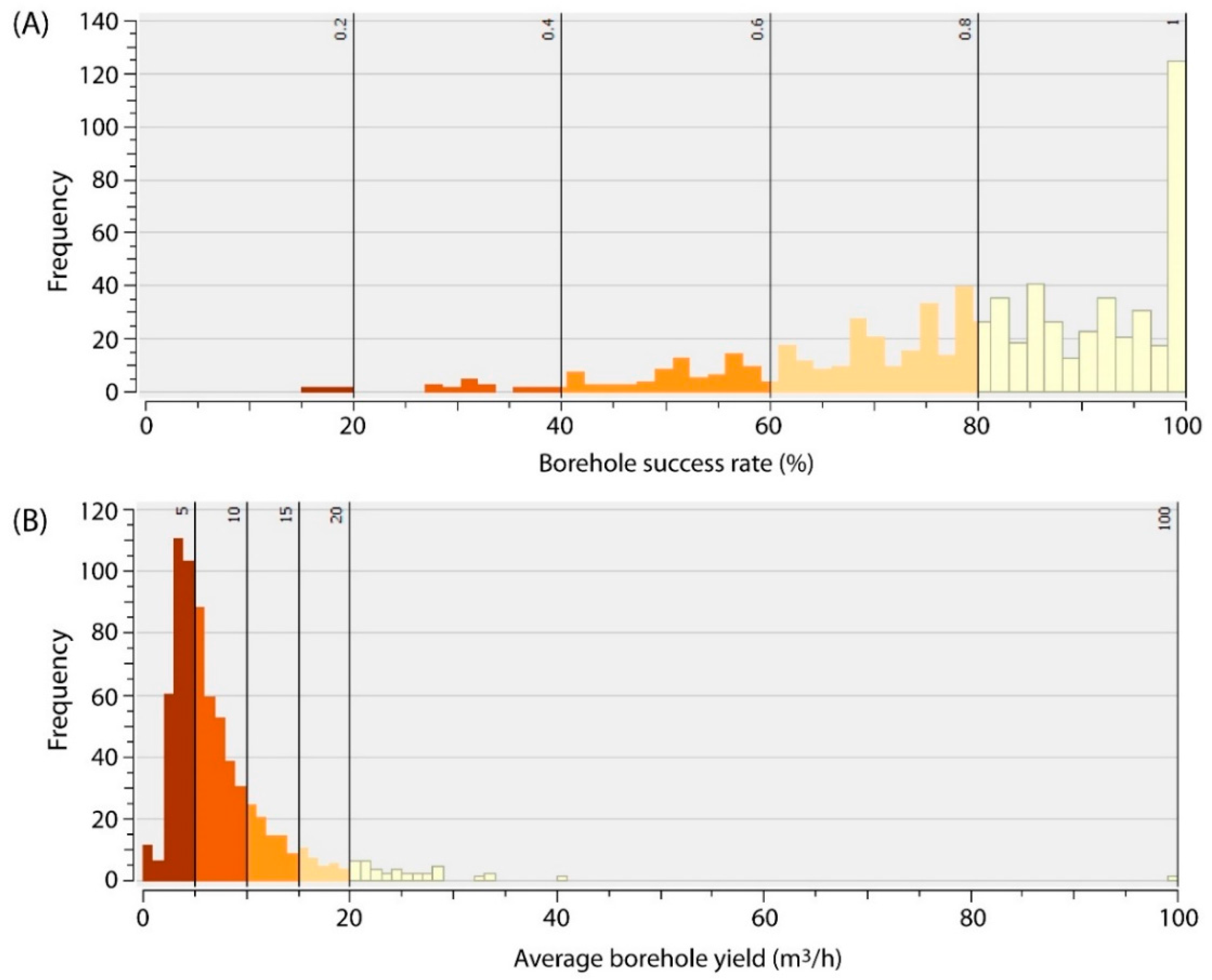
| Item | Borehole Success Rate (%) | Borehole Yield (m3/h) | Electrical Conductivity (μS/cm) | Drilling Depth (m) | Annual Recharge (mm) | Aquifer Thickness (m) | Groundwater Potential |
|---|---|---|---|---|---|---|---|
| Very High | >80 | >20 | <250 | <25 | >150 | >125 | 5 |
| High | 60–80 | 15–20 | 250–500 | 25–50 | 100–150 | 100–125 | 4 |
| Medium | 40–60 | 10–15 | 500–1000 | 50–100 | 50–100 | 75–100 | 3 |
| Low | 20–40 | 5–10 | 1000–5000 | 100–150 | 25–50 | 50–75 | 2 |
| Very Low | <20 | <5 | >5000 | >150 | <25 | <50 | 1 |
| Maximum | 1.00 | 100.0 | 5779 | 185 | 185 | 1000 | - |
| Minimum | 0.15 | 0.9 | 15 | 34 | 0 | 5 | - |
| Arithm. Mean | 0.81 | 8 | 416 | 64 | 60 | 70 | - |
| Standard Deviation | 0.17 | 7 | 417 | 14 | 35 | 37 | - |
© 2017 by the authors. Licensee MDPI, Basel, Switzerland. This article is an open access article distributed under the terms and conditions of the Creative Commons Attribution (CC BY) license (http://creativecommons.org/licenses/by/4.0/).
Share and Cite
Díaz-Alcaide, S.; Martínez-Santos, P.; Villarroya, F. A Commune-Level Groundwater Potential Map for the Republic of Mali. Water 2017, 9, 839. https://doi.org/10.3390/w9110839
Díaz-Alcaide S, Martínez-Santos P, Villarroya F. A Commune-Level Groundwater Potential Map for the Republic of Mali. Water. 2017; 9(11):839. https://doi.org/10.3390/w9110839
Chicago/Turabian StyleDíaz-Alcaide, Silvia, Pedro Martínez-Santos, and Fermín Villarroya. 2017. "A Commune-Level Groundwater Potential Map for the Republic of Mali" Water 9, no. 11: 839. https://doi.org/10.3390/w9110839
APA StyleDíaz-Alcaide, S., Martínez-Santos, P., & Villarroya, F. (2017). A Commune-Level Groundwater Potential Map for the Republic of Mali. Water, 9(11), 839. https://doi.org/10.3390/w9110839