Spatial Downscaling of Suomi NPP–VIIRS Image for Lake Mapping †


Abstract
:
1. Introduction
2. Materials and Methods
2.1. Study Areas and Materials
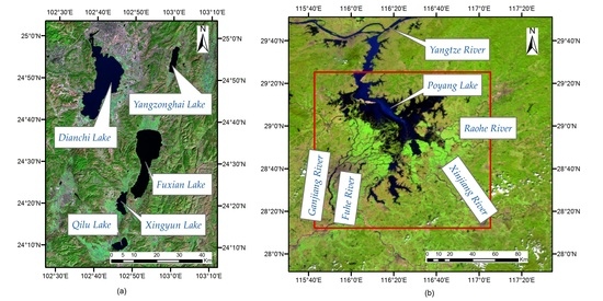
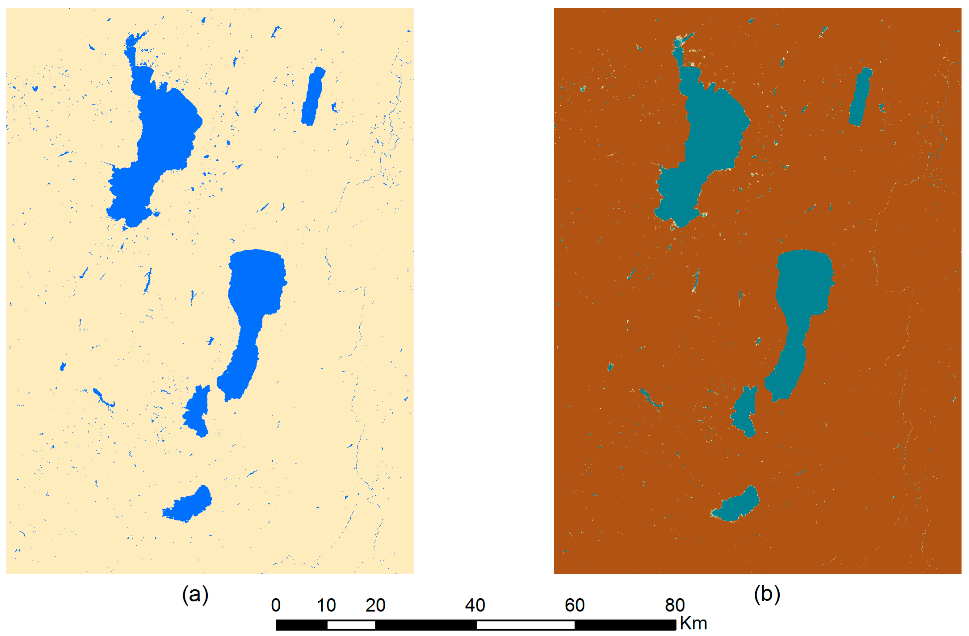
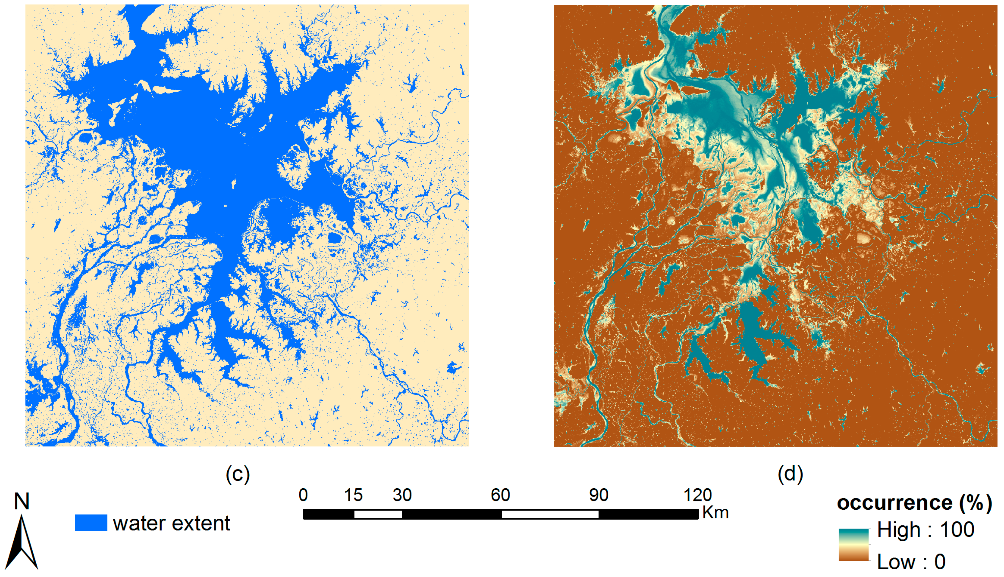
2.1.1. Study Areas
2.1.2. Materials
2.2. Methods
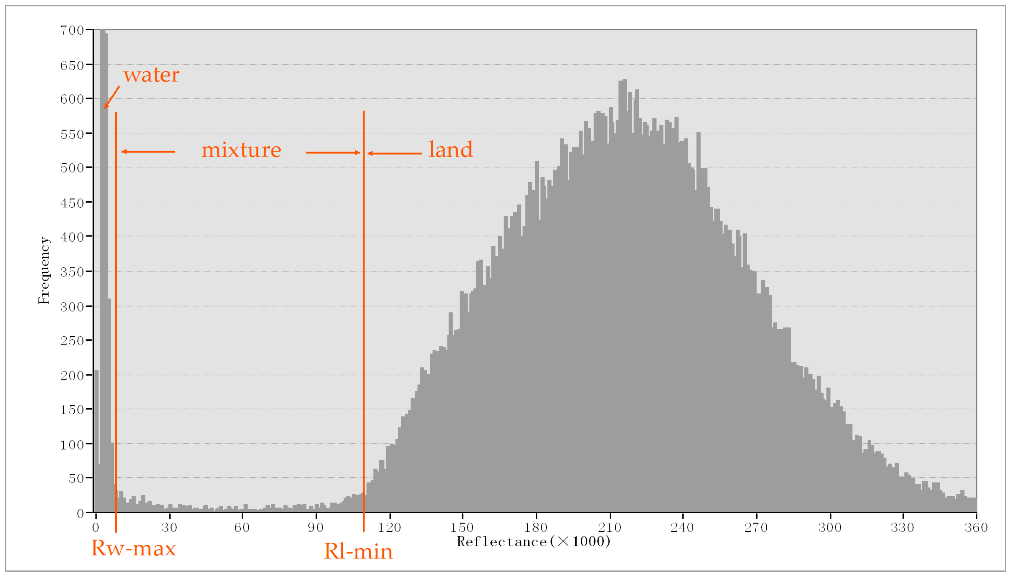
2.2.1. Water Fraction Retrieval
2.2.2. Subpixel Mapping
2.2.3. Accuracy Assessment
3. Results and Discussion
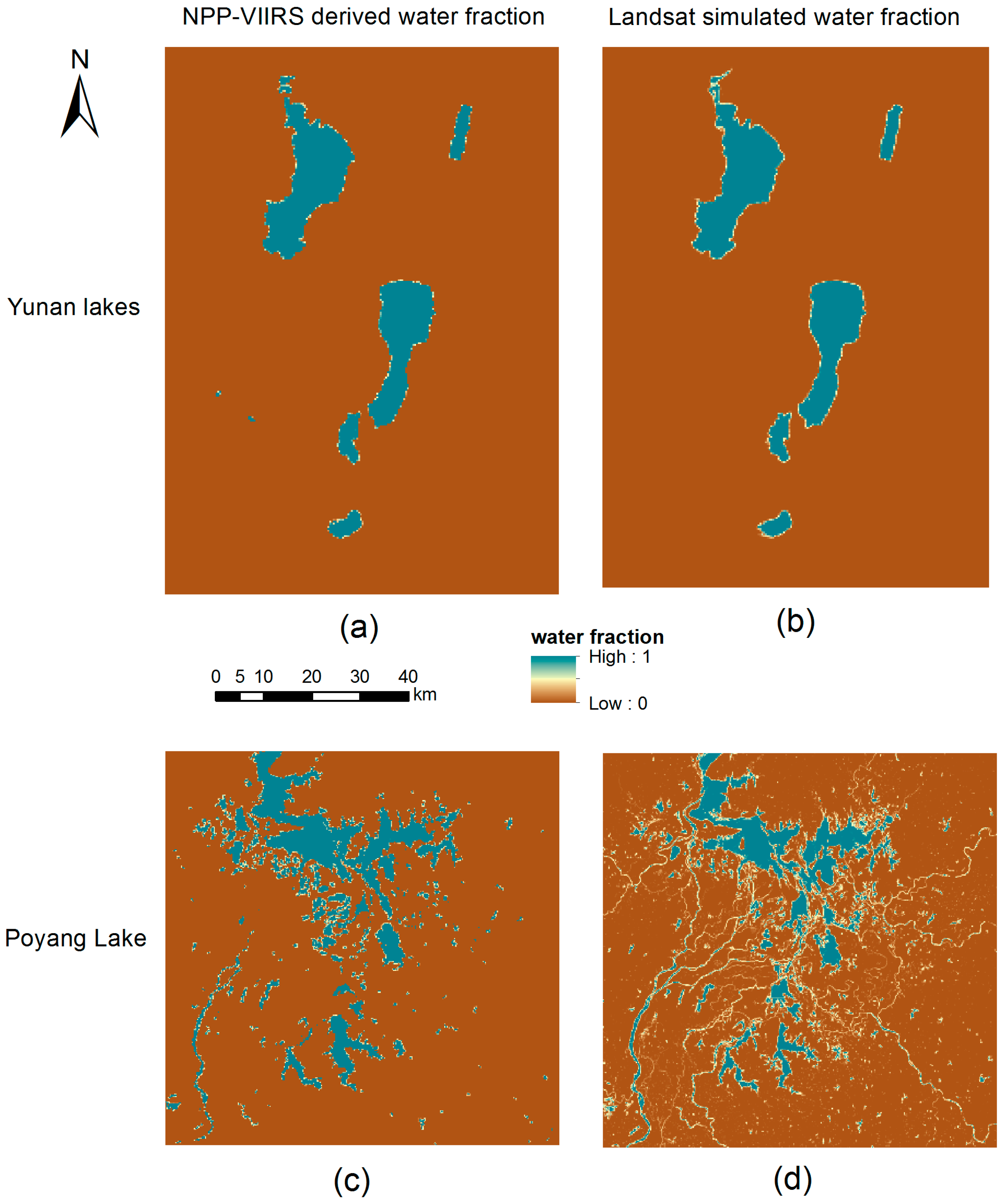
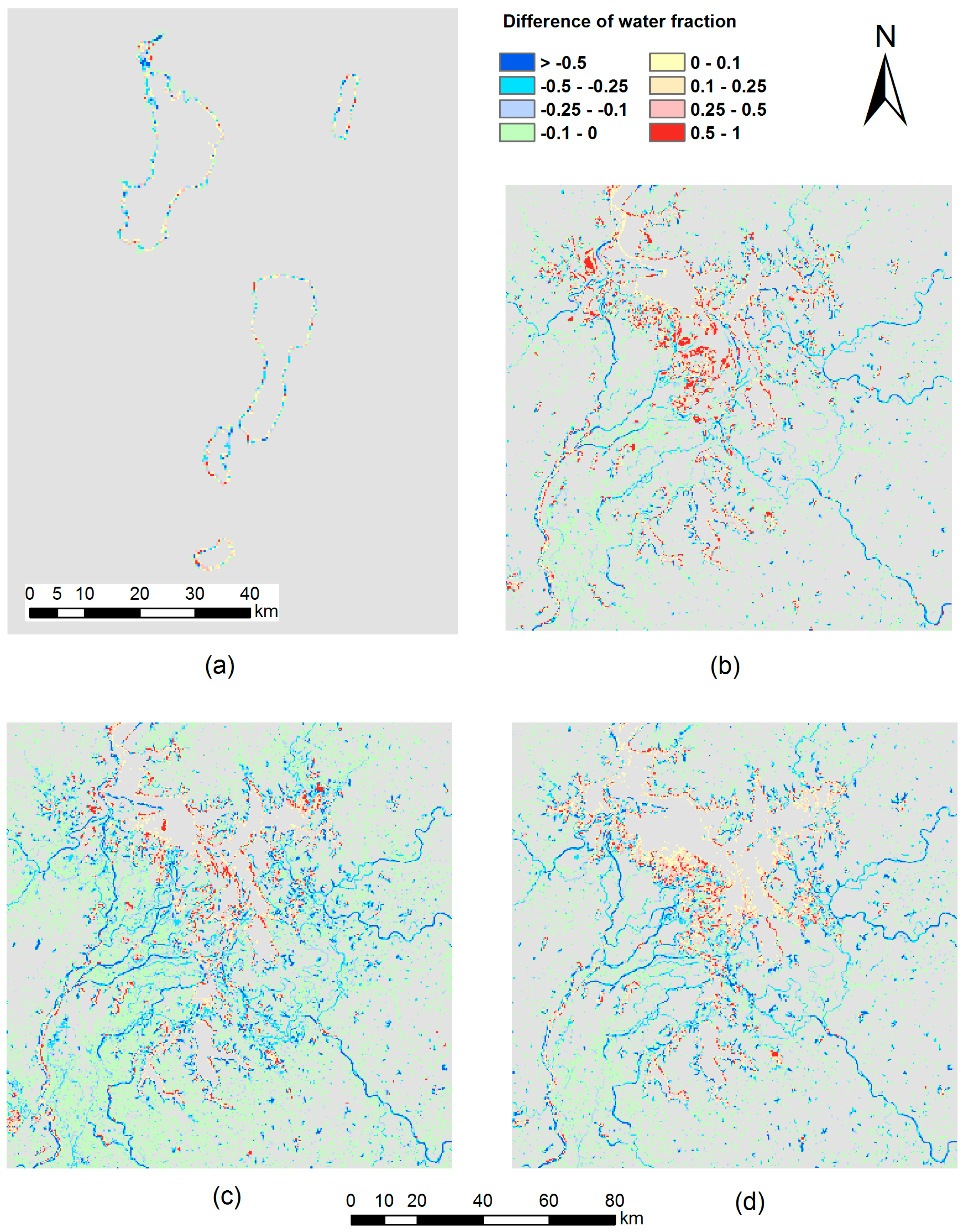
3.1. Water Fraction Map and Its Accuracy
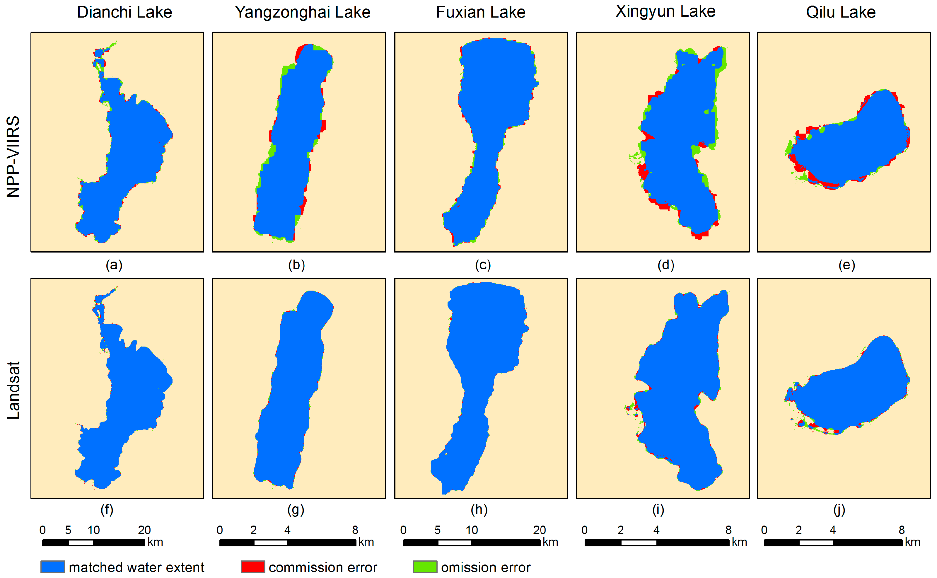
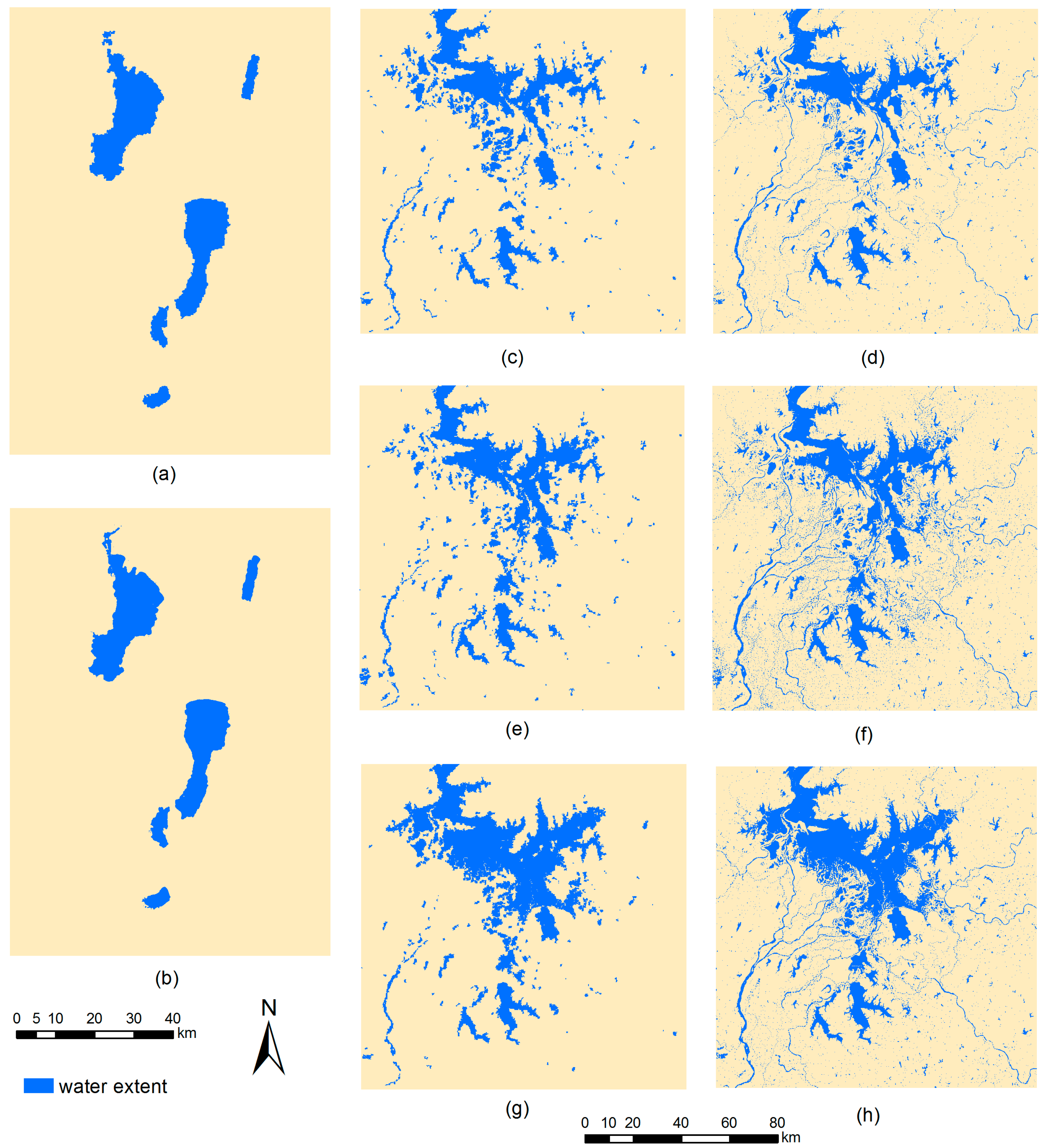
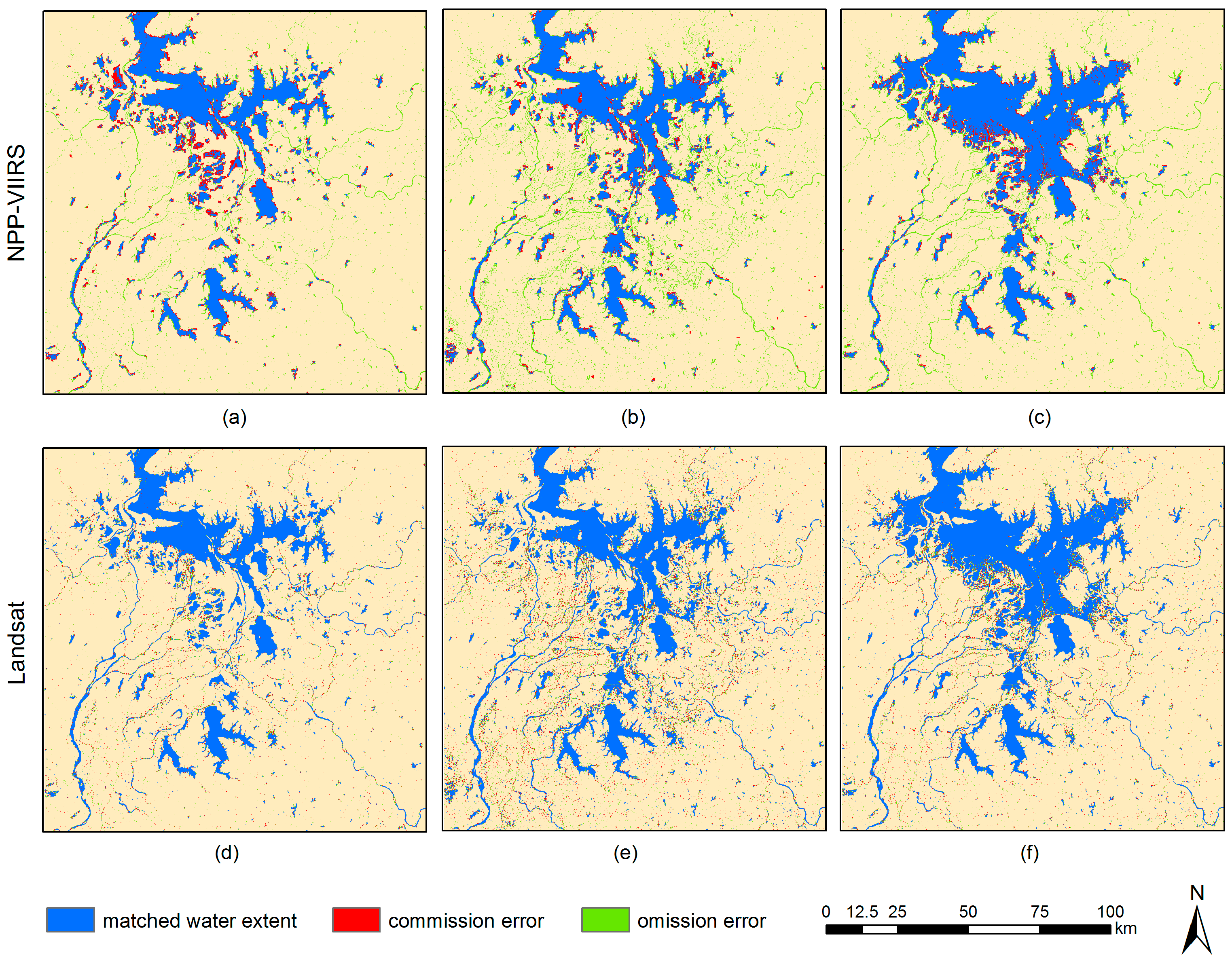
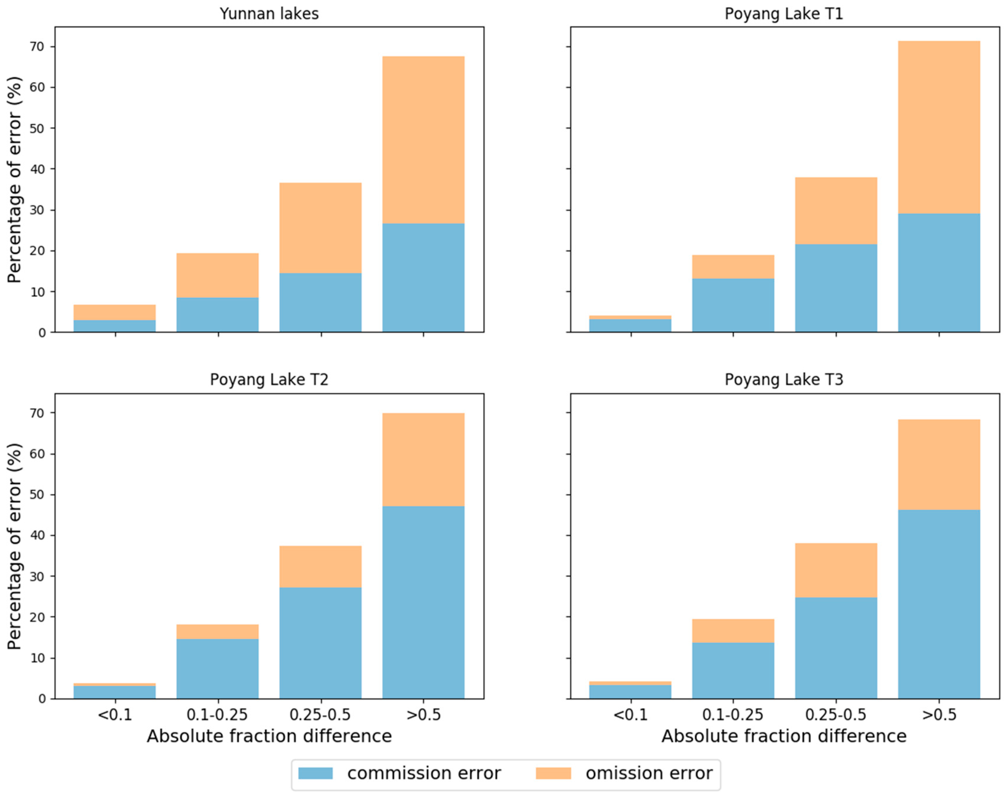
3.2. Subpixel Mapping Results and Their Accuracy
4. Conclusions
Acknowledgments
Author Contributions
Conflicts of Interest
References
- Singh, A.; Seitz, F.; Schwatke, C. Inter-annual water storage changes in the Aral Sea from multi-mission satellite altimetry, optical remote sensing, and GRACE satellite gravimetry. Remote Sens. Environ. 2012, 123, 187–195. [Google Scholar] [CrossRef]
- Lee, H.; Durand, M.; Jung, H.C.; Alsdorf, D.; Shum, C.K.; Sheng, Y. Characterization of surface water storage changes in arctic lakes using simulated SWOT measurements. Int. J. Remote Sens. 2010, 31, 3931–3953. [Google Scholar] [CrossRef]
- Haas, E.M.; Bartholomé, E.; Lambin, E.F.; Vanacker, V. Remotely sensed surface water extent as an indicator of short-term changes in ecohydrological processes in sub-Saharan Western Africa. Remote Sens. Environ. 2011, 115, 3436–3445. [Google Scholar] [CrossRef]
- Huang, S.; Dahal, D.; Young, C.; Chander, G.; Liu, S. Integration of palmer drought severity index and remote sensing data to simulate wetland water surface from 1910 to 2009 in Cottonwood Lake area, North Dakota. Remote Sens. Environ. 2011, 115, 3377–3389. [Google Scholar] [CrossRef]
- McCullough, I.M.; Loftin, C.S.; Sader, S.A. Combining lake and watershed characteristics with Landsat TM data for remote estimation of regional lake clarity. Remote Sens. Environ. 2012, 123, 109–115. [Google Scholar] [CrossRef]
- Ding, X.W.; Li, X.F. Monitoring of the water-area variations of Lake Dongting in China with ENVISAT ASAR images. Int. J. Appl. Earth Obs. Geoinf. 2011, 13, 894–901. [Google Scholar] [CrossRef]
- Zeng, L.; Schmitt, M.; Li, L.; Zhu, X.X. Analysing changes of the Poyang Lake water area using Sentinel-1 synthetic aperture radar imagery. Int. J. Remote Sens. 2017, 38, 7041–7069. [Google Scholar] [CrossRef]
- Huang, C.; Nguyen, B.D.; Zhang, S.Q.; Cao, S.M.; Wagner, W. A Comparison of Terrain Indices toward Their Ability in Assisting Surface Water Mapping from Sentinel-1 Data. ISPRS Int. J. Geo-Inf. 2017, 6, 140. [Google Scholar] [CrossRef]
- Frazier, P.S.; Page, K.J. Water body detection and delineation with Landsat TM data. Photogramm. Eng. Remote Sens. 2000, 66, 1461–1467. [Google Scholar]
- Chen, Y.; Wang, B.; Pollino, C.A.; Cuddy, S.M.; Merrin, L.E.; Huang, C. Estimate of flood inundation and retention on wetlands using remote sensing and GIS. Ecohydrology 2014, 7, 1412–1420. [Google Scholar] [CrossRef]
- Du, Z.; Li, W.; Zhou, D.; Tian, L.; Ling, F.; Wang, H.; Gui, Y.; Sun, B. Analysis of Landsat-8 OLI imagery for land surface water mapping. Remote Sens. Lett. 2014, 5, 672–681. [Google Scholar] [CrossRef]
- Sheng, Y.; Gong, P.; Xiao, Q. Quantitative dynamic flood monitoring with NOAA AVHRR. Int. J. Remote Sens. 2001, 22, 1709–1724. [Google Scholar] [CrossRef]
- Barton, I.J.; Bathols, J.M. Monitoring floods with AVHRR. Remote Sens. Environ. 1989, 30, 89–94. [Google Scholar] [CrossRef]
- Chen, Y.; Huang, C.; Ticehurst, C.; Merrin, L.; Thew, P. An evaluation of MODIS daily and 8-day composite products for floodplain and wetland inundation mapping. Wetlands 2013, 33, 823–835. [Google Scholar] [CrossRef]
- Huang, C.; Chen, Y.; Wu, J. Mapping spatio-temporal flood inundation dynamics at large river basin scale using time-series flow data and MODIS imagery. Int. J. Appl. Earth Obs. Geoinf. 2014, 26, 350–362. [Google Scholar] [CrossRef]
- Feng, L.; Hu, C.M.; Chen, X.L.; Cai, X.B.; Tian, L.Q.; Gan, W.X. Assessment of inundation changes of Poyang Lake using MODIS observations between 2000 and 2010. Remote Sens. Environ. 2012, 121, 80–92. [Google Scholar] [CrossRef]
- Xu, H.Q. Modification of normalised difference water index (NDWI) to enhance open water features in remotely sensed imagery. Int. J. Remote Sens. 2006, 27, 3025–3033. [Google Scholar] [CrossRef]
- Li, S.; Sun, D.; Yu, Y.; Csiszar, I.; Stefanidis, A.; Goldberg, M.D. A new short-wave infrared (SWIR) method for quantitative water fraction derivation and evaluation with EOS/MODIS and Landsat/TM data. IEEE Trans. Geosci. Remote Sens. 2013, 51, 1852–1862. [Google Scholar] [CrossRef]
- Shi, K.; Huang, C.; Yu, B.; Yin, B.; Huang, Y.; Wu, J. Evaluation of NPP-VIIRS night-time light composite data for extracting built-up urban areas. Remote Sens. Lett. 2014, 5, 358–366. [Google Scholar] [CrossRef]
- Yu, Y.; Privette, J.L.; Pinheiro, A.C. Analysis of the NPOESS VIIRS land surface temperature algorithm using MODIS data. IEEE Trans. Geosci. Remote Sens. 2005, 43, 2340–2350. [Google Scholar]
- Huang, C.; Chen, Y.; Wu, J.; Li, L.; Liu, R. An evaluation of Suomi NPP-VIIRS data for surface water detection. Remote Sens. Lett. 2015, 6, 155–164. [Google Scholar] [CrossRef]
- Olthof, I.; Fraser, R.H.; Schmitt, C. Landsat-based mapping of thermokarst lake dynamics on the Tuktoyaktuk Coastal Plain, Northwest Territories, Canada since 1985. Remote Sens. Environ. 2015, 168, 194–204. [Google Scholar] [CrossRef]
- Mueller, N.; Lewis, A.; Roberts, D.; Ring, S.; Melrose, R.; Sixsmith, J.; Lymburner, L.; McIntyre, A.; Tan, P.; Curnow, S.; et al. Water observations from space: Mapping surface water from 25 years of Landsat imagery across Australia. Remote Sens. Environ. 2016, 174, 341–352. [Google Scholar] [CrossRef]
- Pekel, J.-F.; Cottam, A.; Gorelick, N.; Belward, A.S. High-resolution mapping of global surface water and its long-term changes. Nature 2016, 540, 418–422. [Google Scholar] [CrossRef] [PubMed]
- Donchyts, G.; Baart, F.; Winsemius, H.; Gorelick, N.; Kwadijk, J.; van de Giesen, N. Earth’s surface water change over the past 30 years. Nat. Clim. Chang. 2016, 6, 810–813. [Google Scholar] [CrossRef]
- Yamazaki, D.; Trigg, M.A. Hydrology: The dynamics of earth’s surface water. Nature 2016, 540, 348–349. [Google Scholar] [CrossRef] [PubMed]
- Keshava, N.; Mustard, J.F. Spectral unmixing. IEEE Signal Process. Mag. 2002, 19, 44–57. [Google Scholar] [CrossRef]
- Keshava, N. A survey of spectral unmixing algorithms. Linc. Lab. J. 2003, 14, 55–78. [Google Scholar]
- Ma, B.; Wu, L.; Zhang, X.; Li, X.; Liu, Y.; Wang, S. Locally adaptive unmixing method for lake-water area extraction based on MODIS 250m bands. Int. J. Appl. Earth Obs. Geoinf. 2014, 33, 109–118. [Google Scholar] [CrossRef]
- Atkinson, P.M.; Cutler, M.E.J.; Lewis, H. Mapping sub-pixel proportional land cover with AVHRR imagery. Int. J. Remote Sens. 1997, 18, 917–935. [Google Scholar] [CrossRef]
- Tatem, A.J.; Lewis, H.G.; Atkinson, P.M.; Nixon, M.S. Super-resolution land cover pattern prediction using a hopfield neural network. Remote Sens. Environ. 2002, 79, 1–14. [Google Scholar] [CrossRef]
- Mertens, K.C.; Verbeke, L.P.C.; Ducheyne, E.I.; De Wulf, R.R. Using genetic algorithms in sub-pixel mapping. Int. J. Remote Sens. 2003, 24, 4241–4247. [Google Scholar] [CrossRef]
- Li, L.; Chen, Y.; Xu, T.; Liu, R.; Shi, K.; Huang, C. Super-resolution mapping of wetland inundation from remote sensing imagery based on integration of back-propagation neural network and genetic algorithm. Remote Sens. Environ. 2015, 164, 142–154. [Google Scholar] [CrossRef]
- Mertens, K.C.; De Baets, B.; Verbeke, L.P.C.; De Wulf, R.R. A sub-pixel mapping algorithm based on sub-pixel/pixel spatial attraction models. Int. J. Remote Sens. 2006, 27, 3293–3310. [Google Scholar] [CrossRef]
- Ling, F.; Li, X.D.; Du, Y.; Xiao, F. Sub-pixel mapping of remotely sensed imagery with hybrid intra- and inter-pixel dependence. Int. J. Remote Sens. 2013, 34, 341–357. [Google Scholar] [CrossRef]
- Ling, F.; Du, Y.; Xiao, F.; Xue, H.P.; Wu, S.J. Super-resolution land-cover mapping using multiple sub-pixel shifted remotely sensed images. Int. J. Remote Sens. 2010, 31, 5023–5040. [Google Scholar] [CrossRef]
- Atkinson, P.M. Sub-pixel target mapping from soft-classified, remotely sensed imagery. Photogramm. Eng. Remote Sens. 2005, 71, 839–846. [Google Scholar] [CrossRef]
- Thornton, M.W.; Atkinson, P.M.; Holland, D.A. A linearised pixel-swapping method for mapping rural linear land cover features from fine spatial resolution remotely sensed imagery. Comput. Geosci. 2007, 33, 1261–1272. [Google Scholar] [CrossRef]
- Huang, C.; Chen, Y.; Wu, J.P. Dem-based modification of pixel-swapping algorithm for enhancing floodplain inundation mapping. Int. J. Remote Sens. 2014, 35, 365–381. [Google Scholar] [CrossRef]
- Ling, F.; Fang, S.; Li, W.; Li, X.; Xiao, F.; Zhang, Y.; Du, Y. Post-processing of interpolation-based super-resolution mapping with morphological filtering and fraction refilling. Int. J. Remote Sens. 2014, 35, 5251–5262. [Google Scholar] [CrossRef]
- Li, L.; Chen, Y.; Yu, X.; Liu, R.; Huang, C. Sub-pixel flood inundation mapping from multispectral remotely sensed images based on discrete particle swarm optimization. ISPRS J. Photogramm. Remote Sens. 2015, 101, 10–21. [Google Scholar] [CrossRef]
- Foody, G.M.; Muslim, A.M.; Atkinson, P.M. Super-resolution mapping of the waterline from remotely sensed data. Int. J. Remote Sens. 2005, 26, 5381–5392. [Google Scholar] [CrossRef]
- Ling, F.; Xiao, F.; Du, Y.; Xue, H.P.; Ren, X.Y. Waterline mapping at the subpixel scale from remote sensing imagery with high-resolution digital elevation models. Int. J. Remote Sens. 2008, 29, 1809–1815. [Google Scholar] [CrossRef]
- Muslim, A.M.; Foody, G.M.; Atkinson, P.M. Localized soft classification for super-resolution mapping of the shoreline. Int. J. Remote Sens. 2006, 27, 2271–2285. [Google Scholar] [CrossRef]
- Muad, A.M.; Foody, G.M. Super-resolution mapping of lakes from imagery with a coarse spatial and fine temporal resolution. Int. J. Appl. Earth Obs. Geoinf. 2012, 15, 79–91. [Google Scholar] [CrossRef]
- Shah, C.A. Automated lake shoreline mapping at subpixel accuracy. IEEE Geosci. Remote Sens. Lett. 2011, 8, 1125–1129. [Google Scholar] [CrossRef]
- Pardo-Pascual, J.E.; Almonacid-Caballer, J.; Ruiz, L.A.; Palomar-Vazquez, J. Automatic extraction of shorelines from Landsat TM and ETM+ multi-temporal images with subpixel precision. Remote Sens. Environ. 2012, 123, 1–11. [Google Scholar] [CrossRef]
- Xu, G.; Qin, Z. Flood estimation methods for Poyang Lake area. J. Lake Sci. 1998, 10, 31–36. [Google Scholar]
- Shankman, D.; Keim, B.D.; Song, J. Flood frequency in China’s Poyang Lake region: Trends and teleconnections. Int. J. Climatol. 2006, 26, 1255–1266. [Google Scholar] [CrossRef]
- Haertel, V.F.; Shimabukuro, Y.E. Spectral linear mixing model in low spatial resolution image data. IEEE Trans. Geosci. Remote Sens. 2005, 43, 2555–2562. [Google Scholar] [CrossRef]
- Verdin, J.P. Remote sensing of ephemeral water bodies in western Niger. Int. J. Remote Sens. 1996, 17, 733–748. [Google Scholar] [CrossRef]
- Pontius, R.G., Jr.; Cheuk, M.L. A generalized cross-tabulation matrix to compare soft-classified maps at multiple resolutions. Int. J. Geogr. Inf. Sci. 2006, 20, 1–30. [Google Scholar] [CrossRef]
- Silván-Cárdenas, J.L.; Wang, L. Sub-pixel confusion–uncertainty matrix for assessing soft classifications. Remote Sens. Environ. 2008, 112, 1081–1095. [Google Scholar] [CrossRef]
- Landis, J.R.; Koch, G.G. The measurement of observer agreement for categorical data. Biometrics 1977, 33, 159–174. [Google Scholar] [CrossRef] [PubMed]


| Case Study | Image Type | Image Date | Acquisition Time | Path/Row | Spatial Resolution |
|---|---|---|---|---|---|
| Yunnan lakes | NPP-VIIRS | 2 February 2014 | 06:39:57 | -- | 375 m |
| Landsat OLI | 2 February 2014 | 03:36:02 | 129/43 | 30 m | |
| Poyang Lake T1 | NPP-VIIRS | 5 October 2013 | 05:52:14 | -- | 375 m |
| Landsat OLI | 5 October 2013 | 02:46:14 | 121/40 | 30 m | |
| Poyang Lake T2 | NPP-VIIRS | 1 May 2014 | 05:53:21 | -- | 375 m |
| Landsat OLI | 1 May 2014 | 02:44:05 | 121/40 | 30 m | |
| Poyang Lake T3 | NPP-VIIRS | 8 October 2014 | 05:52:50 | -- | 375 m |
| Landsat OLI | 8 October 2014 | 02:44:32 | 121/40 | 30 m |
| Case Study | Percentage of Pixels that Have an Absolute Difference | |||
|---|---|---|---|---|
| <0.10 | 0.10–0.25 | 0.25–0.50 | >0.50 | |
| Yunnan lakes | 39% | 27% | 24% | 10% |
| Poyang Lake T1 | 53% | 19% | 16% | 12% |
| Poyang Lake T2 | 61% | 18% | 13% | 8% |
| Poyang Lake T3 | 54% | 20% | 16% | 10% |
| Case Study | Lake | Lake Area on NPP-VIIRS (km2) | Lake Area on Landsat (km2) | Difference (%) |
|---|---|---|---|---|
| Yunnan lakes | Dianchi Lake | 289.30 | 294.26 | 1.69 |
| Yangzonghai Lake | 28.84 | 29.47 | 2.14 | |
| Fuxian Lake | 212.40 | 213.83 | 0.67 | |
| Xingyun Lake | 31.13 | 31.86 | 2.29 | |
| Qilu Lake | 23.80 | 22.59 | 5.36 | |
| Poyang Lake T1 | Poyang Lake | 2011.32 | 2093.30 | 3.92 |
| Poyang Lake T2 | Poyang Lake | 2107.93 | 2277.45 | 7.44 |
| Poyang Lake T3 | Poyang Lake | 2666.81 | 2766.85 | 3.62 |
| Case Study | Lake | Producer Accuracy (%) with Uncertainty | User Accuracy (%) with Uncertainty | Overall Accuracy (%) with Uncertainty | Kappa Coefficient with Uncertainty |
|---|---|---|---|---|---|
| Yunnan lakes | Dianchi Lake | 95.33 ± 1.05 | 96.95 ± 1.09 | 97.94 ± 0.58 | 0.95 ± 0.02 |
| Yangzonghai Lake | 92.09 ± 1.78 | 94.09 ± 1.86 | 98.26 ± 0.48 | 0.92 ± 0.02 | |
| Fuxian Lake | 96.91 ± 0.80 | 97.56 ± 0.81 | 97.94 ± 0.60 | 0.96 ± 0.01 | |
| Xingyun Lake | 90.17 ± 1.92 | 92.22 ± 2.01 | 95.09 ± 1.14 | 0.88 ± 0.03 | |
| Qilu Lake | 93.94 ± 2.52 | 89.29 ± 2.28 | 95.93 ± 1.20 | 0.89 ± 0.03 | |
| Poyang Lake T1 | Poyang Lake | 75.46 ± 1.72 | 78.47 ± 1.86 | 94.70 ± 0.50 | 0.74 ± 0.03 |
| Poyang Lake T2 | Poyang Lake | 63.28 ± 1.27 | 82.88 ± 2.18 | 92.30 ± 0.57 | 0.67 ± 0.03 |
| Poyang Lake T3 | Poyang Lake | 75.70 ± 1.58 | 86.80 ± 2.07 | 93.88 ± 0.67 | 0.77 ± 0.03 |
| Case Study | Lake | Downscaling Data Source | Commission Error (%) | Omission Error (%) | Overall Accuracy (%) | Kappa Coefficient |
|---|---|---|---|---|---|---|
| Yunnan lakes | Dianchi Lake | NPP-VIIRS | 6.81 | 12.69 | 80.50 | 0.61 |
| Landsat | 2.86 | 2.83 | 94.31 | 0.89 | ||
| Yangzonghai Lake | NPP-VIIRS | 8.42 | 13.24 | 78.34 | 0.56 | |
| Landsat | 1.59 | 1.56 | 96.85 | 0.97 | ||
| Fuxian Lake | NPP-VIIRS | 8.75 | 12.27 | 78.98 | 0.59 | |
| Landsat | 2.35 | 2.32 | 95.33 | 0.91 | ||
| Xingyun Lake | NPP-VIIRS | 9.95 | 14.62 | 75.43 | 0.51 | |
| Landsat | 2.71 | 2.66 | 94.63 | 0.89 | ||
| Qilu Lake | NPP-VIIRS | 16.25 | 6.61 | 77.14 | 0.55 | |
| Landsat | 4.34 | 4.34 | 91.32 | 0.82 | ||
| Poyang Lake T1 | Poyang Lake | NPP-VIIRS | 9.20 | 11.01 | 79.79 | 0.42 |
| Landsat | 5.43 | 5.43 | 89.14 | 0.69 | ||
| Poyang Lake T2 | Poyang Lake | NPP-VIIRS | 4.13 | 12.02 | 83.85 | 0.48 |
| Landsat | 5.74 | 5.74 | 88.52 | 0.62 | ||
| Poyang Lake T3 | Poyang Lake | NPP-VIIRS | 5.96 | 12.95 | 81.09 | 0.46 |
| Landsat | 6.26 | 6.26 | 87.48 | 0.67 |
© 2017 by the authors. Licensee MDPI, Basel, Switzerland. This article is an open access article distributed under the terms and conditions of the Creative Commons Attribution (CC BY) license (http://creativecommons.org/licenses/by/4.0/).
Share and Cite
Huang, C.; Chen, Y.; Zhang, S.; Li, L.; Shi, K.; Liu, R. Spatial Downscaling of Suomi NPP–VIIRS Image for Lake Mapping. Water 2017, 9, 834. https://doi.org/10.3390/w9110834
Huang C, Chen Y, Zhang S, Li L, Shi K, Liu R. Spatial Downscaling of Suomi NPP–VIIRS Image for Lake Mapping. Water. 2017; 9(11):834. https://doi.org/10.3390/w9110834
Chicago/Turabian StyleHuang, Chang, Yun Chen, Shiqiang Zhang, Linyi Li, Kaifang Shi, and Rui Liu. 2017. "Spatial Downscaling of Suomi NPP–VIIRS Image for Lake Mapping" Water 9, no. 11: 834. https://doi.org/10.3390/w9110834
APA StyleHuang, C., Chen, Y., Zhang, S., Li, L., Shi, K., & Liu, R. (2017). Spatial Downscaling of Suomi NPP–VIIRS Image for Lake Mapping. Water, 9(11), 834. https://doi.org/10.3390/w9110834