
Coupling Modified Linear Spectral Mixture Analysis and Soil Conservation Service Curve Number (SCS-CN) Models to Simulate Surface Runoff: Application to the Main Urban Area of Guangzhou, China


Abstract
:1. Introduction
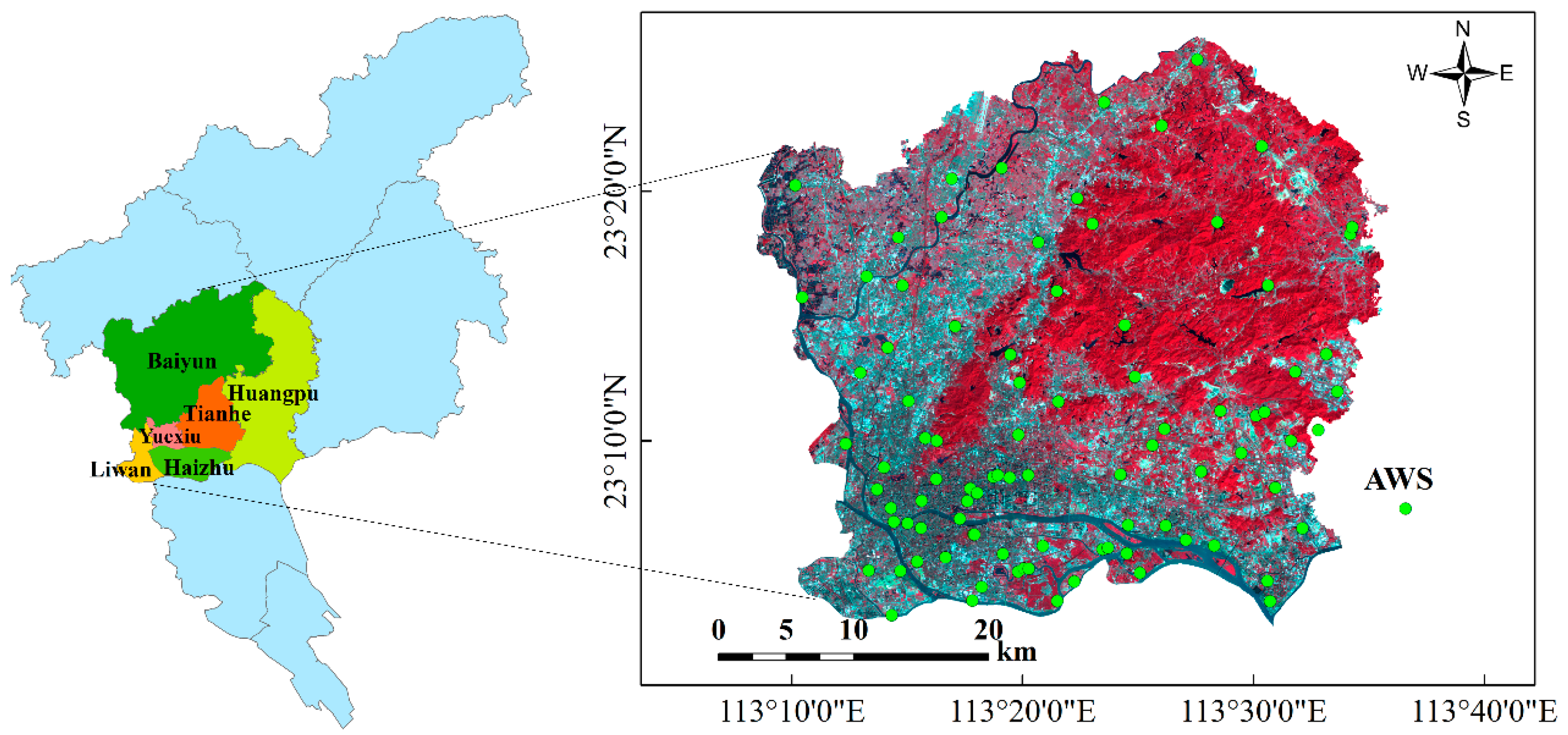
2. Study Area and Data
2.1. Study Area
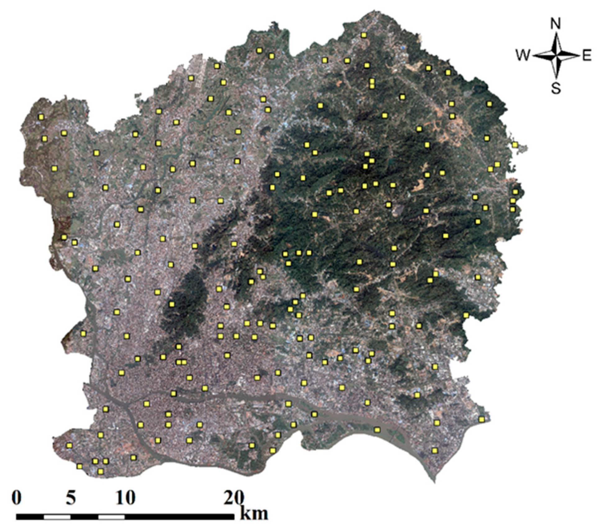
2.2. Remote Sensing Image
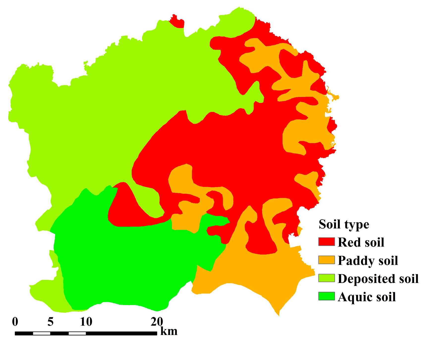
2.3. Soil Data
3. Methods
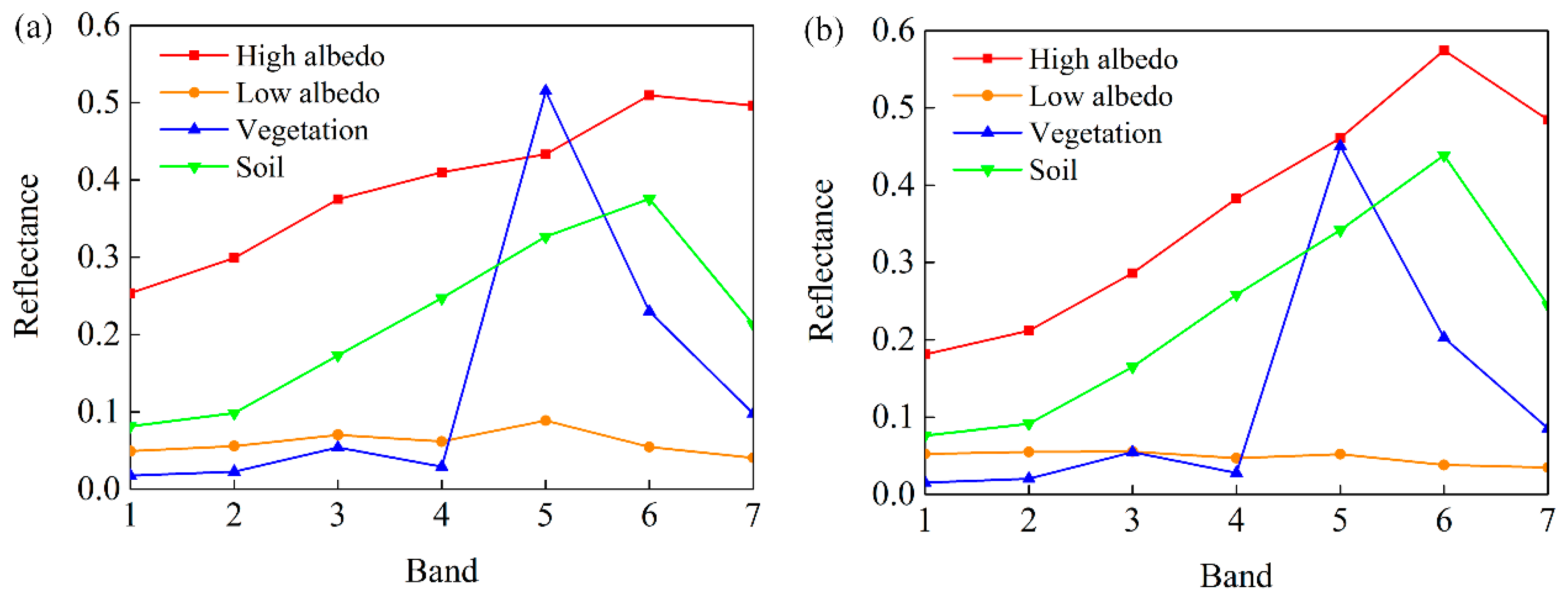
3.1. Linear Spectral Mixture Analysis
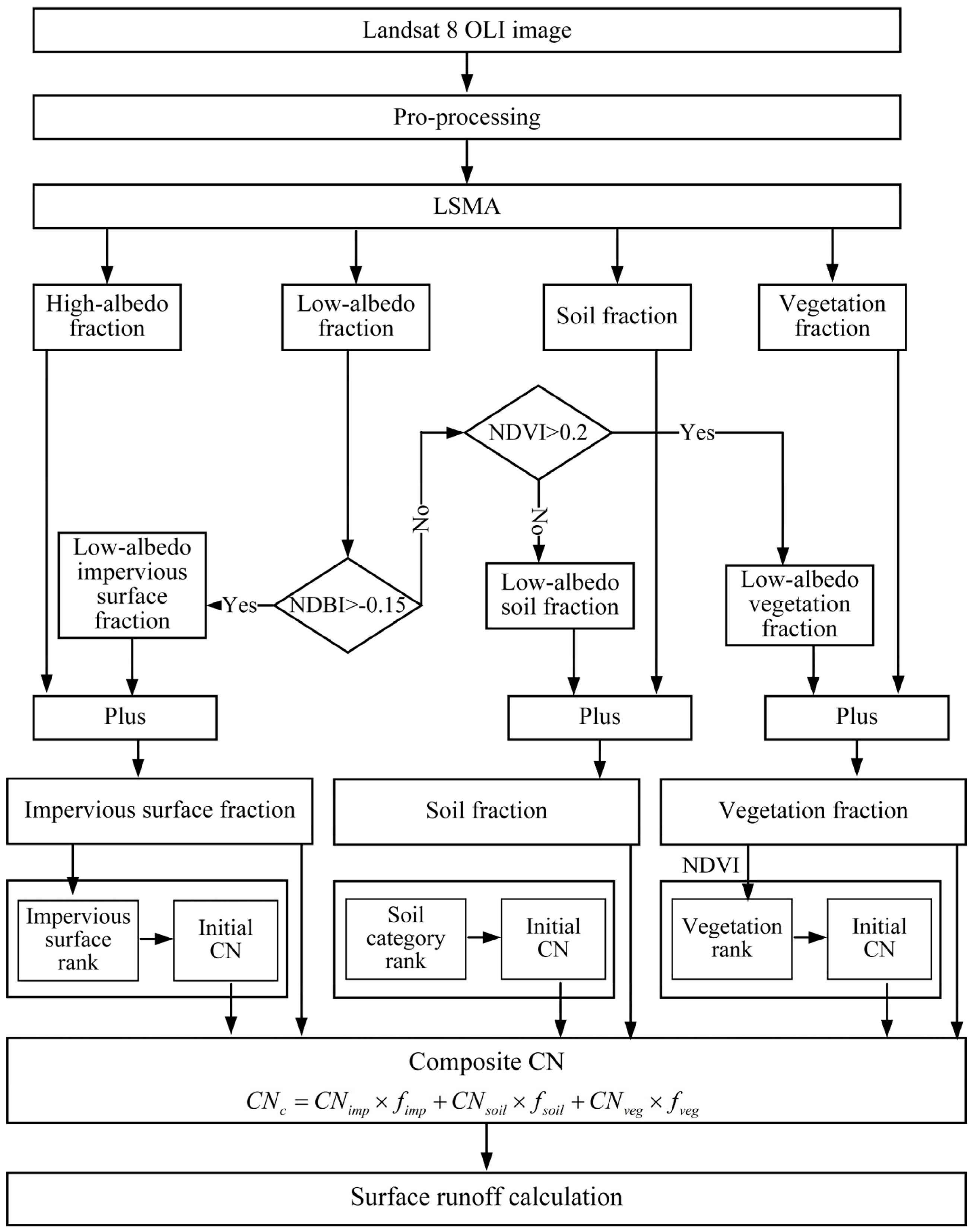
3.1.1. Modified Linear Spectral Mixture Analysis
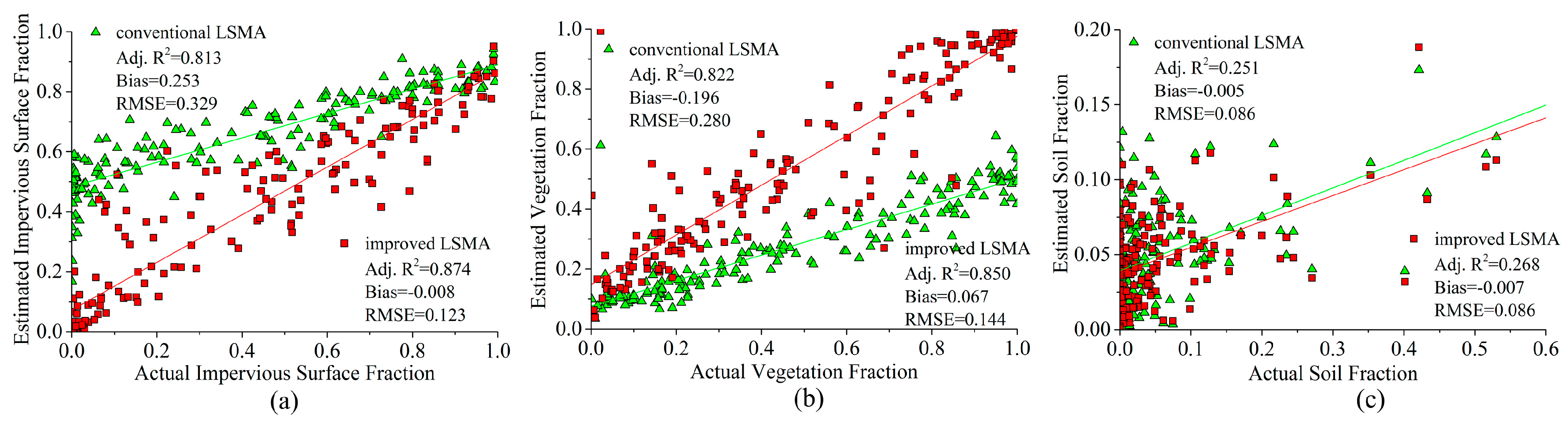
3.1.2. Accuracy Assessment
3.2. Surface Runoff Simulation
4. Results and Discussion
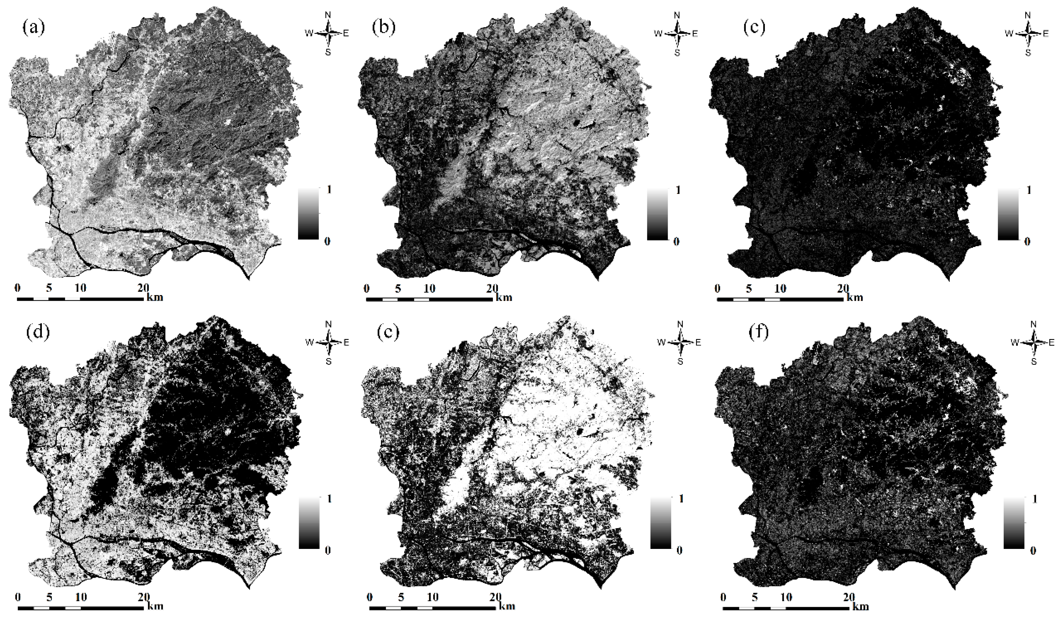
4.1. Extraction Results of the Modified LSMA
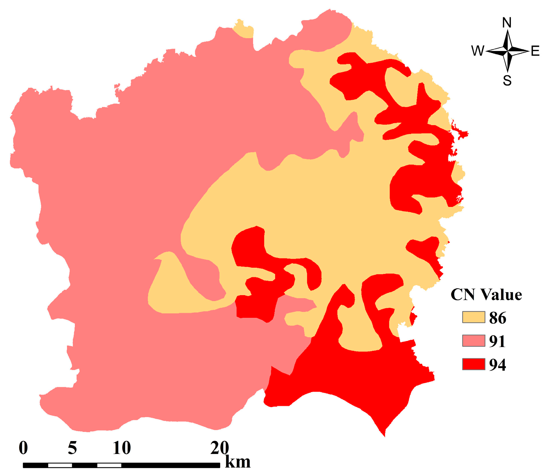
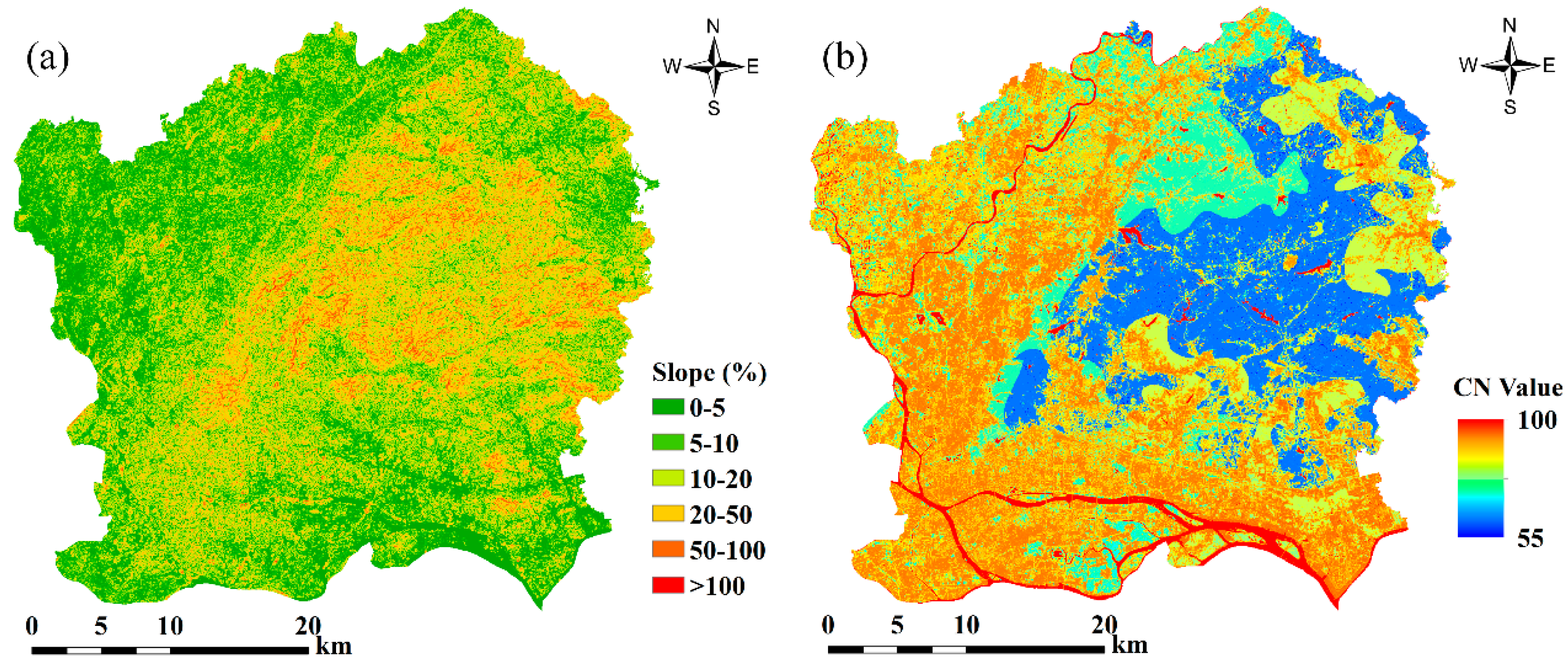
4.2. Calculation of the Composite CN
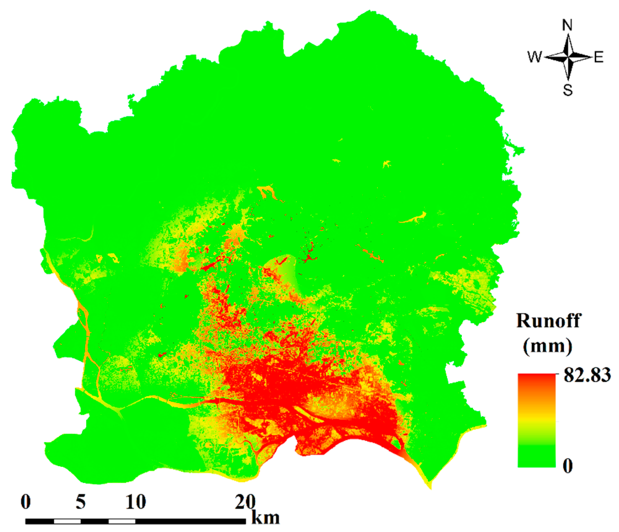
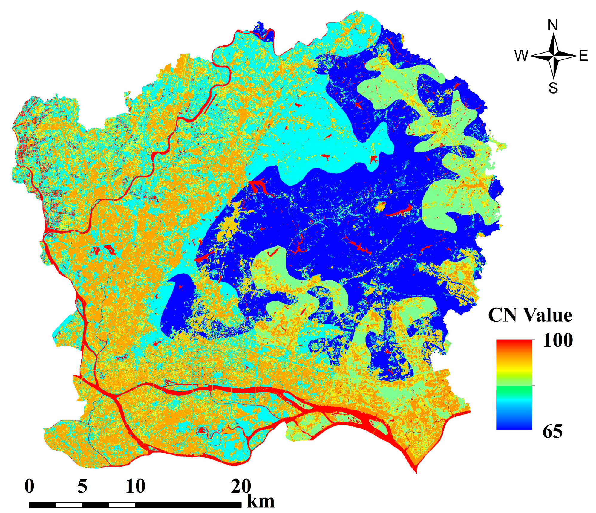
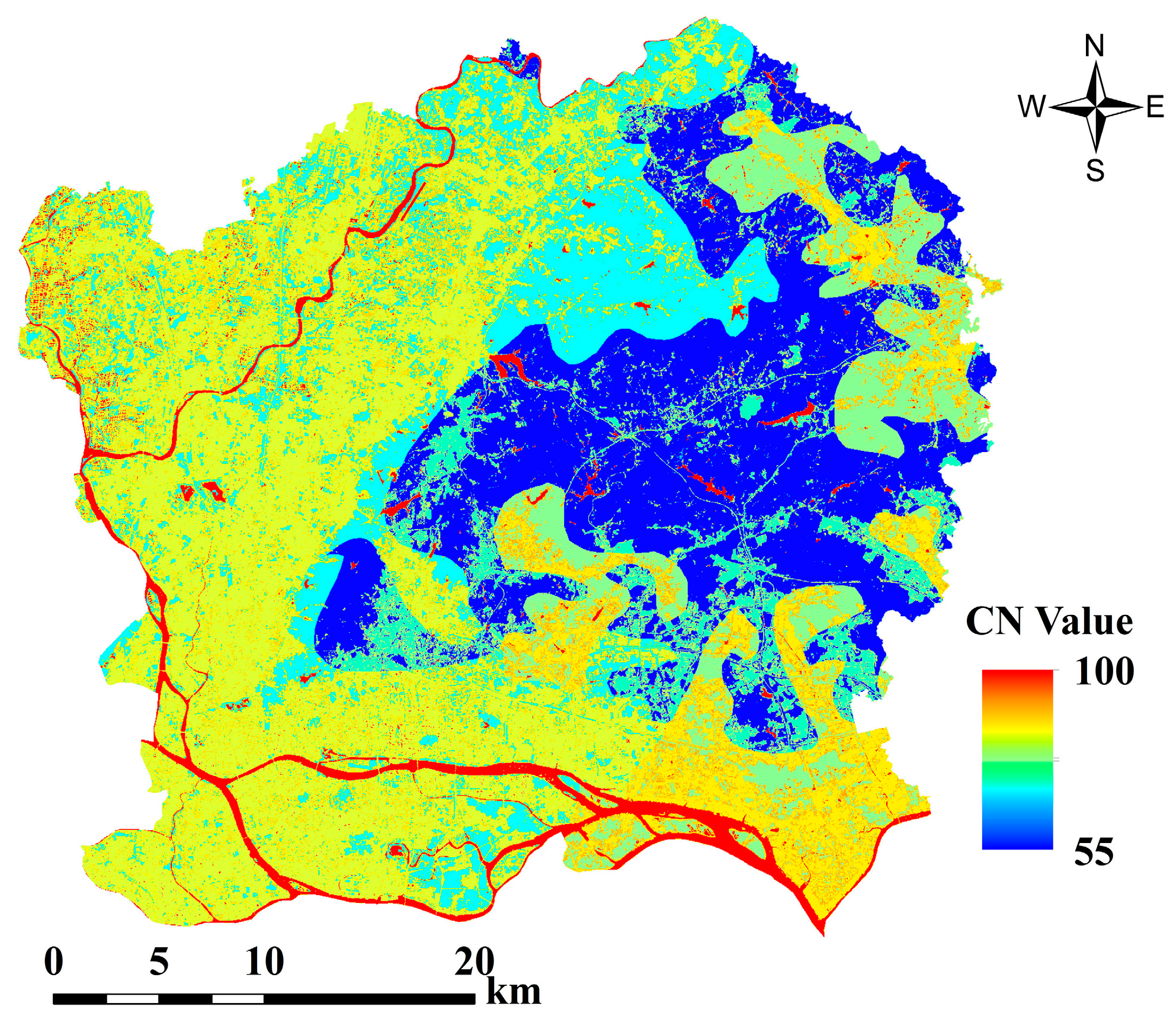
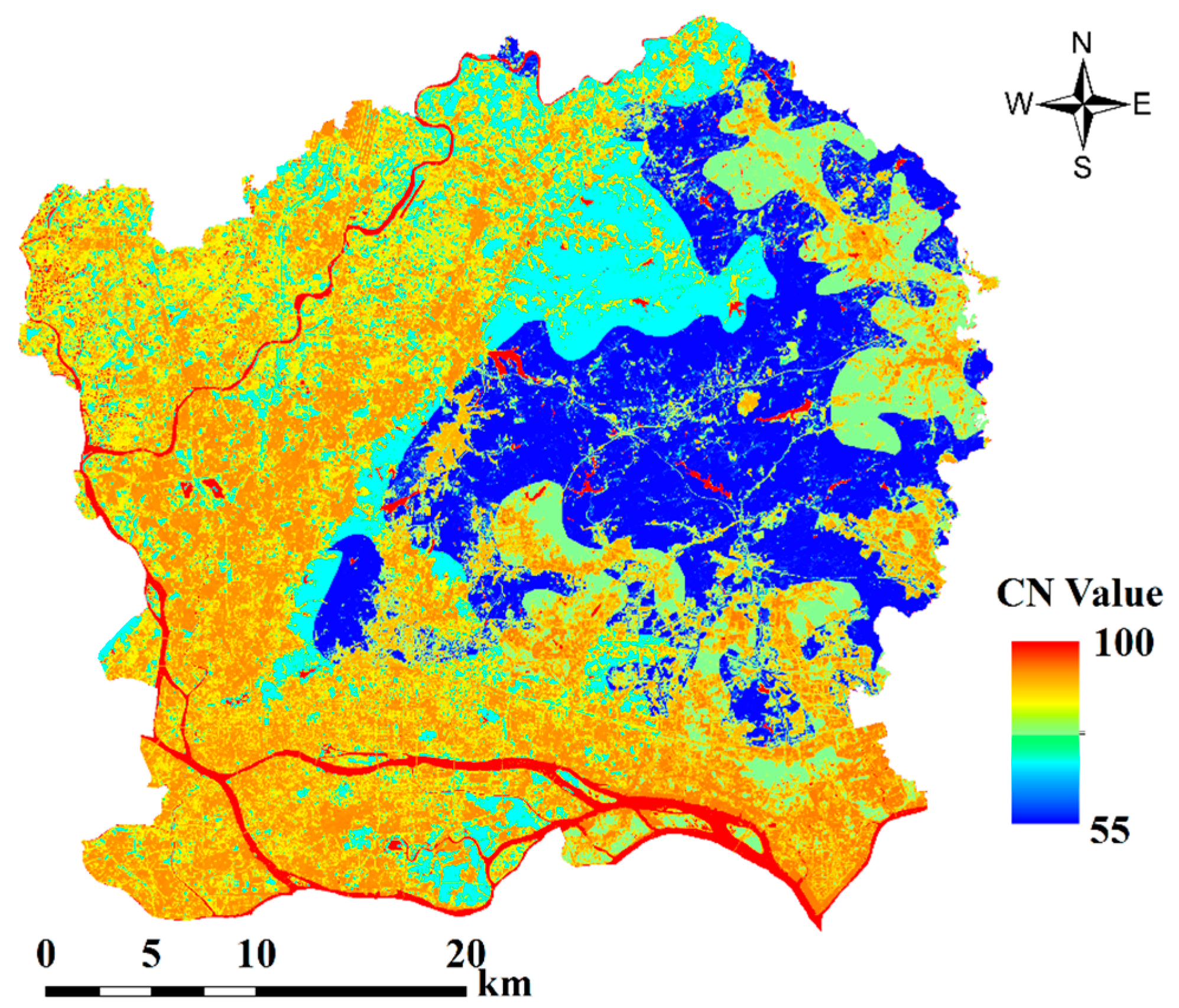
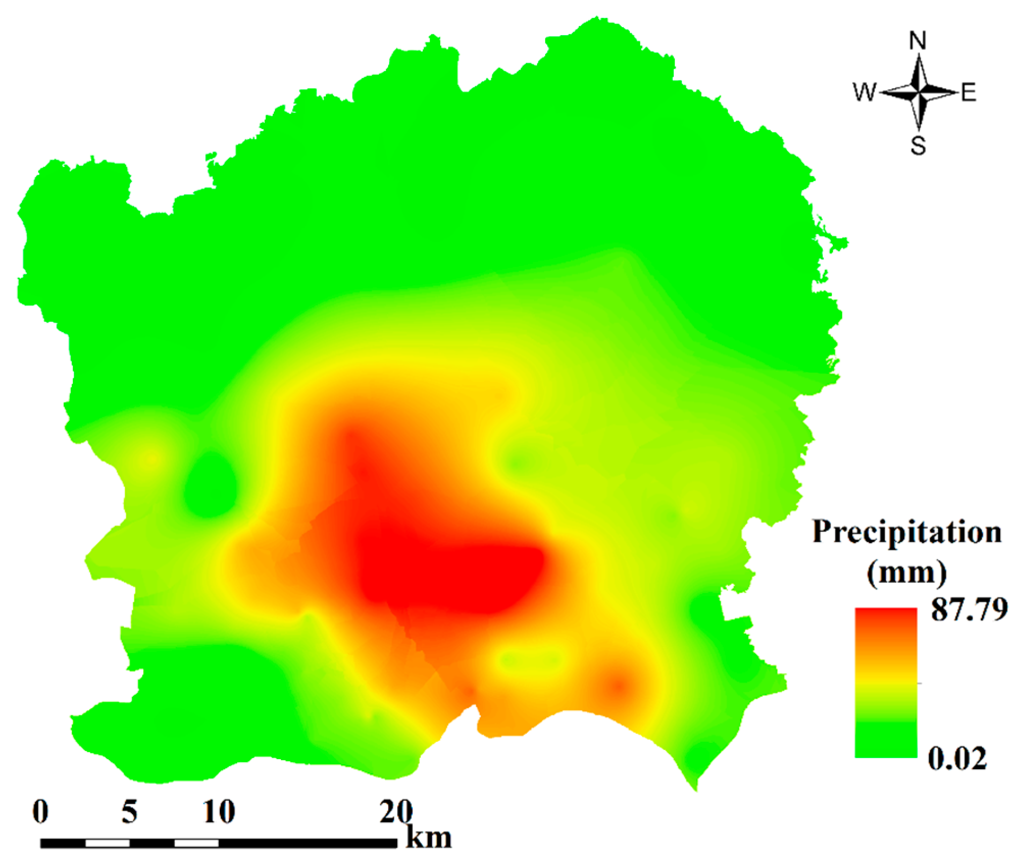
4.3. Runoff Calculation
5. Conclusions
Acknowledgments
Author Contributions
Conflicts of Interest
References
- Brabec, E.; Schulte, S.; Richards, P.L. Impervious surfaces and water quality: A review of current literature and its implications for watershed planning. J. Plan. Lit. 2002, 16, 499–514. [Google Scholar] [CrossRef]
- Gao, G.Y.; Fu, B.J.; Lu, Y.H.; Liu, Y.; Wang, S.; Zhou, J.M. Coupling the modified SCS-CN and rusle models to simulate hydrological effects of restoring vegetation in the loess plateau of China. Hydrol. Earth Syst. Sci. 2012, 16, 2347–2364. [Google Scholar] [CrossRef]
- Yao, L.; Wei, W.; Yu, Y.; Xiao, J.; Chen, L. Research on potential runoff risk of urban functional zones in beijing city based on GIS and RS. Acta Geogr. Sin. 2015, 70, 308–318. (In Chinese) [Google Scholar]
- National Engineering Handbook. 2009. Available online: http://directives.sc.egov.usda.gov/OpenNonWebContent.aspx?content=22526.wba (accessed on 26 January 2009).
- Ponce, V.M.; Hawkins, R.H. Runoff curve number: Has it reached maturity? J. Hydrol. Eng. 1996, 1, 11–19. [Google Scholar] [CrossRef]
- Geetha, K.; Mishra, S.K.; Eldho, T.I.; Rastogi, A.K.; Pandey, R.P. SCS-CN-based continuous simulation model for hydrologic forecasting. Water Resour. Manag. 2007, 22, 165–190. [Google Scholar] [CrossRef]
- Anubha, T.; Singh, A.K.; Vaishya, R.C. SCS CN runoff estimation for vindhyachal region using remote sensing and GIS. Int. J. Adv. Remote Sens. GIS 2015, 4, 1214–1223. [Google Scholar]
- Xiao, B.; Wang, Q.-H.; Fan, J.; Han, F.-P.; Dai, Q.-H. Application of the SCS-CN model to runoff estimation in a small watershed with high spatial heterogeneity. Pedosphere 2011, 21, 738–749. [Google Scholar] [CrossRef]
- Choi, J.; Engel, B.A.; Chung, H.W. Daily streamflow modelling and assessment based on the curve-number technique. Hydrol. Process. 2002, 16, 3131–3150. [Google Scholar] [CrossRef]
- Soulis, K.X.; Dercas, N. Development of a gis-based spatially distributed continuous hydrological model and its first application. Water Int. 2009, 32, 177–192. [Google Scholar] [CrossRef]
- Neitsch, S.L.; Arnold, J.G.; Kiniry, J.R.; Williams, J.R. Soil and Water Assessment Tool Theoretical Documentation: Version 2009; Texas Water Resources Institute Technical Report 406; Texas A & M University System: College Station, TX, USA, 2009. [Google Scholar]
- Harbor, J.M. A practical method for estimating the impact of land-use change on surface runoff, groundwater recharge and wetland hydrology. J. Am. Plan. Assoc. 2007, 60, 95–108. [Google Scholar] [CrossRef]
- United States Army Corps of Engineers (USACE). Hydrologic Modeling System HEC-HMS, User’s Manual; Version 4.0; United States Army Corps of Engineers: Washington, DC, USA, 2013.
- Sharpley, A.N.; Williams, J.R. Epic-Erosion/Productivity Impact Calculator: 1. Model Documentation; Technical Bulletin 1768; U.S. Department of Agriculture: Washington, DC, USA, 1990; p. 235.
- Young, R.A.; Onstad, C.A.; Bosch, D.D.; Anderson, W.P. Agnps: A nonpoint-source pollution model for evaluating agricultural watersheds. J. Soil Water Conserv. 1989, 44, 168–173. [Google Scholar]
- Rejani, R.; Rao, K.V.; Osman, M.; Chary, G.R.; Pushpanjali; Reddy, K.S.; Rao, C.S. Spatial and temporal estimation of runoff in a semi-arid microwatershed of Southern India. Environ. Monit. Assess. 2015, 187. [Google Scholar] [CrossRef] [PubMed]
- Suribabu, C.R.; Bhaskar, J. Evaluation of urban growth effects on surface runoff using SCS-CN method and green-ampt infiltration model. Earth Sci. Inf. 2014, 8, 609–626. [Google Scholar] [CrossRef]
- Kowalik, T.; Walega, A. Estimation of cn parameter for small agricultural watersheds using asymptotic functions. Water 2015, 7, 939–955. [Google Scholar] [CrossRef]
- Fu, S.; Wang, H.; Wang, X.; Yuan, A.; Lu, B. The runoff curve number of SCS-CN method in Beijing. Geogr. Res. 2013, 32, 797–807. (In Chinese) [Google Scholar]
- Lal, M.; Mishra, S.K.; Pandey, A. Physical verification of the effect of land features and antecedent moisture on runoff curve number. Catena 2015, 133, 318–327. [Google Scholar] [CrossRef]
- Ajmal, M.; Moon, G.-W.; Ahn, J.-H.; Kim, T.-W. Investigation of SCS-CN and its inspired modified models for runoff estimation in South Korean watersheds. J. Hydro-Environ. Res. 2015, 9, 592–603. [Google Scholar] [CrossRef]
- Ajmal, M.; Waseem, M.; Ahn, J.; Kim, T. Runoff estimation using the nrcs slope-adjusted curve number in mountainous watersheds. J. Irrig. Drain. Eng. ASCE 2016, 142, 04016002. [Google Scholar] [CrossRef]
- Jeon, J.-H.; Lim, K.; Engel, B. Regional calibration of SCS-CN l-thia model: Application for ungauged basins. Water 2014, 6, 1339–1359. [Google Scholar] [CrossRef]
- Deshmukh, D.S.; Chaube, U.C.; Hailu, A.E.; Gudeta, D.A.; Kassa, M.T. Estimation and comparision of curve numbers based on dynamic land use land cover change, observed rainfall-runoff data and land slope. J. Hydrol. 2013, 492, 89–101. [Google Scholar] [CrossRef]
- Soulis, K.X.; Valiantzas, J.D.; Dercas, N.; Londra, P.A. Analysis of the runoff generation mechanism for the investigation of the SCS-CN method applicability to a partial area experimental watershed. Hydrol. Earth Syst. Sci. Discuss. 2009, 6, 373–400. [Google Scholar] [CrossRef]
- Soulis, K.X.; Valiantzas, J.D. Identification of the SCS-CN parameter spatial distribution using rainfall-runoff data in heterogeneous watersheds. Water Resour. Manag. 2012, 27, 1737–1749. [Google Scholar] [CrossRef]
- Soulis, K.X.; Valiantzas, J.D. SCS-CN parameter determination using rainfall-runoff data in heterogeneous watersheds—The two-CN system approach. Hydrol. Earth Syst. Sci. 2012, 16, 1001–1015. [Google Scholar] [CrossRef]
- Grunwald, S.; Norton, L.D. Calibration and validation of a non-point source pollution model. Agric. Water Manag. 2000, 45, 17–39. [Google Scholar] [CrossRef]
- Ludlow, C.D. Flood Modeling in a Data-Poor Region: A Satellite Data-Supported Model for Accra, Ghana; George Washington University: Washington, DC, USA, 2009. [Google Scholar]
- Fan, F.; Deng, Y.; Hu, X.; Weng, Q. Estimating composite curve number using an improved SCS-CN method with remotely sensed variables in Guangzhou, China. Remote Sens. 2013, 5, 1425–1438. [Google Scholar] [CrossRef]
- Paudel, M.; Nelson, E.J.; Scharffenberg, W. Comparison of lumped and quasi-distributed clark runoff models using the SCS curve number equation. J. Hydrol. Eng. 2009, 14, 1098–1106. [Google Scholar] [CrossRef]
- Bhaduri, B.L.; Minner, M.; Tatalovich, S.; Harbor, J. Long-term hydrologic impact of urbanization: A tale of two models. J. Water Resour. Plan. Manag. 2001, 127, 13–19. [Google Scholar] [CrossRef]
- Grove, M.; Harbor, J.; Engel, B.A. Composite vs. Distributed curve numbers: Effects on estimates of storm runoff depths. J. Am. Water Resour. Assoc. 1998, 34, 1015–1023. [Google Scholar] [CrossRef]
- Zhang, H.; Chen, Y.; Zhou, J. Assessing the long-term impact of urbanization on run-off using a remote-sensing-supported hydrological model. Int. J. Remote Sens. 2015, 36, 5336–5352. [Google Scholar] [CrossRef]
- Zhang, Y.; Harris, A.; Balzter, H. Characterizing fractional vegetation cover and land surface temperature based on sub-pixel fractional impervious surfaces from landsat TM/ETM+. Int. J. Remote Sens. 2015, 36, 4213–4232. [Google Scholar] [CrossRef]
- Yang, J.; Li, P. Impervious surface extraction in urban areas from high spatial resolution imagery using linear spectral unmixing. Remote Sens. Appl. Soc. Environ. 2015, 1, 61–71. [Google Scholar] [CrossRef]
- Mayes, M.T.; Mustard, J.F.; Melillo, J.M. Forest cover change in miombo woodlands: Modeling land cover of african dry tropical forests with linear spectral mixture analysis. Remote Sens. Environ. 2015, 165, 203–215. [Google Scholar] [CrossRef]
- Thouvenin, P.; Dobigeon, N.; Tourneret, J. Hyperspectral unmixing with spectral variability using a perturbed linear mixing model. IEEE Trans. Signal Process. 2016, 64, 525–538. [Google Scholar]
- Yang, J.; He, Y. Automated mapping of impervious surfaces in urban and suburban areas: Linear spectral unmixing of high spatial resolution imagery. Int. J. Appl. Earth Obs. Geoinf. 2017, 54, 53–64. [Google Scholar] [CrossRef]
- Ma, L.; Chen, J.; Zhou, Y.; Chen, X. Two-step constrained nonlinear spectral mixture analysis method for mitigating the collinearity effect. IEEE Trans. Geosci. Remote Sens. 2016, 54, 2873–2886. [Google Scholar] [CrossRef]
- Li, M.; Zang, S.; Wu, C.; Deng, Y. Segmentation-based and rule-based spectral mixture analysis for estimating urban imperviousness. Adv. Space Res. 2015, 55, 1307–1315. [Google Scholar] [CrossRef]
- Li, W.; Wu, C. Incorporating land use land cover probability information into endmember class selections for temporal mixture analysis. ISPRS J. Photogramm. Remote Sens. 2015, 101, 163–173. [Google Scholar] [CrossRef]
- Wu, C.; Murray, A.T. Estimating impervious surface distribution by spectral mixture analysis. Remote Sens. Environ. 2003, 84, 493–505. [Google Scholar] [CrossRef]
- Wu, C. Normalized spectral mixture analysis for monitoring urban composition using ETM+ imagery. Remote Sens. Environ. 2004, 93, 480–492. [Google Scholar] [CrossRef]
- Lu, D.; Weng, Q. Use of impervious surface in urban land-use classification. Remote Sens. Environ. 2006, 102, 146–160. [Google Scholar] [CrossRef]
- Fan, F.; Fan, W.; Weng, Q. Improving urban impervious surface mapping by linear spectral mixture analysis and using spectral indices. Can. J. Remote Sens. 2015, 41, 577–586. [Google Scholar] [CrossRef]
- United States Geological Survey Homepage. Available online: https://espa.cr.usgs.gov/ (accessed on 18 October 2015).
- United States Department of Agriculture (USDA). Urban Hydrology for Small Watersheds (TR-55 Rev.); Technical Release 55; USDA: Washington, DC, USA, 1986.
- Adams, J.L.; Sabol, D.E.; Kapos, V.; Filho, R.A.; Roberts, D.A.; Smith, M.O.; Gillespie, A.R. Classification of multispectral images based on fractions of endmembers: Application to land-cover change in the Brazilian Amazon. Remote Sens. Environ. 1995, 52, 137–154. [Google Scholar] [CrossRef]
- Xu, H. A study on information extraction of water body with the modified normalized difference water index (mndwi). J. Remote Sens. 2005, 9, 589–595. (In Chinese) [Google Scholar]
- Zha, Y.; Gao, J.P.; Ni, S. Use of normalized difference built-up index in automatically mapping urban areas from TM imagery. Int. J. Remote Sens. 2010, 24, 583–594. [Google Scholar] [CrossRef]
- Sobrino, J.A.; Jimenezmunoz, J.C.; Paolini, L. Land surface temperature retrieval from landsat TM 5. Remote Sens. Environ. 2004, 90, 434–440. [Google Scholar] [CrossRef]
- United States Department of Agriculture, Soil Conservation Service (USDA-SCS). Estimation of Direct Runoff from Storm Rainfall. In National Engineering Handbook; USDA-SCS: Washington, DC, USA, 2004. [Google Scholar]
- Hawkins, R.H.; Hjelmfelt, A.T.; Zevenbergen, A.W. Runoff probability, storm depth, and curve numbers. J. Irrig. Drain. Eng. ASCE 1985, 111, 330–340. [Google Scholar] [CrossRef]
- Huang, M.; Gallichand, J.; Wang, Z.; Goulet, M. A modification to the soil conservation service curve number method for steep slopes in the loess plateau of China. Hydrol. Process. 2006, 20, 579–589. [Google Scholar] [CrossRef]
- Quan, R.-S.; Liu, M.; Lu, M.; Zhang, L.-J.; Wang, J.-J.; Xu, S.-Y. Waterlogging risk assessment based on land use/cover change: A case study in pudong new area, Shanghai. Environ. Earth Sci. 2010, 61, 1113–1121. [Google Scholar] [CrossRef]


© 2016 by the authors; licensee MDPI, Basel, Switzerland. This article is an open access article distributed under the terms and conditions of the Creative Commons Attribution (CC-BY) license (http://creativecommons.org/licenses/by/4.0/).
Share and Cite
Xu, J.; Zhao, Y.; Zhong, K.; Ruan, H.; Liu, X. Coupling Modified Linear Spectral Mixture Analysis and Soil Conservation Service Curve Number (SCS-CN) Models to Simulate Surface Runoff: Application to the Main Urban Area of Guangzhou, China. Water 2016, 8, 550. https://doi.org/10.3390/w8120550
Xu J, Zhao Y, Zhong K, Ruan H, Liu X. Coupling Modified Linear Spectral Mixture Analysis and Soil Conservation Service Curve Number (SCS-CN) Models to Simulate Surface Runoff: Application to the Main Urban Area of Guangzhou, China. Water. 2016; 8(12):550. https://doi.org/10.3390/w8120550
Chicago/Turabian StyleXu, Jianhui, Yi Zhao, Kaiwen Zhong, Huihua Ruan, and Xulong Liu. 2016. "Coupling Modified Linear Spectral Mixture Analysis and Soil Conservation Service Curve Number (SCS-CN) Models to Simulate Surface Runoff: Application to the Main Urban Area of Guangzhou, China" Water 8, no. 12: 550. https://doi.org/10.3390/w8120550
APA StyleXu, J., Zhao, Y., Zhong, K., Ruan, H., & Liu, X. (2016). Coupling Modified Linear Spectral Mixture Analysis and Soil Conservation Service Curve Number (SCS-CN) Models to Simulate Surface Runoff: Application to the Main Urban Area of Guangzhou, China. Water, 8(12), 550. https://doi.org/10.3390/w8120550