
Active Tectonics Revealed by River Profiles along the Puqu Fault

Abstract
:1. Introduction
2. Study Area
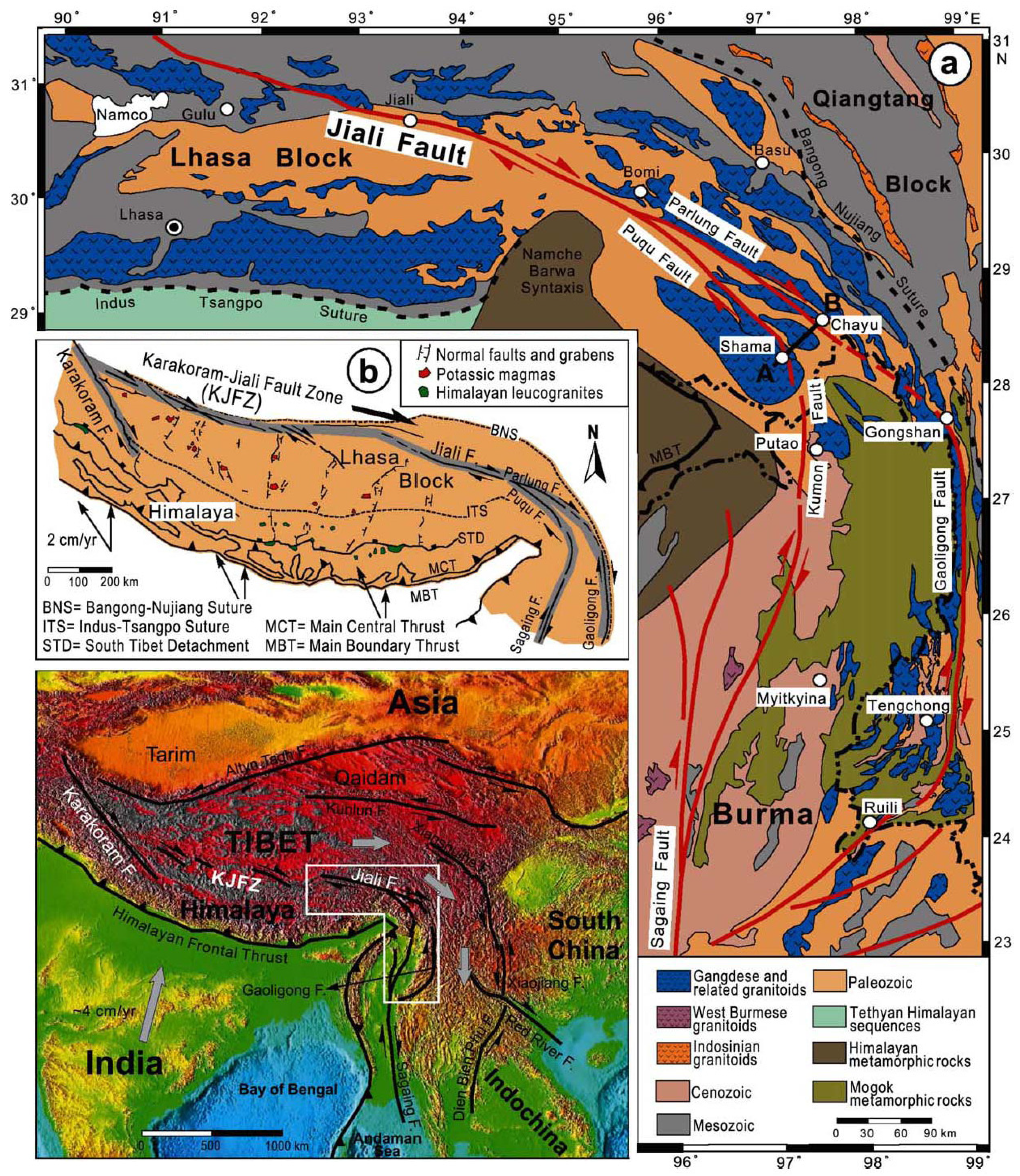
2.1. The Karakoram–Jiali Fault Zone in Southeastern Tibet


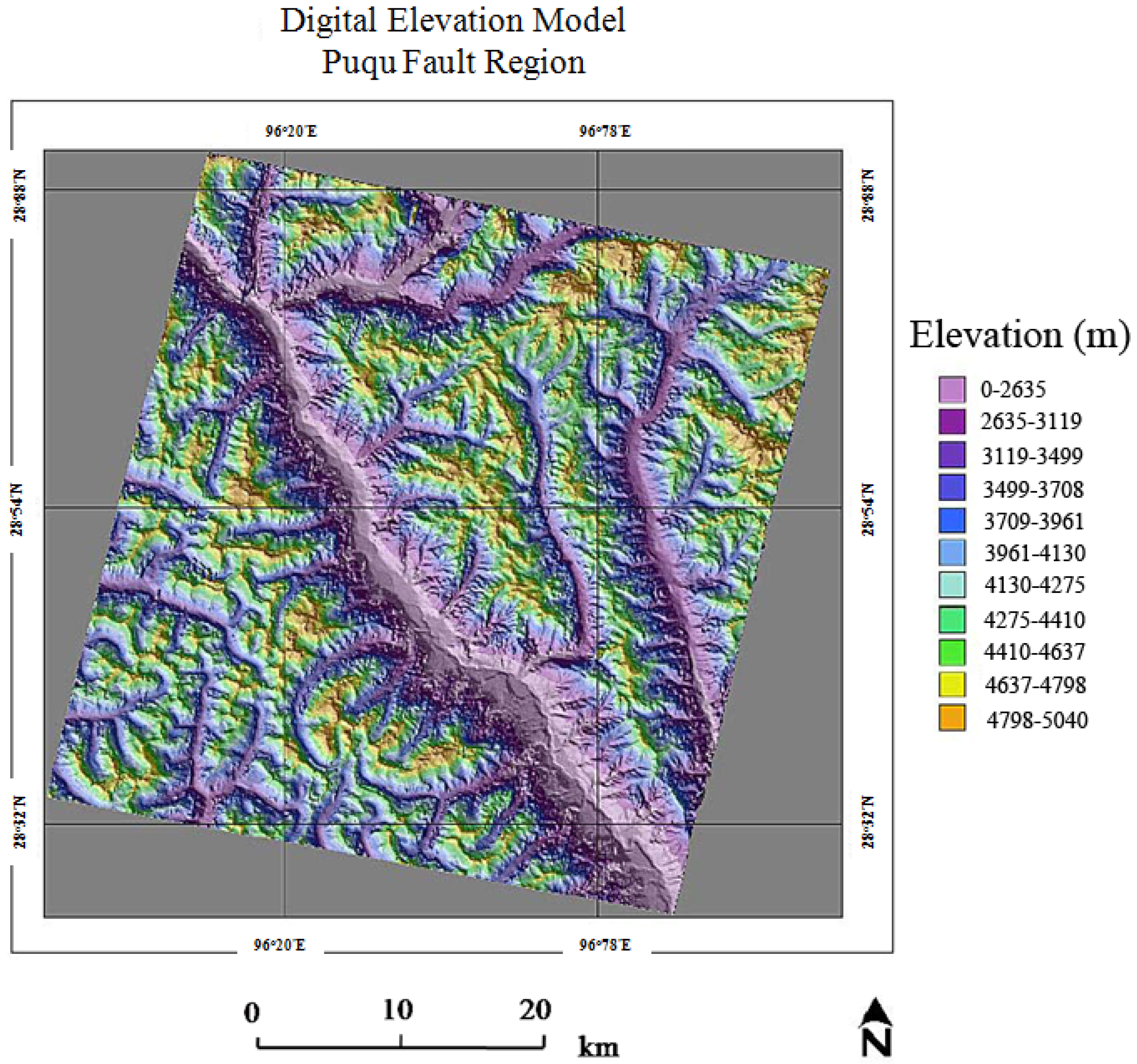
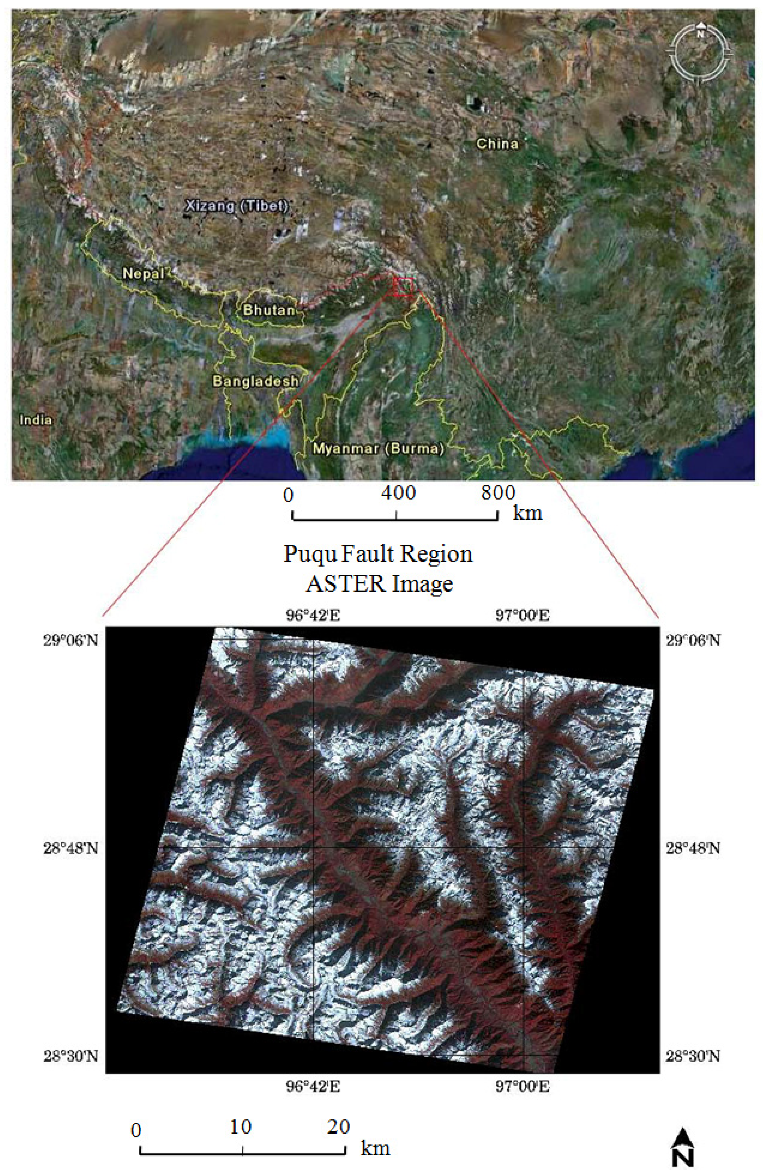
2.2. The Puqu Fault Region
3. Methodology and Results
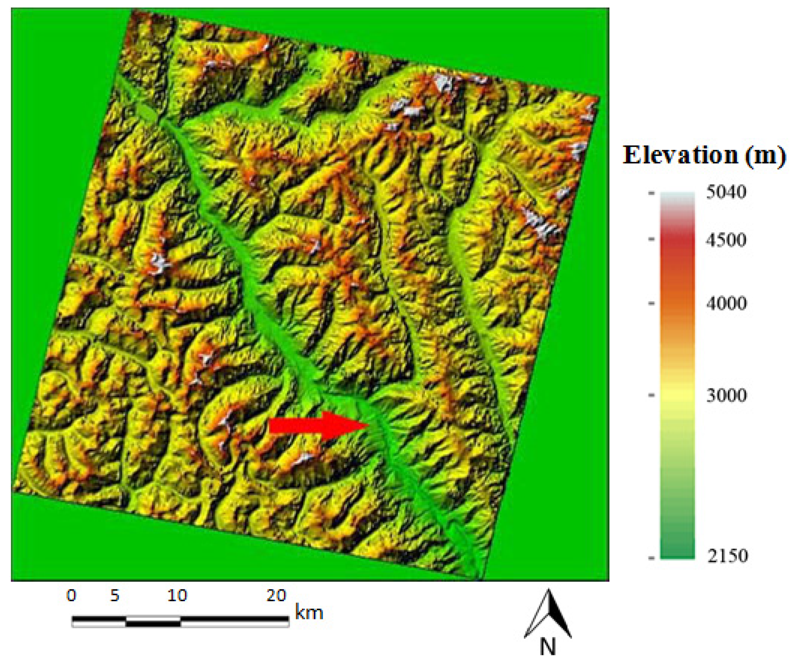
3.1. DEM Generation
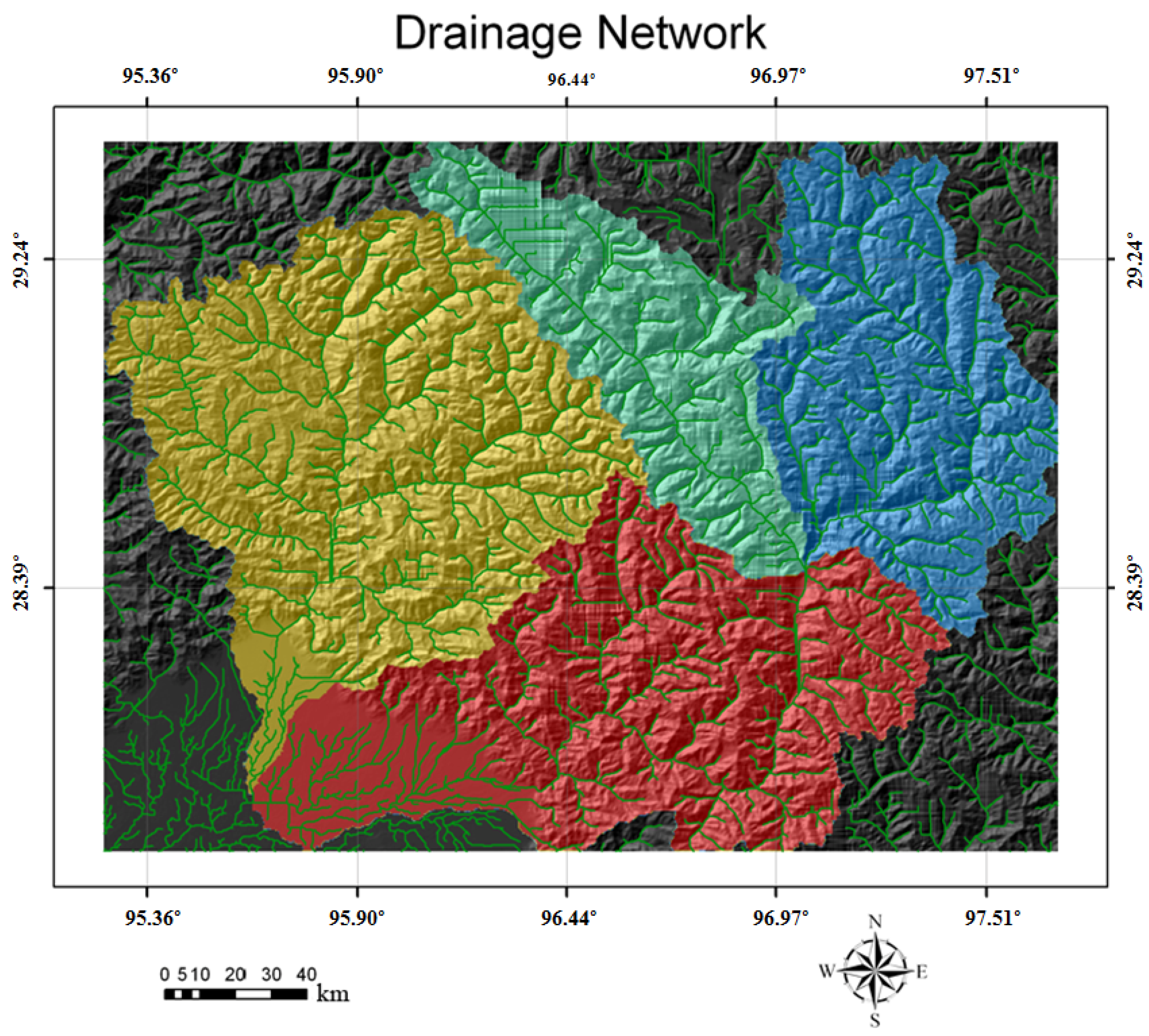
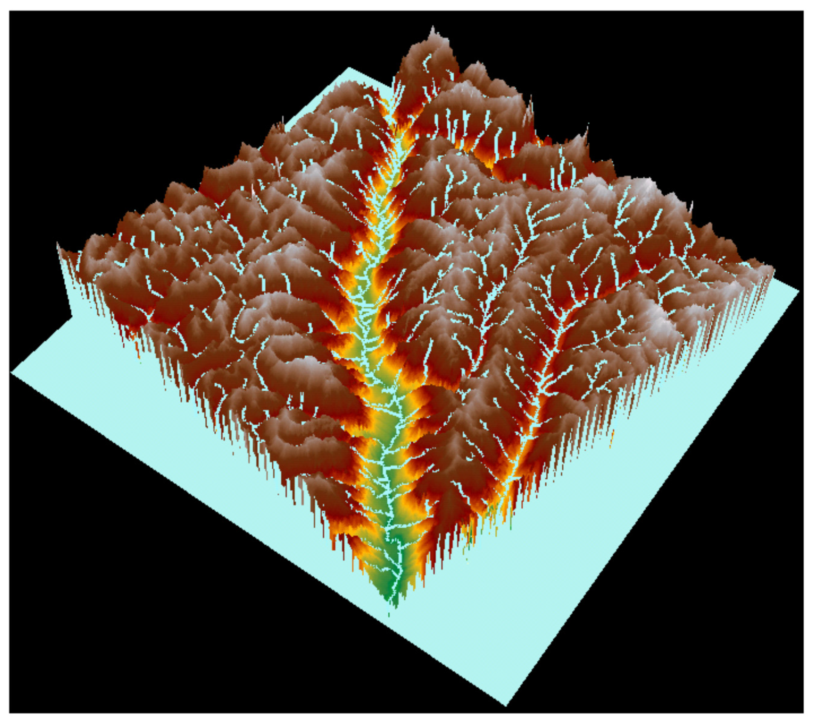
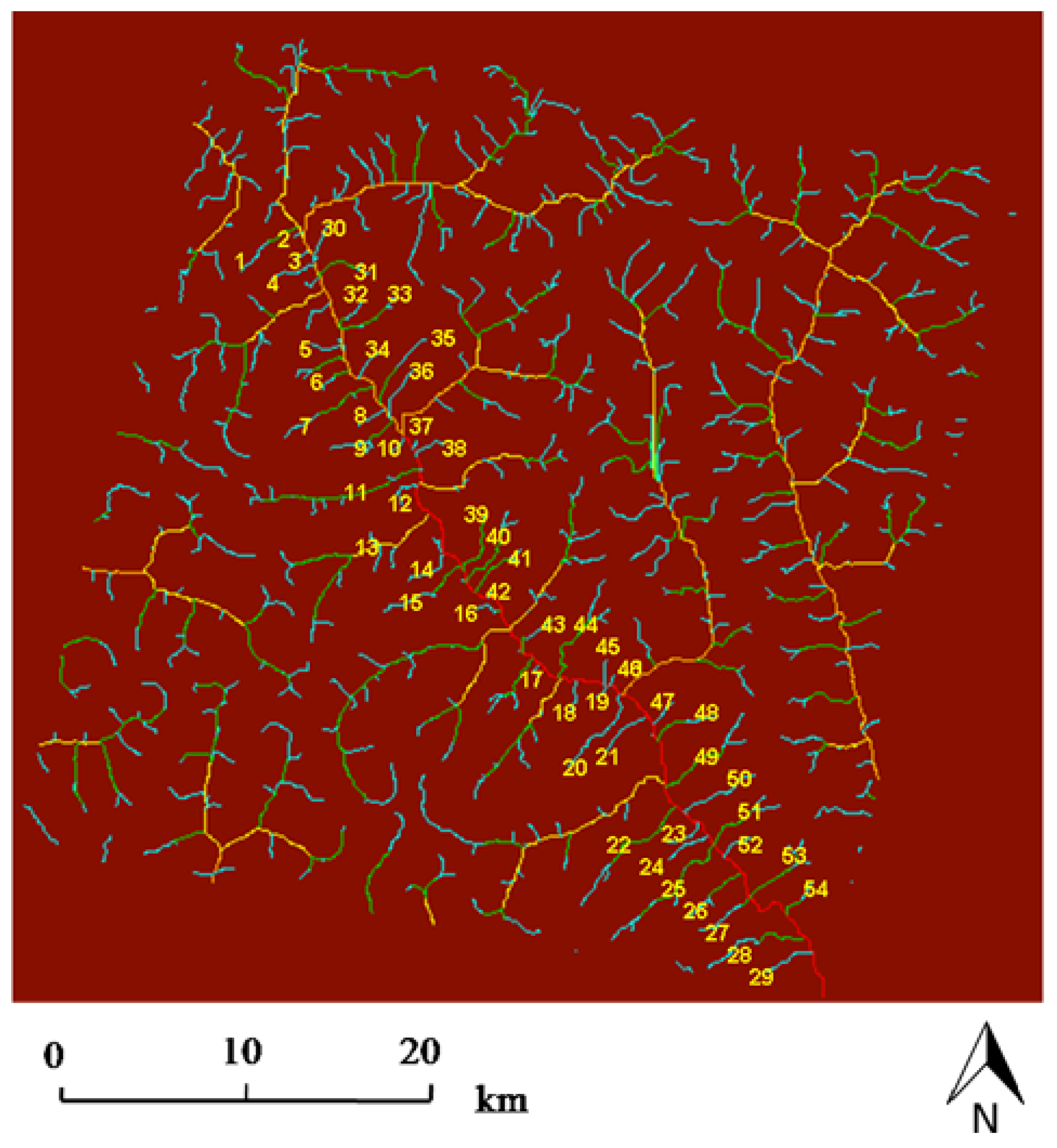
3.2. River Network Extraction


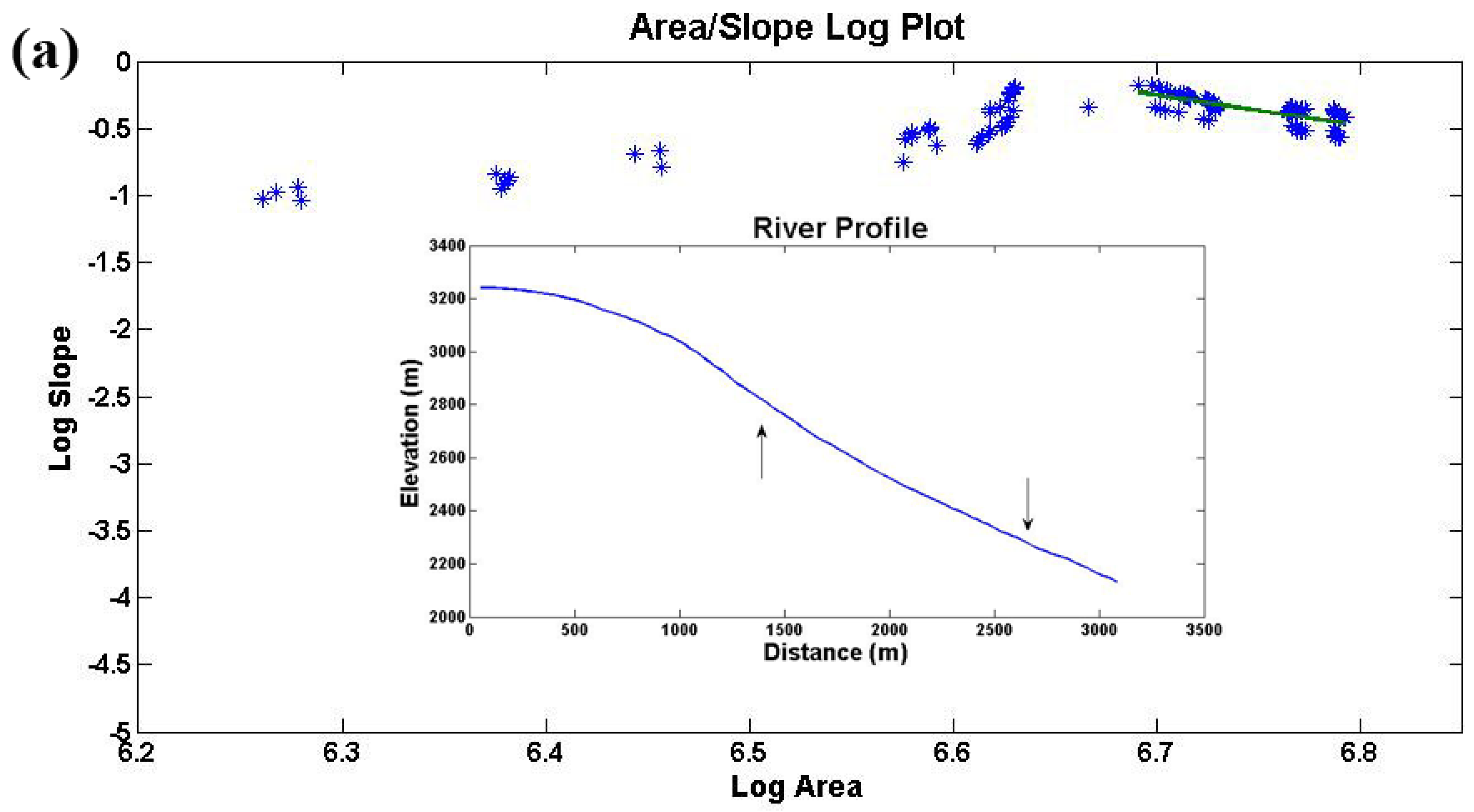
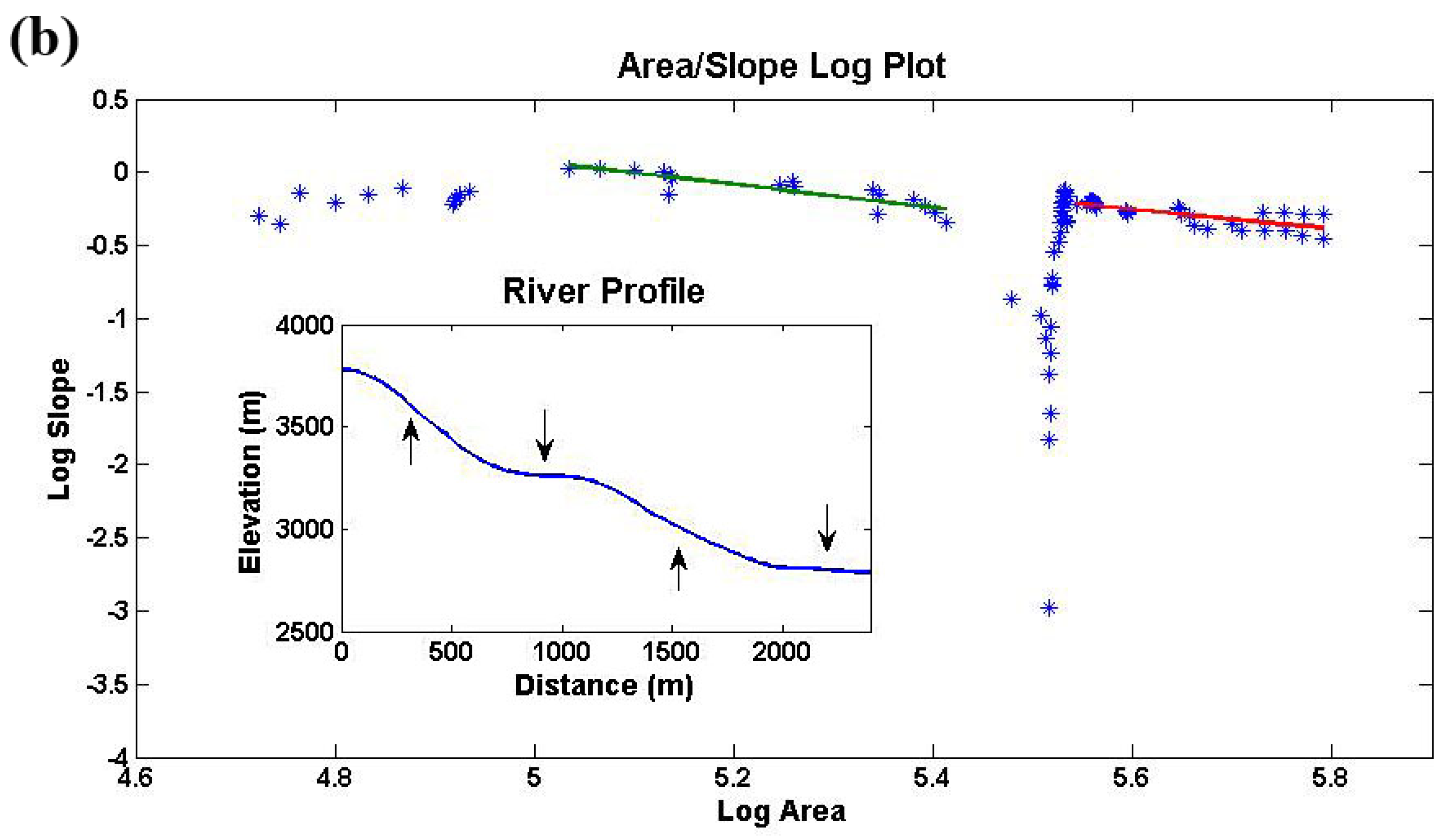
3.3. River Profile Analysis


| Stream | Lower Segment | Upper Segment | Lower Segment | Upper Segment | ||||
|---|---|---|---|---|---|---|---|---|
| Regression Fit | RMSE | Regression Fit | RMSE | θ | θ | |||
| 1 | y = 8.13 − 1.26x | 0.058 | y = 1.58 − 0.33x | 0.069 | 1.26 | 8.13 | 0.33 | 1.58 |
| 2 | y = 8.46 − 1.38x | 0.042 | y = 1.65 − 0.37x | 0.056 | 1.38 | 8.46 | 0.37 | 1.65 |
| 3 | y = 9.30 − 1.60x | 0.060 | y = 0.38 − 0.14x | 0.047 | 1.60 | 9.30 | 0.14 | 0.38 |
| 4 | y = 3.19 − 0.61x | 0.047 | y = 0.91 − 0.20x | 0.092 | 0.61 | 3.19 | 0.20 | 0.91 |
| 5 | y = 15.06 − 2.28x | 0.068 | - | - | 2.28 | 15.06 | - | - |
| 6 | y = 5.89 − 0.99x | 0.074 | y = 2.69 − 0.44x | 0.059 | 0.99 | 5.89 | 0.44 | 2.69 |
| 7 | y = 10.80 − 1.60x | 0.094 | y = 2.83 − 0.52x | 0.087 | 1.60 | 10.80 | 0.52 | 2.83 |
| 8 | y = 12.33 − 2.00x | 0.054 | - | - | 2.00 | 12.33 | - | - |
| 9 | y = 7.20 − 1.11x | 0.055 | - | - | 1.11 | 7.20 | - | - |
| 10 | y = 3.11 − 0.66x | 0.066 | - | - | 0.66 | 3.11 | - | - |
| 11 | y = 21.35 − 2.86x | 0.078 | y = 19.27 − 2.70x | 0.063 | 2.86 | 21.35 | 2.70 | 19.27 |
| 12 | y = 7.30 − 1.35x | 0.066 | - | - | 1.35 | 7.30 | - | - |
| 13* | N/A | - | N/A | - | N/A | - | N/A | - |
| 14 | y = 8.99 − 1.48x | 0.068 | - | - | 1.48 | 8.99 | - | - |
| 15 | y = 5.60 − 0.87x | 0.074 | - | - | 0.87 | 5.60 | - | - |
| 16 | y = 13.61 − 2.18x | 0.054 | y = 7.27 − 1.24x | 0.057 | 2.18 | 13.61 | 1.24 | 7.27 |
| 17 | y = 9.62 − 1.46x | 0.082 | y = 4.67 − 0.97x | 0.069 | 1.46 | 9.62 | 0.97 | 4.67 |
| 18 | y = 21.31 − 3.29x | 0.065 | y = 9.19 − 1.45x | 0.076 | 3.29 | 21.31 | 1.45 | 9.19 |
| 19 | y = 42.05 − 6.67x | 0.063 | - | - | 6.67 | 42.05 | - | - |
| 20 | y = 59.87 − 8.48x | 0.084 | y = 23.34 − 3.38x | 0.075 | 8.48 | 59.87 | 3.38 | 23.34 |
| 21 | y = 35.20 − 5.45x | 0.070 | y = 8.00 − 1.34x | 0.087 | 5.45 | 35.20 | 1.34 | 8.00 |
| 22 | y = 54.60 − 7.42x | 0.086 | - | - | 7.42 | 54.60 | - | - |
| 23 | y = 65.95 − 10.12x | 0.086 | y = 46.87 − 7.13x | 0.066 | 10.12 | 65.95 | 7.13 | 46.87 |
| 24 | y = 46.20 − 7.15x | 0.068 | y = 20.73 − 3.24x | 0.081 | 7.15 | 46.20 | 3.24 | 20.73 |
| 25 | y = 55.67 − 7.50x | 0.093 | y = 12.22 − 1.76x | 0.080 | 7.50 | 55.67 | 1.76 | 12.22 |
| 26 | y = 35.92 − 5.38x | 0.089 | y = 10.02 − 1.92x | 0.075 | 5.38 | 35.92 | 1.92 | 10.02 |
| 27 | y = 29.86 − 4.44x | 0.060 | y = 7.49 − 1.16x | 0.069 | 4.44 | 29.86 | 1.16 | 7.49 |
| 28 | y = 20.62 − 3.00x | 0.075 | y = 15.65 − 2.31x | 0.057 | 3.00 | 20.62 | 2.31 | 15.65 |
| 29* | N/A | - | N/A | - | N/A | - | N/A | - |
| 30* | N/A | - | N/A | - | N/A | - | N/A | - |
| 31 | y = 19.36 − 2.81x | 0.068 | - | - | 2.81 | 19.36 | - | - |
| 32* | N/A | - | N/A | - | N/A | - | N/A | - |
| 33 | y = 21.42 − 3.14x | 0.059 | y = 0.55 − 0.16x | 0.065 | 3.14 | 21.42 | 0.16 | 0.55 |
| 34 | y = 20.19 − 3.34x | 0.089 | y = 10.02 − 1.92x | 0.075 | 3.34 | 20.19 | 1.92 | 10.02 |
| 35 | y = 10.93 − 1.63x | 0.069 | y = 4.72 − 0.75x | 0.060 | 1.63 | 10.93 | 0.75 | 4.72 |
| 36 | y = 4.34 − 0.74x | 0.091 | y = 0.66 − 0.14x | 0.082 | 0.74 | 4.34 | 0.14 | 0.66 |
| 37 | y = 8.37 − 1.38x | 0.071 | y = 0.10 − 0.05x | 0.074 | 1.38 | 8.37 | 0.05 | 0.10 |
| 38 | y = 9.30 − 1.45x | 0.057 | y = 3.77 − 0.67x | 0.076 | 1.45 | 9.30 | 0.67 | 3.77 |
| 39 | y = 21.25 − 3.29x | 0.081 | y = 4.84 − 0.84x | 0.079 | 3.29 | 21.25 | 0.84 | 4.84 |
| 40 | y = 27.44 − 3.92x | 0.091 | y = 3.37 − 0.57x | 0.012 | 3.92 | 27.44 | 0.57 | 3.37 |
| 41 | y = 33.15 − 4.89x | 0.073 | y = 21.59 − 3.25x | 0.071 | 4.89 | 33.15 | 3.25 | 21.59 |
| 42 | y = 17.15 − 2.99x | 0.068 | - | - | 2.99 | 17.15 | - | - |
| 43 | y = 6.10 − 1.05x | 0.066 | y = 0.63 − 0.14x | 0.076 | 1.05 | 6.10 | 0.14 | 0.63 |
| 44 | y = 12.09 − 1.74x | 0.061 | y = 11.35 − 1.74x | 0.075 | 1.74 | 12.09 | 1.74 | 11.35 |
| 45 | y = 6.10 − 1.03x | 0.072 | - | - | 1.03 | 6.10 | - | - |
| 46* | N/A | - | N/A | - | N/A | - | N/A | - |
| 47 | y = 31.84 − 5.13x | 0.076 | y = 1.88 − 0.35x | 0.070 | 5.13 | 31.84 | 0.35 | 1.88 |
| 48 | y = 43.41 − 6.60x | 0.083 | - | - | 6.60 | 43.41 | - | - |
| 49 | y = 54.32 − 7.52x | 0.072 | - | - | 7.52 | 54.32 | - | - |
| 50 | y = 71.67 − 10.21x | 0.082 | y = 21.98 − 3.25x | 0.067 | 10.21 | 71.67 | 3.25 | 21.98 |
| 51 | y = 29.29 − 4.17x | 0.081 | - | - | 4.17 | 29.29 | - | - |
| 52* | N/A | - | N/A | - | N/A | - | N/A | - |
| 53 | y = 24.61 − 3.55x | 0.077 | y = 28.94 − 4.17x | 0.076 | 3.55 | 24.61 | 4.17 | 28.94 |
| 54 | y = 40.46 − 6.19x | 0.071 | - | - | 6.19 | 40.46 | - | - |

4. Discussion
4.1. Channel Equilibrium Hypothesis
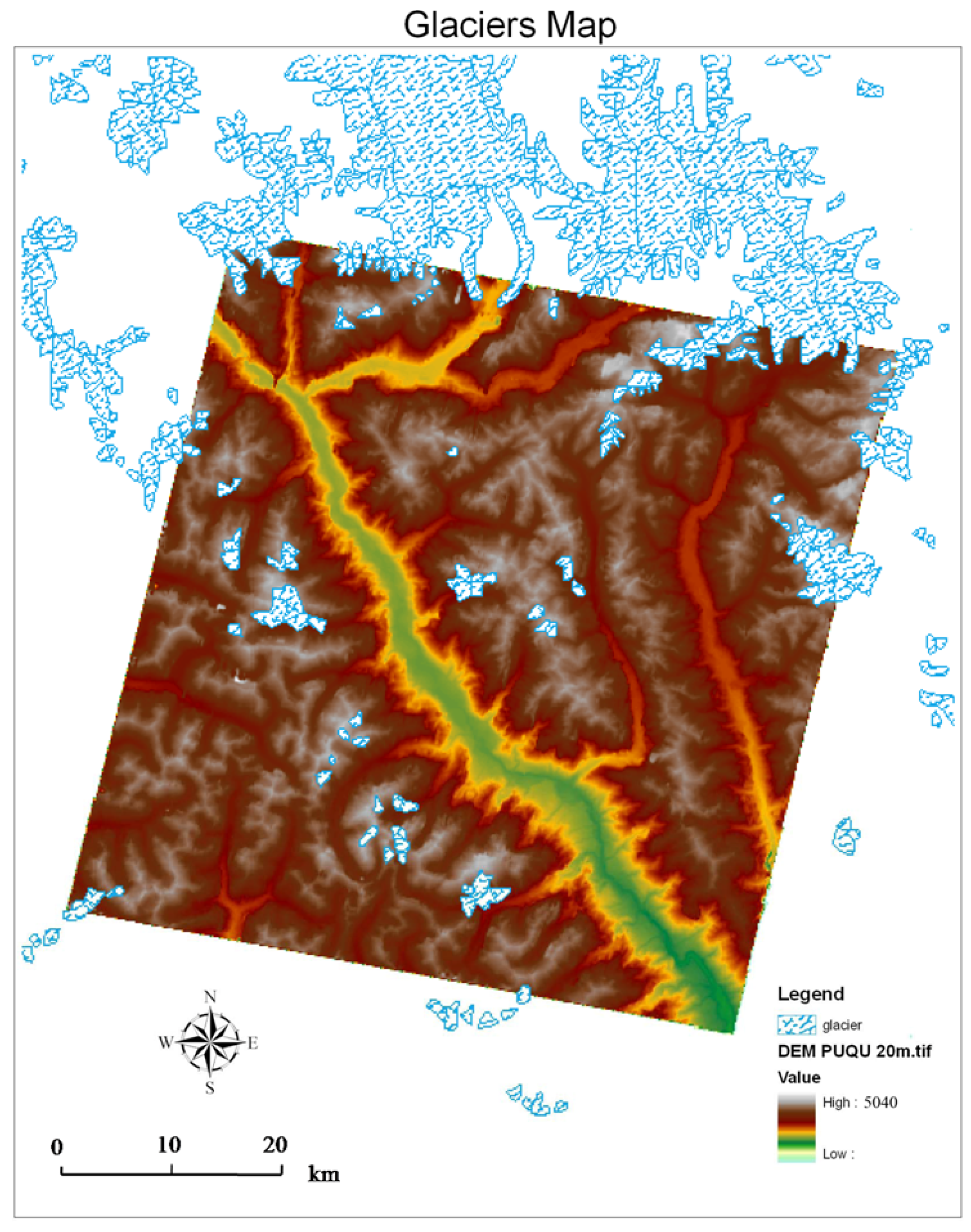
4.2. Potential Effects of Glaciations

4.3. Open Questions
5. Conclusions
Acknowledgments
Author Contributions
Conflicts of Interest
References
- Wobus, C.; Whipple, K.X.; Kirby, E.; Snyder, N.; Johnson, J.; Spyropolou, K.; Crosby, B.; Sheehan, D. Tectonics from topography: Procedures, promise, and pitfalls. Geol. Soc. Am. Spec. Papers 2006, 398, 55–74. [Google Scholar]
- Gregory, K.M.; Chase, C.G. Tectonic and climatic significance of a late Eocene low-relief, high-level geomorphic surface, Colorado. J. Geophys. Res. Solid Earth (1978–2012) 1994, 99, 20141–20160. [Google Scholar] [CrossRef]
- Clark, M.K.; Royden, L.H. Topographic ooze: Building the eastern margin of tibet by lower crustal flow. Geology 2000, 28, 703–706. [Google Scholar] [CrossRef]
- Schoenbohm, L.; Whipple, K.; Burchfiel, B.; Chen, L. Geomorphic constraints on surface uplift, exhumation, and plateau growth in the Red River region, Yunnan province, China. Geol. Soc. Am. Bull. 2004, 116, 895–909. [Google Scholar] [CrossRef]
- Burbank, D.W.; Leland, J.; Fielding, E.; Anderson, R.S.; Brozovic, N.; Reid, M.R.; Duncan, C. Bedrock incision, rock uplift and threshold hillslopes in the northwestern himalayas. Nature 1996, 379, 505–510. [Google Scholar] [CrossRef]
- Heimsath, A.M.; Dietrich, W.E.; Nishiizumi, K.; Finkel, R.C. The soil production function and landscape equilibrium. Nature 1997, 388, 358–361. [Google Scholar] [CrossRef]
- Montgomery, D.R.; Brandon, M.T. Topographic controls on erosion rates in tectonically active mountain ranges. Earth Planet Sci. Lett. 2002, 201, 481–489. [Google Scholar] [CrossRef]
- Larue, J.-P. Effects of tectonics and lithology on long profiles of 16 rivers of the southern Central Massif border between the Aude and the Orb (France). Geomorphology 2008, 93, 343–367. [Google Scholar] [CrossRef]
- Larue, J.-P. Tectonic influences on the quaternary drainage evolution on the north-western margin of the French Central Massif: The creuse valley example. Geomorphology 2008, 93, 398–420. [Google Scholar] [CrossRef]
- Ambili, V.; Narayana, A. Tectonic effects on the longitudinal profiles of the chaliyar river and its tributaries, Southwest India. Geomorphology 2014, 217, 37–47. [Google Scholar] [CrossRef]
- VanLaningham, S.; Meigs, A.; Goldfinger, C. The effects of rock uplift and rock resistance on river morphology in a subduction zone forearc, Oregon, USA. Earth Surf. Process. Landf. 2006, 31, 1257–1279. [Google Scholar] [CrossRef]
- Peters, G.; van Balen, R.T. Pleistocene tectonics inferred from fluvial terraces of the northern Upper Rhine Graben, Germany. Tectonophysics 2007, 430, 41–65. [Google Scholar] [CrossRef]
- Gloaguen, R.; Kabner, A.; Wobbe, F.; Shahzad, F.; Mahmood, A. Remote sensing analysis of crustal deformation using river networks. In Proceedings of the IEEE International Geoscience and Remote Sensing Symposium, 2008, IGARSS 2008, Boston, MA, USA, 7–11 July 2008; pp. IV-1–IV-4.
- Shahzad, F.; Mahmood, S.A.; Gloaguen, R. Drainage network and lineament analysis: An approach for Potwar Plateau (Northern Pakistan). J. Mt. Sci. 2009, 6, 14–24. [Google Scholar] [CrossRef]
- Leeder, M.; Jackson, J. The interaction between normal faulting and drainage in active extensional basins, with examples from the Western United States and Central Greece. Basin Res. 1993, 5, 79–102. [Google Scholar] [CrossRef]
- Schumm, S.A.; Schumm, S.A.; Dumont, J.F.; Holbrook, J.M. Active Tectonics and Alluvial Rivers; Cambridge University Press: Cambridge, UK, 2002. [Google Scholar]
- Hack, J.T. Stream-profile analysis and stream-gradient index. J. Res. US Geol. Surv. 1973, 1, 421–429. [Google Scholar]
- Howard, A.D.; Kerby, G. Channel changes in badlands. Geol. Soc. Am. Bull. 1983, 94, 739–752. [Google Scholar] [CrossRef]
- Snyder, N.P.; Whipple, K.X.; Tucker, G.E.; Merritts, D.J. Landscape response to tectonic forcing: Digital elevation model analysis of stream profiles in the mendocino triple junction region, northern california. Geol. Soc. Am. Bull. 2000, 112, 1250–1263. [Google Scholar] [CrossRef]
- Lague, D.; Davy, P.; Crave, A. Estimating uplift rate and erodibility from the area-slope relationship: Examples from Brittany (France) and numerical modelling. Phys. Chem. Earth A Solid Earth Geod. 2000, 25, 543–548. [Google Scholar] [CrossRef]
- Kirby, E.; Whipple, K. Quantifying differential rock-uplift rates via stream profile analysis. Geology 2001, 29, 415–418. [Google Scholar] [CrossRef]
- Shahzad, F.; Gloaguen, R. Tecdem: A matlab based toolbox for tectonic geomorphology, part 1: Drainage network preprocessing and stream profile analysis. Comput. Geosci. 2011, 37, 250–260. [Google Scholar] [CrossRef]
- Anoop, A.; Prasad, S.; Basavaiah, N.; Brauer, A.; Shahzad, F.; Deenadayalan, K. Tectonic versus climate influence on landscape evolution: A case study from the upper Spiti Valley, NWHimalaya. Geomorphology 2012, 145, 32–44. [Google Scholar] [CrossRef]
- Fuchs, M.C.; Gloaguen, R.; Pohl, E. Tectonic and climatic forcing on the Panj river system during the Quaternary. Int. J. Earth Sci. 2013, 102, 1985–2003. [Google Scholar] [CrossRef]
- Kirby, E.; Whipple, K.X. Expression of active tectonics in erosional landscapes. J. Struct. Geol. 2012, 44, 54–75. [Google Scholar] [CrossRef]
- Mahmood, S.A.; Gloaguen, R. Appraisal of active tectonics in hindu kush: Insights from DEM derived geomorphic indices and drainage analysis. Geosci. Front. 2012, 3, 407–428. [Google Scholar] [CrossRef]
- Vezzoli, G.; Garzanti, E.; Vincent, S.J.; Andò, S.; Carter, A.; Resentini, A. Tracking sediment provenance and erosional evolution of the western greater caucasus. Earth Surf. Process. Landf. 2014, 39, 1101–1114. [Google Scholar] [CrossRef]
- Florinsky, I.; Eilers, R.G.; Manning, G.; Fuller, L. Prediction of soil properties by digital terrain modelling. Environ. Model. Softw. 2002, 17, 295–311. [Google Scholar] [CrossRef]
- Lindsay, J.B. The terrain analysis system: A tool for hydro-geomorphic applications. Hydrol. Process. 2005, 19, 1123–1130. [Google Scholar] [CrossRef]
- Foster, M.A.; Kelsey, H.M. Knickpoint and knickzone formation and propagation, South Fork Eel River, northern California. Geosphere 2012, 8, 403–416. [Google Scholar] [CrossRef]
- Whipple, K.X.; Tucker, G.E. Dynamics of the stream-power river incision model: Implications for height limits of mountain ranges, landscape response timescales, and research needs. J. Geophys. Res. Solid Earth (1978–2012) 1999, 104, 17661–17674. [Google Scholar] [CrossRef]
- Booth, A.L.; Zeitler, P.K.; Kidd, W.S.; Wooden, J.; Liu, Y.; Idleman, B.; Hren, M.; Chamberlain, C.P. U-Pb zircon constraints on the tectonic evolution of Southeastern Tibet, Namche Barwa area. Am. J. Sci. 2004, 304, 889–929. [Google Scholar] [CrossRef]
- Murphy, M.; Yin, A.; Harrison, T.; Dürr, S.; Chen, Z.; Ryerson, F.; Kidd, W.; Wang, X.; Zhou, X. Did the Indo-Asian collision alone create the Tibetan plateau? Geology 1997, 25, 719–722. [Google Scholar] [CrossRef]
- Yin, A.; Harrison, T.M. Geologic evolution of the Himalayan-Tibetan Orogen. Ann. Rev. Earth Planet. Sci. 2000, 28, 211–280. [Google Scholar] [CrossRef]
- Kapp, P.; Murphy, M.A.; Yin, A.; Harrison, T.M.; Ding, L.; Guo, J. Mesozoic and cenozoic tectonic evolution of the shiquanhe area of Western Tibet. Tectonics 2003, 22. [Google Scholar] [CrossRef]
- Lee, H.-Y.; Chung, S.-L.; Wang, J.-R.; Wen, D.-J.; Lo, C.-H.; Yang, T.F.; Zhang, Y.; Xie, Y.; Lee, T.-Y.; Wu, G. Miocene Jiali Faulting and its implications for Tibetan tectonic evolution. Earth Planet. Sci. Lett. 2003, 205, 185–194. [Google Scholar] [CrossRef]
- Tapponnier, P.; Zhiqin, X.; Roger, F.; Meyer, B.; Arnaud, N.; Wittlinger, G.; Jingsui, Y. Oblique stepwise rise and growth of the Tibet Plateau. Science 2001, 294, 1671–1677. [Google Scholar] [CrossRef] [PubMed]
- Wang, Q.; Zhang, P.-Z.; Freymueller, J.T.; Bilham, R.; Larson, K.M.; Lai, X.a.; You, X.; Niu, Z.; Wu, J.; Li, Y. Present-day crustal deformation in china constrained by global positioning system measurements. Science 2001, 294, 574–577. [Google Scholar] [CrossRef] [PubMed]
- Chung, L.; Yang, T.; Chung, S.; Liu, T.; Walia, M.; Lo, C. Fission track ages as evidence for the thermal history of Jiali Fault (Eastern Tibet) and its tectonic implications. In Proceedings of AGU Fall Meeting, San Francisco, CA, USA, 11–15 December 2006; p. 1577.
- Searle, M.; Elliott, J.; Phillips, R.; Chung, S.-L. Crustal-lithospheric structure and continental extrusion of tibet. J. Geol. Soc. 2011, 168, 633–672. [Google Scholar] [CrossRef]
- Peltzer, G.; Tapponnier, P. Formation and evolution of strike-slip faults, rifts, and basins during the India-Asia collision: An experimental approach. J. Geophys. Res. Solid Earth (1978–2012) 1988, 93, 15085–15117. [Google Scholar] [CrossRef]
- Replumaz, A.; Tapponnier, P. Reconstruction of the deformed collision zone between India and Asia by backward motion of lithospheric blocks. J. Geophys. Res. Solid Earth (1978–2012) 2003, 108. [Google Scholar] [CrossRef]
- Song, S.; Niu, Y.; Wei, C.; Ji, J.; Su, L. Metamorphism, anatexis, zircon ages and tectonic evolution of the gongshan block in the northern indochina continent—An eastern extension of the lhasa block. Lithos 2010, 120, 327–346. [Google Scholar] [CrossRef]
- O'Callaghan, J.F.; Mark, D.M. The extraction of drainage networks from digital elevation data. Comput.Vis. Graph. Image Process. 1984, 28, 323–344. [Google Scholar] [CrossRef]
- Howard, A.D. A detachment-limited model of drainage basin evolution. Water Resour. Res. 1994, 30, 2261–2285. [Google Scholar] [CrossRef]
- Whipple, K.X.; Hancock, G.S.; Anderson, R.S. River incision into bedrock: Mechanics and relative efficacy of plucking, abrasion, and cavitation. Geol. Soc. Am. Bull. 2000, 112, 490–503. [Google Scholar] [CrossRef]
- Seidl, M.; Dietrich, W. The problem of channel erosion into bedrock. Catena Suppl. 1993, 23, 101–101. [Google Scholar]
- Spicer, R.A.; Harris, N.B.; Widdowson, M.; Herman, A.B.; Guo, S.; Valdes, P.J.; Wolfe, J.A.; Kelley, S.P. Constant elevation of southern tibet over the past 15 million years. Nature 2003, 421, 622–624. [Google Scholar] [CrossRef] [PubMed]
- Dewey, J.F.; Shackleton, R.M.; Chengfa, C.; Yiyin, S. The tectonic evolution of the Tibetan Plateau. Philos. Trans. R. Soc. Lond. Ser. A Math. Phys. Sci. 1988, 327, 379–413. [Google Scholar] [CrossRef]
- Harrison, T.M.; Copeland, P.; Hall, S.A.; Quade, j.; Burner, S.; Ojha, T.P.; Kidd, W. Isotopic preservation of Himalayan/Tibetan uplift, denudation, and climatic histories of two molasse deposits. J. Geol. 1993, 101, 157–175. [Google Scholar] [CrossRef]
- Kirby, E.; Whipple, K.X.; Tang, W.; Chen, Z. Distribution of active rock uplift along the eastern margin of the Tibetan Plateau: Inferences from bedrock channel longitudinal profiles. J. Geophys. Res. Solid Earth (1978–2012) 2003, 108. [Google Scholar] [CrossRef]
- Whipple, K.X. Fluvial landscape response time: How plausible is steady-state denudation? Am. J. Sci. 2001, 301, 313–325. [Google Scholar] [CrossRef]
- Hobley, D.E.; Sinclair, H.D.; Cowie, P.A. Processes, rates, and time scales of fluvial response in an ancient postglacial landscape of the Northwest Indian Himalaya. Geol. Soc. Am. Bull. 2010, 122, 1569–1584. [Google Scholar] [CrossRef]
- Wu, L.; Li, X. China Glacier Information System; Ocean Press: Beijing, China, 2004; p. 135. (In Chinese) [Google Scholar]
- Farrand, W.R. Postglacial uplift in north america. Am. J. Sci. 1962, 260, 181–199. [Google Scholar] [CrossRef]
- Andrews, J. Postglacial rebound in arctic canada: Similarity and prediction of uplift curves. Can. J. Earth Sci. 1968, 5, 39–47. [Google Scholar] [CrossRef]
- Kuhle, M. Glacial isostatic uplift of Tibet as a consequence of a former ice sheet. Geo J. 1995, 37, 431–449. [Google Scholar]
- Harris, N. The elevation history of the Tibetan Plateau and its implications for the Asian monsoon. Palaeogeogr. Palaeoclimatol. Palaeoecol. 2006, 241, 4–15. [Google Scholar] [CrossRef]
- Lautenschlager, M.; Santer, B.D. Atmospheric response to a hypothetical tibetan ice sheet. J. Clim. 1991, 4, 386–394. [Google Scholar] [CrossRef]
- Kirby, E.; Ouimet, W. Tectonic geomorphology along the eastern margin of tibet: Insights into the pattern and processes of active deformation adjacent to the sichuan basin. Geol. Soc. Lond. Spec. Publ. 2011, 353, 165–188. [Google Scholar] [CrossRef]
- Regalla, C.; Kirby, E.; Fisher, D.; Bierman, P. Active forearc shortening in Tohoku, Japan: Constraints on fault geometry from erosion rates and fluvial longitudinal profiles. Geomorphology 2013, 195, 84–98. [Google Scholar] [CrossRef]
© 2015 by the authors; licensee MDPI, Basel, Switzerland. This article is an open access article distributed under the terms and conditions of the Creative Commons Attribution license (http://creativecommons.org/licenses/by/4.0/).
Share and Cite
Lu, P.; Shang, Y. Active Tectonics Revealed by River Profiles along the Puqu Fault. Water 2015, 7, 1628-1648. https://doi.org/10.3390/w7041628
Lu P, Shang Y. Active Tectonics Revealed by River Profiles along the Puqu Fault. Water. 2015; 7(4):1628-1648. https://doi.org/10.3390/w7041628
Chicago/Turabian StyleLu, Ping, and Yu Shang. 2015. "Active Tectonics Revealed by River Profiles along the Puqu Fault" Water 7, no. 4: 1628-1648. https://doi.org/10.3390/w7041628
APA StyleLu, P., & Shang, Y. (2015). Active Tectonics Revealed by River Profiles along the Puqu Fault. Water, 7(4), 1628-1648. https://doi.org/10.3390/w7041628