3.1. The Territorial Context: The Estuary of the Guadalquivir
All public major construction projects should be based on a comprehensive and wide-ranging knowledge of the territorial context, as the environmental and socioeconomic impact of these works goes well beyond their immediate area of influence. In the specific case of the MAM, both the promoters of the project (Seville Harbour Authority) as well as other supporting institutions (Cámara de Comercio de Sevilla, Ayuntamiento de Sevilla, Confederación de Empresarios de Sevilla) estimated its benefits within a limited local context [
31,
32]. However, such a narrow focus ignored the real impact of the project, which should have been assessed for a much wider context: the whole estuary. The estuary of the Guadalquivir comprises the lower course of the river (approximately 90 km long) and an area of approximately 1800 km
2. Apart from its rich natural and cultural heritage, the estuary is a key economic factor for the provinces of Cadiz, Huelva and Seville, which are inhabited by over 1.5 million people.
Throughout history, the availability of good agricultural land and plentiful water in the lowest course of the Guadalquivir has been one of the region’s key economic assets. However, recent technological developments and the proliferation of infrastructures have increasingly forced the estuary to adapt to the needs of different and competing productive activities; unfortunately, this process has lacked coordination and a clear direction. As a consequence of both human intervention and the uncoordinated management of resources the estuary is in critical condition. This is one of the main conclusions of the scientific study entitled “Methodological proposal to diagnose and forecast the consequences of human activities in the estuary of the Guadalquivir” [
21].
Currently, uncoordinated action remains the norm. As a result, a patchwork of different water activities, with their respective sectorial regulations, converges in the lower course of the river.
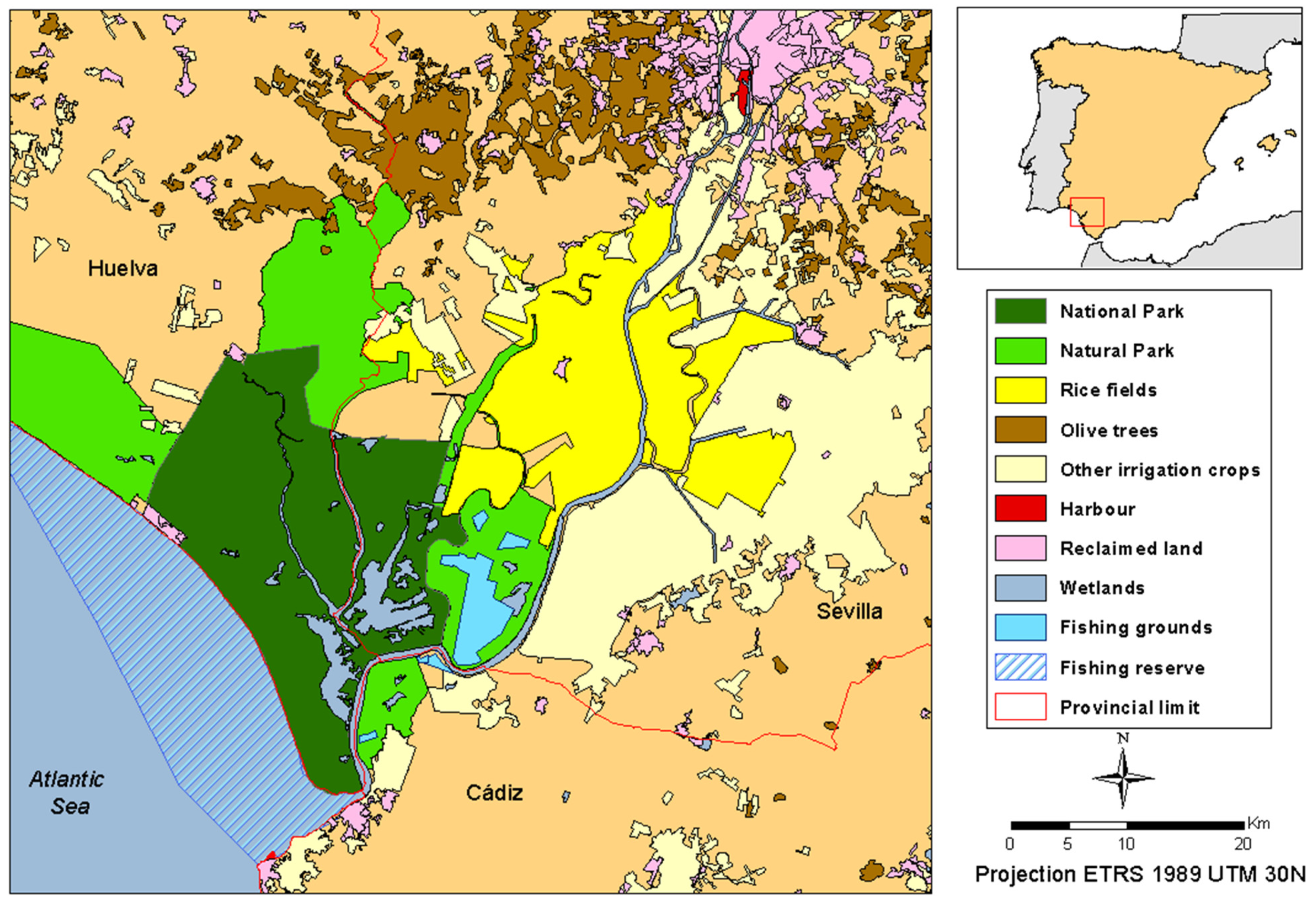
Figure 1 reproduces a map of water use.
Figure 1.
Main water uses in the lower Guadalquivir valley.
Figure 1.
Main water uses in the lower Guadalquivir valley.
River and sea commerce have a long tradition in the harbour of Seville, most significantly during the period in which the city hosted the Casa de Contratación (founded in 1580) and held the commercial monopoly between Spain and the Spanish American colonies, when the city played a key role in the configuration of the Hispanic Monarchy. In the 17th century, the initial advantages of the inland location of the harbour—reduced land-transport costs, and administrative and military security—were more than overcome by the disadvantages, essentially the increasingly difficult access of ever-larger ships over the growing sandbar in Sanlucar, which resulted in a shallower and narrower navigable channel [
33,
34]. These problems—aside from other political and economic reasons behind the crisis of the Spanish Empire—caused the Casa de la Contratación to relocate to Cadiz in 1717. At that point, Sevillan voices started proposing solutions based on the modification of the natural conditions of the river [
33]. From the 18th century onwards, therefore, the river was subject to major human alterations which aimed to preserve the navigability of the river as far as Seville. These works essentially consisted of the artificial cutting off of river meanders and the configuration of a straighter course. During these works, the length of the lower course, which was originally approximately 120 km, was reduced to 90 km. In addition, over the last few decades, annual maintenance dredging works have been carried out in order to maintain the necessary conditions of navigability. Currently, the MAM reproduces the historical problem posed by the advantages (inland location) and disadvantages (poor conditions for navigation along the estuary) of the inland location of Seville’s harbour. On the one hand, it tries to exploit the port’s historical and geographical connections with the Atlantic and the metropolitan area of Madrid [
35], but, on the other hand, the navigability conditions are insufficient for large ships, as the very name of the project seems to admit.
The large infrastructures built alongside its course bear witness to the importance of the harbour of Seville. Historically, the port has had the last word on any project which could have an impact on the river, with the preservation of navigability as the main, concern [
33] This issue is still of paramount importance in the management of the water resources of the lower Guadalquivir, and is indeed key in the MAM-related controversy, because of the project’s potential impact on the remaining uses of water in the area of influence of the estuary of the Guadalquivir.
As previously noted, from the mid-18th century onwards, the lower Guadalquivir River underwent a radical transformation which involved the construction of large-scale infrastructures—draining of marshes, construction of dikes and dams, and stabilization of banks—and the progressive colonization of the riverside areas, resulting in the current situation, in which multiple uses compete for space and resources [
33,
34,
35,
36]. In this regard, the river in its current state cannot be understood other than as the result of a complex evolutional interplay of social, economic and natural forces around the role of water. The territory around the lower Guadalquivir revolves around water, and any action that may compromise its availability is, inevitably, a source of conflict.
Until the 20th century, traditional fishing practices were the main economic activity for most riverside communities [
37]. The general wholesomeness of estuary water and the exchange of material between the fresh water mass and the sea contribute to a nutrient-rich lower river course, which results in a high degree of biodiversity and plentiful fishing resources. However, the priority given to other uses, such as navigability and agriculture, in addition to unrestricted fishing, ultimately resulted in the overexploitation of resources, the alteration of habitats and the disappearance of some of the Guadalquivir’s most emblematic fish species, for example sturgeon. Today, fishing within the lowest 16 km of the river course (Reserva de Pesca del Bajo Guadalquivir) is strictly regulated; this protected area is of paramount importance for the reproduction of the species that inhabit the Gulf of Cadiz [
37].
Currently, “There have been cataloged more than 80 species of fish. This biological wealth is so high that it has been considered a hot spot of biodiversity Andalusia. Probably no other area of Andalusia possesses an aquatic community as rich and diverse as that found in the past forty kilometers from the main channel of the Guadalquivir” [
38].
During the 20th century, the previously discussed hydraulic paradigm fostered the pre-eminence of agricultural uses, especially the cultivation of rice in the Guadalquivir marshes, which are “enormous plains which are periodically flooded by the river, where cultivation in the ideal irrigation and temperature conditions may be undertaken” [
36]. As they were traditionally regarded as an inhospitable territory, the draining of these marshes, as promoted by the passing of the Cambó Act in 1918 [
39], did not begin until the 1920s. This process was further encouraged by the 1932 Irrigation Act [
40] (
Commissioning Works Irrigation Act), with which the government assumed the financial needs of irrigation works, which resulted in the draining, transformation and cultivation of large expanses of marshland and the emergence of several new settlements.
Today, the Guadalquivir paddy marshes are the most important rice-production areas in Spain in terms of cultivated area (36,800 ha: 34% of the national total and 92% of the regional total) and gross production (300,000 Tm per year: 40% of the national output). The productivity of these fields averages 8 Tm/ha, which is the highest in Europe [
37].
Despite the fact that the estuary presents ideal topographic and climatic conditions for rice agriculture—conditions which would pose severe limitations on other agricultural practices—its location at the tail end of a river basin which is over 57,000 km2 in size also imposes some constrains. For example, its considerable water demands (between 11,000 and 12,000 hm3/ha, which means a real consumption of 400 hm3/year) are, to a large degree, determined by the salinity of the estuary; in fact, of the 400 hm3 annually consumed by the sector, over 100 hm3 are necessary to compensate for the salinity and keep it below 1.5 gr/L, above which the productivity of the crop drops considerably.
The increase in the depth of the river intended by the MAM project would increase salinity in the estuary. This has reactivated the traditional conflict between navigation and irrigation agriculture in the lower Guadalquivir, but now from a new perspective: if between 1860 and 1930 the controversy revolved around the quantity of water that should be reserved for navigation [
33], the problem now is the increase in salinity that the dredging would inevitably cause.
Another sector that poses major demands on water resources—in terms of both quantity and quality—is aquaculture, which emerged in the 1970s with the exploitation of the abandoned salt pans of the lower Guadalquivir. Today, this activity covers an area of 3365 ha, in the province of Cadiz (left bank), La Puebla del Río (Seville), Sanlúcar de Barrameda and Trebujena (also in Cadiz) [
37]. Aquaculture is a growing sector, and the salt pans present ideal characteristics for this sort of activity, which has increasingly contributed to meeting the growing demand for fishing resources. At present there are three aquafarming facilities which are chiefly dedicated to the extensive and semi-extensive farming of fish and crustaceans in the estuary.
Aquafarming does not consume water, but uses and reintegrates it to the source after going through different physical and chemical processes. The best farms possess facilities to ensure optimal water use, including oxygenation recycling and biological filtering, which means that the water returns to the river in better conditions that it had when it was sourced [
41].
A climate characterized by hot summers and temperate winters, as well as a rich historical, cultural and natural heritage, have turned the lower Guadalquivir into one of the most important tourist destinations in Spain. This process has had two direct consequences concerning water management. On the one hand, water demand has notably increased following a fast and intense urbanization process that began in the 1960s. Although this process has not been as extreme as in other Andalusian regions, such as the Costa del Sol, it has nevertheless increased water demand significantly, a water demand which is, in addition, heavily affected by seasonality: the demand is at its highest during the summer, when precipitations are at their lowest and agricultural needs at their highest. On the other hand, the tourist sector demands good-quality water, which is indispensable for many of its associated leisure activities, such as bathing, sailing, diving and recreational fishing.
On top of all this, since the mid-20th century, all of these activities must be carried out in coordination with the efforts to control river and tidal flows in the Natural Park of Doñana—a course of action which significantly constrains the management of the estuary and river mouth and is a considerable source of conflict between water activities and conservation. Two reasons explain the conflict. First, the National Park is located in the lower section of a large estuary and, therefore, is at the receiving end of the waste dumped by upstream activities. For instance, in 1998 a large water reservoir used to store toxic mining waste in Aznalcollar, in one of the tributary basins of the Guadalquivir, broke sending a large among of its contents down, the National Park, with grave consequences for biodiversity. Secondly, this area is covered by a large number of national and international protection norms, which has a considerable effect on resource management [
42].
3.2. Analysis of the MAM Project
In 2000, the Seville Harbour Authority presented a project that aimed to improve maritime access to the harbour. The project was presented as one of the key strands of the port’s strategic plan for 2020. The project was based on the idea that overcoming the draught limitations posed by the depth of the river was the only option available for the port’s development [
31].
In 1993, the management of Seville’s port and the navigable channel, 90 km long, between the city and the river mouth (the so-called Waterway E.62_02) were directly entrusted to the port authorities. It should be stressed that, even if the port controls navigation, the water body in which the dredging works take place is dependent on the CHG, which is responsible for preparing, implementing and enforcing water planning and the environmental targets thereof, as mandated by the WFD. That is, the CHG is ultimately the agency in charge of preserving the estuary’s socio-ecosystem.
The MAM project included two major actions that aimed at increasing the navigability of the river and, in consequence, the size of the ships that could arrive to the port. The first of these actions involved the construction of a new lock (“Puerta del Mar”), connecting the Waterway E.62-02 and the port. The purpose of the lock is to raise the ships from the Waterway to the commercial dock. A secondary function is to protect the city against flooding, in combination with a dyke, although the previous lock and dyke have performed this function since their construction in the mid-20th century. The cost of the project was 163 million euro, 62.8 of which was provided by the European Union through its Cohesion Funds scheme. For the remaining 100 million, the port authorities requested a loan from the European Investment Bank, which was granted. Since the inauguration of the new lock (the only one of its kind in Spain and the largest in Europe) in 2010, the tonnage of ships that can access the port has been doubled and now its capacity allows the entry of ships of 20.000TPM (with a maximum length of 130 m) [
32].
The second action was the “dredging of the river in order to widen and deepen the navigable channel”, which, more specifically, would have affected a channel (80 m wide and 90 km long) along the river course. Currently, the minimum depth of the navigable channel is 6.5 m, and the project aimed to increase this depth to 8 m. This would allow ships with a deeper draft to enter the port and thus connect with the Trans-European Transport Network—Seville’s port is currently part of the Central and Mediterranean corridors. The budget for this project was 31 million euro, 80% of which (24.8 million euro) would have been financed by the European Union through the FEDER Funds scheme for the 2007–2013 period; these funds would have been managed by the Public Port Agency (Organismo Público de Puertos del Estado, Ministerio de Fomento), of which the port of Seville is a member.
Finally, the project also included the reconfiguration of the interior channel, the improvement of the connection between banks with the erection of three mobile bridges and the urbanization of 100 ha for the construction of port and industrial terminals and a road around the perimeter.
According to data provided by the Seville Harbour Authority, the total budget was 250 million euro [
17]. An important proportion of this investment was to be financed by the European Union (62.4 million euro for the lock and 24.8 million euro for the dredging). Thus far, only the lock has been built, with a final cost of 163 million euro, which is well above the 54 million euro contemplated in the initial budget. In addition to this, the cost forecast does not include the cost of annual maintenance works to keep the minimum depth of the new navigable channel at −8 m, which, if this part of the project had been completed, would have been 5–6 million euro [
43]. As previously noted, this sort of major project is characterized by a substantial underestimation of final costs [
44], and the MAM project is no exception According to Flyverjerg
et al. [
45], this underestimation cannot be explained in terms of miscalculation, but rather of strategic falsification. Aguilera Klink [
46] is of the same opinion, and argues that the purpose of this falsification is to sway public opinion and to gather public support for the project.
Another characteristic of most hydraulic projects is that benefits tend to be overestimated: the projects are often poorly justified and vaguely presented as being of “general interest.” In our case study, the main arguments used in support of the project are that it will generate thousands of jobs and that it will contribute to the economic development of Seville’s metropolitan area [
47]. The promoters of the project play up the bad economy and the issue of unemployment, in favor of the project. However, these alleged benefits are not based on any reliable calculations. The only job-creation forecast is over 15 years old [
47], and its methodology has been soundly rebutted. According to Sancho and Moral [
48], “the economic analysis of the impact of the enlargement of the port is old, controversial, tailor-made and extremely weak.” In addition, the notion of general interest can no longer be restricted to narrow economic criteria.
Finally, the social and environmental impacts of the project were not taken into consideration, which has resulted in an acrimonious conflict between different water uses and an arduous administrative confrontation, as we explain in the next section.
3.3. Conflict and Formation of Coalitions around the Project
The MAM, especially the dredging of the river, has been a source of conflict from the outset. Specifically, two coalitions rapidly emerged, one in favor of the project—Seville’s Harbour Authority (the promoters of the project), Sevilian trade unions and firms, and the Sevilian Chamber of Commerce—and one against it—the rice agricultural sector, ecologist associations, the platform Por un Río Vivo (which aims to give a voice to those with less media projection), the governing body of Doñana’s national park and provincial public agencies in Cadiz and Huelva.
The most common argument in the pro-project field, and the most widespread in Sevilian society in general, is that which views the project as key for the economic development of the province and the generation of jobs. According to the Seville Harbour Authority, the project would generate 17,000 jobs [
31]. As already noted, however, these figures are not based on rigorous analysis and are, to say the least, audacious. In addition, the argument ignores the impact of the project on other agents and the induced costs incurred by other Andalusian harbours (Algeciras, Bay of Cadiz, Huelva and Málaga), as well as the competition posed by nearby industrial areas (Pl Dos Hermanas, Zona Franca Cádiz) [
34].
Another argument aimed at convincing the public of the pertinence of the project is the possibility of increasing the number of cruise tourists arriving in Seville. In 2012, the regional tourist agency published a report that pointed out that “cruise tourists spend in Andalusia an average of €39.22 per day if in transit and €60.08 per day if the cruise departs or terminates in Andalusia” [
49]. This average is well below the €112 per day spent by the traditional tourist [
49] (who relies on city businesses for meals and accommodation). On the opposite side of the debate, apart from the impact that dredging would have on water quality (higher erosion of banks and turbidity) and, in consequence, on other river-dependent economic activities, the scientists have repeatedly warned of the human-induced current critical conditions of the estuary and of the additional impact that the dredging would have on the ecosystems of the river and the Doñana national park [
21]. The conflict has resulted in a protracted administrative conflict.
As aforementioned, the project was presented by the Seville Harbour Authority in 2000, and it included three main actions: the enlargement of almost the entire navigable channel, maintenance dredging works for a period of 20 years, and the construction of a new lock. The environmental impact assessment followed in 2003 [
20]. It endorsed the project subject to certain conditions: (i) before dredging is undertaken, an assessment on the impact of the project on salinity and turbidity of the estuary is needed; (ii) the preparation of a plan to protect the banks before the arrival of larger ships and the subsequent intensification of erosion processes; (iii) and the constitution of a scientific committee for the evaluation of the impact of the project on the fauna of the area, something which had not previously been taken into consideration.
Following the recommendations posed by the initial environmental impact assessment report, the scientific committee was organized in June 2005. The role of this committee was to fill in some gaps concerning the project’s impact on fauna, flora and the ecosystem in general, to design a monitoring protocol, to hire specialists to assist the committee in the evaluation and interpretation of conclusions, and to produce a final report for the Ministry of the Environment. The work of the committee also resulted in the publication of a document entitled
Methodological proposal for the diagnosis and forecast of human action in the estuary of the Guadalquivir (
Propuesta metodológica para diagnosticar y pronosticar las consecuencias de las actuaciones humanas en el estuario del Guadalquivir) [
21].
In September 2010, the scientific committee presented its final conclusions [
21]. These conclusions were: (i) ongoing maintenance dredging works must continue, but their timing, design and methodology must be improved, and hereafter must be carried out under scientific supervision; (ii) increasing the depth of the navigable channel is not advisable, because of the impact of such a measure on the estuary’s dynamics, morphology and biodiversity, as well as its adverse effects on other factors (salinity and turbidity); (iii) any proposal to increase the depth of the navigable channel must be accompanied by a comprehensive plan for the estuary, including the recovery of tidal plains, the reconnection of cut-off meanders to the main current, the increase of fresh water flows, and the reduction of sediment, nutrient and pesticide content; (iv) the project presented by the Seville Harbour Authority is therefore rejected, and any other similar plans must undertake a new environmental impact assessment once the conditions of the estuary have improved.
Most national public agencies—with the exception, paradoxically, of the CHG—have endorsed the conclusions of the scientific committee and have rebuffed the project in no uncertain terms. For example, in 2011 the State Secretariat for Climate Change sent a letter to the president of the Seville Harbour Authority in which the Secretariat adopted the conclusions of the scientific committee and incorporated them into the original environmental impact assessment. In 2014, the Seville Harbour Authority presented a riverbank protection plan, which was unanimously rejected by Doñana’s natural park’s steering committee, prompting the resignation of the president of the port authority. In addition to this, the regional government announced their determination not to authorize the project until all the recommendations posed by the scientific committee had been implemented.
The project has also been contested at an international level. In its 37th session, UNESCO’s World Heritage Committee prompted the Spanish government not to authorize the project to deepen the navigable channel in the Guadalquivir, in accordance with the conclusions of the scientific committee and some of UNESCO’s previous decisions (Decision 35 COM 7B.27 [
50]), and to integrate the conclusions of the scientific committee as binding conditions within the framework of the environmental assessment report. Also, in October 2013 the European Commission took heed of a report presented by World Wildlife Fund (WWF) Spain and opened an investigation in order to determine whether the project went against European environmental law because of its potential impact on Doñana and other natural spaces integrated within the Natura 2000 network.
In contrast, the CHG, which is primarily responsible for the preservation of the estuary’s ecosystem, has maintained an ambiguous stance. In 2010, the CHG presented a draft [
24] of the basin’s basic planning protocol and started a period of six months for public consultation; this plan did not mention the MAM project. However, the Royal Decree 355/2013 [
51] that approved the final planning document incorporated the dredging of the river as a “complementary measure”, without making even minimal reference to the scientific reports.
In conclusion, by assuming the dredging works within its own plans, the CHG stands against the opinion of experts, the public position of other regional, national and international bodies and the very nature of basin planning documents, both formally and substantially. Once more, the basin management authorities side with the “community of hydraulic policies” [
10], which controls information and decision-making processes and which has a firm hold over participation mechanisms (see above).
Ultimately, however, in 2015 the Spanish High Court disallowed the dredging works at the request of WWF for two reasons. Firstly, because the works would lead to the deterioration of certain surface bodies of water, and the purpose of the project was not explained in sufficient detail, as demanded by the WFD and the Spanish relevant norm (Hydrological Planning Regulation) [
52]. Secondly, because dredging works cannot be passed as a “complementary measure”, as this term is reserved for actions conducive to the achievement of environmental targets, which in the case of the 13 bodies of water in the estuary are to attain their ecological and chemical potential. Dredging cannot thus be regarded as a “complementary measure”, because it itself has an impact on the bodies of water; if anything, it should be accompanied by complementary measures to compensate for its effects.
It is in any case worth stressing that the court ruling did not mention the lack of public participation among the reasons for stopping the dredging works. The fact that the project was included in the decree, which passed the basin planning document, but not in the draft, which is open to public consultation and allegations, is not only a breach of the participation requirements attached to the WFD, which the High Court condones, but also a further attempt to maintain the alleged politically neutral nature of the project, and thus to keep it away from public debate.
After the High Court ruling, the Seville Harbour Authority and other supporters of the dredging works reacted swiftly. The port authorities and the local private sector exerted considerable pressure to ensure that the European funds released for the project were used for other works in the harbour, including some minor projects within the MAM, which was granted by the Ministry of the Environment and the European Commission. This negates the argument that the cancellation of the project would entail the loss of public funds. In addition, the Seville Harbour Authority has stated its intention to continue with the project, on the understanding that the High Court ruling is based on mere formalities (the facts that the dredging was included as a “complementary measure” and that its justification was lacking in detail), but does not go against the essence of the project. In short, the intention is to correct these formalities—a task which cannot be undertaken without the complicity of the CHG—and ignore the hydrological, social and environmental shortcomings of the project. In the meantime, different international institutions, such as UNESCO and the European Commission, continue to warn against the social and environmental consequences of the dredging.


