1. Introduction
Earthfill dams play a vital role in water supply, irrigation, hydropower generation, and flood mitigation worldwide. Despite their widespread application, these structures are inherently vulnerable to seepage-related problems due to their heterogeneous materials, construction methods, and long-term exposure to variable hydraulic loading. Seepage is widely recognized as a primary initiating mechanism of earthfill dam failure, contributing to internal erosion, piping, slope instability, and, in severe cases, structural collapse [
1,
2,
3,
4,
5]. The development and progression of seepage are governed by hydraulic gradients, soil stratification, and foundation conditions. When hydraulic gradients approach or exceed critical thresholds, the risk of particle detachment and backward erosion increases significantly, posing a direct threat to dam safety. However, in routine dam surveillance practice, seepage performance is still commonly assessed using phreatic surface position alone, while the spatial distribution of hydraulic gradients—more directly linked to erosion initiation—is often insufficiently evaluated [
6,
7].
Theoretical and numerical analyses of seepage in embankment dams have been extensively developed based on groundwater flow theory and porous media hydraulics. Classical studies established the fundamental principles of saturated–unsaturated flow and hydraulic gradient behavior in heterogeneous soils, forming the basis for modern numerical seepage modeling. Finite element methods, in particular, have been shown to effectively simulate complex seepage patterns in earthfill dams with layered materials and anisotropic permeability [
8,
9,
10]. More recent studies have applied these tools to evaluate phreatic surface development, pore-water pressure distribution, and exit gradients under steady-state and transient reservoir conditions. While such studies confirm the sensitivity of seepage behavior to reservoir operation and soil properties, they predominantly focus on idealized cases or dams equipped with comprehensive and reliable monitoring systems.
Field monitoring remains a cornerstone of dam safety management. Instrumentation such as piezometers and observation wells provides essential information on pore-water pressure and seepage behavior, supporting early warning and model validation [
11,
12,
13,
14,
15,
16,
17]. In practice, however, many aging dams suffer from malfunctioning sensors, incomplete datasets, and inconsistent maintenance, which significantly limit the reliability of monitoring records [
18,
19]. Under these data-limited conditions, numerical seepage models become increasingly important, but their results must be interpreted with caution and clear recognition of uncertainty.
In Thailand, many earthfill dams constructed between the 1960s and 1980s are now operating beyond their original design life and are exposed to intensified hydrological stresses resulting from land-use changes, sedimentation, and more frequent extreme rainfall events [
20,
21]. The Lam Phra Phloeng (LPP) Earthfill Dam in Nakhon Ratchasima exemplifies these challenges. The dam is a key water resource facility in the Mun River Basin and has experienced major flood events and subsequent structural modifications that altered its geometry and operational water levels [
22,
23,
24,
25]. At the same time, several piezometers within the dam have become unreliable or non-responsive, complicating the assessment of seepage behavior and hydraulic conditions in critical zones [
26]. This situation reflects a common problem faced by aging earthfill dams, where safety-relevant decisions must be made despite incomplete instrumentation.
Although numerical seepage modeling is widely applied in dam engineering, guidance remains limited on how deterministic seepage results should be interpreted for safety assessment when monitoring data are sparse or degraded [
27,
28]. Existing studies often emphasize advanced coupled hydro-mechanical analyses or routine surveillance reporting, approaches that are not always feasible for aging dams with limited data availability.
The objective of this study is to evaluate seepage behavior and hydraulic gradient conditions at the Lam Phra Phloeng Earthfill Dam using an integrated analysis of long-term monitoring data, geotechnical investigation results, and deterministic SEEP/W seepage modeling. Hydraulic gradients and phreatic surface responses are examined under representative operational scenarios, including normal reservoir levels, high water levels, and rapid drawdown. Rather than providing formal safety factors, the results are intended to serve as screening-level indicators for identifying potentially critical seepage zones, supporting operational decision-making, and guiding future monitoring improvements. The study demonstrates how hydraulic gradient–based interpretation of deterministic seepage models can be applied as a practical dam safety assessment tool for aging earthfill dams operating under data-limited conditions.
2. Materials and Methods
The assessment of seepage behavior and hydraulic gradient conditions at the Lam Phra Phloeng Earthfill Dam was conducted using an integrated methodology combining field instrumentation data, hydrological records, geotechnical investigations, and deterministic numerical seepage modeling. This multi-source approach enables evaluation of subsurface hydraulic behavior under varied reservoir conditions while explicitly accounting for limitations associated with aging and partially degraded monitoring systems. The methodology focuses on identifying seepage patterns, phreatic surface response, and hydraulic gradient distributions relevant to internal erosion risk and dam safety screening.
2.1. Study Area
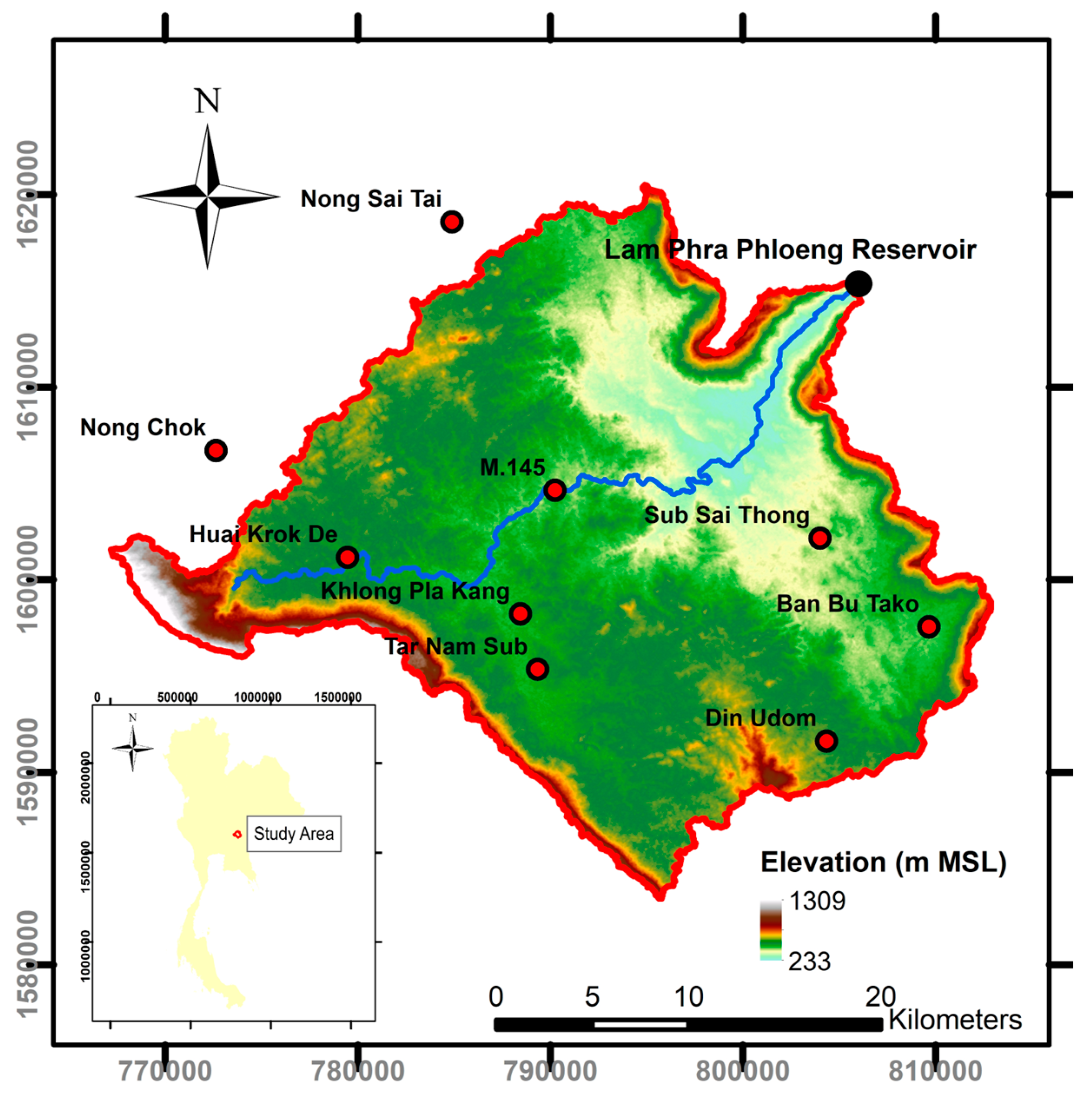
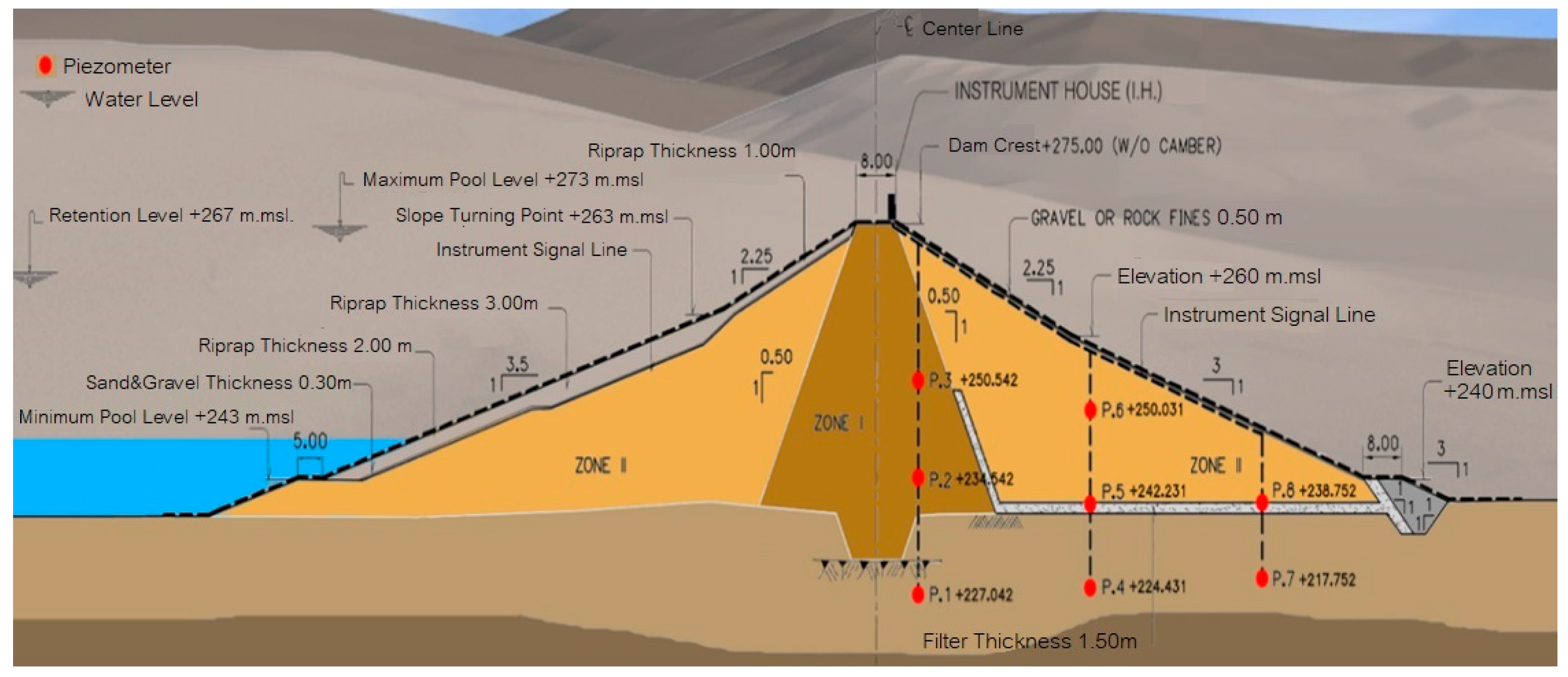
The Lam Phra Phloeng Earthfill Dam is located in Pak Thong Chai District, Nakhon Ratchasima Province, northeastern Thailand, and forms a major reservoir in the Upper Mun River Basin. The dam has a maximum height of approximately 49 m. The original full supply level of +263 m MSL was raised to +267 m MSL following structural improvement works (
Figure 1). The reservoir provides approximately 170 million m
3 of storage for irrigation, domestic water supply, and flood regulation.
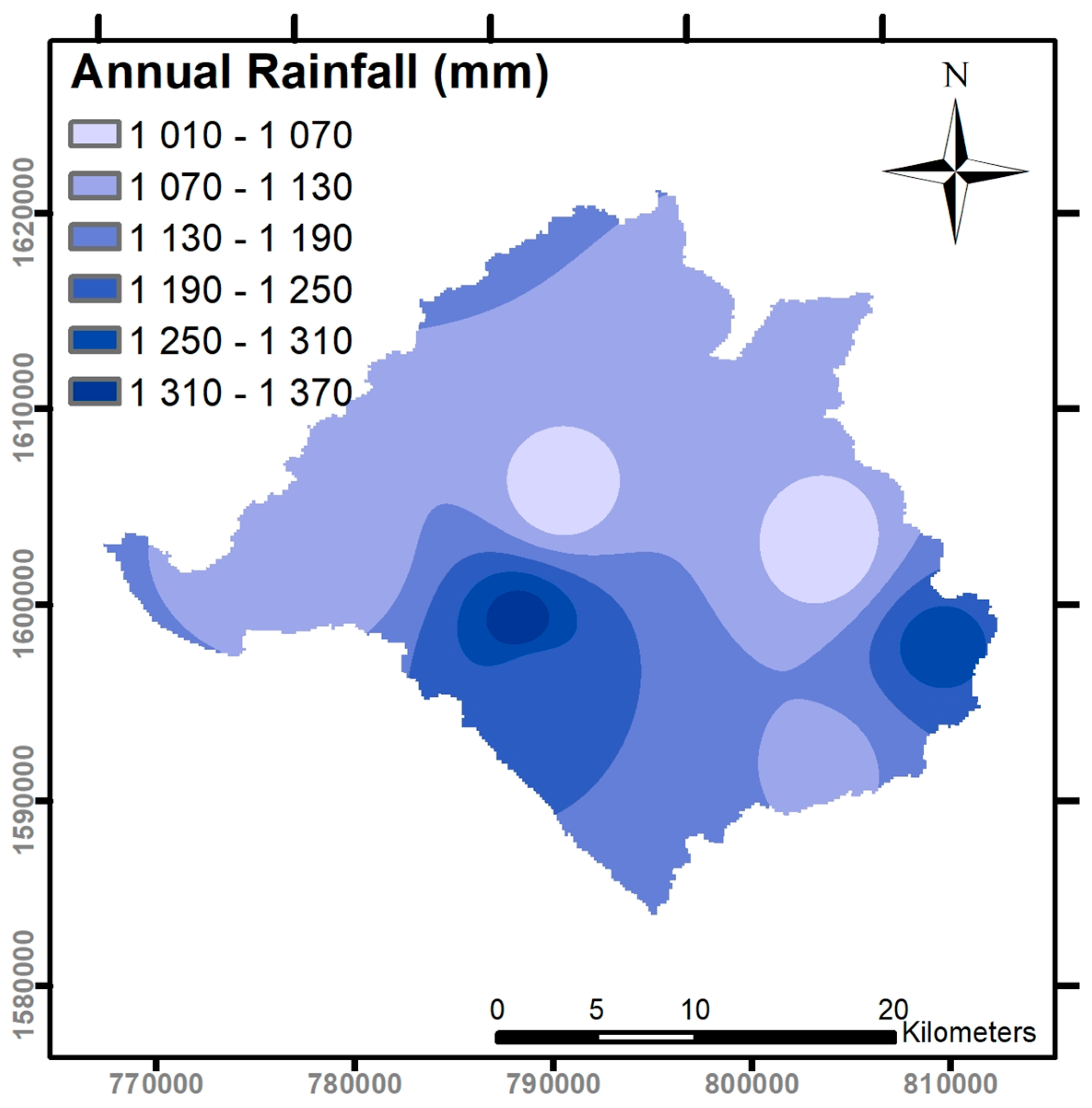
The watershed is characterized by a monsoon-driven hydrological regime, with rainfall concentrated between June and October and an average annual rainfall of approximately 1174 mm (
Figure 2). Historical hydrological records indicate several major flood events, notably in 2006, 2010, and 2013, which resulted in sustained high reservoir levels and influenced seepage behavior within the dam body and foundation [
29]. These hydrological conditions, together with structural modifications, highlight the need for updated seepage and hydraulic gradient assessment at the Lam Phra Phloeng Dam.
2.2. Flooding Record
Overtopping failure under the Probable Maximum Flood (PMF) condition is considered unlikely at the Lam Phra Phloeng Dam due to the reservoir’s flood-discharge capacity, with an estimated exceedance probability on the order of 1 × 10⁻⁵. Nevertheless, high inflow events and associated reservoir operation during extreme rainfall periods can significantly influence upstream water levels and internal hydraulic loading within the dam.
This study examines historical reservoir inflow and outflow records to characterize flood-related operational conditions relevant to seepage analysis. Particular attention is given to reservoir release strategies implemented to prevent overtopping and their hydraulic implications for downstream areas. Analysis of operational records indicates that several downstream communities have experienced flooding during major events, primarily associated with high inflow volumes combined with controlled reservoir releases.
The documented flood events summarized in
Table 1 provide context for defining realistic high-reservoir and rapid drawdown scenarios used in the numerical seepage simulations. Rather than assessing flood damage directly, these records are used to establish representative hydraulic loading conditions that influence seepage behavior, pore-water pressure development, and hydraulic gradient response within the dam body and foundation.
2.3. Instrumentation
The dam safety monitoring system includes piezometers, observation wells, settlement markers, inclinometers, and reservoir water-level sensors designed to track hydraulic and structural behavior. Instrumentation records from 2007 to 2023 were collected and screened prior to analysis. Due to equipment aging, maintenance limitations, and disturbances during dam improvement works, several piezometers exhibited abnormal behavior, including constant readings, saturated signals, or responses inconsistent with reservoir water-level fluctuations.
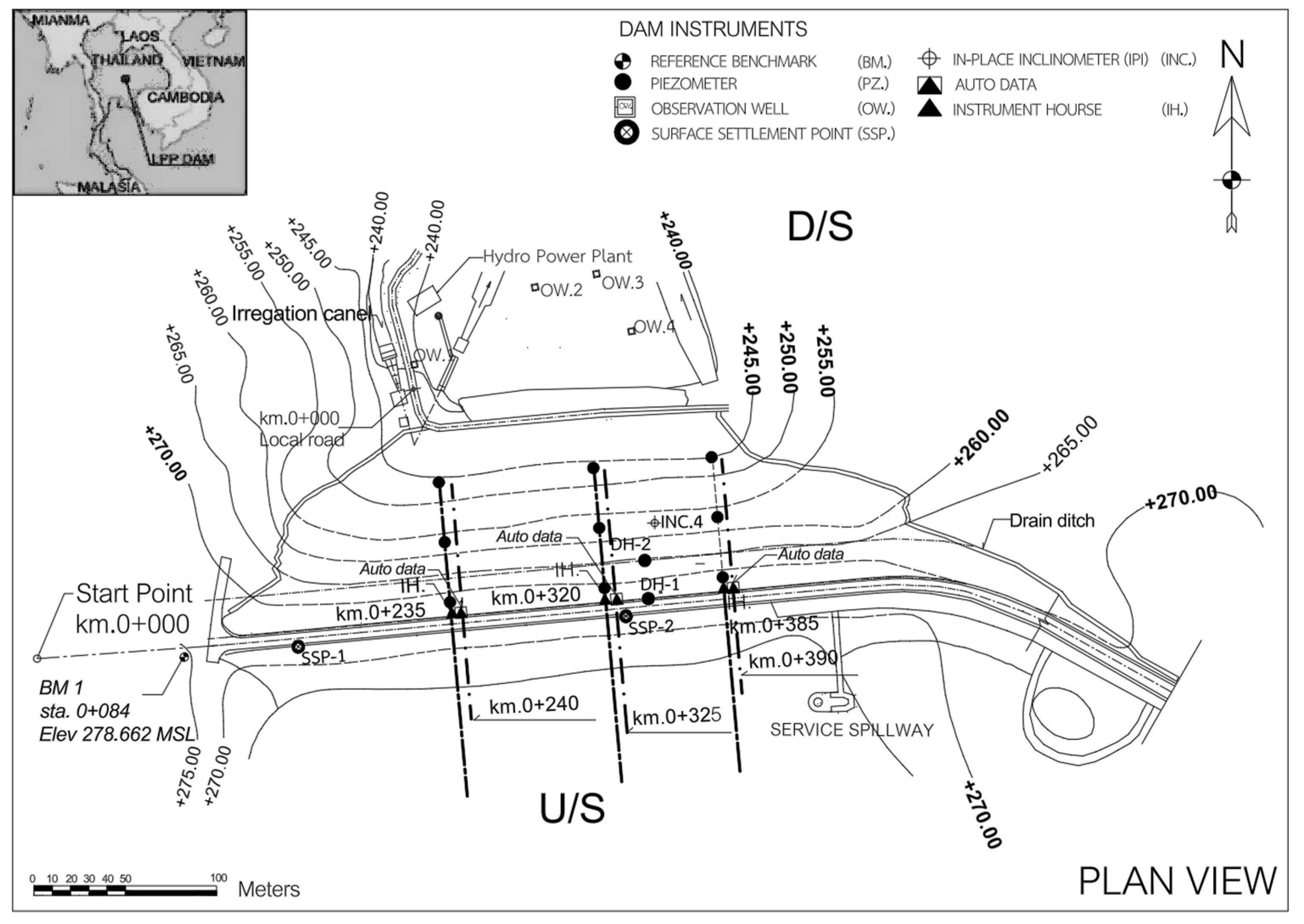
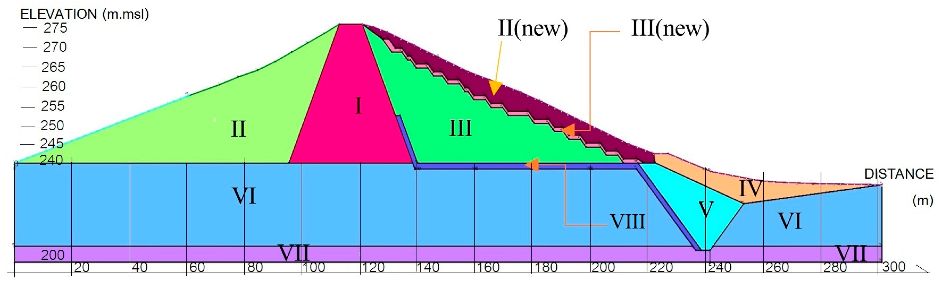
Figure 3 represents the dam geometry and internal zonation used for the numerical seepage model. The contours illustrate the ground surface and structural configuration of the dam. The elevation contours adopted in the numerical model, serving as the geometric basis for subsequent seepage simulations rather than a representation of seepage results.
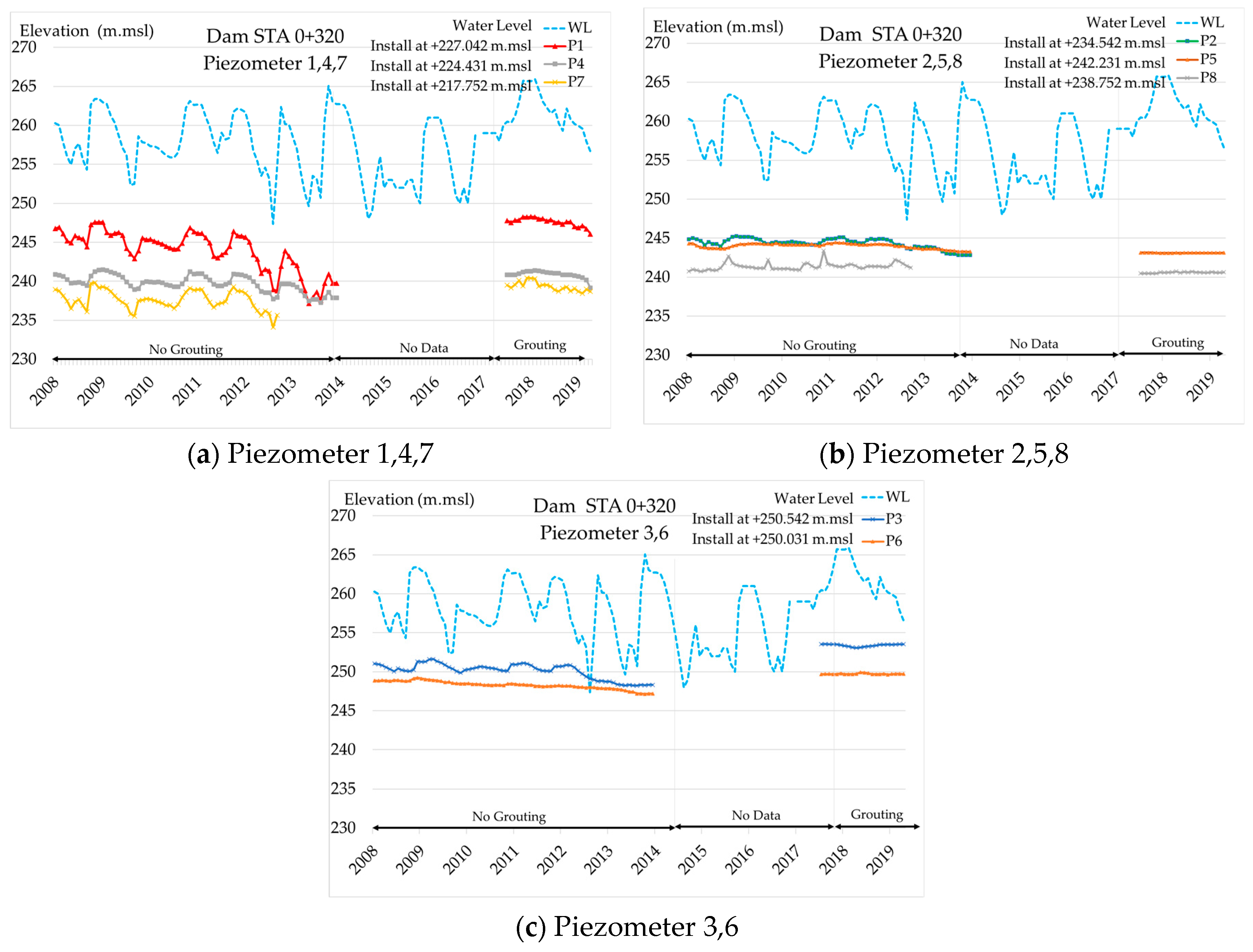
Based on these criteria, piezometers P2, P9, P10, P13, P15, P20, P23, and P24 were classified as unreliable and excluded from quantitative pore-pressure interpretation (
Figure 4). The seepage monitoring system consists primarily of standpipe piezometers with an internal diameter of approximately 50 mm, installed in boreholes with screened sections at predefined depths corresponding to target soil layers. The screened intervals are surrounded by graded filter sand and sealed with bentonite to prevent vertical leakage. Piezometric water levels were measured manually using electric water-level indicators with an accuracy of approximately ±5 mm, with measurement frequency ranging from monthly to higher-frequency observations during elevated reservoir levels [
35,
36,
37].
Valid piezometers were retained for evaluating phreatic surface trends and general seepage response. Reservoir water-level data were used as the primary reference for assessing sensor responsiveness. Piezometers installed within the low-permeability core were interpreted with caution, as delayed hydraulic response is expected during transient conditions. Under such circumstances, numerical seepage modeling provides a complementary spatial interpretation of pore-pressure distribution that cannot be obtained from sparse point measurements alone.
2.4. Hydrological Conditions
Hydrological conditions for seepage analysis were defined using long-term reservoir water-level and inflow data provided by the Royal Irrigation Department. Three representative reservoir scenarios were selected: (1) normal operating condition with water levels near +267 m MSL, (2) high reservoir condition corresponding to extreme inflow events similar to those observed in 2006, 2010, and 2013, and (3) rapid drawdown condition representing emergency reservoir operation.
The normal operating scenario reflects typical annual water-level fluctuations, whereas the high reservoir scenario represents sustained elevated water levels during major flood events (
Figure 5). The rapid drawdown scenario simulates a sudden reduction in upstream water level, which can generate adverse pore-pressure differentials within the dam body and foundation. A drawdown rate of 1.0 m/day was adopted, representing a conservative yet realistic operational rate consistent with outlet capacity and dam safety practice. These hydrological scenarios form the basis for evaluating seepage behavior and hydraulic gradient response under both steady-state and transient loading conditions.
2.5. Soil Investigation
Geotechnical information was obtained from borehole investigations and laboratory testing conducted during dam safety assessments and recent improvement works.
Table 2 presents the index properties of foundation soils obtained from boreholes DH-1 and DH-2. All samples are classified as low-plasticity clay (CL), indicating relatively uniform fine-grained foundation materials across the investigated depths. Water content ranges from 13.8% to 20.1%, liquid limit from 30.8% to 36.4%, and plasticity index from 9.2% to 14.6%, reflecting moderate plasticity and low permeability. Specific gravity (2.65–2.71) and unit weight (1.78–1.87 t/m
3) show limited variation, supporting the use of representative soil properties for seepage analysis while acknowledging inherent material variability.
Table 3 summarizes the shear strength and hydraulic conductivity parameters of foundation soils obtained from boreholes DH-1 and DH-2. The soils exhibit low to moderate cohesion (c = 15 kPa) and friction angles ranging from 15° to 16° under total stress conditions, while effective stress parameters show slightly higher resistance (c′ = 16–20 kPa, φ′ = 17–19°). Hydraulic conductivity values are on the order of 10
−7–10
−8 cm/s, confirming the low-permeability nature of the clayey foundation and supporting its role in limiting seepage under normal operating conditions.
Hydraulic conductivity values were determined from permeability tests. Representative soil strength and hydraulic parameters were assigned to engineering soil units based on laboratory results, field observations, and design documentation. Identical parameter values for samples from the same borehole reflect classification into uniform engineering units rather than depth-specific variability. To account for natural heterogeneity and uncertainty, upper and lower bounds of hydraulic conductivity were applied during sensitivity analyses.
2.6. Numerical Model (SEEP/W)
Numerical seepage analyses were performed using the SEEP/W module of the GeoStudio version 2024 software suite to simulate pore-water pressure distribution, phreatic surface position, and hydraulic gradient conditions. Representative dam cross-sections at chainages 0 + 235, 0 + 320, and 0 + 385 were selected to capture variations in dam geometry, core thickness, filter configuration, and foundation conditions. A finite element mesh with local refinement at the core–foundation interface and downstream filter zones was employed to improve numerical accuracy (
Figure 6).
Seepage flow was formulated based on Darcy’s law and the continuity equation for saturated–unsaturated flow in porous media. Under transient conditions, groundwater flow is governed by
where
is the hydraulic conductivity tensor,
is the total hydraulic head,
is the specific storage, and
is time. This formulation follows standard seepage theory and finite-element implementation commonly adopted in dam engineering practice [
8,
9,
10].
Boundary conditions were assigned by applying upstream total head levels corresponding to three hydrological scenarios: (1) normal operating reservoir level (+267 m MSL), (2) elevated flood conditions reflecting recent extreme inflow events, and (3) rapid drawdown conditions simulating emergency water release. Time-dependent upstream head reduction was applied to represent transient drawdown conditions. Downstream boundaries were assigned as seepage exit conditions. No-flow boundaries were prescribed along impermeable foundation extents and lateral model boundaries. Hydraulic conductivity anisotropy in
Table 4 was defined using vertical-to-horizontal conductivity ratios (
Kv/
Kh), with
Kh taken from
Table 3 and
Kv calculated within the SEEP/W model based on the assigned anisotropy ratios.
Although groundwater flow and soil deformation are inherently coupled through effective stress relationships, the present study adopts an uncoupled groundwater flow model. This approach is appropriate for screening-level evaluation of seepage behavior and hydraulic gradients under operational loading conditions, particularly where detailed constitutive parameters and long-term deformation data required for fully coupled analyses are unavailable. Model performance was evaluated through qualitative comparison between simulated pore-pressure trends and reliable piezometer observations, acknowledging limitations associated with incomplete instrumentation.
2.7. Hydraulic Gradient Criteria
Hydraulic gradients were evaluated using classical soil mechanics principles and the material properties of the dam and foundation soils. The critical hydraulic gradient (
icr) for the clayey foundation was estimated using the ratio of submerged unit weight to water unit weight, resulting in threshold values typically in the range of 0.9–1.0. This estimate follows the classical Terzaghi effective stress concept for upward seepage and is adopted as a conservative screening criterion for seepage-induced instability [
38,
39,
40]. Although derived for idealized homogeneous soils, this approach is widely applied in dam engineering practice and is therefore interpreted as a qualitative reference rather than an absolute failure limit.
Hydraulic gradients evaluated in this study represent local gradients obtained from SEEP/W numerical simulations. Zones where simulated gradients approached or exceeded the estimated critical value were interpreted as potentially susceptible to internal erosion or piping initiation. Hydraulic gradients within sand–gravel filter zones were additionally assessed relative to filter stability considerations to ensure acceptable seepage conditions during high reservoir levels. Gradient distributions were compared across the three reservoir scenarios, with particular attention to the deep central cross-section where elevated gradients may occur and field instrumentation is limited.
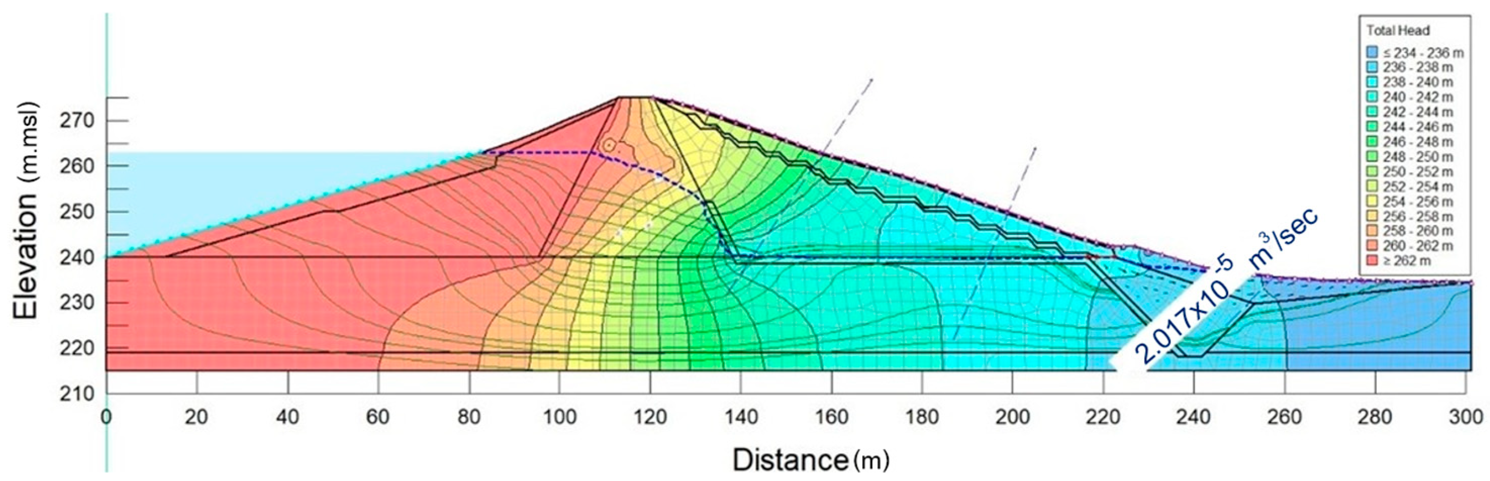
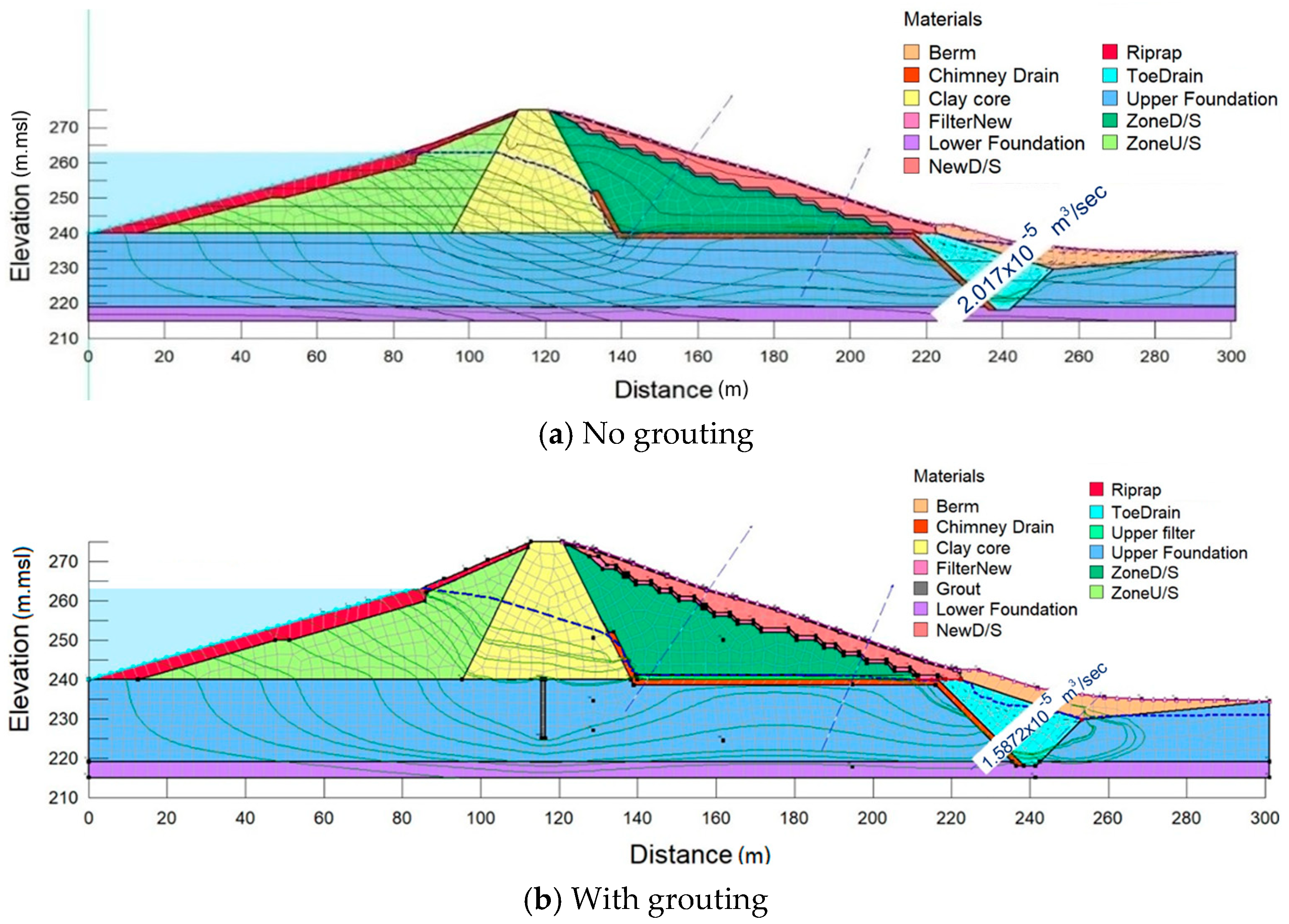
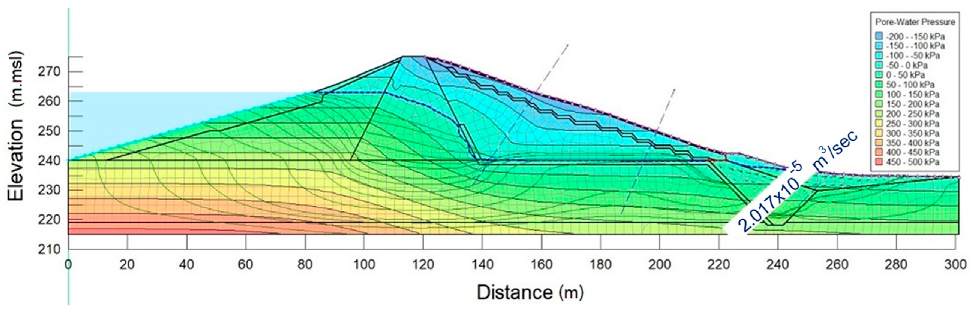
Figure 7 illustrates the simulated seepage flowlines and phreatic surface within the Lam Phra Phloeng Earthfill Dam and its foundation under the analyzed reservoir condition. Seepage follows preferential paths through the dam core and foundation and is effectively controlled by the internal drainage system. The slightly higher upstream phreatic surface observed in the grouted foundation scenario results from hydraulic head redistribution due to reduced permeability, not from increased seepage discharge. Foundation grouting may locally increase upstream pore-water pressure by restricting preferential vertical seepage paths, leading to a redistribution of hydraulic head and a higher upstream phreatic surface without necessarily increasing seepage discharge. In such conditions, phreatic surface elevation alone is not a sufficient indicator of seepage-related risk. Consequently, dam safety in this study is evaluated primarily based on hydraulic gradient magnitude and internal erosion susceptibility, which more directly govern piping initiation and progressive erosion, particularly near interfaces between treated and untreated foundation zones.
2.8. Model Calibration and Validation
Model calibration (
Table 5) and validation (
Table 6) were based on consistency between simulated pore-water pressure distributions and available reliable piezometer data. Due to malfunction or non-responsiveness of several instruments, particularly in the middle and deep zones of the dam, full spatial calibration of the numerical model was not possible. However, agreement between simulated phreatic levels and responsive piezometers in upstream, downstream, and shallow foundation zones supports the reliability of the modeled seepage patterns.
Sensitivity analyses were conducted by varying hydraulic conductivity within ranges obtained from laboratory testing and literature-based uncertainty. These analyses were used to evaluate the robustness of simulated seepage behavior and to identify zones with relatively elevated seepage risk, particularly where field data coverage is limited. In such areas, numerical results are interpreted conservatively and used to assess relative hydraulic behavior and gradient distribution, rather than exact pore-pressure values.
Due to malfunction or non-responsiveness of several piezometers, particularly in the middle and deep zones of the dam, full spatial validation of the numerical seepage model was not possible. Model calibration was therefore performed using reliable piezometer and observation-well data from upstream, downstream, and shallow foundation zones. For poorly instrumented zones, numerical results are interpreted conservatively and used to identify relative seepage risk rather than exact hydraulic conditions.
2.9. Failure Mode Consideration
The assessment of potential failure modes was based on observed field conditions, available instrumentation data, soil properties, and numerical seepage results. The analysis focuses on seepage-related failure mechanisms, which are among the most critical threats to the safety of aging earthfill dams. The primary mechanisms considered include internal erosion and piping at the core–foundation interface, progressive internal erosion beneath downstream filter zones, excessive uplift pressure within the downstream shell, and seepage-induced instability associated with elevated hydraulic gradients.
Rapid drawdown was identified as a critical operational scenario because it can generate steep pore-pressure gradients that dissipate slowly in low-permeability core and foundation materials. Such conditions may reduce the factor of safety against downstream slope instability and increase susceptibility to localized internal erosion. In this study, rapid drawdown was simulated using a reservoir water-level reduction rate of 1.0 m/day, representing a conservative yet realistic operational rate commonly adopted in dam safety assessments and emergency reservoir operations.
Historical hydrological loading and incomplete instrumentation coverage introduce uncertainty in identifying exact seepage pathways and pore-pressure magnitudes. Consequently, failure mode evaluation is interpreted conservatively and emphasizes relative seepage behavior and gradient distribution, rather than absolute failure prediction. The combined assessment of seepage patterns, hydraulic gradients, and soil characteristics provides a practical basis for identifying zones requiring enhanced monitoring, maintenance, or mitigation measures.
This study focuses on seepage-related failure modes associated with earthfill dams, with particular emphasis on internal erosion mechanisms. The failure modes considered include the initiation of piping at the core–foundation interface, progressive internal erosion beneath downstream filter zones, and localized seepage-induced instability resulting from elevated hydraulic gradients. Other potential failure mechanisms, such as slope instability, overtopping, seismic-induced deformation, and structural failure of appurtenant works, are not addressed in this study, as they require different analytical approaches and are beyond the scope of the present seepage-focused investigation.
3. Results
The integrated evaluation of field instrumentation data, numerical seepage simulations, and hydraulic gradient analysis provides insight into the current seepage behavior of the Lam Phra Phloeng Earthfill Dam under varying reservoir conditions. Although several piezometers exhibited malfunctioning or inconsistent responses, the remaining reliable sensors, together with calibrated SEEP/W simulations, allow qualitative interpretation of phreatic surface movement, seepage pathways, and spatial variation in hydraulic gradients. The results identify zones exhibiting stable seepage performance as well as areas where elevated hydraulic loading or limited monitoring coverage may increase vulnerability, particularly during high reservoir levels and rapid drawdown conditions.
3.1. Piezometer Performance
Analysis of long-term piezometer records revealed considerable variability in sensor performance. Several piezometers (P2, P9, P10, P13, P15, P20, P23, and P24) exhibited abnormal behavior, including constant readings, delayed or reversed hydraulic responses, and abrupt changes unrelated to reservoir fluctuations. These anomalies are attributed to aging equipment, clogging, sedimentation, or disturbance during dam improvement works, rendering these instruments unsuitable for quantitative interpretation. In contrast, the remaining functional piezometers demonstrated consistent hydraulic responses to reservoir level variations, with pore-water pressures increasing during high reservoir stages and gradually dissipating during drawdown (
Figure 8). These sensors provide reliable indicators of phreatic surface trends and were used to support qualitative validation of numerical seepage results. Nevertheless, the loss of data coverage in deeper and central zones limits direct verification of subsurface conditions, highlighting the need for enhanced monitoring redundancy.
3.2. Seepage Distribution
Numerical seepage simulations indicate that under normal operating conditions, seepage remains well controlled (
Figure 9). The phreatic surface is confined within the impervious core and transitions smoothly into the downstream drainage system, with seepage discharge at the toe remaining within acceptable limits. Flow vectors under steady-state conditions show predominantly downward and horizontal seepage through the core, consistent with expected behavior of clay-core earthfill dams.
Under elevated reservoir levels, the phreatic surface rises and pore-water pressures increase, particularly within the mid-depth of the core and along the core–foundation interface. Despite this increase, seepage remains effectively intercepted by the downstream filter and drainage system, suggesting that the dam’s internal drainage continues to function as intended. However, increased hydraulic loading under high reservoir conditions, combined with limited piezometer coverage in deeper zones, underscores the importance of continued monitoring and conservative interpretation.
3.3. Hydraulic Gradient Analysis
Hydraulic gradients were evaluated at critical seepage locations identified from numerical simulations, rather than as full two-dimensional contour maps, to focus on zones governing seepage-induced instability. Key locations include the core–foundation interface and downstream transition zones.
Under normal reservoir conditions, computed hydraulic gradients remain below the estimated critical range (approximately 0.9–1.0) for clayey foundation soils. These values indicate stable seepage conditions when interpreted in a qualitative, screening-level context. Because internal erosion is a progressive and soil-dependent process, proximity to the critical gradient is interpreted as an indicator of relative sensitivity rather than imminent failure.
Under high reservoir scenarios, hydraulic gradients increase noticeably at the core–foundation contact and beneath downstream filter zones, with the most pronounced response observed at chainage 0 + 320. Although gradients do not exceed the estimated critical threshold, their approach toward this range suggests increased vulnerability under additional loading or undetected changes in material properties. Sensitivity analyses further show that gradient magnitudes are strongly influenced by assumed hydraulic conductivity, reinforcing the need for improved instrumentation to reduce uncertainty and enhance confidence in future seepage assessments.
4. Discussion
4.1. Implications for Dam Safety Management
The seepage behavior and hydraulic gradient results obtained in this study provide important insights for dam safety management of the Lam Phra Phloeng Earthfill Dam within a risk-informed evaluation framework. Rather than serving as deterministic predictions of failure, the results support qualitative decision-making under uncertainty, which is particularly relevant for aging dams with incomplete or partially unreliable instrumentation. By integrating field monitoring performance, numerical seepage simulations, and hydraulic gradient evaluation, potential seepage-related failure mechanisms were assessed following the principles of Potential Failure Modes Analysis (PFMA).
Among the seepage-related mechanisms considered, internal erosion initiated by elevated hydraulic gradients at the core–foundation interface and beneath downstream transition zones represents the most credible risk. Under normal reservoir operation, simulated hydraulic gradients remain well below the estimated critical gradient for the clayey foundation (icr ≈ 0.9–1.0), indicating a low likelihood of seepage-induced instability. However, under high-reservoir and rapid drawdown scenarios, localized gradients in the central dam section (chainage 0 + 320) increase to approximately 70–85% of the critical threshold, particularly in deeper zones with limited instrumentation coverage. Although these values do not exceed critical limits, their proximity indicates a reduced safety margin under adverse hydraulic loading.
Key influencing factors such as soil strength, hydraulic conductivity anisotropy, and foundation grouting were represented through material zoning and parameter selection based on available investigations. However, systematic sensitivity analysis of these parameters was not undertaken, and the results should therefore be interpreted as representative of current conditions rather than exhaustive parametric evaluations. Accordingly, this study does not provide formal safety factors or limit-state verification but instead offers a screening-level assessment to identify zones and mechanisms warranting closer attention.
Rapid drawdown was identified as the most critical operational condition, as delayed pore-pressure dissipation within low-permeability materials produces transient hydraulic gradients that may promote progressive internal erosion. Instrumentation reliability strongly influences safety confidence; malfunctioning piezometers in deep and central zones create monitoring blind spots that limit direct verification of seepage conditions. Consequently, hydraulic gradient distributions derived from calibrated numerical models provide a valuable complementary tool for ranking seepage-related risks when monitoring data are incomplete. Overall, the results emphasize the importance of conservative operational controls and targeted monitoring enhancements to support long-term dam safety management [
41].
4.2. Hydrological Context and Reservoir Operation Implications
The seepage behavior and hydraulic gradient response of the Lam Phra Phloeng Earthfill Dam are strongly governed by watershed-scale hydrological processes and reservoir operation strategies, which together determine upstream hydraulic loading and subsurface flow conditions within the dam body and foundation. Analysis of long-term rainfall, inflow, and reservoir water-level records indicates that the elevated reservoir levels adopted in the numerical simulations correspond to extreme hydrological conditions associated with high-return-period rainfall events. In particular, the simulated high-reservoir scenario is representative of inflow magnitudes comparable to approximately 20–50 year events, consistent with historical flood episodes recorded in 2006, 2010, and 2013.
Numerical seepage simulations demonstrate that increases in reservoir level from normal operation to high-water conditions result in a systematic rise in pore-water pressures within the upstream shell, the low-permeability core, and along the core–foundation interface. This response is spatially non-uniform, with the most pronounced changes occurring at the central dam section (chainage 0 + 320), where dam geometry and foundation depth concentrate hydraulic loading. At this location, simulated hydraulic gradients increase by approximately 30–40% relative to normal operating conditions. These results indicate that seepage behavior at the Lam Phra Phloeng Dam is highly sensitive not only to peak reservoir level but also to the duration of elevated storage, highlighting the direct coupling between reservoir operation and internal hydraulic conditions.
Sustained high reservoir levels increase total hydraulic head acting on the dam and foundation, leading to elevated pore-water pressures and steeper hydraulic gradients in critical zones. Although the internal drainage system remains effective under the analyzed conditions, prolonged periods of high water level reduce the available hydraulic safety margin by maintaining elevated gradients near erosion-prone interfaces. These findings emphasize that operational decisions related to flood storage and water supply directly influence seepage-related risk, particularly in aging dams where material properties and drainage performance may have evolved over time.
Reservoir drawdown strategy is identified as a key operational control on transient seepage response. While controlled releases are essential for flood mitigation and reservoir safety, rapid drawdown generates unfavorable hydraulic conditions within the embankment. The rapid drawdown scenario analyzed in this study produces steep pore-pressure differentials between the upstream and downstream zones, which persist due to delayed dissipation in the low-permeability core and foundation soils. As a result, transient hydraulic gradients temporarily increase and approach conservative critical thresholds, particularly at the core–foundation interface and beneath downstream transition zones. Although the present analysis focuses on transient seepage behavior and does not explicitly incorporate coupled stress–strain or deformation processes, such conditions are widely recognized as contributing to progressive internal erosion and reduced stability margins in earthfill dams.
Projected increases in rainfall intensity and hydrological variability associated with climate change are expected to further challenge reservoir operation and dam safety management in the region. Regional climate assessments for northeastern Thailand indicate a tendency toward more intense monsoon rainfall and an increased frequency of extreme inflow events. These trends may lead to more frequent high-reservoir conditions and greater reliance on rapid drawdown operations, thereby increasing cumulative seepage-related stresses on aging embankment dams. Although quantitative climate projections were beyond the scope of this study, the results underscore the importance of considering future hydrological variability in seepage assessments and operational planning.
Overall, the findings demonstrate the need to integrate seepage response indicators—particularly hydraulic gradient evolution—into adaptive reservoir operation frameworks. Incorporating hydraulic gradient thresholds alongside conventional water-level criteria would enable dam operators to anticipate adverse subsurface hydraulic responses during extreme hydrological events and to balance flood control, water supply reliability, and internal dam safety more effectively. This integrated approach is especially important for aging dams with incomplete instrumentation, where numerical seepage modeling and hydraulic gradient analysis provide essential support for risk-informed operational decision-making.
4.3. Hydraulic Gradient, Internal Erosion, and Progressive Seepage Risk
Hydraulic gradient analysis provides a practical and mechanism-oriented framework for evaluating seepage-induced internal erosion in earthfill dams, particularly under conditions of limited or partially degraded monitoring systems. In this study, local hydraulic gradients were evaluated as relative indicators of seepage vulnerability rather than absolute failure criteria, consistent with the screening-level objective of the analysis.
The critical hydraulic gradient (icr) adopted in this study refers explicitly to local critical conditions, evaluated at specific locations where seepage forces concentrate, such as the core–foundation interface and downstream transition zones. For the clayey foundation materials, icr was estimated using classical effective stress concepts following the Terzaghi formulation for upward seepage, yielding values of approximately 0.9–1.0. This approach was intentionally selected as a conservative first-order reference, recognizing that it does not explicitly account for soil fabric, plasticity, anisotropy, or progressive erosion mechanisms. As emphasized in the revised manuscript, the estimated icr is applied solely as a qualitative benchmark to support relative risk comparison under different hydraulic scenarios, rather than as a definitive failure threshold.
Numerical seepage simulations indicate that maximum local hydraulic gradients consistently develop beneath the downstream transition zone and along the core–foundation contact at the central dam section (chainage 0 + 320). Under normal reservoir operating conditions, computed gradients remain below approximately 50% of the estimated local critical gradient, suggesting a low likelihood of erosion initiation. In contrast, under high-reservoir and rapid drawdown scenarios (drawdown rate of 1.0 m/day), local gradients increase to approximately 70–85% of icr. Although these values do not exceed the critical threshold, the reduced safety margin highlights the sensitivity of seepage behavior to extreme hydraulic loading conditions.
Sensitivity analyses further demonstrate that modest increases in hydraulic conductivity—within the range of measured variability and representative parameter uncertainty—can result in noticeable increases in local hydraulic gradients. This finding underscores the importance of epistemic uncertainty in seepage risk assessment, particularly for aging dams where material properties and instrumentation performance may have degraded over time. In zones lacking reliable piezometric data, the numerical results are therefore interpreted conservatively and used to identify potentially vulnerable areas rather than to predict exact pore-pressure magnitudes.
The present analysis employs uncoupled seepage modeling, which captures transient hydraulic responses associated with reservoir level fluctuations but does not explicitly represent coupled stress–strain effects. As noted by previous studies, rapid reservoir level changes may induce additional pore-pressure responses in low-permeability and relatively compressible core materials due to mechanical loading effects that cannot be simulated using seepage-only models. Consequently, the computed pore-pressure and hydraulic gradient distributions are interpreted as indicative of hydraulic trends and spatial patterns rather than instantaneous in situ conditions. This limitation has been explicitly acknowledged to ensure consistency between model assumptions and result interpretation.
Filter and transition zone performance plays a critical role in mitigating seepage-induced erosion. The computed hydraulic gradients within sand–gravel filter zones remain within ranges generally considered acceptable based on classical filter design principles. While this suggests adequate retention capacity under the analyzed scenarios, filter performance is inherently dependent on gradation compatibility, construction quality, and long-term material degradation. Therefore, continued inspection and monitoring remain essential, particularly under elevated hydraulic loading conditions.
Internal erosion in earthfill dams should be regarded as a progressive and cumulative process, rather than a binary failure state. Repeated exposure to elevated hydraulic gradients—especially during high-reservoir and rapid drawdown conditions—may promote gradual particle detachment and the development of preferential seepage pathways over long time scales, even when critical thresholds are not exceeded. The absence of immediate piping or abnormal seepage discharge does not preclude the potential for long-term degradation, particularly in zones with sparse or unreliable instrumentation [
42,
43].
Overall, the results demonstrate that maximum local hydraulic gradient evaluation provides a more sensitive and diagnostic indicator of seepage-related vulnerability than phreatic surface position alone. By explicitly accounting for data limitations, modeling assumptions, and parameter uncertainty, this study advances a practical and transferable framework for seepage risk screening and dam safety decision support in aging earthfill dams operating under realistic hydraulic and monitoring constraints.
5. Limitations, Future Research Perspectives, and Recommendations
Despite providing valuable insight into seepage behavior and hydraulic gradient distribution at the Lam Phra Phloeng Earthfill Dam, this study has several limitations that should be acknowledged. First, the analysis is based on deterministic seepage modeling using representative soil parameters derived from available field and laboratory data. Spatial variability of material properties, uncertainty in hydraulic conductivity, and permeability anisotropy were simplified, which may affect localized seepage responses under extreme hydraulic loading.
Second, numerical model calibration is constrained by limited instrumentation reliability. Several piezometers in the central and deep foundation zones were excluded due to abnormal or non-responsive readings, reducing validation coverage in hydraulically critical areas. Although cross-checks using multiple datasets were performed, residual epistemic uncertainty remains.
Third, internal erosion risk was evaluated using classical critical hydraulic gradient concepts as a conservative, screening-level indicator. This approach does not explicitly capture soil microstructural effects, progressive erosion mechanisms, or time-dependent degradation of erosion resistance. In addition, coupled hydro-mechanical processes—such as stress-induced pore-pressure response during rapid drawdown—were not explicitly modeled.
Future research should incorporate coupled seepage–stress–strain analyses to better represent transient pore-pressure behavior and deformation under rapid drawdown and extreme reservoir conditions. The application of probabilistic and reliability-based approaches would further improve quantification of seepage-related uncertainty. Enhanced field investigations, including upgraded sensor networks such as vibrating-wire piezometers or distributed fiber-optic sensing, would substantially strengthen long-term monitoring and model validation.
From a practical perspective, this study recommends increasing instrumentation redundancy in deep foundation zones, refining operational rules to limit rapid drawdown rates, and incorporating hydraulic gradient thresholds into routine dam safety evaluation frameworks. These measures would improve early-warning capability and support risk-informed management of aging earthfill dams under increasing hydrological variability.
6. Conclusions
This study presents an integrated seepage assessment of the Lam Phra Phloeng Earthfill Dam by combining long-term piezometric observations with deterministic numerical seepage modeling. By systematically screening instrumentation records from 2007 to 2023 and incorporating updated geotechnical parameters into SEEP/W simulations, the research provides a realistic representation of seepage behavior under operationally relevant reservoir conditions. The approach explicitly addresses data limitations commonly encountered in aging dams, where incomplete or malfunctioning instrumentation constrains direct interpretation of subsurface hydraulic conditions.
The results confirm that under normal reservoir operation, seepage within the dam body and foundation remains well controlled by the internal drainage system, with hydraulic gradients substantially below conservative critical thresholds for the clayey foundation materials. These findings indicate an adequate hydraulic safety margin under routine conditions. However, elevated reservoir levels and rapid drawdown scenarios produce pronounced increases in pore-water pressure and localized hydraulic gradients, particularly at the core–foundation interface in the central dam section. Although calculated gradients did not exceed estimated critical values, their proximity to threshold conditions indicates a reduction in the safety margin under unfavorable hydraulic loading.
A key contribution of this study is the demonstration that maximum local hydraulic gradients provide a more sensitive and operationally relevant indicator of seepage-related risk than phreatic surface position alone. While phreatic line elevation reflects overall seepage geometry, hydraulic gradients directly govern internal erosion initiation and progressive piping potential. This distinction is especially important in data-limited settings, where reliance on phreatic surface interpretation alone may obscure localized zones of elevated seepage force.
Rapid drawdown was identified as the most critical operational condition from a seepage risk perspective. Transient pore-pressure differentials generated during drawdown persist within low-permeability core and foundation materials, creating unfavorable hydraulic gradients even in the absence of visible seepage anomalies. Although no immediate failure mechanisms were identified, repeated exposure to such conditions may promote cumulative internal erosion over long time scales, particularly in zones with limited monitoring coverage.
The study also highlights the central role of instrumentation reliability in dam safety confidence. Malfunctioning piezometers significantly reduce the ability to validate numerical predictions and detect abnormal hydraulic behavior in real time. By integrating available field data with conservative numerical modeling, this research demonstrates a practical framework for risk-informed seepage assessment, where numerical results are interpreted as relative indicators of vulnerability rather than deterministic predictions.
Overall, this work advances a pragmatic and transferable methodology for seepage evaluation in aging earthfill dams by explicitly accounting for operational scenarios, hydraulic gradient-based indicators, and epistemic uncertainty arising from incomplete monitoring. The findings support the use of hydraulic gradient thresholds as part of adaptive dam safety management, linking reservoir operation, monitoring strategies, and seepage risk under increasing hydrological variability.
Author Contributions
P.T. provided conceptualization, ideas, and suggestions, model construction, original draft preparation and edited the manuscript. U.S. (Uma Seeboonruang) provided writing—review and editing and funding acquisition. U.S. (Uba Sirikaew) provided field investigation, established the model, writing, review and editing the manuscript. W.H. provide writing and editing the manuscript. All authors have read and agreed to the published version of the manuscript.
Funding
The research on impact of climate change on flood hazard of Lam Phra Phloeng Watershed based on global (CMIP6) climate models and satellite-based observations by King Mongkut’s Institute of Technology Ladkrabang, School of Engineering, Department of Civil Engineering has received funding support from the National Science, Research and Innovation Fund or “NSRF” Grant No. RE-KRIS/FF69/46. Special thanks to the School of Engineering, King Mongkut’s Institute of Technology Ladkrabang Grant No.2565-02-01-083 for sponsorship.
Data Availability Statement
The original contributions presented in this study are included in the article. Further inquiries can be directed at the corresponding authors.
Acknowledgments
Sincere appreciation is extended to the Thai Land Development Department, the Thai Royal Irrigation Department for data and information. During the preparation of this manuscript, the authors used ChatGPT-4 for the purposes of language polishing, grammar checking, and improvement of language‘s clarity and readability. The authors have reviewed and edited the AI-assisted output and take full responsibility for the content of this publication.
Conflicts of Interest
The authors declare no conflicts of interest.
References
- Adamo, N.; Al-Ansari, N.; Sissakian, V.; Laue, J.; Knutsson, S. Dam Safety Problems Related to Seepage. J. Earth Sci. Geotech. Eng. 2020, 10, 191–239. [Google Scholar]
- Omofunmi, O.; Kolo, J.; Oladipo, A.; Diabana, P.; Ojo, A. A Review on Effects and Control of Seepage through Earth-Fill Dam. Curr. J. Appl. Sci. Technol. 2017, 22, 1–11. [Google Scholar] [CrossRef] [Scilit]
- Liu, Z.; Chen, Q.; Li, X.; Chen, C.; Zhou, C.; Wang, C. A Review of the Research on the Failure Potential of Landslide Dams Caused by Overtopping and Seepage. Nat. Hazards 2022, 116, 1513–1538. [Google Scholar] [CrossRef] [Scilit]
- Talukdar, P.; Dey, A. Hydraulic Failures of Earthen Dams and Embankments. Innov. Infrastruct. Solut. 2019, 4, 42. [Google Scholar] [CrossRef] [Scilit]
- Liu, G.; Zhou, Z.; Zhang, J.; Jiang, G.; Mi, W. Seepage and Stability Analysis of Earth Dams’ Downstream Slopes, Considering Hysteresis in Soil–Water Characteristic Curves under Reservoir Water Level Fluctuations. Water 2024, 16, 1811. [Google Scholar] [CrossRef] [Scilit]
- Aniskin, N.; Stupivtsev, A.; Sergeev, S.; Bokov, I. The Drawdown of a Reservoir: Its Effect on Seepage Conditions and Stability of Earth Dams. Water 2024, 16, 2660. [Google Scholar] [CrossRef] [Scilit]
- Zheng, X.; Yan, B.; Wang, W.; Du, K.; Fang, Y. Seepage–Deformation Coupling Analysis of a Core Wall Rockfill Dam Subject to Rapid Fluctuations in the Reservoir Water Level. Water 2024, 16, 1621. [Google Scholar] [CrossRef] [Scilit]
- Bear, J. Hydraulics of Groundwater; McGraw-Hill: New York, NY, USA, 1979; p. 299. [Google Scholar]
- Bear, J.; Verruijt, A. Modeling Groundwater Flow and Pollution; D.Reidel Publishing Company: Dordrecht, The Netherlands, 1992; 414p. [Google Scholar]
- Říha, J. Groundwater Flow Problems and Their Modelling. In Assessment and Protection of Water Resources in the Czech Republic; Zelenakova, M., Fialová, J., Negm, A.M., Eds.; Springer International Publishing: Cham, Germany, 2020; pp. 175–199. [Google Scholar]
- Zhao, J.; Xu, Y.; Zhu, W.; Liu, M.; Zhao, J. Real-Time Early Safety Warning for Personnel Intrusion Behavior on Construction Sites Using a CNN Model. Buildings 2023, 13, 2206. [Google Scholar] [CrossRef] [Scilit]
- Khalil, M.A.; Barrick, D.; Joeckel, R.M. Characterization of Seepage in an Earthfill Dam by the Integration of Geophysical Surveys and Geotechnical Data. J. Appl. Geophys. 2024, 220, 105273. [Google Scholar] [CrossRef] [Scilit]
- Torabi Haghighi, A.; Tuomela, A.; Hekmatzadeh, A.A. Assessing the Efficiency of Seepage Control Measures in Earthfill Dams. Geotech. Geol. Eng. 2020, 38, 5667–5680. [Google Scholar] [CrossRef] [Scilit]
- Kayode, O.T.; Odukoya, A.M.; Adagunodo, T.A.; Adeniji, A.A. Monitoring of Seepages around Dams Using Geophysical Methods: A Brief Review. IOP Conf. Ser. Earth Environ. Sci. 2018, 173, 012026. [Google Scholar] [CrossRef] [Scilit]
- Cheng, X.; Li, Q.; Zhou, Z.; Luo, Z.; Liu, M.; Liu, L. Research on a Seepage Monitoring Model of a High Core Rockfill Dam Based on Machine Learning. Sensors 2018, 18, 2749. [Google Scholar] [CrossRef] [Scilit]
- Asmaranto, R.; Sisinggih, D.; Rastanto, R.N. Fluctuation Effect of Reservoir Water Level on the Seepage of Earth-Fill Dam. Int. J. Recent Technol. Eng. 2021, 9, 11–19. [Google Scholar] [CrossRef] [Scilit]
- Wang, Y.; Li, J.; Wu, Z.; Chen, J.; Yin, C.; Bian, K. Dynamic Risk Evaluation and Early Warning of Crest Cracking for High Earth-Rockfill Dams through Bayesian Parameter Updating. Appl. Sci. 2020, 10, 7627. [Google Scholar] [CrossRef] [Scilit]
- Bashar, N.A.M.; Zainol, M.R.R.M.A.; Aziz, M.S.A.; Mazlan, A.Z.A.; Zawawi, M.H.; Manan, T.S.A. Comprehensive Review on Sustainable Dam Infrastructure: Issues and Challenges, Factors Causing Dam Failure and Future Direction in a Globally Changing Climate. Pertanika J. Sci. Technol. 2025, 33, 1387–1412. [Google Scholar] [CrossRef] [Scilit]
- Adamo, N.; Al-Ansari, N.; Hussain Ali, S.; Laue, J.; Knutsson, S. Dams Safety: Review of Satellite Remote Sensing Applications to Dams and Reservoirs. J. Earth Sci. Geotech. Eng. 2020, 11, 347–438. [Google Scholar] [CrossRef] [Scilit] [PubMed]
- Thothong, W.; Huon, S.; Janeau, J.L.; Boonsaner, A.; de Rouw, A.; Planchon, O.; Bardoux, G.; Parkpian, P. Impact of Land Use Change and Rainfall on Sediment and Carbon Accumulation in a Water Reservoir of North Thailand. Agric. Ecosyst. Environ. 2011, 140, 521–533. [Google Scholar] [CrossRef] [Scilit]
- Promping, T.; Tingsanchali, T. Effects of Climate Change and Land-Use Change on Future Inflow to a Reservoir: A Case Study of Sirikit Dam, Upper Nan River Basin, Thailand. GMSARN Int. J. 2022, 16, 366–376. [Google Scholar]
- Kosa, P.; Sukwimolseree, T. Simulation of Flood Protection Using Hec Ras Modeling: A Case Study of the Lam Phra Phloeng River Basin. J. Appl. Res. Sci. Technol. 2024, 23, 254752. [Google Scholar] [CrossRef] [Scilit]
- Kongkhiaw, P.; Yossapol, C.; Tantemsapya, N. Quantification Prediction Soil Losses in Nakhon Ratchasima, Thailand. Naresuan Univ. J. Sci. Technol. 2021, 3, 78–95. [Google Scholar]
- Baird, I.G.; Manorom, K.; Phenow, A.; Gaja-Svasti, S. Opening the Gates of the Pak Mun Dam: Fish Migrations, Domestic Water Supply, Irrigation Projects and Politics. Water Altern. 2020, 13, 141–159. [Google Scholar]
- Prabnakorn, S.; Ruangpan, L.; Tangdamrongsub, N.; Suryadi, F.X.; de Fraiture, C. Improving Flood and Drought Management in Agricultural River Basins: An Application to the Mun River Basin in Thailand. Water Policy 2021, 23, 1153–1169. [Google Scholar] [CrossRef] [Scilit]
- Mostafa, M.M.; Zhenzhong, S. Effect of Zones’ Dimensions and Geometry on Seepage through Zoned Earth Dams. J. Eng. Appl. Sci. 2023, 70, 46. [Google Scholar] [CrossRef] [Scilit]
- Hadi, A.J.; Mohammed, T.A.; Tayebian, A. A Study on Seepage Data Utilized in the Safety Assessment of Haditha Dam: A Simulation by SEEP/W Model. Environ. Heal. Eng. Manag. 2024, 11, 285–292. [Google Scholar] [CrossRef] [Scilit]
- Aghamijidi, R.; Vakili, A. Analysis of Seepage through an Earth Dam Using the Energy Equation and Comparison with the Seep/W Numerical Model (A Case Study of Maroon Reservoir Dam). J. Build. Inf. Model. 2025, 1, 51–67. [Google Scholar] [CrossRef]
- Polpanich, O.; Nongpho, K.; Boonwan, K.; Chandraphabha, C.; Hakari, M.; Samarakoon, L. Integration of RS/GIS for Estimation of Soil Erosion in Lam Phra Phloeng Reservior, Nakhon Ratchasima Province, Thailand. In Proceedings of the 31st Asian Association on Remote Sensing 2010, Hanoi, Vietnam, 1–5 November 2010; pp. 768–773. Available online: https://www.proceedings.com/content/010/010941webtoc.pdf (accessed on 20 November 2020).
- Geotech and Engineering Service Company Limited. Report on Installation, Monitoring, and Data Recording of Dam Behavior Instrumentation: Lam Phra Phloeng Project, Nakhon Ratchasima Province; Geotech and Engineering Service Company Limited: Pathum Thani, Thailand, 2006. [Google Scholar]
- SD Consultand Corporation Company Limited. A-Group Consultant Company Limited Reservoir Storage Capacity Raising Project Plan: Feasibility Study for the Improvement of the Lam Phra Phloeng Project, Takhop Subdistrict, Pak Thong Chai District, Nakhon Ratchasima Province; SD Consultand Corporation Company Limited: Bangkok, Thailand, 2008. [Google Scholar]
- Thailand Royal Irrigation Department. Calculation and Design Report for Earth Dam Improvement: Lam Phra Phloeng Reservoir Project, Nakhon Ratchasima Province; Thailand Royal Irrigation Department: Bangkok, Thailand, 2013.
- Thailand Royal Irrigation Department. Detailed Project Report on Capacity Enhancement Improvement of Lam Phra Phloeng Dam (Volume 1), Nakhon Ratchasima Province; Thailand Royal Irrigation Department: Bangkok, Thailand, 2014.
- Thailand Royal Irrigation Department. Inspection and Analysis Report of Dam Instrumentation (DI) at Lam Phra Phloeng Dam, Nakhon Ratchasima Province; Thailand Royal Irrigation Department: Bangkok, Thailand, 2015.
- ICOLD. Bulletin 68 Monitoring of Dams and Their Foundations—State of the Art; ICOLD: Paris, France, 1989; 332p. [Google Scholar]
- ICOLD. Bulletin 87 Improvement of Existing Dam Monitoring—Recommendations and Case Histories; ICOLD: Paris, France, 1992; 124p. [Google Scholar]
- ICOLD. Bulletin 129 Dam Foundations. Geologic Considerations. Investigation Methods. Treatment. Monitoring; ICOLD: Paris, France, 2005; 493p. [Google Scholar]
- Terzaghi, P.; Karl, R.B.; Gholamreza, M. Soil Mechanics in Engineering Practice, 3rd ed.; John Wiley & Sons: New York, NY, USA; Chichester, UK, 1996. [Google Scholar]
- Vukovic, M. Soil Stability and Deformation Due to Seepage; Water Resources Publications: Highlands Ranch, CO, USA, 1992; 80p. [Google Scholar]
- Říha, J.; Petrula, L.; Hala, M. Statistical Analysis of Experimentally Determined Critical Hydraulic Gradients for Heave. Géotechnique Lett. 2020, 10, 377–384. [Google Scholar] [CrossRef] [Scilit]
- Frank, R.; Schuppener, B.; Orr, T.; Bauduin, C.; Driscoll, R.; Krebs Ovesen, N.; Kavvadas, M. Designers’ Guide to Eurocode 7—Geotechnical Design—General Rules; Thomas Telford: London, UK, 2004; 216p. [Google Scholar]
- ICOLD. Bulletin 122 Computational Procedures for Dam Engineering—Reliability and Applicability; ICOLD: Paris, France, 2001; 214p. [Google Scholar]
- Griffiths, D.V.; Lane, P.A. Slope Stability Analysis by Finite Element. Geotechnique 1999, 49, 387–403. [Google Scholar] [CrossRef] [Scilit]
| Disclaimer/Publisher’s Note: The statements, opinions and data contained in all publications are solely those of the individual author(s) and contributor(s) and not of MDPI and/or the editor(s). MDPI and/or the editor(s) disclaim responsibility for any injury to people or property resulting from any ideas, methods, instructions or products referred to in the content. |