Article

Sea-Level Rise and Saltwater Intrusion: Economic Estimates of Impacts of Nature-Based Mitigation Policies Under Uncertainty

1
Office of Economic and Demographic Research, Florida Legislature, Previously School of Public Policy, University of California, Riverside, CA 92507, USA
2
Previously Field to Market, Washington, DC 20002, USA
3
Department of Environmental Management, College of Environment and Natural Resources, Can Tho University, Can Tho 92000, Vietnam
4
Department of Agricultural and Biological Engineering, College of Engineering, University of Arkansas at Fayetteville, Fayetteville, AR 72701, USA
*
Author to whom correspondence should be addressed.
Water 2025, 17(9), 1355; https://doi.org/10.3390/w17091355
Submission received: 15 March 2025 / Revised: 24 April 2025 / Accepted: 25 April 2025 / Published: 30 April 2025
(This article belongs to the Section Water Resources Management, Policy and Governance)

Abstract

:
Increased saltwater intrusion likely causes a significant reduction in food production in alluvial river deltas worldwide. One of the mitigation measures for saltwater intrusion is to increase natural flow through irrigation water conservation and land-fallowing policies to prevent the saltwater from moving further inland. However, economic estimates of the costs of such measures under uncertainty are scant. Herein, we develop an integrated modeling framework for estimating the costs of saltwater intrusion mitigation policies by 2050 in the Mekong Delta. The integrated model combines hydrodynamic, advection-dispersion, statistical, crop yield, and economic models, thus allowing us to account for the risk and uncertainty of saltwater intrusion and the costs of mitigation policies. We found that a 95% confidence interval of the saltwater intrusion-impacted area is estimated to be 186,000–201,000 hectares for the baseline, 193,000–209,000 hectares for a sea level rise of 22 cm, and 204,000–219,000 hectares for a sea level rise of 53 cm scenarios, respectively. To bring the saltwater intrusion under the sea level rise of 22 cm back to the baseline level, 100,000–150,000 hectares of currently cultivated rice would need to be fallowed at least once a year. This is equivalent to annual economic losses, with a 50% chance, ranging from $100.03–$176.67 million, implying a substantial economic cost of sea level rise-induced saltwater intrusion even under a modest sea level rise scenario. Under the sea level rise of 53 cm scenario, the results show that widespread adoption of alternate wetting and drying and approximately 300,000 ha of land-fallowing would be needed to push saltwater intrusion back to the baseline level. The findings indicate that saltwater intrusion in the Mekong Delta is more likely than not to intensify considerably and is much less predictable, posing a greater risk to one of the most important rice-producing regions in the world.

1. Introduction

Droughts in many major food production regions are longer and more severe. The world population is growing rapidly and is projected to be 9.8 billion in 2050 and 11.2 billion in 2100 [1]. One of the global policy concerns is how to meet the increasing demand for food with expectedly less water resources [2,3]. Agricultural production is critically important in meeting rising food demand with a growing global population [3,4]. Despite continuous technological progress in farming, previous research noted that crop yield increase has slowed worldwide, and land abandonment was widespread [5,6,7,8]. Sea level rise (SLR) is considered the primary threat to agriculture in the coming years, especially in coastal and river deltas [3,9,10,11,12].
Saltwater intrusion (SWI) occurs when surface or groundwater becomes salinized due to natural (e.g., tides) and human-induced (e.g., groundwater pumping, SLR) factors. SWI is a growing global issue, threatening agriculture and water supplies [3,13]. All major stable crops (i.e., corn, rice, and wheat) are highly susceptible to SWI. Sea level rise is a key driver of SWI in river deltas and coastal regions [10,12,14,15,16]. In many river deltas, e.g., Mekong Delta (MKD), hydropower development also intensifies the SWI by altering river flow and reducing sediment flow [16,17,18,19]. Previous studies have documented increasing SWI in major Asian deltas, e.g., the Ganges River and Bengal [20,21,22,23], Indus [24], Yangtze and Pearl [25,26,27,28], Mekong [16,17,29,30,31,32,33,34,35,36,37,38,39], Chao Phraya [40,41,42], Ayeyarwady [43], European estuaries [11], and North American coastal regions [12,44]. Previous research indicates SWI could affect 77% of global coastal regions below 60° north by 2100 [10], affecting 87 million hectares of agricultural land, with Asia being particularly vulnerable [3]. Previous studies also noted that future SWI intensity depends on uncertain hydroclimatic conditions and human responses [3,10,11,45].
It is worth noting that uncertainty is typically categorized into risk and deep uncertainty. An uncertain event is considered a risk if we can quantify it statistically; otherwise, it is categorized as a deep uncertainty [46,47,48,49]. For instance, the likelihood of rain on a certain day of a week can be computed using amplified historical precipitation data; thus, the uncertainty of rain can be considered a risk. However, the uncertainty of future SLR and human responses to SLR are deep uncertainties because no consensus exists on methods that can be used to quantify and/or verify them statistically. Previous studies often used a scenario-based approach to analyze deep uncertainty [48,50,51,52,53] while statistical methods can be used to study risk.
Previous studies analyzed how and to what extent SLR increases SWI intensity globally [14,45,54]. However, the costs of SWI and its mitigation strategies under uncertainty have not been extensively explored. Some previous studies estimate the economic benefits of avoiding reductions in drinking water quality due to SLR [55], willingness to pay for SWI mitigation projects [56], household economic burden due to water shortages caused partially by SWI [57], and the impact of SWI on the operation costs of groundwater supply [58]. Notably, Cao et al. [14] reviewed some 4160 articles published during 1970–2020 and noted that SWI is a hydrological problem that affects and is strongly affected by socioeconomic conditions and human responses. The authors also indicated that process-based models are useful tools to analyze SWI, and controlling SWI is no longer an unsolvable problem from an engineering perspective, but investigations of SWI costs and mitigation strategies are critically important in supporting long-term sustainable water security planning. Similarly, Su et al. [45] reviewed recent SWI studies and concluded that previous studies focused on analyzing factors driving SWI and highlighted the importance of region-specific adaptation strategies, but information on their economic impacts is poorly understood.
The groundbreaking research by [12] provided an estimation of the potential economic costs of SWI in the Delmarva Peninsula, U.S., during 2011–2017, using remote sensing data, but the authors appeared to overlook the costs of SWI mitigation strategies and how and to what extent uncertainty would affect their estimated costs of SWI. Similarly, previous analyses of SWI in the Mekong Delta (MKD) focused on optimizing land and water management strategies (land-fallowing) to ensure long-term water security [31,32,33] rather than the costs of SWI and mitigation strategies. Notably, Bui et al. [59] used ORYZA, an eco-physiological model, combined with historical climate data, changing climate scenarios RCP4.5 and 8.5, and climate-related risk maps to project the impacts of flood and SWI-induced ENSO on rice production in the MKD by 2025. The results showed that SWI-induced ENSO could lead to substantially less rice production in the MKD, but the study stopped short of analyzing how and to what extent SWI and its mitigation strategies would cost. In addition, little is known about the costs of SWI and nature-based mitigation strategies [60], not to mention, under risk and uncertainty. These analyses are critically important to have science-based and cost-effective mitigation and adaptation measures [61,62]. Our study fills these two research gaps.
This study has two aims. First, we use a well-known hydrodynamic and advection-dispersion models in the MIKE 11, currently known as MIKE+ Rivers, software package to simulate the SWI under various scenarios of SLR, river flow, and nature-based (i.e., land-fallowing and alternate wetting and drying [AWD] irrigation conservation) policies by 2050 in the MKD, a major rice producing region in the world. Second, we integrate the simulated SWI-impacted areas into statistical and analytical models to develop an integrated modeling approach that allows us to estimate not only the costs of SWI but also the costs of mitigation strategies under risk (i.e., river flow) and deep uncertainty (i.e., SLR, SWI mitigation policies). Specifically, we apply the Moment Generating Function (MGF) to characterize the probabilities associated with each scenario considered. We then use the Monte Carlo simulation to infer the distributions of SWI-impacted areas by considering mitigation policy scenarios. After that, we map these probabilities into analytical crop yield models to estimate the probabilistic yield losses due to SWI associated with mitigation scenarios. These losses, combined with prices and crop production costs, allow us to estimate the 95% statistical confidence intervals for changes in farm profit losses due to increased SWI by mitigation scenario considered. Our modeling framework allows us to quantify the costs of SWI and mitigation strategies under risk and uncertainty. Such quantifications help policymakers develop long-term and science-based approaches to tackle SWI.
We find that the 95% confidence interval of annual potential farm profit losses of an SLR-induced SWI under the SLR of 22 cm is between $52.81–115.37 million, and land-fallowing is likely to be sufficient to push the SWI back to its historical level. The results show that the costs of land-fallowing are between $100.03 and $176.67 million. Note that these losses are associated with a 50% chance, meaning the losses could be much higher but with lower probabilities. These losses would be more than double under the SLR of 53 cm, and widespread adoption of AWD and land-fallowing of 300,000 ha would be needed to push the SWI back to its historical level.

2. Relevant Literature

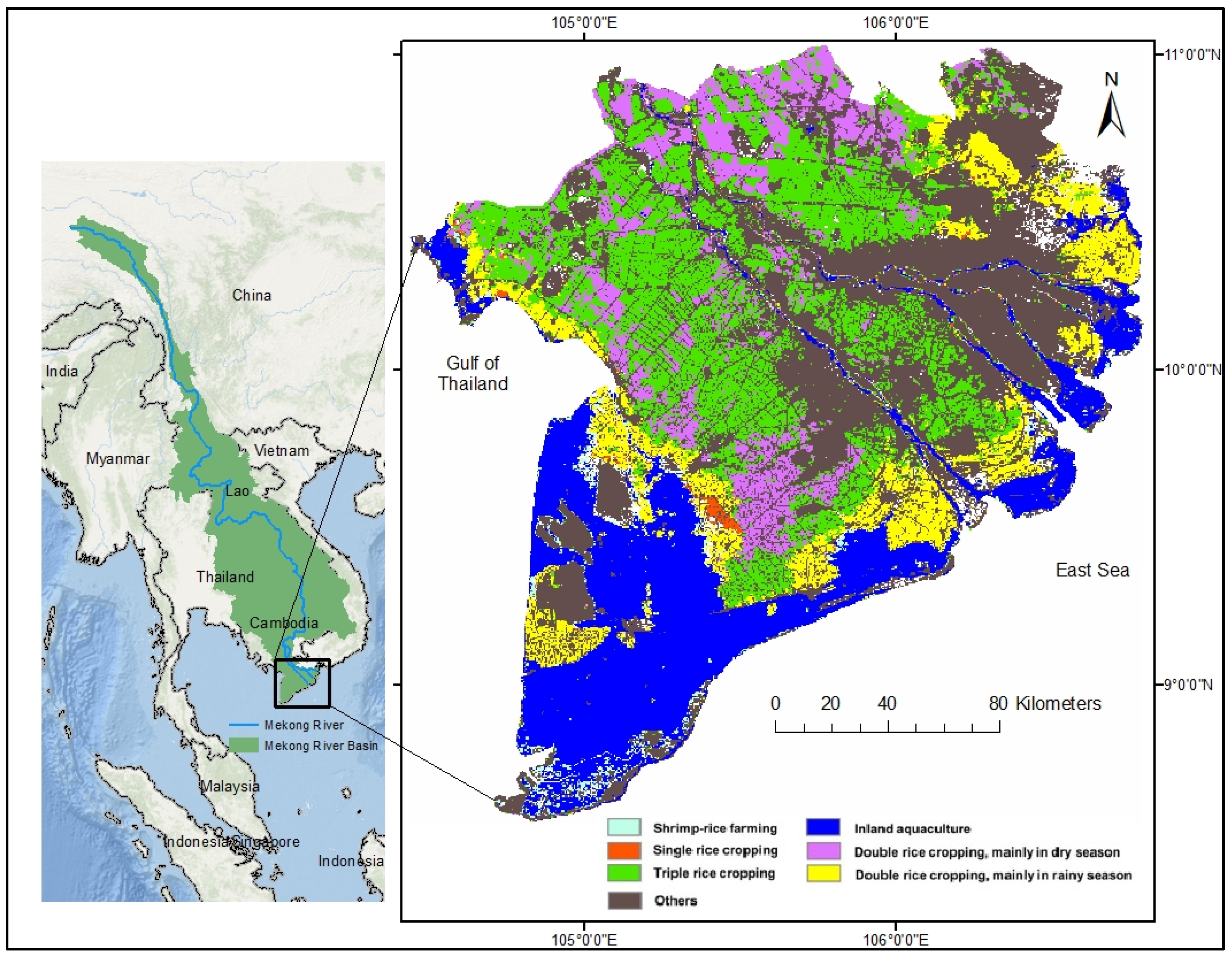
2.1. The Important Role of the Mekong Delta in the Global Rice Market

About 10% of the world’s population is estimated to live in lowland areas and river deltas [63]. The global scientific community has urgently called for actions to protect river deltas from SLR and greater risks from anthropogenic forces [15,18,60,64,65]. Recent studies have documented increasing risks of flooding and SWI in most of the world’s river deltas [16,60,64,66]. These emerging water challenges often require large-scale governmental interventions [17,67]. However, the effects of SWI in a mega delta such as the MKD, when interfaced with large-scale collective actions or government interventions, have received much less attention in the literature. Many reasons could explain the lack of studies on this issue. One of which is that government interventions are often considered too restrictive or crowd out existing norms [68], and there is a lack of legal frameworks guiding such interventions [67,69,70].
The Mekong River is the longest river in Southeast Asia, an important transboundary river that plays a major role in the economies of countries the river flows across, including China, Myanmar, Lao People’s Democratic Republic (Lao PDR), Thailand, Cambodia, and Vietnam. The river starts in the Tibetan Plateau, China, and empties into the East Sea (Figure 1). The MKD is a major rice producer [71], with the total amount of milled rice exported from this delta accounting for approximately one-sixth of the rice traded around the world annually [72,73]. Rice is a major staple food consumed by more than half of the world’s population [74].
The MKD is a lowland area with an average elevation of less than 1 m above sea level [75,76]; thus, the MKD is one of the world’s most vulnerable deltas to SLR and anthropogenic activities (e.g., hydropower dams) [16,17,18,77]. The MKD is a densely populated region with around 18 million inhabitants [72], and the third-largest river delta in the world [18,66]. Human activities (e.g., sand mining and hydropower development upstream of the MKD) and SLR have caused saline water to creep further into the MKD’s cropland areas [16,77,78,79,80]. These changes likely threaten not only the livelihood of the people in the MKD but also the food security of Vietnam and the world, which has a growing population [81,82].

2.2. Land and Water Management Policies Context in the Mekong Delta

To maintain the MKD’s ability to produce food for domestic use and export, the Vietnam Government (VNG) has been implementing numerous initiatives, primarily controlling flooding and SWI [16,77,83,84]. At the delta scale, hard policies (e.g., complex flood and SWI control infrastructure such as sluice gate systems) are more widely used to convey the freshwater around the MKD to enable agricultural, prominently rice intensification, e.g., triple rice cropping system [18,85,86]. The hard policies increase Vietnam’s rice production by some 110% from 1990–2024 [73], lifting Vietnam from a rice deficit to a rice surplus nation and becoming a major rice exporter in the world, only behind India and Thailand [73]. However, SLR and changes in the Mekong River flow likely substantially increase the hard policy’s costs, let alone the operation and maintenance of this hard infrastructure system [17,87], and risks locking the MKD into an unsustainable development trajectory [18,85]. Soft policies and nature-based measures to reduce the impacts of flooding and SWI are less popular. These include moving land away from rice monoculture, e.g., alternating rice with shrimp farming and reducing inputs (e.g., water) used to increase farmers’ income and better adapt to expectedly more severe and longer SWI [17,88,89]. Resolution No.120/NQ-CP issued by the VNG in 2017 aimed at fostering the use of climate-resilient and sustainable practices in the MKD [90]. The Resolution highlighted the urgent need to use nature-based approaches (e.g., land use control and planning and conservation irrigation such as alternate wetting and drying) to proactively increase the MKD’s ability to cope with environmental and water challenges facing the MKD. However, soft approaches have yet to be implemented at delta wide. In 2020, VNG established the Regional Coordination Council [91] to coordinate and develop guidance on the use of climate-resilient and sustainable practices that could be applied across the MKD.
Prior research showed that hard policies likely reduce SWI substantially under various SLR scenarios [16,17], but the costs of the hard policies were estimated to be expensive (approximately eight billion dollars) [17]. Some previous studies argued that reducing rice intensity and inputs used to grow rice (e.g., alternate wetting and drying, shifting triple rice to double or single rice production and/or land-fallowing in the upper, historical floodplain areas of the MKD, see Figure 1) would reduce the intensity of SWI [17,89,92,93] because the saved water can be stored and then released to control SWI during the Mekong River’s low flow periods. However, these soft and nature-based measures have only been implemented locally [89]. As a result, the extent to which these soft measures could reduce the intensity and risk of SWI under uncertainties regarding SLR and freshwater flow to the MKD remains poorly understood. An improved understanding of how and to what extent these soft and nature-based policies could alleviate SWI would help policymakers have better plans for protecting and moving the development trajectory of the MKD toward a more sustainable path. More importantly, maintaining the MKD’s ability to produce rice and export it to feed the world population contributes to food security for not only Vietnam but also the world.

2.3. Drivers and Trends of Saltwater Intrusion in the Mekong Delta

The sea level in the region was forecasted to rise by 22 cm and 53 cm in 2050 with the RCP 4.5 and RCP 8.5 scenarios, respectively, compared to 1986–2005 [94]. The total projected capacity of hydropower projects in the lower Mekong River Basin alone was 12,286 MW in 2020 and is expected to reach 30,344 in 2040 [95]. Previous studies showed that hydropower projects alter the natural flow and result in less sediment flowing to the VMD [16,77]. Higher sea levels and less sedimentation are likely to result in more severe SWI [16,17,77] and expectedly reduce the MKD’s ability to maintain the current rice production [18]. Table 1 summarizes SWI drivers.
It is well-documented that dams upstream of the MKD alter the natural flow and considerably decrease sediment flow to the MKD [67,77,97,103]. Less sediment in the MKD accelerated land subsidence and riverbed incision, which contributed to intensified SWI in the MKD [16,97]. In addition, dams increase the frequency of high-flow events but reduce the frequency of low-flow events [16,97]. Expectedly, these changes should reduce the severity of SWI in the MKD. However, recent research pointed out a drastic decline in flood pulse in the Cambodian floodplains located in the Mekong River and Tonle Sap Lake systems [16,98]. This change contributes to increased SWI in the MKD [16,31]. In general, previous studies indicated that SWI is likely intensified because of SLR and changes in the hydrological regime toward less stable river flow to the MKD in the dry season due to less water storage in the Tonle Sap Lake, which serves as a natural lake storing water in the wet (June–November) seasons and discharging the water to the MKD in the dry (December–May) seasons.
Numerous previous studies have analyzed SWI in the MKD due to its importance to food security in the developing world. Given the complexities of SWI in the MKD, these previous studies mostly used modeling approaches from a one-dimensional model (1D) [17,29,30,34,39,104], combined 1D-2D or semi-2D [105,106,107,108] to 3D models [16]. This previous study [54] reviewed an array of previous SWI-related studies conducted in the MKD. The literature showed that previous studies often simulate SWI and evaluate how and to what extent SWI driving factors intensity SWI in the MKD [54,86]. Thus, little is known about the costs of SWI and its mitigation strategies. Table 2 summarizes previous studies regarding drivers of SWI and its effects on the MKD. A more comprehensive review of previous relevant studies on SWI worldwide can be found in [14,45,54].
In general, two main conclusions can be drawn from the literature presented in Table 2. First, previous studies often focused on analyzing SWI drivers and the way in which and to what extent SLR increases SWI intensity [3,10,11,45]. Second, some recent studies attempted to quantify the costs of SWI (e.g., [12,59]), but these studies appear to overlook the effects of risk and uncertainties affecting the costs. Thus, little is known regarding the costs of SWI under the risk and uncertainty of these SWI drivers and the role these drivers play in SWI intensity. In addition, previous studies quantified the costs of SWI but appear to disregard the costs of SWI mitigation strategies under uncertainty. In this paper, we aim to address these two knowledge gaps. Specifically, we first develop an integrated modeling framework that integrates hydrodynamic and advection-dispersion with statistical and economic models to quantify these costs and their 95% confidence intervals. Then, we analyze how and to what extent these costs might increase or decrease due to SLR and mitigation strategies while accounting for the uncertainty of the Mekong River flow. This approach allows us to quantify the costs of SLR-induced SWI with and without SWI mitigation strategies. Such an approach provides quantitative trade-offs, which policymakers often need to make decisions with respect to SLR-induced SWI while accounting for risk and uncertainty. The framework might serve as a model for quantifying the costs of SLR-induced SWI under risk and uncertainties in other river deltas that face elevated SWI-related issues [21,22,23,110].

3. Materials and Methods
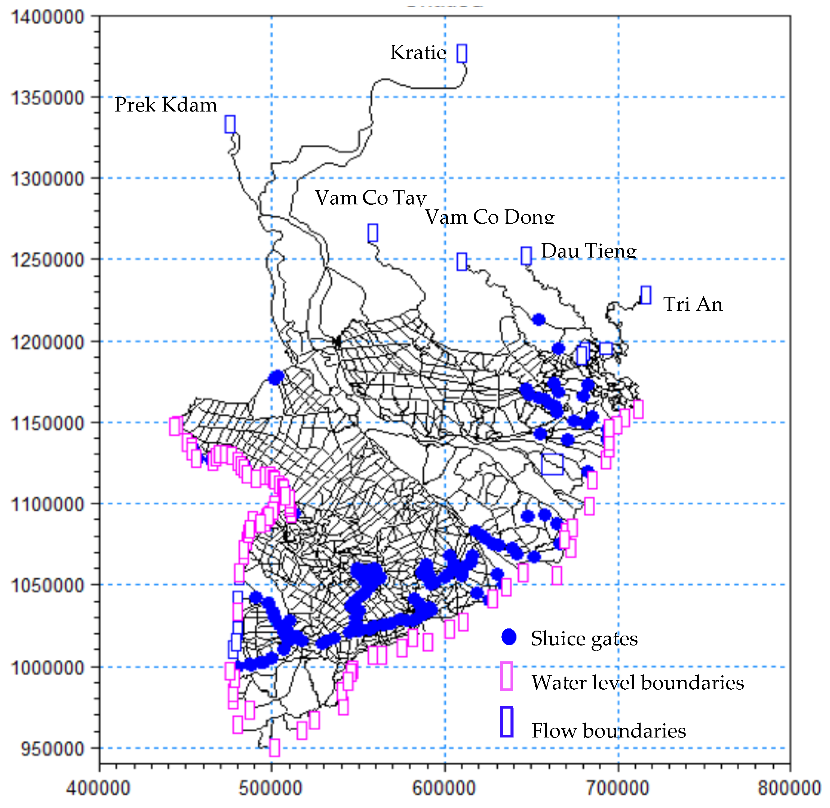
3.1. Study Area

Our study area is the MKD, which has two natural floodplains. One is located in the upper part of the MKD (Figure 1). The second floodplain is the Tonle Sap Lake, located in Cambodia. The two floodplains are considered two water storages by storing water in the wet (June–November) seasons and releasing the water back to the MKD in the subsequent dry seasons. The two floodplains play a key role in stabilizing water flowing to the MKD in the dry (December–May) seasons. In the last three decades, large parts of these two floodplains have been transformed into agricultural and urban lands. Dikes and flood control infrastructure were constructed, making two (even three in some areas) rice crops per year possible [85,89,111].
The MKD has monsoon climate conditions for two seasons. In the dry season, flows from the Tonle Sap Lake and the Mekong River are the two main sources of water. Flow in the dry season is much less compared to that in the rainy season. Farmers in the MKD rely heavily on surface water from rivers and canals for irrigation [112].
In this study, land-fallowing is defined as rice areas that are left uncultivated for one rice season in the upper MKD, where triple rice practice is the dominant one (see Figure 1). The fallowed land can be used to store water during the flood (wet) season. This stored water would then be released during the subsequent dry season for freshwater supply and SWI control in the coastal region of the MKD. This approach can be considered a nature-based approach for flood and SWI control since the upper MKD is a historical floodplain region. It was transformed into a rice-intensive producing region with complex hard infrastructure systems built for flood control in recent decades [85,89,113].

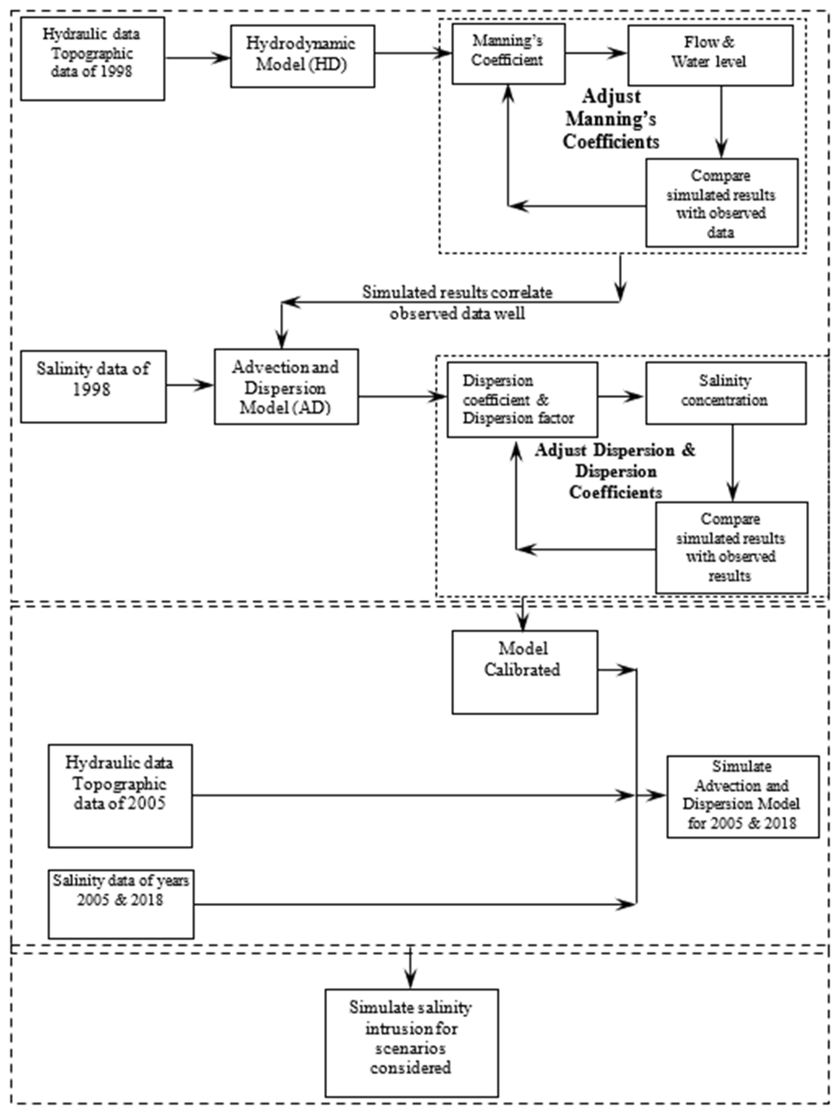
3.2. Modelling Procedure

Our integrated modeling framework consists of three steps, as shown in Table 3. In step 1, we use hydrodynamic and advection-dispersion models in the MIKE 11 software package to simulate 462 scenarios, which account for two SLRs, 27 Mekong River’s upstream flow, and seven land-fallowing scenarios (i.e., a baseline land use and six land-fallowing scenarios—fallowing 50 k–300 k with an interval of 50 k ha of one rice season in floodplain regions, and three AWD conservation irrigation scenarios (see Appendix A.7 for additional information on the AWD scenarios used). In step 2, we use MGF to characterize the distributions of SWI-impacted areas. Then, we apply Monte Carlo Simulation to quantify the probabilities associated with each scenario to account for the uncertainties of SWI under SLR, upstream flows, and mitigation strategies. We account for the uncertainty in SWI-impacted areas by constructing SWI distributions and estimate the 95% confidence intervals by the generated 10,000 simulated SWI-impacted areas. In step 3, we map these distributions and analytical crop yield models into an economic model to create a probabilistic economic model. The integrated model quantifies the economic costs and benefits of reducing SWI through land-fallowing and AWD conservation irrigation strategies while accounting for risks and uncertainties regarding SLR, the Mekong River flow, and SWI mitigation strategies. Table 3 lists all models used in the proposed integrated modeling framework.

3.2.1. Hydrodynamic and Advection-Dispersion Models

We used MIKE 11 version 2002, currently known as the MIKE+ Rivers model, developed by the Danish Hydraulic Institute. This model is an unsteady one-dimensional model with various modules, which can be used to simulate various physical processes in river systems [122]. We used a couple of Hydrodynamic (HD) and Advection-Dispersion (AD) modules to simulate SWI in the MKD. The river network used in this study has an eighty-two-time series of water levels at the downstream boundaries in the East and West Seas and a six-time series of discharge at the upstream boundaries. Two of which are located in the main Mekong River (Kratie and Prek Kdam). The upstream boundaries are inputted with time series river flow data, whereas time series water levels are provided to the downstream boundaries. This model is a refined version used in [29,30,34,39], which describes data and parameters, and calibration and validation processes with greater detail. In this study, we use a refined version of the model with the rivers’ cross-sections and all major saltwater control structures (sluice gates) collected until 2018 to improve the model’s performance. We re-validated the model with the data collected in 2018, observed SWI, and simulated SWI from previous studies. Appendix A.4 provides additional details about the model setup, data used, calibration and validation processes, and the model’s performance.

3.2.2. Moment Generating Function for Characterizing Distributions of SWI-Impacted Areas

We assumed that each SWI-impacted area, Xi, is an independent identically distributed (i.i.d) variable (i.e., a SWI event). Thus, a distribution for all n, taken from a population with a replacement for n times from a sequence of X1, X2, …, Xn has a mean, µ, and variance, σ2. Therefore, the sample mean, X ¯ , is calculated as, X ¯ = X 1 + X 2 + X n n . Thus, there are two scenarios regarding the distribution of the random variable, Xi, is that Xi either comes from a normal distribution or any other distribution.
Regarding the first scenario, if the sequence, X1, X2, …, Xn, has a mean, µ, and variance, σ2, from a normal distribution. The Moment Generating Function of any Xi is
M X 1 ( t ) = M X i ( t ) = = M X n ( t ) = exp μ t + 1 2 σ 2 t 2
because X1, X2, …, Xn come from the same population with mean, µ, and variance, σ2. Thus, they have a common MGF. The MGF of the sample mean, X ¯ , is expressed as,
M X ¯ ( t ) = M 1 n i = 1 n X i ( t ) = M X 1 n + X 2 n + + X n n ( t ) = M X 1 n ( t ) n
Given M a X ( t ) = M X ( a t ) , that Equation (2) can be re-written as
M X 1 n ( t ) n = M X 1 ( t n ) n
When Equation (3) is replaced by Equation (1), then
M X 1 n ( t ) n = exp μ t n + 1 2 σ 2 t n 2 n = exp μ t n + 1 2 σ 2 t 2 n 2 n = exp n μ t n + 1 2 n σ 2 t 2 n 2
M X 1 n ( t ) n = exp μ t + 1 2 σ 2 t 2 n
Equation (5) implies that the distribution of the sample mean, X ¯ , is normally distributed with a mean μ and variance σ 2 n .
Similarly, if the sequence, X1, X2, …, Xn, has a mean, µ, and variance, σ2, from a distribution other than a normal distribution, for all n, taken from a population with a replacement for adequately large times ( n 30 ). The distribution of the sample mean, X ¯ , is also normally distributed with a mean μ and variance σ 2 n [123,124,125]. Appendix A.3 provides proof of the theorem.

3.2.3. Monte Carlo Simulation for Statistically Quantifying SWI-Impacted Areas

We follow the proofs presented in the previous section to estimate distributions of SWI-impacted means. That is, we use simulated SWI-impacted areas to estimate means and variance because the distributions are normal distributions. Thus, we can compute all the statistics (e.g., 95% confidence interval of areas affected by SWI and their probabilities) needed with these two parameters. To empirically estimate the distributions of the mean SWI-impacted areas by scenarios, we apply the Monte Carlo simulation technique to estimate the means, standard error of the means, and 95% confidence intervals (CI) for the average SWI-impacted areas. We utilize the “boot” package in R [126] with 10,000 replications to accomplish the task.
Specifically, each simulated SWI-impacted area, denoted Ai, is an i.i.d variable (i.e., an event of SWI). A sequence of SWI events, A1, A2, …, An, has a mean, µ, and variance, σ2, from any distribution, for all n 30 , taken from a population with a replacement sampling technique. Therefore, the sample mean, X ¯ , is computed as, X ¯ = A 1 + A 2 + A n n . Sample means, μ X ¯ , and its variance, σ X ¯ 2 can be calculated as, μ X ¯ = μ and σ X ¯ 2 = σ 2 n , respectively [123,125].
As noted earlier, there are 27 simulated SWI-impacted areas for each scenario, which are associated with the data represented uncertainties (i.e., 27-year historical flow, one level of SLR, one level of water uses associated with each land use scenario). That is, each group scenario has 27 i.i.d variables, which are associated with 27 simulated SWI-impacted areas. Each group of scenarios has a mean of SWI-impacted areas computed as, X ¯ = A 1 + A 2 + A 27 27 , which is called a sample means. In this study, we are interested in estimating distributions of sample means for each scenario considered.
We can infer a distribution of SWI-impacted areas (by a particular scenario considered) as μ X ¯ = μ  and  σ X ¯ 2 = σ 2 27 . We create 10,000 sample means using sampling with replacement technique. We tested a larger sample means size (i.e., greater than 10,000), and found that a larger sample size increases simulation time but does not alter the results. Thus, we decided to select the sample means size of 10,000 for all of our Monte-Carlo simulations.
The probability, p, of average annual SWI-impacted areas, A, during a planning period with a pre-determined level of average annual SWI-impacted areas, Apre, can be estimated as a function of the sample means and its associated variance as
P ( 0 x A p r e ) = x = A A p r e f ( x / μ , σ 2 27 ) d x

3.2.4. Economic Model

Salinity reduces crop yield substantially. To quantify the effects of saline on rice crop yield, we rely on analytical crop yield models shown in Figure A3 in Appendix A.6 to estimate the yield effects due to SWI. We use an enterprise budget that accounts for crop yield, production costs, and prices to estimate the farm profits. Herein, we follow previous studies and assume that areas affected by saline concentration levels of 4 g/L or above would have zero profit (potential losses) [12,116].
To statistically compute the expected potential losses with and without mitigation strategies, we map the SWI-impacted probabilities into the potential losses. We also account for the efficiency ratio, ER, which reflects how many hectares need to be fallowed or adopted AWD to reduce SWI-impacted areas by one hectare. The potential farm profit losses, PFL, without mitigation actions (baseline) is calculated as
P F L = E R × L × P ( L )
where PFL is the expected farm profit losses, L is the potential farm profit loss due to SWI, and P(L) is the probability/likelihood of the loss. A potential farm profit loss is the function of production costs, crop prices, and crop yield. Appendix A.5 provides detailed information on the potential profits and losses per ha.
The expected potential farm profit losses with a mitigation strategy, PFLm, is calculated using a multiplicative equation that considers the efficiency ratio, ERm, expected potential farm profit losses with mitigation strategies used, Lm, likelihood of the loss, P(Lm), and costs of the mitigation strategy, Cm.
P F L m = E R m × L m × P ( L m ) + C m
Appendix A.5 provides more details regarding how the costs and farm profits are estimated.

3.2.5. Alternate Wetting and Drying Conservation Irrigation Practice Adoption Model

The marginal proportion of rice area using AWD irrigation practice is largely unknown because the practice is relatively new to farmers, and few studies have estimated the parameters associated with AWD diffusion in the MKD.
In this study, we follow [127,128] to estimate the marginal proportion of rice area that could be adopted in AWD irrigation practice in year t, MPt. The initial marginal proportion in year t0 (year one), MPt0, is given by:
M P t 0 = R a × R o × ( 1 R o C r )   for   t = 0
where Ra is the adoption rate, Ro is the beginning adoption level, and Cr is the ceiling adoption rate, which indicates the highest possible adoption rate of the AWD irrigation practice. From year two to the final year considered, the marginal proportion, M P t , is calculated as
M P t = R a × C p t 1 × ( 1 C p t 1 C r )   for   t = 1 T
where C p t 1 is the cumulative proportion in year t − 1. Table 4 shows the parameters used to estimate the marginal proportion.

3.3. Data Sources Used and Scenarios Considered in This Study

This study utilized data obtained from multiple sources. The primary sources included the Mekong River Commission (MRC), the Provincial Meteorological and Hydrological Departments (PMHDs) within the Mekong Delta, and the Southern Institute of Water Resources Research (SIWRR), Vietnam [129]. The MRC database provides data for selected years and temporal resolutions, with certain gaps attributable to historical conflicts in the region. Upstream flow data (e.g., Kratie and Prekdam stations) from the MRC are available for the periods 1961–1970, 1998, 2005, and 2010–2024 [130]. Downstream water level data for the years 1998, 2005, and 2018 were obtained from PMHDs. Additionally, daily water level and discharge data from eight key stations—Tan Chau, Chau Doc, Can Tho, My Thuan, Cao Lanh, Dai Ngai, My Tho, and Tra Vinh—were utilized for model calibration and validation for the years 1998, 2005, and 2018. Further details regarding the model structure, as well as the calibration and validation procedures, are provided in Appendix A.4.
Regarding the SLR scenario, we select RCP 4.5 and 8.5 emissions scenarios, described by the Intergovernmental Panel on Climate Change (IPCC), as moderate and high emissions scenarios. The two scenarios have SLR values of 22 cm and 53 cm, respectively. We selected these two scenarios because they were included in the “Climate change and sea level rise scenarios for Vietnam” report published in 2016 by the Ministry of Natural Resources and Environment, Vietnam [94]. The river network and its cross-sections also come from SIWRR for 1998 and 2005 [129], the SOBEK model for 2013, and the iMOD model for 2017 [131,132,133]. Appendix A.4 provides details about the model setup, data used, calibration and validation processes, and their performance.
To estimate the economic trade-offs between controlling SWI and farm profit losses. We rely on the farm’s net returns for two main farming practices in the MKD, including rice and shrimp farming. The data on rice yield and its price come from the General Statistics Office of Vietnam (GSO) [72] and analytical rice yield models for different rice varieties from [116]. We rely on previous studies to estimate production costs and revenues associated with rice and shrimp farming in the MKD [88,113,114,115,121,134,135,136]. Appendix A.5 provides detailed information on the potential profits and losses per ha.

4. Results and Discussion

4.1. Model Performance

The model shows good quantitative performance. Correlation coefficients between observed and simulated water level, river flow, and saline concentration were 0.82 or above. SWI in the MKD is a complex process [16,108]. The performance of the model indicates that the model is reasonably able to capture the process well in terms of magnitude, trends, and variation. Appendix A.4 provides additional information on the correlations between observed and simulated results for the hydrodynamic and advection-dispersion models.
As proof of the MGF showed in the methodology section, distributions of the mean of SWI-impacted areas by each scenario considered are approximately normally distributed regardless of the underlying distribution of each SWI-impacted area if the sample size is sufficiently large (n ≥ 25). It is worth noting that sample size is required to have the distribution of a sample mean being normally distributed, which is still subject to debate. Studies also indicated that the sample size should be no less than 30 [123,124,125]. Since each scenario considered in this study has 27 years of river flow data, we selected a sample size of 27. To ensure the distribution of SWI-impacted areas is approximately normally distributed, we follow a statistical test suggested by previous studies [123,124,125], and use q-q plots to test the normality of distributional SWI-impacted areas. Our results indicate that the distributions are normal distributions because most of the points fall on a 45-degree line (Figure 2). Thus, we can reasonably consider these distributions as normal distributions and compute probabilities associated with any given SWI-impacted area.

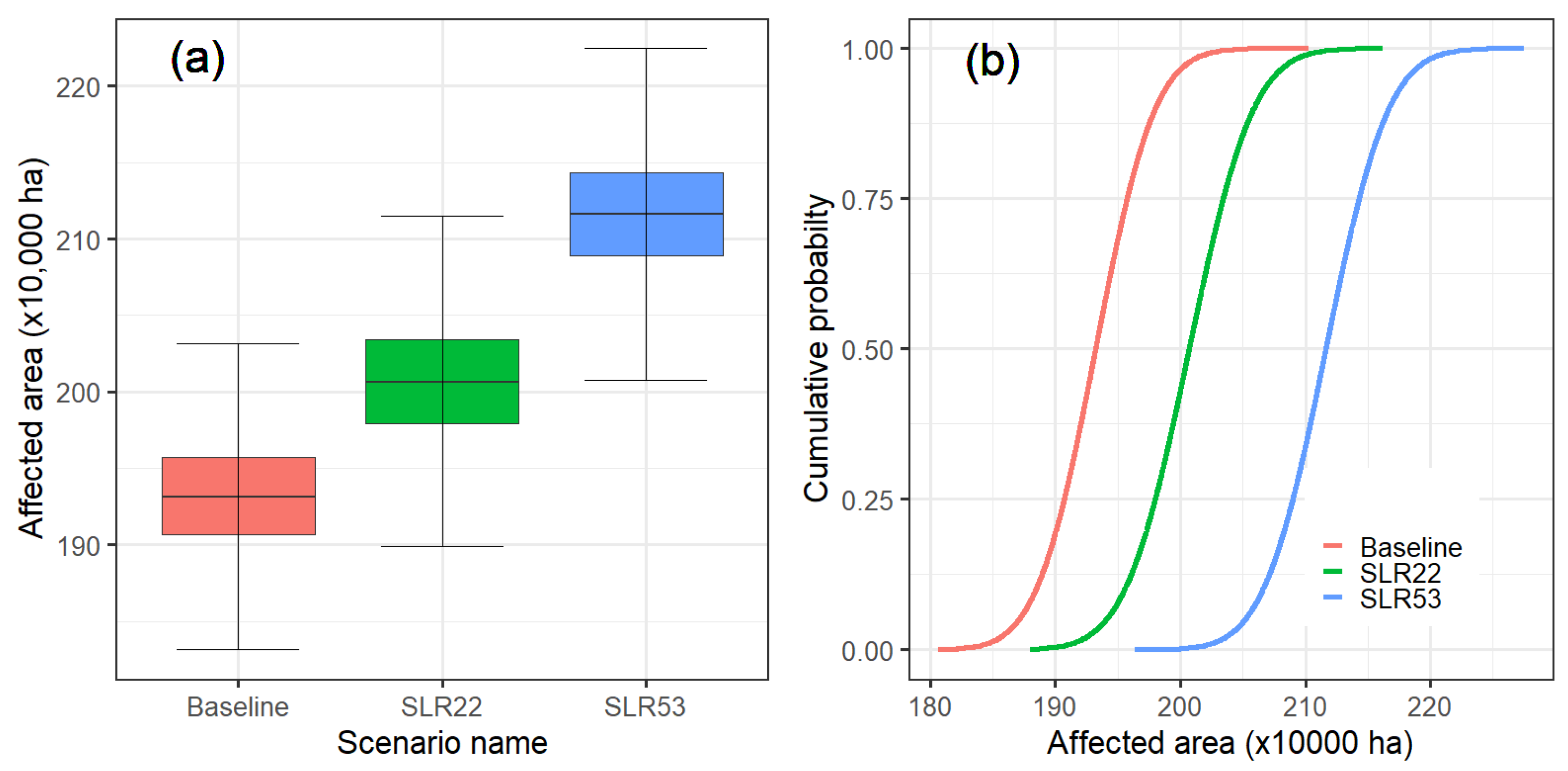
4.2. Estimated Distributions of SWI Means and Effects of Sea Level Rise on SWI Intrusion and Risk

Figure 3 shows the expected direction of the SWI-impacted areas (intensity) and associated probabilities (risk) under the effect of SLR. Three CDFs (panel (b)) are associated with three scenarios considered (baseline, SLR of 22 cm, and SLR of 53 cm). As proofed in the methodology section and q-q plots shown in the previous Section 4.1, annual means of SWI-impacted area distributions are approximately normally distributed. Thus, the mean (expected value) of SWI-impacted areas for each scenario is associated with the cumulative probability of 0.5 (i.e., half of the area under the bell curve). As expected, rising sea level shifts the distribution to the right, meaning the SWI is expected to be more severe. The expected SWI-impacted areas are approximately 1.93 with a 95% confidence interval of 1.86–2.01 million hectares (ha) for the baseline scenario, 2.01 with a 95% confidence interval of 1.93–2.09 million ha for an SLR of 22 cm, and 2.11 with 95% confidence interval of 2.04–2.19 million ha for an SLR of 53 cm, respectively. This implies that an SLR of 22 cm could lead to around 73,500 ha with a 95% confidence interval of 47,500–103,700 ha being additionally affected by SWI. A SLR of 53 cm would result in an additional 180,200 ha with a 95% confidence interval of 154,500–208,600 ha being affected by SWI compared to the baseline (no SLR) (see Table 5).
It is worth noting that the cumulative distribution function (CDF) curves for the two SLR scenarios are more spread out than that of the baseline scenario (Table 5), implying that the future SWI will likely have greater variability and higher risk. For example, CDF curves (Figure 3, panel (b)) show that the mean of the SWI-impacted area for the baseline is 1.93 million ha with a cumulative probability of 0.5, meaning that SWI would affect 1.93 million ha every other year (50% chance), but under SRL of 22 cm, the chance would be almost 100%. For this SLR scenario, the expected value of the SWI-impacted area would be approximately 2.01 million ha, which is almost equal to the maximum SWI-impacted area for the baseline scenario. The likelihood of an SWI-impacted area of less than or equal to 2.01 million ha is 0.5 for an SLR of 22 cm but only 0.03 for an SLR of 53 cm, meaning that an annual SWI-impacted area of being greater than 2.01 million ha would be extremely likely than not with an SLR of 53 cm. Under the present condition (the baseline), our results show that the likelihood of a SWI-impacted area of 200,650 ha is only 1-in-20 (see Table 5). These findings reveal that future SWI in the MKD will likely be much more intense and uncertain, posing a greater risk to the ability of the MKD to sustain its current level of food production.
Our findings complement previous findings in two major ways. First, our findings echo previous findings indicating that SLR increases SWI in the MKD substantially [16,17,29,34,107,109]. For example, [16] showed that SLR could increase the SWI-impacted areas by some 7% compared to the present-day (baseline) SWI level. Our findings agree with the finding from [16] and show that SLR could lead to an increase of expected (50% chance) SWI-impacted areas by approximately 4% and 9% for SLRs of 22 and 53 cm, respectively. The 95% confidence interval of these increases would be 2.5–5.4% and 8.0–10.8% for SLRs of 22 and 53 cm, respectively. Second, we enrich the literature by quantifying the SWI uncertainty. Previous studies (e.g., [16,17,29,34,36,107,109]) used a scenario-based approach to analyze the potential impacts of SLR on SWI; thus, they appear to focus on the increase in the intensity of SWI only and overlook the risk (likelihood) of SWI. Our method can estimate not only SWI intensity but also the likelihood associated with the intensity, thus allowing us to holistically account for the uncertainty of SWI. Future SWI intensity depends on uncertain hydroclimatic conditions and human responses, but little is known about the uncertainty of SWI [3,10,11]. Herein, we present an integrated framework for quantifying the uncertainty of SWI. This is especially important regarding quantifying the costs of SWI and its mitigation strategies [61,62].
Our findings have several substantial public policy implications for the livelihood of some 18 million of the MKD’s inhabitants as well as the international rice market. First, Vietnam is the world’s third-largest rice exporter [73], and most of the rice exported from Vietnam is grown in the MKD [137]. Significant rice production in the MKD would substantially impair Vietnam’s ability to maintain the current exported rice level. Less rice exported from Vietnam could increase the price of rice and, therefore, could have detrimental impacts on developing and rice-deficit nations [73,138,139]. Although we find that significant rice acreage in the MKD could be lost due to SWI if there are no effective mitigation actions, it is beyond the scope of our study to analyze how and to what extent the losses would affect the rice market in Vietnam and worldwide. This would be a fruitful research question. Second, the booming development of hydropower dams upstream of the MKD has altered water flow to the MKD [93,98,140,141]. Previous studies showed that dams increased water flow to the MKD in dry seasons [141,142]; thus, one would expect that SWI would be less severe with dams, but whether this is the case, and how and to what extent the impacts of these flow changes combined with SLR on SWI risk are unclear. Our proposed modeling approach has a statistical module that quantifies the extent of the effects of SLR on SWI while accounting for the flow variation. For example, as presented in Table 5, we find that the SLR of 22 cm would expectedly increase SWI-impacted areas by 73,500 ha with a 50% chance compared to the baseline, and there would still be a good chance of much higher SWI intensity, e.g., with 95% confidence interval of 47,500–103,700 ha. This finding highlights a substantial uncertainty surrounding the SWI, which likely makes mitigations and adaptations much harder and costlier. Our findings also echo the call from previous studies to emphasize the need to analyze SWI risk [61,62]. Third, we find that an SLR of 53 cm would cause a significant loss, with an additional 180,200 ha affected (Table 5). This loss accounts for around 14% of the total rice areas in the MKD. This scenario is not unrealistic since there is little progress with respect to greenhouse gas emissions reduction. Hydropower dams upstream of the Mekong River have altered not only water but also sediment flow to the MKD [93,98,140,141], which has accelerated land subsidence in the MKD with an average elevation of around 1 m above sea level [18,75]. Land subsidence was found to increase SWI [16,36]. The combined effects of SLR and land subsidence would make the scenario of an additional 180,200 ha of rice areas lost to SWI plausible. This finding indicates that livelihood transformations for the MKD inhabitants toward nature-based approaches at different speeds and scales would be needed to move the MKD toward a more adaptive and sustainable trajectory.

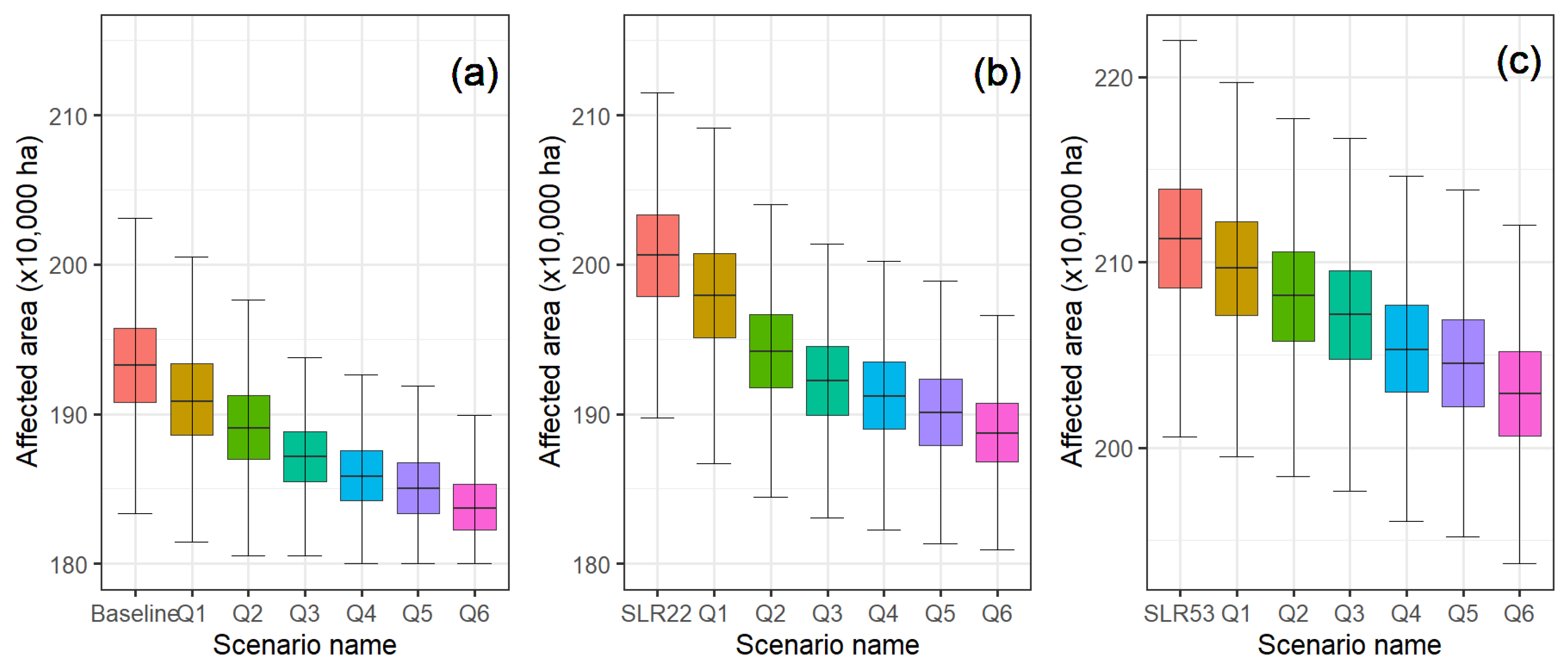
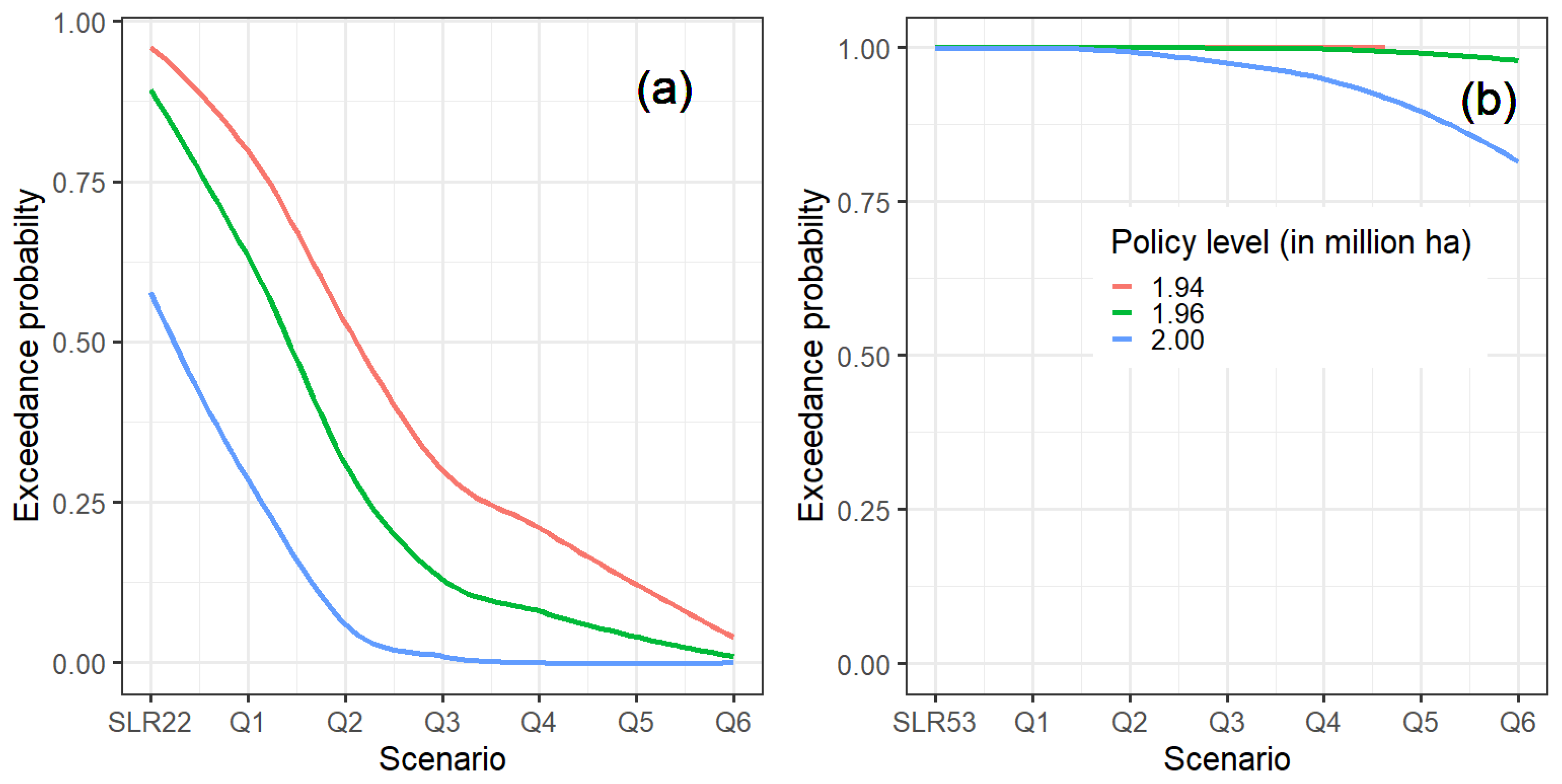
4.3. Combined Effects of Sea Level Rise and Land-Fallowing on Saltwater Intrusion Intensity and Risk

The effects of land-fallowing for one rice season on the SWI intensity and risk are illustrated in Figure 4. As noted earlier, in this study, we define land-fallowing as a practice that leaves rice uncultivated for one rice season in the upper part of the MKD, where the triple (three rice crops) practice is widespread (see Figure 1). The fallowed land can be used to store flood water during the wet season, and then the stored water can be released to the coastal regions of the MKD during the subsequent dry season for SWI control. As shown in panel (a) of Figure 4, land-fallowing can be very effective in reducing SWI intensity. For example, if no SLR is considered, land-fallowing can substantially reduce SWI intensity as well as risk, as shown in panel (a). The expected (mean) SWI-impacted areas are estimated to be around 1.93 million ha for the baseline, with a 95% confidence interval of 1.86–2.01 million ha. If 300,000 ha (Q6) of rice in the upper part of the MKD were to be fallowed for one rice season only, the expected SWI-impacted areas could be 1.83 million ha, which is around the minimum SWI-impacted under the baseline. Similarly, if SLR is accounted for, land-fallowing remains an effective approach for controlling SWI. Under an SLR of 22 cm, the 95% confidence interval of SWI-impacted areas is estimated to be 1.93–2.09 million ha. The results show that fallowing 300,000 ha of rice areas can bring down the expected SWI-impacted areas to around 1.88 million ha, which is lower than the minimum SWI-impacted areas under SLR of 22 cm (Figure 4, panel (b)).

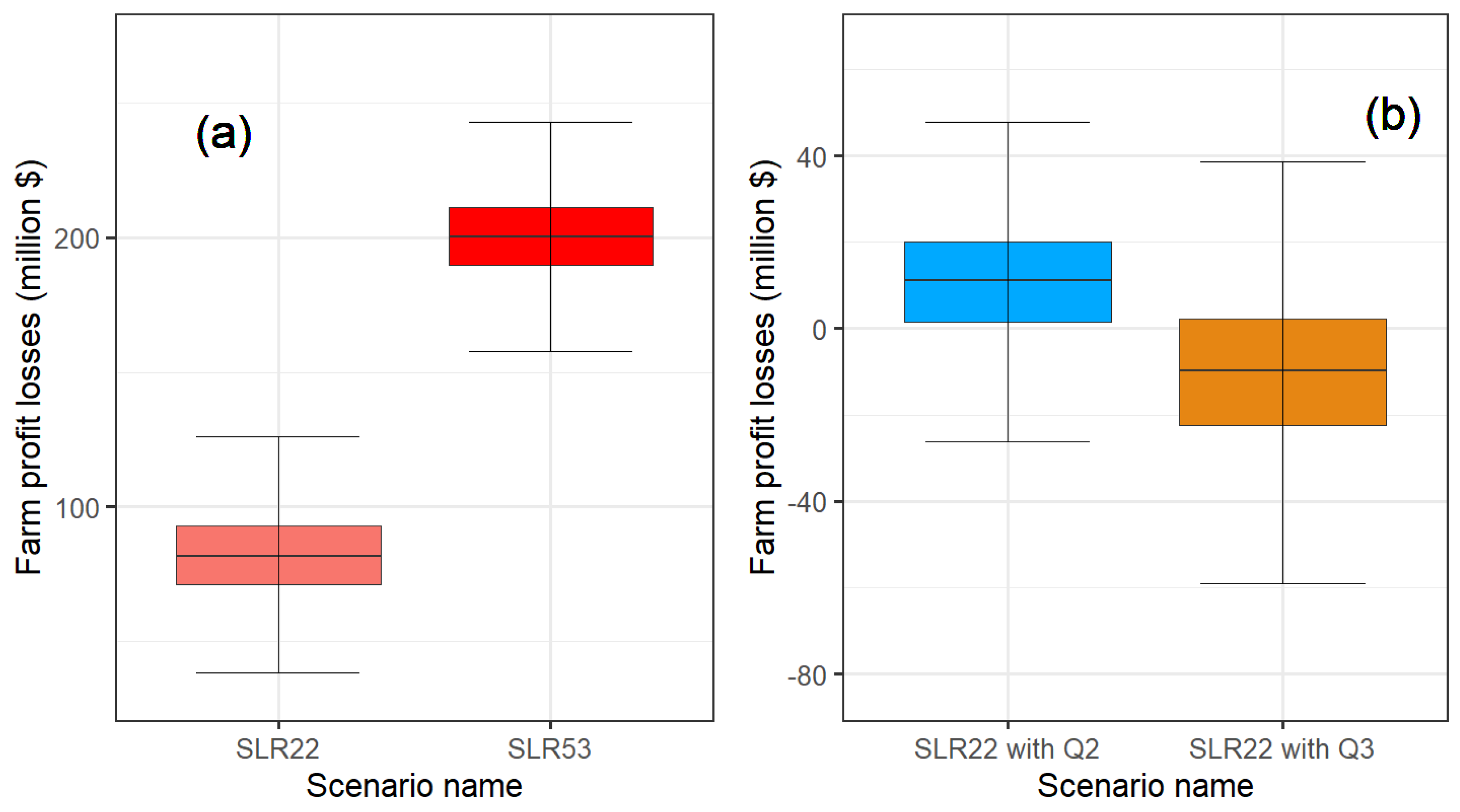
4.4. Costs of SWI Mitigation Strategies

Figure 5 illustrates the exceedance probabilities by SLR and land-fallowing scenarios. Herein, we define the policy level as the highest SWI-impacted areas that policymakers would tolerate. For instance, a policy level of 1.94 million ha means that policymakers would intend to maintain the SWI-impacted areas equal to or below 1.94 million ha. Thus, the higher the policy level, the lower the costs of SWI mitigation and exceedance probability, but the higher the farm profit losses. As shown in Figure 5, panel (a), if policymakers were to set the policy level at 2.0 million ha, the exceedance probability is estimated to be around 0.6, meaning that SWI-impacted areas would exceed 2.0 million ha for 6 out of 10 years with an SLR of 22 cm. Fallowing 150,000 (Q3) would be needed to bring this exceedance probability to close to zero. If the policy level were to be set at 1.94 million ha, this exceedance probability would be about 0.87, meaning SWI-impacted areas would be higher than 1.94 million ha for almost 9 out of 10 years considered, and fallowing 300,000 ha (Q6) would be required to bring the probability to close to zero. Under SLR of 53 cm, panel (b) shows that land-fallowing alone would not be enough to bring the SWI-impacted areas back to 1.94 million ha. This level is around areas affected by SWI that have historically been observed in the last two decades in the MKD [129].
Our findings reveal an important implication for using nature-based solutions to tackle the SWI problem in the MKD. We find that with a moderate SLR of 22 cm, the land-fallowing approach is very effective for reducing SWI intensity and risk; as shown in Figure 5, panel (a), the exceedance probabilities for all policy levels fall sharply, but this is no longer the case with SLR of 55 cm. Previous studies argued that nature-based approaches should be encouraged and incentivized to be adopted to steer the economic development path of the MKD toward a more sustainable trajectory [69,70,143,144]. Our study cautiously echoes this call. We find that a single nature-based approach might not be sufficient, even if adopted widely, to mitigate SWI under a high SLR scenario. This finding suggests that multiple approaches might be needed if a high SLR scenario appears to be on the horizon.
Figure 6 shows the potential losses of SLR-induced SWI without land-fallowing (panel (a)) and the losses compared to those without land-fallowing (panel (b)). That is, panel (a) illustrates the potential losses without mitigation action (land-fallowing), while panel (b) shows the potential losses with land-fallowing mitigation action compared to those without mitigation action. The SLR of 22 cm would cause an expected (mean) profit loss of $81.78 million, with a 95% confidence interval of $52.81–$115.37. A SLR of 53 cm increases the expected costs by some 145%, from $81.79 to $200.39. This striking finding shows that the minimum costs under the SLR of 53 cm are estimated to be much higher than the maximum costs under the SLR of 22 cm (panel (b)), indicating not only the magnitude of the SLR-induced SWI costs but also the potentially huge deviation of the costs under different SLR scenarios. As shown in panel (b), fallowing 100,000 ha for SWI control would have an additional potential loss of $11.18 million with a 95% confidence interval of −$17.96–$37.08 million compared to that without land-fallowing. This means that under the SLR of 22 cm, more than 100,000 ha would need to be fallowed to achieve the same losses that the SLR of 22 cm would cause.
It is worth noting that the losses shown in panel (a) of Figure 6 are the additional losses due to SWI induced by SLR. Saltwater intrusion currently causes hundreds of million of economic losses and disrupts the water supply for millions of people in the MKD every year [145,146,147]. Thus, we can interpret these losses presented in panel (a), Figure 6, as the losses of SLR-induced SWI. Note that the losses presented in panel (b) are computed with the efficiency ratio of 1, meaning that 1 ha in the upper part of the MKD needs to be taken out of production for one rice season to reduce 1 ha of the SWI-impacted area. As presented in Table 2, it is estimated that between 100,000–150,000 ha of rice in the floodplain regions needs to be fallowed for one season a year to reduce around 73,500 ha of rice areas affected by SWI, meaning that the hydrodynamic and advection-dispersion models imply that the ratio is between 1.36 and 2.04. Thus, land-fallowing could result in a negative net return (see Table 6) if no positive externalities (i.e., indirect benefits) of land-fallowing were to be considered.
Nature-based solutions often have multiple positive indirect benefits. The results shown in Figure 6 and Table 6 exclude indirect benefits that involve increases in sediment loads and soil fertility resulting from low-dike systems [114,119,148]. The higher sediment loads often lead to reduced bank erosion and fertilizer use, with a total benefit of higher sediment loads estimated at $1031.7 per hectare per year [119,148]. Another indirect benefit of SWI control that is overlooked is related to freshwater supply improvement. SWI causes widespread freshwater supply disruption [56,149]. It is estimated that households in the MKD were willing to pay around $36 per year to avoid water supply disruption due to SWI [56]. In drought years, SWI can cause water shortages for some 3 million people [149]. With a family size of 3.9 [137], this would translate to about 750,000 households in the MKD being affected by SWI every year. This means the benefits of improving water supply reliability through SWI control in the MKD would be around $27 million annually. As a result, even if the ratio is greater than one (i.e., fallowing more than one ha to reduce one ha affected by SWI) the land-fallowing can yield a positive net return if all indirect benefits are accounted for.
It is worth noting that if an SLR of 53 cm, land-fallowing alone would not be sufficient to bring down the SWI-impacted areas to the baseline, which is around 1.94 million ha annually [129]. As presented in Figure 5, panel (b), even if policymakers accept a policy level of 2 million ha per year, land-fallowing alone is still not an effective approach for SWI control. This means land-fallowing needs to be used in conjunction with other methods. Figure 7 shows the adoption rates of synthetic AWD conservation irrigation practices over time for the planning horizon of 2025–2050. Previous studies conducted in the MKD indicated that AWD irrigation practice reduces water applied for rice cultivation substantially by 40–50%, but maintains the crop yield compared to conventional flood irrigation practice [100,101,102]. AWD can even yield higher farm net return if the practice is used correctly [100,101,102]. Thus, increased AWD adoption can substantially reduce the water used for rice cultivation in the MKD’s upper regions at little cost to the farmers. The saved water could be stored and then released into the river to mitigate the SWI in the coastal regions of the delta. We assume that adopting AWD could reduce the water required for rice cultivation by 45% for the Long Xuyen Quadrangle and Plain of Reeds. The two regions had approximately 1.0 million ha of rice cultivated in summer-autumn 2021 [137]. Appendix A.7 provides details about the AWD diffusion scenarios and how and to what extent AWD can be used to control SWI.
A remote sensing approach was used to detect the AWD adoption rate in the MKD [150]. The author showed that the adoption rate is as low as 4% in the coastal provinces but as high as 68% in provinces in the upper part of MKD. This means that AWD diffusion associated with scenarios 1 and 2 likely reflects the AWD adoption rates over time in the coastal provinces, while scenarios 5 and 6 might reflect the AWD dynamics for provinces located in the upper part of MKD. Vietnam Government intends to use AWD for 0.5 million ha [94]. However, little is known about the future adoption rates of AWD. Thus, in this study, we set different adoption rate parameters so that the AWD adoption scenarios would result in the same amount of flow presumably released to the rivers compared with land-fallowing scenarios. This approach allows us to compare how and to what extent technology adoption could reduce farm profit losses due to SWI. We find that the adoption of AWD in the coastal provinces needs to be around 21% to be considered sufficient for bringing SWI to the baseline level under an SLR of 22 cm. For an SLR of 53 cm, fallowing around 300,000 ha in the upper part of the MKD and AWD adoption for some 280,000 ha (scenario 2 shown in Figure 7) would be needed to get the SWI-impacted areas back to about the baseline level. Given that the current adoption rate is relatively low [151], incentives are needed to boost the adoption rate of AWD, especially in the coastal regions of the MKD. Although it is beyond the scope of this study to analyze the way in which AWD adoption can be increased, previous studies find that technical support and financial incentives can increase technology adoption in agriculture [68,152,153,154,155,156,157,158,159].
In general, our findings reveal two important implications for using nature-based solutions to tackle SWI issues. First, we find that with a moderate SLR of 22 cm, the land-fallowing approach is very effective for reducing SWI intensity and risk. The exceedance probabilities for all policy levels reduce sharply, but this is no longer the case with the SLR of 53 cm (Figure 5a). We find that the 95% confidence interval of annual farm profit losses of an SLR-induced SWI under an SLR of 22 cm and 53 cm are between $52.81–115.37 million and $171.81-$231.96, respectively (Table 6). If land-fallowing were to be used to mitigate SWI under the SLR of 22 cm, the annual losses would be $100.03-$176.67 million. These losses are associated with a 50% chance of SWI-impacted areas, implying that the losses could be much higher but with lower probabilities. Previous studies argued that nature-based approaches should be encouraged and incentivized to be adopted to steer the economic development path of the MKD toward a more sustainable trajectory [70,144]. Our findings cautiously echo this call. We find that a single nature-based approach might not be sufficient even if adopted widely under a high SLR scenario. This finding suggests that the use of multiple nature-based approaches conjunctively might be needed if a high SLR scenario appears to be on the horizon. The second implication is regarding the costs of SLR-induced SWI. The exceedance probabilities drop sharply with the SLR of 22 cm but the SLR of 53 cm (Figure 5). This phenomenon likely indicates the nonlinear relationship between the costs of SLR and SWI, and more importantly, high SLR levels could substantially limit the effectiveness of some nature-based mitigation measures. This implication echoes the previous findings indicating that as SLR, the costs of adaptation rise non-linearly against the SLR [160,161,162,163,164]. Thus, a natural progression of our work is to establish the statistical relationship between SLR-induced SWI and its costs.
In addition, the results reveal that a holistic approach to tackling SWI in the MKD needs to be coordinated by all counties sharing the mighty Mekong River. Rapid hydropower development in the Mekong basin has altered the natural water and sediment flow of the Mekong River [93,98,140,142]. One would expect that hydropower dams would lead to higher flow to the MKD in the dry season; thus, SWI should be less severe, but recently observed SWI reveals that SWI is getting more severe and longer [16,31]. Our results point to another potentially adverse effect of rapid hydropower development: SWI in the MKD is much more uncertain. As shown in Figure 3, the distribution of SWI is not only shifted to the right but also wider, which indicates that the SWI likely has a larger variance. This finding calls for additional in-depth analysis of the potential short- and long-term effects of hydropower development upstream of the mighty Mekong River on not only average hydrological and ecological indicators (e.g., water level, flow, and SWI) but also their variations across the Mekong River Basin.
The SWI issue in the MKD has been worsening due not only to activities outside the boundary of the MKD but also activities inside the MKD. Within the MKD, illegal sand mining and over-use groundwater were found to contribute to increased SWI [16,141,165]. Thus, reducing the use of sand mining within the MKD and/or switching to other alternative materials for house and road construction is encouraged to reduce riverbed incision [33,70]. Reducing groundwater use by improving surface water supply [166,167,168,169] and groundwater conservation through managed aquifer recharge (MAR) [170,171,172,173,174,175,176]. Adaption measures such as shifting from rice farming and mangrove lands to water-saving crops, aquaculture, conservation practices [155,177,178,179], and other salt-tolerant crops can improve the long-term viability of communities in many parts of the MKD [9,42,70]. Previous studies find that farmers often require technical and/or financial incentives to adopt technology [68,180,181]. A fruitful future research direction would be to study the ways in which new farming practices can be encouraged to ease the effects of SWI.

5. Conclusions

We develop an integrated model by integrating physical process-based, statistical, and economic models to quantify the extent to which a soft policy can reduce the intensity and risk of SWI in the third largest Delta in the world, the MKD. The analysis could help policymakers to have an overall picture of the SWI under uncertainty and the costs and benefits of potential soft, nature-based planning policies for controlling SWI in the MKD. We find that SLR increases SWI substantially. By 2050, a moderate SLR of 22 cm will likely increase SWI by approximately 73,500 ha, with 95% confidence intervals of 47,500–103,700 ha. If the sea level were to rise by 53 cm by 2050, our model shows that an expected (50% chance) additional 180,200 ha of rice areas would be affected when compared to the baseline. This SWI-impacted area accounts for roughly 14% of total rice areas in the MKD, a major rice-producing region in the world. We find that the 95% confidence intervals of potential annual farm profit losses of an SLR-induced SWI under an SLR of 22 cm and 53 cm are between $52.81–115.37 million and $171.81-$231.96 million, respectively. A land-fallowing policy alone could be used to effectively mitigate these losses associated with the SLR of 22 cm. Under the SLR of 53 cm, land-fallowing, and AWD likely need to be used conjunctively to take the SWI back to its baseline level. Our results also indicate that SWI is expected to be intensified and more uncertain—the distributions of future SWI are likely to shift rightward and wider, implying a greater risk of profit loss for farmers in the MKD. The results imply that the MKD would be on a more sustainable developmental path with cooperative rather than competitive development plans [18,67,77].
Regarding the effectiveness of nature-based policies to control SWI, we find that land-fallowing alone is likely adequate to control SWI with 22 cm but 53 cm of SLR. Widespread use of both land-fallowing and AWD conservation irrigation practices is needed to bring the SWI back to the baseline under an SLR of 53 cm. An economic analysis of the policy implies that the economic benefits of a policy depend on the number of hectares that need to be fallowed one season a year to reduce one hectare affected by SWI, meaning that the larger storage capacity of a unit of land being fallowed, the more effective of the land-fallowing policy in term of SWI mitigation. It is worth noting that our simplified economic analysis overlooks many costs and benefits associated with the policy (e.g., water supply and soil health benefits). Thus, a fruitful future study would be to quantify these costs and benefits to provide a better understating of the policy. Still, our analysis provides essential information on the future SWI, as well as a trade-off associated with soft land use planning and nature-based policies. As a result, our study provides valuable information regarding the costs and benefits of soft, nature-based policies to support more sustainable delta-wide development plans.
We limit the effects of the errors on our findings by employing a statistical approach to quantify the impacts of SLR on SWI under the uncertainty of the Mekong River flow and SLR. Still, the findings should be interpreted with caution. The lack of information on the prevalence of ill-legal sand mining, groundwater use, and the effects of sediment flow due in part to hydropower dams is likely to limit the study’s ability to fully account for how these factors might affect SWI dynamics in the MKD. Thus, a further study could assess the long-term effects of these factors on future SWI intensity and risk and to what extent these factors would affect rice production and livelihood of the farmers in one of the major rice production regions of the world.
Recent studies showed wide ranges of SLR projections depending on assumptions and models used [182,183]. We select two SLRs associated with RCP 4.5 and 8.5 emissions scenarios. This selection is due to the simulation time. As noted, we simulate 462 scenarios, and each scenario takes about 8 h to run. Accounting for more than two SLR scenarios would increase the simulation time substantially. Future studies can first build confidence in SLR projections and then incorporate these projections into our approach to account for the effects of uncertainty in SLR projections on SWI. In addition, though we use a process-based model to simulate SWI, given the complexity of SWI in the MKD, long simulation time poses a challenge for analyzing a large number of scenarios. Machine learning (ML) has proved its potential to improve decision support systems in an array of fields, including water resources. Thus, future studies could utilize process-based models and ML techniques to forecast SWI for a large number of scenarios, which is likely to increase our understanding of SWI uncertainty and risk.

Author Contributions

D.Q.T.: Conceptualization, Methodology, Software, Data curation, Visualization, Investigation, Validation, Writing—Original draft preparation; K.N.L.: Conceptualization, Methodology, Data curation, Investigation, Validation, Writing—Reviewing and editing. All authors have read and agreed to the published version of the manuscript.

Funding

This research received no external funding.

Data Availability Statement

The authors do not have permission to share all data. A large portion of the data used in this study are available to the public, accessible from https://zenodo.org/record/4771261#.ZDWID-bMKUk (accessed on 12 May 2020) and https://portal.mrcmekong.org/home (accessed on 16 May 2020).

Acknowledgments

Any opinions, findings, conclusions, or recommendations expressed in this material are those of the author(s) and should not be construed to represent any official Office of Economic and Demographic Research, Florida Legislature, or U.S. Government determination or policy. No official endorsements should be inferred.

Conflicts of Interest

The authors declare no conflicts of interest.

Appendix A

Appendix A.1. Proposed Nature-Based Solution for Saltwater Intrusion Control in This Study

Resolution 120 provides a legal framework for nature-based policies aiming at increasing the use of climate-resilient sustainable practices in the MKD. The Resolution highlights the need to incorporate nature-based adaptation approaches like flood-based farming systems in floodplain regions and rotating rice with shrimp in coastal areas [90]. These nature-based practices can include: (1) strengthening the flood retention capacity of the floodplains (upper parts of the MKD) while minimizing the environmental impacts through natural-based approaches such as converting rice-cultivated land protected by high dikes to low dikes and (2) transitioning from triple rice to single or double rice production and other adaptive cropping systems.
Regarding AWD, it can save 40–50% of the water required to grow rice and has little impact on rice yield [100,101,102,184]. The saved water, thus, can be stored and then released to the coastal region of the MKD to mitigate SWI. The total amount of water that can be saved through adopting AWD is equal to the water applied per hectare (ha) multiplied by the total rice area adopted by the technology [100,101,102,127,128,184]. The amount of water that can be saved is presented in Appendix A.7. The total rice area that could adopt the technology is estimated using a logistic growth equation determining the marginal proportion of rice area under AWD [127,128].

Appendix A.2. The List of Hydrologic, Climate, and Water Demand Management Scenarios Considered

It is important to highlight that in our consideration of these nature-based policy scenarios, we operate under the assumption that they are both feasible and socially acceptable. Our intention is not to address the social dimensions associated with land and water sustainability, including individual or social behavior or agency representation. Nevertheless, the analysis enables us to derive policy implications for the quantitative formulation of local sustainability plans and the comprehensive assessment and regulation of such plans across the MKD. This proves valuable in light of the numerous uncertainties inherent in these assumptions. As noted in the main text, in this study, we do not consider land subsidence and riverbed incision scenarios; thus, we emphasize our analysis of the extent to which SLR affects the SWI in the MKD and how nature-based solutions (i.e., AWD and land-fallowing) can play a role in mitigating the effects of SLR on SWI. Previous studies indicated that land subsidence and riverbed incision play a significant role in intensifying the SWI [16,78,185]. Recently, the Vietnamese Government has taken steps to control land subsidence and riverbed incision, e.g., reducing illegal sand mining and allowing the use of sea sand for construction [165,186].
Table A1. Hydrologic, climate, and water demand management scenarios considered.
Uncertainty ClassificationSource of
Uncertainty
Scenario’s DescriptionSource
StatisticalUpstream flow27 scenarios: (based on) 27 years of historical upstream flows[130]
DeepSea level riseThree scenarios: baseline, RCP 4.5 and RCP 8.5 [94]
DeepWater demand within the MKDSeventh scenario: (based on) seventh potential seasonal land-fallowing scenario (i.e., reducing one rice season). These scenarios include a baseline land use and six land-fallowing scenarios, which can reduce the water use by the amount being equal to the total water used for 50,000 (Q1) to 300,000 (Q6) ha of rice, with an interval of 50,000 ha.Hypothetical land uses control scenarios introduced by the authors.
DeepWater demand within the MKDThree scenarios: these scenarios are based on theoretical conservation irrigation adoption practice adoption [127,128]. As noted in Appendix A.7, the total area under the AWD irrigation technique is estimated to be equal to 0.6 million ha, which can reduce the water use by 45% compared to conventional (continuous) flooding [100,101,102,184]Authors’
computation

Appendix A.3. Proof Regarding the Normality of the Distribution of the Means

We follow [187] to prove the distribution of the means of a sequence of independent random variables is normally distributed. Let X1, X2, …, Xn is a sequence of independent random variables with a mean of zero and variance of σ 2 the distribution function F and moment-generating function (MGF) M defined in a neighborhood of zero.
G n = i = 1 n X i   then lim x P G n σ n x = Φ ( x ) , < x <
Let Z n = G n σ n . We show that the MGF of Gn is the MGF of a distribution with a mean of zero and variance of 1, meaning that the distribution of MGF of Gn is a standard normal distribution. Given Gn is the sum of Xi, the MGF would be
M G n ( t ) n = M ( t ) n   and   M Z n ( t ) = M t σ n n
G ( s ) has a Taylor series expansion of about zero:
G ( s ) = G ( 0 ) + s G / ( 0 ) + 1 2 s 2 G / / ( 0 ) + ε s
ε s s 2   0 as s 0. Since E ( X ) = 0, G / ( 0 ) = 0, and G / / ( 0 ) = σ 2
As n  , t σ n 0 , and M t σ n = 1 + 1 2 σ 2 t σ n 2 + ε n
  • where ε n / t 2 n σ 2 0 as n 0 . Then, M Z n ( t ) = 1 + t 2 2 n + ε n n
If a n a then lim x P 1 + a n n n = e a . Thus, M Z n ( t ) = e t 2 2 as n  .
Because M Z n ( t ) = e t 2 2 is MGF of the standard normal distribution, the distribution of G n = i = 1 n X i is normally distributed.
As a result, the distribution G n n = i = 1 n X i n is also normally distributed.

Appendix A.4. Calibration and Validation Results

Figure A1 presents a conceptual flow diagram outlining the calibration and validation processes of the MIKE 11 model. The initial calibration and validation were conducted using data from 1998 and 2005, as documented by [29,34,39]. To enhance the model’s accuracy, we further refine it using more recent data collected up to 2018. Consequently, we re-validate the model using data gathered in 2018. This particular year is chosen due to the availability of more comprehensive saltwater data compared to the most recent year in our dataset.
Figure A1. Illustrative flowchart depicting the calibration and validation procedures of the MIKE 11 model. Source: [29,34,39].
Water 17 01355 g0a1
We use two modules, i.e., the Hydrodynamic (HD) and Advection-Dispersions (AD) modules, in the MIKE 11, to model the SWI in the MKD. The HD module needs two groups of inputs: (i) the configuration and dimensions of the river network and infrastructures and their operation procedures used to manage water dynamics, such as sluice gates (Figure A2), and (ii) water levels and flow/discharge time series, and initial boundary conditions for locations shown in Figure A2. To account for sea-level rise (SLR), we follow a widely adopted approach [16,29,34,39] by increasing the boundary conditions at downstream points by 22 cm and 53 cm.
Figure A2. River Network and boundaries used in the MIKE 11 model. Source: Southern Institute of Water Resources Research [29,34,39,129].
Water 17 01355 g0a2
In the Advection-Dispersions (AD) module, we set zero salinity concentrations at six upstream discharge boundaries. We input a time series of salinity concentration for downstream boundaries. We set the model with a time step (Δt) of 2 min and a maximum horizontal grid space (Δx) of 750 m, with cross-sectional profiles at 1 km–3 km. The model also accounts for how and to what extent saline control structures affect SWI by inputting all major sluice gates. Primary inputs for the model come from the MRC and hydro and saline stations managed by the PMHDs and the SIWRR [129].
The HD module is calibrated by adjusting model parameters, such as Manning’s coefficient, within experimentally determined ranges reported in the literature. This calibration process continues until the simulation outcomes closely align with observed data at multiple stations along the Mekong and Bassac Rivers. The calibration results indicate Manning’s friction values ranging from 0.03 to 0.018. The simulated outputs (water level and discharge/river flow) from the HD module exhibit strong agreement with observational data, with all correlation coefficients between observed and simulated results exceeding 0.85.
The calibrated AD model has AD coefficients ranging from 700 to 300 m/s2 for the Mekong River and 125 to 50 for other rivers in the MKD. Generally, the calibration of the AD module is much more challenging than that of the HD model because various factors affect the SWI, e.g., monsoon wind and temperature and operation sluice gates. The AD model is sensitive to AD coefficients. The availability of saline concentration observations is another factor contributing to the challenge we face while calibrating the AD model. For example, the salinity data for calibration in 1998 were not continuously measured and were observed during high tidal times [29,34,39]. The model AD generally simulates SWI with acceptable accuracy, as indicated by correlation coefficients exceeding 0.82. We validate the HD and AD models against data collected in 2005 and 2018. The results show that both models achieve acceptable results, with correlation coefficients ranging from 0.81 to 0.86 for both HD and AD modules.
In accordance with institutional policies, the data are available upon reasonable request for non-commercial use through a restricted-access repository. Certain observed water level, discharge, and salinity gauge data utilized in this study can only be accessed through a formal request and approval process by the Southern Institute of Water Resources and Planning (SIWRP) in Ho Chi Minh City, Vietnam (https://zenodo.org/record/4771261#.ZDWID-bMKUk, accessed on 12 May 2020). While some water level, flow, and salinity concentration data have been recorded at hourly or daily intervals, the presented data are aggregated at daily (without specific dates), monthly, and/or yearly resolutions to comply with the policies of state and local agencies. Flow data are available through the Mekong River Commission (https://portal.mrcmekong.org/home, accessed on 16 May 2020). For land subsidence data, readers are referred to the original publications [81,132,183,186].

Appendix A.5. Farm Profits

Soft policy (nature-based) costs or profits are largely related to the net return of rice production in floodplain and coastal regions [85,89]. The net return for one hectare of rice in the region is estimated at $1112.15 [88,136]. Losses due to SWI are estimated based on its direct impact on rice yield. Nhan, Phap [116] demonstrated a 50% reduction in yield with conventional rice varieties, whereas salt-tolerant rice varieties experienced significantly less reduction. Adoption rates of salt-tolerant rice varieties vary spatially and temporally across the MKD [188], and survey data were often employed to estimate losses equivalent to the benefits of salinity avoidance.
Table A2. Costs and returns for scenarios considered.
DescriptionProfit/Benefit
(U.S. Dollar)
Source
Annual sediment benefits and lower fertilizer needs$1,031.7/ha[114,119,148]
Rice production in the coastal region$1,112.15/ha[114,115,189]
Water supply benefits$36 per year per household[56]
The benefits of the nature-based policies include both direct and indirect benefits. Ref. [115] estimated that the farm profit in the coastal area was 1112.5 per ha. Indirect benefits involve increases in sediment loads and soil fertility resulting from low-dike systems [17,65,115,116,117,118,119,120,121,122]. The higher sediment loads often lead to reduced bank erosion and fertilizer use, with a total benefit of higher sediment loads estimated at $1031.7 per hectare per year [120,122,135,136]. It is estimated that households in the MKD were willing to pay around $36 per year to avoid water supply disruption due to SWI [56].

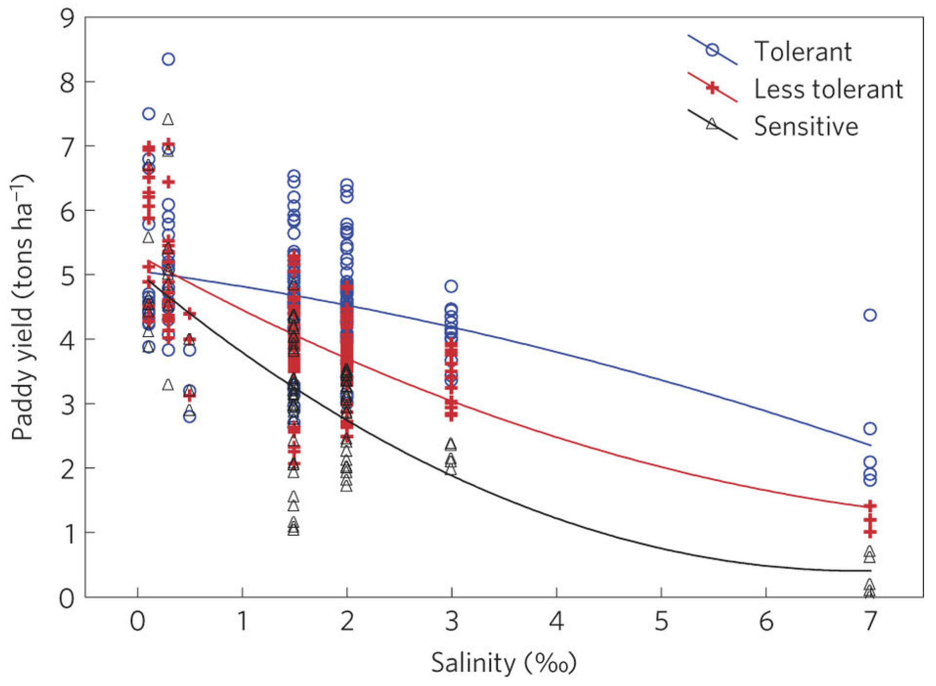
Appendix A.6. Paddy Yield in the Coastal Areas of the Mekong Delta by Saline Concentration Levels

Figure A3. Effect of saline concentration levels on paddy rice yield by different rice varieties. Source: [116].
Water 17 01355 g0a3

Appendix A.7. Total Water Applied for Rice Irrigation

The water demand for one season of paddy rice in a typical climate year is 573.5 mm, and farmers in the MKD typically flood the fields for approximately 60 days [190]. The return flow coefficient is 0.5 [191]. Therefore, the total water applied per hectare for one rice-growing season with conventional (continuous) flooding (CF) irrigation is calculated as
573.5 × 10,000 × 0.5 1000 = 2867.5   m 3
If rice areas in the upper part of the MKD were to be fallowed, i.e., reducing rice intensity by cultivating double rice instead of triple rice, more water could be stored during the flood/wet season; then the stored water could be directed to the coastal regions for SWI control and water supply. To model the impact of reduced rice intensification scenarios, we adopt an approach commonly used in prior studies [89,111], converting the stored water into flow released to the rivers in the delta. In this study, six land-use change scenarios involve reducing the rice season for a range of 50,000–300,000 hectares, with intervals of 50,000 hectares (refer to Appendix A.1 for additional supporting information on these reductions). Table A3 outlines the corresponding conversions. For instance, if one less rice season for 100,000 hectares were implemented in the upper part of the MKD, the reduced and stored water used would be released into the river at a rate of 55.3 m3/s, as calculated below.
W R = 2867.5 × 100,000 60 × 24 × 3600 = 55.3   ( m 3 / s ) 55   m 3 / s
It is worth noting that this estimation could be conservative. The upper part of the MKD can store a much larger amount of water, but storing a large amount of water would pose a risk of delaying the next rice-growing season in this region. In addition, if stored water could not be released on time, the region would risk a more severe flood in the subsequent year.
Table A3. Water reduced by soft land-fallowing scenario.
ScenarioReduced Rice Areas (ha)Equivalent Flow Released to the Rivers (m3/s) for Rice Area Under Conventional Irrigation
150,00027.6
2100,00055.3
3150,00083.0
4200,000110.6
5250,000138.3
6300,000165.9
Previous studies conducted in the region indicated that AWD irrigation practice reduces water applied for rice cultivation substantially by 40–50%, but maintains the crop yield compared to CF irrigation practice [100,101,102,184]. AWD can yield higher farm net return if the practice is used correctly [100,101,102,184]. Thus, increased AWD adoption can substantially reduce the water used for rice cultivation in the delta’s floodplain regions at little cost to the farmers. The saved water could be released into the river to mitigate the SWI in the coastal regions of the delta. We assume that adopting AWD could reduce the water required for rice cultivation by 45% for the Long Xuyen Quadrangle and Plain of Reeds. The two regions had approximately 1.0 million ha of rice cultivated in summer-autumn [137].
The marginal proportion of rice area using AWD irrigation practice is largely unknown because the practice is relatively new to farmers, and few studies have estimated the parameter. Here, we follow [127,128] to estimate the marginal proportion of rice area that could be used in AWD irrigation practice in year t, MPt. The initial marginal proportion in year t0, MPt0, is given by:
M P t 0 = R a × R o × ( 1 R o C r )   for   t = 0
where Ra is the acceptance rate, Ro is the initial adoption rate, and Cr is the highest adoption rate, which indicates the highest possible proportion of the landscape that could use the AWD irrigation practice. From year two to the final year, the marginal proportion, M P t , is calculated as
M P t = R a × C p t 1 × 1 C p t 1 C r   for   t = 1 T
where C p t 1 is the cumulative proportion in the year, t − 1. Table A4 shows the parameters used to estimate the marginal proportion.
Table A4. Water reduced by conservation irrigation practice scenario.
ScenarioRaRoCrEquivalent Hectares Fallowed for One Rice Season (ha)
10.100.100.18100,000
20.150.100.28150,000
30.200.100.55300,000
40.250.100.65400,000
50.300.100.80450,000
60.350.101.00550,000
Table A4 indicates the values for the adoption rate parameters used in this study. Scenario 1 likely reflects the prevalence of AWD adoption in the MD in the near future, while scenario 2 could indicate the adoption rate of AWD in the MKD in the medium term. Vietnam’s government intends to use AWD for 0.5 million ha [94]. Previous studies indicated that AWD adoption is expected to rise faster in Vietnam than in other major rice producers because Vietnam has well-organized farmer cooperatives [100]. However, little is known about the future adoption rates of AWD. Thus, in this study, set the adoption rate parameters so that the AWD adoption scenarios would result in the same amount of flow presumably released to the rivers with the land-fallowing control scenarios. This approach allows us to compare how and to what extent technology adoption could reduce the economic losses of SWI.

Appendix A.8. Selected Recent Saltwater Intrusion Studies in Asian Mega Deltas

The SWI has wreaked havoc in many Asian mega deltas. Ref. [23] used the FVCOM model to analyze how and to what extent river discharge and SLR affect SWI in the Ganges-Brahmaputra-Meghna delta. The findings showed that river discharge and SLR significantly affected SWI intensity. Similarly, Ref. [20] utilized the Delft3D and Delf Dashboard to evaluate the impacts of reduced upstream discharge and SLR on SWI and found that both factors increase SWI in the Ganges-Brahmaputra-Meghna delta. Ref. [21] relied on on-site sampling to analyze SWI in the Ganges-Brahmaputra-Meghna delta. The authors found that municipal pumping is a driving factor in increasing the SWI in the Ganges-Brahmaputra-Meghna delta [21]. More recent studies used remote sensing to detect SWI. For example, Ref. [24] combined site sampling and Landsat remote sensing data to quantify mangrove losses and soil erosion due to increased SWI in the Indus Delta in Pakistan. The area’s proximity to the Pearl River estuary is also an SWI hotspot in Asia [25,26,27,28]. Various methods were used to study SWI in the Pearl River estuary. For example, Ref. [25,27] used a three-dimensional hydrodynamic model, EFDC, to evaluate the effects of wind and SLR on SWI in the Pearl River estuary. Other studies on SWI in the estuary relied on long-term observations to analyze the dynamics of SWI [26]. SWI is also a major issue in Chao Phraya River, Thailand [40,41,42]. Ref. [40] used a combination of multiple linear regression methods and artificial neural networks (ANNs) to study how and to what extent tide and water use affect SWI in Chao Phraya River, Thailand. The authors found that tide and water use affect SWI intensity considerably, and machine learning methods can be used for short-term SWI forecasts. Ref. [41] relied on a process-based model, the Semi-implicit Cross-scale Hydroscience Integrated System Model, to quantify the impacts of drought on SWI in Chao Phraya River and found that drought increased SWI intensity. Similarly, Ref. [42] used a process-based model, the Delft3D-FLOW model, to study the effects of discharge, wind, SLR, and water use policies on SWI in Chao Phraya River. The findings indicated that discharge is the main factor affecting SWI in the river. SWI was found to affect food production in the Ayeyarwady Delta, Myanmar [43]. The authors relied on Sentinel-2 (remote sensing data) to study SWI in the delta. The authors found that river discharge and drought were the two main drivers of SWI in the delta. The MKD is another mega delta in Asia, where SWI is a major issue. Multiple studies relied on mostly process-based models to study SWI because of the complexity of the SWI in the MKD [16,17,19]. These studies relied on MIKE 11, a one-dimensional process-based model, to analyze SWI and its drivers in the MKD. The findings indicated that SLR, land subsidence, and riverbed incision due to sand mining and reduced sediment flow from the upstream of the Mekong River were the three major factors that intensified SWI in the MKD. In general, the SWI issue is the major issue in many mega deltas in Asia, and various methods have been used to study the issue. Various factors were found to drive the SWI, but the general finding is that SLR and river discharge are among the top two major drivers.

References

  1. Dinar, A.; Tieu, A.; Huynh, H. Water Scarcity Impacts on Global Food Production; Global Food Security: Washington, DC, USA, 2019; Volume 23, pp. 212–226. [Google Scholar]
  2. UN. World Popopulation Projections. 2024. Available online: https://www.un.org/en/desa/world-population-projected-reach-98-billion-2050-and-112-billion-2100 (accessed on 18 April 2024).
  3. Ghirardelli, A.; Straffelini, E.; Park, E.; D’Agostino, V.; Masin, R.; Tarolli, P. Global impact of seawater intrusion on coastal agriculture. Environ. Res. Lett. 2025, 20, 013005. [Google Scholar] [CrossRef]
  4. Bairagi, S.K.; Mishra, A.K.; Tran, D.Q. Differential Impact of Gender of Household Head on Food Security: Empirical Evidence from Vietnam. In Proceedings of the 2020 Agricultural & Applied Economics Association Annual Meeting, Kansas City, MO, USA, 26–28 July 2020. [Google Scholar]
  5. Zheng, Q.; Ha, T.; Prishchepov, A.V.; Zeng, Y.; Yin, H.; Koh, L.P. The neglected role of abandoned cropland in supporting both food security and climate change mitigation. Nat. Commun. 2023, 14, 6083. [Google Scholar] [CrossRef] [PubMed]
  6. Xie, Y.; Spawn-Lee, S.A.; Radeloff, V.C.; Yin, H.; Robertson, G.P.; Lark, T.J. Cropland abandonment between 1986 and 2018 across the United States: Spatiotemporal patterns and current land uses. Environ. Res. Lett. 2024, 19, 044009. [Google Scholar] [CrossRef]
  7. Crawford, C.L.; Yin, H.; Radeloff, V.C.; Wilcove, D.S. Rural land abandonment is too ephemeral to provide major benefits for biodiversity and climate. Sci. Adv. 2022, 8, eabm8999. [Google Scholar] [CrossRef]
  8. Subedi, Y.R.; Kristiansen, P.; Cacho, O. Drivers and consequences of agricultural land abandonment and its reutilisation pathways: A systematic review. Environ. Dev. 2022, 42, 100681. [Google Scholar] [CrossRef]
  9. Schneider, P.; Asch, F. Rice production and food security in Asian Mega deltas—A review on characteristics, vulnerabilities and agricultural adaptation options to cope with climate change. J. Agron. Crop Sci. 2020, 206, 491–503. [Google Scholar] [CrossRef]
  10. Adams, K.H.; Reager, J.T.; Buzzanga, B.A.; David, C.H.; Sawyer, A.H.; Hamlington, B.D. Climate-Induced Saltwater Intrusion in 2100: Recharge-Driven Severity, Sea Level-Driven Prevalence. Geophys. Res. Lett. 2024, 51, e2024GL110359. [Google Scholar] [CrossRef]
  11. Lee, J.; Biemond, B.; de Swart, H.; Dijkstra, H.A. Increasing risks of extreme salt intrusion events across European estuaries in a warming climate. Commun. Earth Environ. 2024, 5, 60. [Google Scholar] [CrossRef]
  12. Mondal, P.; Walter, M.; Miller, J.; Epanchin-Niell, R.; Gedan, K.; Yawatkar, V.; Nguyen, E.; Tully, K.L. The spread and cost of saltwater intrusion in the US Mid-Atlantic. Nat. Sustain. 2023, 6, 1352–1362. [Google Scholar] [CrossRef]
  13. O’Donnell, K.L.; Bernhardt, E.S.; Yang, X.; Emanuel, R.E.; Ardón, M.; Lerdau, M.T.; Manda, A.K.; Braswell, A.E.; BenDor, T.K.; Edwards, E.C.; et al. Saltwater intrusion and sea level rise threatens U.S. rural coastal landscapes and communities. Anthropocene 2024, 45, 100427. [Google Scholar] [CrossRef]
  14. Cao, T.; Han, D.; Song, X. Past, present, and future of global seawater intrusion research: A bibliometric analysis. J. Hydrol. 2021, 603, 126844. [Google Scholar] [CrossRef]
  15. Chan, F.K.S.; Paszkowski, A.; Wang, Z.; Lu, X.; Mitchell, G.; Tran, D.D.; Warner, J.; Li, J.; Chen, Y.D.; Li, N.; et al. Building resilience in Asian mega-deltas. Nat. Rev. Earth Environ. 2024, 5, 522–537. [Google Scholar] [CrossRef]
  16. Eslami, S.; Hoekstra, P.; Minderhoud, P.S.J.; Trung, N.N.; Hoch, J.M.; Sutanudjaja, E.H.; Dung, D.D.; Tho, T.Q.; Voepel, H.E.; Woillez, M.-N.; et al. Projections of salt intrusion in a mega-delta under climatic and anthropogenic stressors. Commun. Earth Environ. 2021, 2, 142. [Google Scholar] [CrossRef]
  17. Smajgl, A.; Toan, T.Q.; Nhan, D.K.; Ward, J.; Trung, N.H.; Tri, L.Q.; Tri, V.P.D.; Vu, P.T. Responding to rising sea levels in the Mekong Delta. Nat. Clim. Chang. 2015, 5, 167–174. [Google Scholar] [CrossRef]
  18. Kondolf, G.M.; Schmitt, R.J.P.; Carling, P.A.; Goichot, M.; Keskinen, M.; Arias, M.E.; Bizzi, S.; Castelletti, A.; Cochrane, T.A.; Darby, S.E.; et al. Save the Mekong Delta from drowning. Science 2022, 376, 583–585. [Google Scholar] [CrossRef] [PubMed]
  19. Chua, S.D.X.; Yang, Y.; Kondolf, G.M.; Oeurng, C.; Sok, T.; Zhang, S.; Xixi, L. Can restoring water and sediment fluxes across a mega-dam cascade alleviate a sinking river delta? Sci. Adv. 2024, 10, eadn9731. [Google Scholar] [CrossRef]
  20. Akter, R.; Asik, T.Z.; Sakib, M.; Akter, M.; Sakib, M.N.; Al Azad, A.S.M.A.; Maruf, M.; Haque, A.; Rahman, M.M. The Dominant Climate Change Event for Salinity Intrusion in the GBM Delta. Climate 2019, 7, 69. [Google Scholar] [CrossRef]
  21. Rahman, M.M.; Haque, A.; Nicholls, R.J.; Darby, S.E.; Urmi, M.T.; Dustegir, M.M.; Dunn, F.E.; Tahsin, A.; Razzaque, S.; Horsburgh, K.; et al. Sustainability of the coastal zone of the Ganges-Brahmaputra-Meghna delta under climatic and anthropogenic stresses. Sci. Total Environ. 2022, 829, 154547. [Google Scholar] [CrossRef]
  22. Rahman, M.M.; Penny, G.; Mondal, M.S.; Zaman, M.H.; Kryston, A.; Salehin, M.; Nahar, Q.; Islam, M.S.; Bolster, D.; Tank, J.L.; et al. Salinization in large river deltas: Drivers, impacts and socio-hydrological feedbacks. Water Secur. 2019, 6, 100024. [Google Scholar] [CrossRef]
  23. Bricheno, L.M.; Wolf, J.; Sun, Y. Saline intrusion in the Ganges-Brahmaputra-Meghna megadelta. Estuar. Coast. Shelf Sci. 2021, 252, 107246. [Google Scholar] [CrossRef]
  24. Aeman, H.; Shu, H.; Abbas, S.; Aisha, H.; Usman, M. Sinking delta: Quantifying the impacts of saltwater intrusion in the Indus Delta of Pakistan. Sci. Total Environ. 2023, 880, 163356. [Google Scholar] [CrossRef] [PubMed]
  25. Wang, J.; Hong, B.; Gong, W. Study of an abnormally strong saltwater intrusion in the Humen Channel of the Pearl River estuary. Anthr. Coasts 2022, 5, 7. [Google Scholar] [CrossRef]
  26. Liu, B.; Peng, S.; Liao, Y.; Wang, H. The characteristics and causes of increasingly severe saltwater intrusion in Pearl River Estuary. Estuar. Coast. Shelf Sci. 2019, 220, 54–63. [Google Scholar] [CrossRef]
  27. Hong, B.; Liu, Z.; Shen, J.; Wu, H.; Gong, W.; Xu, H.; Wang, D. Potential physical impacts of sea-level rise on the Pearl River Estuary, China. J. Mar. Syst. 2020, 201, 103245. [Google Scholar] [CrossRef]
  28. Chen, J.; Mueller, V. Coastal climate change, soil salinity and human migration in Bangladesh. Nat. Clim. Chang. 2018, 8, 981–985. [Google Scholar] [CrossRef]
  29. Đạt, T.Q.; Likitdecharote, K.; Trung, N.H. Mô phỏng xâm nhập mặn Đồng bằng sông Cửu Long dưới tác động của mực nước biển dâng và sự suy giảm lưu lượng ở thượng nguồn. Tạp Chí Khoa Học Trường Đại Học Cần Thơ 2012, 21b, 141–150. [Google Scholar]
  30. Tran, D.Q.; Likitdecharote, K.; Srisatit, T.; Trung, N.H. Modeling the Influence of River Discharge and Sea Level Rise on Salinity Intrusion in Mekong Delta. In Proceedings of the 1st EnvironmentAsia International Conference on Environmental Supporting in Food and Energy Security: Crisis and Opportunity, Bangkok, Thailand, 23–26 March 2011; pp. 22–25. [Google Scholar]
  31. Thanh, T.N.; Huynh Van, H.; Vo Minh, H.; Tri, V.P.D. Salinity Intrusion Trends under the Impacts of Upstream Discharge and Sea Level Rise along the Co Chien River and Hau River in the Vietnamese Mekong Delta. Climate 2023, 11, 66. [Google Scholar] [CrossRef]
  32. Phung, L.M.; Đạt, T.Q.; Trí, V.P.Đ. Ứng dụng mô hình toán thủy lực một chiều đánh giá và dự báo tình hình xâm nhập mặn trên hệ thống sông chính trên địa bàn tỉnh Trà Vinh. Tạp Chí Khoa Học Đại Học Cần Thơ 2013, 25, 68–75. [Google Scholar]
  33. Tran, D.; Nguyen, N.N.T.; Huynh, M.V.T.; Bairagi, S.K.; Le, K.N.; Tran, T.V.; Durand-Morat, A. Modeling saltwater intrusion risk in the presence of uncertainty. Sci. Total Environ. 2024, 908, 168140. [Google Scholar] [CrossRef]
  34. Tran, D.Q.; Le, K.; Nguyen, N.N.; Huynh, M.V.; Durand-Morat, A.; Bairagi, S.; Tran, T.V. How Many Acres Do We Need to Fallow to Control Saltwater Intrusion in a Mega-Delta under Uncertainty? In Proceedings of the 2024 Agricultural & Applied Economics Association (AAEA) Annual Meeting, New Orleans, LA, USA, 28–30 July 2024.
  35. Tran, D.Q.; Le, K.N.; Durand-Morat, A.; Nguyen, N.N.T.; Bairagi, S.K.; Huynh, M.V.T.; Tran, T.V. Is it worth it? Land-fallowing and saltwater intrusion control under uncertainty. Sci. Total Environ. 2025, 966, 178711. [Google Scholar] [CrossRef]
  36. Minh, H.V.T.; Lavane, K.; Ty, T.V.; Downes, N.K.; Hong, T.T.K.; Kumar, P. Evaluation of the Impact of Drought and Saline Water Intrusion on Rice Yields in the Mekong Delta, Vietnam. Water 2022, 14, 3499. [Google Scholar] [CrossRef]
  37. Tran, D.Q.; Likitdecharote, K. Effect of Sea Level Rise and Low Flow on Salinity Intrusion in Mekong Delta. In Proceedings of the 2010 GMSTECH: International Conference for a Sustainable Greater Mekong Sub-region, Bangkok, Thailand, 26–27 August 2010. [Google Scholar]
  38. Lam, Y.; Winch, P.J.; Nizame, F.A.; Broaddus-Shea, E.T.; Harun, M.G.D.; Surkan, P.J. Salinity and food security in southwest coastal Bangladesh: Impacts on household food production and strategies for adaptation. Food Secur. 2022, 14, 229–248. [Google Scholar] [CrossRef]
  39. Tran, D.D.; Thi Bich Thuc, P.; Park, E.; Thi Thanh Hang, P.; Ba Man, D.; Wang, J. Extent of saltwater intrusion and freshwater exploitability in the coastal Vietnamese Mekong Delta assessed by gauging records and numerical simulations. J. Hydrol. 2024, 630, 130655. [Google Scholar] [CrossRef]
  40. Changklom, J.; Lamchuan, P.; Pornprommin, A. Salinity Forecasting on Raw Water for Water Supply in the Chao Phraya River. Water 2022, 14, 741. [Google Scholar] [CrossRef]
  41. Tomkratoke, S.; Kongkulsiri, S.; Narenpitak, P.; Sirisup, S. Drought and Salinity Intrusion in the Lower Chao Phraya River: Variability Analysis and Modeling Mitigation Approaches. EGUsphere 2025, 2025, 1–34. [Google Scholar]
  42. Pokavanich, T.; Guo, X. Saltwater intrusion in Chao Phraya Estuary: A long, narrow and meandering partially mixed estuary influenced by water regulation and abstraction. J. Hydrol. Reg. Stud. 2024, 52, 101686. [Google Scholar] [CrossRef]
  43. Sakai, T.; Omori, K.; Oo, A.N.; Zaw, Y.N. Monitoring saline intrusion in the Ayeyarwady Delta, Myanmar, using data from the Sentinel-2 satellite mission. Paddy Water Environ. 2021, 19, 283–294. [Google Scholar] [CrossRef]
  44. Panthi, J.; Pradhanang, S.M.; Nolte, A.; Boving, T.B. Saltwater intrusion into coastal aquifers in the contiguous United States—A systematic review of investigation approaches and monitoring networks. Sci. Total Environ. 2022, 836, 155641. [Google Scholar] [CrossRef]
  45. Su, Q.; Kambale, R.D.; Tzeng, J.-H.; Amy, G.L.; Ladner, D.A.; Karthikeyan, R. The growing trend of saltwater intrusion and its impact on coastal agriculture: Challenges and opportunities. Sci. Total Environ. 2025, 966, 178701. [Google Scholar] [CrossRef]
  46. Stanton, M.C.B.; Roelich, K. Decision making under deep uncertainties: A review of the applicability of methods in practice. Technol. Forecast. Soc. Change 2021, 171, 120939. [Google Scholar] [CrossRef]
  47. Haasnoot, M.; Di Fant, V.; Kwakkel, J.; Lawrence, J. Lessons from a decade of adaptive pathways studies for climate adaptation. Glob. Environ. Change 2024, 88, 102907. [Google Scholar] [CrossRef]
  48. Kwakkel, J.H.; Haasnoot, M.; Walker, W.E. Comparing Robust Decision-Making and Dynamic Adaptive Policy Pathways for model-based decision support under deep uncertainty. Environ. Model. Softw. 2016, 86, 168–183. [Google Scholar] [CrossRef]
  49. Kalra, N.; Hallegatte, S.; Lempert, R.; Brown, C.; Fozzard, A.; Gill, S.; Shah, A. Agreeing on Robust Decisions: New Processes for Decision Making Under Deep Uncertainty; Research Working Paper; World Bank Policy: Washington, DC, USA, 2014. [Google Scholar]
  50. Trindade, B.C.; Reed, P.M.; Characklis, G.W. Deeply uncertain pathways: Integrated multi-city regional water supply infrastructure investment and portfolio management. Adv. Water Resour. 2019, 134, 103442. [Google Scholar] [CrossRef]
  51. Kwakkel, J.H.; Haasnoot, M.; Walker, W.E. Developing dynamic adaptive policy pathways: A computer-assisted approach for developing adaptive strategies for a deeply uncertain world. Clim. Chang. 2015, 132, 373–386. [Google Scholar] [CrossRef]
  52. Harou, J.J.; Matthews, J.H.; Smith, D.M.; McDonnell, R.A.; Borgomeo, E.; Sara, J.J.; Braeckman, J.P.; Matthews, N.; Dalton, J.; Young, M.D.; et al. Water at COP25: Resilience enables climate change adaptation through better planning, governance and finance. In Proceedings of the Institution of Civil Engineers—Water Management; Thomas Telford Ltd.: London, UK, 2020; Volume 173, pp. 55–58. [Google Scholar]
  53. Pachos, K.; Huskova, I.; Matrosov, E.; Erfani, T.; Harou, J.J. Trade-off informed adaptive and robust real options water resources planning. Adv. Water Resour. 2022, 161, 104117. [Google Scholar] [CrossRef]
  54. Loc, H.H.; Low Lixian, M.; Park, E.; Dung, T.D.; Shrestha, S.; Yoon, Y.-J. How the saline water intrusion has reshaped the agricultural landscape of the Vietnamese Mekong Delta, a review. Sci. Total Environ. 2021, 794, 148651. [Google Scholar] [CrossRef]
  55. Whitehead, J.C.; Anderson Jr., W.P.; Guignet, D.; Landry, C.E.; Morgan, O.A. Sea-Level Rise, Drinking Water Quality and the Economic Value of Coastal Tourism in North Carolina. Water Resour. Res. 2024, 60, e2023WR036440. [Google Scholar] [CrossRef]
  56. Khong, D.; Michael, D.Y.; Adam, L.; Jayanthi, T. Mekong River Delta farm-household willingness to pay for salinity intrusion risk reduction. Agric. Water Manag. 2018, 200, 80–89. [Google Scholar] [CrossRef]
  57. Alameddine, I.; Tarhini, R.; El-Fadel, M. Household economic burden from seawater intrusion in coastal urban areas. Water Int. 2018, 43, 217–236. [Google Scholar] [CrossRef]
  58. Yu, W.; Baù, D.; Mayer, A.S.; Mancewicz, L.; Geranmehr, M. Investigating the Impact of Seawater Intrusion on the Operation Cost of Groundwater Supply in Island Aquifers. Water Resour. Res. 2023, 59, e2023WR034798. [Google Scholar] [CrossRef]
  59. Tan Yen, B.; Quyen, N.H.; Duong, T.H.; Van Kham, D.; Amjath-Babu, T.S.; Sebastian, L. Modeling ENSO impact on rice production in the Mekong River Delta. PLoS ONE 2019, 14, e0223884. [Google Scholar] [CrossRef] [PubMed]
  60. Schmitt, R.; Minderhoud, P. Data, knowledge, and modeling challenges for science-informed management of river deltas. One Earth 2023, 6, 216–235. [Google Scholar] [CrossRef]
  61. Wassmann, R.; Phong, N.D.; Tho, T.Q.; Hoanh, C.T.; Khoi, N.H.; Hien, N.X.; Vo, T.B.T.; Tuong, T.P. High-resolution mapping of flood and salinity risks for rice production in the Vietnamese Mekong Delta. Field Crops Res. 2019, 236, 111–120. [Google Scholar] [CrossRef]
  62. Klassen, J.; Allen, D.M. Assessing the risk of saltwater intrusion in coastal aquifers. J. Hydrol. 2017, 551, 730–745. [Google Scholar] [CrossRef]
  63. IPCC. Special Report: Special Report on the Ocean and Cryosphere in a Changing Climate: Summary for Policymakers. 2023. Available online: https://www.ipcc.ch/srocc/chapter/summary-for-policymakers/ (accessed on 1 June 2023).
  64. Candela, T.; Koster, K. The many faces of anthropogenic subsidence. Science 2022, 376, 1381–1382. [Google Scholar] [CrossRef]
  65. Passalacqua, P.; Moodie, A.J. Delta-scale solutions for human-scale needs. Science 2022, 376, 916–917. [Google Scholar] [CrossRef]
  66. Becker, M.; Seeger, K.; Paszkowski, A.; Marcos, M.; Papa, F.; Almar, R.; Bates, P.; France-Lanord, C.; Hossain, M.S.; Khan, M.J.U.; et al. Coastal Flooding in Asian Megadeltas: Recent Advances, Persistent Challenges, and Call for Actions Amidst Local and Global Changes. Rev. Geophys. 2024, 62, e2024RG000846. [Google Scholar] [CrossRef]
  67. Dunn, F.E.; Minderhoud, P.S.J. Sedimentation strategies provide effective but limited mitigation of relative sea-level rise in the Mekong delta. Commun. Earth Environ. 2022, 3, 2. [Google Scholar] [CrossRef]
  68. Gneezy, U.; Meier, S.; Rey-Biel, P. When and Why Incentives (Don’t) Work to Modify Behavior. J. Econ. Perspect. 2011, 25, 191–210. [Google Scholar] [CrossRef]
  69. Thong, T.; Tortajada, C. Responding to transboundary water challenges in the Vietnamese Mekong Delta: In search of institutional fit. Environ. Policy Gov. 2022, 32, 331–347. [Google Scholar]
  70. Dung, D.T.; Park, E.; Wang, J.; Loc, H.H.; Lee, J.; Zhan, S.; Kantoush, S.A. Environmental pressures on livelihood transformation in the Vietnamese Mekong Delta: Implications and adaptive pathways. J. Environ. Manag. 2025, 377, 124597. [Google Scholar]
  71. Vu, H.T.D.; Vu, H.L.; Oberle, P.; Andreas, S.; Nguyen, P.C.; Tran, D.D. Datasets of land use change and flood dynamics in the vietnamese mekong delta. Data Brief 2022, 42, 108268. [Google Scholar] [CrossRef] [PubMed]
  72. GSO. Area, Population and Population Density by Province. 2025. Available online: https://www.gso.gov.vn/en/population/ (accessed on 1 September 2023).
  73. FAO-STAT. FAO Rice Market Monitor. 2025. Available online: https://www.fao.org/markets-and-trade/commodities/rice/rmm/en/ (accessed on 1 November 2024).
  74. Fukagawa, N.K.; Ziska, L.H. Rice: Importance for Global Nutrition. J. Nutr. Sci. Vitaminol. 2019, 65, S2–S3. [Google Scholar] [CrossRef]
  75. Minderhoud, P.S.J.; Coumou, L.; Erkens, G.; Middelkoop, H.; Stouthamer, E. Mekong delta much lower than previously assumed in sea-level rise impact assessments. Nat. Commun. 2019, 10, 3847. [Google Scholar] [CrossRef]
  76. Hooijer, A.; Vernimmen, R. Global LiDAR land elevation data reveal greatest sea-level rise vulnerability in the tropics. Nat. Commun. 2021, 12, 3592. [Google Scholar] [CrossRef]
  77. Schmitt, R.J.P.; Giuliani, M.; Bizzi, S.; Kondolf, G.M.; Daily, G.C.; Castelletti, A. Strategic basin and delta planning increases the resilience of the Mekong Delta under future uncertainty. Proc. Natl. Acad. Sci. USA 2021, 118, e2026127118. [Google Scholar] [CrossRef]
  78. Minderhoud, P.S.J.; Middelkoop, H.; Erkens, G.; Stouthamer, E. Groundwater extraction may drown mega-delta: Projections of extraction-induced subsidence and elevation of the Mekong delta for the 21st century. Environ. Res. Commun. 2020, 2, 011005. [Google Scholar] [CrossRef]
  79. Nittrouer, J.A.; Viparelli, E. Sand as a stable and sustainable resource for nourishing the Mississippi River delta. Nat. Geosci. 2014, 7, 350–354. [Google Scholar] [CrossRef]
  80. Syvitski, J.P.M.; Kettner, A.J.; Overeem, I.; Hutton, E.W.H.; Hannon, M.T.; Brakenridge, G.R.; Day, J.; Vörösmarty, C.; Saito, Y.; Giosan, L.; et al. Sinking deltas due to human activities. Nat. Geosci. 2009, 2, 681–686. [Google Scholar] [CrossRef]
  81. Furuya, J.; Kobayashi, S.; Yamauchi, K. Impacts of climate change on rice market and production capacity in the Lower Mekong Basin. Paddy Water Environ. 2014, 12, 255–274. [Google Scholar] [CrossRef]
  82. Muthayya, S.; Sugimoto, J.D.; Montgomery, S.; Maberly, G.F. An overview of global rice production, supply, trade, and consumption. Ann N. Y. Acad. Sci. 2014, 1324, 7–14. [Google Scholar] [CrossRef] [PubMed]
  83. Minh, H.V.T.; Avtar, R.; Kumar, P.; Tran, D.Q.; Ty, T.V.; Behera, H.C.; Kurasaki, M. Groundwater quality assessment using fuzzy-AHP in An Giang Province of Vietnam. Geosciences 2019, 9, 330. [Google Scholar] [CrossRef]
  84. Minh, H.V.T.; Kurasaki, M.; Ty, T.V.; Tran, D.Q.; Le, K.N.; Avtar, R.; Rahman, M.M.; Osaki, M. Effects of multi-dike protection systems on surface water quality in the Vietnamese Mekong Delta. Water 2019, 11, 1010. [Google Scholar] [CrossRef]
  85. Käkönen, M. Mekong Delta at the Crossroads: More Control or Adaptation? Ambio 2008, 37, 205–212. [Google Scholar] [CrossRef]
  86. Loc, H.H.; Van Binh, D.; Park, E.; Shrestha, S.; Dung, T.D.; Son, V.H.; Truc, N.H.T.; Mai, N.P.; Seijger, C. Intensifying saline water intrusion and drought in the Mekong Delta: From physical evidence to policy outlooks. Sci. Total Environ. 2021, 757, 143919. [Google Scholar] [CrossRef]
  87. Seijger, C.; Ellen, G.J.; Janssen, S.; Verheijen, E.; Erkens, G. Sinking deltas: Trapped in a dual lock-in of technology and institutions. Prometheus 2017, 35, 193–213. [Google Scholar] [CrossRef]
  88. Tong, Y.D. Rice Intensive Cropping and Balanced Cropping in the Mekong Delta, Vietnam—Economic and Ecological Considerations. Ecol. Econ. 2017, 132, 205–212. [Google Scholar] [CrossRef]
  89. Dung, T.D.; van Halsema, G.; Hellegers, P.; Hoang, L.; Ludwig, F. Long-term sustainability of the Vietnamese Mekong Delta in question: An economic assessment of water management alternatives. Agric. Water Manag. 2019, 223, 105703. [Google Scholar]
  90. VNG. Resolution No.120/NQ-CP on Climate Resilient and Sustainable Development of the Mekong Delta to 2050 with a Vision to 2010; Vietnam Government: Ha Noi, Vietnam, 2017. [Google Scholar]
  91. VNG. Mekong Delta Coordinating Council for 2020–2025; VNG: Ha Noi, Vietnam, 2023. [Google Scholar]
  92. Long, H.; Lauri, H.; Kummu, M.; Koponen, J.; van Vliet, M.T.H.; Supit, I.; Leemans, R.; Kabat, P.; Ludwig, F. Mekong River flow and hydrological extremes under climate change. Hydrol. Earth Syst. Sci. 2016, 20, 3027–3041. [Google Scholar]
  93. Long, H.; van Vliet, M.T.H.; Kummu, M.; Lauri, H.; Koponen, J.; Supit, I.; Leemans, R.; Kabat, P.; Ludwig, F. The Mekong’s future flows under multiple drivers: How climate change, hydropower developments and irrigation expansions drive hydrological changes. Sci. Total Environ. 2019, 649, 601–609. [Google Scholar]
  94. MONRE. Climate Change and Sea Level Rise Scenarios for Vietnam. 2016. Available online: www.vncold.vn/Modules/CMS/Upload/10/TuLieu/110224/KichBan%20BDKH.pdf (accessed on 2 June 2020).
  95. MRC. Hydropower; MRC: Vientiane, Laos, 2023. [Google Scholar]
  96. IPCC. Summary for Policymakers in IPCC Special Report on the Ocean and Cryosphere in a Changing Climate; Pörtne, H.-O., Ed.; IPPC: Rome, Italy, 2019; pp. 3–35. [Google Scholar]
  97. Binh, D.V.; Kantoush, S.A.; Sumi, T.; Mai, N.P.; Ngoc, T.A.; Trung, L.V.; An, T.D. Effects of riverbed incision on the hydrology of the Vietnamese Mekong Delta. Hydrol. Process. 2021, 35, e14030. [Google Scholar] [CrossRef]
  98. Chua, S.D.X.; Lu, X.X.; Oeurng, C.; Sok, T.; Grundy-Warr, C. Drastic decline of flood pulse in the Cambodian floodplains (Mekong River and Tonle Sap system). Hydrol. Earth Syst. Sci. 2022, 26, 609–625. [Google Scholar] [CrossRef]
  99. Ahmed, M.F.; Binh, D.V.; Kantoush, S.A.; Park, E.; Doan, N.L.P.; Tuan, L.A.; Dinh, V.N.; Vu, T.H.; Nguyen, B.Q.; Ngoc, T.A.; et al. Intensified susceptibility to riverbed incisions under sand mining impacts in the Vietnamese Mekong Delta: A long-term spatiotemporal analysis. Geomorphology 2025, 470, 109535. [Google Scholar] [CrossRef]
  100. Lampayan, R.M.; Rejesus, R.M.; Singleton, G.R.; Bouman, B.A.M. Adoption and economics of alternate wetting and drying water management for irrigated lowland rice. Field Crops Res. 2015, 170, 95–108. [Google Scholar] [CrossRef]
  101. Arai, H. Increased rice yield and reduced greenhouse gas emissions through alternate wetting and drying in a triple-cropped rice field in the Mekong Delta. Sci. Total Environ. 2022, 842, 156958. [Google Scholar] [CrossRef]
  102. Leon, A.; Izumi, T. Impacts of alternate wetting and drying on rice farmers’ profits and life cycle greenhouse gas emissions in An Giang Province in Vietnam. J. Clean. Prod. 2022, 354, 131621. [Google Scholar] [CrossRef]
  103. Hecht, J.S.; Lacombe, G.; Arias, M.E.; Dang, T.D.; Piman, T. Hydropower dams of the Mekong River basin: A review of their hydrological impacts. J. Hydrol. 2019, 568, 285–300. [Google Scholar] [CrossRef]
  104. Vu, D.T.; Yamada, T.; Ishidaira, H. Assessing the impact of sea level rise due to climate change on seawater intrusion in Mekong Delta, Vietnam. Water Sci. Technol. 2018, 77, 1632–1639. [Google Scholar] [CrossRef]
  105. Duong, A.T.; Hoang, L.P.; Bui, M.D.; Rutschmann, P. Simulating Future Flows and Salinity Intrusion Using Combined One- and Two-Dimensional Hydrodynamic Modelling—The Case of Hau River, Vietnamese Mekong Delta. Water 2018, 10, 897. [Google Scholar] [CrossRef]
  106. Eslami, S.; Hoekstra, P.; Kernkamp, H.; Nguyen Trung, N.; Do Duc, D.; Tran Quang, T.; Februarianto, M.; Van Dam, A.; van der Vegt, M. Flow division dynamics in the mekong delta: Application of a 1D-2D coupled model. Water 2019, 11, 837. [Google Scholar] [CrossRef]
  107. Eslami, S.; Hoekstra, P.; Nguyen Trung, N.; Ahmed Kantoush, S.; Van Binh, D.; Duc Dung, D.; Tran Quang, T.; van der Vegt, M. Tidal amplification and salt intrusion in the Mekong Delta driven by anthropogenic sediment starvation. Sci. Rep. 2019, 9, 18746. [Google Scholar] [CrossRef] [PubMed]
  108. Eslami, S.; Hoekstra, P.; Kernkamp, H.W.J.; Nguyen Trung, N.; Do Duc, D.; Nguyen Nghia, H.; Tran Quang, T.; van Dam, A.; Darby, S.E.; Parsons, D.R.; et al. Dynamics of salt intrusion in the Mekong Delta: Results of field observations and integrated coastal–inland modelling. Earth Surf. Dynam. 2021, 9, 953–976. [Google Scholar] [CrossRef]
  109. Vu, M.-T.; Luu, C.; Bui, D.-Q.; Vu, Q.-H.; Pham, M.-Q. Simulation of hydrodynamic changes and salinity intrusion in the lower Vietnamese Mekong Delta under climate change-induced sea level rise and upstream river discharge. Reg. Stud. Mar. Sci. 2024, 78, 103749. [Google Scholar]
  110. Mueller, W.; Zamrsky, D.; Essink, G.O.; Fleming, L.E.; Deshpande, A.; Makris, K.C.; Wheeler, B.W.; Newton, J.N.; Narayan, K.M.V.; Naser, A.M.; et al. Saltwater intrusion and human health risks for coastal populations under 2050 climate scenarios. Sci. Rep. 2024, 14, 15881. [Google Scholar] [CrossRef]
  111. Triet, N.V.K.; Dung, N.V.; Fujii, H.; Kummu, M.; Merz, B.; Apel, H. Has dyke development in the Vietnamese Mekong Delta shifted flood hazard downstream? Hydrol. Earth Syst. Sci. 2017, 21, 3991–4010. [Google Scholar] [CrossRef]
  112. Nguyen, M.N.; Nguyen, P.T.B.; Van, T.P.D.; Phan, V.H.; Nguyen, B.T.; Pham, V.T.; Nguyen, T.H. An understanding of water governance systems in responding to extreme droughts in the Vietnamese Mekong Delta. Int. J. Water Resour. Dev. 2021, 37, 256–277. [Google Scholar] [CrossRef]
  113. Tran, D.; van Halsema, G.; Hellegers, P.J.G.J.; Ludwig, F.; Wyatt, A. Questioning triple rice intensification on the Vietnamese Tran delta Tran: An environmental and economic analysis of current land-use trends and alternatives. J. Environ. Manag. 2018, 217, 429–441. [Google Scholar] [CrossRef]
  114. Berg, H.; Ekman Söderholm, A.; Söderström, A.-S.; Tam, N.T. Recognizing wetland ecosystem services for sustainable rice farming in the Mekong Delta, Vietnam. Sustain. Sci. 2017, 12, 137–154. [Google Scholar] [CrossRef]
  115. Danh, V.; Khai, H. Using a risk cost-benefit analysis for a sea dike to adapt to the sea level in the Vietnamese Mekong River Delta. Climate 2014, 2, 78–102. [Google Scholar] [CrossRef]
  116. Nhan, D.K.; Phap, V.A.; Phuc, T.H.; Trung, N.H. Rice production response and technological measures to adapt to salinity intrusion in the coastal Mekong delta. Can Tho Can Tho Univ. 2012. [Google Scholar]
  117. Hillen, M.; Jonkman, S.N.; Stive, M.; Nicholls, R. Coastal Defence Cost Estimates; A Case Study of the Netherlands, Vietnam and New Orleans; Delft University of Technology: Delft, The Netherlands, 2010. [Google Scholar]
  118. Mai, C.; Gelder, P.H.A.J.M.; Vrijling, J.; Mai, T. Risk analysis of coastal flood defences—A Vietnam case. In Proceedings of the 4th International Symposium on Flood Defence: Managing Flood Risk, Reliability and Vulnerability, Toronto, ON, Canada, 6–8 May 2008. [Google Scholar]
  119. Chapman, A.D.; Darby, S.E.; Hồng, H.M.; Tompkins, E.L.; Van, T.P.D. Adaptation and development trade-offs: Fluvial sediment deposition and the sustainability of rice-cropping in An Giang Province, Mekong Delta. Clim. Chang. 2016, 137, 593–608. [Google Scholar] [CrossRef] [PubMed]
  120. VNG. Mekong Delta Water Resources Planning in the Period of 2012_2020 and a Vision to 2050 Under the Projected Climate Change and Sea Level Rise; VNG: Ha Noi, Vietnam, 2012. (In Vietnamese) [Google Scholar]
  121. Manh, N.V.; Dung, N.V.; Hung, N.N.; Kummu, M.; Merz, B.; Apel, H. Future sediment dynamics in the Mekong Delta floodplains: Impacts of hydropower development, climate change and sea level rise. Glob. Planet. Chang. 2015, 127, 22–33. [Google Scholar] [CrossRef]
  122. DHI. A Modelling System for Rivers and Channels. 2017. Available online: https://manuals.mikepoweredbydhi.help/2017/Water_Resources/Mike_11_ref.pdf (accessed on 12 June 2019).
  123. Helsel, D.R.; Hirsch, R.M.; Ryberg, K.R.; Archfield, S.A.; Gilroy, E.J. Statistical Methods in Water Resources, in Techniques and Methods; USGS: Reston, VA, USA, 2020; p. 484. [Google Scholar]
  124. Ross, S.M. Chapter 6—Distributions of sampling statistics, in Introduction to Probability and Statistics for Engineers and Scientists, 6th ed.; Ross, S.M., Ed.; Academic Press: Cambridge, MA, USA, 2021; pp. 221–244. [Google Scholar]
  125. Good, P.I. Resampling Methods: A Practical Guide to Data Analysis; Spinger: Berlin/Heidelberg, Germany, 2006. [Google Scholar]
  126. Team, R.C. The R Project for Statistical Computing; The R Foundation for Statistical Computing: Vienna, Austria, 2025. [Google Scholar]
  127. Griliches, Z. Hybrid Corn: An Exploration in the Economics of Technological Change. Econometrica 1957, 25, 501–522. [Google Scholar] [CrossRef]
  128. Anderson, D.P.; Wilson, P.N.; Thompson, G.D. The Adoption and Diffusion of Level Fields and Basins. J. Agric. Resour. Econ. 1999, 24, 186–203. [Google Scholar]
  129. SIWRR. Annual Saltwater Intrusion Forecasting for Vietnamese Mekong Delta. 2019. Available online: http://www.siwrr.org.vn/docs/2018/files/VKHTLMN_DB_man_nguonnuoc_DBSCL_Ngay30_11_2019.pdf (accessed on 19 June 2020).
  130. MRC. MRC Data and Information Services. 2020. Available online: https://portal.mrcmekong.org/ (accessed on 23 April 2025).
  131. Vermeulen, P.; Nguyen, H.-Q.; Nam, N.; Pham, H.; Nguyen Tien, T.; Thanh, T.; Dam, R. Groundwater Modeling for the Mekong Delta using IMOD. In Proceedings of the 20th International Congress on Modelling and Simulation, Adelaide, Australia, 1–6 December 2013. [Google Scholar]
  132. Nam, N.; Goto, A.; Osawa, K. Groundwater Modeling for Groundwater Management in the Coastal Area of Mekong Delta, Vietnam. J-Stage 2017, 85, I_93–I_103. [Google Scholar]
  133. Erban, L.E.; SGorelick, M.; Zebker, H.A. Groundwater extraction, land subsidence, and sea-level rise in the Mekong Delta, Vietnam. Environ. Res. Lett. 2014, 9, 084010. [Google Scholar] [CrossRef]
  134. Hung, N.N.; Delgado, J.M.; Güntner, A.; Merz, B.; Bárdossy, A.; Apel, H. Sedimentation in the floodplains of the Mekong Delta, Vietnam Part II: Deposition and erosion. Hydrol. Process. 2014, 28, 3145–3160. [Google Scholar] [CrossRef]
  135. Hung, N.N.; Delgado, J.M.; Güntner, A.; Merz, B.; Bárdossy, A.; Apel, H. Sedimentation in the floodplains of the Mekong Delta, Vietnam. Part I: Suspended sediment dynamics. Hydrol. Process. 2014, 28, 3132–3144. [Google Scholar] [CrossRef]
  136. Tong, Y.D.; Clarke, H. Economic analysis of development policies with reference to large-scale water control infrastructures and rural intensification in the Mekong River Delta: A case study from Vietnam. J. Asia Pac. Econ. 2020, 25, 124–155. [Google Scholar] [CrossRef]
  137. GSO. National Statistics Office, Vietnam. 2025. Available online: https://www.gso.gov.vn/ (accessed on 1 September 2023).
  138. Cao, B.T.; Tchale, H.; Chandrasekharan Behr, D.; Nguyen, P.H.A.; Jaffee, S.M. Agricultural Land Use and Sustainable Livelihoods in the Mekong Delta: Alternative Scenarios and Policy Implications; The World Bank, 2022. Available online: https://documents.worldbank.org/en/publication/documents-reports/ (accessed on 12 December 2023).
  139. Chen, C.-C.; McCarl, B.; Chang, C.-C. Climate change, sea level rise and rice: Global market implications. Clim. Chang. 2012, 110, 543–560. [Google Scholar] [CrossRef]
  140. Cochrane, T.A.; Arias, M.E.; Piman, T. Historical impact of water infrastructure on water levels of the Mekong River and the Tonle Sap system. Hydrol. Earth Syst. Sci. 2014, 18, 4529–4541. [Google Scholar] [CrossRef]
  141. Park, E.; Loc, H.H.; Van Binh, D.; Kantoush, S. The worst 2020 saline water intrusion disaster of the past century in the Mekong Delta: Impacts, causes, and management implications. Ambio 2022, 51, 691–699. [Google Scholar] [CrossRef] [PubMed]
  142. Binh, D.V.; Kantoush, S.A.; Saber, M.; Mai, N.P.; Maskey, S.; Phong, D.T.; Sumi, T. Long-term alterations of flow regimes of the Mekong River and adaptation strategies for the Vietnamese Mekong Delta. J. Hydrol. Reg. Stud. 2020, 32, 100742. [Google Scholar]
  143. Tran, T.A.; Dang, T.D.; Nguyen, T.H.; Pham, V.H.T. Moving towards sustainable coastal adaptation: Analysis of hydrological drivers of saltwater intrusion in the Vietnamese Mekong Delta. Sci. Total Environ. 2021, 770, 145125. [Google Scholar]
  144. Tran, T.A.; Cook, B.R. Water retention for agricultural resilience in the Vietnamese Mekong Delta: Towards integrated ‘grey–green’ solutions. Int. J. Water Resour. Dev. 2024, 40, 532–553. [Google Scholar] [CrossRef]
  145. Vietnam, U. Vietnam Drought and Saltwater Intrusion: Transitioning from Emergency to Recovery; UNDP (United Nations Development Programme): Ha Noi, Vietnam, 2016. [Google Scholar]
  146. Phan, V.H.; Dinh, V.T.; Su, Z. Trends in Long-Term Drought Changes in the Mekong River Delta of Vietnam. Remote Sens. 2020, 12, 2974. [Google Scholar] [CrossRef]
  147. Lee, S.K.; Dang, T.A. Spatio-temporal variations in meteorology drought over the Mekong River Delta of Vietnam in the recent decades. Paddy Water Environ. 2019, 17, 35–44. [Google Scholar]
  148. Chapman, A.D.; Darby, S.E. Dams and the economic value of sediment in the Vietnamese Mekong Delta. Ecosyst. Serv. 2018, 32, 110–111. [Google Scholar] [CrossRef]
  149. Kaveney, B.; Barrett-Lennard, E.; Chau Minh, K.; Dang Duy, M.; Nguyen Thi, K.P.; Kristiansen, P.; Orgill, S.; Stewart-Koster, B.; Condon, J. Inland dry season saline intrusion in the Vietnamese Mekong River Delta is driving the identification and implementation of alternative crops to rice. Agric. Syst. 2023, 207, 103632. [Google Scholar] [CrossRef]
  150. Lovell, R.J. Identifying Alternative Wetting and Drying (AWD) Adoption in the Vietnamese Mekong River Delta: A Change Detection Approach. ISPRS Int. J. Geo-Inf. 2019, 8, 312. [Google Scholar] [CrossRef]
  151. Tran, D.Q.; Kurkalova, L.A. Estimation of the changes in the dynamics of tillage choices in Iowa, 1992–2008. In Proceedings of the 2017 Annual Meeting, Chicago, IL, USA, 30 July–1 August 2017. [Google Scholar]
  152. Kurkalova, L.A.; Tran, D.Q. Is the use of no-till continuous or rotational? Quantifying tillage dynamics from time-ordered spatially aggregated data. J. Soil Water Conserv. 2017, 72, 131–138. [Google Scholar] [CrossRef]
  153. Tran, D.Q.; Kurkalova, L.A. Testing for complementarity between the use of continuous no-till and cover crops: An application of Entropy approach. In Proceedings of the 2017 Annual Meeting, Chicago, IL, USA, 30 July–1 August 2017; Agricultural and Applied Economics Association: Milwaukee, WI, USA, 2017. [Google Scholar]
  154. Kurkalova, L.A.; Tran, D.Q. Impact of stover collection on Iowa land use. In Land Allocation for Biomass Crops: Challenges and Opportunities with Changing Land Use; Springer: Berlin/Heidelberg, Germany, 2018; pp. 145–157. [Google Scholar]
  155. Le, K.N.; Jha, M.K.; Jeong, J.; Gassman, P.W.; Reyes, M.R.; Doro, L.; Tran, D.Q.; Hok, L. Evaluation of long-term SOC and crop productivity within conservation systems using GFDL CM2. 1 and EPIC. Sustainability 2018, 10, 2665. [Google Scholar]
  156. Tran, D.Q.; Kurkalova, L.A. Testing for complementarity between the use of continuous no-till and cover crops: An application of Entropy approach. Soil Secur. 2023, 13, 100118. [Google Scholar]
  157. Tran, D.Q.; Kurkalova, L.A. Persistence in tillage decisions: Aggregate data analysis. Int. Soil Water Conserv. Res. 2019, 7, 109–118. [Google Scholar]
  158. Suter, J.F.; Poe, G.L.; Bills, N.L. Do Landowners Respond to Land Retirement Incentives? Evidence from the Conservation Reserve Enhancement Program. Land Econ. 2008, 84, 17–30. [Google Scholar]
  159. Pathak, S.; Wang, H.; Tran, D.Q.; Adusumilli, N.C. Persistence and disadoption of sustainable agricultural practices in the Mississippi Delta region. Agron. J. 2024, 116, 765–776. [Google Scholar]
  160. Cortés Arbués, I.; Chatzivasileiadis, T.; Ivanova, O.; Storm, S.; Bosello, F.; Filatova, T. Distribution of economic damages due to climate-driven sea-level rise across European regions and sectors. Sci. Rep. 2024, 14, 126. [Google Scholar] [CrossRef]
  161. Neumann, J.E.; Emanuel, K.; Ravela, S.; Ludwig, L.; Kirshen, P.; Bosma, K.; Martinich, J. Joint effects of storm surge and sea-level rise on US Coasts: New economic estimates of impacts, adaptation, and benefits of mitigation policy. Clim. Chang. 2015, 129, 337–349. [Google Scholar]
  162. Depsky, N.; Bolliger, I.; Allen, D.; Choi, J.H.; Delgado, M.; Greenstone, M.; Hamidi, A.; Houser, T.; Kopp, R.E.; Hsiang, S. DSCIM-Coastal v1.1: An open-source modeling platform for global impacts of sea level rise. Geosci. Model Dev. 2023, 16, 4331–4366. [Google Scholar]
  163. Kirezci, E.; Young, I.R.; Ranasinghe, R.; Muis, S.; Nicholls, R.J.; Lincke, D.; Hinkel, J. Projections of global-scale extreme sea levels and resulting episodic coastal flooding over the 21st Century. Sci. Rep. 2020, 10, 11629. [Google Scholar]
  164. Wagenaar, D.J.; de Bruijn, K.M.; Bouwer, L.M.; de Moel, H. Uncertainty in flood damage estimates and its potential effect on investment decisions. Nat. Hazards Earth Syst. Sci. 2016, 16, 1–14. [Google Scholar] [CrossRef]
  165. Yuen, K.W.; Park, E.; Tran, D.D.; Loc, H.H.; Feng, L.; Wang, J.; Gruel, C.-R.; Switzer, A.D. Extent of illegal sand mining in the Mekong Delta. Commun. Earth Environ. 2024, 5, 31. [Google Scholar] [CrossRef]
  166. Tran, D.Q.; Borisova, T. Forecasting Expenditures to Meet Regional Water Demand. In Proceedings of the 2024 Agricutural & Applied Economics Association Annual Meeting, New Orleans, LA, USA, 28–30 July 2024. [Google Scholar]
  167. Nemati, M.; Tran, D.; Schwabe, K. Residential water conservation and the rebound effect: A temporal decomposition and investigation. Water Resour. Res. 2023, 59, e2022WR032169. [Google Scholar] [CrossRef]
  168. Tran, D.; Borisova, T.; Beggs, K. The cost of alternative water supply and efficiency options under uncertainty: An application of modern portfolio theory and Chebyshev’s inequality. Earth 2023, 4, 40–65. [Google Scholar] [CrossRef]
  169. Nemati, M.; Tran, D. The Impact of COVID-19 on Urban Water Consumption in the United States. Water 2022, 14, 3096. [Google Scholar] [CrossRef]
  170. Kovacs, K.; Tran, D.Q. Irrigation choice through water supply augmentation in the presence of climate risk and uncertainty. In Proceedings of the 2023 Agricultural & Applied Economics Association Annual Meeting, Washington, DC, USA, 23–25 July 2023. [Google Scholar]
  171. Ali, A.A.; Tran, D.Q.; Kovacs, K.F.; Dahlke, H.E. Hydro-economic modeling of managed aquifer recharge in the lower Mississippi. JAWRA J. Am. Water Resour. Assoc. 2023, 59, 1413–1434. [Google Scholar] [CrossRef]
  172. Tran, D.Q.; Kovacs, K.F. Climate uncertainty and optimal groundwater augmentation. Water Resour. Res. 2021, 57, e2021WR030114. [Google Scholar] [CrossRef]
  173. Tran, D.Q.; Kovacs, K.F.; West, G.H. Spatial economic predictions of managed aquifer recharge for an agricultural landscape. Agric. Water Manag. 2020, 241, 106337. [Google Scholar] [CrossRef]
  174. Tran, D.Q.; Kovacs, K.; Wallander, S. Optimal groundwater augmentation through managed aquifer recharge and on-farm reservoir under uncertainty and risk. In Proceedings of the 2020 Agricultural & Applied Economics Association Annual Meeting, Kansas City, MO, USA, 10–11 August 2020. [Google Scholar]
  175. Tran, D.Q.; Kovacs, K.; Wallander, S. Water conservation with managed aquifer recharge under increased drought risk. Environ. Manag. 2020, 66, 664–682. [Google Scholar] [CrossRef]
  176. Tran, D.; Kovacs, K.; Wallander, S. Long run optimization of landscape level irrigation through managed aquifer recharge or expanded surface reservoirs. J. Hydrol. 2019, 579, 124220. [Google Scholar] [CrossRef]
  177. Le, K.N.; Jeong, J.; Reyes, M.R.; Jha, M.K.; Gassman, P.W.; Doro, L.; Hok, L.; Boulakia, S. Evaluation of the performance of the EPIC model for yield and biomass simulation under conservation systems in Cambodia. Agric. Syst. 2018, 166, 90–100. [Google Scholar] [CrossRef]
  178. Le, K.N.; Jha, M.K.; Reyes, M.R.; Jeong, J.; Doro, L.; Gassman, P.W.; Hok, L.; de Moraes Sá, J.C.; Boulakia, S. Evaluating carbon sequestration for conservation agriculture and tillage systems in Cambodia using the EPIC model. Agric. Ecosyst. Environ. 2018, 251, 37–47. [Google Scholar] [CrossRef]
  179. Carroll, S.R.; Le, K.N.; Moreno-García, B.; Runkle, B.R.K. Simulating Soybean–Rice Rotation and Irrigation Strategies in Arkansas, USA Using APEX. Sustainability 2020, 12, 6822. [Google Scholar] [CrossRef]
  180. Feng, H.; Kurkalova, L.A.; Kling, C.L.; Gassman, P.W. Environmental conservation in agriculture: Land retirement vs. changing practices on working land. J. Environ. Econ. Manag. 2006, 52, 600–614. [Google Scholar] [CrossRef]
  181. Piñeiro, V.; Arias, J.; Dürr, J.; Elverdin, P.; Ibáñez, A.M.; Kinengyere, A.; Opazo, C.M.; Owoo, N.; Page, J.R.; Prager, S.D.; et al. A scoping review on incentives for adoption of sustainable agricultural practices and their outcomes. Nat. Sustain. 2020, 3, 809–820. [Google Scholar] [CrossRef]
  182. Edwards, T.L.; Nowicki, S.; Marzeion, B.; Hock, R.; Goelzer, H.; Seroussi, H.; Jourdain, N.C.; Slatger, D.A.; Turner, F.E.; Smith, C.J.; et al. Projected land ice contributions to twenty-first-century sea level rise. Nature 2021, 593, 74–82. [Google Scholar] [CrossRef]
  183. DeConto, R.M.; Pollard, D.; Alley, R.B.; Velicogna, I.; Gasson, E.; Gomez, N.; Sadai, S.; Gilford, D.M.; Ahse, E.L.; Kopp, D.; et al. The Paris Climate Agreement and future sea-level rise from Antarctica. Nature 2021, 593, 83–89. [Google Scholar] [CrossRef]
  184. Pham, V.B. Investing in internet of things technology: Case studies of smart alternate wetting and drying irrigation. IOP Conf. Ser. Earth Environ. Sci. 2023, 1155, 012029. [Google Scholar] [CrossRef]
  185. Minderhoud, P.S.J.; Erkens, G.; Pham, V.H.; Bui, V.T.; Erban, L.; Kooi, H.; Stouthamer, E. Impacts of 25 years of groundwater extraction on subsidence in the Mekong delta, Vietnam. Environ. Res. Lett. 2017, 12, 064006. [Google Scholar] [CrossRef]
  186. Tran, D.D.; Thien, N.D.; Yuen, K.W.; Lau, R.Y.S.; Wang, J.; Park, E. Uncovering the lack of awareness of sand mining impacts on riverbank erosion among Mekong Delta residents: Insights from a comprehensive survey. Sci. Rep. 2023, 13, 15937. [Google Scholar] [CrossRef]
  187. Rice, J.A.; Rice, J.A. Mathematical Statistics and Data Analysis; Thomson/Brooks/Cole: Belmont, CA, USA, 2007; Volume 371. [Google Scholar]
  188. Paik, S.; Le, D.T.P.; Nhu, L.T.; Mills, B.F. Salt-tolerant rice variety adoption in the Mekong River Delta: Farmer adaptation to sea-level rise. PLoS ONE 2020, 15, e0229464. [Google Scholar] [CrossRef]
  189. Danh, V.T. Adaptation to sea level rise in the Vietnamese Mekong River Delta: Should a sea dike be built? In Cost-Benefit Studies of Natural Resource Management in Southeast Asia; EEPSEA, IDRC Regional Office for Southeast and East Asia: Singapore, 2012; pp. 345–367. [Google Scholar]
  190. Chau, H. Water Use for Major Crops in Southern Vietnam; Thuy Loi University: Hanoi, Vietnam, 2001. (In Vietnamese) [Google Scholar]
  191. Hu, Q.; Yang, Y.; Han, S.; Yang, Y.; Ai, Z.; Wang, J.; Ma, F. Identifying changes in irrigation return flow with gradually intensified water-saving technology using HYDRUS for regional water resources management. Agric. Water Manag. 2017, 194, 33–47. [Google Scholar] [CrossRef]
Figure 1. The study area, the Mekong Delta, with a 2020 land use from [71]. Note: Map lines delineate study areas and do not necessarily depict accepted national boundaries.
Water 17 01355 g001
Figure 2. Quantile-Quantile plots with 10,000 samples for scenarios: (a) baseline; (b) sea level rise of 22 cm; (c) sea level rise of 53 cm.
Water 17 01355 g002
Figure 3. SWI-impacted areas by scenario (panel (a)) and cumulative distribution function (CDF) curves of the annual SWI-impacted area mean by scenario (panel (b)). Note that these areas are associated with a saline level of 4 g/L or above (4 PSU [practical salinity unit]). The level of 4 PSU is often considered a threshold because rice cultivation is unlikely an economical option with a saline level of 4 g/L or greater [50]. The baseline is constructed based on simulated annual SWI-impacted area means with historical observations used as inputs, while two SLR22 and SLR53 scenarios are the scenarios of SLR in which SLR increases by 22 and 53 cm, respectively.
Water 17 01355 g003
Figure 4. Distributions of SWI-impacted areas by land-fallowing and SLR scenario, with panel (a) showing the results for the baseline (no SLR) and its associated land use scenarios, (b) showing the results for the SLR of 22 cm and its associated land use scenarios and panel (c) showing the results for the SLR of 53 cm and its associated land use scenarios. Note that these areas are associated with a saline level of 4 g/L or above (4 PSU [practical salinity unit]). Six land-fallowing scenarios are Q1 to Q6 (reducing the water use with the amount being equal to the water use for 50,000 (Q1) to 300,000 (Q6) ha of one rice season).
Water 17 01355 g004
Figure 5. Exceedance probabilities by land use and SLR scenario, with panel (a) showing the results for the SLR of 22 cm (SLR22) and its associated land use scenarios and panel (b) showing the results for the SLR of 53 cm (SLR53) and their associated six land use scenarios, from Q1 to Q6 (reducing the water use with the amount being equal to the amount of water use for 50,000 (Q1) to 300,000 (Q6) ha of one rice season, with an interval of 50,000 ha). Policy level means the areas with the highest SWI impact that policymakers would accept.
Water 17 01355 g005
Figure 6. Distributions of farm profit losses due to SWI by land use and SLR scenario without accounting for the costs of land-fallowing. Panel (a) shows the results for two SLR scenarios and their associated land use scenarios. Panel (b) shows the results for the SLR of 53 cm and its associated land use scenarios. Sea-level rise across six land-fallowing from Q1 to Q6 (reducing the water use in an amount of total water applied to 300,000 ha of one rice, or equivalently, with an interval of 50,000 ha. Panel (a) illustrates the potential losses without mitigation actions, while panel (b) shows the potential losses with land-fallowing mitigation action without accounting for the indirect benefits of the land-fallowing policy.
Water 17 01355 g006
Figure 7. Synthetic alternate wetting and drying conservation irrigation practice (AWD) adoption rate over time for the planning horizon of 2025–2050. See Appendix A.7 for information about the parameters used to construct six AWD scenarios.
Water 17 01355 g007
Table 1. Drivers of SWI and its effects on the MKD *.
DriversEffectsSources
Rising sea levelsAverage SLR of 3–5 mm/year
SLR could affect 75% of land area and 70% of the population inundated **
[63,75,94,96]
Upstream flow variationsUpstream hydrological dams have altered natural sediment and river flow, making them less predictable.[16,97,98,99]
Water use within the MKD and water policiesAWD could reduce water use by 45% compared to conventional (flooding) irrigation. Fallowed land can be used to store water in wet seasons, and then the stored water can be used to control SWI in subsequent dry seasons.[100,101,102]
Note: * A more comprehensive review of previous studies on SWI globally is presented in Appendix A. ** MONRE [94] estimated a rate of 9.7 mm/year.
Table 2. A summary of relevant previous SWI studies in the MKD *.
StudyApproach and Data YearKey Findings
[34]1-D model (MIKE 11); scenario-based approach.
1998 and 2005
SLR could creep up by 15 km further Tien and Hau Rivers due to SLR and discharge anomalies by 2039
[29]1-D model (MIKE 11); scenario-based approach;
1998 and 2005
SLR could creep up by 5–10 km further of main rivers in the MKD due to SLR and changes in discharge by 2039
[30,39]1-D model (MIKE 11);
scenario-based approach;
1998 and 2005
Saltwater wedge could move up 30 km further to main rivers in the MKD by 2039
[17]1-D model (MIKE 11);
scenario-based approach;
1998 and 2011
5 km additional SWI intrusion due to SLR and changes in discharge driven by hydropower dams upstream of the Mekong River until 2036–2065
[105]1D-MIKE 11 and 2D-MIKE 21 models; scenario-based approach; 2007Saltwater wedge could move up 10 km due to SLR until 2050
[104]1-D model (MIKE 11); scenario-based approach; 1998Saltwater wedge could move up further upstream by 80 km by 2050.
[16]3-D model (Delft3D-FM); scenario-based approach; 2008 and 2018SWI intensity could increase substantially due to SLR, land subsidence, riverbed incision, and discharge anomalies.
[36]1-D model (MIKE 11), 2-D (MIKE 21) and 3-D model (MIKE 3); scenario-based approach; 1998, 2005 and 2016Saltwater wedge could move 60 km up further upstream until 2100
[109]3-D model (MIKE 21); scenario-based approach; 201815 km additional SWI in the main rivers of the MKD due to SLR and discharge anomalies until 2039
This study1-D model (MIKE 11) coupled with a statistical model (Moment Generating Function), Monte Carlo Simulation, and analytical crop yield models; 1961–1970, 1998, 2005, and 2010–2024The 50% likelihood of the costs of SLR-induced SWI is estimated to be between $100.03–$176.67 million annually under the SLR of 22 cm.
Note: * A more comprehensive review of previous relevant studies on SWI worldwide can be found in [14,45,54] and Appendix A.8.
Table 3. Modules of the integrated modeling framework used in this study.
StepApproachDescriptionSources
Step 1: saltwater intrusion-affected areas across scenarios consideredHydrodynamic and advection-dispersion models in the MIKE+ Rivers modeling
Package *.
We simulate 462 scenarios based on scenarios of SLR, land and irrigation use, and the flow of the Mekong River.Authors’ calculations based on number scenarios of SLR, river flow, land-fallowing, and AWD conservation irrigation
Step 2: Saltwater intrusion riskStatistical modelThe likelihoods of saltwater intrusion-affected areas by scenario are inferred by the Moment Generating Functions and Monte-Carlo Simulation.Authors’ calculations
Step 3: Rice farming profitability calculations to evaluate the trade-offsEconomic modelLinear equations analytically reflect the relationship between crop yields and SWI level. These relationships are then combined with production costs and prices to compute farm profit losses.Authors’ calculations and [17,89,114,115,116,117,118,119,120,121]
Note: * This model was first developed and used in [29,30,34,39] studies. We refined the model and re-validated the model with the data collected in 2018.
Table 4. Parameters of alternate wetting and drying adoption model.
ScenarioRaRoCrEquivalent Hectares Fallowed for One Rice Season a Year (ha)
10.100.100.18100,000
20.150.100.28150,000
30.200.100.55300,000
40.250.100.65400,000
50.300.100.80450,000
60.350.101.00550,000
Note: We consider six one-rice season land-fallowing scenarios, from 50,000 to 300,000 ha, with an incremental of 50,000 ha. These land-fallowing practices are assumed to be used only in floodplain regions (upper part of the MKD).
Table 5. Estimates of means of SWI-impacted areas (×10,000) with 95% confidence intervals by sea level rise scenario.
ScenarioCumulative Probability
0.050.50.95
Baseline186.43193.23200.65
22 cm193.01200.64208.57
53 cm203.75211.31218.87
The difference between the baseline and SLR 22 cm+4.75+7.35+10.37
The difference between the baseline and SLR 53 cm+15.45+18.02+20.86
Note: “+” indicates that the SWI-impacted area is higher than that of the baseline.
Table 6. Estimates of farm profit losses (in a million US dollars) with a 95% confidence interval across sea level rise and land-fallowing * scenario.
ScenarioCumulative Probability
0.050.50.95
SLR 22 cm without mitigation (no land use change)$52.81$81.78$115.37
SLR 22 cm with mitigation by
fallowing 100,000 ha
$74.14$100.03$129.17
SLR 22 cm with mitigation by
fallowing 150,000 ha
$143.35$176.67$213.72
Note: * in this study, land-fallowing means that triple rice areas in the upper MKD (see Figure 1) were to be left uncultivated one rice season to store flood water during the wet season, and the stored water would be used for SWI control in the subsequent dry season. The estimated costs of SWI under SLR of 53 cm are $171.81, $200.39, and $231.96 for 5%, 50%, and 95% chances, respectively.
Disclaimer/Publisher’s Note: The statements, opinions and data contained in all publications are solely those of the individual author(s) and contributor(s) and not of MDPI and/or the editor(s). MDPI and/or the editor(s) disclaim responsibility for any injury to people or property resulting from any ideas, methods, instructions or products referred to in the content.

