
Groundwater Vulnerability in the Kou Sub-Basin, Burkina Faso: A Critical Review of Hydrogeological Knowledge

 , ,
, ,  ,
,
Abstract
1. Introduction
2. Study Area
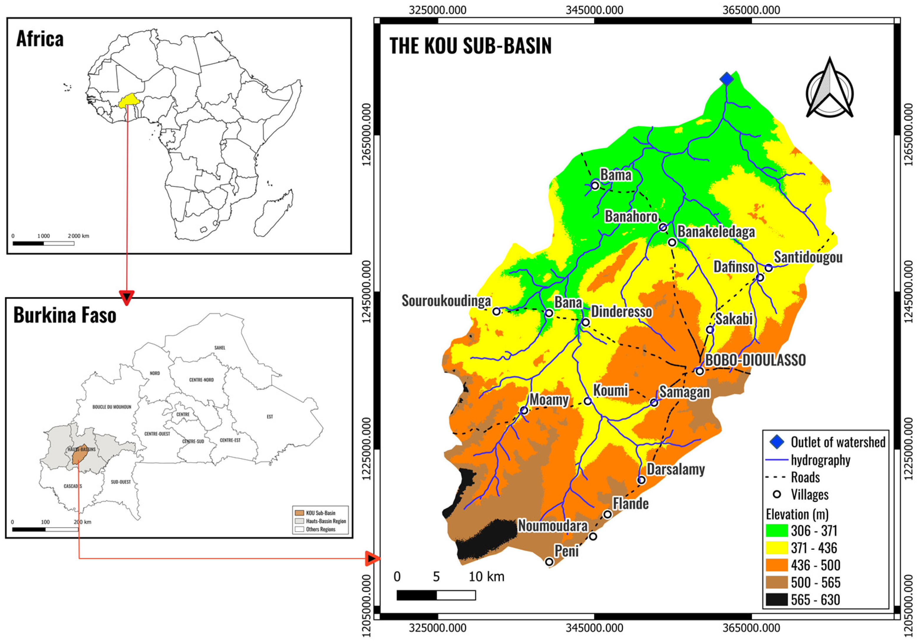
2.1. Location
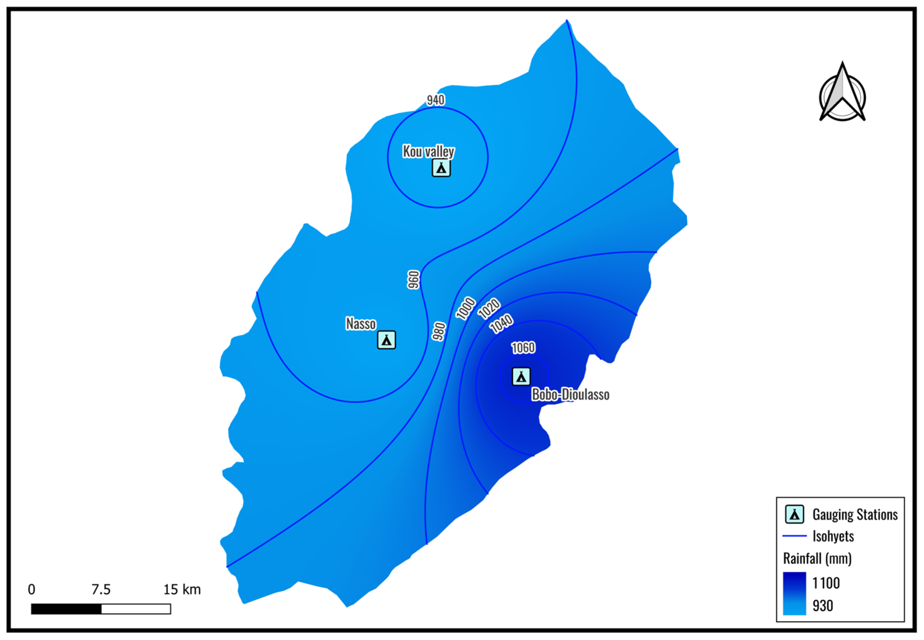
2.2. Climate
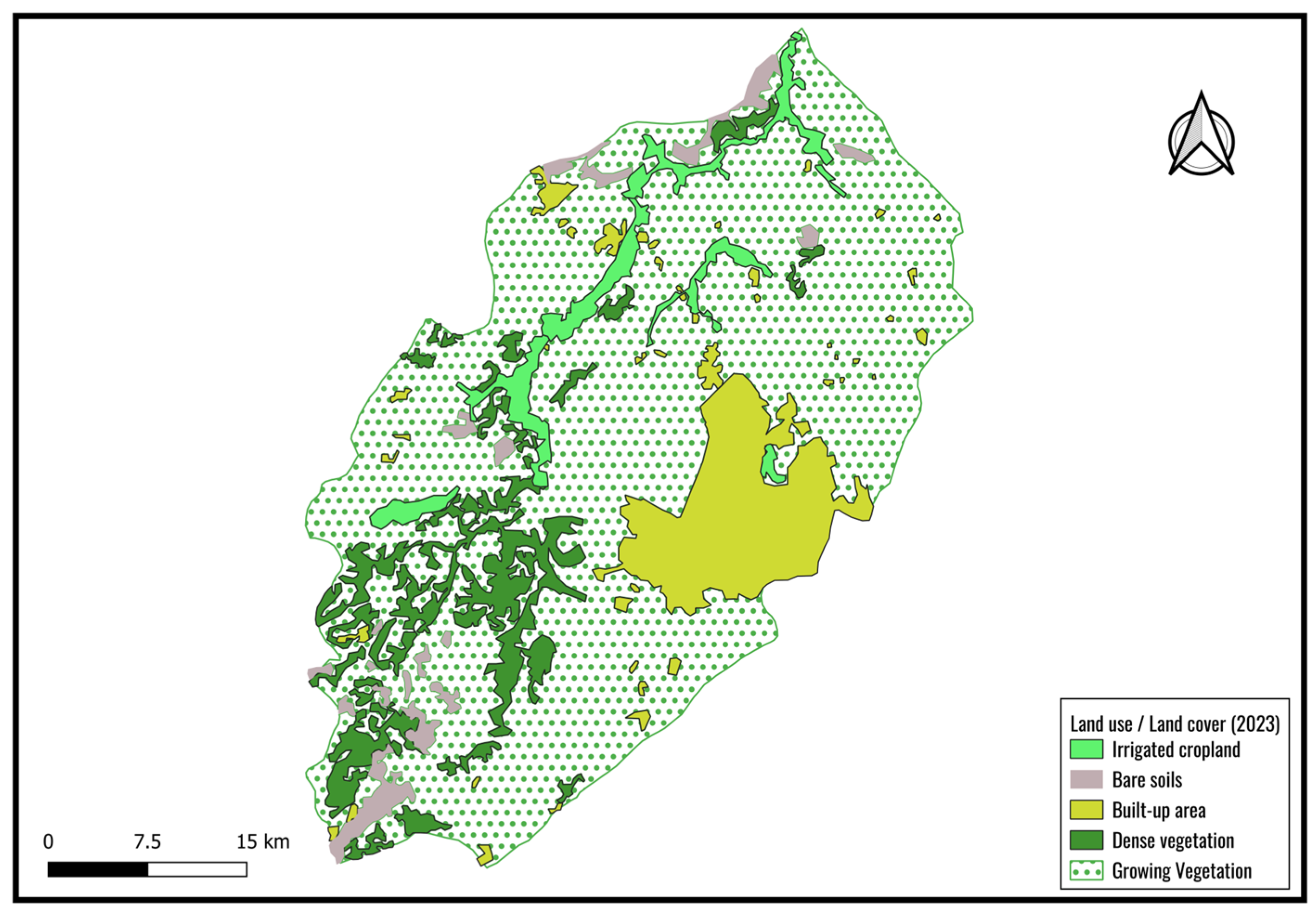
2.3. Relief, Land Use/Land Cover, and Soils
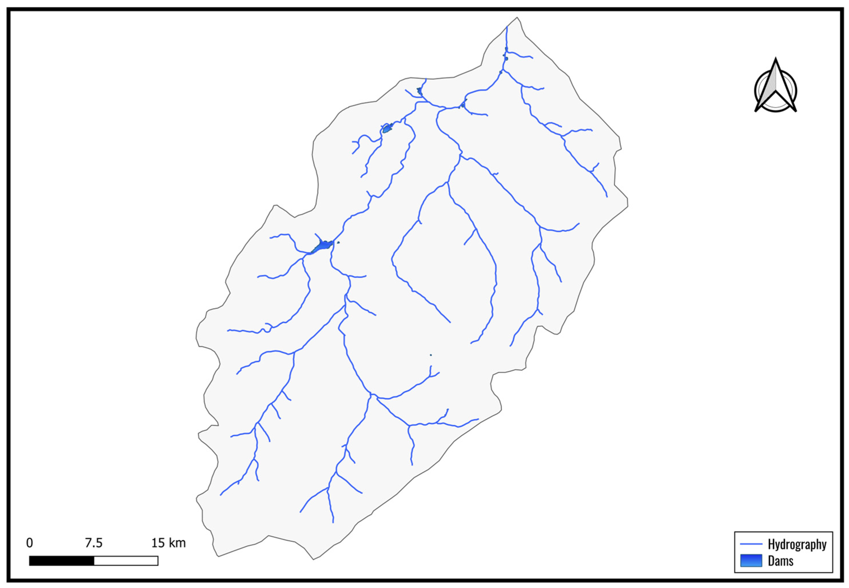
2.4. Hydrology
2.5. Geology
2.6. Hydrogeology
2.7. Population Growth, Dynamics, and Socio-Economic Activities
3. Synthesis of Vulnerability Studies
3.1. Literature Search Methodology
3.2. Summary of Earlier Studies Conducted in the Kou Sub-Basin
3.2.1. Groundwater Vulnerability-Related Studies
3.2.2. Groundwater Quality and Geochemical Assessments-Related Studies
3.2.3. Isotopic Analyses and Groundwater Residence Time-Related Studies
3.3. Current Knowledge on Groundwater Vulnerability in the Kou Sub-Basin
3.3.1. Groundwater Vulnerability
3.3.2. Groundwater Quality
3.3.3. Residence Time and Aquifer Stratification
3.3.4. Recharge Mechanisms and Uncertainty
3.3.5. Integrated Outlook
3.4. Methodological Limitations
4. Conclusions and Perspectives
Author Contributions
Funding
Data Availability Statement
Acknowledgments
Conflicts of Interest
References
- Taylor, R.G.; Scanlon, B.; Döll, P.; Rodell, M.; Van Beek, R.; Wada, Y.; Longuevergne, L.; Leblanc, M.; Famiglietti, J.S.; Edmunds, M.; et al. Ground water and climate change. Nat. Clim. Change 2013, 3, 322–329. [Google Scholar] [CrossRef]
- de Marsily, G.; Besbes, M. Groundwater [Les Eaux Souterraines]. 2017. Available online: https://lc.em-normandie.fr/Default/doc/CAIRN/0d720b92400ecf65d0e335c316cccd32/les-eaux-souterraines (accessed on 25 March 2025).
- Girard, F.; Kergoat, L.; Nikiema, H.; Wubda, M.; Yonaba, R.; Fowé, T.; Touré, A.A.; Mainassara, I.; De Fleury, M.; Grippa, M. Comparison of Methods to Derive the Height-Area Relationship of Shallow Lakes in West Africa Using Remote Sensing. Water Resour. Res. 2025, 61, e2024WR037411. [Google Scholar] [CrossRef]
- Kafando, M.B.; Koïta, M.; Le Coz, M.; Yonaba, O.R.; Fowe, T.; Zouré, C.O.; Faye, M.D.; Leye, B. Use of multidisciplinary approaches for groundwater recharge mechanism characterization in basement aquifers: Case of Sanon experimental catchment in Burkina Faso. Water 2021, 13, 3216. [Google Scholar] [CrossRef]
- Kafando, M.B.; Boko, B.A.; Yonaba, R.; Koïta, M.; Dobi, F.B.; Bambara, A.; Mounirou, L.A. Influence of past climatic conditions on groundwater levels in basement aquifers of the Sahel. Hydrogeol. J. 2025, 33, 531–551. [Google Scholar] [CrossRef]
- Mester, T.; Szabó, G.; Kiss, E.; Balla, D. Long-term spatiotemporal changes in nitrate contamination of municipal groundwater resources after sewerage network construction in the Hungarian Great Plain. Environ. Sci. Pollut. Res. 2024, 31, 61114–61137. [Google Scholar] [CrossRef] [PubMed]
- Zhai, Y.; Han, Y.; Xia, X.; Li, X.; Lu, H.; Teng, Y.; Wang, J. Anthropogenic Organic Pollutants in Groundwater Increase Releases of Fe and Mn from Aquifer Sediments: Impacts of Pollution Degree, Mineral Content, and pH. Water 2021, 13, 1920. [Google Scholar] [CrossRef]
- Lèye, B.; Zouré, C.O.; Yonaba, R.; Karambiri, H. Water Resources in the Sahel and Adaptation of Agriculture to Climate Change: Burkina Faso. In Climate Change and Water Resources in Africa; Diop, S., Scheren, P., Niang, A., Eds.; Springer International Publishing: Cham, Switzerland, 2021; pp. 309–331. ISBN 978-3-030-61224-5. [Google Scholar]
- Ali, M.; Mubarak, S. Approaches and Methods of Quantifying Natural Groundwater Recharge—A Review. AJEE 2017, 5, 1–27. [Google Scholar] [CrossRef]
- Harouna Moussa, A.K. Aquifer Recharge Assessment in Burkina Faso: Comparative Study of Relevant Recharge Assessment Methods in Arid and Semi-Arid Zones, Synthesis and Critical Analysis of Existing Aquifer Recharge Estimates. [Évaluation de la Recharge des Aquifères du Burkina Faso: Étude Comparative des Méthodes Pertinentes D’évaluation de la Recharge en Zones Aride et Semi-Aride, Synthèse et Analyse Critique des Estimations Existantes de la Recharge des Aquifères]. Master’s Thesis, Institut International d’Ingénierie de l’Eau et de l’Environnement, Ouagadougou, Burkina Faso, 2022. [Google Scholar]
- Foster, S.S. Impacts of urbanisation on groundwater. In Proceedings of the Duisberg Symposium; IAHS Publications: Oxfordshire, UK, 1988; Volume 198, pp. 2–23. [Google Scholar]
- Scanlon, B.R.; Healy, R.W.; Cook, P.G. Choosing appropriate techniques for quantifying groundwater recharge. Hydrogeol. J. 2002, 10, 18–39. [Google Scholar] [CrossRef]
- Collignon, B. Impact of human activities on groundwater resources in Sahelian and Sudanian Africa [Impact des activités humaines sur les ressources en eau souterraine en Afrique sahélienne et soudanienne]. In Enregistreurs et Indicateurs de l’Évolution de l’Environnement en Zone Tropicale; OpenEdition Books: Marseille, France, 1994; pp. 235–249. [Google Scholar]
- Mei, L. Water resources in Burkina Faso: Management and challenges [La ressource en eau au Burkina Faso gestion et enjeux]. Trav. Lab. Géogr. Phys. Appl. 2003, 22, 37–55. [Google Scholar] [CrossRef]
- Rouabhia, A.; Baali, F.; Kherici, N.; Djabri, L. Vulnerability and pollution risk of groundwater in the Miocene sands of the El Ma El Abiod plain (Algeria) [Vulnérabilité et risque de pollution des eaux souterraines de la nappe des sables miocènes de la plaine d’El Ma El Abiod (Algérie)]. Rev. Sécher. 2004, 15, 347–352. [Google Scholar]
- Lorenzini, G. Assessment of groundwater resources in the Kou basin [Etat des lieux des ressources en eaux souterraines du Bassin du Kou]. Burkina Faso, 2007; p. 125. [Google Scholar]
- Oke, S.A. An overview of aquifer vulnerability. In Glaciology for Glacial Geologists; Nova Science Publishers: Hauppauge, NY, USA, 2017; ISBN 978-1-5361-1069-2. [Google Scholar]
- Water Help Desk Improving Water Knowledge and Management in Burkina Faso [Amélioration de la Connaissance et de la Gestion des eaux au Burkina Faso]; Banque Mondiale, Water Partership Program, Wsp: Ouagadougou, Burkina Faso, 2017; p. 90.
- Veyret, Y.; Reghezza, M. Hazards and risks in geographic analysis [Aléas et risques dans l’analyse géographique]. In Annales des Mines; 2005; Volume 40, pp. 61–69. Available online: https://www.annales.org/re/2005/resumes/octobre/05-re-resum-FR-AN-AL-ES-octobre-2005.html (accessed on 25 March 2025).
- Beck, E. Multi-Risk Approach in an Urban Environment. The Case of Seismic and Technological Risks in the Mulhouse Conurbation (Haut-Rhin) [Approche Multi-Risques en Milieu Urbain. Le Cas des Risques Sismique et Technologiques dans l’Agglomération de Mulhouse (Haut-Rhin)]. Ph.D. Thesis, Université Louis Pasteur Strasbourg I, Strasbourg, France, 2006. [Google Scholar]
- Dubois-Maury, J. Natural hazards in France: Between spatial regulation and compensation solidarity [Les risques naturels en France, entre réglementation spatiale et solidarité de l’indemnisation]. Geo 2002, 111, 637–651. [Google Scholar] [CrossRef]
- Vanpeene Bruhier, S. Environmental Risk Assessment for Sustainable Land Management [Evaluation des Risques Environnementaux Pour une Gestion Durable des Espaces]. Cemagref Editions. 2003. Available online: https://hal.inrae.fr/hal-02581722v1 (accessed on 25 March 2025).
- Harkat, N.; Chaouche, S. Urban Vulnerability of Algerian Cities to the Risk of Flooding [Vulnérabilité Urbaine des Villes Algériennes Face au Risque D’inondations]. Master’s Thesis, Faculté d’Architecture et d’Urbanisme, Université Constantine 3 Salah Boubnider, Constantine, Algeria, 2021. [Google Scholar]
- Murat, V. Comparative Study of Methods for Assessing the Intrinsic Vulnerability of Aquifers to Pollution: Application to Granular Aquifers in the Laurentian Piedmont [Étude Comparative des Méthodes D’évaluation de la Vulnérabilité Intrinsèque des Aquifères à la Pollution: Application aux Aquifères Granulaires du Piémont Laurentien]; Institut National de la Recherche Scientifique (Canada): Québec, QC, Canada, 2000; ISBN 979-8-3796-4620-2. [Google Scholar]
- Murat, V.; Paradis, D.; Savard, M.; Nastev, M.; Bourque, E.; Hamel, A.; Lefebvre, R.; Martel, R. Groundwater Vulnerability of Fractured Aquifers in Southwestern Quebec: Assessment Using DRASTIC and GOD Methods. [Vulnérabilité à la Nappe des Aquifères Fracturés du Sud-Ouest du Québec: Évaluation par les Méthodes DRASTIC et GOD]; Ressources Naturelles Canada, Commission géologique du Canada: Calgary, AB, Canada, 2003; ISBN 0-662-88653-4. [Google Scholar]
- Latifi, S.; Chaab, S. Assessment and mapping of vulnerability to groundwater pollution, using DRASTIC and GOD methods, in the Guelma alluvial plain, North-East Algeria [Evaluation et cartographie de la vulnérabilité à la pollution des eaux souterraines, selon les méthodes DRASTIC et GOD, dans la plaine alluviale de Guelma, Nord-Est Algérien]. Synthèse Rev. Des. Sci. Technol. 2017, 34, 48–62. [Google Scholar]
- Faye, M.D.; Loyara, V.Y.B.; Biaou, A.C.; Yonaba, R.; Koita, M.; Yacouba, H. Modelling groundwater pollutant transfer mineral micropollutants in a multi-layered aquifer in Burkina Faso (West African Sahel). Heliyon 2024, 10, e23557. [Google Scholar] [CrossRef] [PubMed]
- Kutangila, S.M.; Kafando, M.B.; Keita, A.; Mounirou, L.A.; Yonaba, R.; Ouedraogo, M.; Koita, M. Subsurface Hydrodynamics of the Southeastern Taoudéni Basin (West Africa) through Hydrogeochemistry and Isotopy. Water 2024, 16, 1922. [Google Scholar] [CrossRef]
- Wellens, J.; Traore, F.; Niamian, M.-J.; Diallo, M.; Compaore, N.; Dakoure, D.; Derouane, J.; Tychon, B. Drawing up a Water Balance for the Kou Watershed and Critical Analysis of the Main Components [Elaboration du Bilan D’eau du Bassin Versant du Kou et Analyse Critique des Principaux Composants]. 2008. Available online: https://orbi.uliege.be/handle/2268/172888 (accessed on 25 March 2025).
- INSD. 5ème Recensement Général de la Population et de l’Habitation du Burkina Faso; Comité National du Recensement Institut National de la Statistique et de la Démographie: Ouagadougou, Burkina Faso, 2022; p. 136. [Google Scholar]
- Guelbeogo, S.; Ouedraogo, L. Flood risk mapping in the Kou watershed, Burkina Faso [Cartographie des risques d’inondation dans le bassin versant du Kou au Burkina Faso]. Afr. Sci. 2022, 21, 60–75. [Google Scholar]
- Kam, M.A. Characterization of Agricultural Pollution Sources in the Kou Basin and Initial Mapping of Aquifer Vulnerability [Caractérisation des Sources de Pollution Agricoles dans le Bassin du Kou et Première Ébauche de Cartographie de la Vulnérabilité des Aquifères]; Université de Ouagadougou (UJKZ): Ouagadougou, Burkina Faso, 2007; p. 73. [Google Scholar]
- Sontie, F. Study of Water Resource Conflicts in the Diarradougou and Bama Region (Kou Valley) [Etude des Conflits Autour de la Ressource Eau dans la Région de Diarradougou et Bama (Vallée du Kou)]; 2iE: Ouagadougou, Burkina Faso, 2006; p. 66. [Google Scholar]
- 2AEI Implementation of a Water Allocation System on the Bama Plain [Mise en Place D’un Système D’allocation de L’eau au Niveau de la Plaine de Bama]; Minsitère de l’Environnement, de l’Eau et de l’Assainissement (Agence de l’Eau du Mouhoun) et Groupement D’interet Public: Ouagadougou, Burkina Faso, 2023; p. 87.
- CIEDEL Inventory and Diagnosis of Water Resources in the Kou Sub-Basin [Etat des Lieux et Diagnostic des Ressource en Eau du Sous-Bassin du Kou]; Conseil Régional des Hauts Bassins, La Réfion Auvergne-Rhône-Alpes, Eau Vive Internationale: Ouagadougou, Burkina Faso, 2020; p. 108.
- Traore, F. Methods for Estimating Real Evapotranspiration at the Scale of the Kou Watershed in Burkina Faso [Méthodes D’estimation de L’évapotranspiration Réelle à L’échelle du Bassin Versant du Kou au Burkina Faso]; Université de Liège: Liège, Burkina Faso, 2007; p. 133. [Google Scholar]
- Traore, F. Optimizing the Use of Water Resources in the Kou Basin for Agricultural Purposes [Optimisation de L’utilisation des Ressources en Eau du Bassin du Kou pour des Usages Agricoles]. Ph.D. Thesis, Université de Liège, Liège, Burkina Faso, 2012. [Google Scholar]
- Sauret, E. Study of the Hydrogeological Potential of an Alluvial Plain in Relation to Groundwater and Surface Water in a Context of Irrigated Agriculture (Burkina Faso) [Etude des Potentialités Hydrogéologiques D’une Plaine Alluviale en Relation Avec les eaux Souterraines et de Surface dans un Contexte D’agriculture Irriguée (Burkina Faso)]. Ph.D. Thesis, ULiège—Université de Liège, Liège, Burkina Faso, 2013. [Google Scholar]
- Yofe/Tirogo, J. Study of the Hydrodynamic Functioning of the Sedimentary Aquifer of the Kou Basin in Southwest Burkina Faso [Etude du Fonctionnement Hydrodynamique de L’aquifère Sédimentaire du Bassin du Kou au Sud-Ouest du Burkina Faso]. Ph.D. Thesis, Université Pierre et Marie Curie-Paris VI, Institut International d’Ingénierie de l’Eau et de l’Environnement, Ouagadougou, Burkina Faso, 2016. [Google Scholar]
- Derouane, J. Hydrogeological Modeling of the Sedimentary Basin [Modélisation Hydrogéologique du Bassin Sédimentaire]; Programme de Valorisation des Ressources en Eau de l’Ouest (VREO): Ouagadougou, Burkina Faso, 2008; p. 101. [Google Scholar]
- Ouédraogo, C. Geological Synthesis of the Western Region of Burkina Faso [Synthèse Géologique de la Région Ouest du Burkina Faso]; Programme de Valorisation des Ressources en Eau de l’Ouest (VREO): Ouagadougou, Burkina Faso, 2006; p. 46. [Google Scholar]
- SOGREAH Study of Groundwater Resources in the Sedimentary Zone of the Bobo Dioulasso Region [Etude des Ressources en eau Souterraine de la Zone Sédimentaire de la Région de Bobo Dioulasso]; Ministère de l’Eau: Ouagadougou, Burkina Faso, 1994; p. 291.
- Dakoure, D. Hydrogeological and Geochemical Study of the Southeastern Edge of the Taoudéni Sedimentary Basin (Burkina Faso—Mali)—Modeling Test [Etude Hydrogéologique et Géochimique de la Bordure Sud-Est du Bassin Sédimentaire de Taoudéni (Burkina Faso—Mali)—Essai de modélisation]. Ph.D. Theses, Université Pierre et Marie Curie, Paris, France, 2003. [Google Scholar]
- Dahl, R. Geological, structural and mineral synthesis map of BURKINA FASO, scale 1:1,000,000 [Carte de synthèse géologique, structurale et des substances minérales du BURKINA FASO à l’échelle 1/1 000 000] 2018. Available online: https://scholar.google.com/scholar?hl=fr&as_sdt=0%2C5&q=Carte+de+synth%C3%A8se+g%C3%A9ologique%2C+struc-tura-le+et+des+substances+min%C3%A9rales+du+BURKINA+FASO+%C3%A0+l%E2%80%99%C3%A9chelle+1%2F1+000+000&btnG= (accessed on 25 March 2025).
- Talbaoui, M. Study of the Protection Perimeters of Nasso Springs and ONEA Boreholes [Etude des Périmètres de Protection des Sources de Nasso et des Forages de l’ONEA]; Programme de Valorisation des Ressources en Eau de l’Ouest (VREO): Ouagadougou, Burkina Faso, 2009; p. 84. [Google Scholar]
- Kafando, M.B.; Koïta, M.; Zouré, C.O.; Yonaba, R.; Niang, D. Quantification of Soil Deep Drainage and Aquifer Recharge Dynamics according to Land Use and Land Cover in the Basement Zone of Burkina Faso in West Africa. Sustainability 2022, 14, 14687. [Google Scholar] [CrossRef]
- Kouanda, B. Integrated Modeling of the Upper Mouhoun-Sourou Complex in the Context of Climate Change [Modélisation Intégrée du Complexe Mouhoun Supérieur-Sourou dans le Contexte des Changements Climatiques]. Ph.D. Thesis, 2iE, Ouagadougou, Burkina Faso, 2019. [Google Scholar]
- Dao, D.M. Exploitation Rates and Sustainability of Water Resources in the Kou and Karfiguela Alluvial Aquifers [Taux D’exploitation et Durabilité de la Ressource en Eau des Aquifères Alluviaux du Kou et de Karfiguela]; 2iE: Ouagadougou, Burkina Faso, 2015; p. 115. [Google Scholar]
- Héma, B.; Sauret, E. Identification and Characterization of the Geomorphological Units of the Alluvial Plain of the Kou Basin from Kokoroué to Bama/Badara (Burkina Faso) [Identification et Caractérisation des Unités Géomorphologiques de la Plaine Alluviale du Bassin du Kou de Kokoroué à Bama/Badara (Burkina Faso)]; Projet Eaux Souterraines: Ouagadougou, Burkina Faso, 2010. [Google Scholar]
- SHER/ARTELIA Geological and Hydrogeological Modelling of the West Burkina Faso Sedimentary Basin [Modélisation Géologique et Hydrogéologique du Sédimentaire de l’Ouest du Burkina Faso]; Minsitère de l’Environnement, de l’Eau et de l’Assainissement (Programme d’Approvisionnement en Eau et d’Assainissement): Ouagadougou, Burkina Faso, 2023; p. 152.
- CACI/GERTEC Piezometric Levelling of Springs and Estimation of the Quantities of Water Abstracted from the West Burkina Sedimentary Basin for the Water Supply and Sanitation Program (PAEA). [Réalisation du Nivellement Piézométrique des Sources et L’estimation des Quantités D’eau Prélevées dans le Bassin Sédimentaire de l’Ouest du Burkina au Profit du Programme d’Approvisionnement en Eau et d’Assainissement (PAEA)]; Minsitère de l’Environnement, de l’Eau et de l’Assainissement (Programme d’Approvisionnement en Eau et d’Assainissement): Ouagadougou, Burkina Faso, 2023; p. 188.
- Yanogo, N.F. Study of the Vulnerability to Pollution of Aquifers in the Kou Watershed in Southwest BURKINA Faso [Etude de la Vulnérabilité à la Pollution des Aquifères du Bassin Versant du Kou, dans le sud Ouest du Burkina Faso]; ENI/ABT: Ouagadougou, Burkina Faso, 2008; p. 68. [Google Scholar]
- Bieupoudé, G.P. Mapping Groundwater Intrinsic Vulnerability Using a New Physically Based Modeling in Kou Basin Bobo-Dioulasso/Burkina Faso; 2iE: Ouagadougou, Burkina Faso, 2008; p. 63. [Google Scholar]
- Huneau, F.; Dakoure, D.; Celle-Jeanton, H.; Vitvar, T.; Ito, M.; Traore, S.; Compaore, N.F.; Jirakova, H.; Le Coustumer, P. Flow pattern and residence time of groundwater within the south-eastern Taoudeni sedimentary basin (Burkina Faso, Mali). J. Hydrol. 2011, 409, 423–439. [Google Scholar] [CrossRef]
- Taupin, J.D. Integrated and Sustainable Management of Aquifer Systems and Shared Basins in the Sahel Region [Gestion Intégrée et Durable des Systèmes Aquifères et des Bassins Partagés de la Région du Sahel]; Agence internationale de l’énergie atomique (AIEA): Principauté de Monaco, France, 2017; p. 136. [Google Scholar]
- Service, E. Hydrochemical Characteristics of Groundwater in Bobo—Dioulasso (Burkina-Faso) [Caractéristiques Hydro-chimiques des Eaux Souterraines de la Ville de Bobo—Dioulasso (Burkina-Faso)]; Institut Supérieur d’Application des Géosciences: Ouagadougou, Burkina Faso, 2018; p. 69. [Google Scholar]
- Wang, X.; Sun, J. The Temporal Evolution Characteristics of Extreme Rainfall in Shenzhen City, China. Sustainability 2025, 17, 3512. [Google Scholar] [CrossRef]


| Reference | Year | Method | Estimate (mm·year−1) |
|---|---|---|---|
| SOGREAH [42] | 1994 | Water balance method (Thornthwaite) | 248 |
| Dakouré [43] | 2003 | Water balance (Thornthwaite) | 75–120 |
| Volume variation from piezometric fluctuations | <16 | ||
| Hydrological reservoir modeling | 127 | ||
| Hydrogeological modeling (Processing-MODFLOW) | 0–47 | ||
| Derouane [40] | 2008 | Hydrogeological modeling (MODFLOW) | 20–160 |
| Water balance method (Thornthwaite) | 26–42 | ||
| Sauret [38] | 2013 | Water balance method (Thornthwaite)—1961–2010 | 354–200 |
| 2013 | Water balance method (FAO-56 Penman–Monteith) (1961–2010) | 288–69 | |
| Dao [48] | 2015 | Water balance method (Thornthwaite) | 26.13 |
| Yofe/Tirogo [39] | 2016 | Water balance method (Thornthwaite) | 60–150 |
| Hydrogeological modeling (Visual MODFLOW) | 95–115 | ||
| Kouanda [47] | 2019 | Hydrogeological modeling (SWAT) | 124 |
| Reference | Year | Methodology | Type of Vulnerability Assessed | Key Results/Vulnerability Index | Spatial Highlights |
|---|---|---|---|---|---|
| SOGREAH [42] | 1994 | Stratigraphic analysis of superficial layers | Intrinsic | Vulnerability map produced based on superficial thickness | High vulnerability in the upstream area of the Nasso springs (alluvial plain) |
| Kam [32] | 2007 | DRASTIC method | Intrinsic + Specific (pesticides) | Intrinsic: Index range 50–170 Pesticides: 0–230+ | High vulnerability near rivers and urban fringe of Bobo-Dioulasso |
| Yanogo [52] | 2008 | DRASTIC, Improved DRASTIC, and GOD methods | Intrinsic + Specific + Risk | DRASTIC: 0–116 Improved DRASTIC: 110–208 GOD: 0–0.49 | Elevated risk in urban-industrial zones and downstream agricultural areas |
| Bieupoudé & Gardin [53] | 2008 | APSU (Belgian method) | Risk and Transport Dynamics | 4 maps: transfer time, dilution duration, global vulnerability, and vulnerability–land use overlap | Vulnerability highest in lowlands (alluvial plain) and northern Bobo-Dioulasso; dilution time > 10 years in Nasso |
| Talbaoui [45] | 2009 | MODFLOW/MT3D modeling + Fluorescein tracer injection | Risk-based contamination modeling | Pollutant travel time: 18–20 years to Nasso sources | Pollution from industrial zones and roads can eventually reach water supply springs |
| Reference | Year | Geographical Focus | Major Findings | Indicators of Contamination |
|---|---|---|---|---|
| Dakouré [43] | 2003 | Taoudéni Basin (Burkina Faso) | Ca-HCO3 facies dominant; generally potable water. Some exceedances in K+, Fe, and NO3− in isolated samples across formations. | Localized pollution from agriculture (nitrates, iron) |
| Huneau et al. [54] | 2011 | Taoudéni Basin (multi-country) | Hydrochemistry varies by lithology. Higher bicarbonate, Ca, Mg in carbonate units. Sulfates high in Sac1/Sac2. Nitrates mostly low. | Some samples exceed 160–300 mg/L NO3− in Gfg and CT |
| Taupin [55] | 2017 | Western Burkina Faso | EC 1 highly variable (58–1856 µS/cm), reflecting both geology and nitrate contamination. HCO3–Mg facies predominant, some shifts to more alkaline types. | Nitrates and K+ indicate anthropogenic sources |
| Service [56] | 2018 | Bobo-Dioulasso area | 37% Ca-Mg-HCO3, 39% Ca-Mg-Cl-SO4, others minor. 65.71% potable, but 41.23% show anomalies (high turbidity, NO3− up to 68.9 mg/L). | Industrial and agricultural impacts |
| Kouanda [47] | 2019 | Upper Mouhoun Basin | Dominant Ca-Mg-HCO3 facies; evolution toward Cl−-rich waters (Ca-Mg-Cl-SO4) in some areas due to ion exchange. | Anthropogenic influence inferred |
| Kutangila et al. [28] | 2024 | Western Sedimentary Basin (Burkina Faso) | Two dominant facies: Ca–Mg–HCO3 and Na–K–HCO3. EC averages ~283 µS/cm. Isolated high EC and nitrate levels in some zones. | Mix of natural hydrolysis and localized pollution |
| Reference | Year | Methods Used | Major Findings | Implications |
|---|---|---|---|---|
| Dakoure [43] | 2003 | δ18O, δ2H, 3H, 14C | Sedimentary aquifers show depleted isotopic signatures near GMWL; meteoric origin with minimal evaporation | Indicates deep recharge; residence time > 50 years |
| Basement/superficial aquifers enriched in heavy isotopes; some evidence of evaporation/mixing | Suggests recent recharge or pollution near urban areas | |||
| Huneau et al. [54] | 2011 | δ18O, δ2H, 3H, 14C, 13C | Low/absent 3H in deep layers, detectable 3H in shallow systems | Confirms stratified residence times across aquifer layers; residence time 25,000–42,000 years |
| Kouanda [47] | 2019 | δ18O, δ2H, 3H | Strong interaction between surface water and groundwater. Tritium found in shallow zones only | Stratified recharge: recent in shallow wells, older in deep aquifers |
| Kutangila et al. [28] | 2024 | δ18O, δ2H, 3H | Defined three compartments: (1) recent recharge zone, (2) intermediate mixing zone, (3) deep, old water | Highlights compartmentalization and varying vulnerability levels |
| Theme | Major Findings | Implications |
|---|---|---|
| Vulnerability | Moderate to high in shallow, agricultural, and peri-urban zones. High-risk zones near Kou River, Nasso springs, and Bobo-Dioulasso. | Targeted protection needed; vulnerability mapping must account for land use and geological layering. |
| Water Quality | Dominant Ca–Mg–HCO3 facies; local nitrate and iron pollution; EC heterogeneity linked to both geology and human activities. | Pollution risks from agriculture and urban runoff; need for localized water quality monitoring. |
| Residence Time | Deep aquifers: >50 years (fossil water), no tritium. Shallow aquifers: recent recharge detected. Stratification confirmed via isotopes. | Differential management by aquifer depth; deep aquifers less vulnerable but slower to recharge. |
| Recharge Mechanisms | Estimated at 0–354 mm·year−1 depending on method. Localized recharge in fractured zones and alluvial corridors. Uncertainty remains high. | Recharge estimates must be refined using multi-method approaches; avoid over-abstraction assumptions. |
Disclaimer/Publisher’s Note: The statements, opinions and data contained in all publications are solely those of the individual author(s) and contributor(s) and not of MDPI and/or the editor(s). MDPI and/or the editor(s) disclaim responsibility for any injury to people or property resulting from any ideas, methods, instructions or products referred to in the content. |
© 2025 by the authors. Licensee MDPI, Basel, Switzerland. This article is an open access article distributed under the terms and conditions of the Creative Commons Attribution (CC BY) license (https://creativecommons.org/licenses/by/4.0/).
Share and Cite
Coulidiati, T.F.A.; Biaou, A.C.; Faye, M.D.; Yonaba, R.; Sauret, E.S.G.; Compaoré, N.F.; Koïta, M. Groundwater Vulnerability in the Kou Sub-Basin, Burkina Faso: A Critical Review of Hydrogeological Knowledge. Water 2025, 17, 1317. https://doi.org/10.3390/w17091317
Coulidiati TFA, Biaou AC, Faye MD, Yonaba R, Sauret ESG, Compaoré NF, Koïta M. Groundwater Vulnerability in the Kou Sub-Basin, Burkina Faso: A Critical Review of Hydrogeological Knowledge. Water. 2025; 17(9):1317. https://doi.org/10.3390/w17091317
Chicago/Turabian StyleCoulidiati, Tani Fatimata Andréa, Angelbert Chabi Biaou, Moussa Diagne Faye, Roland Yonaba, Elie Serge Gaëtan Sauret, Nestor Fiacre Compaoré, and Mahamadou Koïta. 2025. "Groundwater Vulnerability in the Kou Sub-Basin, Burkina Faso: A Critical Review of Hydrogeological Knowledge" Water 17, no. 9: 1317. https://doi.org/10.3390/w17091317
APA StyleCoulidiati, T. F. A., Biaou, A. C., Faye, M. D., Yonaba, R., Sauret, E. S. G., Compaoré, N. F., & Koïta, M. (2025). Groundwater Vulnerability in the Kou Sub-Basin, Burkina Faso: A Critical Review of Hydrogeological Knowledge. Water, 17(9), 1317. https://doi.org/10.3390/w17091317