
Alteration of Catchments and Rivers, and the Effect on Floods: An Overview of Processes and Restoration Actions


 , and
, and
Abstract
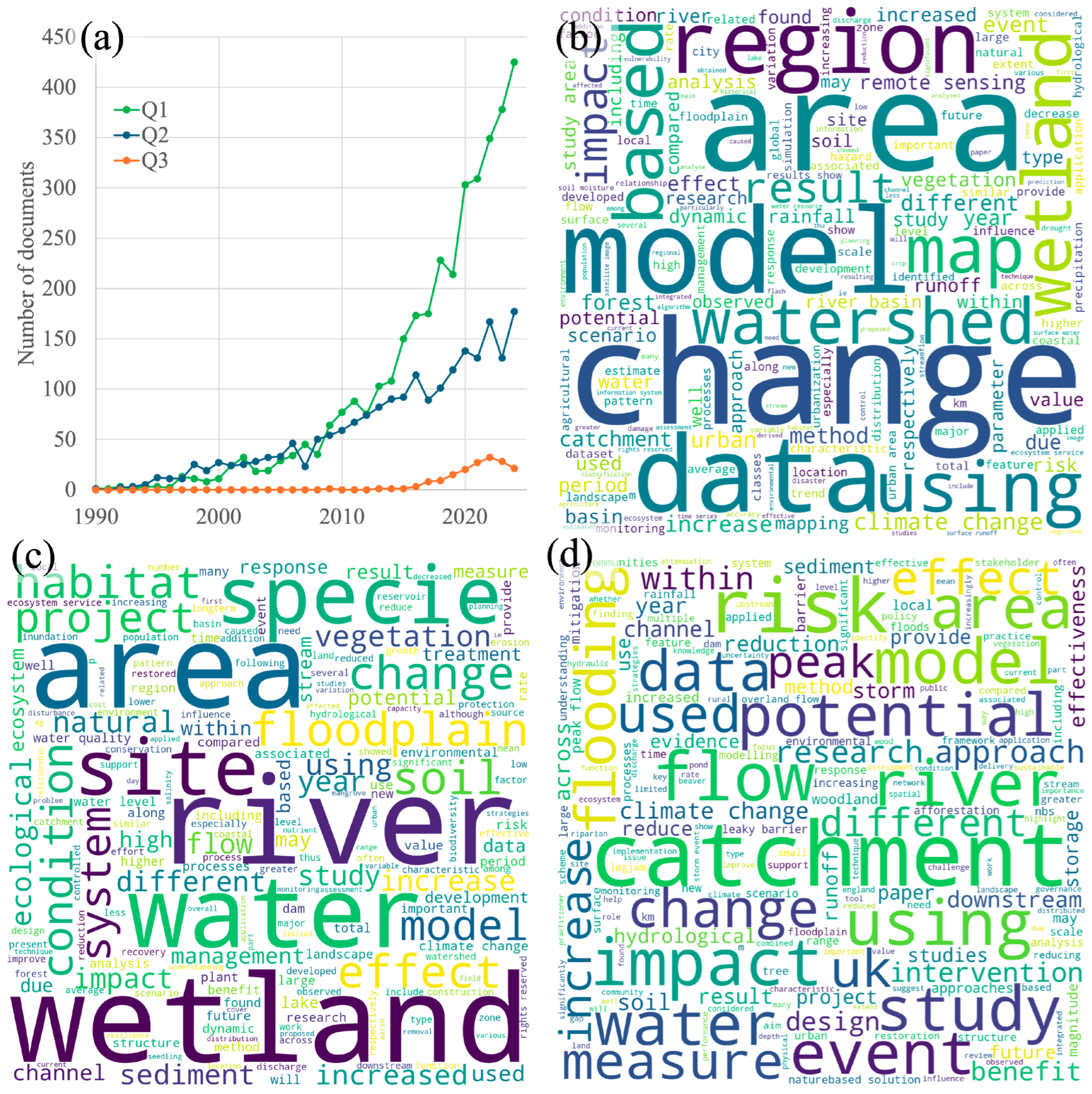
1. Introduction
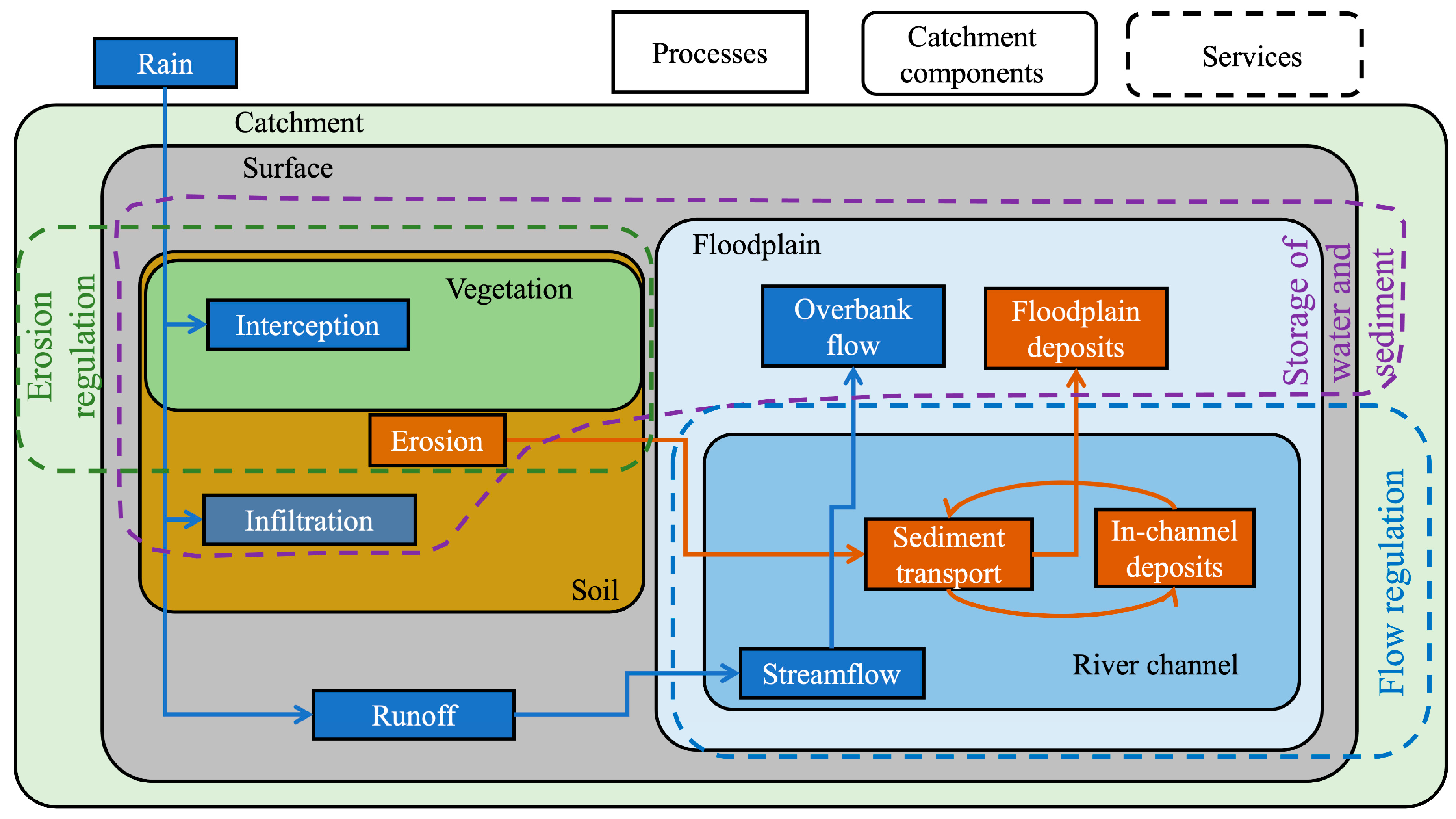
2. Watershed Alteration and Its Effect on Flooding
2.1. Land Use and Land Cover
2.2. Sediment Dynamics
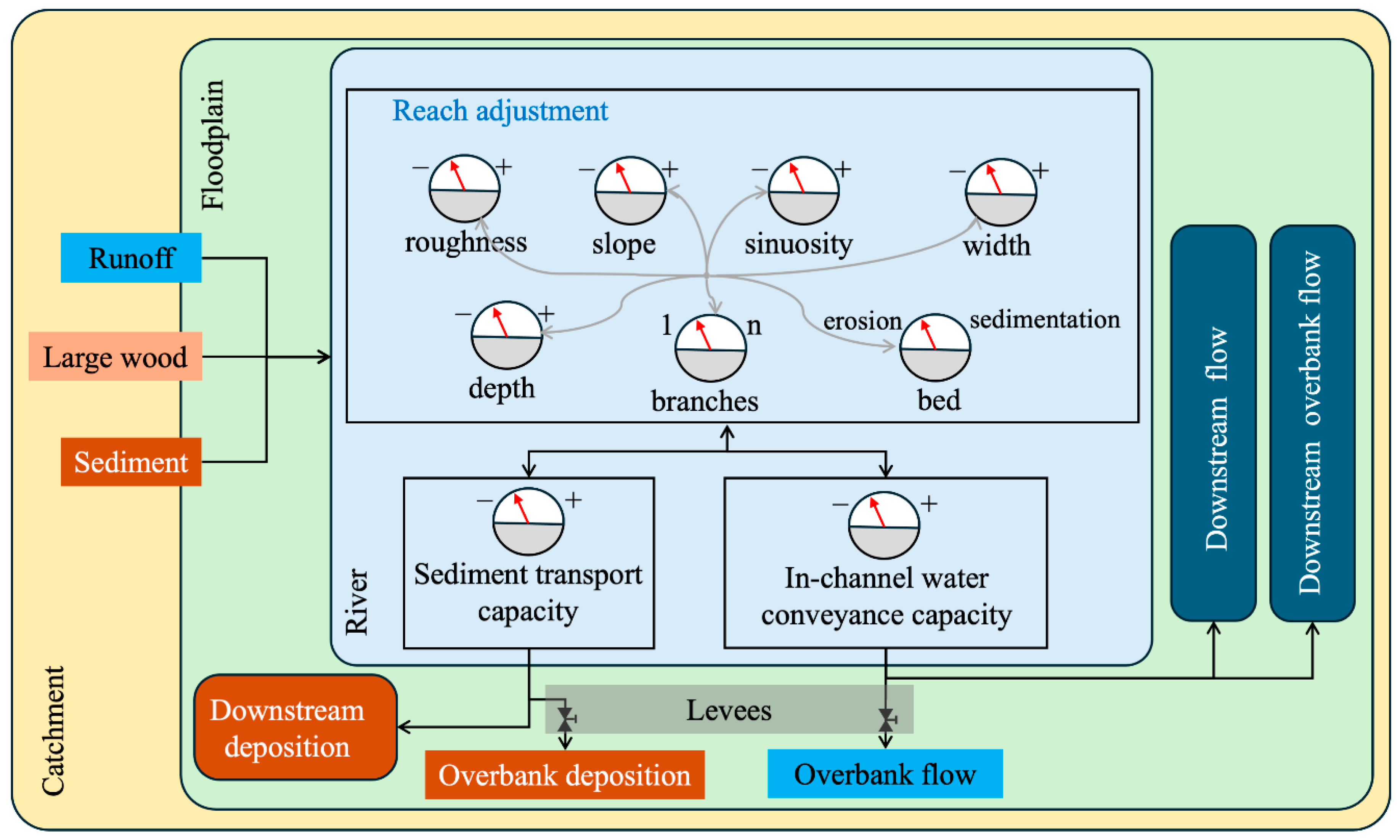
2.3. River Morphology

| Source | Method | Findings |
|---|---|---|
| James [68] | Analysis of historical and field data of the Bear and American catchments in the Sacramento Valley, California. | Hydraulic gold mining during the periods 1853–1884 and 1893–1954 in the Bear and American catchments produced aggradation and the stage–discharge relations. |
| Stover and Montgomery [62] | Analyzed field data of the Skokomish River, Washington. | Flooding at the end of the 20th century along the mainstem of the river was related to stage–discharge relation variations caused by aggradation; the upstream catchment was impacted by timber extraction and road construction. |
| Liébault and Piégay [69] | Utilized historical data (maps and air photos) to characterize the channel width of rivers in southeastern France. | The narrowing of channels accelerated in 1950–1970; the authors considered that this was driven by forest development on the river margins and the abandonment of intensive floodplain land use. |
| Lane et al. [70] | Utilized field data of the Wharfe River (UK) and a 1D–2D hydraulic model. | During the period from Dec-2001 to Mar-2004, the upper reach developed aggradation; the effect was a reduction of 6.1% in the bankfull discharge. |
| Dingle et al. [71] | Utilized a 2D hydrodynamic model of the Karnali River, Nepal, to simulate the effect of variable bed elevation. | Channel aggradation or incision in small magnitudes could significantly modify the extent of inundation across the low-relief landscape. |
2.4. Connectivity Channel–Floodplain
3. Restoration Techniques for Flood Mitigation
3.1. Perspectives of Flood Mitigation
3.2. Restoration and Enhancement of Flow Retention
3.3. Sediment Management
4. Assessment of Restoration Effectiveness
4.1. Hydro-Morphological Indexes
4.2. Evaluation of Restoration and NFM Actions
5. Discussion
6. Conclusions
Author Contributions
Funding
Data Availability Statement
Conflicts of Interest
Abbreviations
| LULC | Land Use and Land Cover |
| NBSs | Nature-based Solutions |
| NFM | Natural Flood Management |
| RDS | Rock Detention Structure |
References
- Tanoue, M.; Hirabayashi, Y.; Ikechi, H. Global-scale river flood vulnerability in the last 50 years. Sci. Rep. 2016, 6, 36021. [Google Scholar] [CrossRef]
- Tanoue, M.; Taguchi, R.; Nakata, S.; Watabe, S.; Fujimoru, S.; Hiranayashi, Y. Estimation of direct and indirect economic losses caused by a flood with long-lasting inundation: Application to the 2011 Thailand flood. Water Resour. Res. 2020, 56, e2019WR026092. [Google Scholar] [CrossRef]
- Preisser, M.; Passalacqua, P.; Bixler, P.R.; Hofmann, J. Intersection near-real time fluvial and pluvial inundation estimates with sociodemographic vulnerability to quantify a household flood impact index. Hydrol. Earth Syst. Sci. 2022, 26, 3941–3964. [Google Scholar] [CrossRef]
- Bates, P.; Quinn, N.; Sampson, C.; Smith, A.; Wing, O.; Sosa, J.E.A. Combined modeling of US fluvial, pluvial and coastal flood hazard under current and future climates. Water Resour. Res. 2021, 57, e2020WR028673. [Google Scholar] [CrossRef]
- Ward, P.J.; Jogman, B.; Weiland, F.S.; Bouwman, A.; van Beek, R.; Bierkens, M.F.P.; Ligtvoet, W.; Winsemius, H. Assessing flood risk at the global scale: Model setup, results and sensitivity. Environ. Res. Lett. 2013, 8, 044019. [Google Scholar] [CrossRef]
- Knox, R.; Wohl, E.; Morrison, R. Levees don’t protect, they disconnect: A critical review of how artificial levees impact floodplain functions. Sci. Total Environ. 2022, 837, 155773. [Google Scholar] [CrossRef] [PubMed]
- Anderson, D. Geomorphic responses to interim hydrology following phase I of the Kissimmee River restoration project, Florida. Restor. Ecol. 2014, 22, 367–375. [Google Scholar] [CrossRef]
- Tobin, G. The levee love affair: A stormy relationship? J. Am. Water Resour. Assoc. 1995, 31, 359–367. [Google Scholar] [CrossRef]
- White, G.; Kates, R.; Burton, I. Knowing better and losing even more: The use of knowledge in hazards management. Environ. Hazards 2001, 3, 81–92. [Google Scholar]
- Chen, X.; Wang, D.; Tian, F.; Sivapalan, M. From channelization to restoration: Sociohydrologic modeling with changing community preferences in the Kissimmee River Basin, Florida. Water Resour. Res. 2016, 52, 11227–11244. [Google Scholar] [CrossRef]
- Johnson, M.; Thorne, C.; Castro, J.; Kondolf, G.; Mazzacano, C.; Rood, S.; Westbrook, C. Biomic river restoration: A new focus for river management. River Res. Appl. 2019, 36, 3–12. [Google Scholar] [CrossRef]
- Thaler, T. Natural flood management: Opportunities to implement nature-based solutions on privately owned land. Wiley Interdiciplinary Rev. Water 2023, 10, e1637. [Google Scholar] [CrossRef]
- Berg, M.; Schielen, M.; Spray, C.; Blom, S.; Slinger, J.; Stancanelli, L.; Snoek, Y. Application of the IUNC global standard to nature-based solutions for riverine risk mitigation. SSRN 2024. [Google Scholar] [CrossRef]
- Pugliese, F.; Caroppi, G.; Zingraff-Hamed, A.; Luup, G.; Gerundo, C. Assessment of NBSs effectiveness for flood risk management: The Isar River case study. Water Infraestructure Ecosyst. Soc. 2021, 71, 42–61. [Google Scholar] [CrossRef]
- Nardini, A.; Pavan, S. River restoration: Not only for the sake of nature but also for saving while addressing flood risk. A decision-making framework applied to the Chinese River (Po basin, Italy). J. Risk Manag. 2012, 5, 111–133. [Google Scholar] [CrossRef]
- Mosbahi, M.; Benabdallah, S. Assessment of land management practices on soil erosion using SWAT model in a Tunisian semi-arid catchment. J. Solids Sediments 2020, 20, 1129–1139. [Google Scholar] [CrossRef]
- Villuendas, I.L.; Latorre, B.; Gaspar, L.; Navas, A. Effect of historical land-use change on soil erosion in a Mediterranean catchment by integrating 137Cs measurements and WaTEM/SEDEM model. Hydrol. Process. 2022, 36, e14577. [Google Scholar] [CrossRef]
- Modi, A.; Kapoor, V.; Tare, V. River space: A hydro-bio-geomorphic framework for sustainable river-floodplain management. Sci. Total Environ. 2022, 812, 151470. [Google Scholar] [CrossRef] [PubMed]
- Ollero, A. Guía Sobre Buenas Prácticas en Restauración Fluvial; CIREF: Zaragoza, Spain, 2015. [Google Scholar]
- Bernhardt, E.; Palmer, M.; Allan, J.; Alexander, G.; Barnas, K.; Brooks, S.; Carr, J.; Clayton, S.; Dahm, C.; Follstad-Shah, G.D.; et al. Synthetizing U.S. river restoration efforts. Science 2005, 308, 636–637. [Google Scholar] [CrossRef]
- Dixon, S.; Sear, D.; Odoni, N.; Sykes, T.; Lane, S. The effects of river restoration on catchment scale flood risk and flood hydrology. Earth Surf. Process. Landf. 2016, 41, 997–1008. [Google Scholar] [CrossRef]
- Schulz-Zunkel, C.; Seele-Dilbat, C.; Anlanger, C.; Baborowski, M.; Bondar-Kunze, E.; Brauns, M.; Gapinski, C.M.; Gründling, R.; Haaren, C.V.; Hein, T.; et al. Effective restoration measures in river-floodplain ecosystems: Lessons learned from the ‘Wilde Mulde’ project. Int. Rev. Hydrobiol. 2022, 107, 9–21. [Google Scholar] [CrossRef]
- Poledniková, Z.; Galia, T. Photo simulation of a river restoration: Relationships between public perception and ecosystem services. River Res. Appl. 2020, 37, 44–53. [Google Scholar] [CrossRef]
- Sholtes, J.; Doyle, M. Effect of Channel Restoration on Flood Wave Attenuation. J. Hydraul. Eng. 2010, 137, 196–208. [Google Scholar] [CrossRef]
- Biron, P.M.; Buffin-Bélanger, T.; Larocque, M.; Choné, G.; Cloutier, C.; Ouellet, M.; Demers, S.; Olsen, T.; Desjarlais, C.; Eyquem, J. Freedom space for rivers: A sustainable management approach to enhance river resilience. Environ. Manag. 2014, 54, 1056–1073. [Google Scholar] [CrossRef] [PubMed]
- DeFries, R.; Eshleman, K. Land-use change and hydrologic processes: A major focus for the future. Hydrol. Process. 2004, 18, 2183–2186. [Google Scholar] [CrossRef]
- Das, P.; Behera, M.; Patidar, N.; Sahoo, B.; Tripathi, P.; Behera, P.; Srivastava, S.; Roy, P.; Thakur, P.; Agrawal, S.; et al. Impact of LULC change on the runoff, baseflow and evapotranspiration dynamics in eastern Indian river basins during 1985–2005. J. Earth Syst. Sci. 2018, 127, 19. [Google Scholar] [CrossRef]
- Foley, J.; DeFries, R.; Asner, G.; Banford, C.; Bonan, G.; Carpenter, s.; Chaping, F.; Coe, M.; Daily, G.; Gibbs, H.; et al. Global consequences of land use. Science 2005, 309, 570–574. [Google Scholar] [CrossRef]
- Walling, D. Erosion and sediment yield research—Some recent perspectives. J. Hydrol. 1988, 100, 113–141. [Google Scholar] [CrossRef]
- Oliveira, S.; Cunha, J.; Nóbrega, R.; Gash, J.; Valente, F. Enhancing global rainfall interception loss estimation through vegetation structure modeling. J. Hydrol. 2024, 631, 130672. [Google Scholar] [CrossRef]
- Litt, G.; Ogden, F.; Mojica, A.; Hendrickx, J.; Kempema, E.; Gardner, C.; Bretfeld, M.; Regina, J.; Harrison, J.; Cheng, Y.; et al. Land cover effects on soil infiltration capacity measured using plot scale rainfall simulation in steep tropical lowpands of Central Panama. Hydrol. Process. 2019, 34, 878–897. [Google Scholar] [CrossRef]
- Welsh, M.; Vidon, P.; McMillan, S. Stream and floodplain restoration impacts riparian zone hydrology of agricultural streams. Environmental 2020, 192, 85. [Google Scholar] [CrossRef] [PubMed]
- Alaoui, A.; Rogger, M.; Peth, S.; Blöschl, G. Does soil compaction increase floods? A review. J. Hydrol. 2018, 557, 631–642. [Google Scholar] [CrossRef]
- Barinas, G.; Good, S.; Tullos, D. Continental scale asessment of variation in floodplain roughness with vegetation and flow characteristics. Geophys. Res. Lett. 2024, 51, e2023GL105588. [Google Scholar] [CrossRef]
- Zell, C.; Kellner, E.; Hubbart, J. Forested and agricultural land use impacts on surface floodplain storage capacity using coupled vadose zone-saturated zone modeling. Environ. Earth Sci. 2015, 74, 7215–7228. [Google Scholar] [CrossRef]
- O’Connell, P.E.; Ewen, J.; O’Donnell, G.; Quinn, P. Is there a link between agricultural land-use management and flooding? Hydrol. Earth Syst. Sci. 2007, 11, 96–107. [Google Scholar] [CrossRef]
- Bradshaw, C.; Sodhi, N.; Peh, K.; Brook, B. Global evidence that deforestation amplifies flood risk and severity in the developing world. Glob. Change Biol. 2007, 13, 2379–2395. [Google Scholar] [CrossRef]
- Sahin, V.; Hall, M. The effects of afforestation and deforestation on water yields. J. Hydrol. 1996, 178, 293–309. [Google Scholar] [CrossRef]
- Costa, M.; Botta, A.; Cardille, J. Effects of large-scale changes in land cover on the discharge of the Tocantins River, Southeastern Amazonia. J. Hydrol. 2003, 283, 206–217. [Google Scholar] [CrossRef]
- Liang, X.; Lettenmaier, D.; Wood, E.; Burges, S. A simple hydrologically based model of land surface water and energy fluxes for general circulation models. J. Geophys. Res. 1994, 99, 14415–14428. [Google Scholar] [CrossRef]
- Munoth, P.; Goyal, R. Impacts of land use land cover change on runoff and sediment yield of Upper Tapi River sub-basin, India. Int. J. River Basin Manag. 2020, 18, 177–189. [Google Scholar] [CrossRef]
- Horton, A.; Nygren, A.; Diaz-Perera, A.; Kummu, M. Flood severity along the Usumacinta River, Mexico: Identifying the antropogenic signature of tropical forest conversion. J. Hydrol. X 2021, 10, 100072. [Google Scholar] [CrossRef]
- Astuti, I.; Sahoo, K.; Milewski, A.; Mishra, D. Impact of land use land cover (LULC) change on surface runoff in a increasingly urbanized tropical watershed. Water Resour. Manag. 2019, 33, 4087–4103. [Google Scholar] [CrossRef]
- Sam, T.; Khoi, D. The responses of river discharge and sediment load to historical land-us/land-cover change in the Mekong River Basin. Environ. Monit. Assess. 2022, 19, 700. [Google Scholar] [CrossRef] [PubMed]
- Gyawali, B.; Shrestha, S.; Bhatta, A.; Pokhrel, B.; Cristan, R. Assessing the effect of land-use and land-cover changes on discharge and sediment yield in the rural coal-mine dominated watershed in Kentucky, USA. Water 2022, 14, 516. [Google Scholar] [CrossRef]
- Shukla, S.; Meshesha, T.; Sen, I.; Bol, R.; Bogena, H. Assessingimpacts of land use and land cover (LULC) change on stream flow and runoff in Rur Basin, Germany. Sustainability 2023, 15, 9811. [Google Scholar] [CrossRef]
- Zhang, W.; Zhao, D.; Zhang, B.; Xiong, D.; Liu, L.; Qin, X.; Rai, D.; Laraib, S.; Wang, X.; Deng, W. Quantifying the impacts of climate change and human activities on runoff and suspended sediment load in the Lhasa River Basin, Tibetan Plateu. Earth Surf. Process. Landf. 2024, 49, 3471–3488. [Google Scholar] [CrossRef]
- Vázquez-Tarrío, D.; Ruiz-Villanueva, V.; Garrote, J.; Benito, G.; Calle, M.; Lucía, A.; Díez-Hierro, A. Effects of sediment transport on flood hazards: Lessons learned and remaining challenges. Geomorphology 2024, 446, 108976. [Google Scholar] [CrossRef]
- Wohl, E. Particle dynamics: The continuum of bedrock to alluvial river segments. Geomorphology 2015, 241, 192–208. [Google Scholar] [CrossRef]
- Montgomery, D. Soil erosion and agricultural sustainability. Proc. Natl. Acad. Sci. USA 2007, 104, 13268–13272. [Google Scholar] [CrossRef]
- Guo, W.; Jiao, X.; Huang, L.; Zhou, H.; Zhao, R.; Wang, H. Analysis of sediment variation and influencing factors in the upper Yangtze River in the past 50 years, China. Water Supply 2022, 22, 5012–5027. [Google Scholar] [CrossRef]
- Mendel, I.; Stubblefield, A.; Shea, C. Sedimentation and erosion patterns within anabranching channels in a lowland river restoration project. Int. J. River Basin Manag. 2022, 20, 399–409. [Google Scholar] [CrossRef]
- Wasson, R.; Acharjee, S.; Rakshit, R. Towards identification of sediment sources, and processes of sediment production, in the Yarlung-Tsangpo-Brahmaputra River catchment for reduction of fluvial sediment loads. Earth-Sci. Rev. 2020, 226, 103932. [Google Scholar] [CrossRef]
- Brookes, A. Channelized Rivers: Perspectives for Environmental Management; John Wiley & Sons: Hoboken, NJ, USA, 1988; p. 326. [Google Scholar]
- Dynesius, M.; Nilsson, D. Fragmentation and flow regulation of river systems in the northern third of the world. Science 1994, 266, 753–762. [Google Scholar] [CrossRef] [PubMed]
- Harvey, M.; Watson, C. Fluvial processes and morphological thresholds in incised channel restoration. J. Am. Water Resour. Assoc. 1986, 22, 359–368. [Google Scholar] [CrossRef]
- Pitlick, J.; Wilcock, P. Relations between streamflow, sediment transport, and aquatic habitat in regulated rivers. In Water Science and Application Geomorphic Processes and Riverine Habitat; Dorava, J., Monthgomery, D., Palcsak, B., Fitzpatric, F., Eds.; American Geophysical Union: Washington, DC, USA, 2001; Volume 4, pp. 185–198. [Google Scholar]
- Dargahi, B. Reservoir Sedimentation. In Encyclopedia of Lakes and Reservoirs. Encyclopedia of Earth; Bengtsoon, L., Herschy, R., Fairbridge, R., Eds.; Springer: Dordrecht, The Netherlands, 2012; pp. 628–649. [Google Scholar]
- Syvitski, J.; Vörösmarty, C.; Kettner, A.; Green, P. Impact of humans on the flux of terrestrial sediment to the global coastal ocean. Science 2005, 308, 376–380. [Google Scholar] [CrossRef] [PubMed]
- Lane, E. The Importance of Fluvial Morphology in Hydraulic Engineering; US Department of the Interior: Denver, CO, USA, 1954. [Google Scholar]
- Nanson, G.; Huang, H. Least action principle, equilibrium states, iteractive adjustment and the stability of alluvial channels. Earth Surf. Process. Landf. 2008, 33, 923–942. [Google Scholar] [CrossRef]
- Stover, S.; Montgomery, D. Channel change and flooding, Skokomish River, Whashington. J. Hydrol. 2001, 243, 272–286. [Google Scholar] [CrossRef]
- Hall, J.; Arheimer, B.; Borga, M.; Brázdil, R.; Claps, P.; Kiss, A.; Kriauciuniene, J.; Kundzewicz, Z.; Lang, M.; Llasat, M.; et al. Understanding flood regime changes in Europe: A state-of-the-art assessment. Hydrol. Earth Syst. Sci. 2014, 18, 2735–2772. [Google Scholar] [CrossRef]
- Wohl, E.; Lininger, K.; Baron, J. Land before water: The relative temporal sequence of human alteration of freshwater ecosystems in the conterminous United States. Anthropocene 2017, 18, 27–46. [Google Scholar] [CrossRef]
- Ole, H. River Restoration—Danish Experience and Examples; Ole, H., Ed.; National Environmental Research Institute: Copenhagen, Denmark, 1996; p. 19. [Google Scholar]
- Dobransky, M.; Bujansky, P.; Zhenjun, G. The role of wetlands in flood protection processes in the landscape—Case study. In Proceedings of the Public Recreation and Landscape Protection—With Environment Hand in Hand? Kitiny, Czech Republic, 9–11 May 2023. [Google Scholar]
- Brookes, A. River channelization: Traditional engineering methods, physical consequences and alternative practices. Prog. Physial Geogr. Earth Environ. 1985, 9, 44–73. [Google Scholar] [CrossRef]
- James, A. Time and persistence of alluvium: River engineering, fluvial geomorphology, and mining sediment in California. Geomorphology 1999, 31, 265–290. [Google Scholar] [CrossRef]
- Liébault, F.; Piégay, H. Causes of 20th century channel narrowing in mountain and piedmont river in southeaster France. Eart Surf. Process. Landf. 2002, 27, 425–444. [Google Scholar] [CrossRef]
- Lane, S.; Tayefi, V.; Reid, S.; Hardy, R. Interactions between sediment delivery, channel change, climate change and flood risk in a temperate upland environment. Earth Surf. Process. Landf. 2007, 32, 429–446. [Google Scholar] [CrossRef]
- Dingle, E.; Creed, M.; Sinclair, H.; Gautam, D.; Gourmelen, N.; Borthwick, A.; Attal, M. Dynamic flood topographies in the rai region on Nepal. Earth Surf. Process. Landf. 2020, 45, 3092–3102. [Google Scholar] [CrossRef]
- Wohl, E.; Kramer, N.; Ruiz-Villanueva, V.; Scott, D.; Comiti, F.; Gurnell, A.; Piegay, H.; Lininger, K.; Jaeger, K.; Walters, D.; et al. The natural wood regime in rivers. BioScience 2019, 69, 259–273. [Google Scholar] [CrossRef]
- Wohl, E.; Castro, J.; Cluer, B.; Merritts, D.; Powers, P.; Staab, B.; Thorne, C. Rediscovering, reevaluating and restoring lost river-wetland corridors. Front. Earth Sci. 2021, 9, 653623. [Google Scholar] [CrossRef]
- Chambers, M.; Lammers, R.; Gupta, A.; Bilskie, M.; Bledsoe, B. Modeling the flood protection services of levee setbacks, a nature-based solution. J. Hydrol. 2024, 634, 131106. [Google Scholar] [CrossRef]
- Ding, M.; Lin, P.; Gao, S.; Wang, J.; Zeng, Z.; Zheng, K.; Yamazaki, D.; Gao, Y.; Liu, Y. Reversal of the levee effects towards sustainable floodplain management. Nat. Sustain. 2022, 6, 1579–1586. [Google Scholar] [CrossRef]
- Junk, W.; Bayley, P.; Sparks, R. The flood pulse concept in river-floodplain systems. In Proceedings of the International Large River Systems, Honey Harbour; Department of Fisheries and Oceans: Ottawa, ON, Canada, 1989. [Google Scholar]
- Tockner, K.; Malard, F.; Ward, J. An extension of the flood pulse concept. Hydrol. Process. 2000, 14, 2861–2883. [Google Scholar] [CrossRef]
- Brown, A.; Lespez, L.; Sear, D.; Macaire, J.; Houben, P.; Klimek, K.; Pears, B. Natural vs antropopogenic stream in Europe: History, ecology and implications for restoration, river-rewilding and riverine ecosystem services. Earth-Sci. Rev. 2016, 180, 185–205. [Google Scholar] [CrossRef]
- Harvey, J.; Gooseff, M. River corridor science: Hydrologic exchange and ecological consequences from bedforms to basins. Water Resour. Res. 2015, 51, 6893–6922. [Google Scholar] [CrossRef]
- Richey, J.E.; Mertes, L.A.K.; Dunne, T.; Victoria, R.L.; Forsberg, B.R.; Tancredi, A.C.N.S.; Oliveira, E. Sources and routing of the Amazon River flood wave. Glob. Biogechem. Cycles 1989, 3, 191–204. [Google Scholar] [CrossRef]
- Nanson, G.; Croke, J. A genetic classification of floodplains. Geomorphology 1992, 4, 459–486. [Google Scholar] [CrossRef]
- Wohl, E. An integrative conceptualization of floodplain storage. Rev. Geophys. 2021, 59, e2020RG000724. [Google Scholar] [CrossRef]
- Farrag, M.; Brill, F.; Dung, N.V.; Sairam, N.; Schröter, K.; Kreibich, H.; Merz, B.; de Bruijn, K.M.; Vorogushyn, S. On the role of floodplain storage and hydrodynamic interactions in flood risk estimation. Hydrol. Sci. J. 2022, 67, 508–534. [Google Scholar] [CrossRef]
- Rodríguez, M.; Steinger, J.; Rosales, J.; Laranque, A.; López, J.; Castellanos, B.; Guerrero, A. Multi-annual contemporary flood event overbank sedimentation within the vegetated Orinoco floodplain, Venezuela. River Res. Appl. 2019, 35, 1241–1256. [Google Scholar] [CrossRef]
- Suttles, K.; Eagle, A.; Mclellan, E. Upstream solutions to downstream problems: Investing in rural natural infrastructure for weater quality improvement and flood risk mitigation. Water 2021, 13, 3579. [Google Scholar] [CrossRef]
- Wohl, E.; Angermeiner, P.; Bledsoe, B.; Kondolf, M.; MacDonnell, L.; Merritt, D.; Palmer, M.L.P.N.; Tarboton, D. River restoration. Water Resour. Res. 2005, 41, 1–12. [Google Scholar] [CrossRef]
- Wohl, E.; Merritts, D. What is a natural river? Geogr. Compass 2007, 1, 871–900. [Google Scholar] [CrossRef]
- Modal, S.; Patel, P.P. Examining the utility of river restoration approaches for flood mitigation and channel stability enhancement: A recent review. Environ. Earth Sci. 2018, 77, 195. [Google Scholar] [CrossRef]
- Rampinelli, C.; Knack, I.; Smith, T. Flood mapping uncertainty from a restoration perspective: A practical case study. Water 2020, 12, 1948. [Google Scholar] [CrossRef]
- Tullos, D.; Baker, D.; Curran, J.; Schwar, M.; Schwarts, J. Enhancing resilience of river restoration design in systems undergoing change. J. Hydraul. Eng. 2021, 147, 03121001. [Google Scholar] [CrossRef]
- Albert, C.; Brillinger, M.; Guerrero, P.; Gottwald, S.; Henze, J.; Schmidt, S.; Ott, E.; Schröter, B. Planning nature-based solutions: Principles, steps and insights. Ambio 2021, 50, 1446–1461. [Google Scholar] [CrossRef]
- Earl, E.; Johnson, F.; Marshall, L.; Sanderson, D. A critical review of natural flood management application and spatial priorisation approaches in tropical island catchments. Sci. Total Environ. 2023, 878, 162776. [Google Scholar] [CrossRef] [PubMed]
- Gunnell, K.; Mulligan, M.; Francis, F.; Hole, D. Evaluating natural infraestructure for flood management within the watersheds of selected global cities. Sience Total Environ. 2019, 670, 411–424. [Google Scholar] [CrossRef]
- Nicholson, A.; O’Donnell, G.; Wilkinson, M. The potential of runoff attenuation features as a natural flood management approach. J. Flood Risk Manag. 2019, 13 (Suppl. S1), e12565. [Google Scholar] [CrossRef]
- Zhu, Q.; Klaar, M.; Willis, T.; Holden, J. A quantitative review of natural flood management research. WIRE Water 2025, 12, e1765. [Google Scholar] [CrossRef]
- Maza-Alvarez, J.; Franco, V. Obras de Protección Para Control de Inundaciones. Capítulo 15 del Manual de Ingeniería de Ríos; Instituto de Ingeniería UNAM: Mexico City, Mexico, 1997. [Google Scholar]
- Villarreal-Rosas, J.; Vogl, A.; Sonter, L.; Possingham, H.; Rhodes, J. Trade-offs between efficiency, equality and equity in restoration for flood protection. Environ. Res. Lett. 2021, 17, 014001. [Google Scholar] [CrossRef]
- Peters, B.; van Buuren, M.; van den Herik, K.; Daalder, M.; Tempels, B.; Rijke, J.; Pedroli, B. The Smart Rivers approach: Spatial quality in flood protection and floodplain restoration projects based on river DNA. WIREs Water 2021, 8, e1511. [Google Scholar] [CrossRef]
- Quinn, P.; Hewett, C.; Wilkison, M.; Adams, R. The role of runoff attenuation features (RAFs) in natural flood management. Water 2022, 14, 3807. [Google Scholar] [CrossRef]
- Li, P.; Sheng, M.; Yang, D.; Tang, L. Evaluating flood regulation ecosystem services under climate, vegetation and reservoir influences. Ecol. Indic. 2019, 107, 105642. [Google Scholar] [CrossRef]
- Logsdon, R.; Chaubey, I. A quantitative approach to evaluating ecosystem services. Ecol. Model. 2013, 257, 57–65. [Google Scholar] [CrossRef]
- Goudarzi, S.; Milledge, G.; Holden, J.; Evans, M.; Allott, T.H.; Shuttleworth, E.; Pilkington, M.; Walker, J. Blanket peat restoration: Numerical study of the underlying processes delivering natural flood management benefits. Water Resour. Res. 2021, 57, e2020WR029209. [Google Scholar] [CrossRef]
- Song, K.; Kim, M.; Kang, H.-M.H.E.-K.; Noh, J.; Khim, J.; Chon, J. Stormwater runoff reduction simulation model for urban flood restoration in coastal area. Natural Hazards 2022, 114, 2509–2526. [Google Scholar] [CrossRef]
- Worley, L.; Underwood, K.; Diehl, R.; Matt, J.; Lawson, K.; Seigel, R.; Rizzo, D. Balancing multiple stakeholder objectives for floodplain reconnection and wetland restoration. J. Environ. Manag. 2023, 326, 116648. [Google Scholar] [CrossRef] [PubMed]
- Wu, Y.; Sun, J.; Hu, B.; Zhang, G.; Rousseau, A. Wetland-based solutions against extreme flood and severe drought: Efficiency evaluation of risk mitigation. Clim. Risk Manag. 2023, 40, 100505. [Google Scholar] [CrossRef]
- Deng, S.; Wu, Q.; Wang, Z.; Wu, L.; Huang, Z.; Zhang, G. Investigating flood characteristics and mitigation measures in plain-type river-connected lakes: A case study of Poyang Lake. Water 2024, 16, 281. [Google Scholar] [CrossRef]
- Collins, B.; Montgomery, D.; Fetherston, K.; Abbe, T. The floodplain large-wood cycle hypothesis: A mechanism for the physical and biotic structuring of temperate forested alluvial valleys in the North Pacific coastal ecoregion. Geomorphology 2012, 139–140, 460–470. [Google Scholar] [CrossRef]
- Dixon, S.; Sear, D.; Nislow, K. A conceptual model of riparian forest restoration for natural flood management. Water Environ. J. 2019, 33, 329–341. [Google Scholar] [CrossRef]
- Thomas, H.; Nisbet, T. An assessment of the impact of floodplain woodland on flood flows. Water Environ. J. 2006, 21, 114–126. [Google Scholar] [CrossRef]
- Neuhaus, V.; Mende, M. Engineered large wood structures in stream restoration projects in Switzerland: Practice-based experiences. Water 2021, 13, 2520. [Google Scholar] [CrossRef]
- Grabowski, R.C.; Gurnell, A.M.; Burgess-Gamble, L.; England, J.; Holland, D.; Klaar, M.J.; Morrissey, I.; Uttley, C.; Wharton, G. The current state of the use of large wood in river restoration and management. Water Environ. J. 2019, 33, 366–377. [Google Scholar] [CrossRef]
- Gooden, J.; Pritzlaff, R. Dryland watershed restoration with rock detention structures: A nature-based solution to mitigate drought, erosion, flooding and atmospheric carbon. Front. Environ. Sci. 2021, 9, 1–14. [Google Scholar] [CrossRef]
- Chappel, N.; Beven, K. Nature-based solutions for efective flood mitigation: Potential design criteria. Environ. Res. Lett. 2024, 19, 074006. [Google Scholar] [CrossRef]
- van Leeuwen, Z.; Klaar, M.; Smith, L.; Brown, L. Quantifying the natural flood management potential of leaky dams in upland catchments, part II: Leaky dam impacts on flood peak magnitude. J. Hydrol. 2024, 628, 130449. [Google Scholar] [CrossRef]
- Dong, M.; Liu, M.; Yin, L.; Zhou, J.; Sun, D. Concept and practices involved in comprehensive river control based on the synergy among flood control, ecological restoration, and urban development: A case study on a valley reach of Luanhe River in a semiarid region in North China. Water 2022, 14, 1413. [Google Scholar] [CrossRef]
- Smith, B.; Clifford, N.; Mant, J. Analysis of UK river restoration using broad-scale data sets. Water Environ. J. 2013, 28, 490–501. [Google Scholar] [CrossRef]
- Federman, C.; Scott, D.; Hester, E. Impact of floodplain and stage 0 stream restoration on flood attenuation and floodplain exchange during small frequent storms. J. Am. Water Assoc. 2022, 59, 29–48. [Google Scholar] [CrossRef]
- Santos, R.M.D.; Weigelhofer, G.; Diaz-Pines, E.; Guerreiro, A.; Zechmeister-Boltenstern, S.; Hein, T. River-floodplain restoration and hydrological effects on GHG emissions: Biogeochemical dynamics in the parafluvial zone. Sci. Total Environ. 2020, 715, 136980. [Google Scholar]
- Dawson, S.; Kingsford, R.; Berney, P.; Catford, J.; Keith, D.; Stoklosa, J.; Hemmings, F.A. Contrasting influences of inundation and land use on the rate o floodplain restoration. Aquat. Conserv. Mar. Freshw. Ecosyst. 2016, 27, 663–674. [Google Scholar] [CrossRef]
- Liu, Q.; Dai, H.; Hu, G.D.B.; Ye, M.; Wei, G.; Qin, J.; Zhang, J. Evaluation and optimization of the water diversion system of ecohydrological restoration megaproject of Tarim River, China, through wavelet analysis and a neural network. J. Hydrol. 2022, 608, 127586. [Google Scholar] [CrossRef]
- Ikeda, H.; Iimura, K.; Komura, S.; Kawashima, C.; Sato, W. Vegetation transition and coarse sediment movement after gravel bar restoration with two meandering lanes in a steep river. J. Hydro-Environ. Res. 2020, 30, 25–34. [Google Scholar] [CrossRef]
- Yao, J.; Li, J.; Cao, Y.; Chen, M.; Zhang, C.; Mo, F.; Jia, G.; Chang, H.; Wu, J. Analysing the influence of surface greening on soil conservation in China using satellite remote sensing. J. Hydrol. 2024, 636, 131253. [Google Scholar] [CrossRef]
- Xu, B.; Pan, J. Simulation and measurement of soil conservation service flow in the Loess Plateau: A case study for the Jinghe River Basin, Northwestern China. Ecol. Indic. 2022, 141, 109072. [Google Scholar] [CrossRef]
- Bohorquez, P.; Pérez-Latorre, F.; González-Planet, I.; Jiménez-Melero, R.; Parra, G. Nature-based solutions for flood mitigation and soil conservation in a steep-slope olive-orchard catchment. Appl. Sci. 2023, 13, 2882. [Google Scholar] [CrossRef]
- Luo, M.; Pan, C.; Liu, C. Experiments on measuring and verifying sediment trapping capacity of grass strips. Catena 2020, 194, 104714. [Google Scholar] [CrossRef]
- Rey, F. Harmonizing erosion control and flood prevention with restoration of biodiversity through ecological engineering used for co-benefits Nature-Based Solutions. Sustainability 2021, 13, 11150. [Google Scholar] [CrossRef]
- Ahmad, M.; Ghani, U.; Anjum, N.; Pasha, G.A.; Ullah, M.; Ahmed, A. Investigating the flow hydrodynamics in a compound channel with layered vegetated floodplains. Civ. Eng. J. 2020, 12, 860–876. [Google Scholar] [CrossRef]
- Niacsu, L.; Ionita, I.; Samoila, C.; Grigoras, G.; Blebea-Apostu, A. Land degradation and soil conservation measures in the Moldavan Plateau, eastern Romania: A case study from the Racova Catchment. Water 2021, 13, 2877. [Google Scholar] [CrossRef]
- Maetens, W.; Poesen, J.; Vanmaercke, M. How effective are soil conservation techniques in reducing plot runoff and soil loss in Europe and the Mediterranean. Earth-Sci. Rev. 2012, 115, 21–36. [Google Scholar] [CrossRef]
- Stone, P. Fine sediment considerations in the strategic selection of natural flood management measures. Hydrol. Process. 2022, 36, e14568. [Google Scholar] [CrossRef]
- Pulley, S.; Collins, A. Using the colour of recent overbank sediment deposits in two large catchments to determine sediment sources for targeting mitigation of catchment-specific management issues. J. Environ. Manag. 2023, 336, 117657. [Google Scholar] [CrossRef] [PubMed]
- Sun, P.; Wu, Y.; Gao, J.; Yao, Y.; Zhao, F.; Lei, X.; Qiu, L. Shifts of sediment transport regime caused by ecological restoration in the Middle Yellow River Basin. Sci. Total Environ. 2020, 698, 134261. [Google Scholar] [CrossRef] [PubMed]
- Williams, R.; Bangen, S.; Gillies, E.; Kramer, N.; Moir, H.; Wheaton, J. Let the river erode! Enabling lateral migration increases geomorphic unit diversity. Sci. Total Environ. 2020, 715, 136817. [Google Scholar] [CrossRef] [PubMed]
- Shields, F.; Coperland, R.; Klingeman, C.; Doyle, M.; Simon, A. Stream Restoration. In Sedimentation Engineering; ASCE: Reston, VA, USA, 2008; pp. 461–503. [Google Scholar]
- Jarret, S.; Hölbling, D. Spatial evaluation of natural flood management project using SAR change detection. Water 2023, 15, 2182. [Google Scholar] [CrossRef]
- Lalonde, M.; Drenkhan, F.; Rau, P.; Baiker, J.; Buytaert, W. Scientific evidence of the hydrological impacts of nature-based solutions at the catchment scale. WIREs Water 2024, 11, e1744. [Google Scholar] [CrossRef]
- Carter, N.; Lipiec, E. Flood risk reduction from natural and nature-based features: Army Corps of Engineers Authorities; Congressional Research Service: Washington, DC, USA, 2020. [Google Scholar]
- Hill, B.; Liang, Q.; Bosher, L.; Chen, H. A systematic review of natural flood management modelling: Approaches, limitations, and potential solutions. Flood Risk Manag. 2023, 16, e12899. [Google Scholar] [CrossRef]
- Fuller, I.; Russell, G.; Death, J.; Garcia, H.; Trenc, N.; Pratt, R.; Pitiot, C.; Matoš, B.; Ollero, A.; Neverman, A.; et al. An index to assess the extent and success of river and floodplain restoration: Recognising dynamic response trajectories and applying a process-based approach to managing river recovery. River Res. Appl. 2020, 37, 163–175. [Google Scholar] [CrossRef]
- IUCN Global Standard for Natue-Based Solutions. In A User Friendly Framework for the Verification, Design and Scalling Up of NbS, 1st ed.; IUCN: Gland, Switzerland, 2000.
- Wohl, E.; Lane, S.N.; Wilcox, A.C. The science and practice of river restoration. Water Resour. Res. 2015, 51, 5974–5997. [Google Scholar] [CrossRef]
- Jeannot, B.; Weill, S.; Eschbach, D.; Schmitt, L.; Delay, F. Assessing the effect of flood restoration on surface-subsurface interactions in Rohrschollen island (Upper Rhine river—France) using integrated hydrological modeling and thermal infrared imaging. Hydrol. Earth Syst. Sci. 2019, 23, 239–254. [Google Scholar] [CrossRef]
- Skidmore, P.; Wheaton, J. Riverscapes as natural infraestructure: Meeting challenges of climate adaptation and ecosystem restoration. Anthropocene 2022, 38, 100334. [Google Scholar] [CrossRef]
- Milly, P.; Betancourt, J.; Falkenmark, M.; Kundzewicz, Z.; Stoufffer, R. Stationarity is dead: Whiter water management? Science 2008, 319, 573–574. [Google Scholar] [CrossRef] [PubMed]
- Sinha, R.; Eldho, T.I.; Subimal, G. Assessing the impacts of land use/land cover and climate change on surface runoff of a humid tropical river basin in Western Ghats, India. Int. J. River Basin Manag. 2023, 21, 141–152. [Google Scholar] [CrossRef]
- van Rees, C.; Naslund, L.; Hernandez-Abrams, D.; McKay, S.; Woodson, C.; Rosemond, A.; McFall, B.; Altman, S.; Wenger, S. A strategic monitoring approach for learning to improve natural infraestructure. Sci. Total Environ. 2022, 832, 155078. [Google Scholar] [CrossRef]
- Hankin, B.; Page, T.; McShane, G.; Chappell, N.; Spray, C.; Black, A.; Comins, L. How can we plan resilient systems of nature-based mitigation measures in larger catchments for flood risk reduction now an in the future. Water Secur. 2021, 13, 100091. [Google Scholar] [CrossRef]
- Nesshöver, C.; Assmuth, T.; Irvine, K.; Rush, G.; Waylen, K.; Delbaere, B.; Haase, D.; Jones-Walters, L.; Keune, H.; Kovacs, E.; et al. The science, policy and practie of nature-based solutions: An interdisciplinary perspective. Sci. Total Environ. 2017, 579, 1215–1227. [Google Scholar] [CrossRef]
- Zhu, T.; Lund, J.; Jenkins, M.; Marques, G.; Ritzema, R. Climate change, urbanization and optimal long-term floodplain protection. Water Resour. Res. 2007, 43, 1–11. [Google Scholar] [CrossRef]

| Source | Method | Findings |
|---|---|---|
| Sahin and Hall [38] | Analyzed the data of 145 catchments of a few hectares around the world, considering the land cover from hardwood and conifer forests, Eucalyptus, scrub, grassland, and agriculture. | Deforestation of the conifer-type forest produced a larger increase in water yield in catchments. A 10% reduction in conifer cover increased the water yield by 20–25 mm. |
| Costa et al. [39] | Analyzed field data in the Tocantins River basin (175,360 km2), Brazil. | Comparing two periods where, in the second period, the agricultural areas increased substantially. The increase in the mean discharge was augmented by 24% in the second period. |
| Das et al. [27] | Utilized the variable infiltration capacity hydrological model (VIC) [40] to assess the effect of the LULC change in five basins in eastern India. | Between 1985 and 2005, there was an overall 0.032% increase in runoff, while the forested areas diminished by 5.8% and the mangrove areas diminished by 11.5%. |
| Munoth and Goyal [41] | Utilized SWAT to assess the impact of the LULC change in the Tapi River basin, India. | Between 1976 and 2016, forest land and rangeland decreased by 7% and 10%, respectively. The surface runoff increased by about 36%, while the water yield increased by about 22%. |
| Horton et al. [42] | Analysis of field data in the Usumacinta catchment, Mexico. | Jungle and forest were removed for agriculture and livestock farming. The 10-year return period discharge increased by 15%. |
| Astuti et al. [43] | Utilized SWAT to assess the effect of the LULC change in a tropical urbanized watershed in East Java. | The LULC change produced an increase of 8% in runoff and an increase of 0.28% to the water yield, as well as a decrease in groundwater and evaporation by 1.8 and 1.15%. |
| Sam and Khoi [44] | Utilized SWAT to assess the changes to river discharge caused by LULC changes in the Mekong River basin. | Forest areas were reduced by 2.35% in the period 1997–2010, while river discharge increased by 0.32%. |
| Gyawali et al. [45] | Utilized SWAT to assess the effect of the LULC change between 1992 and 2016 in Yellow Creek basin, Kentucky, USA. | An increase in surface runoff by 66.85%. |
| Shuckla et al. [46] | Utilized SWAT to analyze the effect of the LULC from forest to urban settlements, agriculture, or grasslands in the Rur Basin, Germany. | Conversion of forest into urban areas increased the runoff by 41%, to agriculture by 14%, and to grasslands by 4%. |
| Zhang et al. [47] | Analyzed historical data of the Lhasa River basin, Tibetan plateau. | There was an increase in forested areas and a decrease in grassland and bare land due to ecological projects. Considered that the LULC change caused the decline in runoff. |
| Source | Method | Findings |
|---|---|---|
| Munoth and Goyal [41] | Utilized SWAT to assess the effect of the sediment yield. | Comparing the LULC in 1975 and 2016, there was an increase of 22% to the sediment yield. |
| Sam and Khoi [44] | Utilized SWAT, calibrated with measured data of the Mekong River basin. | Comparing the LULC in 1997 and 2010, the sediment yield increased by 2.86%, with an increase of 2.29% in the agricultural areas. |
| Gyawali et al. [45] | Utilized SWAT to assess the effect of LULC change. | Between 1992 and 2016, the sediment yield increased by 174.5%. |
| Zhang et al. [47] | Utilized data from the Lhasa River basin, Tibetan Plateau. | An increase in forested areas caused a decline in the suspended sediment load. |
| Task | Addressed Question | Parameters Measured/Characterized |
|---|---|---|
| Diagnostic | What extent of flood-related regulation services have been lost in the catchment? | Historical data of streamflow (from gauging stations) and occurrence of inundations, sediment load, and land use. Record of modifications or natural change in channels and constructed infrastructure. |
| Evaluation | What are the potential effects of restoration and NFM actions? | Changes in streamflow, flood characteristics, erosion patterns, and sediment load characterization. |
| Monitoring | How do key performance indices evolve in the watershed in response to NFM and restoration? | Continuous measurement of stream flow (gauging stations), sediment transport, and flood occurrence. |
Disclaimer/Publisher’s Note: The statements, opinions and data contained in all publications are solely those of the individual author(s) and contributor(s) and not of MDPI and/or the editor(s). MDPI and/or the editor(s) disclaim responsibility for any injury to people or property resulting from any ideas, methods, instructions or products referred to in the content. |
© 2025 by the authors. Licensee MDPI, Basel, Switzerland. This article is an open access article distributed under the terms and conditions of the Creative Commons Attribution (CC BY) license (https://creativecommons.org/licenses/by/4.0/).
Share and Cite
Juan-Diego, E.; Mendoza, A.; Arganis-Juárez, M.L.; Berezowsky-Verduzco, M. Alteration of Catchments and Rivers, and the Effect on Floods: An Overview of Processes and Restoration Actions. Water 2025, 17, 1177. https://doi.org/10.3390/w17081177
Juan-Diego E, Mendoza A, Arganis-Juárez ML, Berezowsky-Verduzco M. Alteration of Catchments and Rivers, and the Effect on Floods: An Overview of Processes and Restoration Actions. Water. 2025; 17(8):1177. https://doi.org/10.3390/w17081177
Chicago/Turabian StyleJuan-Diego, Eduardo, Alejandro Mendoza, Maritza Liliana Arganis-Juárez, and Moisés Berezowsky-Verduzco. 2025. "Alteration of Catchments and Rivers, and the Effect on Floods: An Overview of Processes and Restoration Actions" Water 17, no. 8: 1177. https://doi.org/10.3390/w17081177
APA StyleJuan-Diego, E., Mendoza, A., Arganis-Juárez, M. L., & Berezowsky-Verduzco, M. (2025). Alteration of Catchments and Rivers, and the Effect on Floods: An Overview of Processes and Restoration Actions. Water, 17(8), 1177. https://doi.org/10.3390/w17081177