Improving Urban Flood Resilience: Urban Flood Risk Mitigation Assessment Using a Geospatial Model in the Urban Section of a River Corridor
Abstract
1. Introduction
2. Materials and Methods
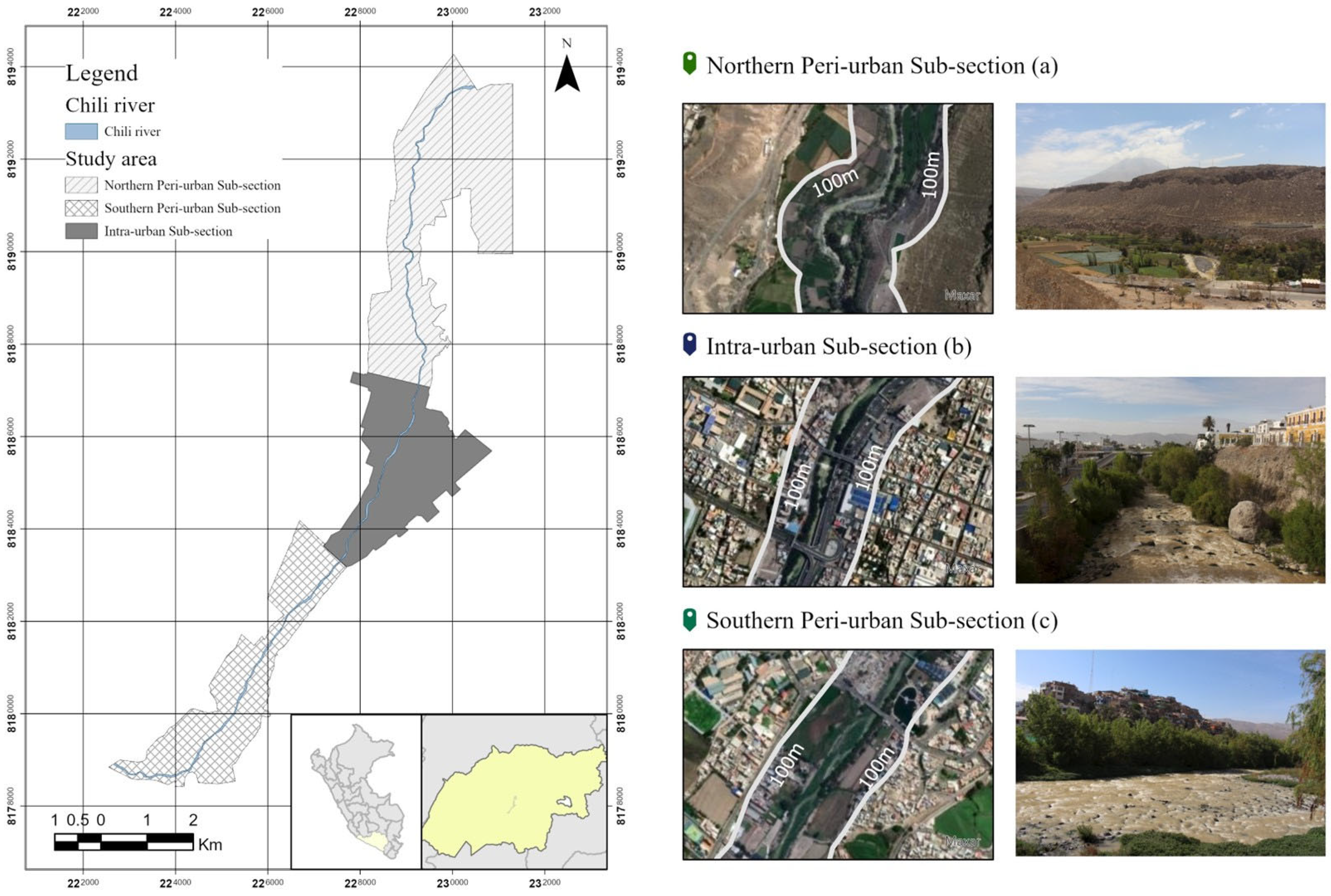
2.1. Study Area
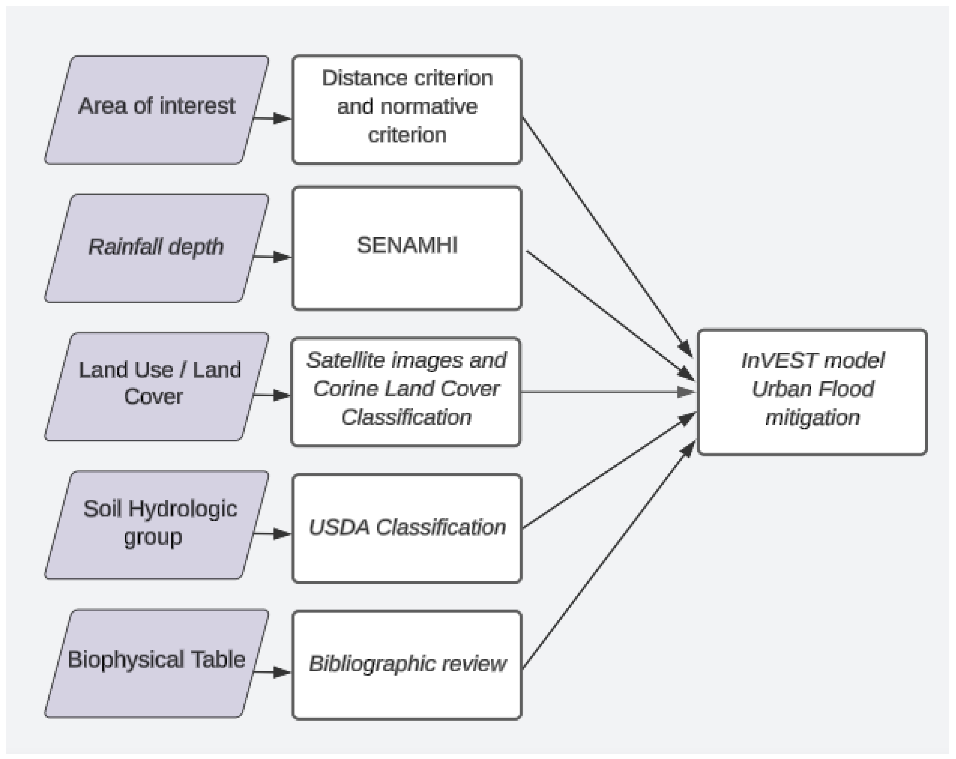
2.2. Methodolody
2.3. Rainfall Depth
2.4. Land Use/Land Cover
2.5. Hydrological Group of Soils (HGS)
2.6. Biophysical Table
2.7. Validation of Land Use Raster (Precision Analysis)
2.8. Urban Flood Risk Mitigation (UFRM) Model
- is the precipitation in mm.
- is the retention potential in mm.
- is the rainfall required to initiate runoff, and λ = 0.2.
- is a function of CN, which is an empirical parameter dependent on l and use (LUCL) and soil characteristics.
3. Results
4. Discussion
5. Conclusions
Author Contributions
Funding
Data Availability Statement
Conflicts of Interest
Appendix A. Hydrological Groups of Soils
| Classification of Hydrological Groups of Soils | |
|---|---|
| Group A | Soils with low runoff potential and high-water transmission rate (over 90% sand and <10% clay) |
| Group B | Soils with moderately low runoff potential and a moderate water transmission rate (between 10 and 20% clay and 50 and 90% sand) |
| Group C | Soils with moderately high runoff potential (between 20 and 40% clay and <50% sand) |
| Group D | Soils with high runoff potential and low transmission rate (over 40% clay and <50% sand) |
Appendix B. Accuracy Assessment of the LULC Rasters
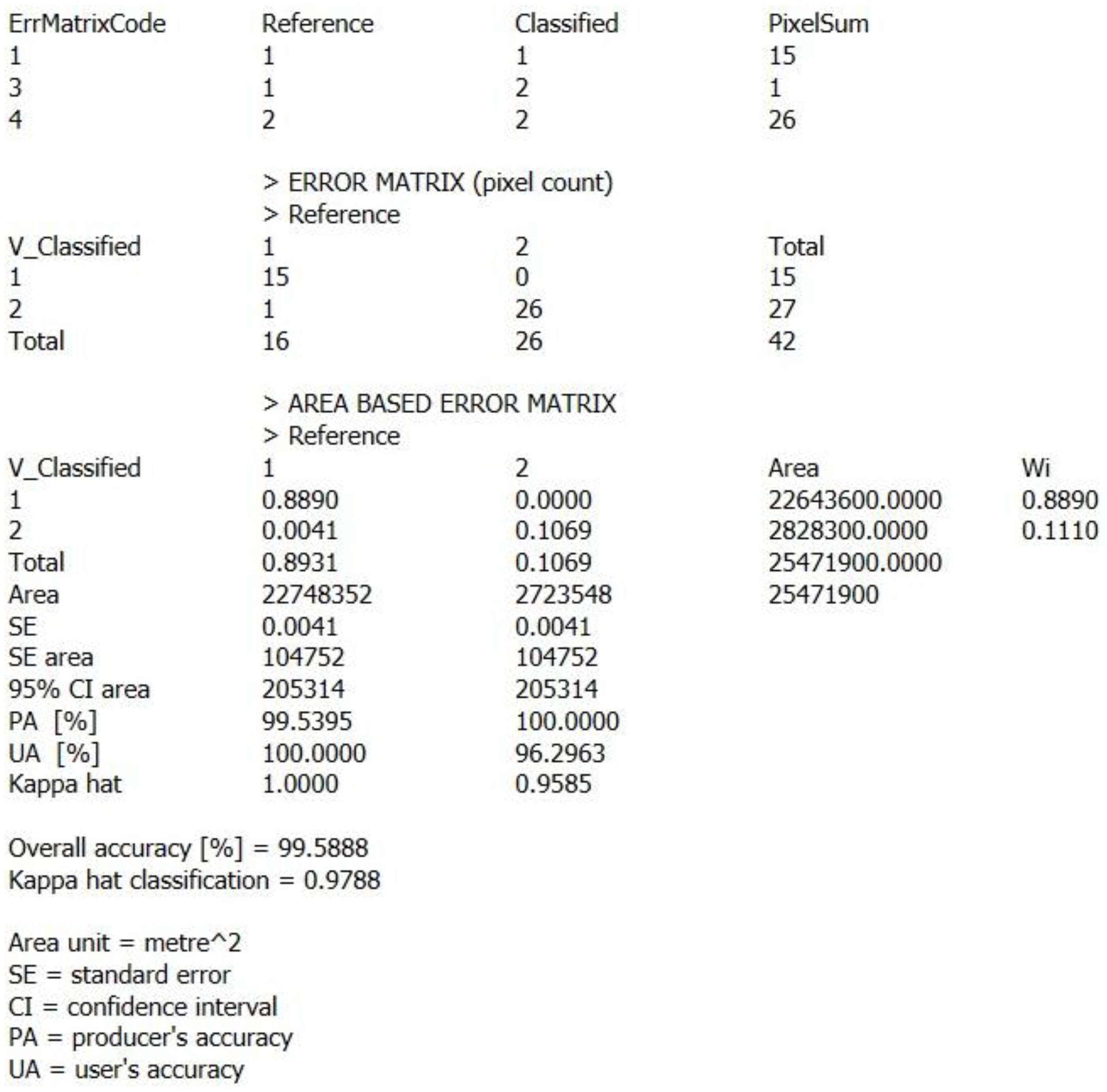
Appendix C. Accuracy Assessment of the Runoff (%) Raster Results
References
- Kumari, J.; Dessai, K.; Cardozo, Z.W.; Pereira, B.; Fernandes, R.; Sakhardande, A.; Mascarenhas, S. River Water Resource Management and Flood Control Using GIS. Lect. Notes Civ. Eng. 2021, 105, 373–379. [Google Scholar] [CrossRef]
- Bai, T.; Wei, J.; Yang, W.; Huang, Q. Multi-Objective Parameter Estimation of Improved Muskingum Model by Wolf Pack Algorithm and Its Application in Upper Hanjiang River, China. Water 2018, 10, 1415. [Google Scholar] [CrossRef]
- Wu, X.; Wang, Z.; Guo, S.; Lai, C.; Chen, X. A simplified approach for flood modeling in urban environments. Hydrol. Res. 2018, 49, 1804–1816. [Google Scholar] [CrossRef]
- Mileti, D.S.; Gailus, J.L. Sustainable development and hazards mitigation in the United States: Disasters by design revisited. Mitig Adapt. Strateg. Glob. Change 2005, 10, 491–504. [Google Scholar] [CrossRef]
- Hernández-Hernández, M.; Olcina, J.; Morote, Á.-F. Urban Stormwater Management, a Tool for Adapting to Climate Change: From Risk to Resource. Water 2020, 12, 2616. [Google Scholar] [CrossRef]
- Shanableh, A.; Al-Ruzouq, R.; Yilmaz, A.G.; Siddique, M.; Merabtene, T.; Alam Imteaz, M. Effects of Land Cover Change on Urban Floods and Rainwater Harvesting: A Case Study in Sharjah, UAE. Water 2018, 10, 631. [Google Scholar] [CrossRef]
- Richards, D.R.; Edwards, P.J. Using water management infrastructure to address both flood risk and the urban heat island. Int. J. Water Resour. Dev. 2017, 34, 490–498. [Google Scholar] [CrossRef]
- Qi, Y.; Chan, F.K.S.; Thorne, C.; O’donnell, E.; Quagliolo, C.; Comino, E.; Pezzoli, A.; Li, L.; Griffiths, J.; Sang, Y.; et al. Addressing Challenges of Urban Water Management in Chinese Sponge Cities via Nature-Based Solutions. Water 2020, 12, 2788. [Google Scholar] [CrossRef]
- Rosenzweig, B.; Ruddell, B.L.; McPhillips, L.; Hobbins, R.; McPhearson, T.; Cheng, Z.; Chang, H.; Kim, Y. Developing knowledge systems for urban resilience to cloudburst rain events. Environ. Sci. Policy 2019, 99, 150–159. [Google Scholar] [CrossRef]
- Li, J.; Wang, Z.; Lai, C. Severe drought events inducing large decrease of net primary productivity in mainland China during 1982–2015. Sci. Total Environ. 2020, 703, 135541. [Google Scholar] [CrossRef]
- Garg, V.; Aggarwal, S.P.; Gupta, P.K.; Nikam, B.R.; Thakur, P.K.; Srivastav, S.K.; Kumar, A.S. Assessment of land use land cover change impact on hydrological regime of a basin. Environ. Earth Sci. 2017, 76, 635. [Google Scholar] [CrossRef]
- Zeng, G.M.; Xie, Z.; Zhang, S.F.; Luo, X. Flood Disaster and Non-engineering Mitigation Measures in Dongting Lake in China. Water Int. 2001, 26, 185–190. [Google Scholar] [CrossRef]
- Debele, S.E.; Kumar, P.; Sahani, J.; Marti-Cardona, B.; Mickovski, S.B.; Leo, L.S.; Porcù, F.; Bertini, F.; Montesi, D.; Vojinovic, Z.; et al. Nature-based solutions for hydro-meteorological hazards: Revised concepts, classification schemes and databases. Environ. Res. 2019, 179, 108799. [Google Scholar] [CrossRef]
- Quagliolo, C.; Comino, E.; Pezzoli, A. Experimental Flash Floods Assessment Through Urban Flood Risk Mitigation (UFRM) Model: The Case Study of Ligurian Coastal Cities. Front. Water 2021, 3, 663378. [Google Scholar] [CrossRef]
- Liu, Z.; Cai, Y.; Wang, S.; Lan, F.; Wu, X. Small and Medium-Scale River Flood Controls in Highly Urbanized Areas: A Whole Region Perspective. Water 2020, 12, 182. [Google Scholar] [CrossRef]
- Pappalardo, V.; La Rosa, D.; Campisano, A.; La Greca, P. The potential of green infrastructure application in urban runoff control for land use planning: A preliminary evaluation from a southern Italy case study. Ecosyst. Serv. 2017, 26, 345–354. [Google Scholar] [CrossRef]
- Berndtsson, R.; Becker, P.; Persson, A.; Aspegren, H.; Haghighatafshar, S.; Jönsson, K.; Larsson, R.; Mobini, S.; Mottaghi, M.; Nilsson, J.; et al. Drivers of changing urban flood risk: A framework for action. J. Environ. Manag. 2019, 240, 47–56. [Google Scholar] [CrossRef]
- Hack, J.; Molewijk, D.; Beißler, M.R. A Conceptual Approach to Modeling the Geospatial Impact of Typical Urban Threats on the Habitat Quality of River Corridors. Remote Sens. 2020, 12, 1345. [Google Scholar] [CrossRef]
- Vásquez, A. Infraestructura verde, servicios ecosistémicos y sus aportes para enfrentar el cambio climático en ciudades: El caso del corredor ribereño del río Mapocho en Santiago de Chile. Rev. Geogr. Norte Gd. 2016, 63, 63–86. [Google Scholar] [CrossRef]
- Magdaleno, F.; Cortes, F.; Molina, B. Infraestructuras verdes y azules: Estrategias de adaptación y mitigación ante el cambio climático. Rev. Digit. Del Cedex 2018, 191, 105–112. [Google Scholar]
- Kadaverugu, A.; Rao, C.N.; Viswanadh, G.K. Quantification of flood mitigation services by urban green spaces using InVEST model: A case study of Hyderabad city, India. Model. Earth Syst. Environ. 2021, 7, 589–602. [Google Scholar] [CrossRef]
- Hunter, R.; Cleary, A.; Cleland, C.; Braubach, M. Urban Green Space Interventions and Health: A Review of Impacts and Effectiveness. Full Report; World Health Organization: Geneva, Switzerland, 2017; Available online: https://www.who.int/europe/publications/m/item/urban-green-space-interventions-and-health--a-review-of-impacts-and-effectiveness.-full-report (accessed on 9 March 2025).
- Soz, S.A.; Kryspin-Watson, J.; Stanton-Geddes, Z. The Role of Green Infrastructure Solutions in Urban Flood Risk Management; World Bank: Washington, DC, USA, 2016. [Google Scholar]
- Rao, V.G.; Surinaidu, L. Rain Gardens—A New Ecosystem in City Landscape for in situ Harvesting of Rain Water. Ecol. Environ. Group 2012, 80, 89–96. [Google Scholar]
- Jha, A.K.; Bloch, R.; Lamond, J. Cities and Flooding: A Guide to Integrated Urban Flood Risk Management for the 21st Century. In Cities and Flooding; World Bank: Washington, DC, USA, 2012. [Google Scholar] [CrossRef]
- Mazer, K.E.; Tomasek, A.A.; Daneshvar, F.; Bowling, L.C.; Frankenberger, J.R.; McMillan, S.K.; Novoa, H.M.; Zeballos-Velarde, C. Integrated Hydrologic and Hydraulic Analysis of Torrential Flood Hazard in Arequipa, Peru. J. Contemp. Water Res. Educ. 2020, 171, 93–110. [Google Scholar] [CrossRef]
- Wei, W.; Gong, J.; Deng, J.; Xu, W. Effects of Air Vent Size and Location Design on Air Supply Efficiency in Flood Discharge Tunnel Operations. J. Hydraul. Eng. 2023, 149, 04023050. [Google Scholar] [CrossRef]
- Hohermuth, B.; Boes, R.M.; Felder, S. High-Velocity Air–Water Flow Measurements in a Prototype Tunnel Chute: Scaling of Void Fraction and Interfacial Velocity. J. Hydraul. Eng. 2021, 147, 04021044. [Google Scholar] [CrossRef]
- Jiang, F.; Xu, W.; Deng, J.; Wei, W. Flow Structures of the Air-Water Layer in the Free Surface Region of High-Speed Open Channel Flows. Math. Probl. Eng. 2020, 2020, 5903763. [Google Scholar] [CrossRef]
- Garreaud, R.D. A plausible atmospheric trigger for the 2017 coastal El Niño. Int. J. Clim. 2018, 38, E1296–E1302. [Google Scholar] [CrossRef]
- Son, R.; Wang, S.-Y.S.; Tseng, W.-L.; Schuler, C.W.B.; Becker, E.; Yoon, J.-H. Climate diagnostics of the extreme floods in Peru during early 2017. Clim. Dyn. 2019, 54, 935–945. [Google Scholar] [CrossRef]
- Qi, X.; Qian, S.; Chen, K.; Li, J.; Wu, X.; Wang, Z.; Deng, Z.; Jiang, J. Dependence of daily precipitation and wind speed over coastal areas: Evidence from China’s coastline. Hydrol. Res. 2023, 54, 491–507. [Google Scholar] [CrossRef]
- Tian, Y.; Zhao, Y.; Li, J.; Xu, H.; Zhang, C.; Deng, L.; Wang, Y.; Peng, M. Improving CMIP6 Atmospheric River Precipitation Estimation by Cycle-Consistent Generative Adversarial Networks. J. Geophys. Res. Atmos. 2024, 129, e2023JD040698. [Google Scholar] [CrossRef]
- Zhang, K.; Li, Y.; Yu, Z.; Yang, T.; Xu, J.; Chao, L.; Ni, J.; Wang, L.; Gao, Y.; Hu, Y.; et al. Xin’anjiang Nested Experimental Watershed (XAJ-NEW) for Understanding Multiscale Water Cycle: Scientific Objectives and Experimental Design. Engineering 2022, 18, 207–217. [Google Scholar] [CrossRef]
- Zhao, Y.; Lu, M.; Zhang, L.; Cheng, T.F. Remote Influence of Southern Tibetan Plateau Heating on North Pacific Atmospheric Rivers. J. Clim. 2024, 38, 101–116. [Google Scholar] [CrossRef]
- Tian, Y.; Zhao, Y.; Son, S.; Luo, J.; Oh, S.; Wang, Y. A Deep-Learning Ensemble Method to Detect Atmospheric Rivers and Its Application to Projected Changes in Precipitation Regime. J. Geophys. Res. Atmos. 2023, 128, e2022JD037041. [Google Scholar] [CrossRef]
- Ettinger, S.; Mounaud, L.; Magill, C.; Yao-Lafourcade, A.-F.; Thouret, J.-C.; Manville, V.; Negulescu, C.; Zuccaro, G.; De Gregorio, D.; Nardone, S.; et al. Building vulnerability to hydro-geomorphic hazards: Estimating damage probability from qualitative vulnerability assessment using logistic regression. J. Hydrol. 2016, 541, 563–581. [Google Scholar] [CrossRef]
- Seenirajan, M.; Natarajan, M.; Thangaraj, R.; Bagyaraj, M. Study and Analysis of Chennai Flood 2015 Using GIS and Multicriteria Technique. J. Geogr. Inf. Syst. 2017, 09, 126–140. [Google Scholar] [CrossRef][Green Version]
- Nikonorov, A.; Badenko, V.; Terleev, V.; Togo, I.; Volkova, Y.; Skvortsova, O.; Nikonova, O.; Pavlov, S.; Mirschel, W. Use of GIS-environment under the Analysis of the Managerial Solutions for Flood Events Protection Measures. Procedia Eng. 2016, 165, 1731–1740. [Google Scholar] [CrossRef]
- Isma’il, M.; Saanyol, I.O. Application of Remote Sensing (RS) and Geographic Information Systems (GIS) in flood vulnerability mapping: Case study of River Kaduna. Int. J. Geomat. Geosci. 2013, 3, 618–628. [Google Scholar]
- Li, Y.; Ji, C.; Wang, P.; Huang, L. Proactive intervention of green infrastructure on flood regulation and mitigation service based on landscape pattern. J. Clean. Prod. 2023, 419, 138152. [Google Scholar] [CrossRef]
- Gaňová, L.; Zeleňáková, M.; Purcz, P.; Diaconu, D.C.; Orfánus, T.; Kuzevičová, Ž. Identification of urban flood vul-nerability in eastern Slovakia by mapping the potential natural sources of flooding—Implications for territorial planning. Urban. Archit. Constr. 2017, 8, 365–376. [Google Scholar]
- Hamel, P.; Tan, L. Blue–Green Infrastructure for Flood and Water Quality Management in Southeast Asia: Evidence and Knowledge Gaps. Environ. Manag. 2021, 69, 699–718. [Google Scholar] [CrossRef]
- Esse, C.; Santander-Massa, R.; Encina-Montoya, F.; Ríos, P.D.L.; Fonseca, D.; Saavedra, P. Multicriteria spatial analysis applied to identifying ecosystem services in mixed-use river catchment areas in south central Chile. For. Ecosyst. 2019, 6, 25. [Google Scholar] [CrossRef]
- Kharytonov, M.M.; Pugach, A.M.; Stankevich, S.A.; Kozlova, A.O. Geospatial assessment of the Mokra Sura river ecological condition using remote sensing and in situ monitoring data. J. Geol. Geogr. Geoecol. 2019, 27, 422–430. [Google Scholar] [CrossRef] [PubMed]
- Lüke, A.; Hack, J. Comparing the Applicability of Commonly Used Hydrological Ecosystem Services Models for Integrated Decision-Support. Sustainability 2018, 10, 346. [Google Scholar] [CrossRef]
- Francesconi, W.; Srinivasan, R.; Pérez-Miñana, E.; Willcock, S.P.; Quintero, M. Using the Soil and Water Assessment Tool (SWAT) to model ecosystem services: A systematic review. J. Hydrol. 2016, 535, 625–636. [Google Scholar] [CrossRef]
- Schmalz, B.; Kruse, M.; Kiesel, J.; Müller, F.; Fohrer, N. Water-related ecosystem services in Western Siberian lowland basins—Analysing and mapping spatial and seasonal effects on regulating services based on ecohydrological modelling results. Ecol. Indic. 2016, 71, 55–65. [Google Scholar] [CrossRef]
- Bagstad, K.J.; Semmens, D.J.; Winthrop, R. Comparing approaches to spatially explicit ecosystem service modeling: A case study from the San Pedro River, Arizona. Ecosyst. Serv. 2013, 5, 40–50. [Google Scholar] [CrossRef]
- Natural Capital Project, 2025. InVEST 0.0. Stanford University, University of Minnesota, Chinese Academy of Sciences, The Nature Conservancy, World Wildlife Fund, Stockholm Resilience Centre and the Royal Swedish Academy of Sciences. Available online: https://naturalcapitalproject.stanford.edu/software/invest (accessed on 23 March 2025).
- Bose, S.; Mazumdar, A. Urban flood risk assessment and mitigation with InVEST-UFRM model: A case study on Kolkata city, West Bengal state (India). Arab. J. Geosci. 2023, 16, 320. [Google Scholar] [CrossRef]
- Collyns, D. How can Peru prepare to withstand more devastating floods and landslides? Working in development. The Guardian. 2017. Available online: https://www.theguardian.com/global-development-professionals-network/2017/apr/13/peru-prevent-floods-landslides-climate-change (accessed on 23 March 2025).
- Parida, Y. Economic impact of floods in the Indian states. Environ. Dev. Econ. 2019, 25, 267–290. [Google Scholar] [CrossRef]
- Sayers, P.; Penning-Rowsell, E.C.; Horritt, M. Flood vulnerability, risk, and social disadvantage: Current and future patterns in the UK. Reg. Environ. Chang. 2018, 18, 339–352. [Google Scholar] [CrossRef]
- Fernández-Dávila, J.; Benites, A. Inundaciones En La Localidad de Arequipa Ocasionadas Por El Ingreso de Las Torrenteras; Instituto Nacional de Defensa Civil. INDECI: Arequipa, Peru, 1999.
- Libélula, C. Vulnerabilidad y Adaptación al Cambio Climático en Arequipa Metropolitana; CAF: Lima, Peru, 2018; Available online: https://scioteca.caf.com/handle/123456789/1181 (accessed on 11 March 2025).
- Montesinos-Tubée, D.B.; del Prado, H.N.; Bustamante, B.J.T.; Tejada, E.M.Á.; Lozada, A.B.; Flores, J.Z.; Paco, G.G.; Maldonado, M.; Moscoso, M.d.P.R.; Arteaga, G.C.R.; et al. Diversidad florística, comunidades vegetales y propuestas de conservación del monte ribereño en el río Chili (Arequipa, Perú). Arnaldoa 2019, 26, 97–130. [Google Scholar] [CrossRef]
- Llanque, J. Planificación y Diseño Bioclimático. Estrategias Para la Recuperación del Espacio Público, Edición Dongo; Universidad Nacional de San Agustín de Arequipa: Arequipa, Peru, 2004. [Google Scholar]
- Marengo, J.; Obregón, G.; Ramírez, V. Cambio Climático En Arequipa: Impactos, Evaluaciones de Vulnerabilidad y Medidas de Adaptación; Cachoeira Paulista: São Paulo, Brasil, 2008. [Google Scholar]
- Carrasco-Valencia, L.; Vilca-Campana, K.; Iruri-Ramos, C.; Cárdenas-Pillco, B.; Ollero, A.; Chanove-Manrique, A. Effect of LULC Changes on Annual Water Yield in the Urban Section of the Chili River, Arequipa, Using the Invest Model. Water 2024, 16, 664. [Google Scholar] [CrossRef]
- Vian, F.D.; Izquierdo, J.J.P.; Martínez, M.S. ¿Qué es un río urbano? Propuesta metodológica para su delimitación en España. ACE Archit. City Environ. 2020, 15, 1–30. [Google Scholar] [CrossRef]
- Instituto Municipal de Planeamiento. Memoria del PDM Arequipa Plan de Desarrollo Metropolitano de Arequipa 2016–2025; Ordenanza Municipal: Arequipa, Peru, 2016. Available online: http://impla.gob.pe/publicaciones/pdm-2016-2025/ (accessed on 1 June 2021).
- Dirección de Calidad y Evaluación de Recursos Hídricos. Estudio Hidrogeológico del Acuífero del Río Chili; Autoridad Nacional del Agua: Arequipa, Peru, 2018.
- Mishra, S.K.; Singh, V.P. Validity and extension of the SCS-CN method for computing infiltration and rainfall-excess rates. Hydrol. Process. 2004, 18, 3323–3345. [Google Scholar] [CrossRef]
- Aybar Camacho, C.L.; Lavado-Casimiro, W.; Huerta, A.; Fernández Palomino, C.; Vega-Jácome, F.; Sabino Rojas, E.; Felipe-Obando, O. Uso del Producto Grillado PISCO de Precipitación en Estudios, Investigaciones y Sistemas Operacionales de Monitoreo y pro-Nóstico Hidrometeorológico; SENAMHI: Lima, Peru, 2017.
- HEC-HMS Technical Reference Manual/CN Tables. Available online: https://www.hec.usace.army.mil/confluence/hmsdocs/hmstrm/cn-tables (accessed on 11 March 2025).
- EarthExplorer. Available online: https://earthexplorer.usgs.gov (accessed on 10 June 2017).
- Copernicus Browser. Available online: https://browser.dataspace.copernicus.eu/?zoom=5&lat=50.16282&lng=20.78613&themeId=DEFAULT-THEME&visualizationUrl=U2FsdGVkX19r845AJpS7mU3bLzdH2zht3wp%2Fe%2FQHiRFA411pmjPUHDcuxvjm35DgJDrNDhjPyEA61jjHpK6LTmn%2Fc9UKPMEtDlYSOj07GVl3lyRQ7IWLH8yb1zXoR0Ak&datasetId=S2_L2A_CDAS&demSource3D=%22MAPZEN%22&cloudCoverage=30&dateMode=SINGLE (accessed on 11 March 2025).
- Ross, C.W.; Prihodko, L.; Anchang, J.; Kumar, S.; Ji, W.J.; Hanan, N.P. Global Hydrologic Soil Groups (HYSOGs250m) for Curve Number-Based Runoff Modeling. Sci. Data 2018, 5, 180091. [Google Scholar] [CrossRef] [PubMed]
- Thouret, J.-C.; Enjolras, G.; Martelli, K.; Santoni, O.; Luque, J.A.; Nagata, M.; Arguedas, A.; Macedo, L. Combining criteria for delineating lahar- and flash-flood-prone hazard and risk zones for the city of Arequipa, Peru. Nat. Hazards Earth Syst. Sci. 2013, 13, 339–360. [Google Scholar] [CrossRef]
- Daneshvar, F.; Frankenberger, J.R.; Bowling, L.C.; Cherkauer, K.A.; Moraes, A.G.d.L. Development of Strategy for SWAT Hydrologic Modeling in Data-Scarce Regions of Peru. J. Hydrol. Eng. 2021, 26, 05021016. [Google Scholar] [CrossRef]
- Ochoa-Tocachi, B.F.; Buytaert, W.; Antiporta, J.; Acosta, L.; Bardales, J.D.; Célleri, R.; Crespo, P.; Fuentes, P.; Gil-Ríos, J.; Guallpa, M.; et al. High-resolution hydrometeorological data from a network of headwater catchments in the tropical Andes. Sci. Data 2018, 5, 180080. [Google Scholar] [CrossRef]

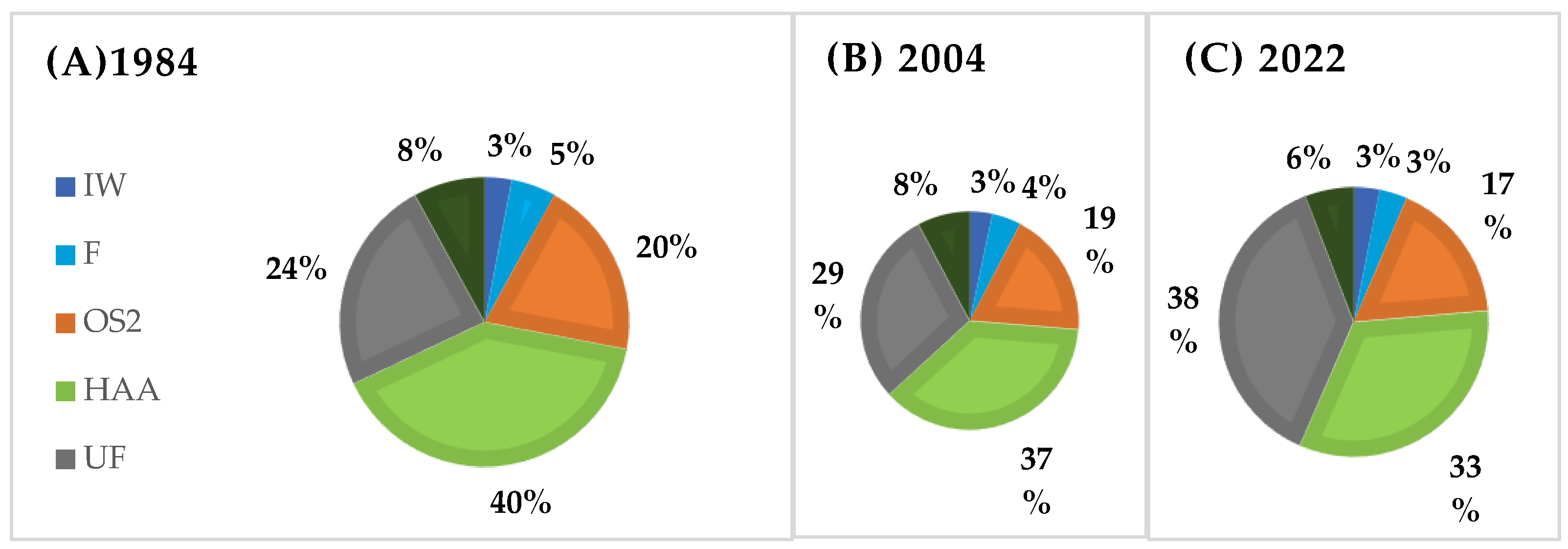
| LULC Classes | Abbreviation |
|---|---|
| Inland waters (river) | IW |
| Forest (riparian forest) | F |
| Open spaces 1 (Cardonal) | OS1 |
| Heterogeneous agricultural areas (agriculture) | HAA |
| Urban fabric (urban) | UF |
| Open spaces 2 (Puyal) | OS2 |
| LULC Class Type | Lucode | CN_A | CN_B | CN_C | CN_D |
|---|---|---|---|---|---|
| IW | 1 | 1 | 1 | 1 | 1 |
| F | 2 | 63 | 74 | 82 | 85 |
| OS1 | 3 | 71 | 72 | 73 | 74 |
| HAA | 4 | 68 | 79 | 86 | 89 |
| UF | 5 | 63 | 77 | 85 | 88 |
| OS2 | 6 | 49 | 46 | 48 | 47 |
| Model Input | Detail | Source |
|---|---|---|
| Rainfall depth | 10 × 10 m | SENAMHI [65] |
| Land use/land cover | 30 × 30 m (Landsat 5) 10 × 10 m (Sentinel-2) | Earth Explorer Platform [67], Copernicus program [68] |
| Soil Hydrologic group | 10 × 10 m | USDA Classification [69] |
| Biophysical Table | CSV file | InVEST user manual [50] and bibliographic review [66] |
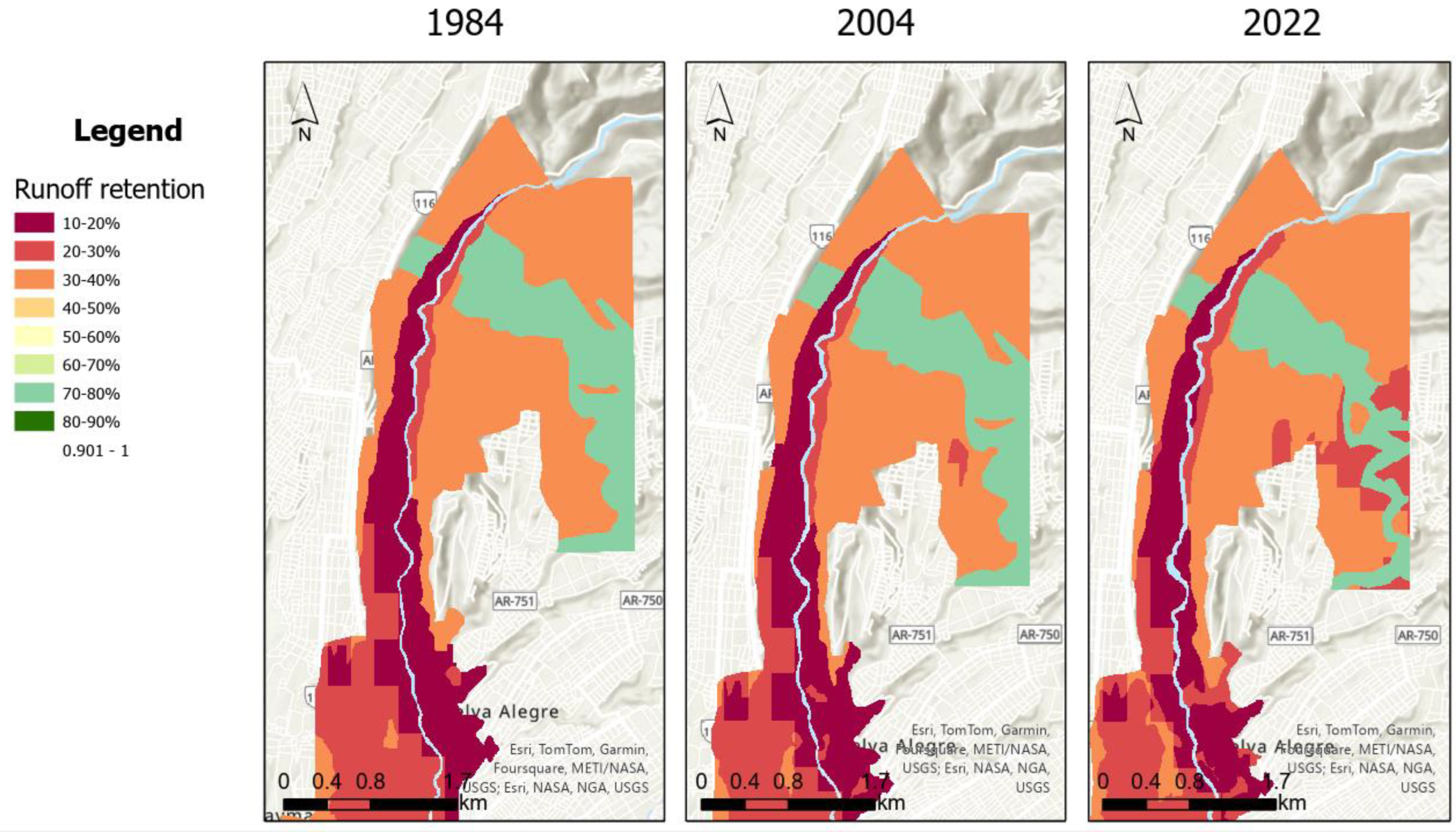
| Year | Runoff Retention (%) | Runoff Retention (m3) | Runoff (m3) |
|---|---|---|---|
| 1984 | 33.33 | 7.50 | 149.99 |
| 1988 | 33.25 | 7.48 | 150.18 |
| 1992 | 33.51 | 7.54 | 149.59 |
| 1996 | 33.77 | 7.59 | 149.01 |
| 2000 | 34.12 | 7.67 | 148.22 |
| 2004 | 34.09 | 7.67 | 148.29 |
| 2008 | 33.74 | 7.59 | 149.08 |
| 2013 | 32.75 | 7.37 | 151.29 |
| 2017 | 31.88 | 7.17 | 153.26 |
| 2022 | 32.38 | 7.28 | 152.13 |
| Average | 33.28 | 7.48 | 150.11 |
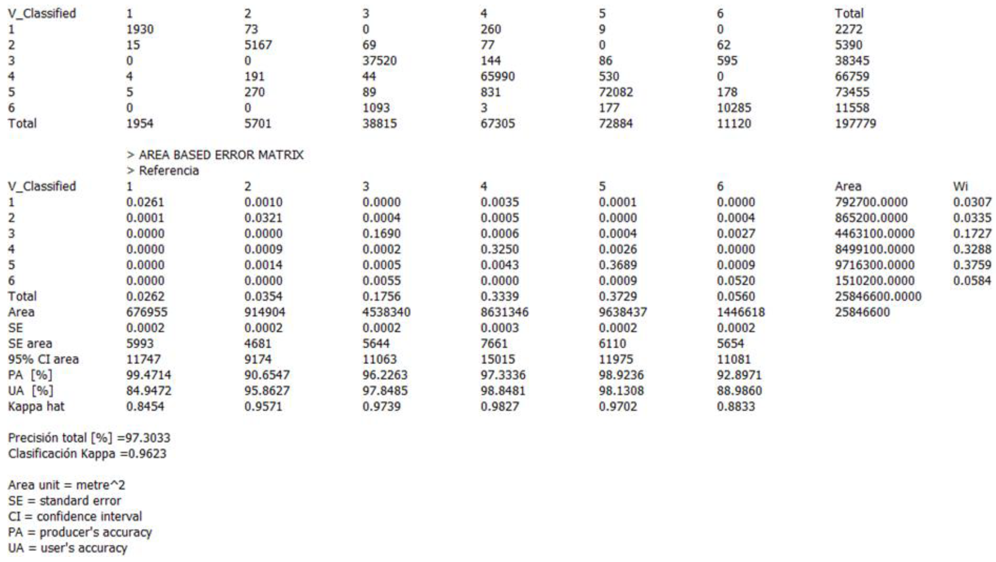
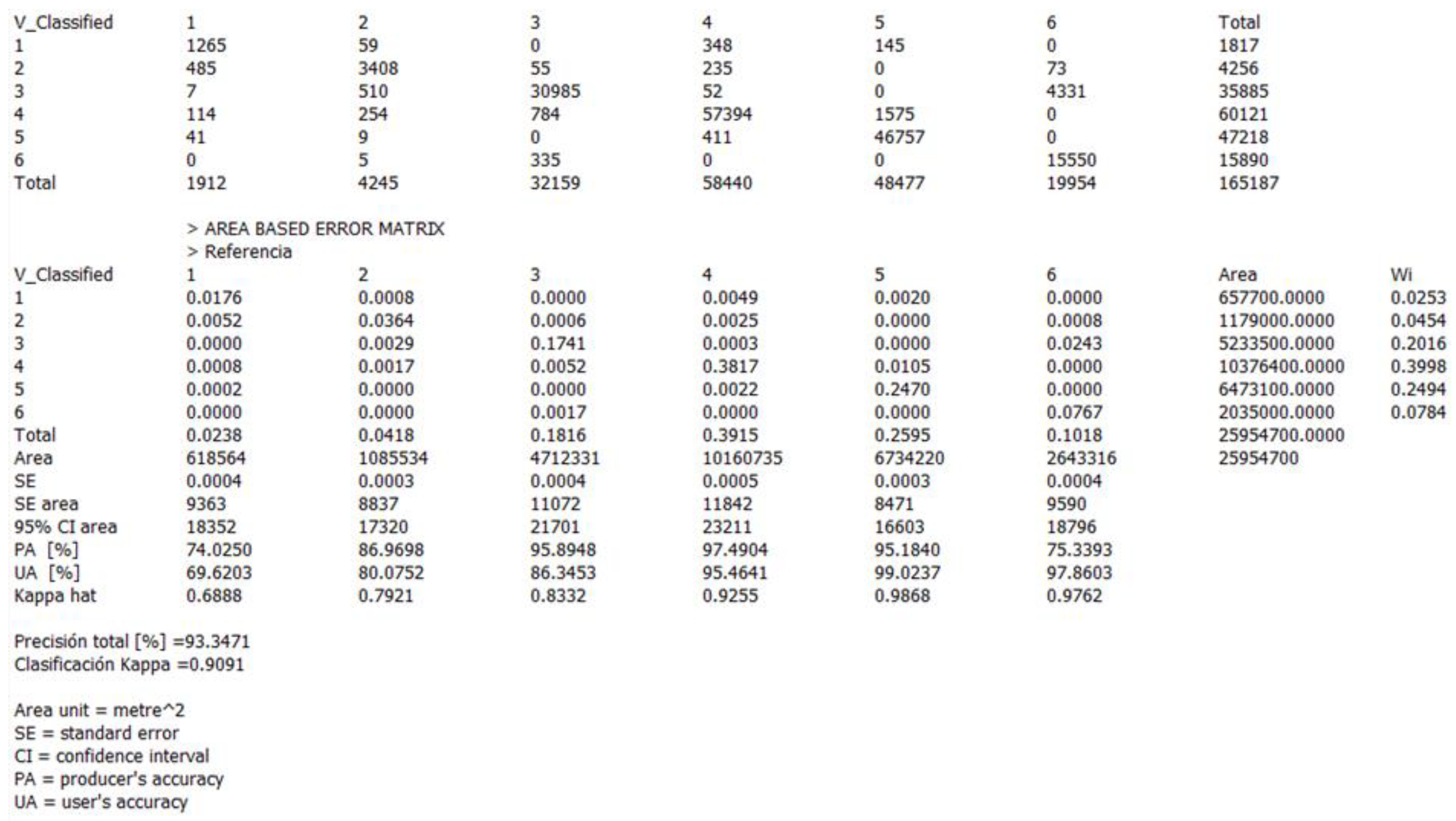
| Year | Accuracy | IW | F | OS1 | HAA | UF | OS2 |
|---|---|---|---|---|---|---|---|
| 1984 | SE | 0.0004 | 0.0003 | 0.0004 | 0.0005 | 0.0003 | 0.0004 |
| SE area | 9363 | 8837 | 11,072 | 11,842 | 8471 | 9590 | |
| 95%CI area | 18,352 | 17,320 | 21,701 | 23,211 | 16,603 | 18,796 | |
| PA (%) | 74.03 | 86.97 | 95.89 | 97.49 | 95.18 | 75.34 | |
| UA (%) | 69.62 | 80.07 | 86.35 | 95. 46 | 99.02 | 97.86 | |
| Kappa hat | 0.6888 | 0.7921 | 0.8332 | 0.9255 | 0.9868 | 0.9762 | |
| OA (%) | 93.35 | ||||||
| Kappa Classification | 0.9091 | ||||||
| 2022 | SE | 0.0002 | 0.0002 | 0.0002 | 0.0003 | 0.0002 | 0.0002 |
| SE area | 5993 | 4681 | 5644 | 7661 | 6110 | 5654 | |
| 95%CI area | 11,747 | 9174 | 11,063 | 15,015 | 11,975 | 11,081 | |
| PA (%) | 99.47 | 90.65 | 96.23 | 97.33 | 98.29 | 92.90 | |
| UA (%) | 84.95 | 95.86 | 97.85 | 98.85 | 98.13 | 88.99 | |
| Kappa hat | 0.8454 | 0.9571 | 0.9739 | 0.9827 | 0.9702 | 0.8833 | |
| OA (%) | 97.30 | ||||||
| Kappa Classification | 0.9623 | ||||||
Disclaimer/Publisher’s Note: The statements, opinions and data contained in all publications are solely those of the individual author(s) and contributor(s) and not of MDPI and/or the editor(s). MDPI and/or the editor(s) disclaim responsibility for any injury to people or property resulting from any ideas, methods, instructions or products referred to in the content. |
© 2025 by the authors. Licensee MDPI, Basel, Switzerland. This article is an open access article distributed under the terms and conditions of the Creative Commons Attribution (CC BY) license (https://creativecommons.org/licenses/by/4.0/).
Share and Cite
Vilca-Campana, K.; Carrasco-Valencia, L.; Iruri-Ramos, C.; Cárdenas-Pillco, B.; Escudero, A.; Chanove-Manrique, A. Improving Urban Flood Resilience: Urban Flood Risk Mitigation Assessment Using a Geospatial Model in the Urban Section of a River Corridor. Water 2025, 17, 1047. https://doi.org/10.3390/w17071047
Vilca-Campana K, Carrasco-Valencia L, Iruri-Ramos C, Cárdenas-Pillco B, Escudero A, Chanove-Manrique A. Improving Urban Flood Resilience: Urban Flood Risk Mitigation Assessment Using a Geospatial Model in the Urban Section of a River Corridor. Water. 2025; 17(7):1047. https://doi.org/10.3390/w17071047
Chicago/Turabian StyleVilca-Campana, Karla, Lorenzo Carrasco-Valencia, Carla Iruri-Ramos, Berly Cárdenas-Pillco, Adrián Escudero, and Andrea Chanove-Manrique. 2025. "Improving Urban Flood Resilience: Urban Flood Risk Mitigation Assessment Using a Geospatial Model in the Urban Section of a River Corridor" Water 17, no. 7: 1047. https://doi.org/10.3390/w17071047
APA StyleVilca-Campana, K., Carrasco-Valencia, L., Iruri-Ramos, C., Cárdenas-Pillco, B., Escudero, A., & Chanove-Manrique, A. (2025). Improving Urban Flood Resilience: Urban Flood Risk Mitigation Assessment Using a Geospatial Model in the Urban Section of a River Corridor. Water, 17(7), 1047. https://doi.org/10.3390/w17071047


