Article

Potential of Fish Habitat Resilience Under Hydrodynamic Regulation of a Plain Urban River Network in Shanghai City, China

1
School of Civil Engineering, Yantai University, Yantai 264005, China
2
Provincial Lab of Water-Sand Regulation and Ecological Environment Remediation, Yantai University, Yantai 264005, China
3
Hydraulic Engineering Department, Nanjing Hydraulic Research Institution, Nanjing 210029, China
*
Author to whom correspondence should be addressed.
Water 2025, 17(6), 817; https://doi.org/10.3390/w17060817
Submission received: 16 January 2025 / Revised: 8 March 2025 / Accepted: 9 March 2025 / Published: 12 March 2025

Abstract

:
Cities in plain areas have small slopes at the bottoms of rivers, with weak hydrodynamics, heavy pollution and poor self-purification capacities for the restoration of biological habitats. Hydrodynamic and water quality improvements are effective means for the ecological restoration of plain urban rivers. The potential for fish habitat resilience in a typical urban river network plain (more than 130 river sections) in the Dianbei part of China was studied. The tolerant fish, Carassius auratus (C. auratus), and the sensitive fishes Trachidermus fasciatus (T. fasciatus) and Anguilla japonica (A. japonica), were selected as the protection targets, and hydrodynamic factors, river morphology and water quality factors were chosen as environmental indicators. With the fish habitat suitability index, a fish habitat resilience potential evaluation model was established. The response of the habitat resilience potential index (HRPI) to hydrodynamic regulation was subsequently analyzed, and the HRPI indicated an increased habitat resilience potential with its value increasing from 0 to 1. Overall, the resilience potential of tolerant fish species was greater than that of sensitive species in the Dianbei. For the HRPI of C. auratus adults (tolerant species), approximately 62.8% of the river sections were above 0.6 (high resilience level) and were concentrated in the northwest area of the river network. While for the resilience potential of A. japonica adults and T. fasciatus adults (sensitive species), only 60% of the river sections exhibited moderate resilience level (HRPI > 0.5). The average dimensionless habitat resilience potential index (AHRPI) was enhanced by water diversion with its values increased by 10.3%, 9.3% and 12.7% for C. auratus adults, T. fasciatus adults and A. japonica adults, respectively. The habitat resilience potential of C. auratus changed little during the spawning period, which indicated that the effect of hydrodynamic regulation was limited. This study provides a scientific basis for managers to restore urban river network habitats in plain areas.

1. Introduction

River ecosystems function in regulating climate, maintaining hydrological cycles and nutrient cycles and providing primary production [1]. Urban rivers refer to rivers or river sections that originate within a city or flow through a city, and are usually adapted from natural rivers. Urban rivers have the strongest function in the coordination of human activities and natural processes [2,3]. Human disturbances to rivers, including river channelization or constraints by sluice pumps, are increasing with urbanization [4,5]. This type of disturbance changes hydrodynamics, deteriorates water quality, and decreases the stability of urban river ecosystems [6,7]. The rivers located in plain areas are particularly impacted by urbanization due to the dense population and developed industry.
In China, most plain river network areas are highly urbanized, and their water environment and ecological problems are serious [8]. Flat plain terrain and small slopes at the river bottom result in small water level differences, weak hydrodynamic conditions, and backflow and overflow in plain river networks [9,10,11,12]. The spatial structure diversity of the river network is weakened, simplifying the exchange between urban rivers and surrounding ecosystems [13]. In densely populated areas, only a few very long rivers remain free-flowing [14], and many hydraulic structures, such as gates and pumping stations, exist in urbanized areas. The flow of water bodies is easily affected by dispatching, and the river system becomes disordered [15], decreasing the self-purification ability of the river [16]. The pollutant loads from rain-washing runoff on impervious surfaces and the overall flow of combined sewers in urbanized areas are usually high [17,18,19]. The loss of river species diversity is caused by species-regional effects associated with urbanization [20], hindering the restoration of biological habitats such as those of river fish.
The main strategies for ecological restoration in plain urban rivers include reducing the pollutant load, replenishing water, and remediating the environment [21]. Water replenishment by means of water diversion projects is one of the most frequently used technologies to improve the water quality of urban rivers [22]. Water diversion has been implemented in many urban rivers, such as the Sumida River in Tokyo, the Seonakdong River in Korea, and the Severn and Thames rivers in Britain [23,24]. In China, water diversion has been applied in Taihu Lake, the Pearl River and other areas [25,26,27]. Hydrodynamic regulation through the joint dispatch of sluice pumps has also been applied in plain urban river networks, significantly improving hydrodynamic conditions and water quality [24,28,29]. On the one hand, the hydrodynamic characteristics of plain river networks, such as water velocity and water level, improved quickly because of hydrodynamic regulation. On the other hand, the river re-oxygenation ability was enhanced, thereby increasing the pollutant degradation rate. The diffusion and dilution of pollutants were also promoted through water diversion [30].
At present, most evaluations of the effects of hydrodynamic regulation engineering have focused on improving water quality [31,32,33], while the resilience potential of fish habitats with improved hydrodynamic environments has been less addressed [34,35]. To more easily consider nonlinear dynamics in observable ecosystems, the concept of “resilience” was introduced into ecology by Holling in 1973 for the first time; that is, the capacity of a system to recover and return to its original state under pressure [36]. Over time, studies on resilience have been carried out; however, the concept is unclear, and resilience is divided into engineering resilience and ecological resilience [37]. The habitat resilience potential was quantified through continuous ecosystem modelling studies, and new criteria were added based on their own research characteristics and tendencies [38,39]. The habitat resilience potential will be induced and applied in this study.
Considering the weak hydrodynamic power, poor water quality, destruction of biological habitats and many hydrodynamic regulation projects in plain urban rivers, characterizing the impact of hydrodynamic regulation on the ecological restoration of fish habitats is necessary. In this study, the following three steps were taken: (1) establish a model for fish habitat restoration potential to evaluate river health; (2) explore the effects of hydrodynamics on fish habitat restoration potential; and (3) identify key factors limiting fish habitat restoration.

2. Materials and Methods
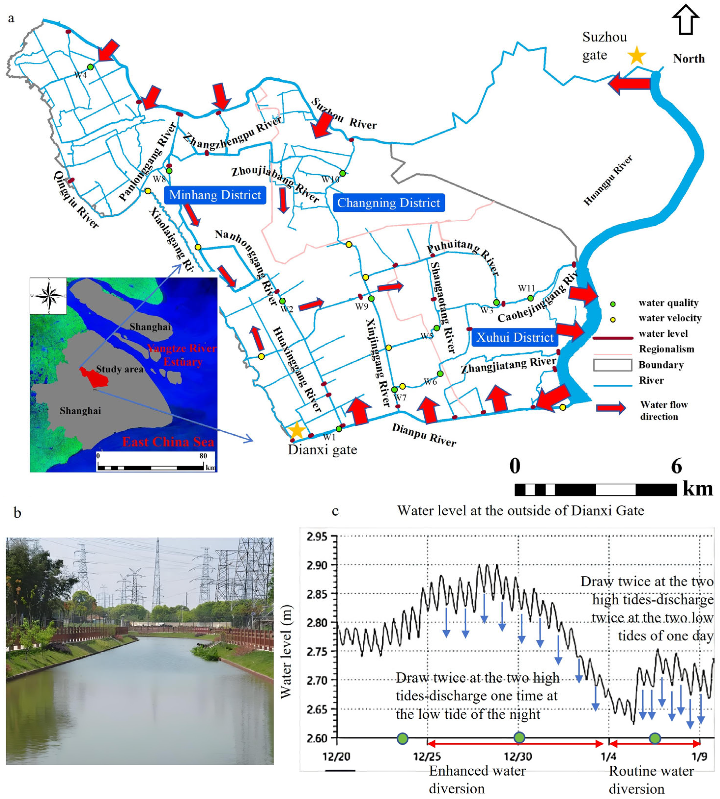
2.1. Study Area

The study area is the urban river network plain in the Dianbei part of Shanghai (31°7′~31°16′ N, 121°15′~121°28′ E), which is one of the 14 water conservation parts in Shanghai. With the Dianpu River and Suzhou River as the north-south boundaries, and the Xiaolaigang River as the west boundary, all the rivers flow into the Huanpu River (Figure 1a). The study area is approximately 163.35 km2 with a population of approximately four million people, and it is located in the central area of Shanghai city. Gates and flinty riverbanks have been built in all the major rivers; some riverbanks have been overrun, and the water-crossing sections are narrow in the river network (Figure 1b). Small fishes, such as Gambusia affinis and Belontiidae, which can live in surface waters for a long time, have appeared in the studied rivers.

2.2. Water Diversion, Monitoring Programs and Data Collection

The water diversion was mainly driven by the tidal power of the Huangpu River, which is a tidally influenced river that injects into the East China Sea. The tidal rhythm both provides the required water and the power for water movement. The enhanced water diversion was conducted in Dianbei from 25 December 2015 to 4 January 2016. Water was drawn from the Suzhou River of the northern boundary and the Dianpu River of the southern boundary at the two high tides until the water level reached 3.5 m above sea level inside the gates in the Suzhou River, with the water gates along the Huanpu River of the eastern boundary locked. Water was drained once at the second low tide, with the water gates along the Huanpu River opening (Figure 1c). Routine water diversion was conducted from 4 January to 8 January 2016. Water was drawn from the Suzhou River and the Dianpu River at the two high tides until a water level of 3.1 m was reached at the inside of the gates in the Suzhou River, with the water gates along the Huanpu River of the eastern boundary locked. Water was drained twice at the two low tides with the water gates along the Huanpu River opened.
Hydrological and hydrodynamic data, including data on the operation of the fifteen sluice-pump stations, water level, and flow velocity, were continuously collected by the local water conservancy bureau during the period of water diversion to validate the hydrodynamic model. Water samples at eleven sample sites were collected across the river network (Figure 1). Water samples were collected on 24 December (before water diversion) 2015, 30 December 2015 (enhanced water diversion), and 7 January 2016 (routine water diversion) to evaluate the improvement in water quality caused by enhanced water diversion. At each sampling site, a surface water sample was taken at 0.5–1.0 m depth underwater using a 5 L Plexiglas water sampler, and the water samples were stored in an icebox, brought to the laboratory, and analyzed immediately. The analyzed water parameters included dissolved oxygen (DO), ammonia nitrogen (NH3-N), the permanganate index (CODMn), and total phosphorus (TP). The DO concentration was monitored on site via portable YSI electrodes (Xylem Co. New York, NY, USA), and the NH3-N concentration was detected via ion chromatography (ICS-2000, Dionex Company, Sunnyvale, CA, USA). The CODMn was determined via back titration with organic matter in raw water samples oxidized by potassium permanganate. The TP concentration was determined via the acid-molybdenum-blue colorimetric method with persulfate digestion of raw water samples.
Geographic data was also collected from 1:2000 electronic maps and digital elevation models (DEMs), high-precision remote sensing images or aerial photographs and land use maps of the research area in 2015. The fish data was collected from the Fishes Compendium in Shanghai, fishery resource monitoring reports from the Institute of Hydrobiology of the Chinese Academy of Sciences, and Shanghai Ocean University. The fish catalogs include national or local protected species, rare and endangered species, endemic species, long-distance migratory fishes, and other protection targets. The life stage of fish species has also been described in the Fishes Compendium fishery resource monitoring reports.

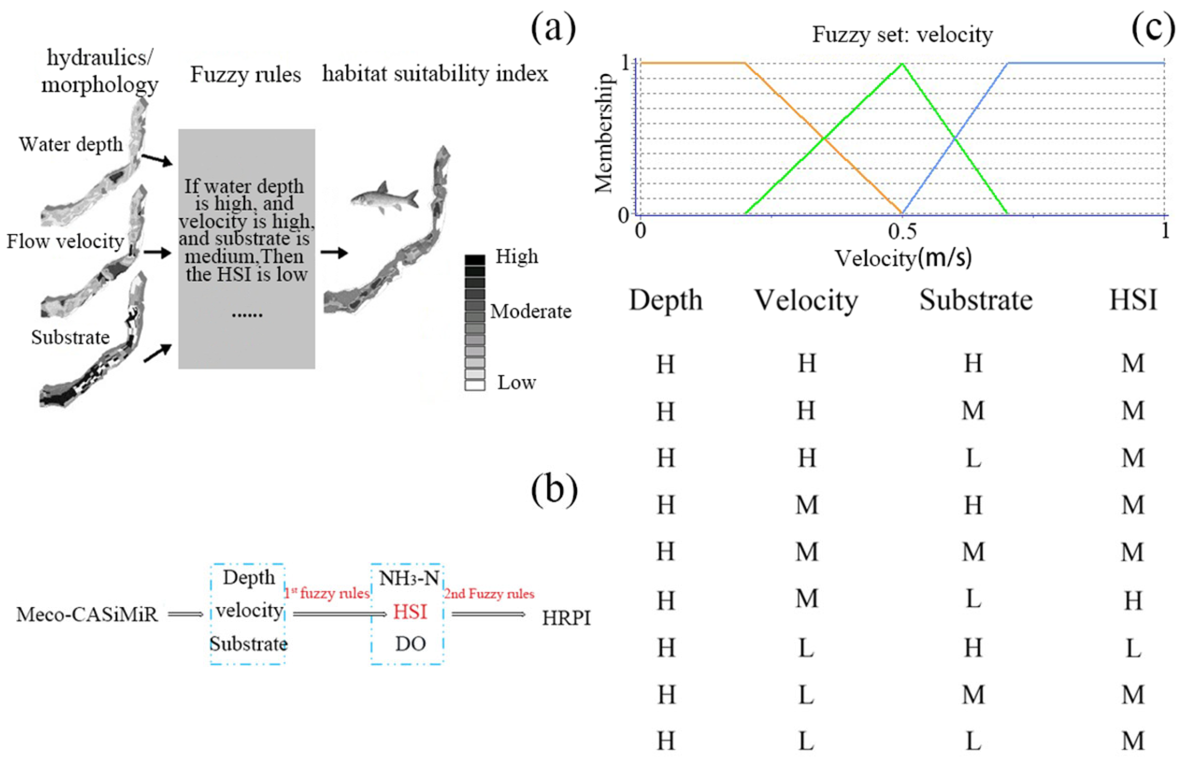
2.3. Evaluation Model for Fish Habitat Restoration Potential

2.3.1. Indicator Species

Fish can indicate the stages of river ecological restoration. In general, common fishes are considered to be characteristic fishes during river ecological restoration, and local sensitive fishes that have appeared before but disappeared are considered characteristic fishes in the future stage of restoration. One of local tolerant fish species, C. auratus, was selected as the targeted species for fish habitat restoration. With respect to the survival of local sensitive fish species in Shanghai, T. fasciatus and Anguilla japonica (A. japonica) were selected. T. fasciatus and A. japonica have been found to enter the sea to reproduce from freshwater rivers and then migrate upstream to freshwater rivers for growth. Therefore, three fish indicator species were selected: (1) the tolerant fish C. auratus (spawning and feeding period), and (2) the sensitive fish T. fasciatus (adult) and A. japonica (adult).

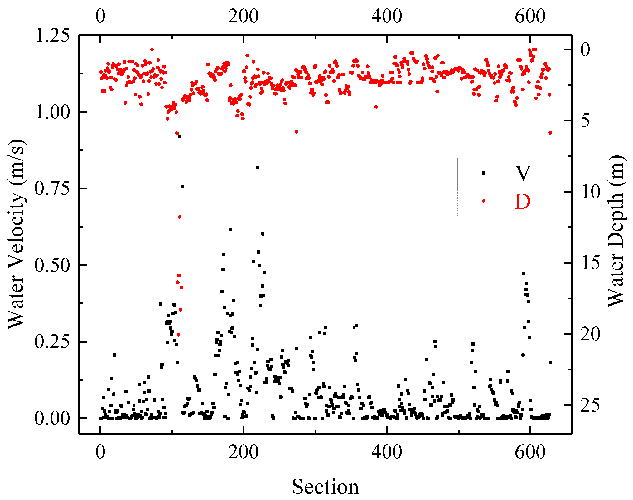
2.3.2. Survey of Key Habitat Factors

The hydrological indicators (depth and velocity), river morphology (substrate) and water quality factors (NH3-N and DO) were selected as the key habitat factors for fish growth and reproduction [40,41], as shown in Table A1 in Appendix A. The river network was segmented according to the key habitat factors and then measured in accordance with the flow state of the river on a free scale. The critical environmental factors that affect the habitat restoration of target fishes were collected, including the abovementioned factors and other indicators, such as the characteristics of the riverbank, discharge, near land use, and botanical data. The habitat demand range for each influencing factor of the target fish species was determined based on expert opinions and historical data, and the factors were distinguished and graded. A field survey plan (Table A2 in Appendix A) for large-scale fish habitats in the plain urban river network was established, which provided data support for the application of fuzzy rules and subsequent model establishment.

2.3.3. Hydrodynamic Model

The river simulation software Infoworks Integrated Catchment Management (ICM, version 7.0) was used for hydrodynamic calculations. The ICM discretizes the Saint-Venant equations based on the Preissman four-point implicit scheme, in which the upstream boundary of the model uses the discharge as the control condition and the downstream boundary uses the water level. The hydrodynamic model for the river network covers a total area of 178 km2, with a total of approximately 120 river stations constructed. All dispatch data during the field observation period were used. After calibration and verification, the simulated results from a one-dimensional hydrodynamic mathematical model in Dianbei was used for subsequent habitat simulation.

2.3.4. Evaluation Model for Fish Habitat Resilience Potential Based on Fish Habitat Suitability

The evaluation model for fish habitat resilience potential in the urban river network plain was based on fish habitat suitability and was divided into two parts: (1) a fish habitat suitability model, and (2) an evaluation model for fish habitat resilience potential. In the model, data on water depth and flow velocity from hydrodynamic modelling results were used, monitoring data on water quality parameters in the major river sections during the water diversion period, and data on riverbank characteristics and riverbed geomorphology from the field survey. The river network was divided into 738 sections to construct a data platform for simulating the potential for fish habitat restoration.
For the fish habitat suitability model (HSM), flow velocity (v), water depth (d) and substrate (sub) were selected as indicators of the habitat in natural rivers less impacted by pollutants. For the fish habitat resilience potential model (HRPM), factors of water quality were extended in HSIM due to their importance in urban rivers in this research. Based on expert knowledge and literature data, fuzzy sets were formulated for three indicator species of different life stages, namely, C. auratus (feeding and spawning period), T. fasciatus adults, and A. japonica adults. Fuzzy sets were defined and described by membership functions. Unlike classical sets with definite boundaries, the boundaries of the membership functions of fuzzy sets usually overlap. The key indicators were classified into three levels: low (L), moderate (M), and high (H). The habitat suitability index (HSI) was classified into five levels: very low (VL), low (L), moderate (M), high (H), and very high (VH). Fuzzy rules have two parts: conditions (IF), and results (THEN). The fuzzy reasoning process adopted the Mamdani method [42] to realize nonlinear mapping from the input factors to the habitat suitability index. The defuzzification process adopted the center of gravity method, which has good tolerance. The HSI that was simulated was characterized by a dimensionless value of 0–1, where 0 represented “very low” suitability and 1 represented “very high” suitability. These values represented the lower and upper thresholds of habitat suitability, respectively. The general steps of the fish habitat suitability model are shown in Figure 2a, and the fuzzy sets and fuzzy rules for C. auratus during the spawning period are shown in Figure 2b.
For the evaluation model of the fish habitat resilience potential, a three-stage calculation method (Figure 2c) was used to construct a habitat resilience potential index (HRPI). The HSI together with two water quality parameters (NH3-N and DO) were selected as the input parameters for the next stage to establish a new round of fuzzy set formulation. Finally, the simulated HRPI was achieved as the model output.
For comparison, the weighted usable area (WUA) was divided by the total plaque area to obtain the dimensionless average habitat resilience potential index (AHRPI) via the following equation, with the retuned values ranging from 0 to 1.
A H R P I = W U A j = 1 N A j
where Aj = the area of unit j, (m2); HSIj = the habitat suitability index of unit j; and N = the number of units.

3. Results

3.1. Habitat Characteristics and Water Quality Changes with Water Diversion

According to the large-scale habitat survey (Figure 3), 72.6% of the river sections had a velocity of level 1, that is, 0~0.1 m/s. Only 1.3% of the river sections were at level 5, with the Huangpu River at over 0.7 m/s. The Caohejing and Puhuitang Rivers flow quickly in the network. For water depth, 2.2% of the river sections ranged from 0 to 0.5 m, and 56.5% ranged from 1.5 to 3 m. The depths of the Suzhou River, Dianpu River, and Huangpu River in the northern, southern and eastern boundaries were greater than 3 m.
Riverbanks were divided into five classes: cement channels, assembled stone, silts, vegetation, and natural vegetation for slope protection. The riparian vegetation was divided into five grades according to the vegetation type and coverage rate (Table A2). Substrates of most of the riverbed were cement channels with small differences in the river network.
The results for DO, CODMn, NH3-N and TP at the eleven sampling sites are shown in Figure 4. The DO concentration at the nine sampling sites was less than 5.0 mg/L, and NH3-N pollution was severe, with all sampling sites exceeding 2.0 mg/L before water diversion. The CODMn concentration at all the sampling sites was greater than 5.0 mg/L. The TP concentration at ten sampling sites before water diversion was greater than 0.2 mg/L. The DO concentration at most of the monitoring sites increased during the period of enhanced water diversion and decreased during the period of routine water diversion. The NH3-N concentration at most of the monitoring sites decreased during the period of enhanced water diversion but did not recover during the period of routine water diversion. Overall, CODMn did not significantly increase or decrease during water diversion. However, TP presented an increasing trend during water diversion.

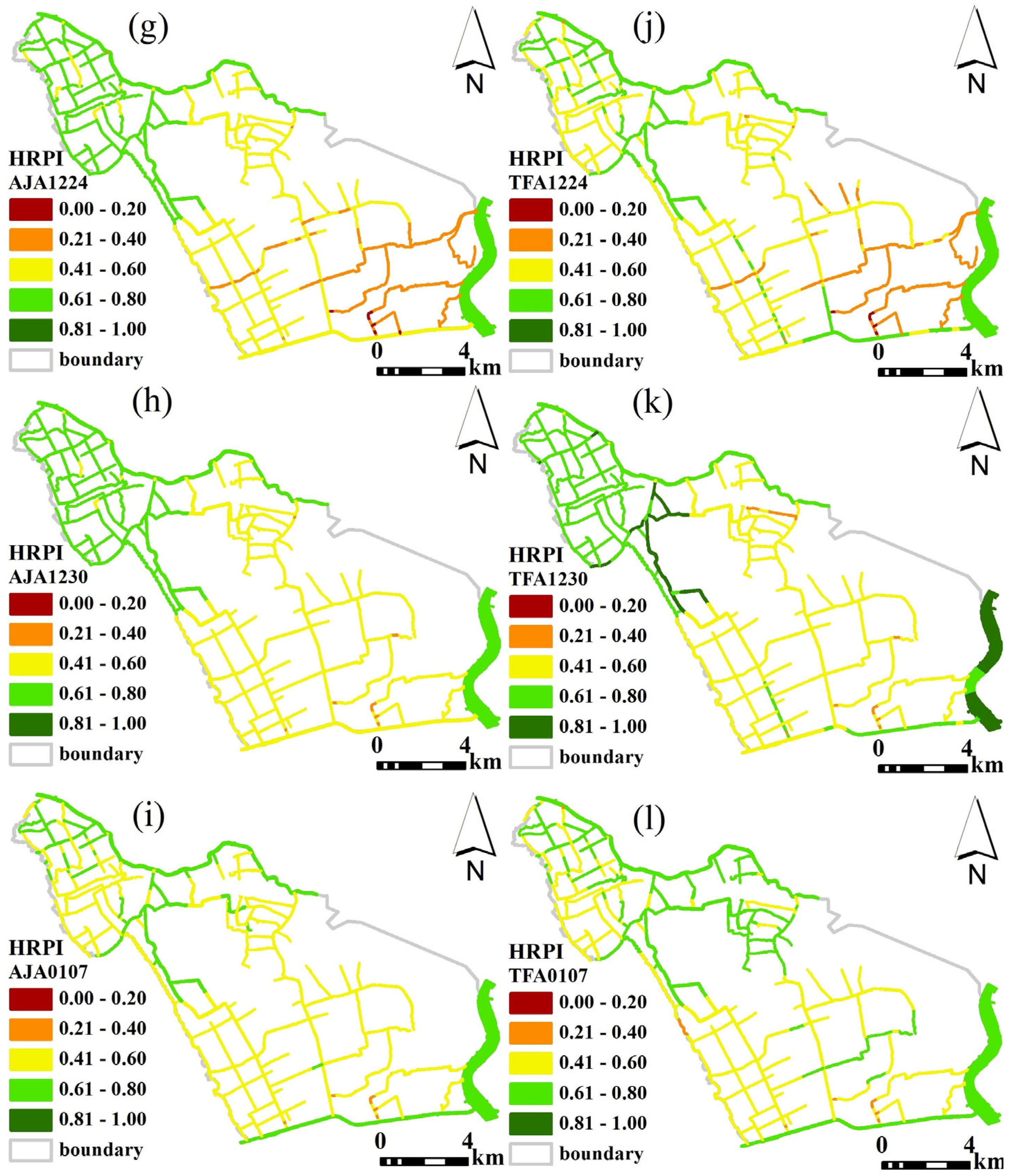
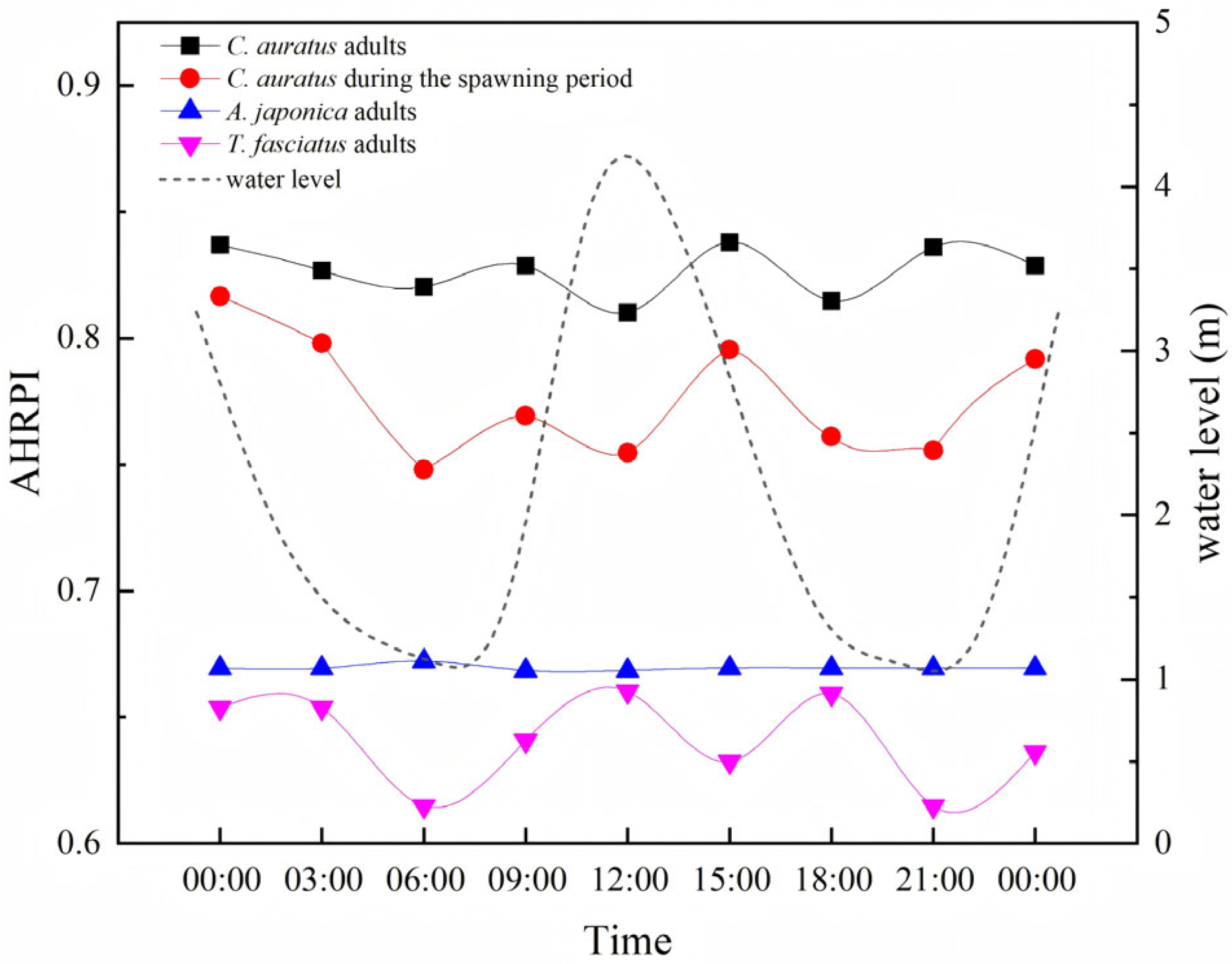
3.2. Fish Habitat Restoration Potential Resilience (HRPI) with Water Diversion

In terms of tolerant fish species, the HRPI was generally high in the Dianbei. For the HRPI of C. auratus adults (Figure 5a–c), approximately 62.8% of the indices were above 0.6 and were concentrated in the northwest area of the river network. Most of the area exhibited moderate resilience potential during the spawning period of C. auratus (Figure 5d–f), with an HRPI between 0.4 and 0.6. The larger rivers in the boundary, e.g., the Suzhou River, Dianpu River, and Huangpu River, presented high levels of HRPI. The HRPI of the two sensitive adult fishes was lower than that of the tolerable species. The resilience potential of A. japonica adults (Figure 5g–i) and T. fasciatus adults (Figure 5j–l) was lower, with only approximately 60% of the river sections exhibiting moderate resilience.
The fish habitat resilience potential improved to different degrees in response to water diversion for C. auratus adults, T. fasciatus adults, and A. japonica adults. The level of HRPI during the period of enhanced water diversion increased greatly, with the number of river sections at high levels increased, and the number of river sections at low levels decreased. An obvious improvement occurred in the southwestern area of the river network. For C. auratus adults, the proportion of river sections at high and very high levels increased from 62.8% to 97.6% (Figure 5a–c). When the hydrodynamic conditions were changed to the case of routine water diversion, the HRPI only slightly decreased compared with the period of enhanced water diversion. However, for C. auratus in the spawning period, the HRPI did not obviously increase with water diversion (Figure 5d–f).
Table 1 summarizes the AHRPI of the target fish species before water diversion, enhanced water diversion, and routine water diversion. With water diversion, the AHRPI increased by 10.3%, 9.3%, and 12.7% for C. auratus adults, T. fasciatus adults and A. japonica adults, respectively, except for that of C. auratus during the spawning period.

4. Discussion

4.1. Feasibility of Improving Fish Habitat Resilience Potential Under Hydrodynamic Regulation

The fish habitat resilience potential could be improved by hydrodynamic regulation. For example, the construction of overflowing dams positively affects fish habitats by improving water quality conditions. However, the natural conditions for fish spawning require a certain velocity and complex flow patterns. River segments with turbulent flow, variable velocity and direction are usually favorable. C. auratus requires a stimulated velocity of approximately 1.1 m/s for spawn, but the average flow rate in the river network is less than 0.6 m/s, which is too low to meet the ecological demand for spawn. Only several river sections, e.g., the Suzhou River and Huangpu River, had higher velocities exceeding 1.1 m/s, with higher habitat resilience potential according to the model calculations (Figure 5).
Tolerant fishes have low hydrological and water quality requirements, and they can survive in environments with high levels of pollution and low levels of dissolved oxygen. Except for the spawning period, their demand for velocity is not rigid. For sensitive fishes, A. japonica has relatively high water and sediment quality requirements, and it is difficult for them to survive in environments with low dissolved oxygen. T. fasciatus has stricter requirements for pollutant concentrations, with high ammonia nitrogen greatly impacting these species, while they are relatively more tolerant to the substrate.
Water diversion can increase the water level and velocity in some river sections, increase the dissolved oxygen concentration, and dilute pollutants such as ammonia, all of which would benefit fish habitat restoration. However, some pollutants, such as CODMn and TP, did not decrease. This is probably caused by the disturbance of sediments during hydrodynamic regulation. If the return of sensitive fishes is expected, further water quality improvement and substrate repair measures could be necessary. In the studied area, most river channels, except several large rivers, cannot meet the ecological needs of C. auratus during the spawning period.
During the period of enhanced water diversion, the sluices on the southern bank of the Dianpu River and the northern bank of the Suzhou River draw water at full capacity twice at the high tides of one day, and the sluices along the western bank of the Huangpu River fully discharge once at the low tide of the night. Hydrodynamic regulation enhanced the water flow of the river network. The flow velocity was greater than 0.05 m/s in 65% of the river sections during the water-drawing stage and in 75% of the rivers during the water-draining stage. The habitat resilience potential of C. auratus adults, A. japonica and T. fasciatus improved during hydrodynamic regulation (Figure 5), particularly in the southeastern area of the river networks, where the resilience potential increased by one level. During the period of routine water diversion, the resilience potential of the three-indicator species subsequently decreased. These data can support the subsequent determination of the threshold of ecological restoration in the Dianbei.
As water flows in the river network change with the tide cycle in the Huangpu River, the fish habitat restoration potential fluctuates with the tidal rhythm. When the water level decreases, the fish habitat resilience potential decreases. When the water level increases, the fish habitat resilience potential increases. Therefore, the suitability of the target fish habitat and the response curve of the hydrodynamic parameters are positively correlated. However, improvements in the resilience potential of fish habitats via hydrodynamic regulation are still limited. Managers could change the water diversion strategy and intensity according to requirements for ecological restoration in different periods, combined with further improvements in the water quality and suitability of the substrate.

4.2. River Habitat Restoration Potential Evaluation Model Feedback

The protection and recovery of endangered species are important for restoring biological diversity. The responses of aquatic species to habitats must be determined [43,44], with hydrological conditions and water quality as two principal aspects of habitat metrics. It is necessary to improve or at least maintain habitats for the restoration of aquatic ecological systems [43]; hence, the environmental factors affecting river systems need to be discerned [45], and suitable indicators must be chosen to evaluate habitat suitability [46]. Previous models have emphasized the prediction of species-level indices more than the selection of the most important habitat factors for restoration [47]. In this research, further simulated scenarios were conducted, in which water quality and hydrodynamics were used as individual control variables (Table 2). Then, simulation results of these two scenarios were compared with the simulation results from the integrated variables of water quality and hydrodynamics. Water quality was found to be the most important contributing factor for the resilience potential of fish habitats. With no change in hydrodynamic conditions, improved water quality obviously increased the habitat resilience potential of the three indicator fishes in the adult stage. For the sensitive adult fish, T. fasciatus, the potential increased by 14.4% on average in the river network. However, adjusting only the hydrodynamic conditions had a poor effect on the habitat resilience of sensitive fish. For C. auratus in the spawning period, which has high hydrodynamic requirements, the integrated regulation of hydrodynamics and water quality can achieve positive results, although it only results in an increase of 0.95%. However, independent regulation of water quality or hydrodynamic conditions results in a negative increase of more than 10%. The area of the river channel is believed to account for these results. The advantage of the increased hydrodynamic force of the slender channel of C. auratus during the spawning period cannot offset the slight decline in hydrodynamic conditions in the main channel. Therefore, water quality is the preferred habitat factor for habitat resilience potential.
The relative importance of hydrodynamic conditions and water quality can also be observed in different areas of the river network. The water quality in the southeastern areas was worse, while the water flow conditions were better. The HRPI of the three indicator fishes in the adult period was not high, but that of C. auratus in the spawning period was greater because hydrological conditions such as velocity and water level were the priority habitat factors for this fish in the spawning stage. For C. auratus adults and the two sensitive adult fishes, hydrological conditions had little effect, whereas water quality was the limiting factor. During water diversion, the DO concentration increased, and the NH3-N concentration decreased in the southeastern area. However, owing to hydrological limitations in this area, the habitat resilience potential of C. auratus during the spawning period has decreased. In terms of the average fish habitat resilience potential changing with tides (Figure 6), the sensitive A. japonica responded poorly to changes in water level. Because A. japonica needs to migrate and desires to inhabit soil holes and stone crevices, better sediment conditions and flow rate stimulation are considered important for their recovery. For T. fasciatus, the connectivity of the river networks was reduced by building dams or water gates, and their migration routes were cut off as a cause of their endangerment.
Innovatively, this research has established the evaluation model for fish habitat resilience potential to explore changes in the eco-health of urban river network. Particularly, the urban river network is featured in crisscrossed rivers with weak flow, hydrodynamic regulation with a great number of sluice gates, and heavy pollution from urbanized areas.
According to the simulation results, hydrodynamic regulation not only needs to consider improvements in hydrodynamic conditions and water quality, it also needs to pay attention to the activities of fish at different stages of the life cycle, which could be crucial for enhancing the potential for habitat restoration. For river management, the connectivity in areas with poor resilience potential can be determined through analysis of the spatial distribution of the resilience potential of fish habitats across the river network. If fishes are unable to complete life activities in some areas, a simulation with local parameter adjustment can be conducted to obtain parameter thresholds, which are fed back to the restoration plan. It is worth noting that this research is limited in the simulation of a short-term improvement in the fish habitat by water diversion, while fish recovery is a long-term process. On this point, the results need to be further verified in future field observation. In addition to this, the ecological flow rate in the river networks could be further calculated to guide the accurate operation of water diversion for the restoration of the fish habitat.
Although the restoration potential of the fish habitat has been improved by water diversion in this research, several important facts for fish habitat restoration have to be emphasized: (1) Water quality is crucial, and great efforts should be made to cleaner water by continuously reducing pollution. (2) Fish migration barriers should be removed for free fish migration. (3) Hydromorphological restoration of rivers that have been altered by man are necessary, aiming for natural rivers where possible with natural banks, meandering, etc.

5. Conclusions

Based on the concept of resilience and theories related to fish habitat suitability, an evaluation model for fish habitat resilience potential was established to explore changes in the eco-health of urban river networks under hydrodynamic regulation. It was demonstrated that the habitat resilience potential of urban river networks can be improved through hydrodynamic improvement. River managers can obtain data to support the restoration of urban river networks by means of water replenishment or other hydrodynamic regulation. The spatial distribution of the fish habitat restoration potential can be used for analysis, the poor parameters can be adjusted, and then the ecological water demand scheduling threshold can be calculated and fed back to the restoration plan. In addition, this model could be applicable to other indicator organisms in other rivers, but different index factors should be selected for different types. Despite the improvement of fish habitats by water diversion in this research, the important facts in the restoration of fish habitats have to be emphasized; for instance, better water quality, removing barriers to free fish migration, and hydromorphological restoration of rivers toward natural rivers where possible.

Author Contributions

Conceptualization, J.Z. and Q.Y.; methodology, J.Z.; validation, Q.Y., T.L. and X.W.; formal analysis, J.Z.; investigation, J.Z. and C.X.; resources, J.Z., C.X. and B.J.; data curation, J.Z. and C.X.; writing—original draft preparation, J.Z. and Q.Y.; writing—review and editing, J.Z., T.L., X.W., B.J., D.S., G.S. and Q.Y.; visualization, J.Z., T.L. and X.W.; supervision, Q.Y.; project administration, J.Z.; funding acquisition, J.Z. All authors have read and agreed to the published version of the manuscript.

Funding

This research was funded by the NSFC-DFG Collaborative Research Program of the National Natural Science Foundation of China (No. 52061135104), the National Natural Science Foundation of China (No. 41807398), and the Science and Technology Support Program for Youth Innovation in Universities of Shandong (2023KJ243).

Data Availability Statement

Data will be made available on request.

Conflicts of Interest

The authors declare that they have no competing financial interests.

Appendix A

Table A1. Key habitat factors for fish habitats.
TypeIndexRange of Study AreaEcological Significance
Hydrologicalvelocity (m/s)0–2 m/sIt can affect the concentration of nutrients in the water body, stimulate the swimming and route of migratory fish, and provide suitable conditions for floating fish eggs to hatch downstream.
depth (m)0–25 mWater depth provides a suitable moving space for bottom-dwelling fish and a hatching environment for sinking eggs.
River morphologysubstraterock or hard channelsOne of the sources of nutrients needed by aquatic animals; the distribution of bottom-dwelling locations and spawning grounds that fish species choose are impacted of substrate styles.
Water qualityDO (mg/L)0.6–8 mg/LBreathing and feeding activities are reduced and, at the same time, immunity, growth, and metabolism activities are affected by hypoxic stress of fish when the DO content in the river is too low. However, bubble disease in fish will be caused by a DO concentration that is too high.
NH3-N (mg/L)0.8–4.5 mg/LFish species poisoning will take place, their respiratory function will be inhibited, and their nerve centers will be damaged, which is manifested by a significant reduction in food intake. Moreover, their immune function will be impaired, various abnormal physiological and biochemical indicators will be shown, and the fish will die.
Table A2. Large-scale field survey plan for fish habitats in the plain urban river network.
Habitat TypeUsed TypeUrbanization LevelDischarge
Stream segment: (Shipping)Very lowVery low
Beginning coordinate: ElectricityLowLow
Ending coordinate:Water supplyLow to moderateLow to moderate
Fishway: ModerateModerate
Yes Moderate to highModerate to high
No Very highVery high
DO (mg/L)CODMn (mg/L)NH3-N (mg/L)TP (mg/L)
≥7.5≤2≤0.15≤0.02
6–7.52–40.15–0.50.02–0.1
5–64–60.5–10.1–0.2
3–56–101–1.50.2–0.3
2–310–151.5–20.3–0.4
<2>15>2>0.4
DepthVelocitySubstrate
0–30 cm0–10 cm/sMucky clay, <0.063 mm
20–50 cm10–30 cm/sSilt, 0.063–2.0 mm
40–70 cm20–50 cm/sSmall gravel, 2.0–6.0 mm
60–120 cm40–70 cm/sModerate gravel, 6.0–20.0 mm
100–200 cm>70 cm/sBig graval, 2.0–6.0 cm
>200 cm Big cobblestone, 12.0–20 cm
Boulder, >20.0 cm
Rock or hard channel

Porosity filling Suspended solids
11
22
33
44
55
Riparian vegetation:Riverbank type:
Coverage rates are higher than 80% and more than 5 plant types Cement channel
The planting coverage rate is between 60~80%, and there are 4 or 5 plant types Stone assembled
The planting coverage rate is between 40~60%, and there are 3 or 4 plant types Vegetation
The planting coverage rate is between 20~40%, and there are 2 or 3 plant types Nature
The penetration rate is less than 20% and there was only a uniform plant type Mucky clay

References

  1. Dong, Z.R. River Restoration; China Water & Power Press: Beijing, China, 2003. [Google Scholar]
  2. Song, Q.; Yang, Z. Thinking of integrated management of urban rivers in China. Adv. Water Sci. 2002, 13, 377–382. (In Chinese) [Google Scholar]
  3. Yang, S.H. Urban Ecological Environment; Science Press: Beijing, China, 2003. [Google Scholar]
  4. Dynesius, M.; Nilsson, C. Fragmentation and flow regulation of river systems in the Northern Third of the World. Science 1994, 266, 753–762. [Google Scholar] [CrossRef] [PubMed]
  5. Maddock, I. The importance of physical habitat assessment for evaluating river health. Freshw. Biol. 2010, 41, 373–391. [Google Scholar] [CrossRef]
  6. Fang, Y.P.; Wang, M.J.; Deng, W.; Xu, K.Y. Exploitation scale of hydropower based on instream flow requirements: A case from southwest China. Renew. Sustain. Energy Rev. 2010, 14, 2290–2297. [Google Scholar] [CrossRef]
  7. Luo, Z.; Zuo, Q.; Shao, Q. A new framework for assessing river ecosystem health with consideration of human service demand. Sci. Total Environ. 2018, 640–641, 442–453. [Google Scholar] [CrossRef]
  8. Guan, Y.Q.; Chen, Y.; Zhang, D.R.; Du, X.X.; Tian, X.Z.; Chen, Y.Z. Aquatic environmental simulation and pollutant load calculation in plain river networks. Water Resour. Prot. 2016, 32, 111–118. (In Chinese) [Google Scholar]
  9. Song, S.; Xu, Y.P.; Zhang, J.X.; Li, G.; Wang, Y.F. The long-term water level dynamics during urbanization in plain catchment in Yangtze River Delta. Agric. Water Manag. 2016, 174, 93–102. [Google Scholar] [CrossRef]
  10. Pan, H.Z.; Li, Y.P.; Tang, C.Y.; Acharya, K.; Yao, X.Y.; Zhang, J.; Zhu, Y.; Chen, Y.X.; Chen, Y.; Yu, S. Evaluation of the effect of water diversion on improving water environment in plain river network under the multi-objective optimization. J. Lake Sci. 2021, 33, 15. (In Chinese) [Google Scholar]
  11. Yan, Y.; Yuan, S.Y.; Tang, H.W.; Lyu, S.Q.; Lei, Y.; Li, Y. Hydrodynamic reconstruction of wennan river network in Shanghai city. J. Hohai Univ. (Nat. Sci.) 2021, 49, 329–334+365. (In Chinese) [Google Scholar]
  12. Zeng, Y.S.; Bi, C.J.; Jia, J.P.; Deng, L.; Chen, Z.L. Impact of intensive land use on heavy metal concentrations and ecological risks in an urbanized river network of Shanghai. Ecol. Indic. 2020, 116, 106501. [Google Scholar] [CrossRef]
  13. Bernhardt, E.S.; Palmer, M.A.; Allan, J.D.; Alexander, G.; Barnas, K.; Brooks, S. Synthesizing, U.S. River Restoration Efforts. Science 2005, 308, 636–637. [Google Scholar] [CrossRef] [PubMed]
  14. Grill, G.; Lehner, B.; Thieme, M.; Geenen, B.; Tickner, D.; Antonelli, F.; Babu, S.; Borrelli, P.; Cheng, L.; Crochetiere, H.; et al. Mapping the world’s free-flowing rivers. Nature 2019, 569, 215–221. [Google Scholar] [CrossRef]
  15. Deng, X. Correlations between water quality and the structure and connectivity of the river network in the Southern Jiangsu Plain, Eastern China. Sci. Total Environ. 2019, 664, 583–594. [Google Scholar] [CrossRef] [PubMed]
  16. Cui, G.B.; Chen, X.; Xiang, L.; Zhang, Q.C.; Xu, Q. Evaluation of water environment improvement by interconnected river network in plain area. J. Hydraul. Eng. 2017, 48, 1429–1437. (In Chinese) [Google Scholar]
  17. Deng, X.J. Influence of water body area on water quality in the southern Jiangsu Plain, eastern China. J. Clean. Prod. 2020, 254, 120136. [Google Scholar] [CrossRef]
  18. Wang, T.; Wang, J.; Lei, Q.; Zhao, Y.; Wang, L.; Wang, X.; Zhang, W. Microplastic pollution in sophisticated urban river systems: Combined influence of land-use types and physicochemical characteristics. Environ. Pollut. 2021, 287, 117604. [Google Scholar] [CrossRef]
  19. Yin, H.; Islam, M.S.; Ju, M. Urban river pollution in the densely populated city of Dhaka, Bangladesh: Big picture and rehabilitation experience from other developing countries. J. Clean. Prod. 2021, 321, 129040. [Google Scholar] [CrossRef]
  20. McKinney, M.L. Effects of urbanization on species richness: A review of plants and animals. Urban Ecosyst. 2008, 11, 161–176. [Google Scholar] [CrossRef]
  21. Mulholland, P.J.; Houser, J.N.; Maloney, K.O. Stream diurnal dissolved oxygen profiles as indicators of in-stream metabolism and disturbance effects: Fort Benning as a case study. Ecol. Indic. 2005, 5, 243–252. [Google Scholar] [CrossRef]
  22. Lu, X.C.; Li, Y.P.; Huang, D.J.; Zhou, D.; He, M.J.; Jiang, W.B. Study on water diversion schemes for improvement of hydrodynamics in plain river network. Water Resour. Power 2015, 33, 93–95+138. (In Chinese) [Google Scholar]
  23. Hwang, J.Y.; Kim, Y.D.; Kwon, J.H.; Park, J.H.; Noh, J.W.; Yi, Y.K. Hydrodynamic and water quality modeling for gate operation: A case study for the Seonakdong River basin in Korea. KSCE J. Civ. Eng. 2013, 18, 73–80. [Google Scholar] [CrossRef]
  24. Gallardo, B.; Aldridge, D.C. Inter-basin water transfers and the expansion of aquatic invasive species. Water Res. 2018, 143, 282–291. [Google Scholar] [CrossRef] [PubMed]
  25. Li, Y.P.; Acharya, K.; Yu, Z.B. Modeling impacts of Yangtze River water transfer on water ages in Lake Taihu, China. Ecol. Eng. 2011, 37, 325–334. [Google Scholar] [CrossRef]
  26. Du, J.; Chen, H.H.; Chen, Z.H.; Chen, D.W. Water diversion and control for water environment in tidal network of Pearl river delta. J. China Hydrol. 2012, 32, 16–21. (In Chinese) [Google Scholar]
  27. Xia, K.; Wang, H.; Qin, W.H.; Qian, J. Assessment on effects of water quality improvement in inner Qinhuai River by water dispatching. Water Resour. Prot. 2015, 31, 74–78+110. (In Chinese) [Google Scholar]
  28. Yu, S.; Li, Y.P.; Cheng, Y.X.; Shi, Y.Y.; Cheng, Y.; Huang, Y.N.; Zhu, Y.; Pan, H.Z.; Yue, Z.W.; Zheng, K. The impacts of water diversion on hydrodynamic regulation of plain river network. J. Lake Sci. 2021, 33, 462–473. (In Chinese) [Google Scholar]
  29. Liu, Z.Q.; Wang, H.; Feng, X.Y.; Yan, H.Y.; Xia, K. Values of plain river network hydraulic regulatory threshold based on water quality objectives. Environ. Sci. Technol. 2021, 44, 200–210. (In Chinese) [Google Scholar]
  30. Tan, P.Y. The Study on Real-Time Optimization of Water Diversion Project Scheme in Lowland River Based on the Varation of Dissolved Ocugen. Ph.D. Thesis, Zhejiang University, Hangzhou, China, 2020. (In Chinese). [Google Scholar]
  31. Zuo, Q.; Chen, H.; Dou, M.; Zhang, Y.; Li, D. Experimental analysis of the impact of sluice regulation on water quality in the highly polluted Huai River Basin, China. Environ. Monit. Assess. 2015, 187, 450. [Google Scholar] [CrossRef]
  32. Zhang, Q.; Chen, Y.D.; Jiang, T.; Chen, X.; Liu, Z. Human-induced regulations of river channels and implications for hydrological alterations in the Pearl River Delta, China. Stoch. Environ. Res. Risk Assess. 2011, 25, 1001–1011. [Google Scholar] [CrossRef]
  33. Tena, A.; Vericat, D.; Gonzalo, L.E.; Batalla, R.J. Spatial and temporal dynamics of macrophyte cover in a large regulated river. J. Environ. Manag. 2017, 202, 379–391. [Google Scholar] [CrossRef]
  34. Baruah, A.; Sarma, A.K.; Hinge, G. Hydrological–Hydrodynamic Nexus for Evaluation of Fish Habitat Suitability in the Bhogdoi River, India. J. Hydrol. Eng. 2021, 26, 04021032. [Google Scholar] [CrossRef]
  35. Lavelle, A.M.; Chadwick, M.A.; Chadwick, D.D.A.; Pritchard, E.G.; Bury, N.R. Effects of Habitat Restoration on Fish Communities in Urban Streams. Water 2021, 13, 2170. [Google Scholar] [CrossRef]
  36. Holling, S.C. Resilience and Stability of Ecological Systems. Annu. Rev. Ecol. Syst. 1973, 4, 1–23. [Google Scholar] [CrossRef]
  37. Fuller, I.C.; Gilvear, D.J.; Thoms, M.C.; Death, R.G. Framing resilience for river geomorphology: Reinventing the wheel? River Res. Appl. 2019, 35, 91–106. [Google Scholar] [CrossRef]
  38. Qi, M.; Feng, M.L.; Sun, T.; Yang, W. Resilience changes in watershed systems: A new perspective to quantify long-term hydrological shifts under perturbations. J. Hydrol. 2016, 539, 281–289. [Google Scholar] [CrossRef]
  39. Bouska, K.L.; Houser, J.N.; De Jager, N.R.; Van Appledorn, M.; Rogala, J.T. Applying concepts of general resilience to large river ecosystems: A case study from the Upper Mississippi and Illinois rivers. Ecol. Indic. 2019, 101, 1094–1110. [Google Scholar] [CrossRef]
  40. Fausch, K.D.; Torgersen, C.E.; Baxter, C.V.; Li, H.W. Landscapes to Riverscapes: Bridging the Gap between Research and Conservation of Stream Fishes. BioScience 2002, 52, 483–498. [Google Scholar] [CrossRef]
  41. Marchetti, M.P. Ecology of North American freshwater fishes. Freshw. Sci. 2014, 33, 374–375. [Google Scholar] [CrossRef]
  42. Mamdani, E.H. Application of fuzzy algorithms for control of simple dynamic plant. Proc. Inst. Electr. Eng. 1974, 121, 1585–1588. [Google Scholar] [CrossRef]
  43. Bellmore, J.R.; Baxter, C.V.; Ray, A.M.; Denny, L.; Tardy, K.; Galloway, E. Assessing the potential for salmon recovery via floodplain restoration: A multitrophic level comparison of dredge-mined to reference segments. Environ. Manag. 2012, 49, 734–750. [Google Scholar] [CrossRef]
  44. Whitley, S.N.; Bollens, S.M. Fish assemblages across a vegetation gradient in a restoring tidal freshwater wetland: Diets and potential for resource competition. Environ. Biol. Fishes 2013, 97, 659–674. [Google Scholar] [CrossRef]
  45. Zaky, M.M.M.; Salem, M.A.M.; Persson, K.M.M.; Eslamian, S.S. Incidence of Aeromonas species isolated from water and fish sources of Lake Manzala in Egypt. Int. J. Hydrol. Sci. Technol. 2011, 1, 47–62. [Google Scholar] [CrossRef]
  46. Hughes, S.J.; Santos, J.; Ferreira, T.; Mendes, A. Evaluating the response of biological assemblages as potential indicators for restoration measures in an intermittent Mediterranean river. Environ. Manag. 2010, 46, 285–301. [Google Scholar] [CrossRef] [PubMed]
  47. Zhao, C.S.; Yang, S.T.; Xiang, H.; Liu, C.M.; Zhang, H.T.; Yang, Z.L.; Zhang, Y.; Sun, Y.; Mitrovic, S.M.; Yu, Q.; et al. Hydrologic and water-quality rehabilitation of environments for suitable fish habitat. J. Hydrol. 2015, 530, 799–814. [Google Scholar] [CrossRef]
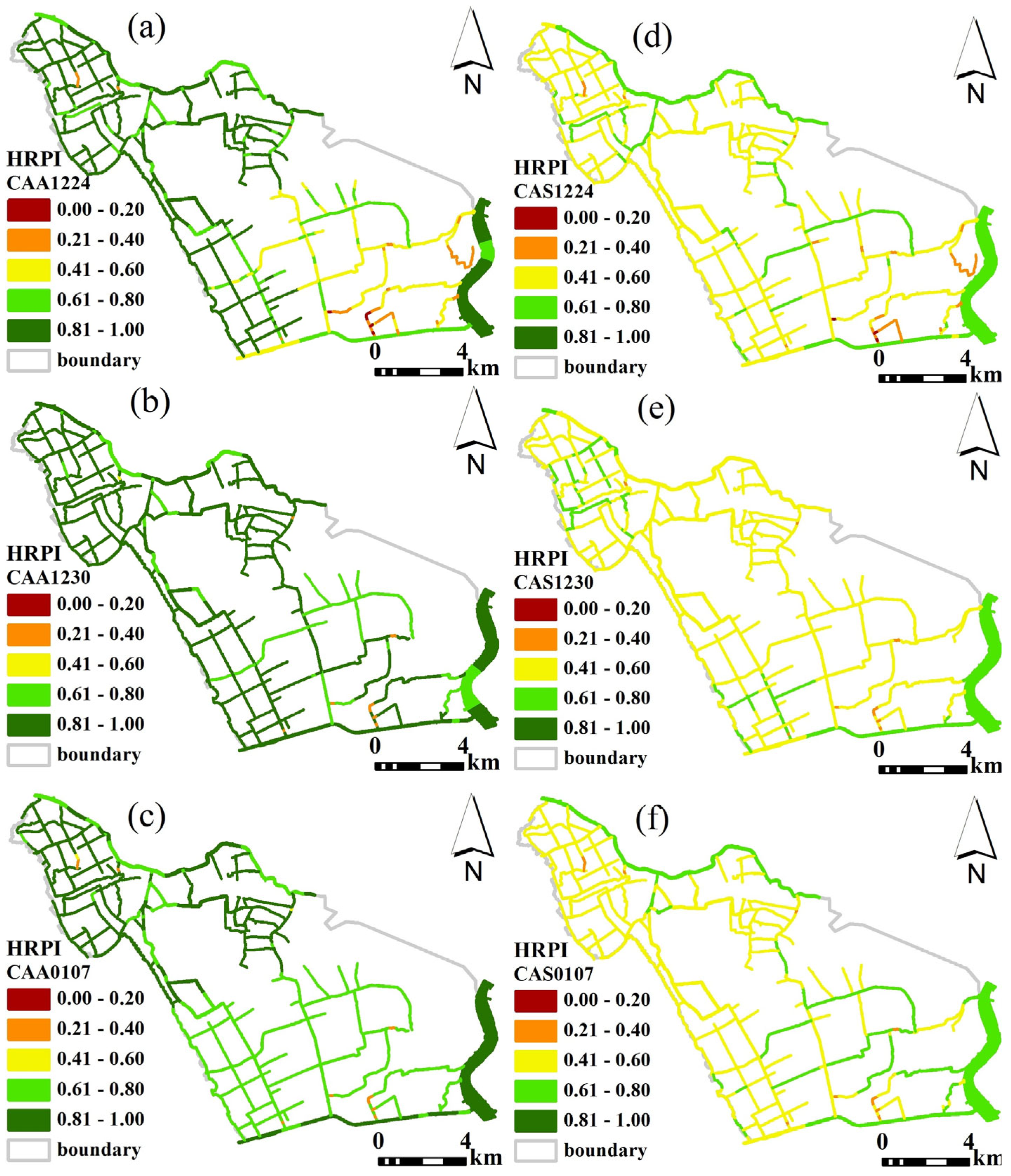
Figure 1. Study area, distribution of monitoring sites for water level, water velocity and water quality (a), one of typical scenes for the river sections (b) and water diversion campaigns (c) in the Dianbei part of Shanghai, China.
Water 17 00817 g001
Figure 2. Components of the evaluation model of fish habitat resilience potential in the river plain network. (a) Major steps to establish a fish habitat suitability model. Some factors, such as water depth, velocity and substrate, are obtained from river systems. (b) A three-stage calculation method. (c) Fuzzy set and fuzzy rules (taking the spawning period of C. auratus as an example).
Water 17 00817 g002
Figure 3. Scatter plot of the water velocity and water depth in the Dianbei. The red points represent the water depth, and the black points represent the water velocity.
Water 17 00817 g003
Figure 4. Comparison of water quality, including DO (a), NH3-N (b), CODMn (c) and TP (d) before water diversion (black bars), during enhanced water (red bars) diversion, and during routine water diversion (yellow bars).
Water 17 00817 g004
Figure 5. Spatial distribution map of the habitat resilience potential index (HRPI) before water diversion (20151224), enhanced water diversion (20151230), and routine water diversion (20160107). HRPI in panels (ac) are for C. auratus adults (CAA); HRPI in panels (df) are for C. auratus during the spawning period (CAS); HRPI in panels (gi) are for A. japonica adults (AJA); and HRPI in panels (jl) are for T. fasciatus adults (TFA).
Water 17 00817 g005aWater 17 00817 g005b
Figure 6. Change of average habitat resilience potential indices (AHRPI) for different fish species with tidal rhythms.
Water 17 00817 g006
Table 1. AHRPI of three target fish species in three phases.
DateCAACASAJATFA
24 December 20150.67590.53890.51720.5269
30 December 20150.77090.52210.55050.5645
7 January 20160.74550.54400.56500.5938
Notes: CAA indicates C. auratus adults, CAS indicates C. auratus in the spawning period, AJA indicates A. japonica adults (AJA), and TFA indicates T. fasciatus adults.
Table 2. AHRPI of three target fish species with hydrodynamic factors and water quality as individual control variables.
Hydrodynamic Factors as the Control VariableWater Quality as the Control Variable
CAACASAJATFACAACASAJATFA
24 December 20150.67590.53890.51720.52690.67590.53890.51720.5269
30 December 20150.76100.47270.54940.56780.71540.44890.51900.5113
7 January 20160.74160.43460.56730.60300.71420.48330.51440.5171
Notes: CAA indicates C. auratus adults, CAS indicates C. auratus in the spawning period, AJA indicates A. japonica adults (AJA), and TFA indicates T. fasciatus adults.
Disclaimer/Publisher’s Note: The statements, opinions and data contained in all publications are solely those of the individual author(s) and contributor(s) and not of MDPI and/or the editor(s). MDPI and/or the editor(s) disclaim responsibility for any injury to people or property resulting from any ideas, methods, instructions or products referred to in the content.

