Article

Regional Circulation and Fate of Typical Antibiotic Discharges in the Yangtze River Estuarine Region

1
South China Sea Marine Forecast and Hazard Mitigation Center, Ministry of Natural Resources, Guangzhou 510300, China
2
First Institute of Oceanography, Ministry of Natural Resources, Qingdao 266061, China
3
Laboratory for Regional Oceanography and Numerical Modeling, Qingdao Marine Science and Technology Center, Qingdao 266071, China
4
Shandong Key Laboratory of Marine Science and Numerical Modeling, Qingdao 266061, China
5
Department of Ocean Science and Engineering, Southern University of Science and Technology, Shenzhen 518055, China
*
Author to whom correspondence should be addressed.
Water 2025, 17(23), 3384; https://doi.org/10.3390/w17233384
Submission received: 30 October 2025 / Revised: 24 November 2025 / Accepted: 25 November 2025 / Published: 27 November 2025
(This article belongs to the Section Oceans and Coastal Zones)

Abstract

The discharge of antibiotics from riverine sources into estuaries and adjacent coastal seas is an emerging environmental concern. In this study, we employ seasonal averages derived from a five-year, high-resolution, three-dimensional ocean circulation model to investigate the transport and degradation of a representative antibiotic tracer with a half-life of 31 days, released from the Yangtze River and the Qiantang River into the East China Sea. The model incorporates realistic tides, climatological winds, and seasonal runoff, enabling an examination of typical seasonal conditions. The simulated tracer remains concentrated near the estuarine outlets, with dispersion shaped by the seasonal circulation and stratification. Particle-tracking experiments show distinct pathways: Yangtze-sourced material is rapidly exported southward along the 30 m isobath, traveling about 100 km within 5–10 days, while Qiantang-sourced material exhibits much longer residence times (>30 days) within Hangzhou Bay. Vertical distributions also vary seasonally, with summer stratification confining the tracer to the surface layer and winter mixing dispersing it to deeper waters offshore. These results highlight the contrasting transport behaviors of the two river sources and illustrate how hydrodynamic conditions regulate antibiotic fate in estuarine–coastal environments.

1. Introduction

Estuarine and coastal ecosystems are dynamic interfaces where complex hydrodynamic processes ranging from river discharge and tidal mixing to seasonal wind-forcing and sub-mesoscale instabilities govern the transport, dispersion, and persistence of contaminants [1]. Understanding these physical mechanisms is essential for predicting the fate of emerging pollutants such as antibiotics, whose environmental persistence and ecological risks have raised growing global concern [2,3].
Antibiotics originating from medical, agricultural, and aquaculture activities frequently enter aquatic systems through wastewater discharge, runoff, and riverine inputs. In the Yangtze River Estuary (YRE), numerous studies have documented widespread antibiotic contamination in surface waters and sediments, with seasonal variations and links to urban and aquaculture sources [4,5]. These compounds can impose selective pressure even at trace levels, promoting the development and spread of resistant pathogens [6]. Long-term observations further show increasing antibiotic resistance genes (ARGs) in estuarine sediments [7], and specific compounds such as sulfamethoxazole and sulfapyridine have been associated with moderate ecological risks to crustaceans [4,8]. Given the YRE’s importance as a major fisheries and water-supply corridor, such contamination raises concerns for both ecosystem integrity and public health [9,10,11,12].
Despite mounting awareness of antibiotic pollution in the YRE, gaps remain in our mechanistic understanding. Several prior studies have focused on occurrence and risk assessment. Yan et al. [4] and Guo et al. [5] characterized the occurrence, distribution, and ecological risks of antibiotics in the YRE’s surface waters and sediments, while Hu et al. [13] and Liu et al. [14] extended the analysis to basin-scale drivers and source attribution across China’s major rivers [13,14]. Several studies used multimedia fugacity models to simulate fate across compartments [15,16]. However, very few have examined how fine-scale estuarine circulation, stratification, and mixing interact with antibiotic decay timescales to shape the fate of dissolved contaminants. Existing observational and modeling studies largely focus on hydrodynamic structures, plume behavior, or measured antibiotic concentrations, but rarely couple three-dimensional physical processes with first-order chemical degradation mechanisms. The complex nature between hydrodynamics and contaminant fate in the YRE remains underexplored.
Furthermore, large-scale assessments have provided invaluable emission inventories and spatial distributions of antibiotics across the Yangtze Basin, yet they often lack the spatiotemporal resolution and process-based modeling needed to link surface inputs to transport pathways and vertical distribution in the estuarine and coastal environment.
Therefore, the principal innovation of this study is the application of a high-resolution, process-based hydrodynamic model to provide a mechanistic understanding of contaminant fate, bridging the gap between physical oceanography and contaminant transport analysis. Unlike previous studies focused on occurrence or multimedia fate models lacking fine-scale hydrodynamic detail [4,5,13,14,15,16], our approach explicitly resolves the seasonal currents and stratification regimes. This provides direct, actionable insights for researchers and decision-makers. For researchers, it offers a physical framework to explain observed concentration patterns. For decision-makers, it identifies specific, dynamic areas of persistent tracer retention: (1) a rapid, far-field export pathway for Yangtze-sourced material along the 30 m isobath, and (2) a chronic, localized accumulation hotspot for Qiantang-sourced material within Hangzhou Bay. This ‘dual risk’ landscape necessitates the targeted monitoring and differentiated management strategies that this study helps to inform.

2. Materials and Methods

2.1. Study Domain

The model domain encompasses the Yangtze River Estuary and the surrounding East China Sea shelf, including Hangzhou Bay to the south. This area features a complex coastline with many islands and branching tidal channels. The bathymetry is shallow (<20 m) within the estuary and bay, deepening to about 50 m at the shelf and further offshore [2]. The Yangtze Estuary splits into multiple outlets around Chongming Island before debouching into the sea, whereas Hangzhou Bay is a funnel-shaped bay with a narrow mouth connecting to the shelf. The region’s hydrodynamics are influenced by tides, monsoon winds, and river discharge. Tides are semidiurnal and large in range. Monsoonal winds blow from the southeast in summer and from the northwest in winter, driving seasonally reversing coastal currents. In summer, the prevailing winds and buoyancy forcing create a northward/northeastward coastal flow (often termed the Changjiang Diluted Water current) along the Chinese coast. In winter, cold northerly winds help generate a southward coastal current (the Zhejiang-Fujian Coastal Current) that carries low-salinity water south toward the Taiwan Strait. The Yangtze River exhibits strong monsoonal seasonality, with monthly mean discharge ranging from approximately 10,000–20,000 m3 s−1 in winter (January–February) to 40,000–50,000 m3 s−1 in summer (July–August), averaging about 30,000 m3 s−1 annually. The Qiantang River, roughly an order of magnitude smaller, varies from <500 m3 s−1 in winter to 1500–2000 m3 s−1 in summer. These factors together produce a dynamic environment where stratification and circulation patterns differ markedly between seasons.

2.2. Model

We used the Regional Ocean Modeling System (ROMS) configured at high resolution (~1 km grid spacing in the estuary and bay) to resolve the fine-scale circulation features. The model has 50 vertical layers on a terrain-following coordinate, allowing representation of stratification in the plume region. Bathymetric data were compiled from nautical charts and ETOPO1 (1-arcminute global relief) for the shelf. The model uses a baroclinic time step of Δt = 10 s. Bottom stress is represented with the log-layer bottom-friction scheme (UV_LOGDRAG), where the drag coefficient is computed from the logarithmic velocity profile using a prescribed roughness length (z0 = 0.02 m) and the height of the first velocity grid point above the bed. This method produces a spatially varying drag coefficient of order 10−3–10−2, which is appropriate for the energetic and shallow environment of the Changjiang Estuary. The model domain spans the entire Yangtze River estuary (29.5° N–32° N, 120° E–124° E, Figure 1a), and is two-way nested from the climatological simulation of China’s marginal seas described by Sun et al. [17], which has been well-validated against various observational datasets. The simulation incorporates 16 tidal constituents and uses 6-hourly climatological atmospheric forcing from the European Centre for Medium-Range Weather Forecasts (ECMWF) operational model analysis as surface boundary conditions. The monthly climatological mean discharges of the Yangtze River and Qiantang River are incorporated into the model. The atmospheric forcing and river discharges are based on multi-year climatological means. Therefore, the simulation represents a typical mean year and does not capture episodic events, such as storm-driven mixing or short-term pollution pulses. The model was run for a 20-year spin-up period to eliminate initial transients and allow both barotropic and baroclinic components of circulation, stratification, and the bottom boundary layer to reach a stable quasi-equilibrium under strong tidal forcing and substantial river discharge. The chosen duration ensures dynamic consistency before introducing the tracer simulations. The results presented are the seasonal averages computed from the final 5 years of this equilibrated simulation, which represent the stable, repeating seasonal patterns of the system. Sulfamethazine was selected as a representative antibiotic tracer because it is a commonly detected and moderately persistent sulfonamide in Chinese riverine and estuarine environments. Following Chen et al. and Li et al., who reported degradation half-lives of approximately 25–35 days at 20 °C for sulfonamide antibiotics in aquatic systems, we adopted a representative half-life of 31 days for the modeled tracer [18,19]. The tracer was released continuously from the two river sources throughout the simulation. The concentration is configured to undergo first-order decay to mimic natural temperature-dependent decomposition processes computed from:
C   = C 0   ×   e ln 2 λ   ×   K T 25 10   ×   t
where C 0 represents the concentration advected be the ocean current, and T denotes the water temperature, and λ represents the half-life, and t represents the elapsed time for the decay calculation [20,21]. We applied a temperature-dependent coefficient of K = 2.2 to the base decay rate (roughly doubling the decay rate for every 10 °C increase in water temperature), mimicking natural biodegradation processes. The simulated antibiotic tracer is represented as a dimensionless, normalized concentration field, because the governing transport equations are linear with respect to concentration. In addition, the modeled concentrations should be interpreted as relative hydrodynamic transport patterns, not as absolute environmental pollution levels. No explicit photolysis term was included beyond the implicit effects of temperature, which may cause us to underestimate decay in sunlit surface waters for photo-labile compounds [22,23]. In our simulation, the tracer remains in the dissolved phase; we do not account for adsorption to sediments or deposition to the seabed. While sorption can be significant for some antibiotics [24], neglecting sediment sinks in this first-order model means our results may slightly overestimate water-column persistence for strongly sorbing compounds.
Additionally, mean pathways and transit time was estimated by keeping tracking of passive particles released from the Yangtze River and Qiantang River, as a measure of preferred trajectories and spatially how quickly pollutants can be flushed out. Passive particle trajectories were integrated based on the 3-D ROMS-simulated velocity fields using the Connectivity Modeling System (CMS) [25]. The code advects marked parcels on a nested grid while sampling sub-grid turbulent dispersion, yielding high-resolution trajectories that resolve estuarine-to-coastal-scale transport. This framework has been used to simulate transit and residence time [26,27], exchange of biogeochemical particles at local [28], regional and inter-basin scales. Although we lacked observational concentration data for antibiotics to directly validate the tracer results, we compared model-predicted salinity and currents against available data (historical salinity profiles, tidal gauge records, drifter trajectories from literature) to ensure the physical transport processes were realistic [17]. The model reproduced known features such as the extent of the Yangtze Diluted Water plume (low-salinity water extending northeast toward the Yellow Sea in summer) and the strong mixing and turbidity in Hangzhou Bay in winter, giving confidence in the use of the model for tracer predictions.
We acknowledge that sediment adsorption, particle-bound transport, photolysis and transformation processes are not explicitly resolved in this tracer modeling. Instead, we treat the antibiotic tracer as dissolved and subject to a bulk first-order decay. This simplification reflects our focus on hydrodynamic transport in the estuarine/coastal domain, and the limited availability of consistent sediment/adsorption and photolysis data for SMZ under marine conditions. As research shows [29,30,31], these additional sinks may be relevant, and future work should integrate them.

2.3. Density Ratio Calculation

To quantify the relative contributions of temperature and salinity to density stratification, we computed the density ratio following the standard oceanographic definition:
R ρ   = β S / z α T / z ,
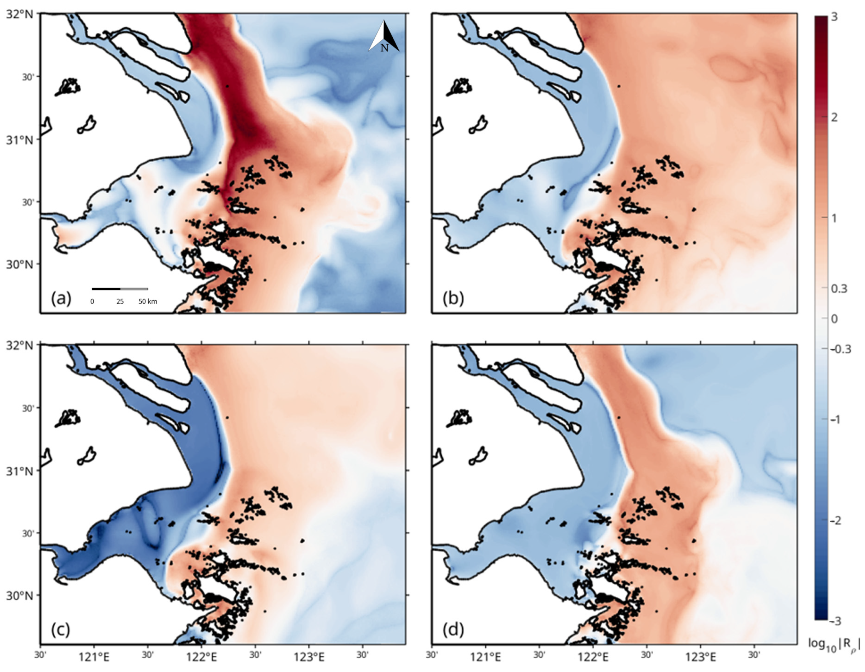
where α is the thermal expansion coefficient, S represents salinity, and T represents potential temperature, and z represents the vertical coordinate (depth) and β is the haline contraction coefficient [32]. Vertical gradients of temperature ( T / z ) and salinity ( S / z ) were calculated from the model outputs at each grid point. The ratio R ρ distinguishes whether salinity or temperature predominantly controls water density stratification: values near 1 indicate that temperature and salinity effects are approximately balanced (their contributions compensate each other) [33], whereas ( R ρ > 2~log10| R ρ | > 0.3) and ( R ρ < 1/2~log10| R ρ | < −0.3) represent salinity-dominated (haline) and temperature-dominated (thermal) regimes, respectively. The logarithm of R ρ was used for visualization to emphasize the spatial contrast between the two regimes.

3. Results and Analysis

3.1. Seasonal Circulation and Density Structure of the East China Sea

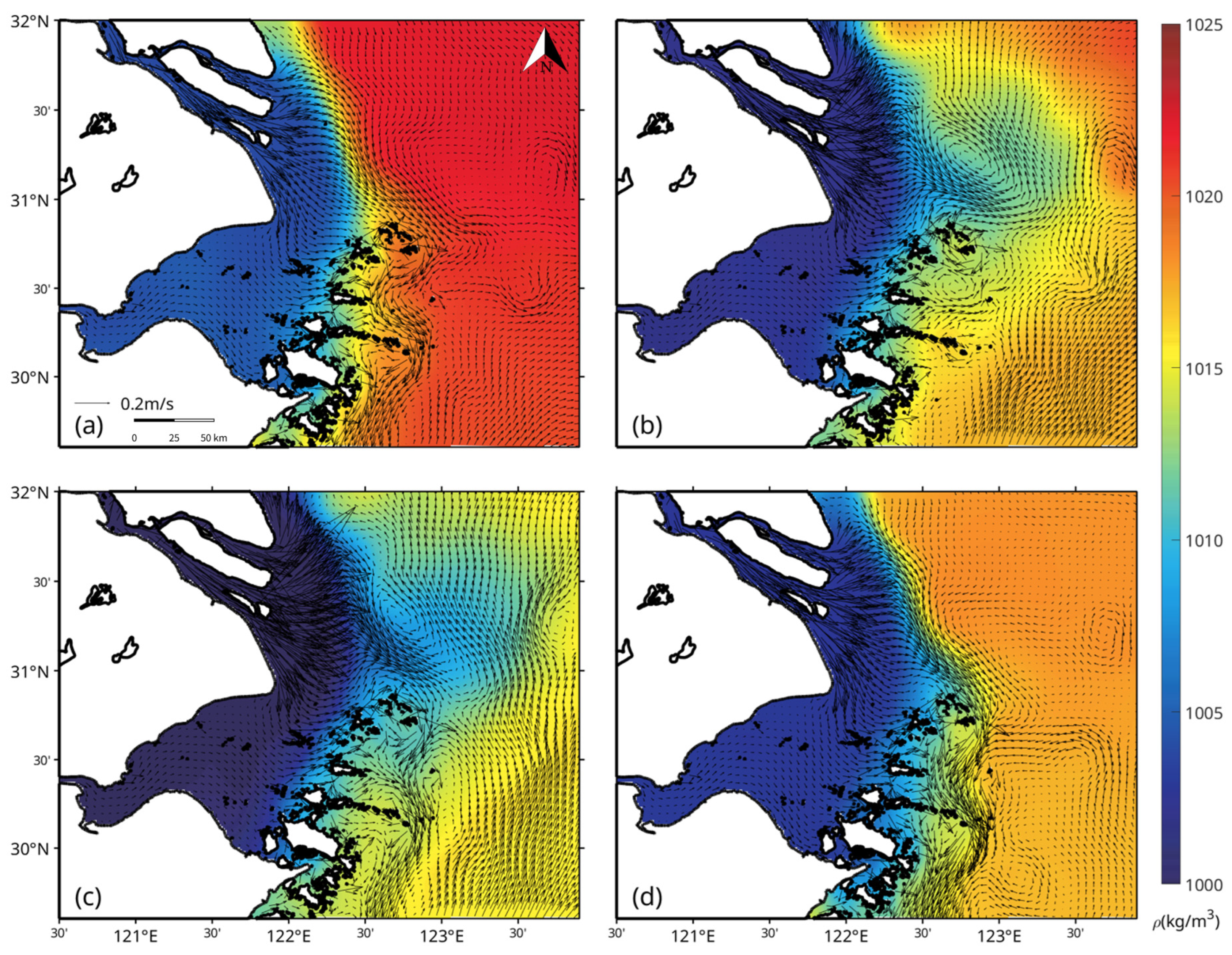
The model simulations reveal strong seasonal variability in the circulation and density field of the East China Sea (ECS) (Figure 2). In winter, vertically averaged currents show a pronounced southward coastal flow originating from the Yangtze River estuary and the Hangzhou Bay region. This corresponds to the Zhejiang-Fujian coastal current, which carries buoyant freshwater southward along the coast under the prevailing northerly monsoon wind [34,35,36]. The coastal current is accompanied by a sharp horizontal density gradient, with low-density water from river discharge near the coast, while higher-density offshore water lies seaward (Figure 2a). This pattern is consistent with observations that in winter the Yangtze River plume remains confined to the inner shelf and extends southward, creating a band of diluted water along the coast [34,37]. Offshore, the influence of the Kuroshio is evident as denser, saline water flowing northeastward along the shelf break, contributing to the strong cross-shelf density contrast in winter (Figure 2a).
By contrast, in summer (Figure 2c) the river plume shifts northward and eastward: vertically averaged currents near the Yangtze River estuary turn east-northeast, spreading freshened water across the mid-shelf. The low-density water covers a much broader area off the estuary in summer (Figure 2c) compared to winter. This reflects the across-shelf pattern of the plume under summer conditions with the Yangtze diluted water migrates eastward and northward when southerly winds and buoyancy forcing dominate [38]. Figure 2c shows the highest vertical-mean current speeds and widest plume extension in summer, with the buoyant water reaching roughly the 50–100 m isobaths offshore. In spring and autumn (Figure 2b,d), the circulation is in transition between these extremes. Spring (Figure 2b) still shows predominantly southward coastal flow and a coastal density front, though the plume begins to spread offshore as river discharge increases. By autumn (Figure 2d), remnants of the summer plume persist offshore, but cooling and wind shifts start to re-confine the low-salinity water towards the coast. Thus, the four panels of Figure 2 illustrate a seasonal cycle: a winter-coastal (southward) plume, gradual expansion in spring, peak broad offshore extent in summer, and retraction in autumn. The above results are also proved in Figures S1 and S2.

3.2. Stratification Regimes

In winter (Figure 3a), a haline-dominated lens forms seaward of the Yangtze estuary, with freshwater overlying denser shelf water and maintaining a stable halocline even as surface cooling erodes the thermocline. The Yangtze plume thus preserves a clear haline stratification signal (red corridor in Figure 3a), in contrast to the surrounding shelf waters, which are generally cold, well mixed, and show only weak residual thermal control on stratification (bluish areas). By spring (Figure 3b), increasing river discharge strengthens and extends haline stratification along the plume pathway, while offshore waters begin to exhibit weak thermal stratification due to solar heating. In summer (Figure 3c), stratification is strongest and jointly reinforced by temperature and salinity: the density ratio map shows a mixture of haline dominance within much of the plume and thermal dominance over parts of the outer shelf. Large portions of the shelf have log10|Rρ| between −0.3 and 0.3 (white regions in Figure 3c), indicating compensated stratification where thermal and haline contributions are comparable and may partially offset each other. In autumn (Figure 3d), haline effects persist in the fresher nearshore region (light red tones along the coast), while surface cooling progressively erodes offshore thermal stratification (retreat of blue areas), marking a transition back toward the winter regime.
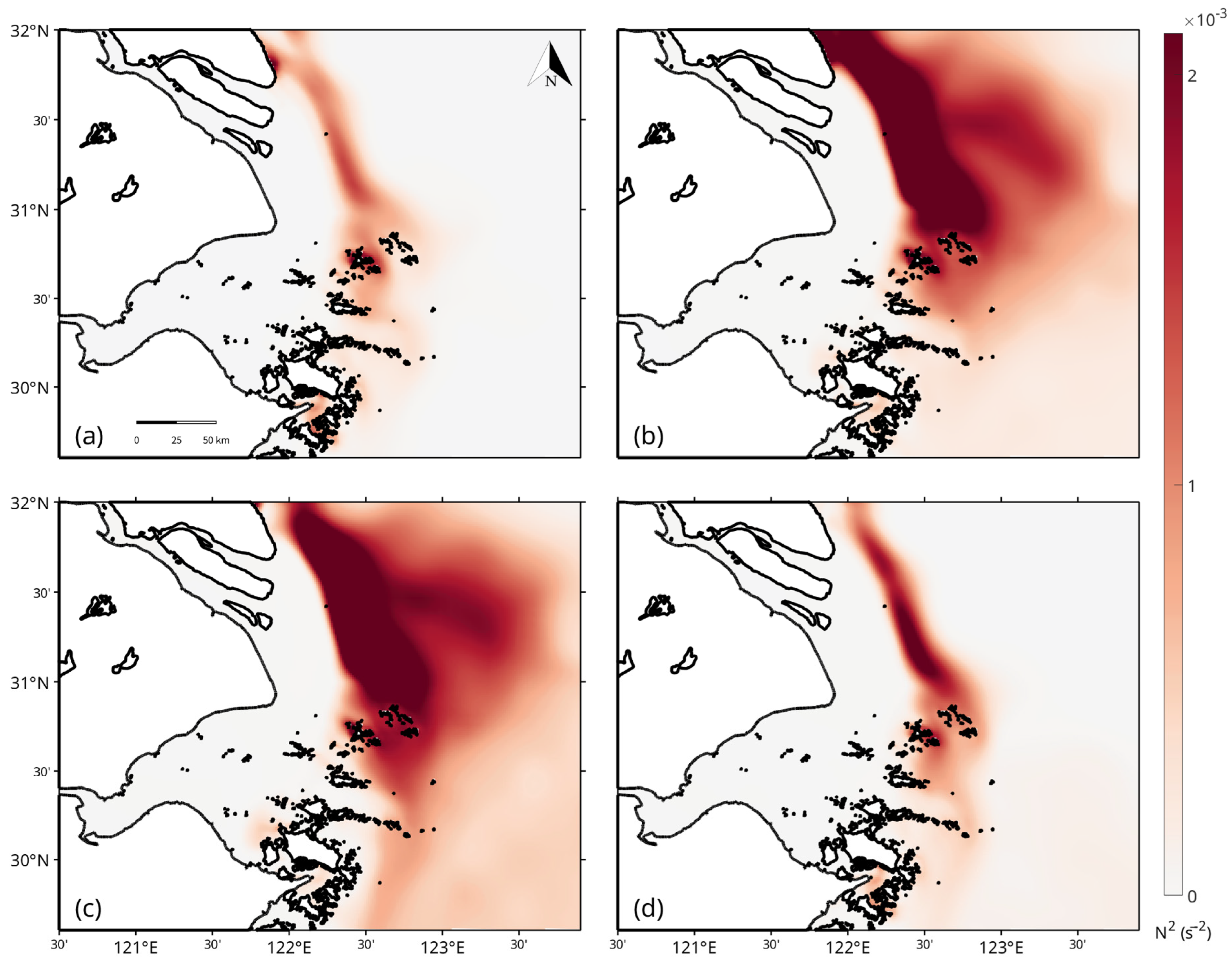
The strength of stratification is characterized using the vertically averaged buoyancy frequency N2 (Figure 4), also known as the Brunt–Väisälä frequency squared, the standard indicator of static stability. Winter N2 values are uniformly low across the domain (Figure 4a), reflecting a nearly homogeneous water column produced by cooling, wind mixing, and tidal stirring [39], with only weak residual stratification in plume-influenced areas (e.g., ~31° N, 122–123° E). Stratification begins to strengthen in spring (Figure 4b), reaching ~2 × 10⁻³ s−2 near the Yangtze plume front as surface warming and freshening stabilize the upper layer. Summer conditions exhibit the strongest stratification (Figure 4c), with N2 exceeding 2 × 10⁻³ s−2 over much of the shelf due to a warm, low-salinity surface lens over cooler, saltier water below [40]. In autumn (Figure 4d), N2 remains higher than in spring—particularly offshore—but weakens nearshore as cooling and mixing erode the summer stratification.

3.3. Tracer Transport and Vertical Distribution

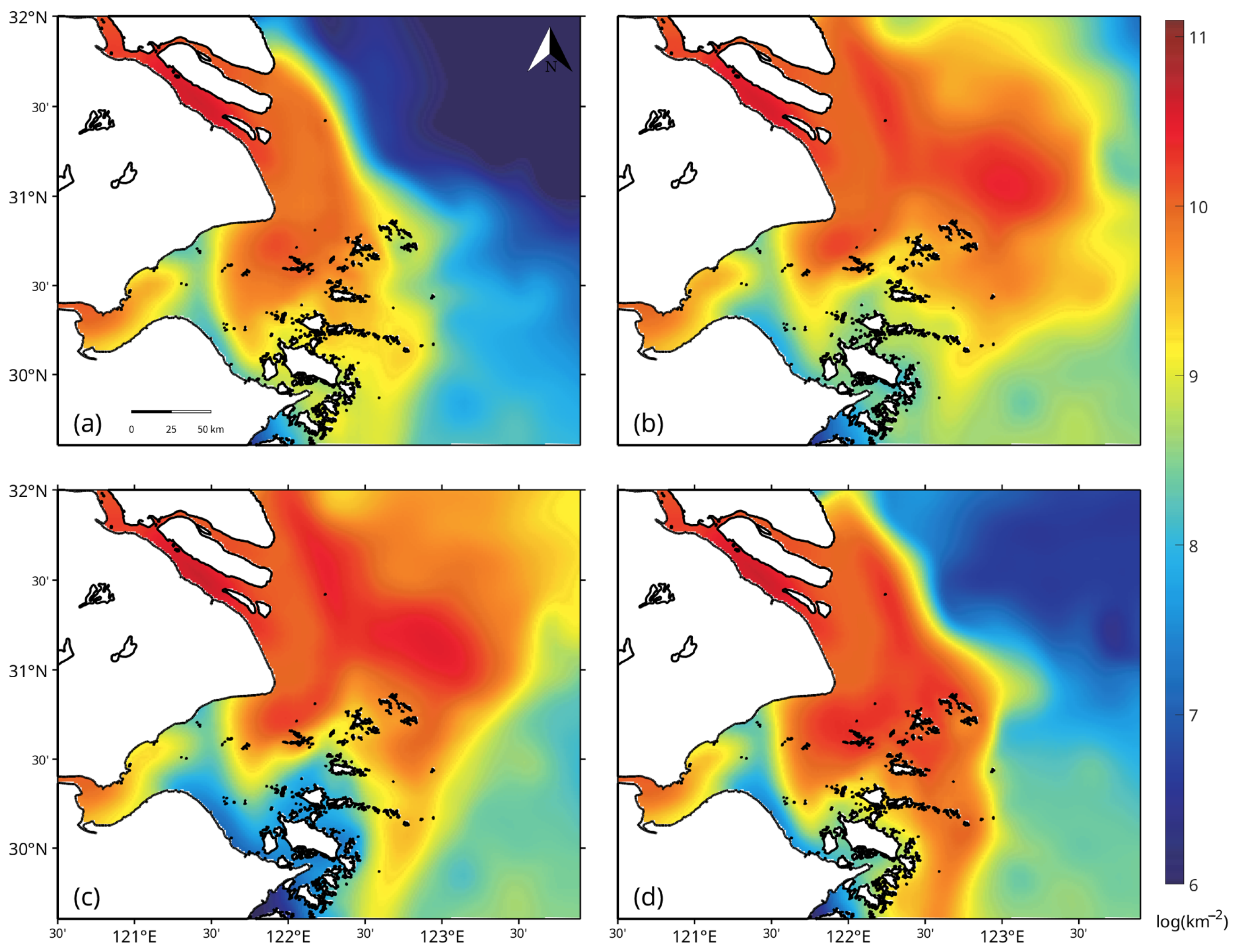
We now examine the fate of a passive antibiotic tracer (with a half-life of about one month) introduced via river discharges, highlighting how the physical circulation and stratification regimes influence its spread and retention. The seasonal mean vertically integrated tracer fields (Figure 5) reveal a clear modulation of horizontal spreading by river discharge and circulation. In winter (Figure 5a), river runoff is at its minimum, and the tracer plume is correspondingly weak. Elevated concentrations remain confined to the immediate vicinity of the Yangtze Estuary and Hangzhou Bay, with only a narrow coastal tongue extending southward along the Zhejiang–Fujian coast. Offshore transport is limited, consistent with reduced freshwater input and the dominance of strong vertical mixing. In spring (Figure 5b), increasing discharge and developing stratification enhance the offshore reach of the plume. The tracer begins to detach from the coast and spreads northeastward, mirroring the seasonal shift in the Changjiang Diluted Water (CDW). Summer (Figure 5c) presents the strongest dispersal, reflecting the combination of peak discharge and buoyancy-driven plume expansion. High tracer concentrations extend far offshore across the East China Sea shelf, highlighting the role of freshwater buoyancy forcing and weak wind-driven circulation in promoting widespread offshore contamination. By autumn (Figure 5d), the tracer field contracts again, as discharge decreases and the re-intensifying monsoon circulation re-establishes coastal confinement. These patterns demonstrate that the amplitude and seasonality of river runoff strongly regulate the offshore extent of antibiotic pollution.
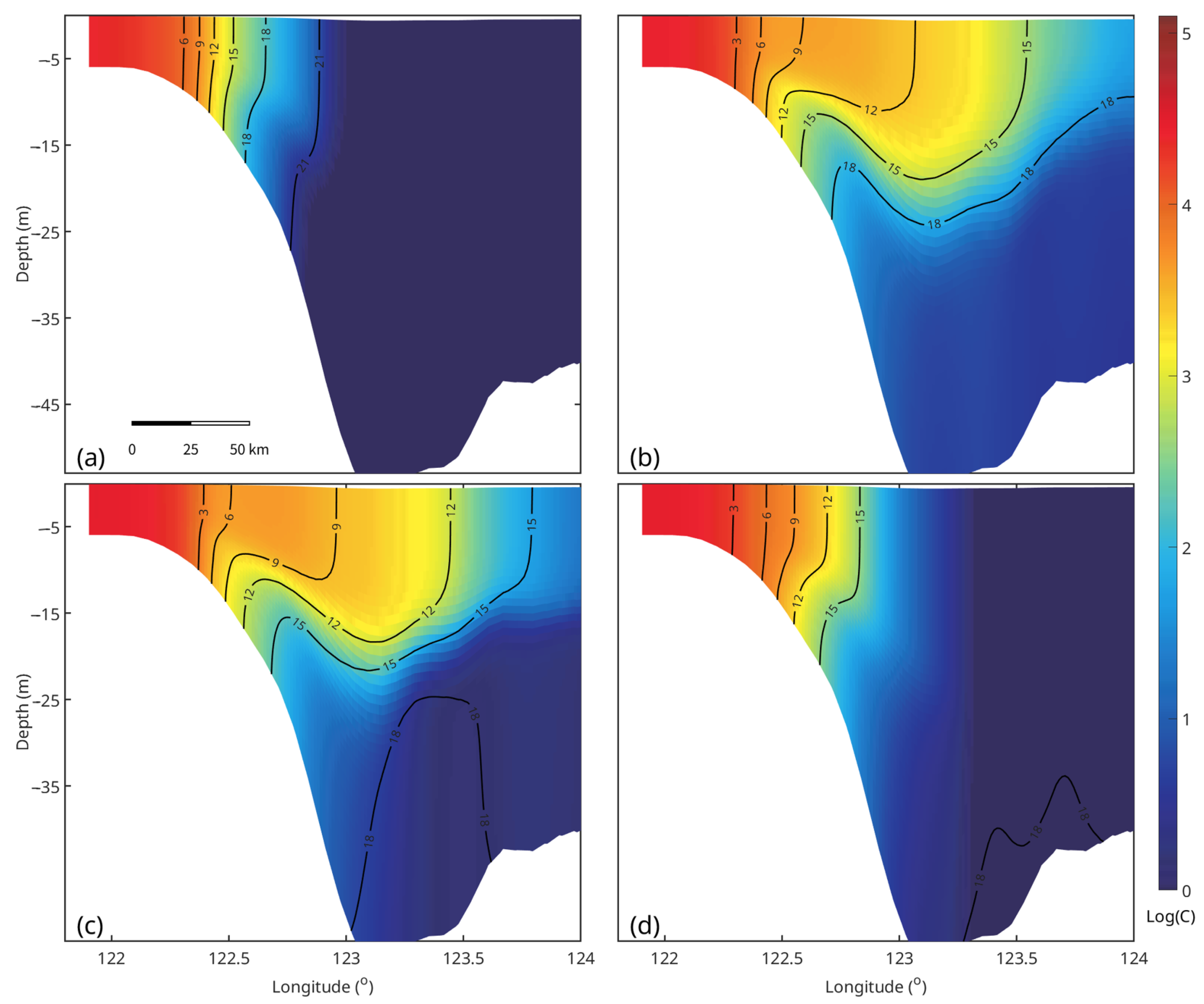
The zonal cross-sections at 31° N (Figure 6) add insight into the vertical structure of this seasonal variability. In winter (Figure 6a), the reduced freshwater flux results in a more spatially confined plume; concentrations remain high near the estuary but do not extend far offshore. Within the plume, however, weak stratification and strong vertical mixing distribute the tracer nearly uniformly from surface to bottom, allowing benthic waters to be exposed despite the limited horizontal spread. In spring (Figure 6b), as runoff strengthens and stratification develops, the plume becomes surface-intensified, with elevated concentrations capped above the pycnocline. Offshore transport follows the upper density layers, creating a buoyant corridor for tracer export. In summer (Figure 6c), the combination of maximum discharge and strong stratification results in a pronounced surface lens of antibiotics. High concentrations are trapped in the upper 5–10 m, spreading far offshore but remaining isolated from deeper layers. This confinement increases ecological risks in the euphotic zone while limiting benthic exposure. In autumn (Figure 6d), the breakdown of stratification permits partial downward mixing, but the tracer remains predominantly surface-oriented. Together, the sections illustrate how discharge magnitude sets the offshore reach, while stratification governs the vertical partitioning between surface retention and full-depth exposure. A qualitative comparison with published maps supports our simulated patterns. Yan et al. [4] reported a near-estuary maximum and rapid offshore dilution consistent with our tracer field. Guo et al. [5] similarly found higher concentrations near the outlets and decreasing levels seaward, indicating that our normalized tracer realistically captures the dominant spatial gradients in the Yangtze Estuary.
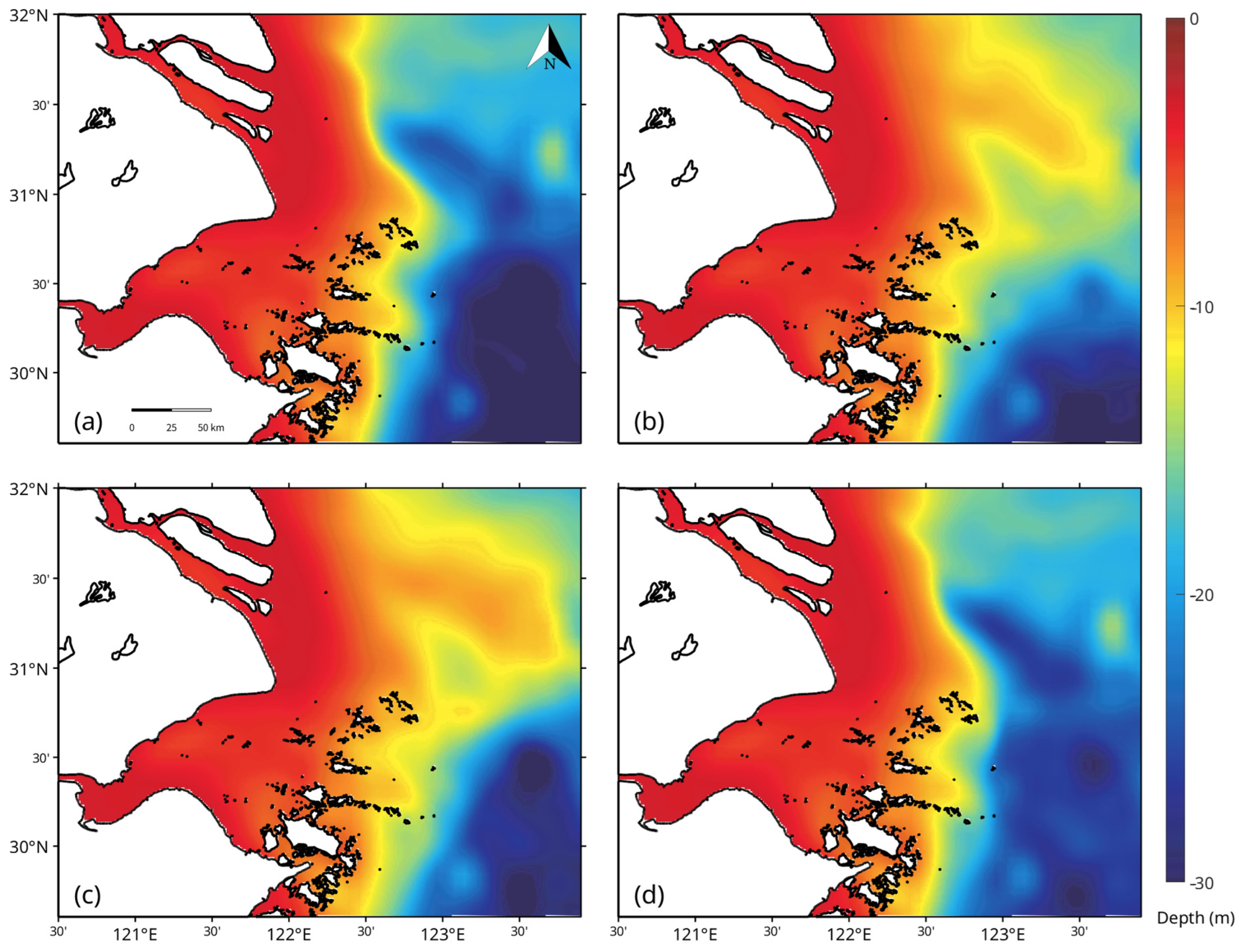
The vertical structure of the tracer plume also varies with season, as seen in Figure 7. In winter, the tracer’s center-of-mass (centroid depth) is much deeper offshore than inshore (Figure 7a). Near the river outlets and in shallow coastal waters, the tracer’s centroid remains very close to the surface (red colors, depth ~0 to −5 m) because the water column is shallow and the tracer is continuously supplied at the surface. However, further offshore (east of ~122.5° E in winter), the centroid depth increases to 20–30 m (green to blue colors). This indicates that in winter, the tracer is mixed downward through a much thicker layer of the water column on the outer shelf, as a result of strong wind and convective mixing, as well as tidal stirring that can carry surface-released tracer to the middle and lower water column. Essentially, winter conditions promote deep vertical penetration of the tracer plume, which in turn means the tracer is more diluted vertically (lower concentrations when averaged, as noted above) but also that some tracers can reach deeper waters. In summer, by contrast, the centroid depth is uniformly shallow across almost the entire plume region (Figure 7c). Even 100 km offshore, the tracer’s mean depth rarely exceeds ~10 m (yellow shades), and it remains <5 m in most of the plume near the coast (red-orange). The strong stratification in summer acts as a cap, trapping the tracer in the near-surface layer. Vertical mixing is weak, so the tracer stays in the top few meters, resulting in a very shallow centroid. This is maintaining higher surface concentrations (since the pollutant is not dispersed downward), but it also means the tracer is largely prevented from contacting the deeper ocean. Spring and autumn again show transitional behavior (Figure 7b,d). In spring, moderate stratification allows some downward mixing offshore, whereas autumn shows a still shallow plume with slightly increasing depth at the offshore edge as stratification weakens.
These results highlight the coupled influence of physical mechanisms (currents, density gradients, mixing) and tracer decay on the fate of the pollutant. In winter, fast advective transport by the coastal current leads to a shorter residence time of tracer in the source region, exporting it downstream (southward) before it can significantly decay. The vigorous vertical mixing in this season dilutes the tracer but also permits some of it to persist in deeper layers. In summer, conversely, the weaker currents and stratified ocean create a more retentive environment, where tracer-rich plume water remains on the ECS shelf for a longer period, allowing the typical antibiotic to substantially reduce the tracer mass as it slowly disperses. The strong halocline and thermocline in summer effectively isolate the tracer in the surface lens, leading to high concentrations near the source that can fuel local biological or chemical effects, yet this same stratification limits downward penetration, potentially reducing benthic impacts.

3.4. Particle-Tracking Pathways and Transport Timescales

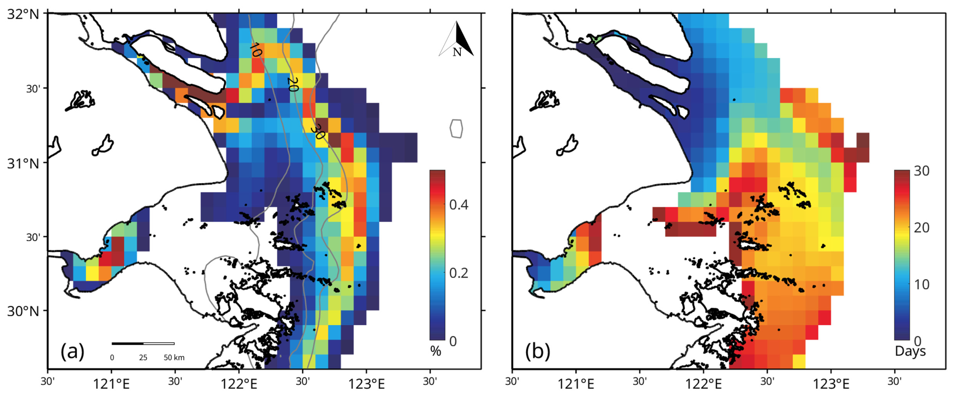
Lagrangian particle tracking corroborates and enriches the Eulerian tracer analysis by delineating specific transport pathways and timescales (Figure 8). The mean pathway field (Figure 8a) reveals sharply defined corridors of particle movement. Particles released from the Yangtze Estuary predominantly follow a narrow southward band along the ~30 m isobath immediately downstream of the estuary. Within this coastal corridor, particle occurrence values are highest (warm colors), indicating a persistent, well-traveled route. A secondary, much smaller “leakage” pathway branches offshore to the east, suggesting intermittent cross-shelf export of a small fraction of the plume beyond the 30 m contour. In contrast, particles from the Qiantang River exhibit a spatially constrained dispersion: the majority remain within Hangzhou Bay or its immediate outlet, reflecting the weak mean currents and partial enclosure of the bay. Only a limited portion of Qiantang particles escape into the open shelf, consistent with their long local retention.
The mean pathway field (Figure 8a) reveals sharply defined transport corridors. Yangtze-sourced particles are steered along the 30 m isobath in a southward band immediately downstream of the estuary. Within this coastal band, occurrence values are highest (warm colors), indicating a persistent and well-used route. A secondary leakage pathway is evident as a narrow corridor that peels offshore to the east, implying intermittent cross-front exchange that exports a small fraction of the plume beyond the 30 m contour. In contrast, particles released from the Qiantang River show a muted and spatially constrained pathway, where the highest occurrence remains within Hangzhou Bay and its immediate mouth, consistent with weak mean currents and the bay’s partial enclosure [41].
The average transit time map (Figure 8b) further highlights these differences. For Yangtze-released particles, travel times along the 30 m isobath south of the estuary are on the order of 5–10 days, indicating rapid downstream communication. Particles reach the offshore leakage corridor within a similar timeframe. Most Yangtze particles can traverse on the order of 100 km (to the Zhoushan coastal region) within about one month. By contrast, Qiantang particles show much longer transit times: many areas just outside Hangzhou Bay are not reached within the 30-day simulation, and those that do exit the bay take several weeks to move tens of kilometers. This underscores the strong trapping of material within Hangzhou Bay and the very slow export of its waters to the shelf.
These Lagrangian diagnostics translate the seasonal hydrodynamic setting into actionable connectivity maps, identifying the corridors most likely to advect pollutants and the coastal sectors that receive early exposure. Meanwhile, by placing the transport times on the same order as the one-month half-life considered here, they provide a timescale-aware expectation for persistence: Yangtze-sourced antibiotics can traverse O (100 km) along the 30 m isobath before a half-life has elapsed, whereas Qiantang-sourced antibiotics experience prolonged near-source exposure and accumulation. The persistence of the isobath-following band and the weak exchange out of Hangzhou Bay clarify where monitoring and mitigation will be most effective along the 30 m contour south of the Yangtze mouth for down-coast export, and at the bay mouth for Qiantang-driven retention and episodic release.
Our findings are in strong alignment with the established literature on regional hydrodynamics, and our study’s innovation lies in connecting this physical framework to contaminant fate. The simulated seasonal dichotomy of the Yangtze plume, exhibiting a confined, southward coastal current in winter and a broad, northeastward-spreading plume in summer, is a well-documented feature consistent with foundational observational and modeling studies [24,37,38]. Our Lagrangian results, which identify the 30 m isobath as a primary southward conveyor, are also supported by recent high-resolution transport modeling [34]. Furthermore, our conclusion of long residence times and local accumulation within Hangzhou Bay corroborates findings from other hydrodynamic and water quality models specific to this embayment [41]. Our work does not conflict with these studies; rather, it builds upon them by providing the physical mechanisms that explain the fate of pollutants. While field studies have confirmed the presence of antibiotics [4,5], our study provides the explicit transport pathways and timescales, offering a new, timescale-aware interpretation of transport behavior by comparing transport times (e.g., 5–10 days) with degradation half-lives (~31 days).

4. Summary and Discussion

Our simulations show that estuarine circulation, stratification, and vertical mixing collectively exert primary control over the fate and persistence of antibiotic-like tracers. Strong summer stratification confines contaminants to the surface layer, intensifying exposure for pelagic organisms, whereas winter mixing promotes deeper penetration and enhanced benthic exposure. These seasonally varying hydrodynamic conditions largely dictate whether surface or benthic communities experience greater contaminant loading.
The Yangtze plume is rapidly advected southward along the 30 m isobath, with intermittent offshore leakage transporting surface-borne contaminants across distant shelf waters within days. This broad, far-field dispersal contrasts with the Qiantang River discharge, which remains largely trapped within Hangzhou Bay, leading to localized accumulation and chronic exposure. The spatial partitioning of transport pathways underscores the Yangtze River’s dominant role in regional contaminant export.
Even under idealized decay assumptions that omit photolysis and sediment–water exchange, hydrodynamic processes substantially prolong the effective environmental persistence of antibiotics by retaining tracers in biologically active zones. The comparison between transport timescales and degradation timescales highlights that physical process including via flushing, stratification, and vertical exchange, can govern contaminant fate as strongly as chemical decay, with implications for chronic, sublethal exposure and potential enrichment of antibiotic resistance genes.
Although this study emphasizes hydrodynamic controls under typical seasonal conditions, unmodeled processes would mainly adjust concentrations rather than alter transport geometry. Sediment adsorption would increase near-source retention in Hangzhou Bay, while photodegradation would shorten surface-layer persistence in summer without changing plume pathways. Reasonable variations in decay half-life (20–40 days) would scale concentrations but not modify spreading [13,14], because Yangtze advection (5–10 days) is much faster than degradation [2]. Episodic winds or discharge would enhance mixing but not overturn the contrast between rapid Yangtze export and long Qiantang retention. Overall, the main pathways remain robust.
Future model developments should incorporate sediment interaction, optical radiative transfer for photolysis, submesoscale mixing, and high-frequency forcing such as storms and episodic runoff events. Coupling the present hydrodynamic framework with biogeochemical modules and temporally resolved discharge datasets will enable more realistic exposure assessments. These advances will support targeted monitoring along key transport corridors and improved management of both local accumulation and regional export of pharmaceuticals in the East China Sea.

Supplementary Materials

The following supporting information can be downloaded at: https://www.mdpi.com/article/10.3390/w17233384/s1, Figure S1: Simulated climatological monthly mean surface currents and sea surface temperature for February, May, August, and November; Figure S2: Simulated climatological monthly mean surface currents and sea surface salinity for February, May, August, and November.

Author Contributions

Conceptualization, X.F. and P.Z.; methodology, J.S.; validation, J.S.; formal analysis, X.F. and H.Z.; investigation, X.F. and H.Z.; writing—original draft preparation, X.F.; writing, review and editing, J.S.; visualization, H.Z.; supervision, P.Z.; funding acquisition, P.Z. All authors have read and agreed to the published version of the manuscript.

Funding

This work was supported by the National Key R&D Program of China (no. 2022YFC3105800).

Data Availability Statement

The original contributions presented in this study are included in the article/Supplementary Material. Further inquiries can be directed to the corresponding author.

Conflicts of Interest

The authors declare no conflicts of interest.

Abbreviations

The following abbreviations are used in this manuscript:
ARGsantibiotic resistance genes
CMSConnectivity Modeling System
CDWChangjiang Diluted Water
ECSEast China Sea
ECMWFEuropean Centre for Medium-Range Weather Forecasts
ROMSRegional Ocean Modeling System
YREYangtze River Estuary

References

  1. Kuang, C.; Chen, K.; Wang, J.; Wu, Y.; Liu, X.; Xia, Z. Responses of Hydrodynamics and Saline Water Intrusion to Typhoon Fongwong in the North Branch of the Yangtze River Estuary. Appl. Sci. 2021, 11, 8986. [Google Scholar] [CrossRef]
  2. Liu, Z.; Gan, J.; Wu, H.; Hu, J.; Cai, Z.; Deng, Y. Advances on Coastal and Estuarine Circulations Around the Changjiang Estuary in the Recent Decades (2000–2020). Front. Mar. Sci. 2021, 8, 615929. [Google Scholar] [CrossRef]
  3. Yang, Q.; Gao, Y.; Ke, J.; Show, P.L.; Ge, Y.; Liu, Y.; Guo, R.; Chen, J. Antibiotics: An Overview on the Environmental Occurrence, Toxicity, Degradation, and Removal Methods. Bioengineered 2021, 12, 7376–7416. [Google Scholar] [CrossRef] [PubMed]
  4. Yan, C.; Yang, Y.; Zhou, J.; Liu, M.; Nie, M.; Shi, H.; Gu, L. Antibiotics in the Surface Water of the Yangtze Estuary: Occurrence, Distribution and Risk Assessment. Environ. Pollut. 2013, 175, 22–29. [Google Scholar] [CrossRef] [PubMed]
  5. Guo, X.; Feng, C.; Gu, E.; Tian, C.; Shen, Z. Spatial Distribution, Source Apportionment and Risk Assessment of Antibiotics in the Surface Water and Sediments of the Yangtze Estuary. Sci. Total Environ. 2019, 671, 548–557. [Google Scholar] [CrossRef]
  6. Marti, E.; Variatza, E.; Balcazar, J.L. The Role of Aquatic Ecosystems as Reservoirs of Antibiotic Resistance. Trends Microbiol. 2014, 22, 36–41. [Google Scholar] [CrossRef]
  7. Guo, X.; Zhao, S.; Chen, Y.; Yang, J.; Hou, L.; Liu, M.; Yang, Y. Antibiotic Resistance Genes in Sediments of the Yangtze Estuary: From 2007 to 2019. Sci. Total Environ. 2020, 744, 140713. [Google Scholar] [CrossRef]
  8. Yin, Z. Distribution and Ecological Risk Assessment of Typical Antibiotics in the Surface Waters of Seven Major Rivers, China. Environ. Sci. Process. Impacts 2021, 23, 1088–1100. [Google Scholar] [CrossRef]
  9. Li, Z.; Li, M.; Zhang, Z.; Li, P.; Zang, Y.; Liu, X. Antibiotics in Aquatic Environments of China: A Review and Meta-Analysis. Ecotoxicol. Environ. Saf. 2020, 199, 110668. [Google Scholar] [CrossRef]
  10. Shang, J.; Huang, M.; Zhao, L.; He, P.; Liu, Y.; Pan, H.; Cao, S.; Liu, X. Adsorption Performance and Mechanisms of Tetracycline on Clay Minerals in Estuaries and Nearby Coastal Areas. ACS Omega 2024, 9, 692–699. [Google Scholar] [CrossRef]
  11. Liu, J.; Deng, W.-J.; Ying, G.-G.; Tsang, E.P.K.; Hong, H.-C. Occurrence and Distribution of Antibiotics in Surface Water. Ecotoxicology 2022, 31, 1111–1119. [Google Scholar] [CrossRef] [PubMed]
  12. Maghsodian, Z.; Sanati, A.M.; Mashifana, T.; Sillanpää, M.; Feng, S.; Nhat, T.; Ramavandi, B. Occurrence and Distribution of Antibiotics in the Water, Sediment, and Biota of Freshwater and Marine Environments: A Review. Antibiotics 2022, 11, 1461. [Google Scholar] [CrossRef]
  13. Hu, J.; Li, S.; Zhang, W.; Helbling, D.E.; Xu, N.; Sun, W.; Ni, J. Animal Production Predominantly Contributes to Antibiotic Profiles in the Yangtze River. Water Res. 2023, 242, 120214. [Google Scholar] [CrossRef]
  14. Liu, Y.; Zhang, M.; Wu, Y.; Li, S.; Hu, J.; Sun, W.; Ni, J. Profiles, Drivers, and Prioritization of Antibiotics in China’s Major Rivers. J. Hazard. Mater. 2024, 477, 135399. [Google Scholar] [CrossRef]
  15. Dai, C.; Han, Y.; Li, Y.; Duan, Y.; Liu, S.; Zhang, Y.; Tu, Y. Simulation and Risk Assessment of Typical Antibiotics in the Multi-Media Environment of the Yangtze River Estuary under Tidal Effect. Environ. Sci. Pollut. Res. 2022, 29, 81875–81891. [Google Scholar] [CrossRef]
  16. Zhang, Z.-B.; Duan, Y.-P.; Zhang, Z.-J.; Tu, Y.-J.; Luo, P.-C.; Gao, J.; Dai, C.-M.; Zhou, L. Multimedia Fate Model and Risk Assessment of Typical Antibiotics in the Integrated Demonstration Zone of the Yangtze River Delta, China. Sci. Total Environ. 2022, 805, 150258. [Google Scholar] [CrossRef]
  17. Sun, J.; Wei, Z.; Xu, T.; Sun, M.; Liu, K.; Yang, Y.; Chen, L.; Zhao, H.; Yin, X.; Feng, W.; et al. Development of a Fine-Resolution Atmosphere-Wave-Ocean Coupled Forecasting Model for the South China Sea and Its Adjacent Seas. Acta Oceanol. Sin. 2019, 38, 154–166. [Google Scholar] [CrossRef]
  18. Chen, Y.-R.; Duan, Y.-P.; Zhang, Z.-B.; Gao, Y.-F.; Dai, C.-M.; Tu, Y.-J.; Gao, J. Comprehensive Evaluation of Antibiotics Pollution the Yangtze River Basin, China: Emission, Multimedia Fate and Risk Assessment. J. Hazard. Mater. 2024, 465, 133247. [Google Scholar] [CrossRef] [PubMed]
  19. Li, S.; Zhu, Y.; Zhong, G.; Huang, Y.; Jones, K.C. Comprehensive Assessment of Environmental Emissions, Fate, and Risks of Veterinary Antibiotics in China: An Environmental Fate Modeling Approach. Environ. Sci. Technol. 2024, 58, 5534–5547. [Google Scholar] [CrossRef]
  20. Addis, T.Z.; Adu, J.T.; Kumarasamy, M.; Demlie, M. Assessment of Existing Fate and Transport Models for Predicting Antibiotic Degradation and Transport in the Aquatic Environment: A Review. Water 2023, 15, 1511. [Google Scholar] [CrossRef]
  21. Bagi, A.; Pampanin, D.M.; Brakstad, O.G.; Kommedal, R. Estimation of Hydrocarbon Biodegradation Rates in Marine Environments: A Critical Review of the Q10 Approach. Mar. Environ. Res. 2013, 89, 83–90. [Google Scholar] [CrossRef] [PubMed]
  22. Batchu, S.R.; Panditi, V.R.; O’Shea, K.E.; Gardinali, P.R. Photodegradation of Antibiotics under Simulated Solar Radiation: Implications for Their Environmental Fate. Sci. Total Environ. 2014, 470–471, 299–310. [Google Scholar] [CrossRef] [PubMed]
  23. Ge, L.; Chen, J.; Qiao, X.; Lin, J.; Cai, X. Light-Source-Dependent Effects of Main Water Constituents on Photodegradation of Phenicol Antibiotics: Mechanism and Kinetics. Environ. Sci. Technol. 2009, 43, 3101–3107. [Google Scholar] [CrossRef]
  24. Liu, C.; Tan, L.; Zhang, L.; Tian, W.; Ma, L. A Review of the Distribution of Antibiotics in Water in Different Regions of China and Current Antibiotic Degradation Pathways. Front. Environ. Sci. 2021, 9, 692298. [Google Scholar] [CrossRef]
  25. Paris, C.B.; Helgers, J.; Van Sebille, E.; Srinivasan, A. Connectivity Modeling System: A Probabilistic Modeling Tool for the Multi-Scale Tracking of Biotic and Abiotic Variability in the Ocean. Environ. Model. Softw. 2013, 42, 47–54. [Google Scholar] [CrossRef]
  26. Zhan, P.; Yao, F.; Kartadikaria, A.R.; Viswanadhapalli, Y.; Gopalakrishnan, G.; Hoteit, I. Far-Field Ocean Conditions and Concentrate Discharges Modeling Along the Saudi Coast of the Red Sea. In Intakes and Outfalls for Seawater Reverse-Osmosis Desalination Facilities; Missimer, T.M., Jones, B., Maliva, R.G., Eds.; Environmental Science and Engineering; Springer International Publishing: Cham, Switzerland, 2015; pp. 501–520. ISBN 978-3-319-13202-0. [Google Scholar]
  27. Zhan, P.; Krokos, G.; Langodan, S.; Guo, D.; Dasari, H.; Papadopoulos, V.P.; Lermusiaux, P.F.J.; Knio, O.M.; Hoteit, I. Coastal Circulation and Water Transport Properties of the Red Sea Project Lagoon. Ocean. Model. 2021, 161, 101791. [Google Scholar] [CrossRef]
  28. Lin, Z.; Zhan, P.; Li, J.; Sasaki, J.; Qiu, Z.; Chen, C.; Zou, S.; Yang, X.; Gu, H. Physical Drivers of Noctiluca Scintillans (Dinophyceae) Blooms Outbreak in the Northern Taiwan Strait: A Numerical Study. Harmful Algae 2024, 133, 102586. [Google Scholar] [CrossRef] [PubMed]
  29. Carstens, K.L.; Gross, A.D.; Moorman, T.B.; Coats, J.R. Sorption and Photodegradation Processes Govern Distribution and Fate of Sulfamethazine in Freshwater–Sediment Microcosms. Environ. Sci. Technol. 2013, 47, 10877–10883. [Google Scholar] [CrossRef]
  30. Grimmett, M.E. Adsorption of Sulfamethazine from Environmentally Relevant Aqueous Matrices onto Hypercrosslinked Adsorbent MN250. J. Environ. Qual. 2015, 44, 1183–1192. [Google Scholar] [CrossRef]
  31. Harrower, J.; McNaughtan, M.; Hunter, C.; Hough, R.; Zhang, Z.; Helwig, K. Chemical Fate and Partitioning Behavior of Antibiotics in the Aquatic Environment—A Review. Environ. Toxicol. Chem. 2021, 40, 3275–3298. [Google Scholar] [CrossRef]
  32. Figueroa, H.A. World Ocean Density Ratios. J. Phys. Oceanogr. 1996, 26, 267–275. [Google Scholar] [CrossRef]
  33. Rudnick, D.L.; Martin, J.P. On the Horizontal Density Ratio in the Upper Ocean. Dyn. Atmos. Ocean. 2002, 36, 3–21. [Google Scholar] [CrossRef]
  34. Wu, R.; Wu, H.; Wang, Y. Modulation of Shelf Circulations Under Multiple River Discharges in the East China Sea. JGR Ocean. 2021, 126, e2020JC016990. [Google Scholar] [CrossRef]
  35. Zhang, L.; Yang, Z.; Zhang, F.; Li, Z.; Wang, Y.; Gao, S. Longitudinal Residual Circulation in the South Passage of Yangtze Estuary: Combined Influences from Runoff, Tide and Bathymetry. Sci. China Earth Sci. 2021, 64, 2129–2143. [Google Scholar] [CrossRef]
  36. Yanagi, T.; Takahashi, S. Seasonal Variation of Circulations in the East China Sea and the Yellow Sea. J. Oceanogr. 1993, 49, 503–520. [Google Scholar] [CrossRef]
  37. Beardsley, R.C.; Limeburner, R.; Yu, H.; Cannon, G.A. Discharge of the Changjiang (Yangtze River) into the East China Sea. Cont. Shelf Res. 1985, 4, 57–76. [Google Scholar] [CrossRef]
  38. Park, S.; Chu, P.C. Thermal and Haline Fronts in the Yellow/East China Seas: Surface and Subsurface Seasonality Comparison. J. Oceanogr. 2006, 62, 617–638. [Google Scholar] [CrossRef]
  39. Nguyen, M.; Johnson, E.R. The Dispersive Potential-Vorticity Dynamics of Coastal Outflows. J. Fluid Mech. 2025, 1010, A39. [Google Scholar] [CrossRef]
  40. Lozovatsky, I.; Lee, J.; Fernando, H.J.S.; Kang, S.K.; Jinadasa, S.U.P. Turbulence in the E Ast C Hina S Ea: T He Summertime Stratification. JGR Ocean. 2015, 120, 1856–1871. [Google Scholar] [CrossRef]
  41. Fang, Z.; Feng, T.; Qin, G.; Meng, Y.; Zhao, S.; Yang, G.; Wang, L.; Sun, W. Simulations of Water Pollutants in the Hangzhou Bay, China: Hydrodynamics, Characteristics, and Sources. Mar. Pollut. Bull. 2024, 200, 116140. [Google Scholar] [CrossRef]
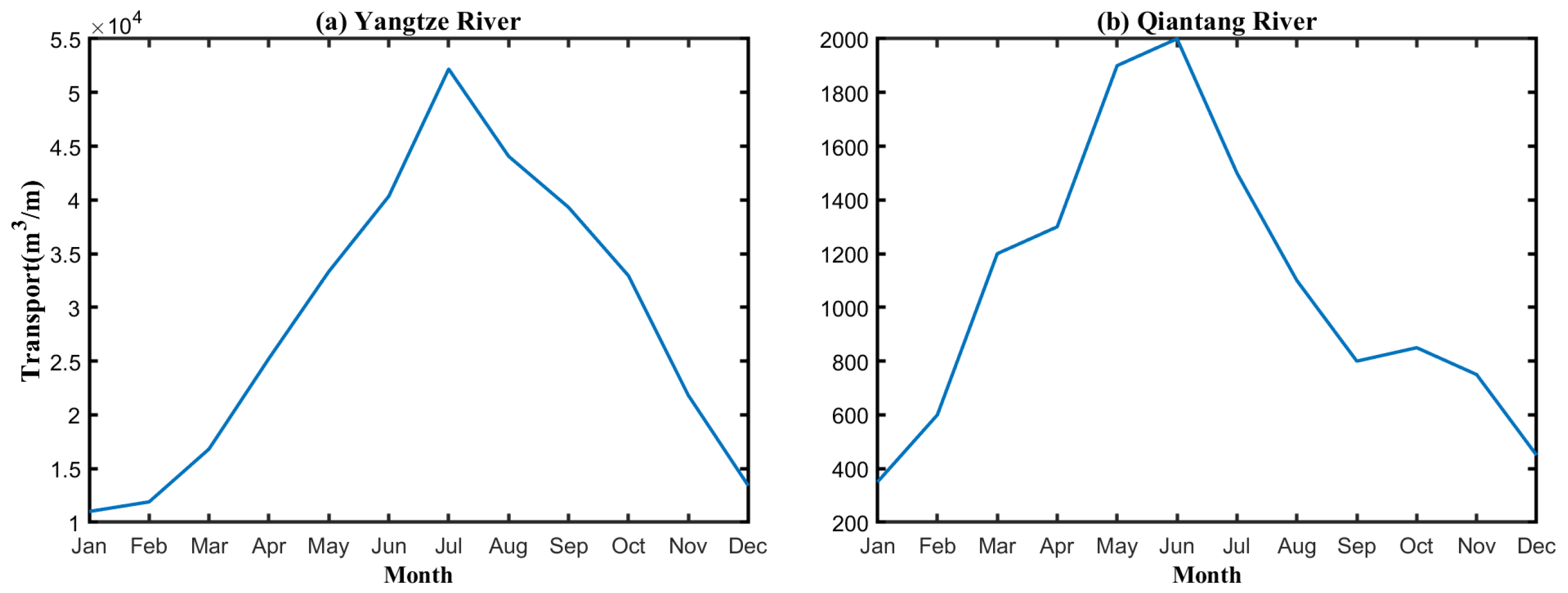
Figure 1. Monthly mean river discharge of the (a) Yangtze River and (b) Qiantang River.
Water 17 03384 g001
Figure 2. Seasonal mean vertically averaged currents (vectors) and water potential density (shading, kg m−3) over the Yangtze River estuary and adjacent East China Sea. Panels show (a) winter, (b) spring, (c) summer, and (d) autumn, averaged over the 5-year simulation. This figure, together with the subsequent figure, was generated using MATLAB 2022B.
Water 17 03384 g002
Figure 3. Seasonal mean log10 of the absolute density ratio (log10| R ρ |), vertically averaged over the water column in (a) winter, (b) spring, (c) summer, and (d) autumn, averaged over the 5-year simulation. log10| R ρ | > 0.3 indicate haline stratification, log10| R ρ | < −0.3 indicate thermal stratification, and values between −0.3 and 0.3 indicate weak net stratification due to temperature-salinity compensation.
Water 17 03384 g003
Figure 4. Seasonal mean buoyancy frequency squared (N2) vertically averaged over the water column in (a) winter, (b) spring, (c) summer, and (d) autumn, averaged over the 5-year simulation.
Water 17 03384 g004
Figure 5. Seasonal mean vertically integrated antibiotic tracer concentration (log10 scale, km−2) in (a) winter, (b) spring, (c) summer, and (d) autumn, averaged over the 5-year simulation. Concentrations reflect the combined influence of riverine input, advection, mixing, and temperature-dependent decay.
Water 17 03384 g005
Figure 6. Seasonal zonal cross-sections of tracer concentration and density anomaly along 31° N. Panels (a) winter, (b) spring, (c) summer, and (d) autumn show log10 tracer concentrations. Here, C denotes the tracer concentration (color shading, arbitrary units) overlaid with density anomalies (con-tours, kg m−3 relative to 1000).
Water 17 03384 g006
Figure 7. Seasonal mean centroid depth (m) of the antibiotic tracer concentration in (a) winter, (b) spring, (c) summer, and (d) autumn. The centroid depth represents the vertical center of mass of the tracer distribution, providing insight into the depth-dependent retention and isolation of the contaminant.
Water 17 03384 g007
Figure 8. Mean pathways (a) and transit time (b) computed by keep tracking of passive particles release from the Yangtze River Estuary and Qiantang River Estuary in August. Mean pathway is defined as the percentage of released particles that passed through each grid cell during the 30 days; the average transit time represents the mean time required for particles from each source to reach a given grid cell.
Water 17 03384 g008
Disclaimer/Publisher’s Note: The statements, opinions and data contained in all publications are solely those of the individual author(s) and contributor(s) and not of MDPI and/or the editor(s). MDPI and/or the editor(s) disclaim responsibility for any injury to people or property resulting from any ideas, methods, instructions or products referred to in the content.