Article

Impact of Deep-Rooted Vegetation on Deep Soil Water Recharge in the Gully Region of the Loess Plateau

1
Institute of Water-Saving Agriculture in Arid Areas of China, Northwest A&F University, Xianyang 712100, China
2
Key Laboratory of Agricultural Soil and Water Engineering in Arid and Semiarid Areas, Ministry of Education, Northwest A&F University, Xianyang 712100, China
3
Shaanxi Provincial Land Engineering Construction Group Co., Ltd., Xi’an 710075, China
*
Authors to whom correspondence should be addressed.
Water 2025, 17(2), 208; https://doi.org/10.3390/w17020208
Submission received: 8 December 2024 / Revised: 10 January 2025 / Accepted: 13 January 2025 / Published: 14 January 2025

Abstract

:
To investigate the impacts of vegetation change on deep soil water recharge, it is essential to identify the sources of deep soil water and deep drainage. The combination of stable and radioactive water isotopes is an effective method for studying deep vadose zones, though it has been rarely applied in complex gully areas. In this study, we measured δ2H, δ18O, and 3H in soil water under long-term natural grassland and C. korshinskii on the same slope. Both natural grassland and C. korshinskii plots received deep soil water from rainfall during the rainy season; however, the replenishment thresholds for soil water at depths of 2–10.4 m differed between the two vegetation types, corresponding to rainfall intensities of ≥20 mm and ≥50 mm, respectively. Following the conversion of natural grassland to C. korshinskii vegetation, the rate of soil water storage deficit increased by 46.4 mm yr−1, and deep drainage shifted from 39.6 mm yr−1 to 0 mm yr−1. Deep-rooted vegetation significantly depletes soil water to meet transpiration demands, thus hindering rainfall recharge. These findings have important implications for water and land resource management, especially in areas undergoing significant vegetation changes.

1. Introduction

Soil water, constituting only 0.05% of the global freshwater supply [1], plays a crucial role in the terrestrial hydrological cycle. It supports vegetation growth [2] and acts as a vital link between the atmosphere and groundwater systems, facilitating the transfer and transformation of materials and energy [3]. Soil water dynamics are highly variable and significantly influenced by human activities and climatic conditions [4]. In particular, large-scale land use changes driven by human activities are major drivers of alterations in soil hydrological processes [5,6]. Understanding how soil hydrological processes change in response to land use alterations is therefore essential for effective water resource management.
Vegetation restoration is regarded as a viable solution to address land degradation and climate change [7]. Over the past three decades, the Loess Plateau has become one of the regions most affected by human-induced land use changes [8,9]. The implementation of grain plots to forestry and a program to recover and rebuild the ecological environment has led to the transition from shallow-rooted crops or grasses to deep-rooted plants [10,11]. However, this transition has allowed deep-rooted plants to access deeper soil water resources, exacerbating water scarcity in deep soil layers, particularly in arid regions, which in turn affects vegetation health and leads to further land degradation [12,13]. Against this backdrop, a thorough study of deep soil water recharge mechanisms is essential to understand the changes in soil hydrological processes following the establishment of deep-rooted vegetation in the Loess Plateau.
The Loess Plateau is renowned for its thick vadose zone [14], but the identification of deep soil water recharge (sources, pathways, fluxes, and ages) in regions with deep unsaturated zones remains challenging due to limitations in current analytical techniques [15,16]. This challenge impedes a thorough understanding of the interplay between deep soil water recharge mechanisms and vegetation changes. Stable water isotopes (δ2H and δ18O) have emerged as powerful tools in hydrology due to their unique fingerprints in the water cycle, which reflect processes such as water source identification, evaporation, and mixing [17,18]. These isotopes have been widely applied to the qualitative and quantitative analysis of hydrological processes [19,20,21]. Furthermore, radioactive isotopes like 3H are used to determine the age and recharge rates of soil water [22,23]. The combined use of stable and radioactive isotopes offers a powerful approach for both qualitative and quantitative analyses of soil water recharge mechanisms. While hydrological tracing techniques have been applied to study soil hydrological processes in the Loess Plateau, much of the research has focused on the loess tableland areas [24,25,26], with relatively little attention given to soil water under vegetation changes in the gully regions.
This study investigates the effects of deep-rooted vegetation on the recharge processes of deep soil water in the gully regions of the Loess Plateau. To this end, we measured δ2H, δ18O, and tritium (3H) isotopes in soil water from long-term natural grasslands and the deep-rooted C. korshinskii on the same slope. By combining these isotopic data, we seek to answer two key questions: (1) How can the joint use of stable and radioactive water isotopes enhance our understanding of deep soil water recharge? (2) In what ways does deep-rooted vegetation affect the recharge of deep soil water? The results of this study offer valuable insights into the sustainable management of vegetation and water resources, both in the Loess Plateau and other regions with comparable environmental conditions.

2. Materials and Methods

2.1. Study Site

This study took place in the Xindiangou watershed (37°31′ N, 110°17′ E) located in Suide County, central Chinese Loess Plateau (Figure 1a). This region experiences a semi-arid climate, characterized by a temperate continental monsoon weather pattern. The average elevation stands at 745 m. Over the period from 1985 to 2020, the mean annual temperature was recorded at 10.1 °C, while the average annual rainfall amounted to 444.4 mm. The soil type is calcareous silt loam, originating from loess parent material, which is classified as Calcic Luvisols. The watershed’s topography is deeply dissected by numerous gullies, with loess hills occupying 77.8% of the total land area. The groundwater table is situated at a depth of over 100 m, making precipitation the sole source of water for vegetation growth.

2.2. Samples Collection and Analysis

2.2.1. Precipitation Samples

Precipitation samples were collected at a location located 29.7 km away near the soil sampling site (Figure 1a) from 2016 to 2020. A device that has a bottle connected to a rainwater funnel, with a ping pong ball placed in the funnel, is used to collect rainwater and minimize evaporation. The collected samples were placed in 250 mL high-density polyethylene bottles and stored in a refrigerator before further isotope analysis. A total of 179 precipitation samples were collected and analyzed.

2.2.2. Soil and Root Samples

We selected a long-term natural grassland, which has the same site conditions and is located on the same eastward slope with a gradient of 32° and an altitude of 980 m (Figure 1b and Table 1), and C. korshinskii planted in 1985. In order to avoid the influence of soil spatial variation, fixed sampling areas were designed for the two vegetation types at mid to uphill positions. The soil and root samples of each plot were drilled with a hollow-stem auger at a sampling interval of 0.2 m to a depth of 22 m in July 2020. A part of the soil samples was placed in an aluminum container to determine soil water content, while the remainder was stored in plastic bottles and frozen at –20 °C for later isotopic analysis. To assess the vertical distribution of fine roots of C. korshinskii, root samples, mixed with soil, were collected and carefully washed with tap water over a 1 mm sieve. Cleaned roots were then meticulously selected using tweezers and scanned at a resolution of 300 dpi. The resulting images were analyzed utilizing WinRHIZO 2019a image analysis software to quantify root length. Finally, fine root length density (FRLD) was determined by dividing the total root length by the volume of soil core sampled.

2.2.3. Isotopic Analysis

Water from the soil samples was extracted by vacuum condensation extraction system (LI-2000). The extracted soil water and precipitation were filtrated with a 0.22 μm filter and transferred to 1.5 mL glass bottles. The δ2H and δ18O in precipitation and soil water were measured by an off-axis integrated cavity output spectroscopy water isotope analyzer (LWA-45EP, Los Gatos Research, CA, USA). The measured δ18O and δ2H are expressed in δ of the difference relative to the Vienna Standard Mean Ocean Water (VSMOW). The accuracy of measurement is ±1‰ for δ2H and ±0.2‰ for δ18O, respectively. We collected roughly 8 mL of soil water, combined it with a scintillation cocktail (Hisafe3) at a proportion of 8:12, and kept it in darkness for 12 h before conducting the analysis. The sample was then assessed with a low-background liquid scintillation counter (model Quantulus 1220, manufactured by PerkinElmer in Jurong, Singapore) for a duration of 400 min. Following the adjustment for background interference, the detected tritium activities, expressed in counts per minute, were converted into tritium units.

2.3. Identifying Soil Water Source

Precipitation is the unique and initial source of soil water in the Loess Plateau [16]. Isotopes in soil water have evolved along a local soil water evaporation line (LEL) during the evaporation fractionation processes [27]. Therefore, we identified isotopic ratio of input water for soil water (δI) by calculating the intersection of LEL and LMWL. The slope of LEL can be estimated by the following [27,28]:
S l o p e L E L = [ h ( δ A δ P ) ( 1 + δ P 10 3 ) ( ε k + ε + / α + ) 1 h + ε k 10 3 ] H 2 / [ h ( δ A δ P ) ( 1 + δ P 10 3 ) ( ε k + ε + / α + ) 1 h + ε k 10 3 ] O 18
where h is the relative humidity (-), and δP is the average isotopic compositions of precipitation (δ18O = −9.0‰ and δ2H = −59.7‰ for this study). The εk (‰) is the kinetic enrichment factor. In this study, due to the alternating saturation and drying conditions of evaporated soil over time, it was calculated using the following equations [29]:
ε k ( H 2 ) = 0.75 ( 1 h ) ( 1 0.9755 )
ε k ( O 18 ) = 0.75 ( 1 h ) ( 1 0.9723 )
The α+ (‰) and ε+ (‰) are the equilibrium fractionation factor and enrichment factors, respectively, calculated by the following equations [30]:
10 3 ln [ α + ( H 2 ) ] = 1158.8 T 3 10 9 1620.1 T 2 10 6 + 794.84 T 10 3 + 2.9992 10 9 T 3 161.04
10 3 ln [ α + ( O 18 ) ] = 6.7123 10 3 T 1.6664 10 6 T 2 + 0.3504 10 9 T 3 7.685
ε + = 10 3 ( α + 1 )
where T is temperature (K). And δA is the atmosphere vapor (‰) calculated by [31]
δ A = ( δ P x ε + ) / ( 1 + 10 3 x ε + )
where x is adjusting factor (x = 1 in this study). Based on long-term (1985~2020) temperature and relative humidity data, the SlopeLEL at the study site is 3.22.

2.4. Estimating Deep Drainage

Deep drainage under deep root vegetation can be estimated by the following equation [32]:
D c = D g Δ S
where ΔS is the change in soil water storage (mm yr−1) and can be considered as the difference between soil water storage under native grassland and deep-rooted vegetation; Dg is the deep drainage (potential groundwater recharge) of native grassland (mm yr−1) and can be estimated by the tritium peak method [33,34]:
D g = θ Z t Z a t
where θ is average volumetric water content (cm3 cm−3). Zt and Za (m) represent the depths of tritium peak and active rooting zone, respectively. In this study, Za was set to 2 m based on previous research on the root depth of natural grasslands [35]. t is the number of years between 1963 and the year of soil core collection.

3. Results

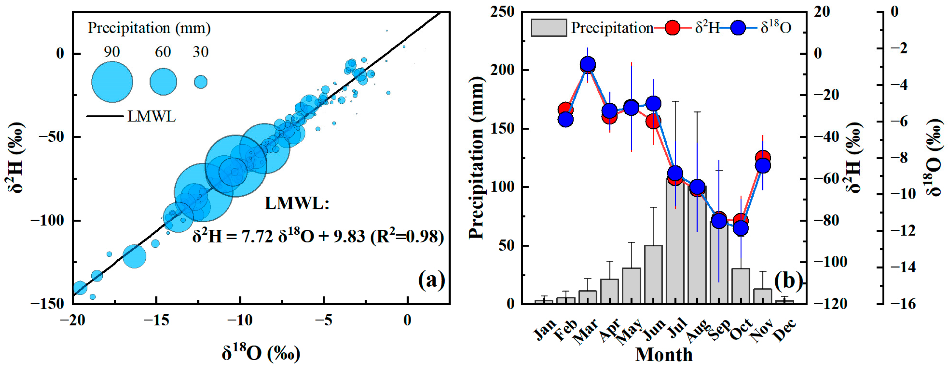
3.1. Stable Isotopes in Precipitation

As shown in Figure 2a, the daily stable isotopic values in precipitation varied widely, ranging from −181.6‰ to 28.2‰ (δ2H) and −23.4‰ to 4.5‰ (δ18O). More negative (i.e., isotopically depleted) values were observed during heavy rainfall events compared to lighter rainfall (Figure 2a and Table 2). The fitted Local Meteoric Water Line (LMWL) was δ2H = 7.72 δ18O + 9.83 (R2 = 0.98) (Figure 2a). The volume-weighted isotopic values showed monthly variations, with enrichment occurring during the dry season and depletion during the rainy season (Figure 2b and Table 2). These variations in precipitation isotopes suggest that the isotopic composition of precipitation, which fluctuates by season and rainfall intensity, can be linked to the isotopic signature of soil water, providing insights into the recharge sources of the latter.

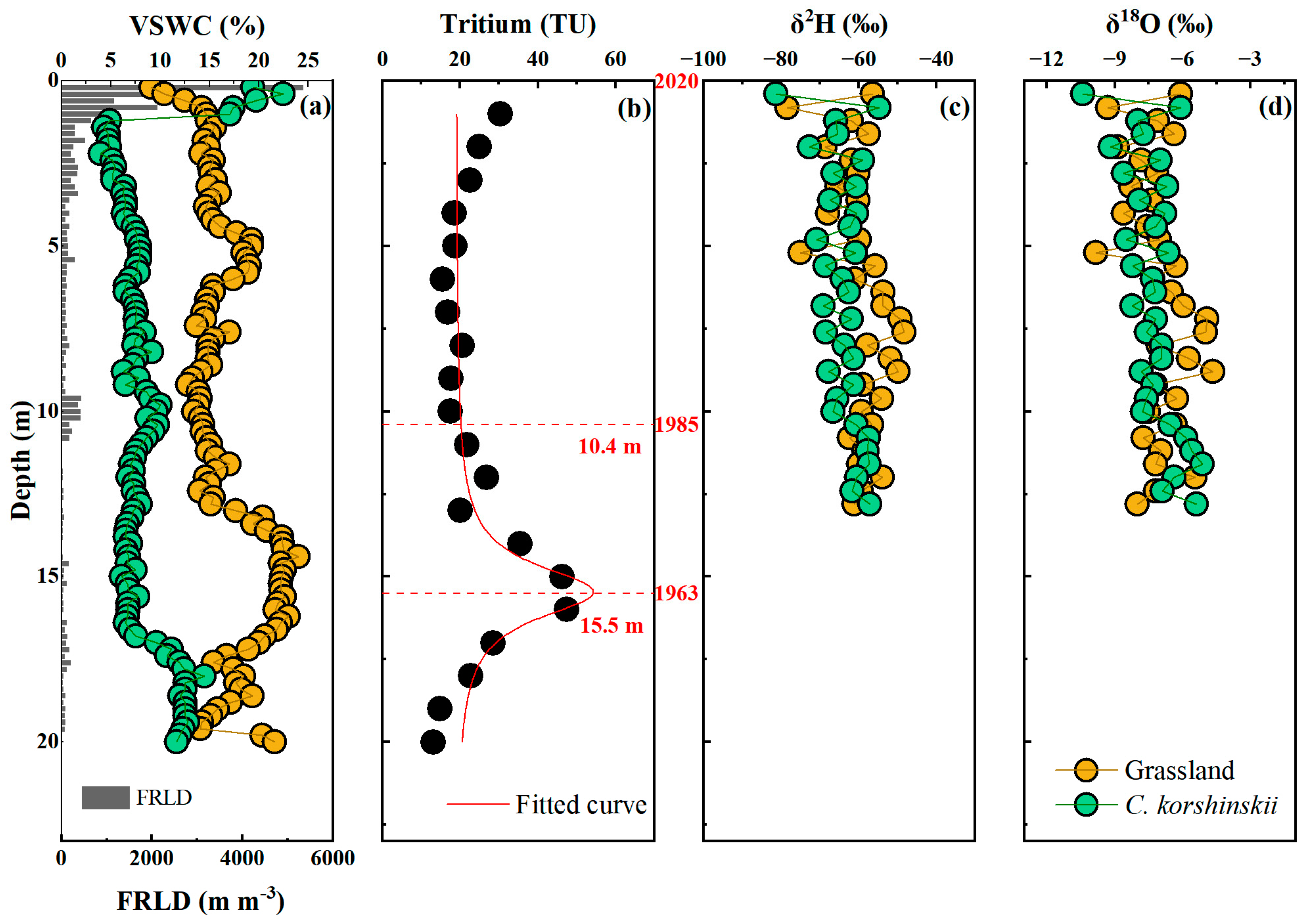
3.2. Root, Soil Water, and Isotopes Profiles

Due to active water movement in the shallow soil layers (0–2 m) and the influence of sampling time, only deep soil water (>2 m) is considered in the following analysis. As shown in Figure 3a, below 2 m, the soil water content in the natural grassland was significantly higher than that in C. korshinskii, with mean values of 17.0 ± 3.0% and 9.0 ± 3.2%, respectively, exhibiting a significant difference (p < 0.01). The root length densities (FRLDs) of C. korshinskii were not zero across a wide range of soil depths (Figure 3), indicating the plant’s adaptation to develop a deep root system capable of extracting water from the 0–22 m soil depth range. Overall, deep-rooted vegetation was found to deplete additional water stored in the deeper soil layers.
The tritium profile displayed a bell-shaped distribution, with peak values detected at approximately 15.5 m (Figure 3b), suggesting the infiltration depth of rainfall from 1963. The unimodal curve indicates the presence of piston flow within the study area. Using the peak tritium depth, we calculated the rainfall infiltration rate after vegetation establishment and determined the potential depth influenced by land use changes, which was found to be 10.4 m (Figure 3b). Therefore, the water isotopes in the 2–10.4 m soil layer were selected to represent the robust hydrological information following land use changes.
The δ2H and δ18O values between 2 and 10.4 m varied with land use types (Figure 3c,d). The δ2H (δ18O) values in the 2–10.4 m soil layer for native grassland and C. korshinskii were −58.3 ± 6.3‰ (−6.9 ± 1.2‰) and −64.3 ± 3.4‰ (−7.4 ± 0.6‰), respectively. The soil water isotopes were more enriched under the native grassland compared to the C. korshinski land.

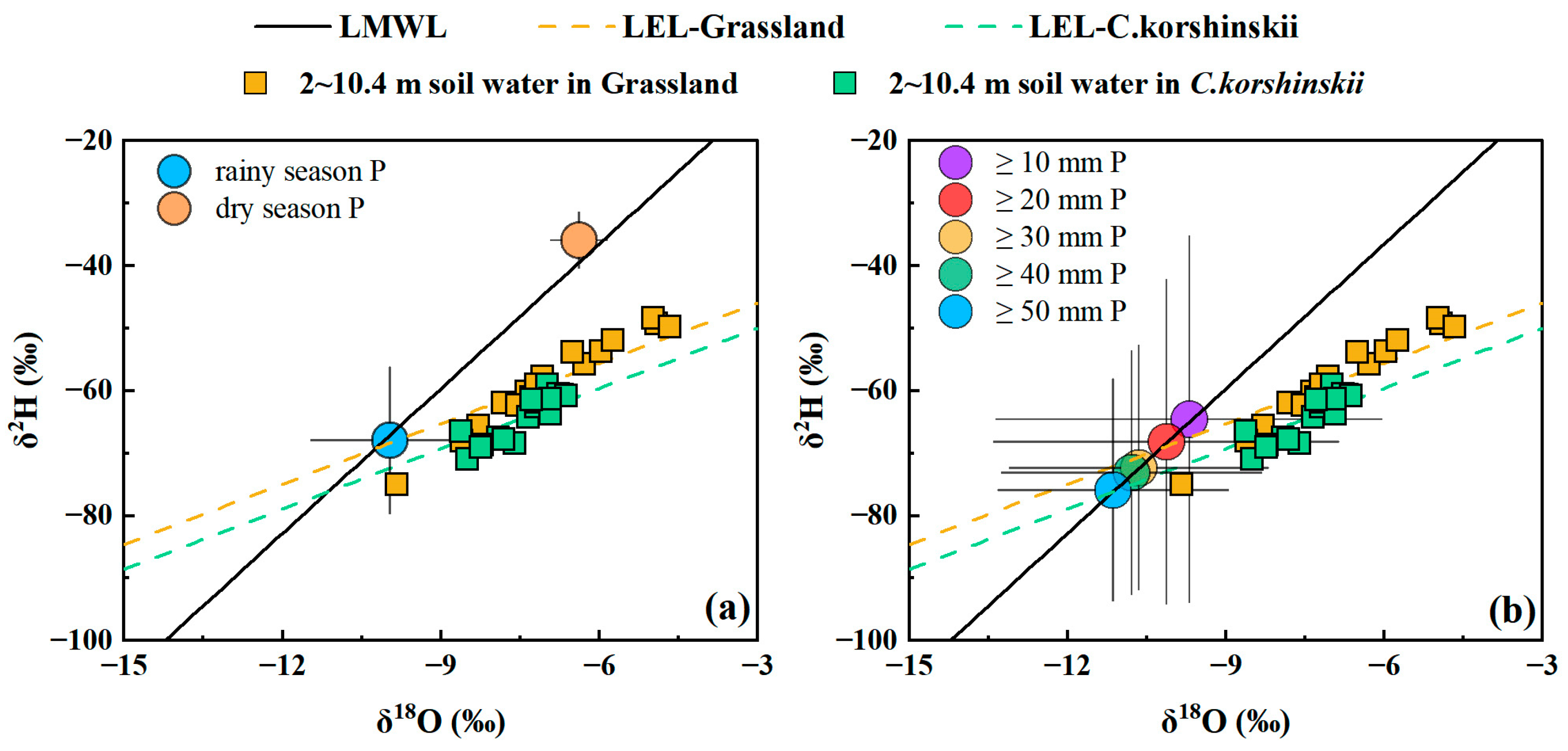
3.3. Deep Soil Water Sources and Deep Drainage

To account for the effects of evaporation and accurately determine the isotopic composition of initial water sources, we applied a correction along the local soil water evaporation line (LEL) to its intersection with the local meteoric water line (LMWL) (Figure 4; Table 3). The corrected isotopic values of soil water sources at depths of 2–10.4 m in natural grassland were δ2H = −69.3‰ and δ18O = −10.2‰. In comparison, soil water sources in the same depth range under C. korshinskii exhibited more isotopically depleted values (δ2H = −76.2‰ and δ18O = −11.1‰), reflecting differences in recharge dynamics between land use types.
To identify the sources of soil water recharge, we compared the isotopic compositions of soil water sources with seasonal precipitation. The isotopic signatures of soil water sources at depths of 2–10.4 m in both natural grassland and C. korshinskii land were closely aligned with those of rainy season precipitation, whereas they deviated significantly from dry season precipitation (Figure 4a). This indicates that soil water recharge under both vegetation types is primarily derived from rainy season precipitation. A further comparison with precipitation isotopes across rainfall intensities revealed distinct recharge thresholds. Soil water under natural grassland was replenished by precipitation events with intensities ≥ 20 mm, while the threshold for C. korshinskii land was notably higher, at ≥50 mm (Figure 4b). These findings suggest that the introduction of C. korshinskii increased the rainfall requirement for deep soil layer recharge compared to native grassland.
The estimated deep drainage (D) under different vegetation types is summarized in Table 4. Since the establishment of C. korshinskii in 1985, soil water storage (SWS) has decreased by 46.4 mm yr−1 compared to native grassland. Under natural grassland, deep drainage was estimated at 39.6 mm yr−1. However, for C. korshinskii, the deep drainage value fell below zero (−6.8 mm yr−1), indicating the cessation of potential groundwater recharge beneath C. korshinskii. This highlights the impact of vegetation change on hydrological processes and groundwater recharge in the study area.

4. Discussion

4.1. Insights from the Joint Use of Stable and Radioactive Water Isotopes

The bell-shaped tritium profile recorded in this study effectively illustrates the piston flow recharge process, thereby validating the use of tritium to trace soil water sources (Figure 4). Piston flow has been well established as the dominant mechanism for soil water movement in loess regions, as corroborated by multiple studies [24,25]. The tritium profile also provides critical insights into the timing of recharge events, particularly revealing that soil water at depths above 10.2 m originated from precipitation that occurred after the planting of vegetation (Figure 4). This further emphasizes the utility of tritium-based techniques for quantifying infiltration rates and determining the age of soil water, which have been widely applied in the Loess Plateau [22,35]. These results support the hypothesis that soil water above 10.2 m reflects the cumulative impacts of land use changes.
In comparing the isotopic signatures of soil water with those of precipitation, we observed that the isotopic compositions of soil water under both vegetation covers were closer to those of precipitation during the rainy season (Figure 4a). This finding is consistent with prior research [26,36] and is not unexpected given the region’s monsoon climate, where more than 60% of annual precipitation occurs during the rainy season. The dry season is characterized by smaller, sporadic precipitation events, most of which quickly evaporate [37]. Moreover, during the dry season, potential evapotranspiration typically exceeds or equals the precipitation amount, with soil moisture surplus predominantly available during the rainy season [11]. This makes it clear that, under such climatic conditions, only precipitation from the rainy season can effectively recharge the soil, particularly in deeper soil layers. Our isotope-based findings align with continuous soil water observations [38] and modeling studies [39,40], reinforcing the critical role of heavy rainfall during the rainy season in replenishing deep soil moisture.

4.2. Effect of Deep-Rooted Vegetation on Deep Soil Water Recharge

Our results indicate that moderate rainfall events (≥20 mm) are sufficient to recharge deep soil water (2–10.4 m) under native grassland conditions. However, in areas dominated by C. korshinskii, only high-intensity rainfall events (≥50 mm) can effectively recharge deep soil water (Figure 4b). C. korshinskii, a deep-rooted species to the Loess Plateau, is known to significantly deplete deep soil water, exacerbating soil desiccation as the stand matures. Our findings show that the root system of C. korshinskii extends to depths of at least 22 m, leading to a considerable depletion of soil water storage (Figure 3).
Under conditions of low initial soil moisture, heavy precipitation events are necessary to establish connectivity within the soil’s pore water, facilitating effective recharge [41,42]. This creates a scenario in which deeper-rooted vegetation, such as C. korshinskii, demands more intense rainfall to replenish deep soil water layers. Additionally, the dense canopies of shrubs like C. korshinskii exert a significant interception effect on rainfall [43], further limiting the amount of water that can penetrate the soil. This interception effect, coupled with the higher transpiration rates of deep-rooted vegetation compared to native grasslands [44], means that even when some rainfall events manage to replenish the soil, the water is quickly absorbed by the roots. Consequently, more intense rainfall events are required to maintain adequate soil moisture. This shift in the hydrological balance underscores how the establishment of deep-rooted vegetation can significantly increase the threshold for deep soil water recharge, altering the dynamics of the soil–water–plant system.

4.3. Implications for Water and Land Resource Management

Land use changes, particularly the establishment of deep-rooted vegetation, have profound impacts on the terrestrial water cycle, influencing both deep soil water and groundwater recharge [24,36]. In this study, we found that deep-rooted vegetation can inhibit the replenishment of deep soil water, thus disrupting groundwater recharge (Table 4). This finding underscores the importance of considering the hydrological consequences of land use changes, especially in regions with significant vegetation transitions.
Our isotopic evidence indicates that deep-rooted vegetation can only recharge deep soil water during high-intensity rainfall events (>50 mm). While this may initially raise concerns due to the relatively infrequent occurrence of such heavy rainfall events, recent trends suggest an increase in the frequency of extreme rainfall events in the region, likely driven by climate change [45]. Such changes in precipitation patterns could influence the recovery of multi-year dry soil layers [46], potentially altering the dynamics of deep soil water recharge. Moreover, anticipated changes in atmospheric circulation may lead to a warmer and more humid climate in the region [47,48]; it may be possible to achieve sustainable management of vadose zone water resources through appropriate vegetation management practices, such as thinning and pruning, rather than completely dismantling established forests [49,50].
Furthermore, the integration of stable and radioactive water isotopes provides valuable insights into the processes of deep soil water recharge. These isotopes could play a critical role in optimizing hydrological models [16,51], especially in regions affected by land use changes. Hydrological models typically require parameters that are difficult to measure directly, such as soil hydraulic properties, root distribution, extinction coefficients, and crop coefficients. By incorporating isotope-based estimates, these parameters can be optimized, improving model accuracy and enhancing predictions of hydrological dynamics in response to land use changes.

5. Conclusions

This study integrates stable and radioactive water isotopes to qualitatively assess the sources of deep soil water recharge and evaluate the impact of vegetation changes. Both natural grassland and C. korshinskii plots primarily rely on rainfall during the rainy season for deep soil water replenishment. However, the establishment of C. korshinskii has increased the rainfall threshold for deep soil water recharge from 20 mm to 50 mm. The conversion of natural grassland to C. korshinskii has led to a reduction in soil water storage and deep drainage. These findings have significant implications for water and land resource management, particularly in regions experiencing substantial vegetation changes.

Author Contributions

Conceptualization, J.J. and J.L.; methodology, X.D.; software, X.D.; validation, J.J., F.L. and Z.J.; formal analysis, J.J.; investigation, J.J.; resources, J.L.; data curation, M.L.; writing—original draft preparation, J.J.; writing—review and editing, H.W. and M.L; visualization, J.J. and J.L.; supervision, M.L.; project administration, M.L.; funding acquisition, M.L. All authors have read and agreed to the published version of the manuscript.

Funding

This research was funded by the National Key R&D Program of China, grant number 2021YFD1900700, and the National Natural Science Foundation of China, grant number 52479051.

Data Availability Statement

Data are contained within the article.

Acknowledgments

The authors thank the Institute of Water-saving Agriculture in Arid Areas of China, Northwest A&F University, for technical help.

Conflicts of Interest

Author Junchao Li was employed by the Shaanxi Provincial Land Engineering Construction Group Co., Ltd. The remaining authors declare that the research was conducted in the absence of any commercial or financial relationships that could be construed as a potential conflict of interest.

References

  1. Pokhrel, Y.; Felfelani, F.; Satoh, Y.; Boulange, J.; Burek, P.; Gädeke, A.; Gerten, D.; Gosling, S.N.; Grillakis, M.; Gudmundsson, L.; et al. Global Terrestrial Water Storage and Drought Severity under Climate Change. Nat. Clim. Chang. 2021, 11, 226–233. [Google Scholar] [CrossRef]
  2. Adhikari, K.; Hartemink, A.E. Linking Soils to Ecosystem Services—A Global Review. Geoderma 2016, 262, 101–111. [Google Scholar] [CrossRef]
  3. Saccò, M.; Mammola, S.; Altermatt, F.; Alther, R.; Bolpagni, R.; Brancelj, A.; Brankovits, D.; Fišer, C.; Gerovasileiou, V.; Griebler, C.; et al. Groundwater Is a Hidden Global Keystone Ecosystem. Glob. Chang. Biol. 2024, 30, e17066. [Google Scholar] [CrossRef] [PubMed]
  4. Wang, Y.; Hu, W.; Sun, H.; Zhao, Y.; Zhang, P.; Li, Z.; Zhou, Z.; Tong, Y.; Liu, S.; Zhou, J.; et al. Soil Moisture Decline in China’s Monsoon Loess Critical Zone: More a Result of Land-Use Conversion than Climate Change. Proc. Natl. Acad. Sci. USA 2024, 121, e2322127121. [Google Scholar] [CrossRef]
  5. Chen, C.; Park, T.; Wang, X.; Piao, S.; Xu, B.; Chaturvedi, R.K.; Fuchs, R.; Brovkin, V.; Ciais, P.; Fensholt, R.; et al. China and India Lead in Greening of the World through Land-Use Management. Nat. Sustain. 2019, 2, 122–129. [Google Scholar] [CrossRef] [PubMed]
  6. Pradhan, S.; Dhar, A.; Tiwari, K.N. On Quantification of Groundwater Dynamics Under Long-Term Land Use Land Cover Transition. Water Resour. Manag. 2022, 36, 4039–4055. [Google Scholar] [CrossRef]
  7. Tang, Z.; Zhou, Z.; Wang, D.; Luo, F.; Bai, J.; Fu, Y. Impact of Vegetation Restoration on Ecosystem Services in the Loess Plateau, a Case Study in the Jinghe Watershed, China. Ecol. Indic. 2022, 142, 109183. [Google Scholar] [CrossRef]
  8. Cui, J.; He, M.; Lian, X.; Wei, Z.; Wang, T. Spatial Pattern of Plant Transpiration Over China Constrained by Observations. Geophys. Res. Lett. 2023, 50, e2023GL105489. [Google Scholar] [CrossRef]
  9. Li, S.; Liang, W.; Fu, B.; Lü, Y.; Fu, S.; Wang, S.; Su, H. Vegetation Changes in Recent Large-Scale Ecological Restoration Projects and Subsequent Impact on Water Resources in China’s Loess Plateau. Sci. Total Environ. 2016, 569–570, 1032–1039. [Google Scholar] [CrossRef] [PubMed]
  10. Li, H.; Si, B.C.; Zhang, Z.; Miao, C. Deep Soil Water Storage and Drainage Following Conversion of Deep Rooted to Shallow Rooted Vegetation. Agr. Water Manag. 2022, 261, 107359. [Google Scholar] [CrossRef]
  11. Li, H.; Ma, X.; Lu, Y.; Ren, R.; Cui, B.; Si, B. Growing Deep Roots Has Opposing Impacts on the Transpiration of Apple Trees Planted in Subhumid Loess Region. Agric. Water Manag. 2021, 258, 107207. [Google Scholar] [CrossRef]
  12. Yang, M.; Gao, X.; Wang, S.; Zhang, X.; Cai, Y.; Song, X.; Siddique, K.H.M.; Zhao, X. Photosynthetic Response to Deep Soil Water Deficit in a Semiarid Apple Tree Plantation. J. Hydrol. 2023, 617, 129161. [Google Scholar] [CrossRef]
  13. Shao, X.; Gao, X.; Zeng, Y.; Yang, M.; Wang, Y.; Zhao, X. Eco-Physiological Constraints of Deep Soil Desiccation in Semiarid Tree Plantations. Water Resour. Res. 2023, 59, e2022WR034246. [Google Scholar] [CrossRef]
  14. Lu, Y.; Biswas, A.; Wen, M.; Si, B. Predicting Bulk Density in Deep Unsaturated Soils Based on Multiple Scale Decomposition. Geoderma 2021, 385, 114859. [Google Scholar] [CrossRef]
  15. Gardiya Weligamage, H.; Fowler, K.; Peterson, T.J.; Saft, M.; Peel, M.C.; Ryu, D. Partitioning of Precipitation into Terrestrial Water Balance Components Under a Drying Climate. Water Resour. Res. 2023, 59, e2022WR033538. [Google Scholar] [CrossRef]
  16. Sun, J.; Wang, J.; Li, Z. Partitioning Soil Water Balance under Deep-Rooted Fruit Trees in the Thick Loess Deposits. Catena 2024, 244, 108261. [Google Scholar] [CrossRef]
  17. Scandellari, F.; Attou, T.; Barbeta, A.; Bernhard, F.; D’Amato, C.; Dimitrova-Petrova, K.; Donaldson, A.; Durodola, O.; Ferraris, S.; Floriancic, M.G.; et al. Using Stable Isotopes to Inform Water Resource Management in Forested and Agricultural Ecosystems. J. Environ. Manag. 2024, 365, 121381. [Google Scholar] [CrossRef] [PubMed]
  18. Wei, H.; Wang, J.; Li, M.; Wen, M.; Lu, Y. Assessing the Applicability of Mainstream Global Isoscapes for Predicting δ18O, δ2H, and d-Excess in Precipitation across China. Water 2023, 15, 3181. [Google Scholar] [CrossRef]
  19. Al-Oqaili, F.; Good, S.P.; Peters, R.T.; Finkenbiner, C.; Sarwar, A. Using Stable Water Isotopes to Assess the Influence of Irrigation Structural Configurations on Evaporation Losses in Semiarid Agricultural Systems. Agric. For. Meteorol. 2020, 291, 108083. [Google Scholar] [CrossRef]
  20. Wei, H.; Lu, Y.; Bai, L.; Niu, J.; Chen, S.; Mojid, M.A.; Yang, Y.; Li, M. Water Uptake Characteristics of Stipa Bungeana Trin: Affected by Subsidence in the Coal Mining Areas of Northwest China. Agronomy 2024, 14, 424. [Google Scholar] [CrossRef]
  21. Aron, P.G.; Levin, N.E.; Beverly, E.J.; Huth, T.E.; Passey, B.H.; Pelletier, E.M.; Poulsen, C.J.; Winkelstern, I.Z.; Yarian, D.A. Triple Oxygen Isotopes in the Water Cycle. Chem. Geol. 2021, 565, 120026. [Google Scholar] [CrossRef]
  22. Chen, G.; Wu, W.; Meng, T.; Wen, M.; Si, B.; He, J.; Li, M.; Dong, Q.; Feng, H.; Siddique, K.H.M. Quantitative Partitioning of Temporal Origin of Transpiration into Pre- and Post-Plantation under Deep-Rooted Vegetation on the Loess Plateau of China. J. Hydrol. 2023, 617, 128964. [Google Scholar] [CrossRef]
  23. Huang, Y.; Evaristo, J.; Li, Z.; Chun, K.P.; Sutanudjaja, E.H.; Cardenas, M.B.; Bierkens, M.F.P.; Kirchner, J.W.; Van Genuchten, M.T. The Nature and Extent of Bomb Tritium Remaining in Deep Vadose Zone: A Synthesis and Prognosis. Vadose Zone J. 2024, 23, e20304. [Google Scholar] [CrossRef]
  24. Ji, W.; Huang, Y.; Shi, P.; Li, Z. Recharge Mechanism of Deep Soil Water and the Response to Land Use Change in the Loess Deposits. J. Hydrol. 2021, 592, 125817. [Google Scholar] [CrossRef]
  25. Shi, P.; Huang, Y.; Yang, C.; Li, Z. Quantitative Estimation of Groundwater Recharge in the Thick Loess Deposits Using Multiple Environmental Tracers and Methods. J. Hydrol. 2021, 603, 126895. [Google Scholar] [CrossRef]
  26. Xiang, W.; Evaristo, J.; Li, Z. Recharge Mechanisms of Deep Soil Water Revealed by Water Isotopes in Deep Loess Deposits. Geoderma 2020, 369, 114321. [Google Scholar] [CrossRef]
  27. Skrzypek, G.; Mydłowski, A.; Dogramaci, S.; Hedley, P.; Gibson, J.J.; Grierson, P.F. Estimation of Evaporative Loss Based on the Stable Isotope Composition of Water Using Hydrocalculator. J. Hydrol. 2015, 523, 781–789. [Google Scholar] [CrossRef]
  28. Xiang, W.; Si, B.; Li, M.; Li, H.; Lu, Y.; Zhao, M.; Feng, H. Stable Isotopes of Deep Soil Water Retain Long-Term Evaporation Loss on China’s Loess Plateau. Sci. Total Environ. 2021, 784, 147153. [Google Scholar] [CrossRef] [PubMed]
  29. Benettin, P.; Volkmann, T.H.M.; von Freyberg, J.; Frentress, J.; Penna, D.; Dawson, T.E.; Kirchner, J.W. Effects of Climatic Seasonality on the Isotopic Composition of Evaporating Soil Waters. Hydrol. Earth Syst. Sci. 2018, 22, 2881–2890. [Google Scholar] [CrossRef]
  30. Horita, J.; Wesolowski, D.J. Liquid-Vapor Fractionation of Oxygen and Hydrogen Isotopes of Water from the Freezing to the Critical Temperature. Geochim. Cosmochim. Acta 1994, 58, 3425–3437. [Google Scholar] [CrossRef]
  31. Gibson, J.J.; Reid, R. Water Balance along a Chain of Tundra Lakes: A 20-Year Isotopic Perspective. J. Hydrol. 2014, 519, 2148–2164. [Google Scholar] [CrossRef]
  32. Zhang, Z.; Li, M.; Si, B.; Feng, H. Deep Rooted Apple Trees Decrease Groundwater Recharge in the Highland Region of the Loess Plateau, China. Sci. Total Environ. 2018, 622–623, 584–593. [Google Scholar] [CrossRef] [PubMed]
  33. Phillips, F.M. Environmental Tracers for Water Movement in Desert Soils of the American Southwest. Soil. Sci. Soc. Am. J. 1994, 58, 15–24. [Google Scholar] [CrossRef]
  34. Si, B.C.; de Jong, E. Determining Long-Term (Decadal) Deep Drainage Rate Using Multiple Tracers. J. Environ. Qual. 2007, 36, 1686–1694. [Google Scholar] [CrossRef]
  35. Li, H.; Si, B.; Li, M. Rooting Depth Controls Potential Groundwater Recharge on Hillslopes. J. Hydrol. 2018, 564, 164–174. [Google Scholar] [CrossRef]
  36. Shi, P.; Huang, Y.; Ji, W.; Xiang, W.; Evaristo, J.; Li, Z. Impacts of Deep-Rooted Fruit Trees on Recharge of Deep Soil Water Using Stable and Radioactive Isotopes. Agr. For. Meteorol. 2021, 300, 108325. [Google Scholar] [CrossRef]
  37. Zhu, P.; Zhang, G.; Wang, H.; Zhang, B.; Liu, Y. Soil Moisture Variations in Response to Precipitation Properties and Plant Communities on Steep Gully Slope on the Loess Plateau. Agric. Water Manag. 2021, 256, 107086. [Google Scholar] [CrossRef]
  38. Jin, Z.; Guo, L.; Lin, H.; Wang, Y.; Yu, Y.; Chu, G.; Zhang, J. Soil Moisture Response to Rainfall on the Chinese Loess Plateau after a Long-Term Vegetation Rehabilitation. Hydrol. Process 2018, 32, 1738–1754. [Google Scholar] [CrossRef]
  39. Bai, X.; Jia, X.; Jia, Y.; Shao, M.; Hu, W. Modeling Long-Term Soil Water Dynamics in Response to Land-Use Change in a Semi-Arid Area. J. Hydrol. 2020, 585, 124824. [Google Scholar] [CrossRef]
  40. Shao, M.; Wang, Y.; Xia, Y.; Jia, X. Soil Drought and Water Carrying Capacity for Vegetation in the Critical Zone of the Loess Plateau: A Review. Vadose Zone J. 2018, 17, 170077. [Google Scholar] [CrossRef]
  41. Mei, X.; Ma, L. Effect of Afforestation on Soil Water Dynamics and Water Uptake under Different Rainfall Types on the Loess Hillslope. Catena 2022, 213, 106216. [Google Scholar] [CrossRef]
  42. Wiekenkamp, I.; Huisman, J.A.; Bogena, H.R.; Lin, H.S.; Vereecken, H. Spatial and Temporal Occurrence of Preferential Flow in a Forested Headwater Catchment. J. Hydrol. 2016, 534, 139–149. [Google Scholar] [CrossRef]
  43. Niu, X.; Fan, J.; Du, M.; Dai, Z.; Luo, R.; Yuan, H.; Zhang, S. Changes of Rainfall Partitioning and Canopy Interception Modeling after Progressive Thinning in Two Shrub Plantations on the Chinese Loess Plateau. J. Hydrol. 2023, 619, 129299. [Google Scholar] [CrossRef]
  44. Jia, T.; Liu, T.; Bao, Y.; Duan, L.; Tong, X.; Zhang, Y.; Lun, S.; Zhang, S.; Shamseldin, A.Y.; Latu, K.; et al. Responses and Driving Force Analysis of Typical Arbor and Shrub Sap Flow to Patterns of Rainfall in Semi-Arid Areas. Ecol. Indic. 2024, 168, 112803. [Google Scholar] [CrossRef]
  45. Wang, L.; Gu, X.; Slater, L.J.; Lai, Y.; Zheng, Y.; Gong, J.; Dembélé, M.; Tosunoğlu, F.; Liu, J.; Zhang, X.; et al. Attribution of the Record-Breaking Extreme Precipitation Events in July 2021 Over Central and Eastern China to Anthropogenic Climate Change. Earth’s Futur. 2023, 11, e2023EF003613. [Google Scholar] [CrossRef]
  46. Zhu, X.; Miao, P.; Zhu, H.; Li, W.; Liang, X.; Wang, L.; Chen, Z.; Zhou, J. Extreme Precipitation Accelerates Nitrate Leaching in the Intensive Agricultural Region with Thick Unsaturated Zones. Sci. Total Environ. 2024, 918, 170789. [Google Scholar] [CrossRef]
  47. Yang, D.; Yang, Y.; Xia, J. Hydrological Cycle and Water Resources in a Changing World: A Review. Geogr. Sustain. 2021, 2, 115–122. [Google Scholar] [CrossRef]
  48. Zhang, Q.; Yang, J.; Wang, W.; Ma, P.; Lu, G.; Liu, X.; Yu, H.; Fang, F. Climatic Warming and Humidification in the Arid Region of Northwest China: Multi-Scale Characteristics and Impacts on Ecological Vegetation. J. Meteorol. Res. 2020, 35, 113–127. [Google Scholar] [CrossRef]
  49. Gavinet, J.; Ourcival, J.-M.; Limousin, J.-M. Rainfall Exclusion and Thinning Can Alter the Relationships between Forest Functioning and Drought. New Phytol. 2019, 223, 1267–1279. [Google Scholar] [CrossRef] [PubMed]
  50. Wang, T.; Xu, Q.; Zhang, B.; Gao, D.; Zhang, Y.; Ren, R.; Jiang, J. Effects of Understory Removal and Thinning on Water Uptake Patterns in Pinus Massoniana Lamb. Plantations: Evidence from Stable Isotope Analysis. For. Ecol. Manag. 2022, 503, 119755. [Google Scholar] [CrossRef]
  51. Li, B.; Shi, P.; Li, Z. Partitioning and Controlling Factors of Evapotranspiration: 1. Hydrological Modeling Constrained with Isotope-Based Water Balance Decoupling. Agric. Ecosyst. Environ. 2024, 364, 108908. [Google Scholar] [CrossRef]
Figure 1. Location of the study site on the Chinese Loess Plateau (a), distribution of sampling locations (b).
Water 17 00208 g001
Figure 2. Isotope values of δ18O plotted against δ2H in precipitation (a) and seasonal variation of δ18O and δ2H (b).
Water 17 00208 g002
Figure 3. Vertical distribution of soil water content (SWC) and root length density (FRLD) (a), tritium (b), δ2H (c), and δ18O (d) within the soil profile.
Water 17 00208 g003
Figure 4. Stable isotopic compositions of soil water and its sources in different season (a) and precipitation intensity (b). GMWL and LMWL, respectively, represent the global meteoric water line (δ2H = 8δ18O + 10) and the local meteoric water line (δ2H = 7.72 δ18O + 9.83). LEL represents the local soil water evaporation line.
Water 17 00208 g004
Table 1. Detailed information about the sampling locations.
VegetationGradient (°)LatitudeLongitudeAltitudeStand Age (Years)
Grassland3237°31′16″ N110°17′05″ E980Long-term
C. korshinskii3237°31′16″ N110°17′05″ E98036
Table 2. Amount-weighted mean values of stable isotopes in precipitation of different seasons and intensities.
δ2H (‰)δ18O (‰)Proportion of Amount (%)
All precipitation−59.7 ± 10.4−9.0 ±1.2100.0 ± 0.0
Rainy season precipitation−68.0 ± 11.7−10.0 ±1.564.9 ± 8.1
Dry season precipitation−35.9 ± 4.4−6.4 ± 0.535.2 ± 8.1
Precipitation ≥ 10 mm−64.6 ± 29.3−9.7 ± 3.672.4 ± 12.8
Precipitation ≥ 20 mm−68.2 ± 25.9−10.1 ± 3.348.5 ± 15.5
Precipitation ≥ 30 mm−72.3 ± 19.5−10.7 ± 2.436.0 ± 12.1
Precipitation ≥ 40 mm−73.1 ± 19.4−10.8 ± 2.531.1 ± 11.0
Precipitation ≥ 50 mm−75.9 ± 17.7−11.1 ± 2.219.9 ± 8.4
Table 3. Soil evaporation lines (SLEL) and stable isotopic composition of soil water sources under different land use types.
VegetationSLELInterceptR2Soil Water Source δ2H (‰)Soil Water Source δ18O (‰)
Grassland3.22−36.290.84−69.3−10.2
C. korshinskii3.22−40.300.67−76.2−11.1
Table 4. The estimated deep drainage under different land use types.
VegetationP
(mm yr−1)
ΔS
(mm yr−1)
D
(mm yr−1)
Grassland444.4039.6
C. korshinskii444.446.4−6.8
Note: P, ΔS, D represent mean annual precipitation, variation in soil water storage, and deep drainage, respectively.
Disclaimer/Publisher’s Note: The statements, opinions and data contained in all publications are solely those of the individual author(s) and contributor(s) and not of MDPI and/or the editor(s). MDPI and/or the editor(s) disclaim responsibility for any injury to people or property resulting from any ideas, methods, instructions or products referred to in the content.

