Abstract
This study presents a methodology for extracting precise insights on sediment transport in the minor bed of a watercourse using MIKE 21 hydrodynamic modelling software. By integrating geotechnical, geomorphological, and hydrological datasets with a good-resolution Digital Terrain Model (DTM), sediment quantities along a 4.9 km stretch of the Șolea stream—spanning from its source to its confluence with the Vâlsan River (Argeș hydrographic basin)—were determined. A three-month simulation using MIKE 21’s “Mud Transport Module” enabled the comparison of pre- and post-simulation terrain models, yielding detailed information on sediment distribution across the riverbed. These results offer predictive capabilities regarding erosional dynamics and inform mitigation measures to address sedimentary erosion within the study area. The study also presents proposals for land reclamation necessary to prevent the degradation of the riverbed and slopes, such as gabion retaining walls and check dams in the riverbed.
1. Introduction
Mathematical modelling hinges on selecting equations that adequately represent the physical system. While such models are invaluable, they inherently involve uncertainties—particularly in the input hydrological data. As noted by [1], early identification of uncertainty sources is essential to reduce ambiguity in outcomes.
Internationally, mathematical modelling using Mike 21 software is very common in various studies, including the following works: Estuarine Inundation Modelling Using the Mike 21 Hydrodynamic Model (Rita Brás da Fonseca, Portugal, 2015), Mike 21 in Urban Flood Risk Analysis (Alexander Salmonsson, Stockholm, Sweden, 2015), Analysis of Water Quality Improvement in Urban Streams Using MIKE 21 FM (Dongwoo Jang, Republic of Korea, 2021), 1D−2D hydrodynamic and sediment transport modelling using Mike models (Kuldeep Pareta, India, 2024).
Numerical modelling in hydraulic engineering seeks to uphold two fundamental principles:
- “To treat uncertainty as the only known aspect of the future reflects intellectual courage and confidence” [2].
- “Water is the most unforgiving judge in verifying hydraulic structures—it tolerates no error in design, execution, or operation” [3].
The two principles above [2,3], we consider basic in the approach to mathematical modelling both from a philosophical [2] and a practical engineering [3] point of view in the applicability of water resources management. We have resorted to the two quotes, because water is and will remain an important geostrategic source regardless of its location on the globe, which is why mathematical modelling can play an important role in the predictability of the rapid evolution of meteorological phenomena, being a forecast stabilizing point, which helps water specialists and decision-makers on a good management of water resources, like a GPS (global positioning system) to counteract the negative effects that climate change can produce. If we analyze the climate changes of recent years, the association of strategic thinking on water simultaneously with the technical and engineering measures necessary to prevent financial and human damage, we can say that thinking strategically in this field can be considered the ability to think about the unthinkable.
We can conclude that mathematical modelling plays the role of the “soldier” in the following quote, “water shapes its course according to the nature of the ground over which it flows the soldier works out his victory in relation to the foe whom he is facing” (Sun Tzu), where numerical simulations can predict risks and areas with high risk potential, against which the necessary measures can be taken to counteract the negative effects brought to the protection of the environment and human lives. The aim of the study is to highlight the benefits of mathematical modelling using Mike 21 software by calculating sediment transport and identifying erosion and deposition areas in the riverbed, in order to determine what hydraulic engineering works are necessary for future water environment management and environmental protection to increase the sustainability of nature conservation.
2. Materials and Methods
Study Area
The study focuses on central Romania, in Argeș County, within the jurisdiction of the Argeș-Vedea Vedea River Basin Administration.
The study area encompasses the minor riverbed of the Șolea stream in Brăduleț commune, located in the Subcarpathian region of northern Argeș County (Figure 1). The Șolea stream is unmanaged in cadastral records and administered locally, prompting a commissioned hydrological study from the National Institute of Hydrology and Water Management [4] to assess long-term average flow.
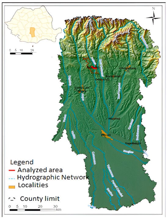
Figure 1.
Geographical location of the studied area.
The Șolea is a right-bank tributary of the Vâlsan River (cadastral code X-1.14),, stretching 4.9 km with a basin slope of 12.8% and a total catchment area of 6.82 km2. Originating from torrents at 1216 m elevation, it traverses west to east through Brăduleț and joins the Vâlsan at 590 m altitude (Figure 2).
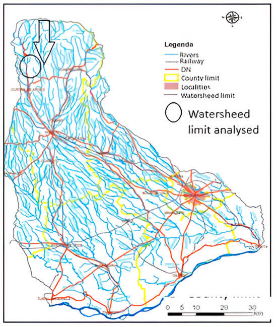
Figure 2.
Surface Area of the Argeș Vedea Watershed.
MIKE 21 hydrodynamic modelling software (developed by the Danish Hydraulic Institute from Denmark) employs finite element mesh-based modelling for various hydrological scenarios—from urban flooding to sediment transport and coastal dynamics. Its framework is grounded in the Navier–Stokes equations, incorporating mass continuity, momentum, temperature, salinity, density variations, and turbulence.
Model discretization uses the finite volume method within triangular or quadrilateral grids. Core equations include: The working domain is divided into adjacent cells/elements that can be either triangles or quadrilaterals. Core equations include:
- -
- The continuity Equation (1)
- -
- The momentum Equations (x and y directions) are described in Equations (2) and (3)
Variables include time (t), Cartesian coordinates (x, y, z), water surface elevation (η), depth (d), velocities (u, v, w), Coriolis parameter (f), gravity (g), densities (ρ, ρ), discharge magnitude (S), and point-source velocities (us, vs).
Two-dimensional (2D) hydrodynamic models are essential tools for simulating spatial variations in hydraulic conditions both longitudinally (along the river) and laterally (across the river width), relying on average vertical velocity values to characterize flow behavior [5,6].
2D models offer a nuanced depiction of transverse variations in water surface elevation and flow velocity at average depths. Despite their computational intensity, they remain applicable across broad sectors of hydrographic networks and are increasingly favoured for their ability to simulate unsteady, multidirectional flows—especially in flood-prone or morphologically complex regions (Hunter & Bates, 2002; Horritt et al., 2010; Miremad et al., 2025) [7,8,9].
Among natural hazards, floods stand out due to their frequency, scale, and destructive potential. When conditions align—such as intense rainfall, rapid snowmelt, low soil infiltration, deforestation, and riverbed obstructions—floods can escalate dramatically. These events often exceed the confines of the main channel, inundating extensive riparian zones and causing widespread damage to infrastructure, agriculture, and human settlements [10,11].
The socio-economic repercussions include displacement, loss of livelihoods, and long-term psychological trauma, especially in vulnerable communities.
Regarding sediment transport, a wide array of formulations has been developed and refined in the specialized literature to quantify sediment dynamics in fluvial, coastal, and lacustrine environments [12]. These formulations are essential for predicting erosion, deposition, and morphological evolution under varying hydrodynamic conditions. In practice, several internationally recognized models are integrated into hydrodynamic and sediment transport simulation platforms such as MIKE 21 and MIKE 3, developed by the Danish Hydraulic Institute (DHI), which support both 1D and 2D modelling frameworks for sediment-laden flows [13,14].
The following are among the most widely applied sediment transport models:
- -
- Ref. [13]: An empirically derived model tailored for non-cohesive sediment transport in alluvial channels. It incorporates dimensionless parameters such as sediment mobility and Shields stress and has been updated to improve predictions for fine and coarse sediments [15,16].
- -
- Ref. [14]: A Japanese formulation based on flume experiments, particularly effective for bedload transport in steep mountain streams. It accounts for gravitational effects and slope-induced sediment mobilization.
- -
- Ref. [15]: A physically based model that distinguishes between bedload and suspended load transport, emphasizing the role of stream power and turbulence in sediment entrainment. It is particularly suitable for straight alluvial channels.
- -
- Ref. [16]: The model employed in this study, which presents a total-load transport formulation derived from field and laboratory observations. It assumes uniform sediment and flow conditions and is best suited for sand-dominated systems with low sediment sorting variability.
- -
- Refs. [17,18]: A comprehensive suite of models that separately estimate bedload and suspended load transport. These formulations incorporate critical shear stress, sediment fall velocity, and grain sorting effects, making them applicable to both well-sorted and graded sediment beds [17,18].
In this study, Ref. [16]: model was selected for its simplicity and robustness in simulating total sediment transport under steady flow conditions.
The transport equation is expressed as: , where θ is the total dimensionless tangential effort and ϕ is the dimensionless sediment flux which can also be written as:
In the above equation, qt is the alluvial material transported per unit width, and f is the friction factor defined as , where uf and u are the friction force and the current speed, respectively.
To support the development of the present case study, a comprehensive suite of datasets was utilized to ensure the accuracy and reliability of the sediment transport modelling process. The following categories of data were essential:
- -
- Topographic Data: Provided by the National Administration “Romanian Waters” (NARW), these datasets were acquired through formal written requests and play a foundational role in terrain representation and hydrodynamic simulation.
- -
- Geotechnical Data: Site-specific soil composition and mechanical properties were incorporated to characterize the sediment dynamics and support calibration of the transport equations.
- -
- Hydrological Data: Obtained via hydrological study conducted by the National Institute of Hydrology and Water Management [4] offering crucial parameters such as flow regimes, precipitation patterns, and basin-scale hydrological responses.
- -
- Supplementary Information: Additional data pertaining to administrative boundaries, stream classification, and local observations were integrated to contextualize the modelling framework.
For the construction of the numerical model, the topographic data were processed using the Stereo 70 coordinate system, with S-42 Romania as the geodetic datum. The core dataset consisted of a high-resolution Digital Terrain Model (DTM) with a spatial granularity of 1 × 1 m, compiled from field surveys and elevation measurements conducted under the auspices of the R.W.N.A (Romanian Waters National Administration) in 2020 as part of national hydrographic mapping initiatives.
This digital terrain dataset served as the geometric basis for the simulation environment and allowed for precise delineation of the riverbed morphology, slope variation, and catchment characteristics, facilitating robust application of MIKE 21 software in the subsequent sediment transport analysis.
Flow estimations with varying exceedance probabilities, namely 1% and 5%, were performed utilizing reduction formulas tailored for calculating both the mean multiannual maximum flows and design discharge values, following standard protocols for small basins. These formulas incorporate regionally calibrated hydrological parameters, as outlined in national hydrological syntheses and methodologies for flow regionalization [19,20].
Based on the hydrological study conducted by I.N.H.G.A., the multiannual average flow rate for the Șolea stream was determined to be 0.08 m3/s, serving as the reference discharge for simulation scenarios within the scope of this study.
To ensure accuracy and relevance in the sediment transport modelling, the simulation was conducted under conditions representative of the multiannual average flow, which reflects stable hydrological behaviour over long-term climatic cycles.
Geotechnical Investigation.
Geotechnical characterization (Table 1), of the subsurface in the Brăduleț locality was performed through on-site drilling investigations, executed by Maristar Com [21] and made available free of charge to support this research. These investigations aimed to identify stratigraphic sequences, soil composition, and mechanical properties relevant to sediment mobilization and interaction with hydrodynamic forces.

Table 1.
Geotechnical characterization.
From a geotechnical standpoint, the mechanical and hydrophysical characteristics of these layers—including cohesion, permeability, grain size distribution, and plasticity indices—were compiled and tabulated in Table 2 (soil layers from a geotechnical study), which provides a comprehensive view of the vertical arrangement and engineering behaviour of each stratigraphic unit.

Table 2.
Soil layers from a geotechnical study.
3. Results and Discussions
To simulate water flow and sediment transport processes within the selected study area, a two-dimensional hydraulic model was developed and executed under steady-state conditions. The simulation covered approximately 4.9 km of the Șolea stream, starting upstream of the Brăduleț village and extending to the confluence with the Vâlsan River (Figure 3).
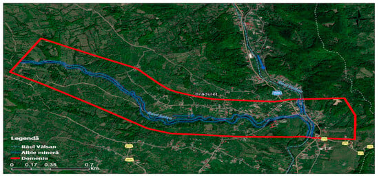
Figure 3.
Area of interest.
To ensure hydraulic continuity and numerical stability at the confluence point, an additional segment of approximately 600 m of the Vâlsan River was incorporated into the modelling domain. This integration supported a realistic boundary condition regime and is illustrated in Figure 4, depicting the modelled intersection between the tributary and the main channel.
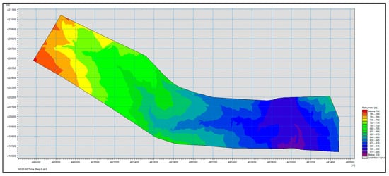
Figure 4.
Processed Digital Terrain Model.
The study area, delineated using topographic maps and high-resolution orthophotographs, comprises an estimated surface of 7.5 km2. The modelled domain includes various hydrological and anthropogenic features—namely the minor bed of the Șolea stream, a segment of the Vâlsan River, infrastructural elements (roads, culverts, and bridges).
Based on the analyzed and vectorized geospatial data, a bathymetric file specific to the MIKE software suite was constructed to define elevation profiles and streambed morphology. This digital input served as the foundational layer for the hydraulic mesh, which was generated using a combination of rectangular and triangular finite elements, customized according to the geometric and hydrodynamic complexity of each subdomain:
- -
- Within the minor riverbed, rectangular mesh elements with dimensions of 9 m in length and 3 m in width were employed to resolve channel geometry and sediment transport dynamics with high fidelity. In transitional or morphologically varied zones, triangular elements with a maximum surface area of 5 m2 were introduced to better conform to terrain irregularities and curvature.
- -
- In contrast, the main riverbed of the Vâlsan River—characterized by smoother flow and less topographic intricacy—was meshed using triangular elements ranging in surface area between 50 m2 and 60 m2, balancing computational efficiency with hydrodynamic resolution.
This adaptive meshing approach ensured a consistent spatial resolution across critical flow pathways while optimizing computational performance. It enabled the accurate representation of bed morphology and sediment transport gradients crucial for downstream erosion and deposition analysis.
Following the processing and integration of all relevant datasets—topographic contours, elevation points, hydrological boundaries, and geospatial overlays—a bathymetry file of type mesh was successfully generated. This file constitutes the core input for hydraulic simulation within the MIKE software framework and represents the most accurate translation of terrain elevations derived from the Digital Terrain Model (DTM).
The construction of the mesh respected the spatial heterogeneity and morphological nuances of the river system, ensuring that geographic features across the computational domain were faithfully represented, from subtle slope gradients to channel curvature and man-made structures. The mesh file captures the vertical relief of the study area, providing a hydrographically coherent and numerically stable foundation for flow and sediment transport modelling.
As illustrated in Figure 4, the final output of the input data preprocessing is displayed, showcasing the structured bathymetric surface that underpins all subsequent hydraulic computations.
Within the “Time” module of the MIKE 21 simulation environment, the temporal framework for the hydraulic and sediment transport analysis is established. For the scope of the present study, the model was configured to operate over a period of three months, capturing seasonal and flow-related variations that may influence sediment behaviour and erosional dynamics.
The simulation was initiated on 1 January 2020, at 12:00 AM and concluded on 1 April 2020, at 12:00 AM. This time interval was selected to encompass a hydrologically active part of the year, typically influenced by winter precipitation, potential thaw events, and early spring runoff conditions—factors that are critical in shaping sediment transport phenomena in small to medium-sized river basins such as the Șolea stream.
The defined temporal scope ensured a comprehensive analysis of both steady-state hydraulic conditions and the cumulative sediment flux over the designated study reach, enhancing the fidelity of the simulation and supporting robust interpretation of the erosional regime during the modelled period.
The Hydrodynamic Module constitutes the core computational engine of the MIKE 21 Flow Model FM system. It serves as the hydrodynamic base for all auxiliary modelling components, including but not limited to the Transport Module, ECO Lab/Oil Spill Module, Mud Transport Module, Sand Transport Module, and the Particle Tracking Module. Each of these modules builds upon the fundamental flow characteristics computed within the hydrodynamic framework to simulate additional physical and environmental processes.
Beyond the finite element mesh network integral to spatial discretization, several key hydraulic parameters were configured in the two-dimensional model to improve representational accuracy and numerical stability:
- -
- Turbulent Viscosity Coefficient:
The simulation employed the Smagorinski formulation, a widely used turbulence model in shallow water hydrodynamics, with a constant coefficient value of 0.28. This approach allows adaptive scaling of turbulent shear effects in regions with high velocity gradients and bathymetric variability [22]
- -
- Roughness Coefficient (Manning’s n):
The roughness coefficient plays a pivotal role in controlling flow resistance and velocity distribution in natural channels. Its value is influenced by:
- -
- The grain size and composition of bed and bank materials,
- -
- The geometric configuration and sinuosity of the riverbed,
- -
- The extent and type of vegetation as well as land use in the floodplain area [22,23].
- -
- For the present study, the domain roughness was treated as spatially uniform, with a Manning coefficient n = 0.039 (equivalent hydraulic radius coefficient M = 25.64). This selection aligns with literature-recommended values for gravel and clay-lined channels with moderate vegetation and reflects the geomorphological characteristics observed in the minor bed of the Șolea stream.
- -
- The determination of this coefficient was informed by published hydraulic engineering standards, visual inspection of terrain via aerial photographs, and direct observation of riparian land cover. These factors provided critical context for interpreting bedform resistance and frictional losses within the simulation framework.
Mud Transport Simulation Configuration To quantify sediment dynamics along the Șolea River channel, the “Mud Transport Module” was integrated into the MIKE 21 simulation workflow. This module is specifically designed to model the transport of cohesive sediments, such as silts and clays, whose behaviour differs markedly from non-cohesive materials due to electrochemical bonding, flocculation, and low settling velocities [23]. The mud transport simulation operates by coupling sediment motion to the hydrodynamic outputs—velocity fields, water depths, and shear stresses—generated by the Flow Module. The Mud Transport Module within the software environment highlights the physical domain and flow-dependent boundary conditions used to drive cohesive sediment dispersion and accumulation patterns.
This section defines the set of physical parameters that govern the sedimentary processes influencing the dynamic behaviour of the riverbed within the modelled domain. These parameters play a vital role in simulating erosion, sediment mobilization, and deposition, particularly when cohesive materials are involved. In the “Bed Parameters” module of the MIKE 21 software, the following variables were configured: Erosion: This parameter refers to the entrainment and upward transfer of sediment particles from the bed layers into the water column. Erosion is initiated when the bed shear stress generated by flowing water exceeds the critical shear stress threshold specific to the sediment type and consolidation level of the stratum. The erosion rate is particularly sensitive to hydrodynamic fluctuations and sediment composition, with finer particles exhibiting lower critical thresholds and higher entrainment potential [24].
- -
- Layer Density: The bulk density of each stratigraphic layer was defined to reflect the degree of sediment compaction and grain-size distribution. This parameter affects both the resistance to erosion and the vertical structure of sediment stratification.
- -
- Bed Roughness: Bed roughness modulates flow velocity gradients at the sediment-water interface. It influences turbulence levels, shear stress, and ultimately the initiation of sediment motion. The roughness coefficient was determined according to particle size, bedform geometry, and material cohesion, calibrated in alignment with MIKE software guidelines and field observations.
The values of the sediment-related coefficients, including erosion rate, critical shear stress, dry density, and bed roughness, were assigned based on recommendations and defaults provided in MIKE documentation, tailored to match the geological and hydrodynamic conditions of the Șolea stream. These are detailed in Table 3, which outlines the parameter values applied to each geotechnical layer within the simulation framework.

Table 3.
Critical shear stresses.
In the MIKE 2024 version, there are 3 types of erosion descriptions available: “Soft mud,” “Hard mud,” and “Mass erosion.”
For density, a constant value was used, differentiated for each defined layer, following the consultation of the specific documentation of the MIKE software, according to Table 4.

Table 4.
Description of Soil Layer Densities.
The bed roughness coefficient plays a critical role in the calculation of internal shear stress within hydraulic models. This parameter encapsulates the resistance encountered by flowing water due to the interaction with sediment particles and the structural features of the riverbed surface. It directly affects the momentum transfer between the water column and the bed interface, influencing both flow velocity gradients and sediment transport dynamics [25].
Bed roughness is primarily governed by two interrelated physical factors:
- -
- Particle Size Distribution: Coarse materials such as gravel or cobbles contribute to higher roughness, while fine particles (e.g., silt or clay) produce lower shear resistance.
- -
- Riverbed Geometry and Microrelief: Channel curvature, bedform structures, and microtopographic variations all shape the hydrodynamic resistance, often becoming the dominant factor where sediment is uniformly fine.
Despite the naturally dynamic nature of microrelief alterations, bed roughness is generally treated as temporally constant in simulation models. This assumption holds when localized morphological changes do not significantly alter the hydraulic behaviour on a domain-wide scale. Thus, variations in bed shape due to small-scale sediment displacement are considered negligible over the modelling period.
Importantly, bed roughness is independent of other sediment parameters such as density, cohesion, or critical shear stress. For cohesive materials, especially fine sediments such as clay and silty clay, the geometrical configuration of the channel becomes the dominant contributor to roughness effects. In alignment with MIKE 21 documentation and sediment modelling best practices, a recommended roughness value of 0.001 m was adopted for fine-sediment conditions in this study.
Following the completion of the simulation scenario using the MIKE 21 modelling framework, spatially explicit data were obtained regarding the distribution and displacement of sediments across the surface of the riverbed within the defined study area. The simulation, conducted over a three-month period—from 1 January 2020, at 12:00 AM to 1 April 2020, at 12:00 AM—yielded valuable insights into the erosional and depositional behaviour of the Șolea stream under steady-flow conditions representative of multiannual averages.
The resulting sediment transport patterns illustrate areas of active erosion, localized accumulation, and migratory shifts within the channel bed, allowing for a quantitative and visual assessment of sediment dynamics across the 4.90 km river stretch. These outcomes support the broader interpretation of morphological evolution and sediment flux intensity within the basin.
The simulation output, processed and rendered in raster format, is illustrated in Figure 5, show casing the sediment distribution and riverbed alteration during the modelled interval.
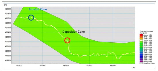
Figure 5.
Erosion Zone and Deposition Zone.
Upon completion of the sediment transport simulation using the MIKE 21 modelling environment, a raster output file was generated that depicts the spatial distribution of sediment accumulation and erosional zones along the Șolea streambed. This raster reflects the morphological evolution of the channel over the defined three-month simulation period and captures both vertical and horizontal bed deformation induced by hydrodynamic forces.
By leveraging MIKE 21′s post-processing capabilities, a modified digital terrain model (DTM) was constructed. This updated DTM (Figure 6) incorporates sediment redistribution data, allowing for a direct comparison with the initial terrain configuration and revealing quantitative transformations across the riverbed surface.
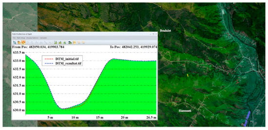
Figure 6.
Sedimentary dynamics.
To further interpret sediment dynamics, a series of cross-sectional profiles were extracted at strategic locations along the minor bed of the Șolea stream. These profiles visualize the overlay of pre-simulation bathymetry (red line) and the post-simulation terrain model (blue line), thereby highlighting zones of net erosion, sediment deposition, and relative stability.
The imagery presented below demonstrates how terrain morphology influences local sediment trends, with variations in channel slope, curvature, and bed composition governing the intensity and direction of sediment transport processes over the simulation timeframe.
To complement the cross-sectional evaluation of sediment redistribution, a series of longitudinal profiles were constructed along the thalweg of the Șolea stream to provide a more holistic visualization of the erosion-deposition trends observed during the simulation period. These profiles serve to illustrate the continuous vertical evolution of the riverbed along the flow axis, capturing subtle undulations and morphodynamic shifts resulting from sediment transport activity.
The selected segments were drawn at randomly chosen locations along the river corridor, with profile lengths varying between 150 m and 300 m. This methodological choice ensures representative sampling across different geomorphic and hydraulic conditions within the study reach. By comparing the pre-simulation terrain (represented by the red line) with the post-simulation bedform geometry (denoted by the blue line), the magnitude and direction of bed level changes were graphically depicted.
As presented in Figure 7 and Figure 8, these longitudinal profiles reveal the dynamic interaction between the transported sediments and underlying bed morphology. Zones of net erosion, localized deposition, and bed stabilization are identifiable, offering insights into the flow-induced sediment processes active within the domain.
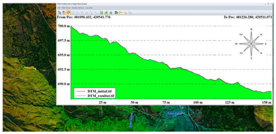
Figure 7.
Variation in the longitudinal profile of the riverbed.
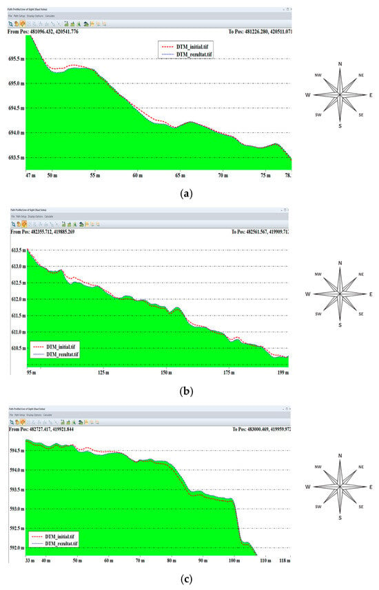
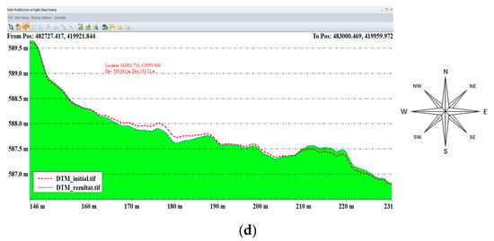
Figure 8.
Variation in the longitudinal profile of the riverbed—longitudinal profile detail (a–d).
Such longitudinal visualization enhances interpretation of sediment transport pathways and supports validation of model performance by correlating morphological evolution with known geomorphological controls and simulation outputs.
Utilizing the post-processing capabilities of the MIKE 21 modelling platform, the total sediment volume mobilized within the study area was quantitatively assessed by comparing the initial Digital Terrain Model (DTM)—representing the pre-simulation streambed morphology—with the raster output derived from the Mud Transport Module simulation. This differential analysis enabled precise calculation of morphological changes attributable to sediment erosion and deposition across the 4.9 km stretch of the Șolea stream.
As illustrated in Figure 9, the volumetric difference between the two surfaces—interpreted as net sediment displacement—was estimated to be 1304.4 cubic metres (m3). This value reflects the cumulative effect of hydrodynamically driven sediment transport over the three-month simulation period, offering insight into the spatial extent and intensity of morphodynamic activity.
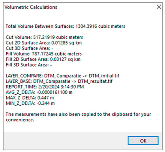
Figure 9.
The total volume of sediments.
Such volume estimates are critical for gauging sediment yield, informing basin-scale sediment budgets, and evaluating the long-term implications of erosional processes on channel stability and aquatic habitat integrity.
The volume of sediment calculated—amounting to 1304.4 m3 over the three-month simulation period—is projected to be discharged into the main emissary, namely the Vâlsan River, downstream of the confluence with the Șolea stream. This influx of alluvial material contributes to a notable increase in sediment loading, fundamentally altering the river’s morphodynamics.
The accumulation of cohesive and fine-grained sediments leads to progressive aggradation of the riverbed, particularly in the minor bed sector of the Vâlsan. As sediment deposition intensifies, the bed elevation rises, resulting in a constriction of the effective flow area, which has several hydrological and environmental consequences:
- -
- Reduced flood conveyance capacity, increasing the risk of overbank flow during peak discharge events.
- -
- Altered hydraulic gradients, potentially changing flow velocity patterns and inducing lateral erosion in adjacent reaches.
- -
- The impact on aquatic habitats, particularly benthic ecosystems that are sensitive to substrate composition and depth variations, is also a concern.
- -
- Increased maintenance demands, such as dredging or bed reconfiguration, to preserve navigability and minimize flood risks.
4. Proposals for Measures for Land Reclamation
These findings underscore the importance of sediment management planning, especially in hydrographic basins with active tributary contributions. Quantifying and predicting sediment flux from minor tributaries like the Șolea stream enables more proactive intervention strategies and supports sustainable watercourse maintenance downstream (Figure 10).
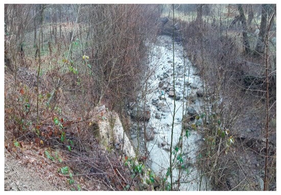
Figure 10.
Proposed area for the placement of the stone dam suite. Photo source: author.
Here is an improved and academically enriched version of your paragraph, Cheveresan, preserving its full length and detail while enhancing clarity, structure, and fluency:
Proposed Preventive Measures for Sediment Control
To mitigate the volume of sediment transported downstream and minimize its adverse impacts on the hydrodynamic functioning of the Vâlsan River, a suite of hydroameliorative interventions is proposed (Figure 11). These preventive measures aim to stabilize the Șolea streambed and reduce erosion in zones with heightened morphodynamic activity.
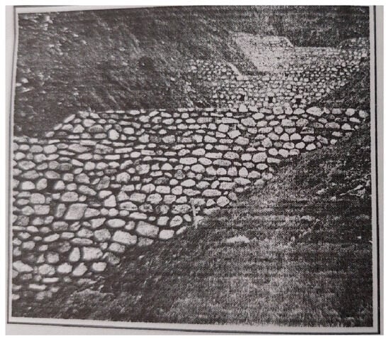
Figure 11.
Example of a series of stone dams with masonry with mortar. Photo source: (Snapshot: S.A. Munteanu).
The proposed works include:
- -
- Transverse Dams:
Constructed from rough stone masonry bonded with cement mortar, these structures act as flow-breakers and sediment traps, attenuating flow velocity and promoting localized sediment deposition.
- -
- Bottom Thresholds:
Strategically positioned in concave sections along the lateral slopes, bottom sills reduce channel incision by dissipating energy and preventing headcut migration. Their placement is informed by channel curvature and erosion hotspots.
- -
- Riparian Vegetation:
Natural vegetation along the riverbanks enhances bank stability, reduces surface runoff energy, and fosters sediment entrapment through root reinforcement and canopy drag effects [25].
- -
- Gabion Retaining Walls:
Installed primarily in slope failure zones, gabions function as flexible, permeable stabilization systems. They address landslip-prone areas by arresting further soil movement and absorbing hydraulic shocks.
The positioning of bed sills is carefully guided by the longitudinal erosion patterns observed in Figure 12, which highlights high-risk zones prone to bed degradation. These visualized trends provide critical input for determining optimal sill spacing and elevation, ensuring that structural countermeasures align with channel evolution and sediment transport pathways.
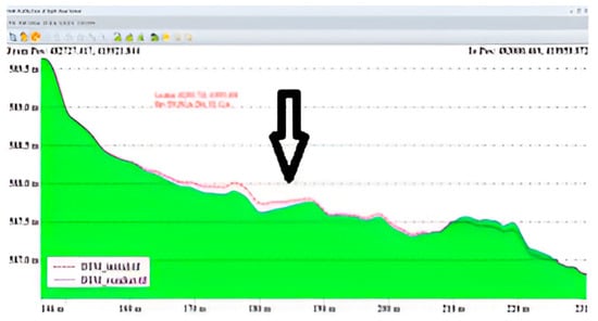
Figure 12.
Evolution of the riverbed—Placement of the riverbed sill.
By implementing these techniques, the integrity of both the minor bed of the Șolea stream and the main channel of the Vâlsan River can be preserved, promoting long-term hydraulic stability and protecting downstream ecosystems from excessive sediment loading.
It is important to note that in the past, anti-erosion stone dams were constructed along the Șolea River to mitigate bed degradation and stabilize the channel (Figure 13). However, over the years, these structures have deteriorated and ultimately disappeared, primarily due to a lack of maintenance and repeated destruction caused by flood events. The absence of these protective installations has contributed to the renewed vulnerability of the riverbed to erosion processes, emphasizing the need for rehabilitation and sustained structural intervention.
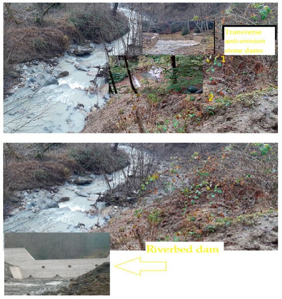
Figure 13.
Proposed area for the construction of a riverbed dam and traverse anti-erosion stone dams. Photo source: author.

Figure 14.
Example of a proposed bottom sill. Photo source: Author.
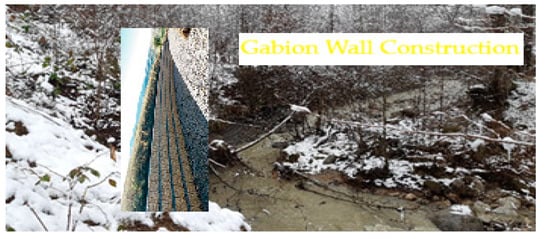
Figure 15.
Proposed area for gabion wall construction.
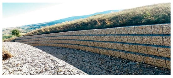
Figure 16.
Example of a gabion wall proposed. Photo source: https://www.revistaconstructiilor.eu/.
These channels are designed to effectively intercept and redirect excess precipitation runoff from adjacent slopes, thereby preventing water infiltration into subsurface layers that are prone to destabilization.
The primary objective of this intervention is to minimize saturation of underlying soil strata, especially those composed of marly clay, which are highly susceptible to plastic deformation and shear failure when exposed to elevated moisture levels. Upon contact with infiltrated water, these layers tend to lose structural cohesion, potentially triggering landslides or progressive mass movement, especially under prolonged precipitation or snowmelt conditions.
By implementing well-graded and strategically aligned drainage channels along the contours of the slope, the hydrostatic pressure within the soil body can be reduced, enhancing overall slope stability and extending the lifespan of nearby infrastructure. This measure complements other slope protection strategies, such as vegetation planting, retaining walls, and geotechnical reinforcement, forming an integrated solution to control erosion and prevent geohazards within the catchment.
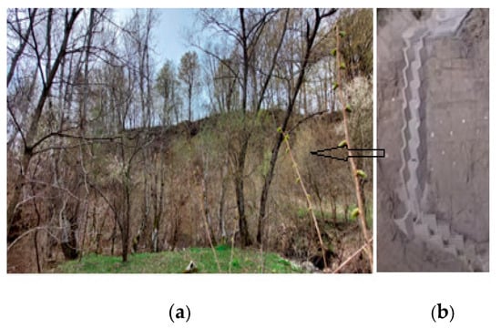
Figure 17.
Example of a surface water drainage channel on a slope source: author (a) and https://www.youtube.com/watch?v=k5P4wqIxEp0, accessed on 1 August 2025 (b).
5. Conclusions
The results obtained in this study underscore the crucial hydromorphological and geotechnical challenges posed by sediment dynamics within small hydrographic basins, such as the Șolea stream catchment. Despite its modest surface area of 6.82 km2, the basin exhibits pronounced sediment transport activity under multiannual average flow conditions. Specifically, a total sediment volume of 1304.4 m3 was recorded over a modelled period of three months, a figure that exceeds typical sediment yield expectations for similarly scaled watersheds.
This substantial sediment flux can be attributed to several interconnected factors:
- -
- Riverbed erosion driven by hydraulic shear stress exceeding critical thresholds for cohesive substrata;
- -
- Slope destabilization linked to excessive surface water infiltration in zones underlain by marly clay layers;
- -
- The absence of functional anti-erosion infrastructure, which was once present, has now deteriorated due to neglect and destruction caused by floods.
The direct implication is a heightened risk of sediment deposition within the Vâlsan River, the primary emissary, where accelerated aggradation processes can elevate the riverbed, narrow the active flow corridor, and reduce hydraulic conveyance capacity. Such changes not only compromise ecological function but also amplify the risk of rapid downstream flooding, particularly in urbanized or agriculturally sensitive areas.
To mitigate these risks, the study highlights the urgent necessity for upstream sediment retention, achievable through a strategic ensemble of hydraulic structures and slope stabilization measures. The proposed interventions include:
- -
- Transverse anti-erosion stone dams (Figure 14), constructed using cement-mortared rockfill for high durability against shock loads and flow-induced vibrations, proven effective in trapping bedload before it reaches the confluence zone [25].
- -
- -
- Bottom weirs and riverbed sills, engineered to dissipate flow energy, reduce longitudinal slope, and prevent channel incision during high-discharge events;
- -
- Drainage channels, targeting surface runoff management in slope areas characterized by high infiltration sensitivity and underlying marly clay formations.
- -
- To mitigate the risks associated with slope instability, particularly those exacerbated by the infiltration of surface water, the construction of drainage channels is proposed—illustrated in Figure 17.
Beyond the technical remedies, this study demonstrates the value of integrated modelling platforms like MIKE 21 in producing reliable sediment volume estimates and in guiding infrastructure planning. Through two-dimensional hydrodynamic simulations and cohesive sediment transport modules, the platform enabled nuanced visualization and quantification of morphodynamic processes, thereby facilitating the identification of risk zones and engineering solutions tailored to local geomorphological and hydrological conditions.
In conclusion, the pairing of advanced modelling techniques with targeted hydroameliorative measures represents a comprehensive management strategy capable of delivering tangible benefits in terms of:
- -
- Environmental protection, through reduced sedimentation and restoration of natural flow regimes;
- -
- Infrastructure resilience, by limiting flood exposure and erosion-induced degradation;
- -
- Community safety, by controlling landslide potential and improving watercourse predictability;
- -
- Sustainable development, by harmonizing hydraulic engineering with ecological preservation.
The methodological framework and preventive measures proposed herein can serve not only as a localized intervention blueprint but also as a scalable reference for similar small-scale basins across the region facing sediment-driven hazards in coupled natural and built environments.
In addition to the conclusions highlighted in the article, we add the importance of identifying erosion and sediment deposition areas for the most accurate picture possible of the set of erosion processes on the riverbed (as highlighted in figure no. 5).
These identifications are very important to know as precisely as possible where the hydrotechnical works necessary to retain sediments can be located as well as the correct arrangement of the river route.
Author Contributions
Conceptualization, M.C. and A.N.; methodology, M.C. and I.-M.C.; soft ware, D.S.; validation, M.C. and L.C.; formal analysis, M.C. and L.C.; investigation, M.C. and A.N.; data curation, M.C.; writing—original draft preparation, M.C. and L.C.; writing—review and editing, M.C. and I.-M.C.; visualization, M.C. supervision, A.N. All authors have read and agreed to the published version of the manuscript.
Funding
This paper has received funding for publication through the University of Bucharest.
Data Availability Statement
The original contributions presented in this study are included in the article. Further inquiries can be directed to the corresponding author.
Acknowledgments
We would like to thank the reviewer for their valuable comments and suggestions to the editors for their serious and responsible attitude, to the publisher for this valuable opportunity.
Conflicts of Interest
The authors declare no conflicts of interest.
References
- Ghitescu, M. Analiza Posibilităților și Limitelor Conceptelor de Modelare a Curgerilor în Sistem 1D, 2D și 3D. Ph.D. Thesis, Polytechnic University of Timisoara, Timișoara, Romania, 2010; pp. 7–9. [Google Scholar]
- Maior, G. Incertitudine, Gândire Strategică și Relații Internaționale în Secolul XXI; Rao Publishing House: Bucharest, Romania, 2009; pp. 20–24. [Google Scholar]
- Hâncu, S. Îndreptar Pentru Calcule Hidraulice; Technical Publishing House: București, Romania, 1988; pp. 1–2. [Google Scholar]
- National Institute of Hydrology and Water Management. Hydrological Study; National Institute of Hydrology and Water Management: Bucharest, Romania, 2025. [Google Scholar]
- Rodriguez, A.N.; Bertrand, N.; Pheulpin, L.; Migaud, A.; Abily, M. Comparison Between HEC-RAS and TELEMAC-2D Hydrodynamic Models of the Loire River, Integrating Levee Breaches. In SimHydro 2023: New ModellingParadigms for Water Issues; Springer: New York, NY, USA, 2023; pp. 41–55. [Google Scholar]
- Bürgler, M.; Vetsch, D.F.; Boes, R.M.; Vanzo, D. Systematic comparison of 1D and 2D hydrodynamic model for the assessment of hydropeaking alterations. River Res. Appl. 2022, 39, 460–477. [Google Scholar] [CrossRef]
- Vahidifar, S.; Saffarian, M.R.; Hajidavalloo, E. Introducing the theory of successful settling in order to evaluate and optimize the sedimentation tanks. Meccanica 2018, 53, 3476–3492. [Google Scholar] [CrossRef]
- Horritt, M.S.; Bates, P.D.; Fewtrell, T.J.; Mason, D.C.; Wilson, M.D. Modelling the hydraulics of the Carlisle 2005 flood event. Proc. Inst. Civ. Eng. Water Manag. 2010, 163, 273–281. [Google Scholar] [CrossRef]
- Miremad, S.; Concilio, G.; Azzellino, A. Sustainable Urban Drainage Systems for reducing Flood Risk at the Catchment Scale: The Seveso River Basin Case Study. Athens J. Technol. Eng. 2025, 12, 1–17. [Google Scholar]
- Bajcar, T.; Gosar, L.; Širok, B.; Steinman, F.; Rak, G. Influence of flow field on sedimentation efficiency in a circular settling tank with peripheral inflow and central effluent. Chem. Eng. Process. Process. Intensif. 2010, 49, 514–522. [Google Scholar] [CrossRef]
- Ackers, P.; White, W.R. Sediment transport: New approach and analysis. J. Hydraul. Div. 1973, 99, 2041–2060. [Google Scholar] [CrossRef]
- Ashida, K.; Michiue, M. Study on hydraulic resistance and bed-load transport rate in alluvial streams. Proc. Jpn. Soc. Civ. Eng. 1972, 206, 59–69. [Google Scholar] [CrossRef] [PubMed]
- Engelund, F.; Fredsøe, J. A sediment transport model for straight alluvial channels. Hydrol. Res. 1976, 7, 293–306. [Google Scholar] [CrossRef]
- Engelund, F.; Hansen, E. A Monograph on Sediment Transport in Alluvial Streams; Teknisk Forlag: Copenhagen, Denmark, 1967. [Google Scholar]
- Van Rijn, L.C. Sediment transport, Part I: Bed load transport. J. Hydraul. Eng. ASCE 1984, 110, 1431–1456. [Google Scholar] [CrossRef]
- Van Rijn, L.C. Unified view of sediment transport by currents and waves. II: Suspended transport. J. Hydraul. Eng. ASCE 2007, 133, 668–689. [Google Scholar] [CrossRef]
- Dobrot, R. Hidrologie si Hidrogeologie; Editura Tehnica si Pedagogica, S.A: Bucharest, Romania, 2020; pp. 10–15. [Google Scholar]
- Grecu, F.; Zaharia, L.; Ioana-Toroimac, G.; Armas, I. Floods and Flash-Floods Related to River Channel Dynamics. In Landform Dynamics and Evolution in Romania; Springer Geography; Radoane, M., Vespremeanu-Stroe, A., Eds.; Springer: Cham, Switzerland, 2017; pp. 821–844. [Google Scholar]
- Stamou, A.I.; Adams, E.W.; Rodi, W. Numerical modeling of flow and settling in primary rectangular clarifiers. J. Hydraul. Res. 1989, 27, 665–682. [Google Scholar] [CrossRef]
- Chow, V.T. Open-Channel Hydraulics; McGraw-Hill: New York, NY, USA, 1959. [Google Scholar]
- Van Rijn, L.C. Principles of Sediment Transport in Rivers, Estuaries and Coastal Seas; Aqua Publications: Amsterdam, The Netherlands, 1993. [Google Scholar]
- Shahrokhi, M.; Rostami, F.; Said, M.A.M. Numerical modeling of baffle location effects on the flow pattern of primary sedimentation tanks. Appl. Math. Model. 2013, 37, 4486–4496. [Google Scholar] [CrossRef]
- Sevachko, H. DHI Education Resource Guide; University of Copenhagen: Copenhagen, Denmark, 2017. [Google Scholar]
- Liu, Y.L.; Zhang, P.; Wei, W. 2D Simulation of Effects of Position of Baffles on the Removal Rate of Solids in a Sedimentation Tank. Appl. Mech. Mater. 2012, 253–255, 861–864. [Google Scholar]
- Clinciu, I.; Lazăr, N. Lucrări de Amenajare a Bazinelor Hidrografice Torențiale; Editura Didactică şi Pedagogică Bucureşti: Bucureşti, Romania, 1997; pp. 56–60. [Google Scholar]
Disclaimer/Publisher’s Note: The statements, opinions and data contained in all publications are solely those of the individual author(s) and contributor(s) and not of MDPI and/or the editor(s). MDPI and/or the editor(s) disclaim responsibility for any injury to people or property resulting from any ideas, methods, instructions or products referred to in the content. |
© 2025 by the authors. Licensee MDPI, Basel, Switzerland. This article is an open access article distributed under the terms and conditions of the Creative Commons Attribution (CC BY) license (https://creativecommons.org/licenses/by/4.0/).