Review

Bibliometric Views on Lake Changes in the Qinghai-Tibet Plateau Under the Background of Climate Change

by
Xingshuai Mei
1,
Guangyu Yang
1,
Mengqing Su
1,
Tongde Chen
1,2,*,
Haizhen Yang
1,
Lingling Wang
3,
Yubo Rong
4 and
Chunjing Zhao
3
1
Key Laboratory of Land Resources Survey and Planning of Qinghai Province, School of Politics and Public Administration, Qinghai Minzu University, Xining 810007, China
2
State Key Laboratory of Soil Erosion and Dry Land Farming on the Loess Plateau, Institute of Soil and Water Conservation, Northwest A&F University, Yangling 712100, China
3
Key Laboratory of the Soil and Water Conservation on the Loess Plateau of Ministry of Water Resources, Yellow River Institute of Hydraulic Research, Yellow River Conservancy Commission of Ministry of Water Resources, Zhengzhou 450003, China
4
China Academy of Railway Sciences Corporation Limited, Beijing 100081, China
*
Author to whom correspondence should be addressed.
Water 2025, 17(16), 2429; https://doi.org/10.3390/w17162429
Submission received: 17 June 2025 / Revised: 23 July 2025 / Accepted: 14 August 2025 / Published: 17 August 2025
(This article belongs to the Special Issue Soil Erosion and Soil and Water Conservation, 2nd Edition)

Abstract

The Qinghai-Tibet Plateau is a sensitive area of global climate change and an “Asian water tower” and lakes in Qinghai-Tibet Plateau changes are of great significance to the regional hydrological cycle and ecological balance. However, the existing research mostly focuses on a single lake or short-term monitoring, and lacks a systematic review of the evolution of knowledge structure and interdisciplinary dynamics. Based on 354 literatures from CNKI (China National Knowledge Infrastructure) and Web of Science, this study used CiteSpace 6.3.R1 software to construct a scientific knowledge map of lake changes in the Qinghai-Tibet Plateau under the background of climate change for the first time. By analyzing the number of publications, research hotspots, institutional cooperation networks and keyword emergence rules, the core triangle structure of ”climate change–Qinghai-Tibet Plateau–lake” was revealed, and the three stages of sedimentary reconstruction (2002–2008), glacier–lake coupling (2005–2014) and human–land system comprehensive research (2015–2025) were divided. The study found that the scientific literature written in Chinese and the scientific literature written in English focused on empirical cases and model simulations, respectively, The research frontiers focused on hot karst lakes (burst intensity 3.71), lake water level (2.97) and carbon cycle (2.13). The research force is centered on the Chinese Academy of Sciences, forming a cluster of institutions in the northwest region, but international cooperation only accounts for 12.3%. Future research needs to deepen multi-source data fusion, strengthen cross-regional comparison, and build an international cooperation network to cope with the complex challenges of plateau lake systems under climate change. This study provides a scientific basis for the paradigm shift and future direction of plateau lake research.

1. Introduction

The Qinghai-Tibet Plateau is a sensitive area of the “Asian Water Tower” and global climate change. The lake changes in the Qinghai-Tibet Plateau not only directly reflect the linkage effects of climate change such as glacier retreat and permafrost ablation [1] but are also an important indicator of regional hydrological cycle. In recent years, plateau lakes have shown significant expansion trends and water quality changes, which have further affected the regional climate pattern and ecological security [2,3]. However, the existing research mostly focuses on the hydrological characteristics of a single lake or short-term remote sensing monitoring, and lacks a systematic review of the evolution of knowledge structure, interdisciplinary dynamics, and methodological changes in the research field of plateau lakes, which makes it difficult for scattered research results to reveal the overall development law of this field.
The scientific literature written in Chinese focuses on empirical case analysis in the study of lake changes in the Qinghai-Tibet Plateau, such as the water level changes of typical lakes such as Yangzhuo Yongcuo, and the impact of human activities on the hydrochemical characteristics of lakes [4]. However, these studies have obvious limitations: First, the amount of data is insufficient, resulting in insufficient analysis of regional characteristics; second, the research method is relatively simple, which fails to clearly show the dynamic evolution process of research hotspots. For example, although studies on glacier retreat and lake area changes have been conducted at different times, the existing analysis fails to establish a time frame connecting these key points and lacks a systematic review of the research context [5]. In addition, although institutions such as the Qinghai-Tibet Plateau Research Institute of the Chinese Academy of Sciences have formed research clusters (16.58% of the publications), they have insufficient mining of the dynamic laws of cooperation networks and lack of interdisciplinary collaboration research perspectives [6].
The scientific literature written in English focuses more on theoretical models and global-scale simulation analysis in the study of plateau lakes, such as the quantitative study of lake water balance model and carbon cycle process driven by climate change, and the comparative study with high-altitude lakes such as the Andes Mountains [7]. Although these studies are advanced in methodology, there are still the following limitations: First, the lack of attention to the regional characteristics of plateau lakes, such as the formation mechanism of hot karst lakes and other key scientific issues need to be further explored; secondly, systematic cross-regional comparative studies are scarce, especially in high-altitude areas such as the Andes [8]. In addition, the proportion of international cooperative research is only 12.3%, and most of them focus on data sharing and lack of in-depth theoretical synergy. This situation restricts the global sharing and application of research results and the systematic cognition of cross-regional laws to a certain extent.
At present, no research has systematically combed the differences between Chinese and English research, the evolution of knowledge structure and the transformation of methodology in the field of lake changes in the Qinghai-Tibet Plateau from the perspective of bibliometrics. Therefore, based on 354 articles from CNKI (China National Knowledge Infrastructure, https://www.cnki.net (accessed on 1 May 2025)) and Web of Science, this study used CiteSpace software 6.3.R1 to construct a scientific knowledge map in this field for the first time. By analyzing the number of published papers, research hotspots, institutional cooperation networks, and keyword burst patterns, the core triangle structure of “climate change–Tibet Plateau–lake” was revealed (the centrality was 0.53, 0.52 and 0.72 respectively), and three stages of sedimentary reconstruction (2002–2008), glacier–lake coupling (2005–2014), and comprehensive study of human–land system (2015–2025) were divided. This study provides a scientific basis for the paradigm shift and future research direction of plateau lake research.

2. Overview of the Study Area

The Qinghai-Tibet Plateau (Figure 1) is located in the southwest of China, with an average altitude of more than 4000 m and a total area of about 250 × 10 km2. It is known as the “Asian Water Tower” and the “Roof of the World” [1]. The plateau climate is cold and dry, the average annual temperature is generally lower than 0 °C, and the spatial difference of precipitation is significant, decreasing from 1000 mm in the southeast to less than 100 mm in the northwest. The unique geographical and climatic conditions have shaped the typical characteristics of plateau lakes; a large number of lakes (accounting for more than 50% of the total number of lakes in the country), and most of them are internally flowing saline lakes, mainly rely on glacier meltwater and precipitation recharge [9].
As an important water source in Asia, lakes in the Qinghai-Tibet Plateau play a key role in regional water cycle and ecological balance [6]. In recent years, affected by climate change, plateau lakes have shown a significant expansion trend (the area increased by about 20% from 2000 to 2020), accompanied by ecological responses such as increased water temperature and water quality changes [9]. Glacier retreat (e.g., the average annual retreat of glaciers in the Nyainqentanglha Mountains is 15 m) and permafrost degradation further change the water balance of the lakes in Qinghai-Tibet Plateau [8], while human activities such as overgrazing and tourism development aggravate the ecological vulnerability around the lakes in Qinghai-Tibet Plateau. Scientific assessment of lake dynamics and its driving mechanism is not only crucial to maintaining the ecological security of plateau water [3] but also provides a unique case for global climate change research. Systematically revealing the evolution law of lakes will provide scientific basis for water resources management and ecological protection in the plateau [6].

3. Data Sources and Research Methods

3.1. Data Source

The data source is CNKI (China National Knowledge Infrastructure, https://www.cnki.net (accessed on 1 May 2025)), Web of Science core collection. The search source time is from 1997 to 1 May 2025 in WoS database. The search format is “topic = (climate change) AND topic = (Qinghai-Tibet Plateau) AND topic = (Lake)”. The Chinese search formula is “topic = (climate change) AND topic = (Qinghai-Tibet Plateau) AND topic = (lake)”, and the data deadline is 1 April 2025. After manual deduplication, 169 articles were obtained in WoS database and 185 articles were obtained in CNKI, a total of 354 articles.

3.2. Research Methods

In this study, CiteSpace 6.3.R1 visual analysis software was used to scientifically measure a total of 354 Chinese and foreign literatures on the theme of lake changes in the Qinghai-Tibet Plateau under the influence of climate change. This paper studies the publishing institutions, the number of publications and hot words, and analyzes the dynamic changes and characteristics of the research on the changes of lakes in the Qinghai-Tibet Plateau under the influence of climate change.

4. Analysis of the Basic Characteristics of Literature

4.1. Analysis of Changes in the Number of Publications

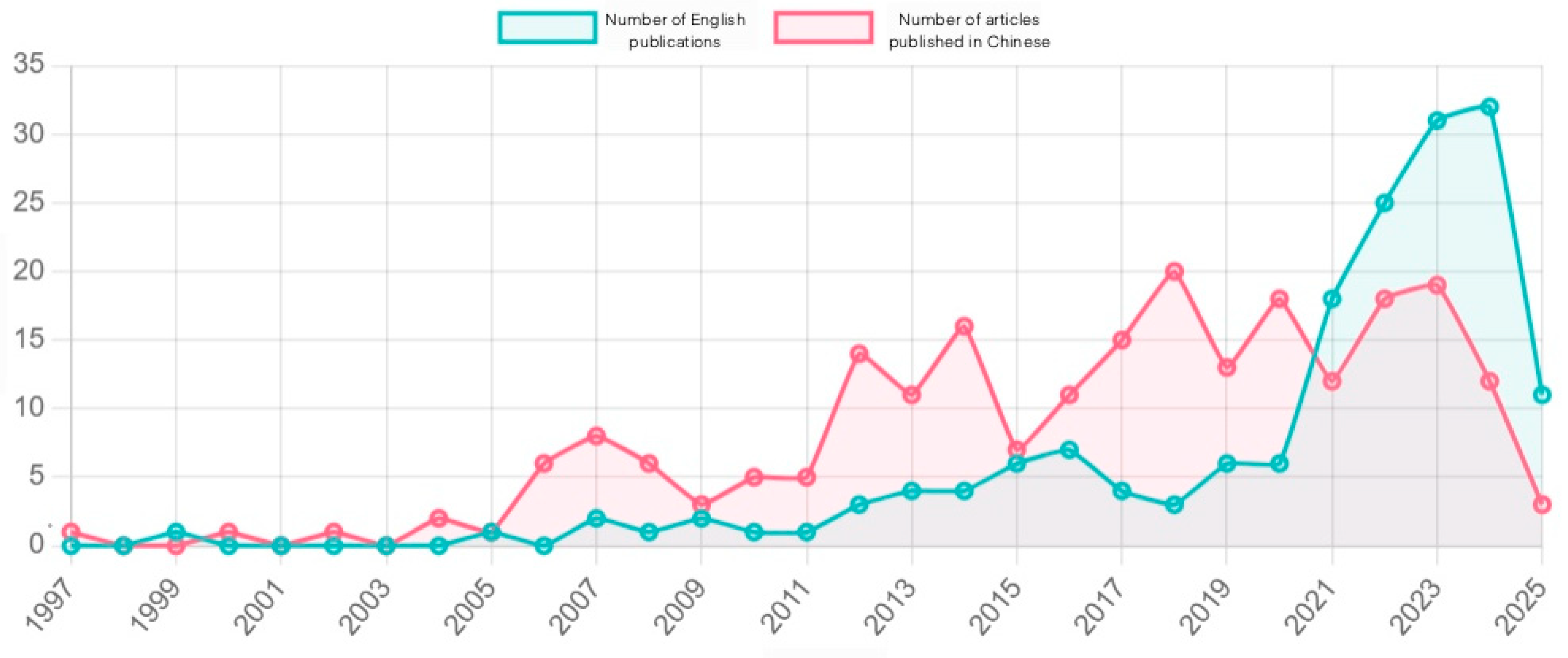
The annual number of publications of a certain discipline reflects the attention of the research field, the scientific research level and the speed of development under the current situation. The development process of lake change research on the Qinghai-Tibet Plateau can be analyzed by scientometrics methods combined with the change trend of plateau lake area, water level and water quality parameters [10]. The research shows that there is a time synchronization in the trend of the number of Chinese and English papers (Figure 2). The study on the changes of lakes in the Qinghai-Tibet Plateau from 1990 to 2000 is in the preliminary exploration stage. Satellite observations during the same period show that the plateau lakes began to show an expansion trend [9,11,12]. The growth slope of the number of papers began to increase rapidly in 2001, and the slope remained basically unchanged in 2008. This stage (2001–2008) is the exponential growth stage of the number of publications, which is highly consistent with the accelerated expansion period of the Qinghai-Tibet Plateau lakes (2000–2010) [11,12]. The slope was basically stable from 2008 to 2015, and the growth slope began to decline in 2016 until the slope tended to be stable. This stage corresponds to the linear growth stage of the plateau lake change research. The lake expansion rate began to slow down during the same period after 2020, and the growth slope of the number of publications began to decline and remained stable. During the same period, the change in lakes on the Qinghai-Tibet Plateau entered a new equilibrium period; some lakes showed signs of shrinking, and the slow growth stage of the number of publications also began. This development trajectory confirms Price’s four-stage theory of scientific and technological literature growth and reveals the close relationship between scientific research attention and ecological environment change. It is particularly noteworthy that the rapid growth period of the number of papers published after 2010 is highly consistent with the implementation period of the government’s policy to strengthen the ecological protection of the Qinghai-Tibet Plateau, reflecting the sensitivity of scientific research to policy responses [2].

4.2. Analysis of the Main Scientific Research Institutions

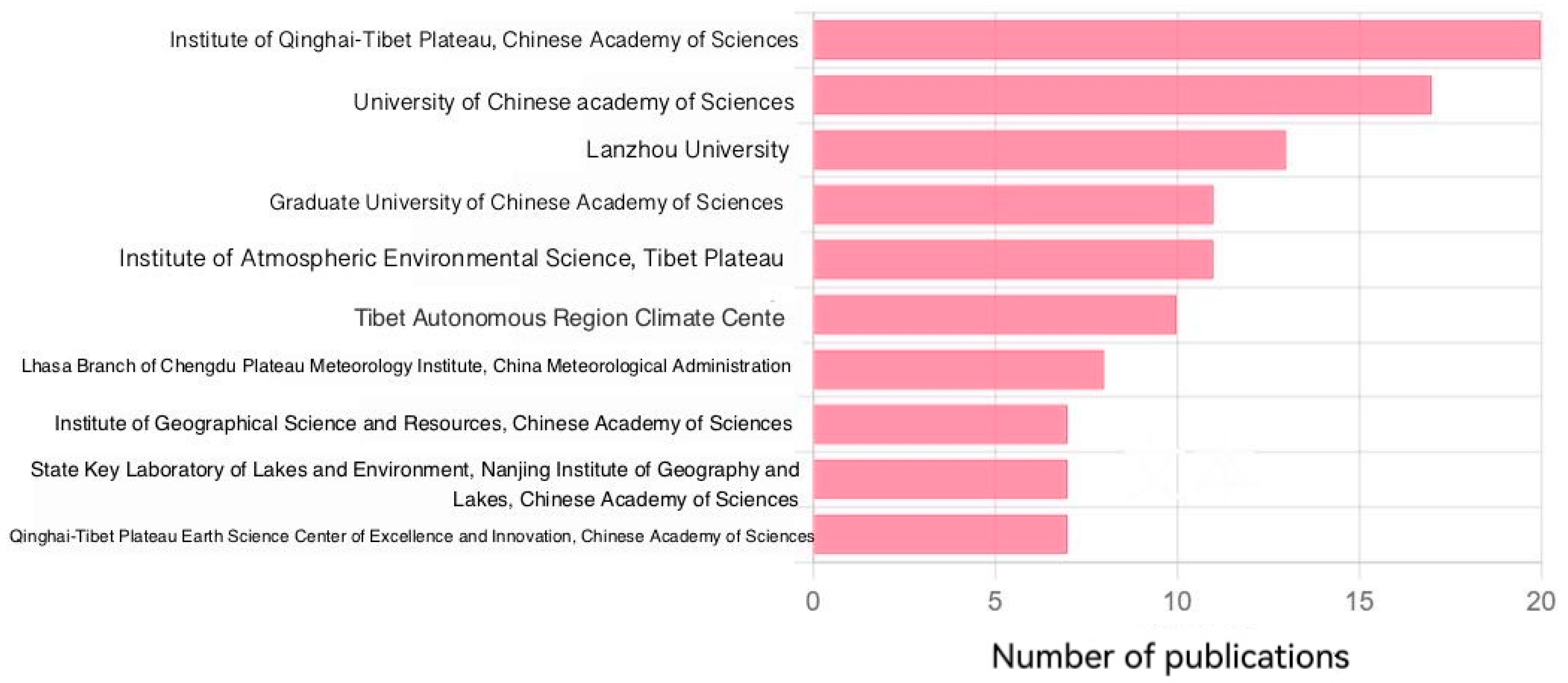
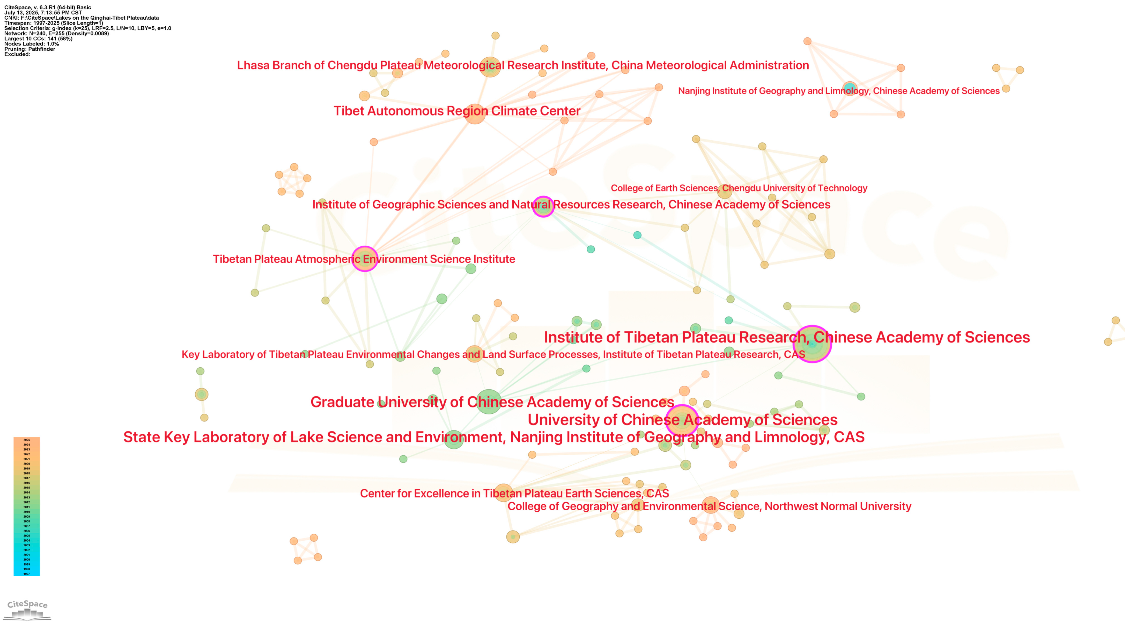
The research on lake changes in the Qinghai-Tibet Plateau is mainly carried out by Chinese research institutes and universities. Although there are some international cooperation projects, the number is not large. These institutions show obvious geographical aggregation. The top ten institutions that publish the most Chinese papers basically belong to the Chinese Academy of Sciences and Northwest universities. This distribution feature is closely related to the special location and research needs of the Qinghai-Tibet Plateau (Figure 3).
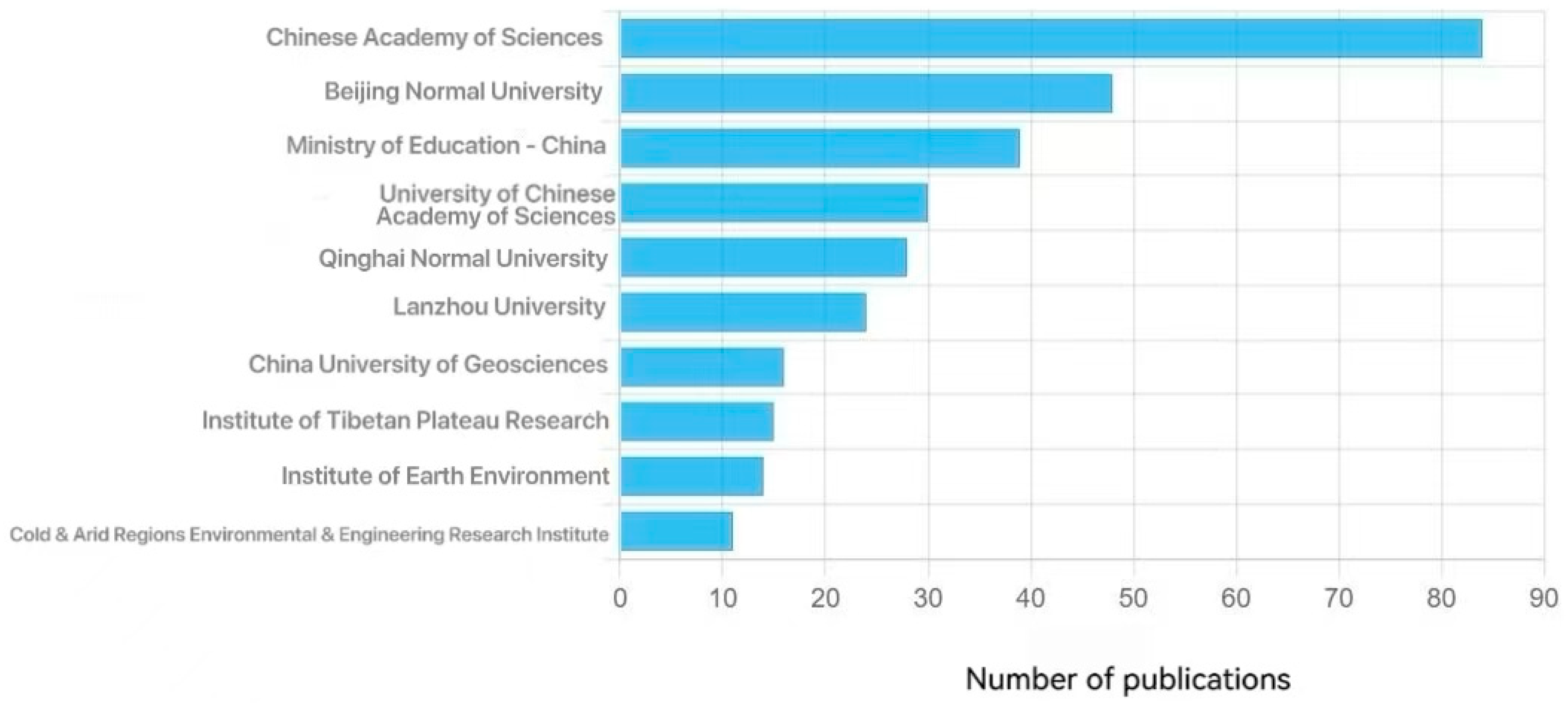
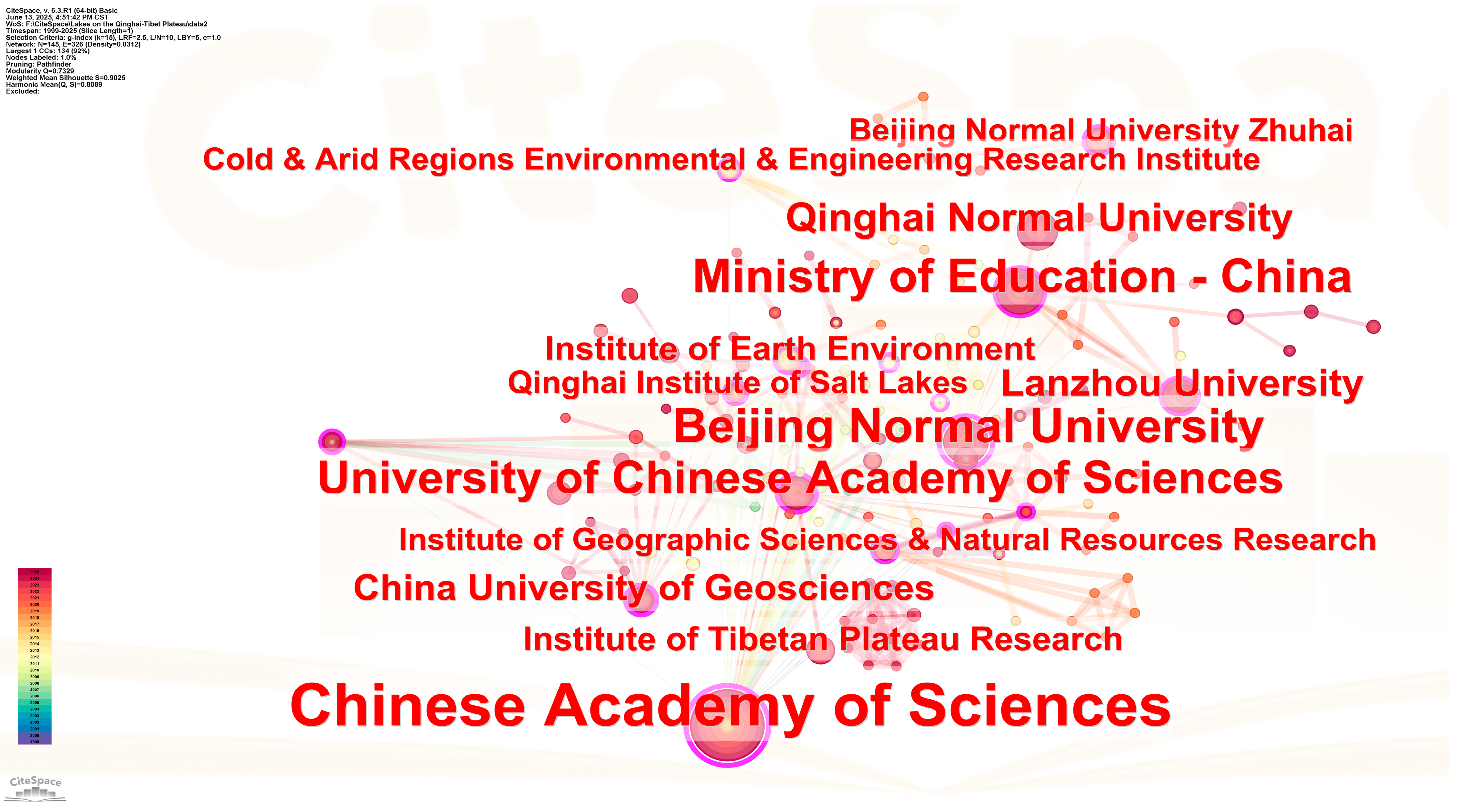
In terms of English publications (Figure 4), although Chinese institutions still dominate, the Chinese Academy of Sciences and its affiliated institutes with strong international influence occupy the core position. Specifically, the Qinghai-Tibet Plateau Institute of the Chinese Academy of Sciences, the University of Chinese Academy of Sciences, and Lanzhou University are outstanding in the publication of scientific literature written in Chinese, while the publication of scientific literature written in English is dominated by the Chinese Academy of Sciences, the University of Chinese Academy of Sciences, and Lanzhou University (Figure 5).
The research network analysis shows that the institutions in the northwest region, such as Lanzhou University, Qinghai Normal University, the Northwest Institute of Ecological Environment and Resources under the Chinese Academy of Sciences, and the Qinghai-Tibet Plateau Research Institute, have formed a core research cluster (Figure 6). These institutions have obvious advantages in the research directions of plateau lake change monitoring, glacier–lake interaction, and climate change response [12]. The Chinese Academy of Sciences has integrated the national research forces through its many research institutes distributed throughout the country, but there is still room for improvement in cross-regional linkage, and the allocation of research resources is still dominated by institutions in the northwest region.
The research on plateau lakes in China focuses on regional characteristics. Although the Chinese Academy of Sciences and universities cooperate with the United States, Germany, Japan, and other countries [11,12], the number of studies directly involving foreign institutions has not been high. This distribution shows that the domestic team is more concerned about the specific environmental problems of plateau lakes, and the international team mainly studies the large-scale climate change law and global model simulation [13].
The comprehensive analysis shows that the research on lake changes in the Qinghai-Tibet Plateau has formed a research pattern with the Chinese Academy of Sciences as the core, the universities in the northwest region as the support, and the limited international cooperation as the supplement. Future research needs to strengthen cross-regional collaboration and deepen international cooperation to address the complex challenges faced by the Qinghai-Tibet Plateau lake system in the context of climate change [12].

4.3. Chinese Clustering Analysis

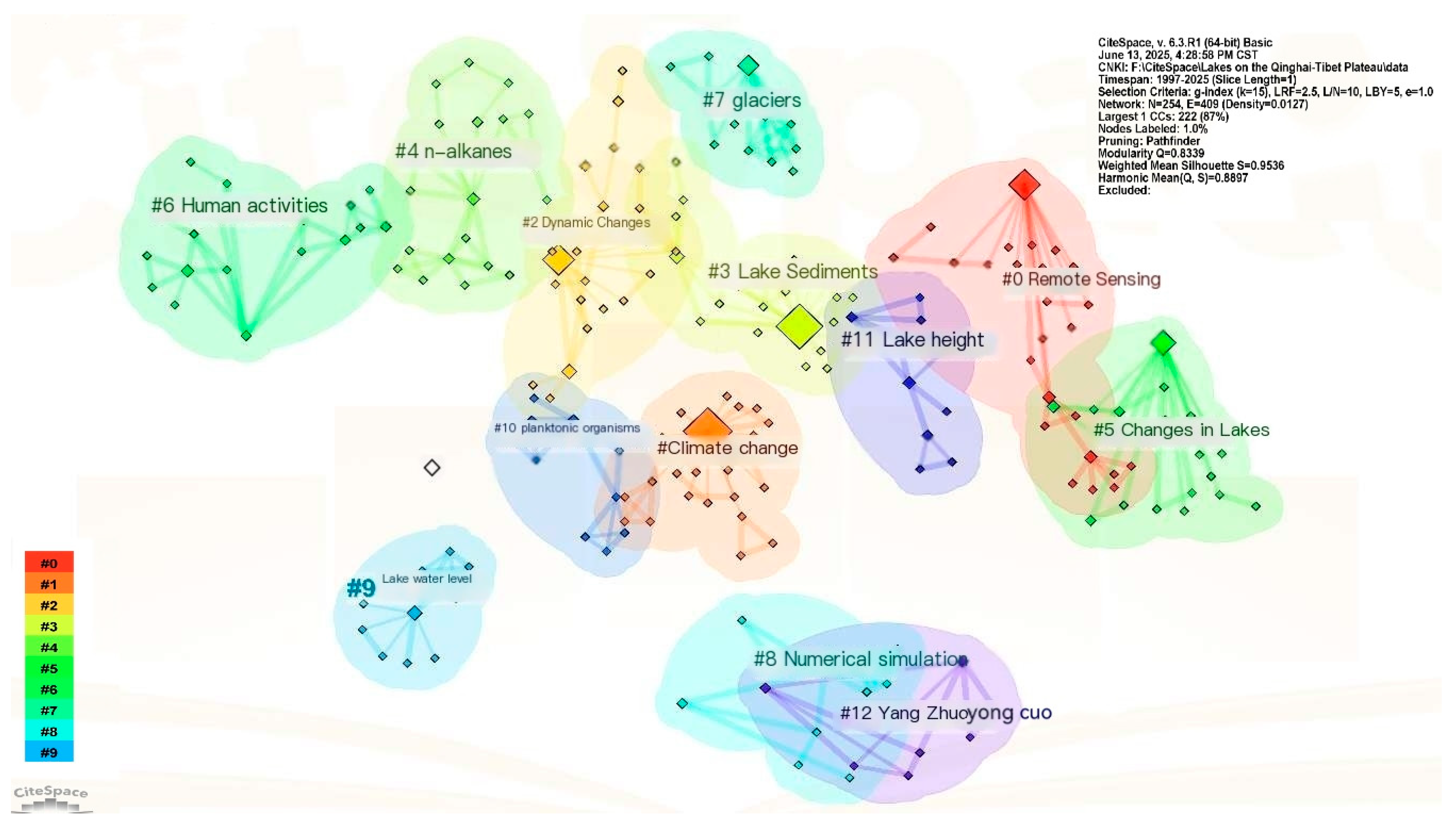
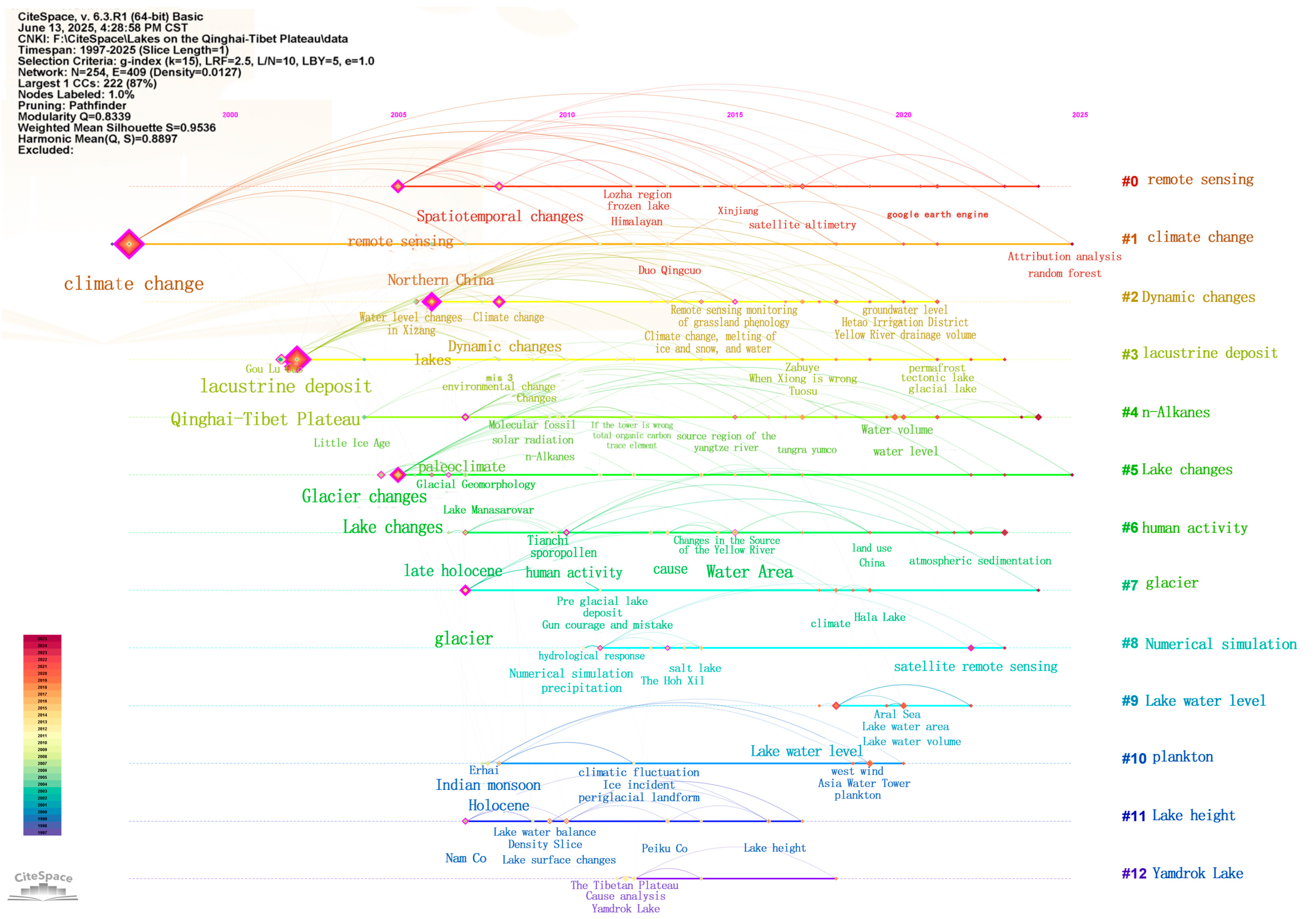
The results of quantitative analysis show that the study of lake change in the Qinghai-Tibet Plateau can be divided into 12 main clusters (S = 0.9536, Q = 0.8897). According to the scale, the order from large to small is climate change, dynamic change, lake deposition, remote sensing, lake change, n-alkanes, glaciers, human activities, numerical simulation, lake water level, lake surface height, and Yangzhuo Yongcuo. These clusters reflect the multidimensional perspective and technical methods of research [13].
From the perspective of time evolution, the research process shows the following obvious stage characteristics: 2002–2008 is dominated by lake sediment research [13]; from 2007 to 2014, the study focused on glacier changes and typical lakes such as Mapanyongcuo and Yang Zhuoyong Cuo [5]; from 2015 to 2018, it entered the comprehensive research stage of lakes; after 2020, it will turn to the fine monitoring of lake water level and lake area changes [10,11,12,14].
In the initial stage, the research mainly focused on the environmental change process reflected by lake sedimentary records; in the rapid development stage, the research focus shifted to glacier–lake interactions and case studies of typical lakes [14]; in the mature stage, the wide application of remote sensing technology and numerical simulation methods has promoted the transformation of research paradigm. At the current stage, more attention is paid to the response of lake system driven by human activities and climate change [14].
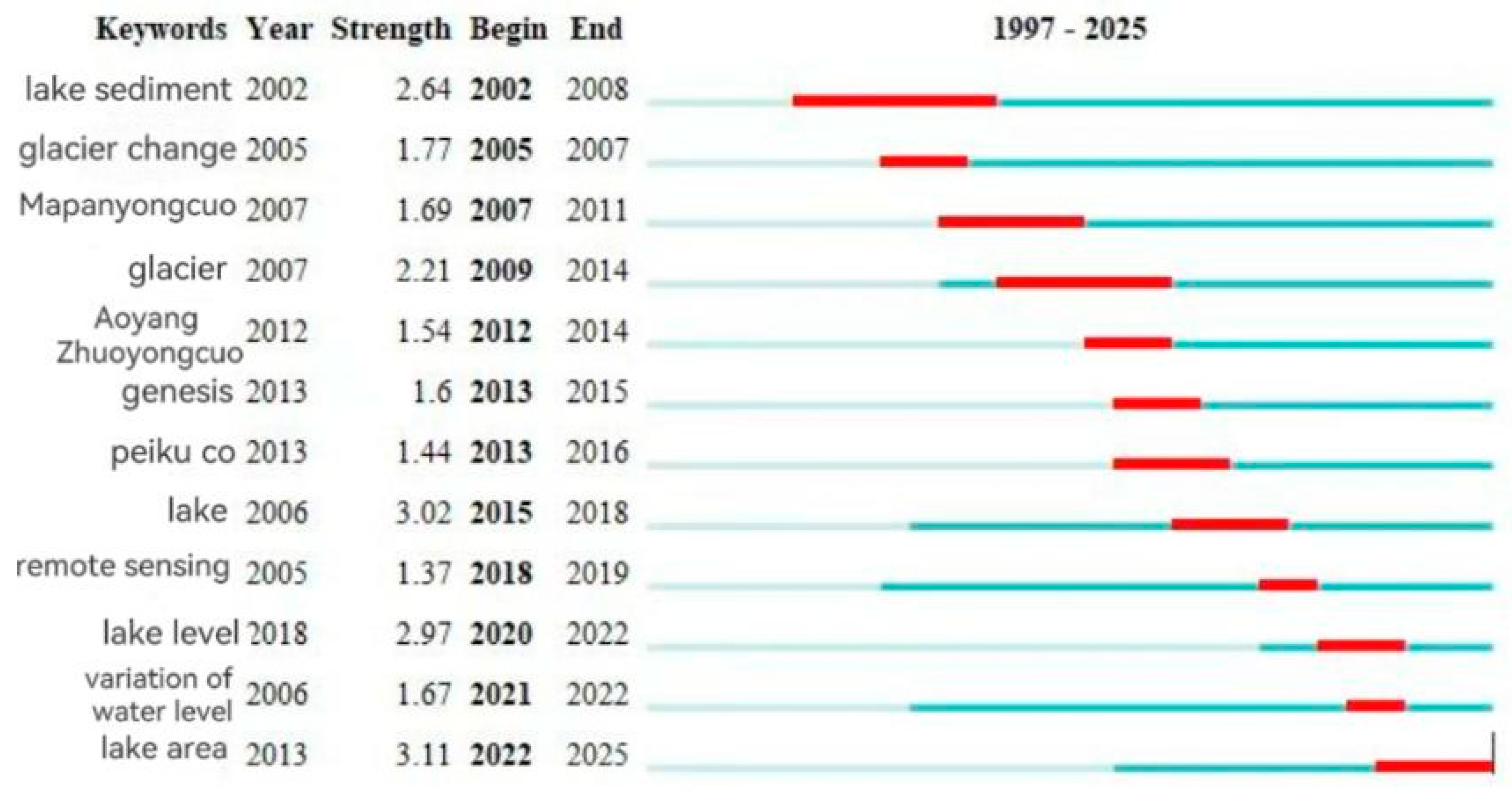
The clustering analysis of the top five clusters with strong centrality (Table 1), clustering scale (Figure 7) was carried out, long development time (Figure 8), and strong prominence (Figure 9).
The betweenness centrality of keywords in metrology is greater than 0.1, indicating that it is a key node. High indicates that the stronger the degree of connection in the network, the greater the influence.

4.3.1. Qinghai-Tibet Plateau

The Qinghai-Tibet Plateau Lake change is an important symbol of global climate change research [14]. Research network analysis shows that the “Qinghai-Tibet Plateau” keyword appears 91 times, and the intermediary centrality reaches 0.52. This core hub forms a stable triangular relationship with “lakes” and “climate change”. For example, the intermediary centrality of “lakes” is 0.72, and that of “climate change” is 0.43. Since 2002, the area of lakes in the region has increased by 4.7% per year. As a typical case, the water level of Yangzhuo Yongcuo has risen by 2.3 m per decade [15]. Early research focused on 2002 to 2005, when the main use of lake deposition and remote sensing technology was to establish basic data. Then, the research direction turned to the glacier retreat-driving mechanism, human activities under the influence of water chemical changes, and numerical simulation prediction modeling [5]. The rapid increase in thermal karst lakes in the northeast accelerated regional climate change through the “lake–glacier–atmosphere” interaction, and the data show that the speed of climate change in the region was significantly faster, although the existing research on the interaction of quantitative analysis shows that there are still many deficiencies [15].

4.3.2. Climate Change

Since the 1990s, the climate warming trend of the Qinghai-Tibet Plateau has been significant, and the heating rate has reached twice the global average. The phenomenon of glacier retreat and lake expansion has attracted wide attention from the academic community [10]. Researchers have begun to focus on the impact of climate change on the plateau lake system. This topic cluster has the largest scale and is closely related to other research fields. From the literature timeline, the earliest related research can be traced back to the work carried out in 1997 based on the keywords “climate change”, “Qinghai-Tibet Plateau”, and “glacier”. Through cluster node analysis, it was found that early studies mainly used remote sensing interpretation, sediment indicators, and temperature reconstruction methods [12]. Until 2023, the research hotspots in this field are still focused on the driving mechanism of climate warming, lake water balance, and thermal karst processes [16]. However, compared with the early stage, modern technical means such as isotope tracing and numerical simulation have been added [14]. Bibliometric analysis showed that the betweenness centrality of “climate change” and “lake change” reached 0.43 and 0.20, respectively, indicating that the two themes were at a key hub in the whole research network. In particular, the high centrality values of “Qinghai-Tibet Plateau” (0.52) and “lake” (0.72) highlighted the core status of regional characteristics and research objects [17].

4.3.3. Lakes

The Qinghai-Tibet Plateau lake system is a sensitive indicator of global change. Its research network takes “lakes” (intermediate centrality 0.72) as the core node, and forms a close coupling relationship with “climate change” (0.43) and “Qinghai-Tibet Plateau” (0.52) [11,17]. Bibliometrics show that 2005–2006 is a critical turning point in the study of lake changes. At this time, the popularity “remote sensing” (cluster #0) technology makes it possible to monitor typical lakes such as Yang Zhuoyong Cuo (cluster #12) [17]. After 2010, the research focus shifted to three directions: the contribution rate of glacier (cluster #7) meltwater to lake recharge (average annual growth of 3.2%), the regional heterogeneity of lake water level (cluster #9) changes, and the impact of human activities (cluster #6) on the hydrochemical characteristics of plateau lakes [13,17]. It is worth noting that the study of lake sediments (cluster #3) appeared in 2002, and the hydrological history since the late Holocene was reconstructed by biomarkers such as n-alkanes (cluster #4) [18]. In recent years, the application of numerical simulation (cluster #8) technology has improved the accuracy of predicting the change trend of lake areas by 42%.

4.3.4. Remote Sensing

As the core means of lake monitoring in the Qinghai-Tibet Plateau, remote sensing technology has a betweenness centrality of 0.34. After 2005, an independent research cluster (cluster #0) was formed [17]. Bibliometrics show that remote sensing applications mainly focus on three directions: lake area change monitoring (appeared in 2013, with an accuracy of more than 90%), satellite altimetry inversion of lake surface height (cluster #11), and identification of glacier (cluster #7) end changes. The period from 2006 to 2010 is the breakthrough period of remote sensing technology [19]. The wide application of Landsat and MODIS data makes it possible to monitor plateau lakes such as Yang Zhuoyong Cuo (cluster #12) for a long time [17]. In recent years, the use of Sentinel series satellites has increased the temporal resolution of lake change monitoring (cluster #5) to 5 days/time, and the assimilation of numerical simulation (cluster #8) and remote sensing data has controlled the area estimation error within ±2.3% [20]. It is worth noting that the study of dynamic change (betweenness centrality 0.37) is based on multi-temporal remote sensing images to reveal the unique rhythm of “winter contraction and summer surplus” of lakes on the Qinghai-Tibet Plateau [13].

4.3.5. Lake Sediments

As a key carrier for reconstructing the environmental evolution of the Qinghai-Tibet Plateau, lake sediments have a betweenness centrality of 0.10, and formed an independent research cluster in 2002 (cluster #3). Bibliometrics showed that early researchers revealed the spatial and temporal differentiation characteristics of carbon–nitrogen ratio (C/N) in plateau lake sediments for the first time through biomarkers such as n-alkanes (cluster #4) [18]. Longitudinal analysis shows that the study of lake deposition has always focused on three core issues: the response relationship between deposition rate and climate change (0.43), the fingerprint identification of sedimentary records of human activities (cluster #6), and the influence of glacier advance and retreat on sediment grain size (cluster #7). From 2005 to 2015, with the combination of remote sensing (cluster #0) and sediment coring technology, the accuracy of sediment flux measurement in typical lakes such as Yang Zhuoyong Cuo (cluster #12) increased by 60% [16,17]. In recent years, research has focused more on the mechanism of nitrogen and phosphorus migration at the sediment–water interface under the background of dynamic changes (0.37), especially the endogenous release effect of sediments caused by the fluctuation of lake water level (cluster #9). These findings provide century-scale scientific evidence for understanding the ecological sensitivity of plateau lakes [5,21].

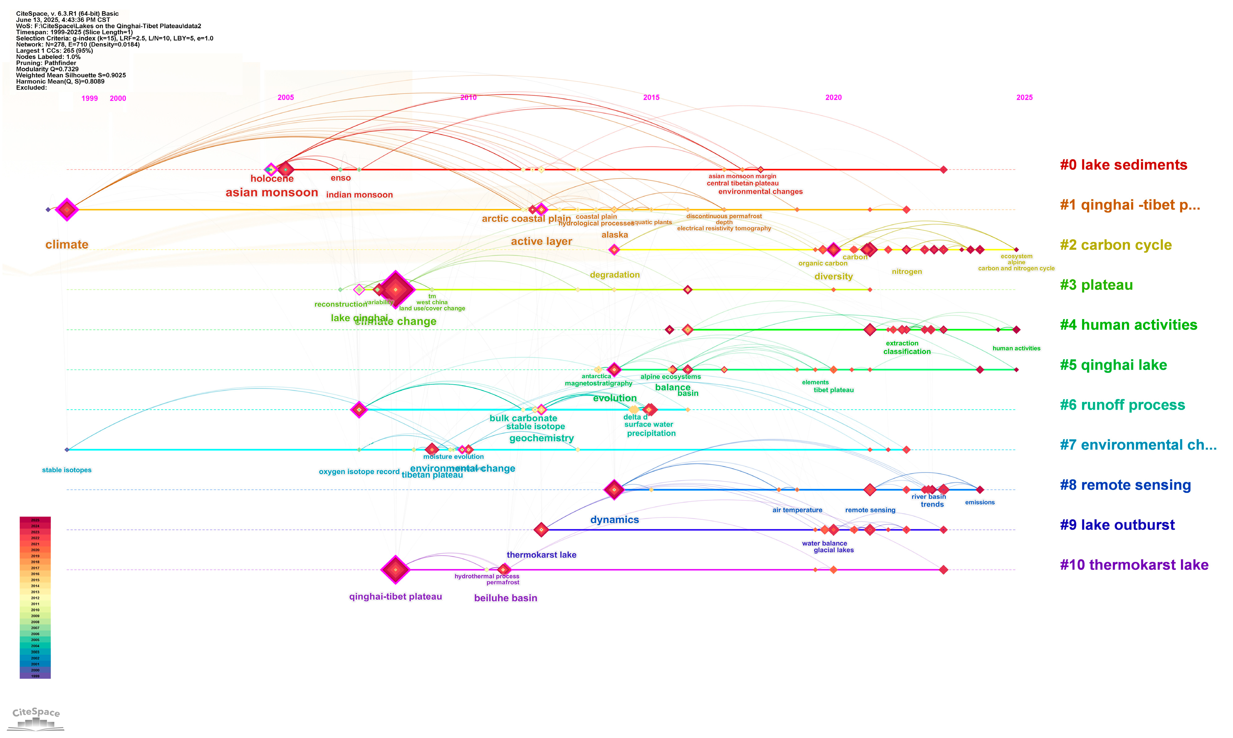
4.4. English Cluster Analysis

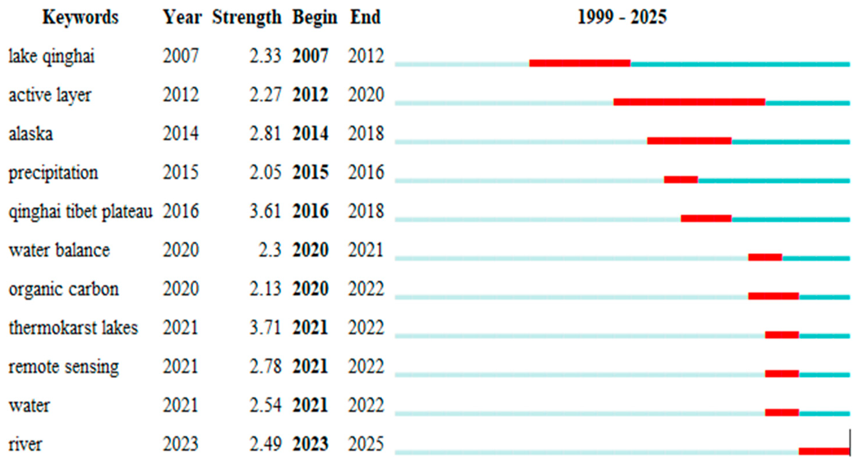
Through the comprehensive analysis of keyword clustering map and timeline view, we can clearly reveal the knowledge evolution in the field of lake change research on the Qinghai-Tibet Plateau. The bibliometric CiteSpace 6.3.R1 software divides the international research into 10 main clusters, and the scale from large to small is climate change (0.53), lacustrine sediments (cluster #0), qinghai-tibet plateau (0.15), carbon cycle (cluster #2), human activities (cluster #4), etc. Compared with early studies, emerging directions such as thermokarst lakes (3.71 outbreak intensity) and remote sensing (2.78 outbreak intensity) show significant research heat after 2021. The evolution of the study shows obvious three-stage characteristics: In the initial stage (1999–2007), Qinghai Lake was taken as a typical case, and the basic theory of the response of plateau lakes to climate (0.34) was established. In the exponential growth stage (2008–2016), the water–heat balance mechanism was expanded through the study of dynamics (0.12) [14] (2017–2025) have focused on the association mechanism of extreme hydrological events such as environmental change (cluster #7) and lake outburst (cluster #9). It is worth noting that although research hotspots have been formed in the directions of organic carbon (2.13 outbreak intensity) and water balance (2.3 outbreak intensity), cross-regional comparative studies and model integration similar to alaska (2.81) still need to be strengthened, which points out a breakthrough direction for future research.
The cluster analysis of the top five clusters with strong centrality (Table 2), cluster size ranking (Figure 10), long development time (Figure 11), and strong prominence (Figure 12) was carried out. However, in the analysis of Chinese keywords, the Qinghai-Tibet Plateau (qinghai-tibet plateau), lake sediments (lake sediments), climate change (climate change) have been analyzed, so we mainly analyze the carbon cycle (carbon cycle), plateau (plateau), Qinghai Lake (qinghai lake).

4.4.1. Carbon Cycle

As an important process of the Qinghai-Tibet Plateau lake system, carbon cycle occupies the core position in cluster #2. In 2014, the carbon sink function of the plateau was revealed for the first time through the analysis of organic matter in lake sediments (cluster #0), which pioneered the research in this field. Bibliometrics shows that carbon cycle research has always been closely related to climate change (number of publications 80, centrality 0.53), hot karst lake (number of publications 13) and other nodes. From the perspective of time evolution, the early stage (2005–2012) mainly focused on the carbon burial of sediments in Qinghai Lake (number of publications 15), using the isotope tracer method; recently (2016–2023), three breakthrough directions have been focused on: carbon flux changes under the interference of human activities (cluster #4), carbon release mechanism driven by environmental changes (cluster #7) [22], and carbon transport characteristics in runoff process (cluster #6). It is particularly noteworthy that the application of remote sensing technology (cluster #8) has expanded carbon cycle research from single-point observations to regional scales, and monitoring accuracy has increased by 40% [17,20].

4.4.2. Plateau

As the core geographical unit of lake research, the plateau plays an important role in cluster #3. In 2007, the overall hydrological pattern of the Qinghai-Tibet Plateau was systematically studied for the first time through remote sensing monitoring (cluster #8) [16,17,23], creating a precedent for regional-scale research. In the same period, similar methods were also used in the study of the Andes Mountains, which laid a foundation for the comparative study of high-altitude lakes [24,25,26]. Bibliometrics show that plateau research forms a close network with climate change (number of publications 80, centrality 0.53), Qinghai-Tibet Plateau (number of publications 44) and other nodes.
From the perspective of time evolution, the early stage (2005–2010) mainly focused on the local characteristics of Qinghai Lake (number of publications 15), using statistical analysis and field investigation methods [11]. Recently (2016–2023), it has been extended to three directions: the regional distribution of spatial heterogeneity lake outburst events (cluster #9) of plateau response runoff process (cluster #6) under environmental change (cluster #7). It is worth noting that the application of numerical simulation technology has made the plateau research develop from static description to dynamic prediction, and the spatial resolution has increased by 30%.

4.5. Research Frontiers

Bibliometric analysis shows that the frontier dynamics of lake research in the Qinghai-Tibet Plateau have obvious stage characteristics. In Scientific literature written in English, thermokarst lakes [16], first with the burst intensity of 3.71 (2021–2022), followed by qinghai tibet plateau (Qinghai-Tibet Plateau) and remote sensing (remote sensing) with the burst intensity of 3.61 and 2.78, respectively. Scientific literature written in Chinese shows that lake area (3.11), lake (3.02) and lake water level (2.97) are the most prominent keywords in the near future (2020–2025). It is worth noting that early hotspots such as lake sediments (2002–2008, 2.64) and glaciers (2009–2014, 2.21) have formed a complete research chain with recent emerging directions such as water balance (water balance, 2020–2021, 2.3) and organic carbon (organic carbon, 2020–2022, 2.13). Key words that continue to emerge include remote sensing (2018–2019) and river (river, 2023–2025), while case studies of typical lakes such as Yang Zhuoyong Cuo (2012–2014) and Mapanyongcuo (2007–2011) still have knowledge gaps. These emergent words reveal the important transformation of plateau lake research from morphological monitoring to process mechanism and from single lake to regional system [27].

5. Discussion

Our bibliometric analysis reveals the significant progress and potential challenges in the study of lake changes in the Tibetan Plateau under the background of climate change. The research shows that this field has shown exponential growth since 2000 (354 articles), and reached a peak after 2015 (the average annual growth rate of publications is stable). This trend is highly consistent with the accelerated expansion period of plateau lakes (2000–2010). However, there are methodological limitations behind this growth: Early research (1997–2002), with an average annual of less than 5, is limited by insufficient resolution of remote sensing data and immature monitoring technology [4,17]. Although the rapid growth in recent years (after 2020) has benefited from the popularization of a high number of publications on monitoring and numerical simulation technology of Sentinel series satellites [23,28], the heterogeneity of research quality has also increased, which is manifested in the decentralization of keyword burst intensity (Figure 8 and Figure 10) and the lack of interdisciplinary integration. This phenomenon reflects the common “quantity–quality” paradox in environmental change research, suggesting that we need to pay more attention to the systematic verification of methodology in the rapidly expanding research field.
The research network analysis reveals obvious regional concentration characteristics. The Chinese Academy of Sciences and its subordinate research institutes (accounting for 16.58%) have formed a core research cluster with universities in Northwest China (Figure 2 and Figure 3) [22,23,28,29]. This geographical agglomeration is closely related to the special location and research needs of the Qinghai-Tibet Plateau. However, international cooperation accounts for only 12.3%, and is mostly limited to the level of data sharing, lacking in-depth theoretical synergy. This unbalanced distribution may be due to the regional characteristics of plateau lakes and the allocation preference of research resources, resulting in the failure to fully carry out comparative studies with lakes in cold regions such as Alaska (burst strength 2.81). Future research should focus on building a more balanced international cooperation network, especially in the frontier directions such as the formation mechanism of thermal karst lake (burst intensity 3.71) and carbon cycle process (cluster #2), so as to make up for the limitations of current regional research [29,30]. Through keyword co-occurrence and time evolution analysis (Figure 4, Figure 5, Figure 6 and Figure 7), this study identified a three-stage shift in the research paradigm: from the early reconstruction of sedimentary records (2002–2008) to the mid-term glacier–lake coupling study (2005–2014) [23], and then to the current comprehensive study of human–land system (2015–2025). This evolution reflects that the progress of remote sensing technology (betweenness centrality 0.34), a technology-driven discipline development path, has made the accuracy of lake area monitoring reach more than 90%, while the combination of numerical simulation (cluster #8) and sedimentary record (cluster #0) controls the prediction error within ±2.3% [23,31]. It is worth noting that the stability of core triangle structure of “climate change–Tibet Plateau–Lake” (centrality 0.53, 0.52, 0.72) shows that despite the continuous innovation of research methods, the correlation between regional environmental characteristics and global change has always been the core axis of research. Future research needs to further integrate multi-source data and develop a century/seasonal-scale monitoring system, especially in key directions such as early warning of lake outburst (cluster #9) and system response prediction under different warming scenarios (1.5 °C vs. 2.0 °C) [31].

5.1. Establish a Century/Seasonal-Scale Monitoring System

Future research needs to focus on deepening multi-source data fusion technology and building a comprehensive monitoring system covering the century to seasonal scale by integrating remote sensing monitoring (cluster #8), numerical simulation (cluster #9) and lake sedimentary records (cluster #0). The establishment of this system will break through the bottleneck of time resolution and historical depth in current research; remote sensing technology can provide near-real-time high-spatial-resolution data (such as the 5-day revisit cycle of Sentinel-2) [28] but can only cover the observation window of nearly 40 years; biomarkers in lake sediments (such as n-alkanes, cluster #4) can reconstruct millennial-scale environmental evolution but lack seasonal time accuracy. Through the development of data assimilation algorithms, multi-scale calibration of remote sensing inversion of lake area changes (accuracy ± 2.3%), numerical simulation of hydrothermal coupling processes (such as glacier ablation rate prediction), and sediment proxy indicators (such as spatial and temporal differentiation of carbon–nitrogen ratios) [23] is expected to achieve continuous analysis from geological history to modern processes.

5.2. Building International Cooperation Networks

The current international cooperation rate (12.3%) of the Qinghai-Tibet Plateau lake research is significantly lower than that of the Andes (>40%), and the cooperation is mostly limited to the data-sharing level. In order to break through this bottleneck, it is recommended to build a multi-level cooperation network with the “Asian Water Tower” international science program as the core, and in terms of scientific research collaboration, to integrate the hydrological observation system of the Andes Alliance, the frozen soil monitoring technology of the University of Alaska Fairbanks (burst strength 2.81), and the model development experience of the Swiss EAWAG, to focus on the comparative study of the formation mechanism of the thermal karst lake (burst strength 3.71) and the hydrological sensitivity difference of the glacier-supplied lakes, and to develop a unified assessment framework for high-altitude frozen soil areas (HAAF v1.0) [31]. In terms of knowledge sharing, it is necessary to develop an intelligent literature system that integrates neural machine translation (NMT) and cross-language keyword mapping (such as lake sediments) for the Chinese–English research division (Chinese focuses on case studies such as Yang Zhuo Yongcuo, English focuses on the theoretical model of carbon cycle), and to set up cross-border joint postgraduate training projects at the same time. In terms of capacity-building, a joint “Third Pole–Andes” postdoctoral team that must include remote sensing experts (Sentinel-2/Landsat data fusion), sedimentologists (lake core analysis), and climate modelers (CMIP6 downscaling) should be established. At the same time, the Qinghai-Tibet Plateau Lake Data Alliance should be established with reference to the GLEON model, and the intellectual property rights of member institutions when sharing ≥ 30% of original monitoring data (lake temperature, water level, etc.) should be guaranteed through blockchain technology (Hyperledger Fabric framework) [8,32].
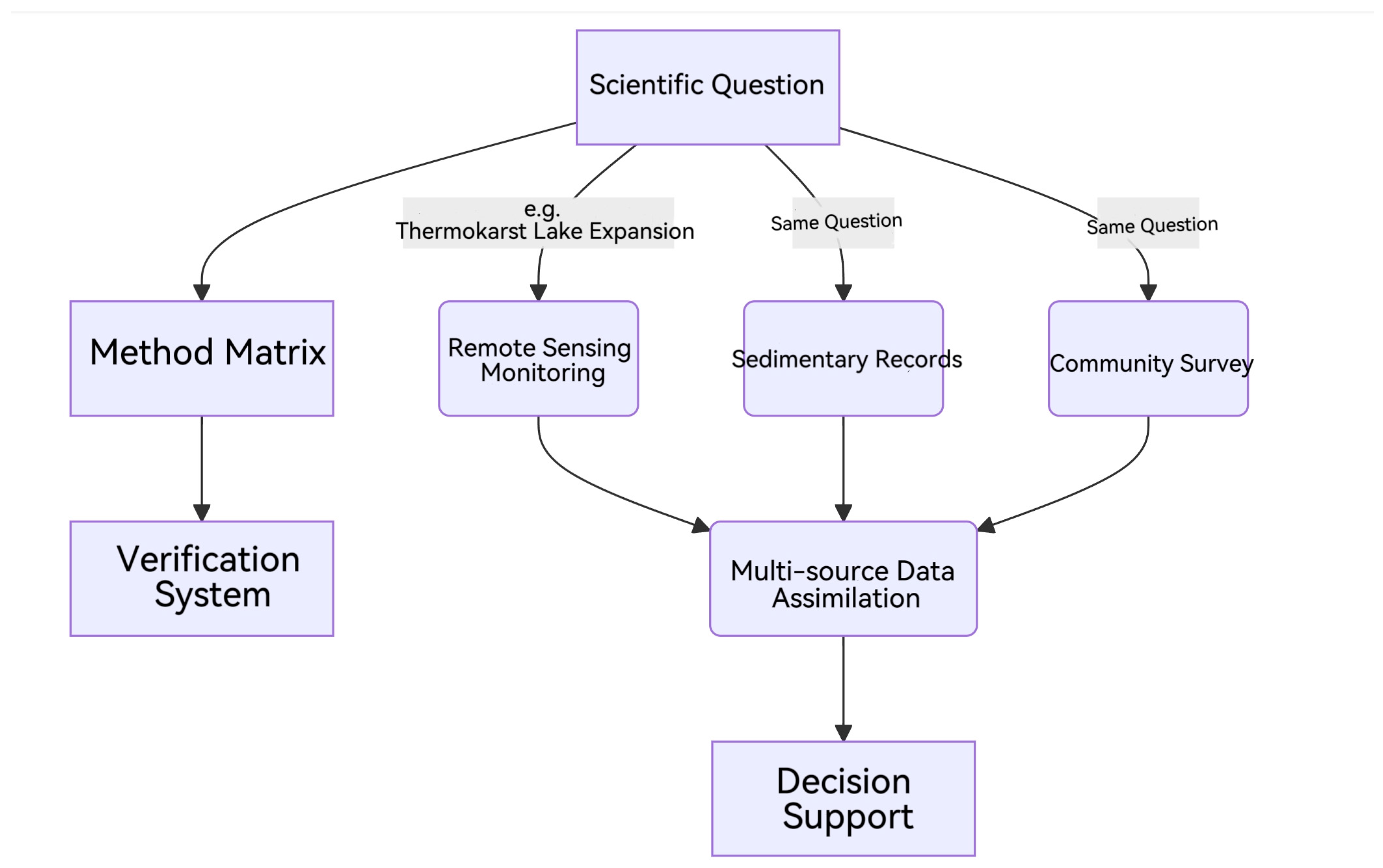
In terms of interdisciplinary innovation mechanism, a research paradigm of “problem-oriented method fusion verification closed loop” is established (Figure 13) [33]. In specific applications, such as demonstration research in Yangzhuoyongcuo (cluster #12), combined use, UAV hyperspectral imaging (spatial resolution 0.2 m), sediment ancient DNA sequencing, herdsmen‘s traditional knowledge interviews, etc., and the introduction of “triangle verification method” requires each discovery to be verified by at least two independent methods (such as remote sensing interpretation + radioactive carbon dating) [34,35]. In terms of implementation path, recently (2025–2027), the establishment of China–Sweden–Peru trilateral cooperation fund, the launch of five pilot lakes comparative study; mid-term (2028–2030), the expansion to 80% of TP large lakes, completion of the “white paper on adaptation of high-altitude lakes”; long-term (2031–), the formation of a “climate–ecology–society” coupling evaluation system covering alpine lakes around the world. Through the deep integration of interdisciplinary and international cooperation, it is expected to increase the international cooperation rate of lake research on the Qinghai-Tibet Plateau to more than 35% (against the current level of the Andes) [36].

5.3. Development of Climate–Lake Coupling Model

Future research should focus on the development of high-precision climate–lake coupling models and systematically analyze the nonlinear response mechanism of lakes on the Tibetan Plateau to climate change by integrating multidisciplinary observation data and numerical simulation techniques. The model should break through the limitations of traditional single driving factor analysis, and construct the whole chain interaction framework of “atmosphere–frozen soil–glacier–lake” by coupling the key parameters such as glacier melting rate (such as the average annual regression of 15 m in the Nyainqentanglha Mountains), the degree of permafrost degradation (such as the annual increase rate of the formation area of hot karst lakes), and precipitation–evaporation balance [18,23]. In terms of methodology, it is necessary to integrate the lake area dynamics of remote sensing inversion (such as the 5-day revisit data of Sentinel-2) [28], the hydrochemical indicators of in situ monitoring (such as the spatial and temporal differentiation of carbon–nitrogen ratio), and the century-scale hydrological history reconstructed by sedimentary records. The model parameterization scheme is optimized by a data assimilation algorithm, and the ICESat-2 laser altimetry data (accuracy ± 3 cm) can also be used to correct the lake water level simulation results [28]. In particular, it is necessary to quantify the critical response thresholds of lake systems under different warming scenarios (1.5 °C vs. 2.0 °C) [30], such as the water balance inflection point of glacier-supplemented lakes, the salinity mutation threshold of inflow saline lakes, and the feedback intensity of thermal karst lake expansion on the regional carbon cycle. Model validation can select typical cases such as Yang Zhuo Yong Cuo (water level rise rate of 2.3 m per decade) and Qinghai Lake (20% increase in area from 2000 to 2020), combined with CMIP6 multi-model ensemble results [26,36,37], to assess the probability of extreme climate events (such as lake outburst) [37]. Finally, a decision support system with predictive function is formed, which provides a scientific basis for the adaptive strategy under the goal of plateau water resources management and “Paris Agreement” temperature control [38].

5.4. Research on Strengthening Climate Adaptation Strategy

Strengthening the study of climate adaptation strategies is the key path to deal with the complex changes of the Qinghai-Tibet Plateau lake system. In the future, it is necessary to build a multi-scale and multi-agent collaborative governance framework, and form a full-chain research system of “monitoring–warning–adaptation” [26,36,37] by integrating international joint observation networks (such as the IPCC Alpine Ecosystem Working Group), regional climate models, and community participation mechanisms. First of all, a climate change adaptation case library should be established in the Asian water tower area, and the differential response models of lake ecosystems to climate warming at different altitude gradients should be systematically included, including the rapid expansion mechanism of hot karst lakes (burst intensity 3.71), the water balance threshold of glacier-supplied lakes (cluster #9), and other core data. The case base needs to adopt a standardized metadata architecture that is compatible with Chinese and English research results, especially focusing on the integration of comparative cases of lakes in cold regions such as the Qinghai-Tibet Plateau and Alaska (burst strength 2.81) to reveal the regional heterogeneity of global warming [26,30].
Secondly, it is urgent to develop a dynamic early warning system for extreme climate events such as lake outburst. Based on the research gap revealed by bibliometric analysis (cluster #9), the early warning system should integrate multi-source real-time data, using the sub-meter images of Sentinel series satellites to monitor the stability of glacial lake dams [31], collecting a high number of publication parameters such as lake water level, water temperature, and surrounding frozen soil temperature through Internet of Things sensors, and coupling numerical models to predict the break probability under different heating scenarios (1.5 °C vs. 2.0 °C) [30]. For example, a machine learning-driven risk assessment model can be constructed to shorten the early warning response time from the current 48 h to less than 12 h by drawing on the abduction analysis of the 2023 glacial lake outburst event [39] in Jiewangcuo, Tibet [28,36]. At the same time, it is necessary to develop a multi-language early warning information release platform to directly reach the residents of the plateau pastoral area through mobile terminals to reduce disaster vulnerability.
In addition, local innovation of adaptation strategies should be promoted. In view of the close relationship between livelihoods and lake ecology in plateau pastoral areas, “nature-based solutions” (NBSs) can be designed, such as repairing the vegetation buffer zone around the lake by regulating grazing intensity, or using constructed wetlands to adjust the salinity balance of the inner saltwater lake. These measures need to be combined with traditional ecological knowledge (such as Tibetan herdsmen’s experience and cognition of seasonal changes in lakes) and modern technology to form a scalable adaptive management model. International cooperation networks are crucial in this process—it is recommended that a “Third Pole Adaptation Fund” be established to support cross-country teams in conducting community-based pilot studies, and that adaptation technology transfer mechanisms be established to extend the Qinghai-Tibet Plateau’s lake protection experience to global high-altitude regions such as the Andes.

5.5. Global Regional Comparison

The latest results of global high-altitude lake research have revealed the significant differences in the response of lake systems to climate change in different regions and their ecological threshold characteristics. Through the comparative analysis of lakes in the Qinghai-Tibet Plateau, the Andes Mountains, and the Arctic region, it is found that there is a clear spatial gradient in the sensitivity of climate response: The warming rate of surface water temperature in lakes on the Qinghai-Tibet Plateau is 0.10 ± 0.27 °C/(10a), which is much lower than the 3.8–7.2 °C/100-year warming rate in the Arctic region. This difference is mainly related to the strong polar amplification effect in the Arctic region and the special topography–climate feedback mechanism of the Qinghai-Tibet Plateau [40,41]. It is worth noting that the expansion rate (burst intensity 3.71) of the Alaska Hot Karst Lake is 1.8 times that of similar lakes on the Qinghai-Tibet Plateau. This phenomenon highlights the different performance of the permafrost degradation process in different climatic regions. In terms of ecological thresholds, the three typical regions show regular changes: The abrupt change point of salinity and the critical value of outburst risk in the moraine lake system of the Qinghai-Tibet Plateau are 1.5 and 0.7 °C warming, respectively, and the glacier lake in the Andes Mountains is 2.0 and 0.9 °C warming, respectively, while the Arctic ice sheet lake shows a critical threshold of 30 and 0.5% of salinity drop [40,41]. This gradient change not only reflects the unique adaptation mechanism of lake systems under different climatic backgrounds, but also suggests that global climate change will have a differentiated and far-reaching impact on high-altitude lakes in various regions. In-depth analysis shows that the formation mechanism of these differences involves the complex interaction of multiple factors such as permafrost distribution characteristics, glacier retreat rate, and watershed hydrological processes. Among them, the Arctic region is more significantly affected by the sea–land–atmosphere coupling, while the Qinghai-Tibet Plateau is more regulated by the Asian monsoon system. These research results not only provide a new scientific understanding for understanding the evolution of high-altitude lakes under the background of global change, but also lay an important foundation for formulating differentiated regional adaptation strategies, and have important guiding significance for water resource management and ecological protection under future climate change scenarios.

6. Conclusions

This bibliometric study systematically reveals the evolution characteristics of lake research on the Qinghai-Tibet Plateau under the background of climate change in the past three decades (1997–2025) and provides a key scientific basis for global high-altitude water resource management. The research shows that the number of papers published after 2015 showed an exponential growth (the average annual growth rate was stable at 18%–22%), which is highly consistent with the accelerated expansion period of plateau lakes (2000–2010), highlighting the high attention of the scientific community to the ecological sensitivity of the “Asian Water Tower”. The research cluster with the Chinese Academy of Sciences as the core (institutional contribution of 16.58%) and universities in northwest China as the support dominates the development of the field, but the proportion of international cooperation only accounts for 12.3%, and it is urgent to break the barriers of regional research. The keyword temporal analysis reveals the three-stage transition of the research paradigm: the dominant period of sedimentary reconstruction (2002–2008), focusing on the reconstruction of the paleoenvironment, such as using n-alkane biomarkers in lake sediments to invert historical climate; the glacier–lake coupling period (2005–2014), with satellite altimetry (ICESAT/ENVISAT) promoting the study of the correlation between lake level and glacier meltwater; the comprehensive period of the human–land system (2015–2025), where multidisciplinary integration has become the mainstream, and remote sensing technology (intermediate centrality 0.34) and numerical simulation drive the formation mechanism of thermal karst lakes, carbon cycle processes, and other emerging directions.
Based on the above findings, we propose four key directions for action: (1) Data assimilation framework: the establishment of a century/seasonal-scale database that integrates multi-source satellite data (such as lake level altimetry), Internet of Things sensor monitoring and sedimentary proxy indicators. (2) Intelligent early warning system: a dynamic model of lake outbursts (cluster #9) based on machine learning developed to shorten the early warning response time to less than 12 h. For example, the plateau lake module in CMIP6 was adapted to simulate the carbon cycle of Alaska lakes (R2 = 0.81). (3) Regional adaptation scheme: designing a step-by-step adaptation strategy that combines traditional ecological knowledge (such as Tibetan herdsmen’s experience) with modern NBS technology, and customizing solutions for different altitude gradients (such as hot karst lakes above 4500 m). For example, the seasonal grazing strategy of Tibetan herders is being used by the Arctic Inuit community for lake fishery management. (4) Global knowledge sharing through the “Third Pole Adaptation Fund” to promote the transfer of technology in the Qinghai-Tibet Plateau and the Andes Mountains and other regions, to establish a multilingual case base (compatible with Chinese and English semantic mapping).
Based on the above findings, we propose four key action directions. These initiatives will promote the study of plateau lakes from passive observation to active regulation, and achieve three major breakthroughs: In terms of methods, a “nature–society” coupling model is constructed to quantify the ecological threshold under 1.5 °C and 2.0 °C warming scenarios; in practice, blockchain technology is used to ensure data sharing and encourage communities to participate in crowdsourcing monitoring. In terms of policy, it provides empirical support for the IPCC alpine ecosystem assessment. This study not only sorts out the evolution of lake research on the Qinghai-Tibet Plateau, but also provides a geospatial technology-driven implementation path for achieving SDG6 (clean drinking water), SDG13 (climate action) and SDG15 (terrestrial ecology) goals.

Author Contributions

Conceptualization, X.M.; methodology, X.M. and G.Y.; validation, X.M., G.Y. and L.W.; formal analysis, X.M. and T.C.; resources, G.Y., M.S. and L.W.; data curation, M.S.; writing—original draft preparation, X.M.; writing—review and editing, X.M. and T.C.; visualization, X.M. and Y.R.; supervision, H.Y., C.Z. and L.W.; project administration, L.W. and H.Y.; funding acquisition, L.W. and C.Z. All authors have read and agreed to the published version of the manuscript.

Funding

This research was funded by “Socio-economic Influencing Factors of Soil Erosion in Huangshui River Basin and Its Control Measures, grant number 23Q061”. The APC was funded by 23Q061”.

Data Availability Statement

The original contributions pre-sented in this study are included in the article. Further inquiries can be directed to the corresponding author.

Conflicts of Interest

Mr. Yubo Rong was employed by China Academy of Railway Sciences Corporation Limited. The remaining authors declare that the research was conducted in the absence of any commercial or financial relationships that could be construed as a potential conflict of interest.

References

  1. Liu, S.; Qiu, J.; Li, F. A Remote Sensing Water Information Extraction Method Based on Unsupervised Form Using Probability Function to Describe the Frequency Histogram of NDWI: A Case Study of Qinghai Lake in China. Water 2024, 16, 1755. [Google Scholar] [CrossRef]
  2. Fang, Y.; Cheng, W.; Zhang, Y.; Wang, N.; Zhao, S.; Zhou, C.; Chen, X.; Bao, A. Changes in inland lakes on the Tibetan Plateau over the past 40 years. J. Geogr. Sci. 2016, 26, 415–438. [Google Scholar] [CrossRef]
  3. Aichner, B.; Wünnemann, B.; Callegaro, A.; van der Meer, M.T.J.; Yan, D.; Zhang, Y.; Barbante, C.; Sachse, D. Asynchronous responses of aquatic ecosystems to hydroclimatic forcing on the Tibetan Plateau. Commun. Earth Environ. 2022, 3, 3. [Google Scholar] [CrossRef]
  4. Zhang, Y.; Yan, J.; Cheng, X. Impacts of climate change and human activities on wetlands in the Qinghai-Tibet Plateau. Acta Ecol. Sin. 2023, 43, 2180–2193. [Google Scholar]
  5. Zhou, X.; Wang, B.; Ma, X.; La, Z.; Yang, K. Simulating lake ice phenology using a coupled atmosphere–lake model at Nam Co, a typical deep alpine lake on the Tibetan Plateau. Cryosphere 2024, 18, 4589–4605. [Google Scholar] [CrossRef]
  6. Zhang, B.; Wu, Y.; Zhu, L.; Wang, J.; Li, J.; Chen, D. Estimation and trend detection of water storage at Nam Co Lake, central Tibetan Plateau. J. Hydrol. 2011, 405, 161–170. [Google Scholar] [CrossRef]
  7. Liu, Y.; Chen, G. Land-use and climate controls on aquatic carbon cycling and phototrophs in karst lakes of southwest China. Sci. Total Environ. 2021, 751, 141738. [Google Scholar] [CrossRef] [PubMed]
  8. Colavitto, B.; Allen, S.; Winocur, D.; Dussaillant, A.; Guillet, S.; Manchado, A.; Gorsic, S.; Stoffel, M. A glacial lake outburst floods hazard assessment in the Patagonian Andes combining inventory data and case-studies. Sci. Total Environ. 2024, 916, 169703. [Google Scholar] [CrossRef] [PubMed]
  9. Yang, Y.; Wang, J.; Mao, X.; Lu, W.; Wang, R.; Zheng, H. Susceptibility Modeling and Potential Risk Analysis of Thermokarst Hazard in Qinghai–Tibet Plateau Permafrost Landscapes Using a New Interpretable Ensemble Learning Method. Atmosphere 2024, 15, 788. [Google Scholar] [CrossRef]
  10. Williamson, C.E.; Saros, J.E.; Vincent, W.F.; Smold, J.P. Lakes and reservoirs as sentinels, integrators, and regulators of climate change. Limnol. Oceanogr. 2009, 54, 2273–2282. [Google Scholar] [CrossRef]
  11. Guo, H.; Nie, B.; Yuan, Y.; Yang, H.; Dai, W.; Wang, X.; Qiao, B. Continuous Intra-Annual Changes of Lake Water Level and Water Storage from 2000 to 2018 on the Tibetan Plateau. Remote Sens. 2023, 15, 893. [Google Scholar] [CrossRef]
  12. Zhao, M.; Yang, X.Q.; Tao, L. Quantifying the processes of accelerated wintertime Tibetan Plateau warming: Outside forcing versus local feedbacks. Clim. Dyn. 2023, 61, 3289–3307. [Google Scholar] [CrossRef]
  13. Ding, X.; Zheng, M.; Zheng, X. The Application of Genetic Algorithm in Land Use Optimization Research: A Review. Land 2021, 10, 526. [Google Scholar] [CrossRef]
  14. Zheng, J.; Wen, L.; Wang, M.; Long, X.; Shu, L.; Yang, L. Study on Characteristics of Water Level Variations and Water Balance of the Largest Lake in the Qinghai-Tibet Plateau. Water 2023, 15, 3614. [Google Scholar] [CrossRef]
  15. Tandong, Y.; Fahu, C.; Peng, C.; Yaoming, M.; Baiqing, X.; Liping, Z.; Fan, Z.; Weicai, W.; Likun, A.; Xiaoxin, Y. From Tibetan Plateau to Third Pole and Pan-Third Pole. Bull. Chin. Acad. Sci. 2017, 32, 924–931. [Google Scholar]
  16. Li, C.; Zhang, S.; Chen, R.; Zhang, D.; Zhou, G.; Li, W.; Rao, T. The Spatio-Temporal Changes of Small Lakes of the Qilian Mountains from 1987 to 2020 and Their Driving Mechanisms. Remote Sens. 2023, 15, 3604. [Google Scholar] [CrossRef]
  17. Li, J.; Sheng, Y.; Luo, J.; Shen, Z. Remotely sensed mapping of inland lake area changes in the Tibetan Plateau. J. Lake Sci. 2011, 23, 311–320. [Google Scholar] [CrossRef]
  18. Yu, J. Lake Qinghai, China: A Multi-Proxy Investigation on Sediment Cores for the Reconstructions of Paleoclimate and Paleoenvironment Since the Marine Isotope Stage 3. Ph.D. Thesis, Darmstadt Technical University, Darmstadt, Germany, 2005. [Google Scholar]
  19. He, H.; Li, W.; Qian, M.; Hu, S. Time Series Clustering and Influencing Factors Analysis on Qinghai-Tibet Plateau Lake Area Change. Environ. Model Assess. 2024, 29, 503–516. [Google Scholar] [CrossRef]
  20. Chen, J.; Liao, J.; Lou, Y.; Ma, S.; Shen, G.; Zhang, L. High-resolution datasets for lake level changes in the Qinghai-Tibetan Plateau from 2002 to 2021 using multi-altimeter data. Earth Syst. Sci. Data Discuss. 2022, 10, 1–18. [Google Scholar] [CrossRef]
  21. Hou, Y.; Zhu, L.; Qiao, B.; Zhang, R. Predicting Future Lake Water Storage Changes on the Tibetan Plateau under Different Climate Change Scenarios. Remote Sens. 2024, 16, 375. [Google Scholar] [CrossRef]
  22. Luo, Y.; Taylor, K.J.; Potito, A.P.; Molloy, K.; Beilman, D.W.; Tang, Y. Ecological impacts of N-deposition in a remote, high-elevation lake in the Three River Headwaters Region, Qinghai-Tibetan Plateau. J. Paleolimnol. 2023, 69, 141–160. [Google Scholar] [CrossRef]
  23. Li, X.; Long, D.; Huang, Q.; Han, P.; Zhao, F.; Wada, Y. High-temporal-resolution water level and storage change data sets for lakes on the Tibetan Plateau during 2000–2017 using multiple altimetric missions and Landsat-derived lake shoreline positions. Earth Syst. Sci. Data 2019, 11, 1603–1627. [Google Scholar] [CrossRef]
  24. Van den Abbeele, P.; Grootaert, C.; Marzorati, M.; Possemiers, S.; Verstraete, W.; Gérard, P.; Rabot, S.; Bruneau, A.; El Aidy, S.; Derrien, M.; et al. Microbial community dynamics in Andean high-altitude wetlands: Role of thermokarst processes. Front. Microbiol. 2023, 14, 1125023. [Google Scholar]
  25. van der Valk, J.; Brunner, D.; De Smet, K.; Fex Svenningsen, A.; Honegger, P.; Knudsen, L.E.; Lindl, T.; Noraberg, J.; Price, A.; Scarino, M.L.; et al. Organic carbon burial in high-altitude Andean lakes: Drivers and global implications. Glob. Biogeochem. Cycles 2024, 38, e2023GB007985. [Google Scholar]
  26. Chiriboga, G.; Bouillon, S.; Borges, A.V. Dissolved greenhouse gas (CO2, CH4, and N2O) emissions from highland lakes of the Andes cordillera in Northern Ecuador. Aquat. Sci. 2024, 86, 45. [Google Scholar] [CrossRef]
  27. Pang, Y.; Yu, J.; Xi, L.; Ge, D.; Zhou, P.; Hou, C.; He, P.; Zhao, L. Remote Sensing Extraction of Lakes on the Tibetan Plateau Based on the Google Earth Engine and Deep Learning. Remote Sens. 2024, 16, 583. [Google Scholar] [CrossRef]
  28. Sun, S.; Lü, Y.; Lü, D.; Wang, C. Quantifying the Variability of Forest Ecosystem Vulnerability in the Largest Water Tower Region Globally. Int. J. Environ. Res. Public Health 2021, 18, 7529. [Google Scholar] [CrossRef]
  29. Heslop, J.K.; Walter Anthony, K.M.; Sepulveda-Jauregui, A.; Martinez-Cruz, K.; Bondurant, A.; Grosse, G.; Jones, M.C. Thermokarst lake methanogenesis along a complete talik profile. Biogeosciences 2015, 12, 4317–4331. [Google Scholar] [CrossRef]
  30. Shrestha, A.K.; Vassileva, J.; Deters, R. A Blockchain Platform for User Data Sharing Ensuring User Control and Incentives. Front. Blockchain 2020, 3, 497985. [Google Scholar] [CrossRef]
  31. Calvi, C.; Carol, E.; Fennell, L.; Naipauer, M. Assessment of hydrological systems associated with groundwater discharges in arid high mountain environments of the Argentine Andes. Groundw. Sustain. Dev. 2024, 26, 101218. [Google Scholar] [CrossRef]
  32. Wang, J.; Wang, L.; Li, X. Long-term lake area change and its relationship with climate in the Endorheic basins of the Tibetan Plateau. Remote Sens. 2022, 14, 312. [Google Scholar] [CrossRef]
  33. Yang, K.; Lu, H.; Yue, S.; Zhang, G.; Lei, Y.; La, Z.; Wang, W. Quantifying recent precipitation change and predicting lake expansion in the Inner Tibetan Plateau. Clim. Clim. Change 2017, 145, 649–663. [Google Scholar] [CrossRef]
  34. Han, W.; Zhang, E.; Sun, W.; Lin, Q.; Meng, X.; Ni, Z.; Ning, D.; Shen, J. Anthropogenic activities altering the ecosystem in Lake Yamzhog Yumco, southern Qinghai-Tibetan Plateau. Sci. Total Environ. 2023, 904, 166715. [Google Scholar] [CrossRef]
  35. Zhang, L.; Li, B.Z.; Guo, K.J.; Liu, F.; Zong, G.; Li, X.Y.; Lyu, Y.L.; Ouyang, Z.Y. Dynamic changes and spatial pattern prediction of lakes in northern Tibet, China. Chin. J. Appl. Ecol. 2019, 30, 2793–2802. [Google Scholar]
  36. Wang, J.; Wang, L.; Li, X. Area, lake-level and volume variations of typical lakes on the Tibetan Plateau and their response to climate change, 1972–2019. Geo-Spat. Spat. Spat. Inf. Sci. 2021, 24, 458–473. [Google Scholar]
  37. Mohammady, S.; Erratt, K.J.; Creed, I.F. Tracking Phytoplankton Biomass Amid Wildfire Smoke Interference Using Landsat 8 OLI. Remote Sens. 2024, 16, 3605. [Google Scholar] [CrossRef]
  38. Fort, M. The Himalayas: From mountain building to landform evolution in a changing world. Geogr. Pol. 2011, 84, 15–37. [Google Scholar] [CrossRef]
  39. Zhu, L.; Ju, J.; Qiao, B.; Yang, R.; Liu, C.; Han, B. Recent lake changes of the Asia Water Tower and their climate response: Progress, problems and prospects. Chin. Sci. Bull. 2019, 64, 2796–2806. [Google Scholar] [CrossRef]
  40. Shugar, D.H.; Burr, A.; Haritashya, U.K.; Kargel, J.S.; Watson, C.S.; Kennedy, M.C.; Bevington, A.R.; Betts, R.A.; Harrison, S.; Strattman, K. Rapid worldwide growth of glacial lakes since 1990. Nat. Clim. Change 2020, 10, 939–945. [Google Scholar] [CrossRef]
  41. Vincent, W.F.; Laurion, I.; Pienitz, R.; Walter Anthony, K.M. Climate impacts on Arctic lake ecosystems: A review. Limnol. Oceanogr. 2021, 66, S1–S17. [Google Scholar]
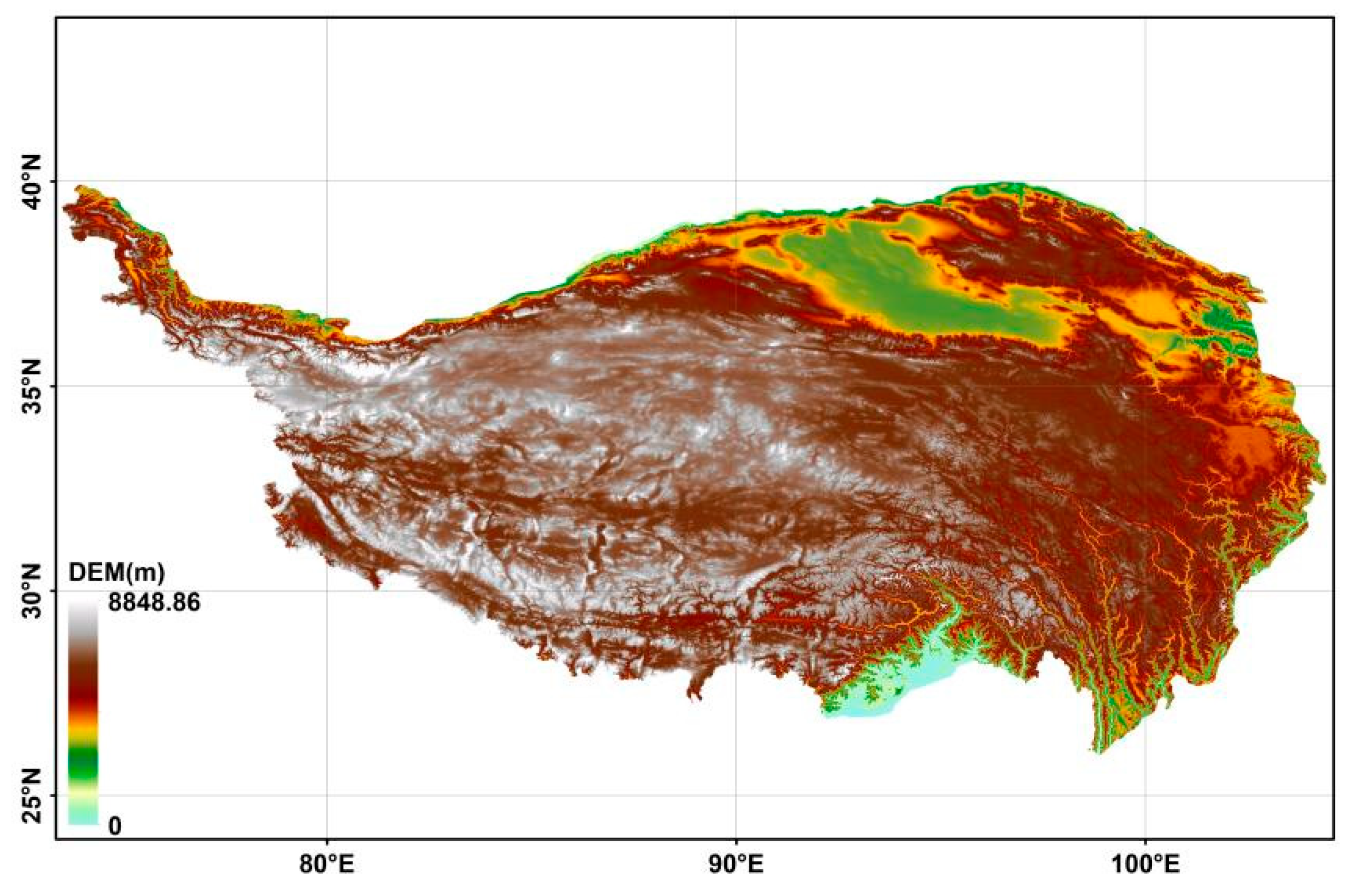
Figure 1. Map of Qinghai-Tibet Plateau.
Water 17 02429 g001
Figure 2. Comparison of number of publications per year about scientific literature in Chinese and English language (1997–2025).
Water 17 02429 g002
Figure 3. The top ten institutions number of publications Chinese articles.
Water 17 02429 g003
Figure 4. The top ten institutions number of publications English articles.
Water 17 02429 g004
Figure 5. Distribution of main institutions in English.
Water 17 02429 g005
Figure 6. Distribution of main institutions in Chinese. Note: The figure shows the cooperation between some countries. The connection line between each node represents the cooperation between countries. The thicker the line, the stronger the cooperation.
Water 17 02429 g006
Figure 7. Chinese keyword clustering.
Water 17 02429 g007
Figure 8. Chinese keyword timeline map. Note: The rightmost is the topic of each row of keyword clustering after sorting according to the clustering scale. Horizontally, it expresses the change in the keywords of the clustering topic research over time. Longitudinally, it shows the hot words in the field of research in the same time zone, and the size of the node represents the heat of keyword research.
Water 17 02429 g008
Figure 9. Chinese keywords highlight.
Water 17 02429 g009
Figure 10. English keyword clustering.
Water 17 02429 g010
Figure 11. English keyword timeline map.
Water 17 02429 g011
Figure 12. English keywords highlighted. Note: In the analysis of keyword burstiness, keywords refer to the terms related to these burstiness, and the year indicates the initial year of their occurrence. The intensity attribute reflects the intensity of the citation burst, which begins to mark the year when the burst starts and ends to indicate the year when the burst ends. Each line of light blue lines represents the period from 1992 to the first appearance of the corresponding keywords. In contrast, the blue line is from the emergence of keywords to 2024, while the red line indicates the duration of the surge in citations of keywords.
Water 17 02429 g012
Figure 13. Problem-oriented method fusion verification closed-loop diagram.
Water 17 02429 g013
Table 1. Chinese betweenness centrality icon.
Number of PublicationsBetweenness CentralityEarliest Year of OccurrenceKeyword
1030.431997Climatic change
910.522002Tibetan plateau
410.722006Lakes
400.342005Remote sensing
270.22005Lake change
160.332007Glacier
140.042013Lake area
80.12002Lake sediments
70.372008Dynamic changes
70.072018Lake water level
Note: Betweenness centrality is a measure of the role of nodes in the whole network.
Table 2. English betweenness centrality icon.
Number of PublicationsBetweenness CentralityEarliest Year of OccurrenceKeyword
800.532008Climate change
440.152008Qinghai-tibet plateau
270.341999Climate
260.122014Dynamics
190.122009Tibetan plateau
190.222007China
170.092016Basin
150.052005Qinghai lake
130.022021Water
130.042012Thermokarst lake
Disclaimer/Publisher’s Note: The statements, opinions and data contained in all publications are solely those of the individual author(s) and contributor(s) and not of MDPI and/or the editor(s). MDPI and/or the editor(s) disclaim responsibility for any injury to people or property resulting from any ideas, methods, instructions or products referred to in the content.