Mapping Wet Areas and Drainage Networks of Data-Scarce Catchments Using Topographic Attributes
Abstract
1. Introduction
1.1. Wet Areas
1.2. Stream Initiation
2. Materials and Prediction Models
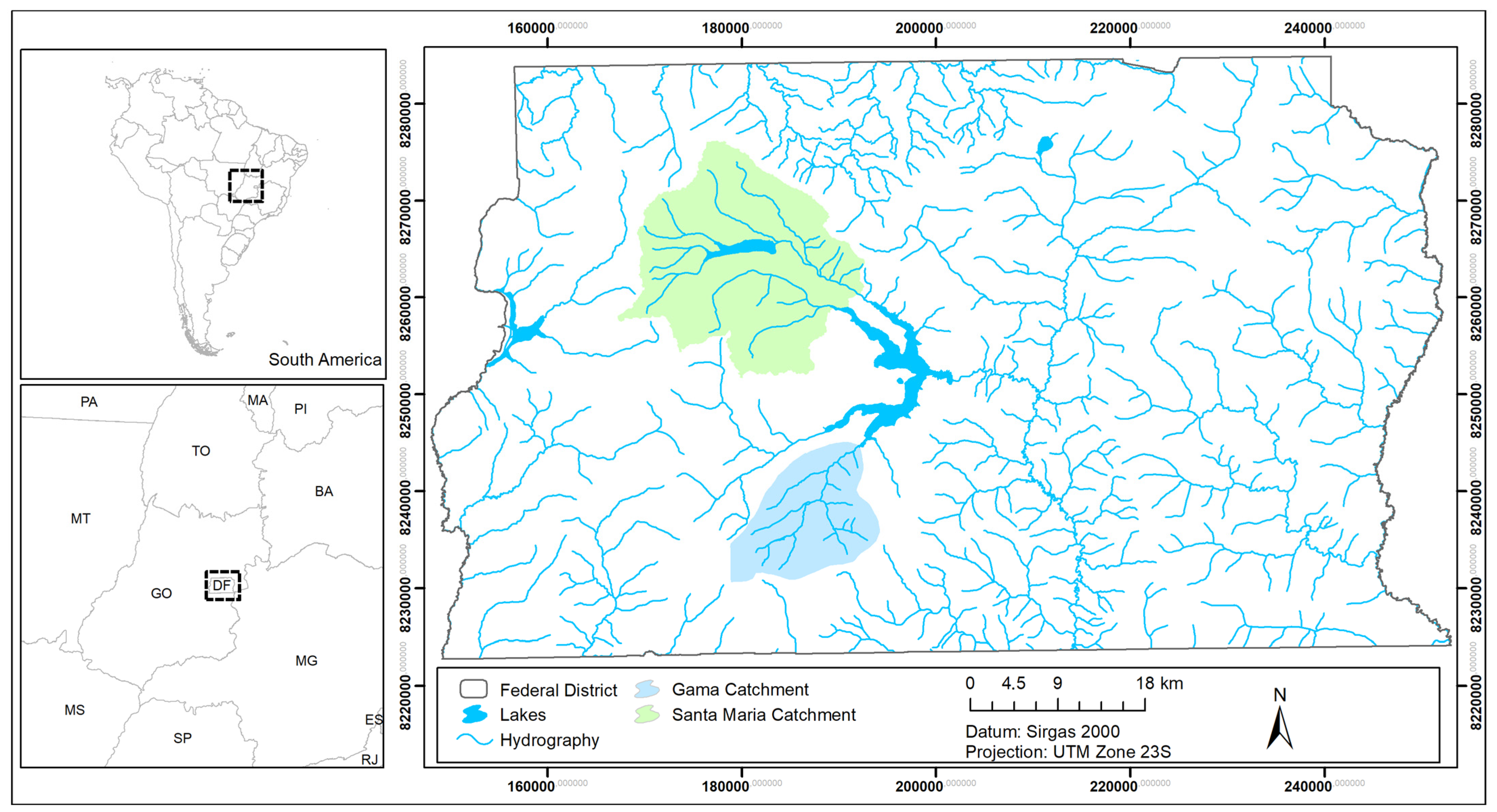
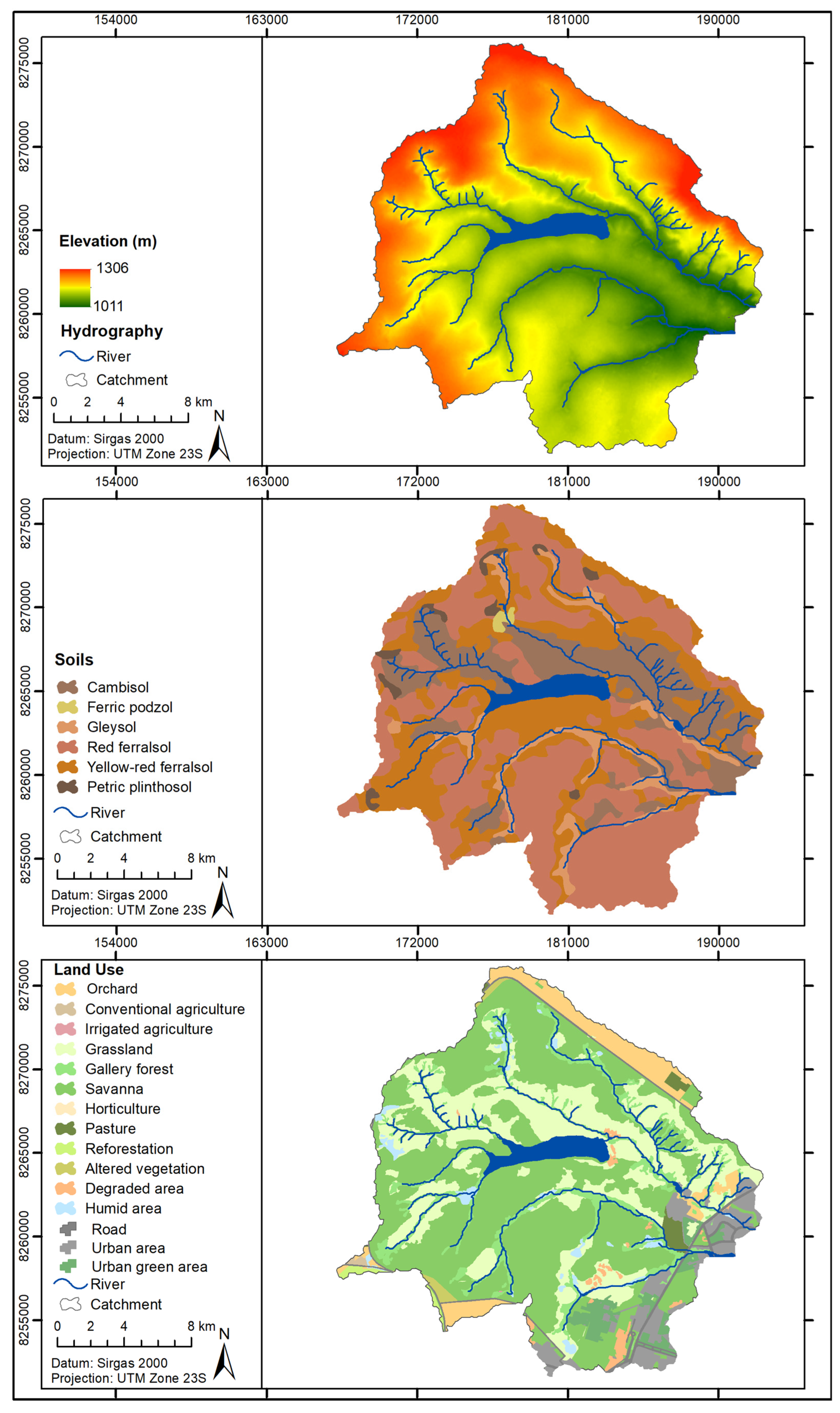
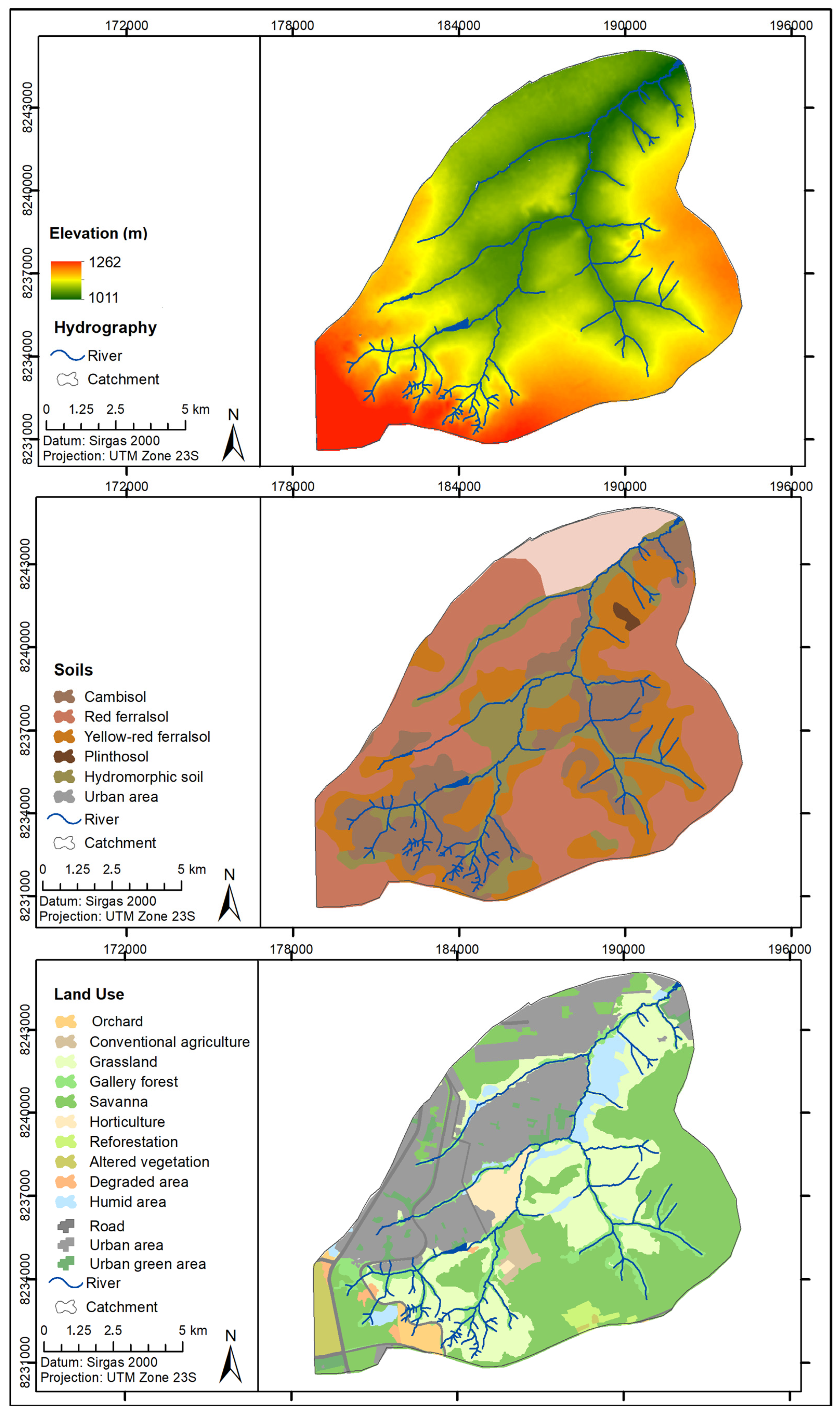
2.1. Study Area
2.2. Selected Topographic Attributes
2.3. Drainage Network Delineation
2.4. Wet Area Delineation
3. Results
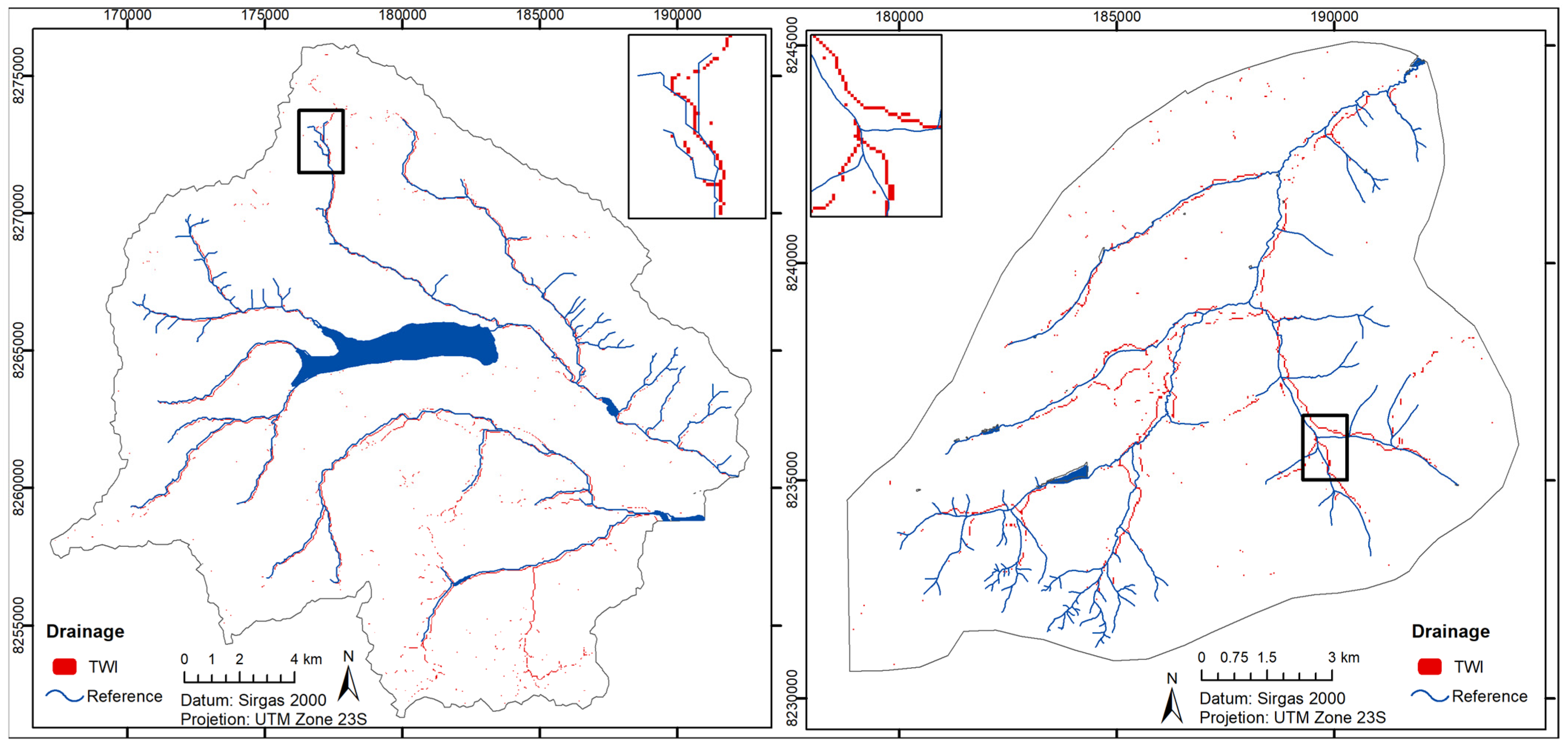
3.1. Drainage Network Delineation
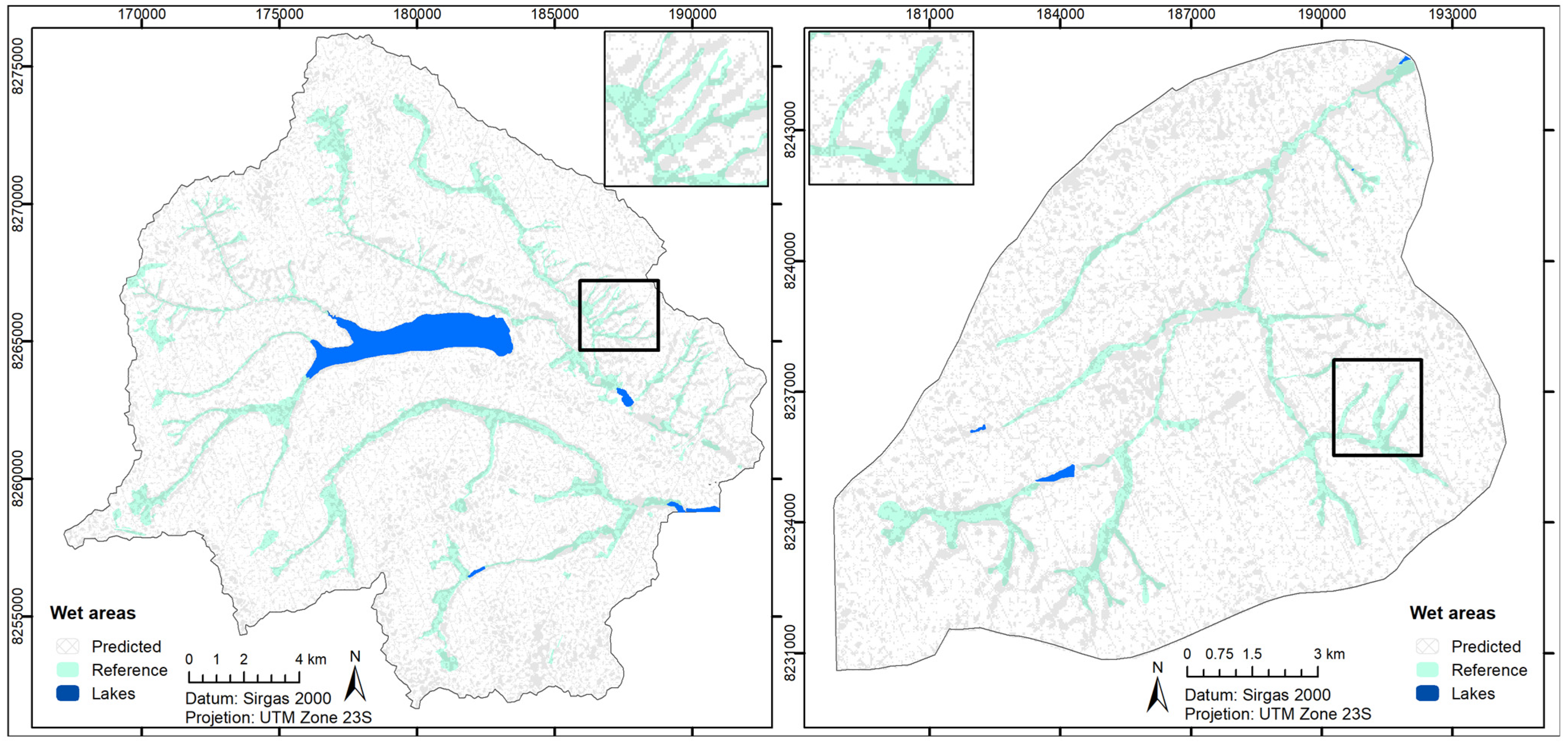
3.2. Wet Area Delineation
4. Discussion
4.1. Drainage Network Delineation
4.2. Wet Area Delineation
5. Conclusions
Author Contributions
Funding
Data Availability Statement
Acknowledgments
Conflicts of Interest
References
- Laudon, H.; Kuglerová, L.; Sponseller, M.F.; Nordin, A.; Bishop, K.; Lundmark, T.; Egnell, G.; Anneli, A. The Role of Biogeochemical Hotspots, Landscape Heterogeneity, and Hydrological Connectivity for Minimizing Forestry Effects on Water Quality. Ambio 2016, 45, S152–S162. [Google Scholar] [CrossRef]
- Tomer, M.D.; Dosskey, M.G.; Burkart, M.R.; James, D.E.; Helmers, M.J.; Eisenhauer, D.E. Methods to Prioritize Placement of Riparian Buffers for Improved Water Quality. Agrofor. Syst. 2009, 75, 17–25. [Google Scholar] [CrossRef]
- Johnson, M.A.; Saraiva, P.M.; Coelho, D. The Role of Gallery Forests in the Distribution of Cerrado Mammals. Rev. Bras. Biol. 1999, 59, 421–427. [Google Scholar] [CrossRef]
- Skorupa, A.L.A.; Fay, M.; Zinn, Y.L.; Scheuber, M. Assessing Hydric Soils in a Gallery Forest in the Brazilian Cerrado. Soil Use Manag. 2013, 29, 119–129. [Google Scholar] [CrossRef]
- Eiten, G. The Cerrado Vegetation of Brazil. Bot. Rev. 1972, 38, 201–341. [Google Scholar] [CrossRef]
- De Oliveira-Filho, A.T.; Shepherd, G.J.; Martins, F.R.; Stubblebine, W.H. Environmental Factors Affecting Physiognomic and Floristic Variation in an Area of Cerrado in Central Brazil. J. Trop. Ecol. 1989, 5, 413–431. [Google Scholar] [CrossRef]
- Johnston, R.; Cools, J.; Liersch, S.; Morardet, S.; Murgue, C.; Mahieu, M.; Zsuffa, I.; Uyttendaele, G.P. WETwin: A Structured Approach to Evaluating Wetland Management Options in Data-Poor Contexts. Environ. Sci. Policy 2013, 34, 3–17. [Google Scholar] [CrossRef]
- Anaya-Acevedo, J.A.; Escobar-Martínez, J.F.; Massone, H.; Booman, G.; Quiroz-Londoño, O.M.; Cañón-Barriga, C.C.; Montoya-Jaramillo, L.J.; Palomino-Ángel, S. Identificación de Áreas de Humedal En El Contexto Del Desarrollo Agrícola Usando Teledetección y SIG. DYNA 2017, 84, 186–194. [Google Scholar] [CrossRef]
- Güntner, A.; Seibert, J.; Uhlenbrook, S. Modeling Spatial Patterns of Saturated Areas: An Evaluation of Different Terrain Indices. Water Resour. Res. 2004, 40, 1–19. [Google Scholar] [CrossRef]
- Lenza, E.; Santos, J.O.; Maracahipes-Santos, L. Species Composition, Diversity, and Vegetation Structure in a Gallery Forest-Cerrado Sensu Stricto Transition Zone in Eastern Mato Grosso, Brazil. Acta Bot. Bras. 2015, 29, 327–338. [Google Scholar] [CrossRef]
- Dunne, T. Formation and Controls of Channel Networks. Prog. Phys. Geogr. 1980, 4, 28. [Google Scholar] [CrossRef]
- Hastings, B.E.; Kampf, S.K. Evaluation of Digital Channel Network Derivation Methods in a Glaciated Subalpine Catchment. Earth Surf. Process. Landf. 2014, 39, 1790–1802. [Google Scholar] [CrossRef]
- O’Loughlin, E.M.O.; Resources, L. Natural Catchments by Topographic Analysis Net Drainage Flu x q • i •••. Water Resour. 1986, 22, 794–804. [Google Scholar]
- Moore, I.D.; Burch, G.J.; Mackenzie, D.H. Topographic Effects on the Distribution of Surface Soil Water and the Location of Ephemeral Gullies. Trans. Am. Soc. Agric. Eng. 1988, 31, 1098–1107. [Google Scholar] [CrossRef]
- Moore, I.D.; Grayson, R.B.; Ladson, A.R. Digital Terrain Modelling: A Review of Hydrological, Geomorphological, and Biological Applications. Hydrol. Process. 1991, 5, 3–30. [Google Scholar] [CrossRef]
- Detty, J.M.; McGuire, K.J. Topographic Controls on Shallow Groundwater Dynamics: Implications of Hydrologic Connectivity between Hillslopes and Riparian Zones in a till Mantled Catchment. Hydrol. Process. 2010, 24, 2222–2236. [Google Scholar] [CrossRef]
- Beven, K.J.; Kirkby, M.J. A Physically Based, Variable Contributing Area Model of Basin Hydrology. Hydrol. Sci. Bull. 1979, 24, 43–69. [Google Scholar] [CrossRef]
- Burt, T.P.; Butcher, D.P. Topographic Controls of Soil Moisture Distributions. J. Soil. Sci. 1985, 36, 469–486. [Google Scholar] [CrossRef]
- Buchanan, B.P.; Fleming, M.; Schneider, R.L.; Richards, B.K.; Archibald, J.; Qiu, Z.; Walter, M.T. Evaluating Topographic Wetness Indices across Central New York Agricultural Landscapes. Hydrol. Earth Syst. Sci. 2014, 18, 3279–3299. [Google Scholar] [CrossRef]
- Güntner, A.; Krol, M.S.; Araújo, J.C.D.; Bronstert, A. Simple Water Balance Modelling of Surface Reservoir Systems in a Large Data-Scarce Semiarid Region/Modélisation Simple Du Bilan Hydrologique de Systèmes de Réservoirs de Surface Dans Une Grande Région Semi-Aride Pauvre En Données. Hydrol. Sci. J. 2004, 49, 901–918. [Google Scholar] [CrossRef]
- Grabs, T.; Seibert, J.; Bishop, K.; Laudon, H. Modeling Spatial Patterns of Saturated Areas: A Comparison of the Topographic Wetness Index and a Dynamic Distributed Model. J. Hydrol. 2009, 373, 15–23. [Google Scholar] [CrossRef]
- Chang, C.-H.; Lee, K.T. Analysis of Geomorphologic and Hydrological Characteristcs in Watershed Saturated Areas Using Topographic-Index Threshold and Geomorphology-Based Runoff Model. Hydrol. Process. 2008, 22, 802–812. [Google Scholar] [CrossRef]
- Qin, C.Z.; Zhu, A.X.; Pei, T.; Li, B.L.; Scholten, T.; Behrens, T.; Zhou, C.H. An Approach to Computing Topographic Wetness Index Based on Maximum Downslope Gradient. Precis. Agric. 2011, 12, 32–43. [Google Scholar] [CrossRef]
- Ali, G.; Birkel, C.; Tetzlaff, D.; Soulsby, C.; Mcdonnell, J.J.; Tarolli, P. A Comparison of Wetness Indices for the Prediction of Observed Connected Saturated Areas under Contrasting Conditions. Earth Surf. Process. Landf. 2014, 39, 399–413. [Google Scholar] [CrossRef]
- Silva, B.P.C.; Naves Silva, M.L.; Avalos, F.A.P.; Duarte de Menezes, M.; Curi, N. Author Correction: Digital Soil Mapping Including Additional Point Sampling in Posses Ecosystem Services Pilot Watershed, Southeastern Brazil. Sci. Rep. 2019, 9, 16147. [Google Scholar] [CrossRef]
- Marimon, B.S.; Felfili, J.M.; Lima, E.D.S.; Duarte, W.M.G.; Marimon-Júnior, B.H. Environmental Determinants for Natural Regeneration of Gallery Forest at the Cerrado/Amazonia Boundaries in Brazil. Acta Amaz. 2010, 40, 107–118. [Google Scholar] [CrossRef]
- Roth, G.; La Barbera, P. Morphological Characterization of Channel Initiation. Phys. Chem. Earth 1997, 22, 329–332. [Google Scholar] [CrossRef]
- Julian, J.P.; Elmore, A.J.; Guinn, S.M. Channel Head Locations in Forested Watersheds across the Mid-Atlantic United States: A Physiographic Analysis. Geomorphology 2012, 177–178, 194–203. [Google Scholar] [CrossRef]
- Montgomery, D.R.; Dietrich, W.E. Channel Initiation and the Problem of Landscape Scale. Science 1992, 255, 826–830. [Google Scholar] [CrossRef]
- Gallon, E.; Lindberg, S. Where Does the Stream Begin? Stream Initiation under Variable Wetness Conditions in a Boreal Landscape; Självständigt Arb.: Upsalla, Sweden, 2014; 34p. [Google Scholar]
- Henkle, J.E.; Wohl, E.; Beckman, N. Locations of Channel Heads in the Semiarid Colorado Front Range, USA. Geomorphology 2011, 129, 309–319. [Google Scholar] [CrossRef]
- Jaeger, K.L.; Montgomery, D.R.; Bolton, S.M. Channel and Perennial Flow Initiation in Headwater Streams: Management Implications of Variability in Source-Area Size. Environ. Manag. 2007, 40, 775–786. [Google Scholar] [CrossRef] [PubMed]
- Montgomery, D.R.; Dietrich, W.E. Source Areas, Drainage Density, and Channel Initiation. Water Resour. Res. 1989, 25, 1907–1918. [Google Scholar] [CrossRef]
- Quinn, P.F.; Beven, K.J.; Lamb, R. The in(a/Tan/β) Index: How to Calculate It and How to Use It within the Topmodel Framework. Hydrol. Process. 1995, 9, 161–182. [Google Scholar] [CrossRef]
- Kim, S.; Lee, H. A Digital Elevation Analysis: A Spatially Distributed Flow Apportioning Algorithm. Hydrol. Process. 2004, 18, 1777–1794. [Google Scholar] [CrossRef]
- McMaster, K.J. Effects of Digital Elevation Model Resolution on Derived Stream Network Positions. Water Resour. Res. 2002, 38, 13-1–13-18. [Google Scholar] [CrossRef]
- Ruhoff, A.L.; Castro, N.M.R.; Risso, A. Numerical Modelling of the Topographic Wetness Index: An Analysis at Different Scales. Int. J. Geosci. 2011, 2, 476–483. [Google Scholar] [CrossRef]
- Unesco. Vegetação No Distrito Federal: Tempo e Espaço. In Uma Avaliação Multitemporal Da Perda de Cobertura Vegetal No DF e Da Diversidade Florística Da Reserva Da Biosfera Do Cerrado—Fase I, 2nd ed.; UNESCO: Brasilia, Brazil, 2002; ISBN 8587853716. [Google Scholar]
- Schneiderman, E.M.; Steenhuis, T.S.; Thongs, D.J.; Easton, Z.M.; Zion, M.S.; Neal, A.L.; Mendoza, G.F.; Walter, M.T. Incorporating Variable Source Area Hydrology into a Curve-Number-Based Watershed Model. Hydrol. Process. 2007, 21, 3420–3430. [Google Scholar] [CrossRef]
- O’Neill, M.P.; Schmidt, J.C.; Dobrowolski, J.P.; Hawkins, C.P.; Neale, C.M.U. Identifying Sites for Riparian Wetland Restoration: Application of a Model to the Upper Arkansas River Basin. Restor. Ecol. 1997, 5, 85–102. [Google Scholar] [CrossRef]
- Jenson, S.K.; Domingue, J.O. Extracting Topographic Structure from Digital Elevation Data for Geographic Information System Analysis. Photogramm. Eng. Remote Sens. 1988, 54, 1593–1600. [Google Scholar]
- Valeriano, M.; Rossetti, D.; Albuquerque, P.C.G. Topodata: Desenvolvimento Da Primeira Versão Do Banco de Dados Geomorfométricos Locais Em Cobertura Nacional. In Proceedings of the Anais XIV Simpdzsio Brasileiro de Sensoriamento Remoto, Natal, Brazil, 25–30 April 2009; pp. 5499–5506. [Google Scholar]
- Russell, G.D.; Hawkins, C.P.; O’Neill, M.P. The Role of GIS in Selecting Sites for Riparian Restoration Based on Hydrology and Land Use. Restor. Ecol. 1997, 5, 56–68. [Google Scholar] [CrossRef]
- Rinderer, M.; van Meerveld, H.J.; Seibert, J. Topographic Controls on Shallow Groundwater Levels in a Steep, Prealpine Catchment: When Are the TWI Assumpitions Valid? Water Resour. Res. 2014, 50, 6067–6080. [Google Scholar] [CrossRef]
- Ågren, A.M.; Lidberg, W.; Strömgren, M.; Ogilvie, J.; Arp, P.A. Evaluating Digital Terrain Indices for Soil Wetness Mapping—A Swedish Case Study. Hydrol. Earth Syst. Sci. 2014, 18, 3623–3634. [Google Scholar] [CrossRef]
- Dewitte, O.; Daoudi, M.; Bosco, C.; Van Den Eeckhaut, M. Predicting the Susceptibility to Gully Initiation in Data-Poor Regions. Geomorphology 2015, 228, 101–115. [Google Scholar] [CrossRef]
- Capoane, V.; Tiecher, T.; Rasche Alvarez, J.W.R.; Pellegrini, A.; Schaefer, G.L.; Santos, L.J.C.; dos Santos, D.R. Influência Da Resolução Do Modelo Digital de Elevação Na Determinação Do Índice Topográfico de Umidade e Na Capacidade de Predição Dos Teores Carbono Orgânico Do Solo. Geo UERJ 2015, 27, 144–155. [Google Scholar] [CrossRef][Green Version]
- Orlandi, A.G.; de Carvalho Júnior, O.A.; Guimarães, R.F.; de Souza Bias, E.; Corrêa, D.C.; Gomes, R.A.T. Vertical Accuracy Assessment of the Processed SRTM Data for the Brazilian Territory. Bol. Ciênc. Geod. 2019, 25, e2019021. [Google Scholar] [CrossRef]


| Catchment | Area (km2) | Hmin (m) | Hmax (m) | Slope (%) | Dd (km−1) | Cr | O | P (mm) | Q (mm) |
|---|---|---|---|---|---|---|---|---|---|
| Santa Maria (C) | 368.8 | 1012 | 1307 | 5.04 | 0.45 | 0.48 | 4 | 1400 | 335 |
| Gama (V) | 144.7 | 1012 | 1263 | 6.73 | 0.58 | 0.44 | 4 | 1460 | 326 |
| Catchment | Network Delineation Accuracy (%) | Channel Initiation Accuracy (%) | Overall Accuracy (%) |
|---|---|---|---|
| Santa Maria | 78.9 | 44.4 | 67.2 |
| Gama | 77.5 | 63.9 | 70.7 |
| Reference Wet Area | ||||||
|---|---|---|---|---|---|---|
| S.Maria (N = 2171) | Gama (N = 1420) | |||||
| No | Yes | No | Yes | |||
| Predicted Wet Area | No | 1406 | 83 | No | 911 | 80 |
| Yes | 510 | 172 | Yes | 292 | 137 | |
| Overall Accuracy | 72.7% | 73.8% | ||||
Disclaimer/Publisher’s Note: The statements, opinions and data contained in all publications are solely those of the individual author(s) and contributor(s) and not of MDPI and/or the editor(s). MDPI and/or the editor(s) disclaim responsibility for any injury to people or property resulting from any ideas, methods, instructions or products referred to in the content. |
© 2025 by the authors. Licensee MDPI, Basel, Switzerland. This article is an open access article distributed under the terms and conditions of the Creative Commons Attribution (CC BY) license (https://creativecommons.org/licenses/by/4.0/).
Share and Cite
Chaves, H.M.L.; Montalvão, M.T.L.; Fonseca, M.R.S. Mapping Wet Areas and Drainage Networks of Data-Scarce Catchments Using Topographic Attributes. Water 2025, 17, 2298. https://doi.org/10.3390/w17152298
Chaves HML, Montalvão MTL, Fonseca MRS. Mapping Wet Areas and Drainage Networks of Data-Scarce Catchments Using Topographic Attributes. Water. 2025; 17(15):2298. https://doi.org/10.3390/w17152298
Chicago/Turabian StyleChaves, Henrique Marinho Leite, Maria Tereza Leite Montalvão, and Maria Rita Souza Fonseca. 2025. "Mapping Wet Areas and Drainage Networks of Data-Scarce Catchments Using Topographic Attributes" Water 17, no. 15: 2298. https://doi.org/10.3390/w17152298
APA StyleChaves, H. M. L., Montalvão, M. T. L., & Fonseca, M. R. S. (2025). Mapping Wet Areas and Drainage Networks of Data-Scarce Catchments Using Topographic Attributes. Water, 17(15), 2298. https://doi.org/10.3390/w17152298


