1. Introduction
Salinity intrusion is a major environmental concern for coastal and estuarine regions, as it compromises freshwater availability, disrupts agricultural production, and impacts ecosystems. The increasing demand for freshwater resources, coupled with climate variability and human activities such as dam construction, land-use changes, and excessive groundwater extraction, has further exacerbated salinity intrusion in many regions worldwide.
Several studies highlight the impacts of salinity intrusion on agriculture, aquaculture, drinking water supplies, and biodiversity, making it a pressing issue for sustainable water management [
1,
2]. One of the primary causes of salinity intrusion is the intrusion of seawater into freshwater systems due to tidal fluctuations, reduced upstream freshwater inflows, and groundwater over-extraction [
1]. In regions like the Chao Phraya River Basin, climate variability and anthropogenic activities exacerbate this issue, leading to increased saltwater encroachment [
3]. The resulting impacts on agriculture, fisheries, and drinking water supplies highlight the need for real-time monitoring systems [
2].
In Thailand, especially in Bang Kachao, known as an urban green space near the Chao Phraya River, salinity intrusion has been identified as a major concern for farmers, residents, and local authorities. Seasonal fluctuations in river flow and sea-level rise have intensified saline water intrusion into freshwater bodies, leading to increased risks for irrigation water, drinking water supplies, and aquatic ecosystems. Despite various water management strategies, the unpredictability of salinity levels has posed challenges for early detection and mitigation efforts.
Salinity intrusion degrades water quality and lead a risk of land salinization if the affected water is used for irrigation or agricultural purposes [
4]. Poor water quality further exacerbates soil salinity, hindering plant growth and agricultural productivity [
5]. Given the challenges of managing water quality, preventing salinity intrusion is a key strategy for mitigating soil salinization. In addition to natural processes such as saline water intrusion [
6] and the evaporation of saline soil moisture [
7], human activities have accelerated secondary salinization. Deforestation, in particular, disrupts the water balance and alters the interface between fresh and saltwater, further intensifying salinity issues [
8,
9]. These combined factors pose significant threats to the long-term sustainability of water and agricultural resources [
10].
Existing water management approaches, such as manual sampling and conventional water quality assessments, are often time-consuming, expensive, and ineffective in capturing rapid changes in salinity levels [
11,
12]. To address these limitations, real-time monitoring systems that integrate sensor networks, IoT technology, and cloud-based data analytics have been developed worldwide. These systems enhance the ability to detect, predict, and respond to salinity intrusion more effectively [
3].
Several studies have examined real-time early warning systems (EWS) [
13,
14], especially, for salinity monitoring, utilizing fixed sensor networks, mobile measurement tools, and remote sensing technologies [
15]. Traditional monitoring approaches rely on stationary sensors, but hybrid models integrating fixed and portable measurement devices provide more flexible and comprehensive coverage [
16]. The integration of IoT-based salinity sensors and cloud-based platforms has significantly improved data collection, visualization, and remote accessibility [
17,
18]. Moreover, open-access data platforms enhance collaborative decision-making among stakeholders [
19].
Community-based monitoring has emerged as a critical component of salinity management strategies, ensuring greater local participation and sustainability [
20]. Research suggests that active involvement of local communities in data collection and response planning enhances the overall effectiveness of EWS, leading to better adoption rates and improved long-term resilience [
21,
22]. Furthermore, the availability of user-friendly platforms, such as mobile applications, web dashboards, and SMS-based alerts, increases accessibility for stakeholders, including farmers, policymakers, and local water management authorities [
23].
Several case studies demonstrate the effectiveness of real-time salinity monitoring systems:
The Mekong Delta (Vietnam): Large-scale salinity monitoring projects integrate IoT sensors and real-time alerts to support water resource management [
3].
The Ganges–Brahmaputra Delta (Bangladesh): Community-driven monitoring networks using localized sensor deployments have improved resilience to seasonal salinity fluctuations [
24].
Coastal China: regional water authorities utilize sensor-based salinity tracking systems to inform water allocation and reservoir operation policies [
25].
Despite these advancements, several challenges hinder widespread implementation, particularly regarding cost, maintenance, and long-term sustainability. The high initial investment in IoT infrastructure, including sensors, data transmission networks, and cloud storage, often poses financial constraints, especially for developing regions with limited resources [
17]. Sensor maintenance and calibration require ongoing technical support to ensure data accuracy, which can be labor-intensive and costly [
26]. Environmental factors such as high humidity and biofouling can degrade sensor performance over time [
16]. Additionally, energy supply remains a constraint in remote areas. While many systems rely on solar power and low-energy networks such as Long-Range Wide-Area Network (LoRaWAN), maintaining consistent transmission and operation is still a challenge [
3].
Ensuring long-term sustainability requires strong institutional support, capacity-building for local communities, and government funding mechanisms to prevent system abandonment after initial deployment [
19]. Addressing these challenges will be crucial for scaling up IoT-based water monitoring systems globally, particularly in regions vulnerable to climate-driven salinity intrusion.
Given these gaps, Bang Kachao requires an innovative early warning system that is technologically robust, economically feasible, and community driven. Therefore, this study aims to develop and implement a real-time salinity intrusion early warning system in Bang Kachao that integrates eight fixed monitoring stations equipped with IoT-based sensors for continuous, high-resolution salinity monitoring, and twenty portable salinity measurement devices to allow localized and on-demand monitoring by community members. A cloud-based data platform is implemented for real-time data processing, analysis, and visualization, with community participation and training to enhance data accessibility and sustainability. By incorporating IoT sensors, predictive analytics, and community engagement, this study seeks to provide a scalable and effective model for mitigating the impacts of salinity intrusion in vulnerable regions.
2. Study Area
Bang Kachao, often referred to as the “Green Lung of Bangkok,” is a low-lying area situated along the Chao Phraya River in Phra Pradaeng District, Samut Prakan Province, Thailand. The region covers an area of approximately 18.9 square kilometers, characterized by a unique oxbow shape formed due to the river’s meandering flow. This area is considered one of the most ecologically significant green spaces near Bangkok, providing vital environmental benefits, including air purification and flood mitigation. Bang Kachao spans approximately 4 × 5 km
2, encompassing six sub-districts: Bang Nam Phueng, Bang Yo, Bang Korbua, Bang Kasob, Bang Kachao, and Songkanong. Its unique oxbow shape, formed by the meandering Chao Phraya River, influences its hydrology and salinity dynamics. Bang Kachao is bordered by Bangkok on three sides, consisting of the north, east, and west, with the Chao Phraya River acting as a natural divider between Bang Kachao and the city. To the south, it connects to the Gulf of Thailand, exposing the area to the continuous influence of salinity intrusion (
Figure 1).
Bang Kachao was selected as the study area due to its ongoing challenges with salinity intrusion, which has led to a decline in agricultural productivity. As salinity levels continue to rise, the livelihoods of local communities and the sustainability of the area’s ecosystem are increasingly at risk. Effective monitoring, early warning systems, and accurate forecasting are essential to mitigate the impacts of salinity intrusion. Developing a robust salinity forecasting model for Bang Kachao will provide critical insights for local farmers, policymakers, and water resource managers, enabling proactive measures to protect agriculture and maintain ecological balance.
2.1. Geographical and Topographical Features
Bang Kachao is predominantly a flat, lowland area, with an elevation ranging from 0.5 to 1.5 m above sea level. The topography consists of alluvial plains formed by sediment deposition from the Chao Phraya River. The land is surrounded by water on almost all sides, making it susceptible to tidal influences, seasonal flooding, and salinity intrusion, particularly during dry seasons when freshwater inflows from upstream decrease.
The terrain and ecology of Bang Kachao, situated along the arch of the Chao Phraya River, play a vital role in mitigating saline water intrusion and regulating sediment deposition. The delta’s soil, shaped by continuous sediment accumulation, is highly fertile, making Bang Kachao a natural water retention area that helps reduce flooding in Bangkok.
Bang Kachao is home to a distinctive ecosystem known as the “Three Water” system, comprising freshwater, saline water, and brackish water. The area’s rich fertility, sustained by river sediment deposits, enhances the unique flavors of its agricultural products, including mangoes and coconuts.
The soil primarily consists of clay from sedimentation, with salinity levels fluctuating due to the influence of seawater. During high tides, brackish water intrusion supports mangrove ecosystems along the delta. The low-lying plains near the waterfront, once freshwater swamp forests, have been transformed into cultivated gardens with drainage channels to regulate water levels. Meanwhile, the higher upland areas at the center of the river bend, formerly covered by lowland forests, have been converted into gardens and residential spaces.
2.2. Hydrology and Water Dynamics
The hydrological system of Bang Kachao is primarily influenced by the Chao Phraya River, which flows around the area, serving as a major water source for agriculture, aquaculture, and household consumption. Due to its low-lying geography and proximity to the Gulf of Thailand, the region experiences seasonal variations in water quality, particularly in salinity levels. During the dry season (December–April), reduced freshwater inflows from upstream allow saltwater to push further inland, affecting irrigation water, drinking water supplies, and aquatic ecosystems. In contrast, during the rainy season (May–October), increased freshwater discharge from upstream helps dilute salinity concentrations, providing temporary relief from saltwater intrusion.
Figure 2a shows four key water-level monitoring stations operated by the Metropolitan Waterworks Authority (MWA)—Samlae, Lad Pho, Phra Nakorn Tai, and Tha Rua—strategically positioned along the Chao Phraya River system to support raw water intake and distribution for the Bangkok metropolitan area. Samlae Station, located in Ayutthaya, serves as the primary upstream intake for MWA’s freshwater supply. Phra Nakorn Tai Station lies near the mouth of the river, close to the Gulf of Thailand, while Lad Pho and Tha Rua stations are situated across from each other in the Bang Kachao area near Bangkok. Analysis of daily average water levels over the past four years reveals distinct hydrological patterns at each station. Samlae Station exhibits relatively stable, seasonally influenced water levels, consistent with its upstream position where levels are primarily driven by rainfall and upstream reservoir discharges. In contrast, Phra Nakorn Tai Station displays frequent and sharp fluctuations, indicative of tidal influences from the nearby gulf. Lad Phod and Tha Rua, located in the transitional zone between upstream flow and tidal backflow, show intermediate behavior—experiencing both gradual seasonal trends and some degree of short-term variability. Overall, the data reflect a downstream progression from flow-dominated hydrology at Samlae to tide-affected dynamics at Phra Nakorn Tai, providing valuable insight into the river–coastal interaction and its implications for water management in the Bangkok metropolitan region.
Figure 2b presents the average daily salinity data from 2021–2024 across the MWA monitoring stations, revealing distinct salinity patterns that reflect the stations’ positions along the upstream-to-downstream gradient of the Chao Phraya River system. Samlae Station, located upstream, consistently recorded the lowest salinity levels, with a mean of approximately 0.17 g/L, indicating a stable freshwater environment. Moving downstream, Lad Pho, situated in the Bang Kachao area, exhibited moderate salinity with an average of 1.96 g/L, occasionally rising to 7.64 g/L due to tidal backflow. Tha Rua, positioned nearby across the river, showed greater variability and a higher mean salinity of 3.51 g/L, suggesting stronger tidal influence or localized mixing. The most downstream site, Phra Nakorn Tai, located near the Gulf of Thailand, experienced the highest salinity levels, with an average of 8.29 g/L and peaks exceeding 25 g/L, reflecting significant tidal and marine intrusion. Overall, the data reveal a clear salinity gradient from upstream to downstream, shaped by freshwater inflow, tidal dynamics, and proximity to the coast.
In Bang Kachao, salinity intrusion is not only driven by natural hydrological processes but is also exacerbated by water management practices. The operation of formal infrastructure, such as sluice gates, is often not aligned with salinity control objectives, while traditional, privately owned water-retention systems can unintentionally facilitate the movement of saline water into inland areas. These privately managed systems, while designed primarily for flood control and freshwater storage, also play a role in local salinity dynamics. These systems vary in scale and include small ponds beneath raised houses, which collect rainwater for household use, irrigation, and washing; larger reservoirs within private residences, designed to store excess water and reduce flood risks during heavy rainfall; and extensive fruit orchards with irrigation canals, which act as large-scale water retention systems, regulating water levels and supporting local agriculture [
27,
28].
These privately owned water retention systems play a crucial role in maintaining water balance across Bang Kachao, acting as buffers against extreme weather events, reducing flooding, and sustaining freshwater availability for local livelihoods. However, these systems depend heavily on the availability of freshwater from local sources, including rainfall, canals, and river-fed irrigation.
Since salinity intrusion can compromise the effectiveness of these water-retention mechanisms, monitoring salinity levels is essential for long-term water resource sustainability. Although flood mitigation systems primarily manage water quantity, in Bang Kachao, retention ponds also serve as freshwater reserves for agricultural and domestic use. Rising salinity reduces the usability of stored water for these secondary purposes, limiting the overall resilience of the system. Therefore, a real-time salinity monitoring system is critical to provide early warnings, inform decision-making, and enable local stakeholders to mitigate the impacts of saltwater intrusion effectively.
2.3. Geological and Soil Conditions
Bang Kachao is composed mainly of alluvial deposits, clay-rich soils, and organic sediments, which result from continuous sedimentation processes over thousands of years. The upper soil layers consist of soft clay, which has a high-water retention capacity but low structural strength, making it prone to compaction and land subsidence. Beneath this layer lie sandy deposits and compacted clay formations; groundwater movement primarily occurs within the sandy layers, while the clay layers act as confining or low-permeability barriers. Due to the region’s proximity to tidal influences, underground saline seepage is a concern, particularly in areas with degraded soil quality.
Salinity data confirm that the salinity intrusion has already reached Bang Kachao as shown in
Figure 3. The deeper soil layers exhibit higher salinity due to long-term salt accumulation underground, whereas the shallower layers have lower salinity levels due to annual flushing by the Chao Phraya River. However, the downstream areas of Bang Kachao, which are closer to the Gulf of Thailand, experience more severe salinity intrusion than the northern parts. This is primarily due to tidal backflow that transports saline water from the Gulf of Thailand upstream into the Chao Phraya River and subsequently into the Bang Kachao area [
29].
2.4. Socioeconomic and Environmental Importance
Bang Kachao plays a crucial role in Bangkok’s urban ecosystem by acting as a natural buffer zone that mitigates air pollution and reduces the urban heat island effect. The area supports a mix of traditional agricultural practices, aquaculture, and eco-tourism activities, with many residents relying on these industries for their livelihoods. However, increasing urbanization and land-use changes threaten the ecological balance of the region, necessitating sustainable water and land management strategies.
Bang Kachao spans approximately 18.9 square kilometers and exhibits a diverse mix of land uses that reflect its dual role as a semi-urban green buffer and a productive agricultural zone as shown in
Table 1. Urban and built-up areas occupy the largest share—45.5%, comprising residential zones, commercial facilities, and infrastructure that contributes to increasing impervious surfaces and water demand. Agricultural land, accounting for 40.7% of the area, consists mainly of fruit orchards, vegetable farms, and aquaculture, which are particularly sensitive to changes in water quality, especially salinity levels. Green spaces and forests (12.2%) offer important ecosystem services, such as flood mitigation, biodiversity conservation, and microclimate regulation. A small portion of the area (1.6%) comprises water bodies, including canals and retention ponds, which are critical components of the local hydrological and irrigation network.
This land use pattern has direct implications for the salinity intrusion early warning system. Agricultural zones are especially vulnerable to saline water intrusion, which can degrade soil fertility and reduce crop yields. Meanwhile, the built-up areas with growing infrastructure depend on reliable freshwater supplies for domestic and municipal uses. The presence of canals and low-lying green spaces makes the region prone to tidal backflow, particularly during the dry season. Therefore, real-time monitoring and early warning are essential to safeguard livelihoods, support irrigation scheduling, and guide water management decisions.
Given its environmental significance and vulnerability to salinity intrusion, Bang Kachao serves as an ideal study site for testing real-time water monitoring and early warning systems. The outcomes of this study can provide valuable insights for similar coastal and estuarine environments worldwide, particularly those facing challenges related to climate change and freshwater resource management.
3. System Design and Implementation
The real-time salinity intrusion early warning system (EWS) designed for Bang Kachao integrates fixed monitoring stations, portable salinity measurement devices, and cloud-based data analytics to ensure continuous water quality monitoring and community engagement (
Figure 4). This system enables timely detection of salinity fluctuations, allowing for data-driven decision-making and proactive water management strategies.
The system is designed with a combination of fixed and portable monitoring units to provide comprehensive spatial coverage of the study area. Fixed stations continuously monitor water quality, while portable devices allow for flexible, on-demand data collection by community members. A cloud-based data management system ensures seamless data transmission, storage, and visualization, enabling real-time accessibility and decision-making for various stakeholders.
3.1. System Components and Architecture
The system consists of eight fixed monitoring stations strategically placed throughout Bang Kachao. These stations are equipped with IoT-based sensors that continuously measure salinity levels, water temperature, water level, and other key parameters. The locations of these stations were carefully selected based on hydrological analysis, proximity to agricultural zones, and consultation with local stakeholders.
In addition to the fixed stations, twenty portable salinity measurement devices were distributed among community members and local authorities. These portable devices are designed for localized, on-demand monitoring, allowing users to collect salinity data in specific areas that may not be covered by the fixed stations. The portability of these devices enhances the flexibility and adaptability of the system, ensuring more comprehensive monitoring.
All collected data are transmitted via 4G/5G networks, LoRaWAN communication protocols, and cloud-based storage systems. The LoRaWAN protocol was selected for this study due to its low-power, long-range, and cost-effective communication capabilities, making it well-suited for real-time water monitoring in Bang Kachao. Compared to Narrowband Internet of Things (NB-IoT), Zigbee (a low-power, low-data-rate wireless communication protocol used primarily for connecting devices in home automation), and Low-Power Wide-Area Network (LPWAN), LoRaWAN provides a unique combination of low energy consumption, extended transmission range, and strong signal penetration in remote or obstructed environments [
18]. This enables real-time data collection, processing, and visualization on a web-based dashboard and mobile application. Through these platforms, users can access live water quality updates, analyze trends, and receive automated alerts in case of significant changes in salinity levels. The system is shown in
Figure 4.
The Data Transmission Success Rate is measured by comparing the number of data packets successfully received by the cloud platform to the total number of expected transmissions based on the preset reporting interval, providing a quantitative assessment of the system’s communication reliability to ensure the smooth operation of real-time monitoring and alert functions.
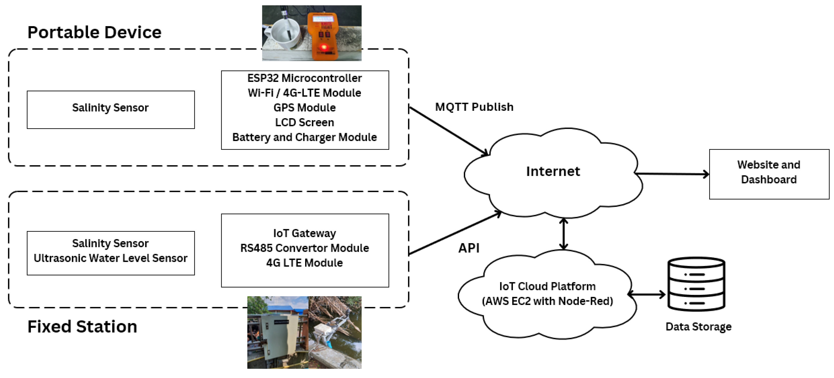
Figure 5 illustrates the architecture of a real-time salinity monitoring system developed using Internet of Things (IoT) technology. The system comprises two primary components: a portable salinity monitoring device and a fixed monitoring station. The portable device integrates a salinity sensor, an ESP32 microcontroller, Wi-Fi/4G LTE communication modules, a GPS module, an LCD display, and a rechargeable battery. It transmits data to the cloud via the MQTT protocol. The fixed station includes a salinity sensor and an ultrasonic water level sensor connected through an IoT gateway with an RS485 converter and a 4G LTE module, sending data via an API to the cloud platform. Data from both systems is stored in a centralized database. The results are processed and visualized on a custom-developed dashboard website. Together, this integrated real-time monitoring system of salinity levels in the field provides an early warning capability to support sustainable water resource management.
3.2. Sensor Technology and Calibration
The real-time salinity intrusion early warning system (EWS) in Bang Kachao relies on high-precision IoT-based sensors to continuously monitor water quality. These sensors are deployed in both fixed monitoring stations and portable measuring devices, ensuring comprehensive spatial coverage and data accuracy (
Figure 6). The system consists of eight fixed monitoring stations, each equipped with IoT-enabled sensors that measure key water quality parameters, including salinity (electrical conductivity), total dissolved solids (TDS), water temperature, and water level. These sensors transmit real-time data via 4G/5G networks and LoRaWAN communication protocols to a cloud-based data management system, allowing continuous monitoring, analysis, and visualization.
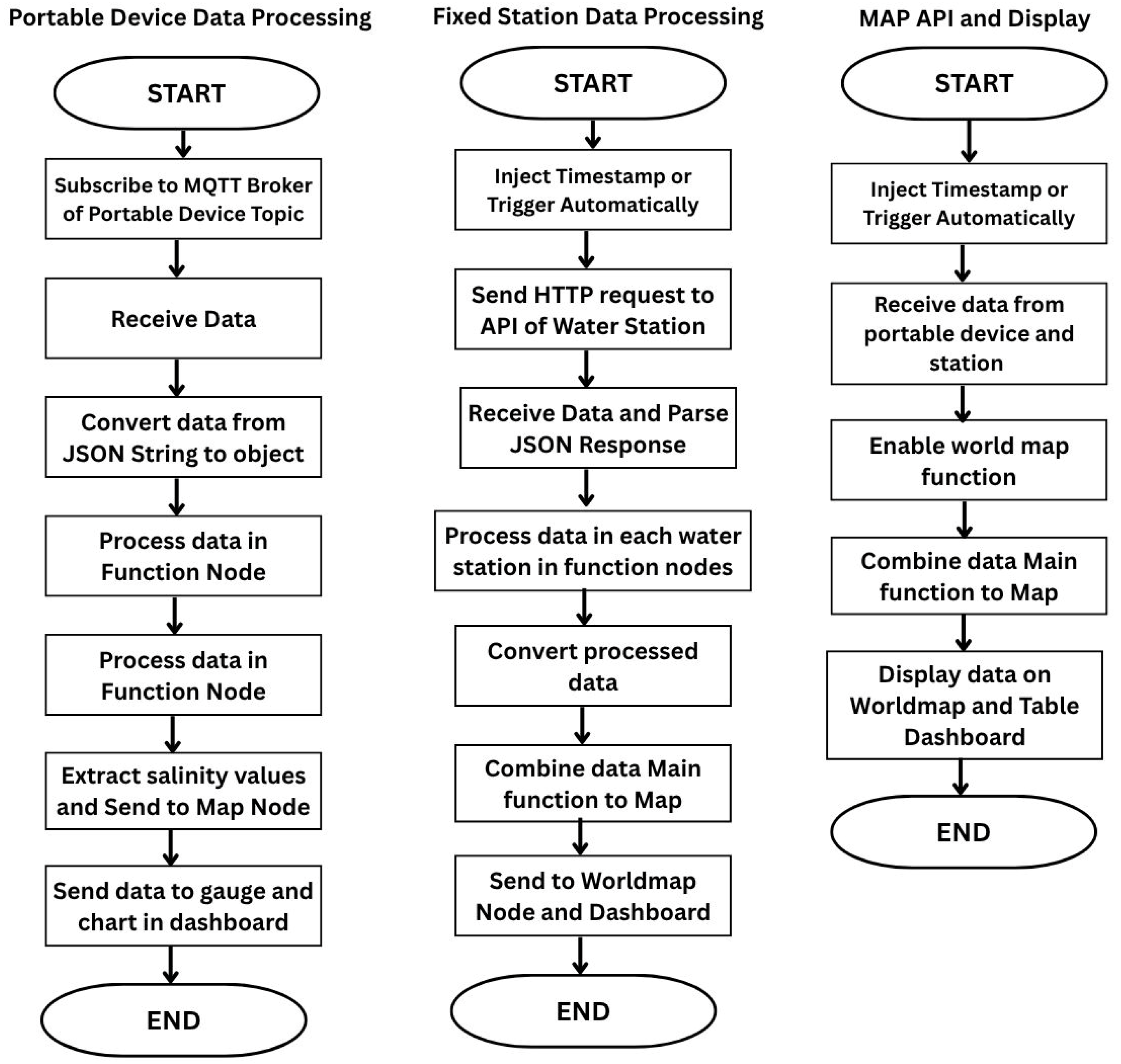
The entire data processing and automation workflow is managed using a Node-RED Flow (
Figure 7), which enables intuitive, real-time data handling and integration with alert systems and dashboards. In addition to these fixed stations, twenty portable measuring devices are distributed among local villagers and community representatives to enable on-demand water quality assessments in areas not covered by the fixed stations.
A key feature of the portable devices is their integrated GPS functionality, which allows for precise geolocation of measurement points. This ensures that water quality data collected by villagers is accurately mapped in relation to existing fixed monitoring stations, enabling better visualization of spatial variations in salinity levels. The integration of both fixed and portable measurement data into an interactive map enhances real-time tracking of water quality across Bang Kachao, improving decision-making for water resource management and ensuring localized salinity monitoring.
To maintain measurement reliability, all sensors undergo regular calibration following standardized protocols. Calibration procedures involve comparing sensor readings with laboratory-analyzed water samples, routine cross-validation between fixed station data and portable device measurements, and environmental durability testing to ensure sensor stability under varying temperature, humidity, and tidal conditions. The combined use of fixed monitoring stations and portable GPS-equipped devices significantly enhances the effectiveness of real-time salinity monitoring. This hybrid approach ensures early detection of salinity fluctuations, allowing for proactive responses and improved protection of freshwater resources in the area.
3.3. System Deployment and Community Engagement
To ensure effective coverage of salinity intrusion across Bang Kachao, eight fixed monitoring stations were strategically installed based on hydrological zoning, covering upstream to downstream flow, proximity to known salinity hotspots, and accessibility for maintenance. These stations were positioned across both inner and outer zones to capture variations in tidal intrusion and water inflows. In addition, 20 portable devices were distributed based on input from local stakeholders, allowing community members to conduct on-demand salinity measurements in critical areas not covered by the fixed network. This hybrid design balances comprehensive spatial monitoring with community engagement, enhancing real-time responsiveness and supporting long-term system sustainability.
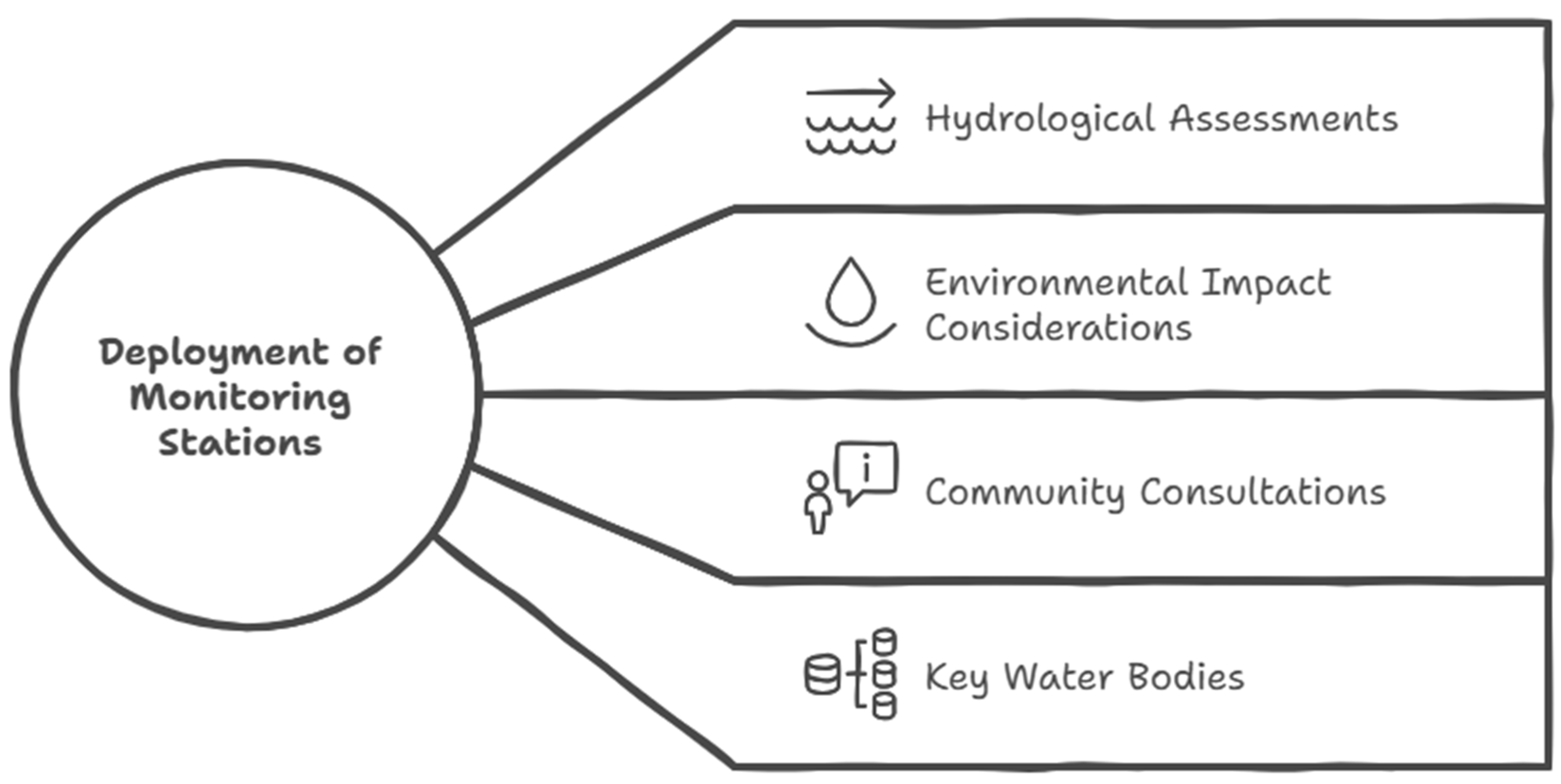
The deployment of fixed monitoring stations was guided by hydrological analysis, environmental impact considerations, and community consultations (
Figure 8). The stations were strategically placed in key water bodies, irrigation canals, and river tributaries that are most vulnerable to salinity intrusion. This ensures comprehensive spatial coverage while optimizing data collection in high-risk areas. For example, Station OT1 was strategically placed at the downstream section of Bang Kachao, where the Chao Phraya River meets a secondary irrigation canal, making it highly susceptible to tidal saltwater intrusion, especially in the dry season. Positioned near key agricultural water intake points, it enables early detection of salinity encroachment, helping farmers and local authorities manage irrigation effectively. Its proximity to a reliable electricity source ensures uninterrupted operation, while co-location with a Metropolitan Waterworks Authority (MWA) station allows for data cross-validation. By providing real-time monitoring, OT1 enhances proactive water management and early warning capabilities.
Community involvement was a fundamental part of the deployment process. Villagers and local government representatives participated in stakeholder meetings, training workshops, and pilot testing before the system was fully implemented. Training sessions covered topics such as sensor operation, data interpretation, and emergency response measures. This participatory approach not only enhanced local understanding of salinity intrusion but also increased the long-term sustainability and adoption of the system. This community involvement is displayed in
Figure 9.
3.4. Data Processing and Alert Mechanism
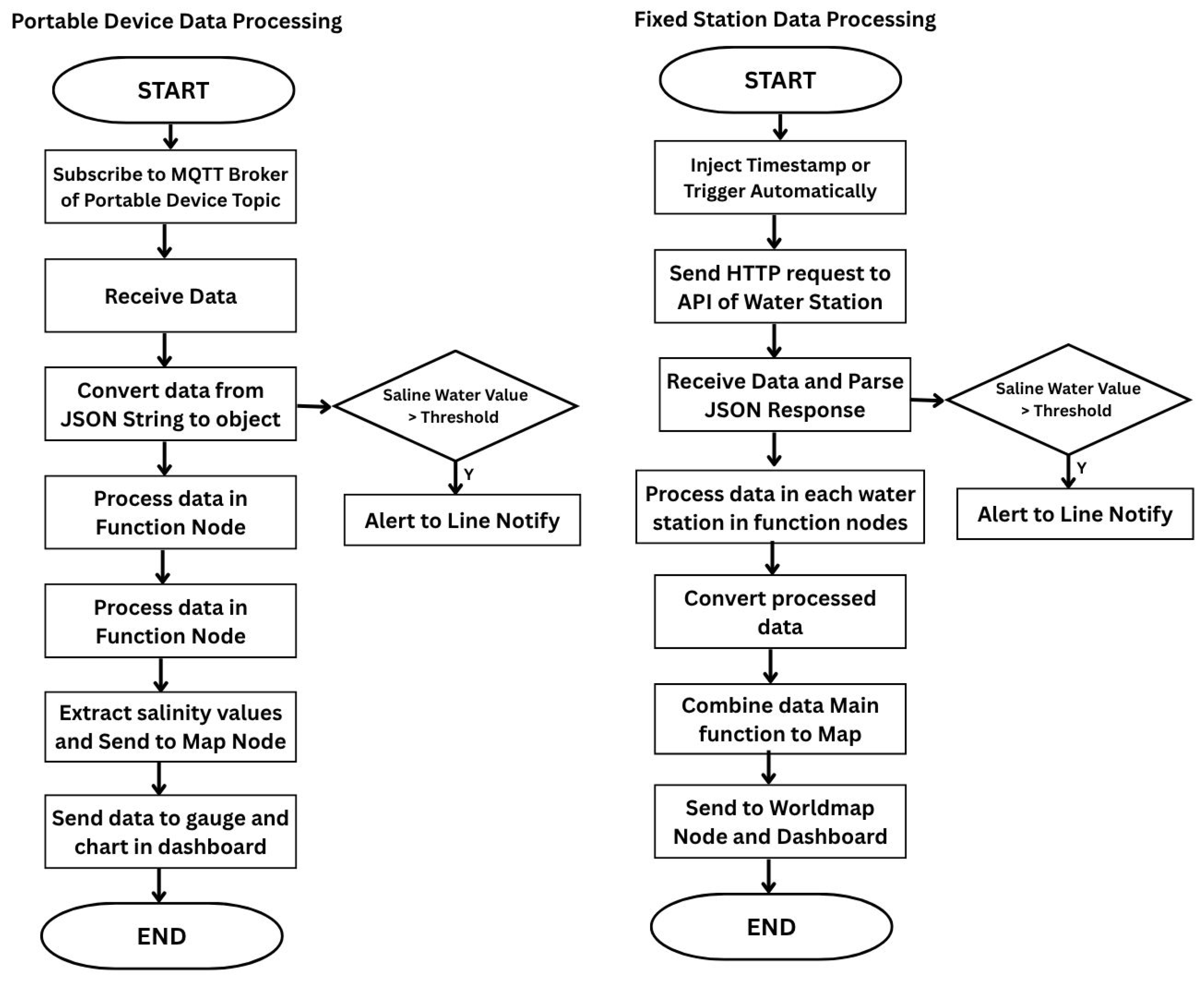
The system employs an automated data processing framework that continuously analyzes incoming sensor data. Raw data from fixed and portable monitoring devices is transmitted to a centralized cloud-based platform, where it undergoes real-time processing and anomaly detection.
The alert mechanism (
Figure 10) is designed to notify stakeholders of potential salinity risks as soon as predefined threshold levels are exceeded. Notifications are disseminated through mobile application alerts and website updates. This ensures that farmers, water managers, and local authorities receive timely warnings and can implement preventative measures, such as adjusting irrigation schedules or modifying water gate operations.
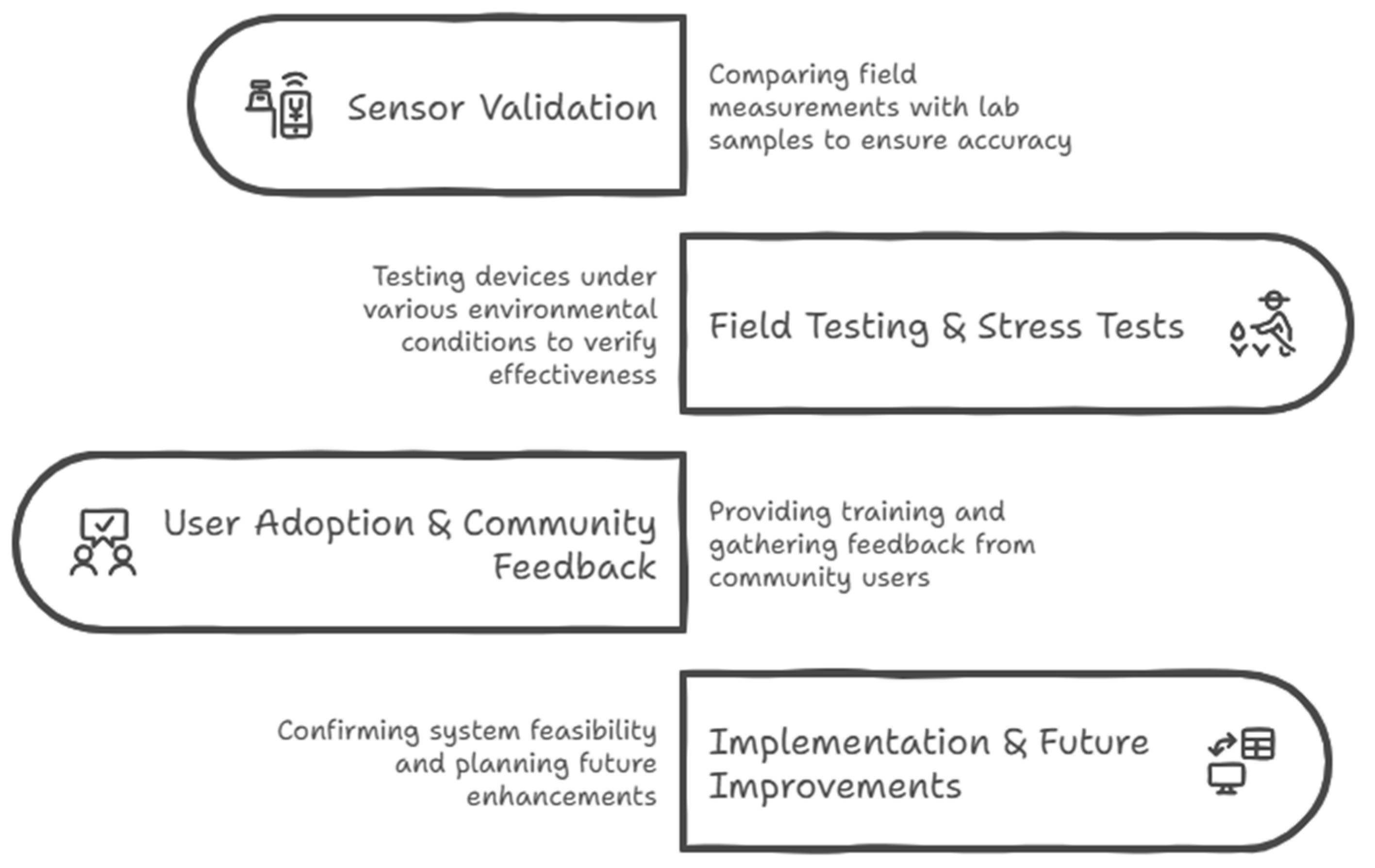
3.5. System Validation and Field Testing
Prior to the 7-month field-testing period, a calibration and validation phase was conducted to ensure the accuracy and reliability of salinity measurements from both the fixed monitoring stations and the portable devices, as well as to evaluate the consistency between the two systems. To verify measurement accuracy, 40 water samples were collected from multiple representative locations across Bang Kachao, covering a range of salinity conditions. At each site, simultaneous salinity readings were taken using the fixed sensors, portable devices, and a laboratory-grade benchtop conductivity meter. These field samples were subsequently analyzed in a certified laboratory using standardized methods to serve as the reference values.
To assess the correlation between fixed and portable measurements, a paired sampling campaign was also conducted. Portable salinity devices were used to collect data in proximity—within 10 to 20 m—of the fixed monitoring stations and within a ±2 min timeframe to ensure temporal alignment. Data from both sources were recorded and statistically analyzed using the Pearson correlation coefficient to evaluate the degree of agreement. This process was carried out across all eight fixed station locations, with the participation of trained community members and technical staff. The correlation analysis aimed to verify whether the portable devices could effectively reflect the salinity dynamics measured by the fixed stations. The validation protocol involved cross-checking salinity readings from fixed and portable devices against laboratory-grade reference values, under varying field conditions, to ensure measurement precision and consistency before full deployment.
Figure 11 illustrates the four-phase process used to evaluate, deploy, and improve the salinity monitoring system. During the 7-month field-testing phase, eight fixed monitoring stations continuously recorded salinity, water level, temperature, and TDS data, transmitting readings in real time to a cloud-based platform via LoRaWAN and 4G/5G networks. In parallel, trained community members used twenty portable devices to perform localized salinity measurements in areas not covered by fixed stations. Portable readings were GPS-tagged and uploaded through a mobile application for integration with the central system. Monthly sensor maintenance and calibration ensured data accuracy, while system logs tracked data transmission performance. Community feedback was gathered through surveys and training follow-ups to evaluate usability and alert effectiveness. This phase enabled performance monitoring under real-world conditions and informed refinements to system operation and stakeholder engagement.
4. Results of the Monitoring System
The real-time salinity intrusion early warning system (EWS) was deployed in Bang Kachao and operated continuously for 7 months to evaluate its effectiveness in detecting salinity fluctuations, issuing timely alerts, and engaging local stakeholders in proactive water resource management. The system integrates eight fixed monitoring stations, twenty portable salinity measurement devices, a web-based data platform, and a real-time notification system via the Line application. The following sections summarize the key findings from data collection, system performance, community engagement, and overall system usability.
4.1. Fixed Monitoring Stations and Regional Comparisons
The system consists of eight fixed monitoring stations, strategically placed to monitor salinity dynamics within and around Bang Kachao. These stations are categorized as follows:
Stations within Bang Kachao (“IN” group): IN01, IN02, and IN04.
Stations surrounding Bang Kachao (“OUT” group): OT01, OT02, OT03, OT04, and OT05.
The fixed monitoring stations continuously recorded high-resolution salinity data, enabling the detection of seasonal patterns, sudden salinity surges, and the influence of tidal activity. The system is configured to transmit and display salinity data at 10-min intervals, resulting in 144 measurements per day per fixed station. This high-frequency sampling supports near real-time monitoring and enhances the system’s capability to promptly detect fluctuations. These measurements were cross validated with data from the Metropolitan Waterworks Authority’s Real-Time Water Quality Monitoring System Project [
32], which operates 15 monitoring stations. The nearest of these are the Lad Pho and Tha Rua Stations.
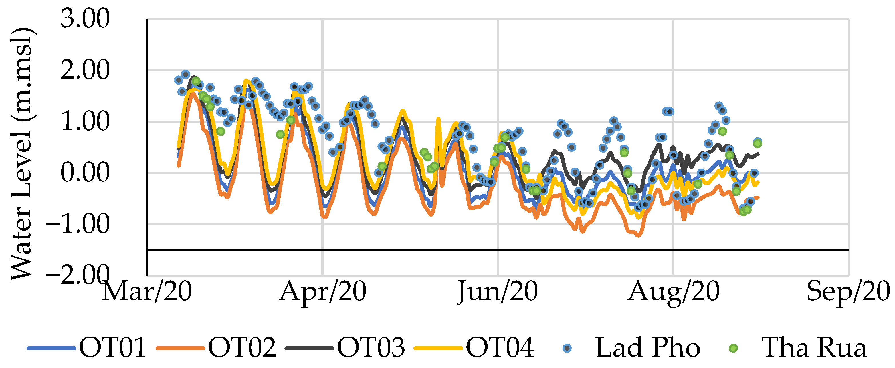
Figure 12 presents a comparison of water levels recorded at the outer fixed stations (OT 1–4) and the Lad Pho Station during the period from March 2020 to September 2020. The comparison between the water level measurements from the Bang Kachao EWS and MWA’s monitoring station confirmed that the system’s fixed stations provided consistent and accurate real-time data, reinforcing its reliability and effectiveness. Based on the correlation and mean difference analysis between the outer stations (OT01–OT04) and the two MWA reference stations (Lad Pho and Tha Rua) shown in
Table 2, the OT stations demonstrate strong alignment in both trend and magnitude. All OT stations show moderate to strong correlations with the MWA stations, indicating consistent temporal behavior in water level fluctuations. The mean differences between each OT station and Lad Pho range from 0.14 m (OT03) to 0.72 m (OT02), while differences with Tha Rua range from 0.13 m to 0.60 m. Among them, OT03 consistently exhibits the smallest differences, suggesting it is the most hydraulically aligned with both MWA stations. In contrast, the larger discrepancy observed at OT02 is likely due to its more distant location and positioning around a bend in the Bang Kachao area, which may influence local flow conditions. These findings support the conclusion that the OT stations—particularly OT03 and OT04—serve as reliable supplementary measurement points, effectively capturing the hydrodynamic behavior observed at the MWA stations. This consistency makes them suitable for water level validation and ongoing monitoring within the surrounding region.
4.2. Salinity Trends and Seasonal Variability
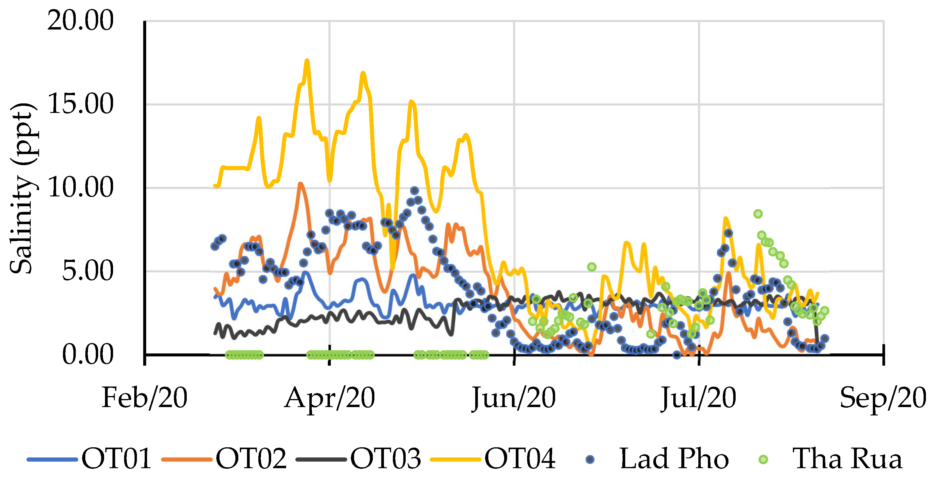
Figure 13 presents a comparison of salinity measurements from the Bang Kachao EWS and MWA’s monitoring stations. The salinity values from both systems show similar trends and fluctuations over the same measurement periods, reinforcing the system’s reliability. OT02 exhibits oscillation patterns closely matching those of Lad Pho, likely due to their close proximity. The mean salinity values from the OT stations also align well with those from the MWA stations. Specifically, OT02 (3.69) and OT04 (3.57) correspond closely with Lad Pho (3.82), while OT01 (3.09) and OT03 (2.72) are comparable to Tha Rua (3.21). Notably, OT03 is located near Tha Rua, further supporting this correlation, while OT04 lies directly to the south of the study area, capturing salinity dynamics influenced by tidal inflow from the Gulf of Thailand. These observations indicate a generally good level of agreement between the study’s measurements and official MWA data.
The correlation analysis between the weekly average salinity from the Bang Kachao EWS and the MWA monitoring stations demonstrates moderate degrees of alignment across different outer fixed stations. OT02 shows the highest correlation, with a strong positive relationship (r = 0.77) with Lad Pho, indicating that salinity fluctuations at OT02 closely mirror those recorded by the MWA station. OT01 exhibits a moderate correlation with Lad Pho (r = 0.57) and a weaker correlation with Tha Rua (r = 0.39), suggesting that it captures trends influenced by both upstream and downstream salinity dynamics. OT04 demonstrates a moderate correlation with Tha Rua (r = 0.45) but no notable correlation with Lad Pho, likely due to its more southern location and distinct hydrological influences. These findings confirm that the fixed monitoring stations generally reflect regional salinity patterns observed by official stations, thereby reinforcing the system’s reliability for early detection and water quality assessment.
The salinity values measured from the fixed stations were supported by those recorded from the portable devices, reinforcing the system’s accuracy and reliability. This alignment enhances data validation and spatial coverage, ensuring a more comprehensive monitoring approach. Portable devices serve as an on-demand verification tool, cross-checking fixed station readings and capturing localized variations in salinity that may not be detected by stationary sensors. The integration of both data sources into a centralized platform allows for real-time synchronization, minimizing discrepancies and improving data accuracy. Additionally, community involvement in operating portable devices increases data collection frequency and responsiveness, enabling faster detection of salinity fluctuations. The consistency between the two measurement methods strengthens confidence in system performance, demonstrating that portable devices effectively complement fixed stations.
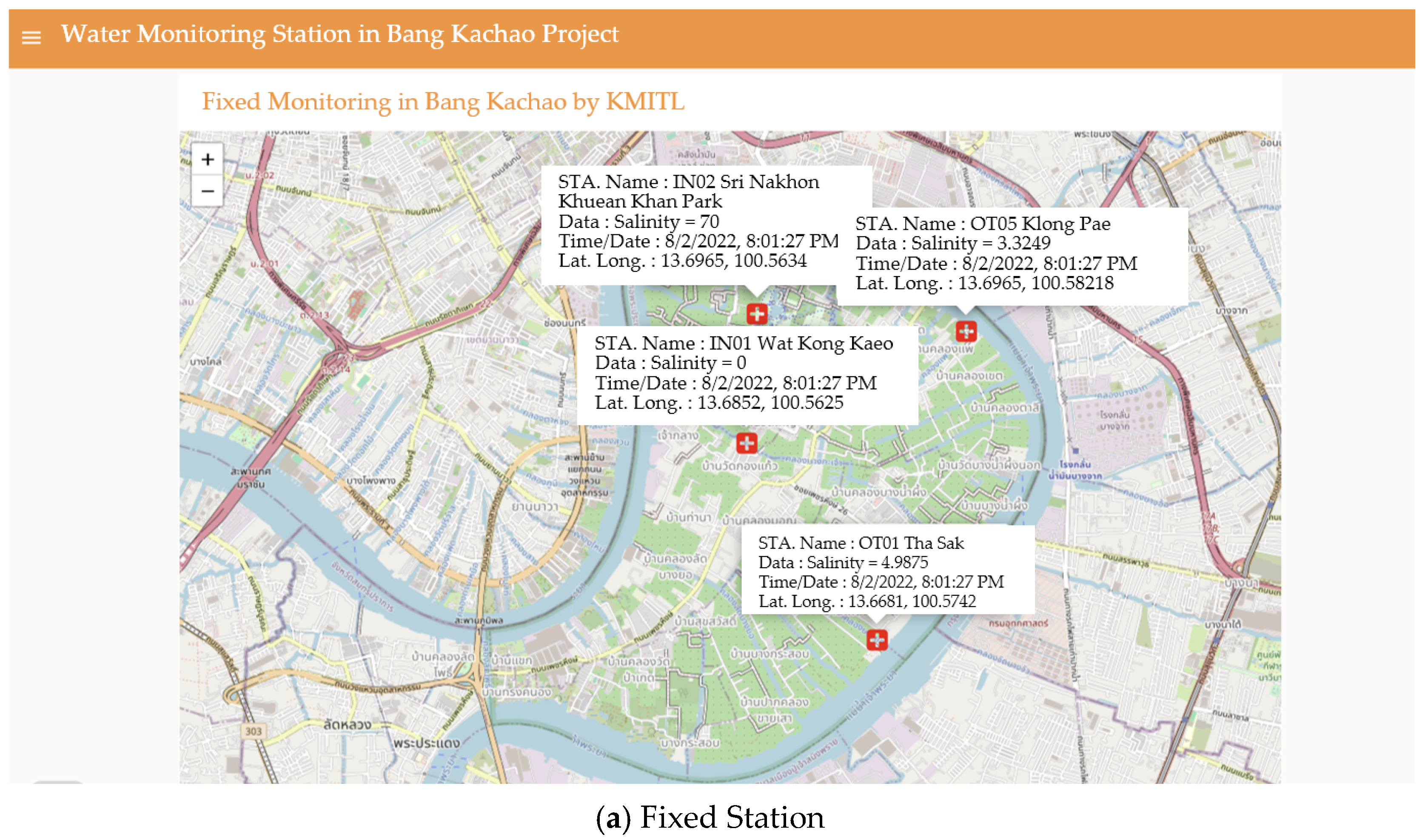
Figure 14 illustrates how data from both monitoring methods is displayed on the website, pinpointing the exact locations of measurements. The notification system provides essential details, including the station or device name, measurement location, date and time, and recorded salinity values, ensuring real-time accessibility and transparency for stakeholders.
4.3. Accuracy and Performance of the Monitoring System
To ensure salinity measurement accuracy and overall system reliability, sensor readings from both fixed monitoring stations and portable devices were validated using laboratory-analyzed water samples and cross-referenced with data from the Metropolitan Waterworks Authority (MWA)’s water quality monitoring stations. For the water level monitoring system, the performance of the fixed stations was compared to nearby MWA stations, as demonstrated in the previous section. The close alignment in observed trends and fluctuations between the two systems serves as an indicator of the accuracy and consistency of the monitoring network. The performance metrics of the system are summarized in
Table 3.
The results presented in
Table 3 demonstrate that the monitoring system performs with high accuracy and communication reliability. The fixed stations achieved a salinity measurement accuracy of 90.5%, while portable devices followed closely at 88.7%, confirming their effectiveness for both continuous and on-demand monitoring; these values were validated against laboratory-analyzed water samples. The 92.0% correlation between portable devices and fixed stations further supports the validity of portable measurements for cross-checking and localized assessments. The Data Transmission Success Rate of 97.0% for both fixed and portable units highlight the system’s robust communication design, ensuring consistent real-time data flow to the cloud platform. When compared with the Metropolitan Waterworks Authority (MWA)’s monitoring stations, the fixed stations showed a moderate level of alignment for salinity measurements, due to localized variability and environmental factors, but demonstrated high alignment in water level measurements, indicating strong consistency in tracking hydrological trends. The integration of fixed and portable monitoring enhanced spatial coverage, making the system a robust and scalable solution for proactive water management and early salinity warnings in Bang Kachao.
The evaluation confirmed that the real-time early warning system provides highly reliable and accurate salinity and water level measurements, ensuring effective monitoring, early detection of salinity intrusions, and seamless data accessibility via the web-based platform.
4.4. Effectiveness of Early Warning Alerts and Website Accessibility
The early warning system has been fully optimized to provide timely and user-friendly alerts through both a web-based platform and the Line application, enabling real-time monitoring and immediate response to salinity fluctuations (
Figure 15). The website functions as the central data hub, offering live salinity readings from all monitoring stations, historical trend analysis, and alert notifications in an accessible and intuitive format. To enhance accessibility and responsiveness at the community level, the Line application was integrated as a complementary alert mechanism. Based on community feedback, the system was configured to send salinity alerts via the Line application every 10 min if measurements exceed the predefined threshold of 2 parts per thousand (ppt). This update frequency balances real-time responsiveness with device energy efficiency, ensuring that stakeholders receive actionable warnings only when intervention is necessary. This threshold was selected in consultation with local farmers and water managers to align with crop tolerance levels and irrigation needs. The refinements have been well-received by community members, leading to improved decision-making for agricultural water use, enhanced preparedness during critical salinity events, and a significant reduction in false or excessive notifications. Overall, the alert system now balances technical precision with practical usability, supporting both environmental monitoring and local resilience.
4.5. Community Participation and System Usability
Community involvement has been a key factor in the success of the Bang Kachao EWS, ensuring local adoption, sustainability, and effective response to salinity risks. A total of 36 villagers, representing all 6 subdistricts of Bang Kachao, participated in a series of training sessions designed to provide hands-on experience in system operation and data interpretation.
During the training, villagers learned to
Monitor salinity levels via the website and Line application, gaining the ability to track trends, analyze data, and respond to alerts.
Operate and maintain the 20 portable salinity measurement devices, ensuring that they could perform independent field measurements and cross-validate data with the fixed stations.
The training sessions were highly successful, with 85% of participants reporting confidence in using the monitoring tools and over 70% actively engaging in salinity monitoring at least once per month. Villagers also shared their observations through the web-based platform, contributing to an improved community-driven monitoring network.
4.6. Comparison with Other River Basin Applications
While the hybrid real-time salinity intrusion monitoring system implemented in Bang Kachao shows strong potential for localized adaptation and early warning, several technical and practical limitations remain. These include occasional sensor noise, the need for periodic calibration to maintain accuracy, and dependence on stable network connectivity for data transmission and alert delivery. Furthermore, during periods of high humidity or field interference, measurement drift may reduce short-term data reliability without auto-calibration mechanisms.
Despite these challenges, the system design and participatory approach have high potential for replication in other deltaic or estuarine environments facing similar salinity intrusion risks. Notably, several regions in Asia and beyond have begun adopting comparable technologies.
Table 4 presents a comparative overview of key salinity monitoring systems from three major basins: the Mekong Delta in Vietnam, the Ganges–Brahmaputra Delta in Bangladesh, and coastal regions in China. The comparison highlights key similarities and distinctions in system architecture, community involvement, and technological implementation.
This comparison shows that the Bang Kachao system is unique in its hybrid model combining formal and community-collected data, and in its use of accessible communication platforms (e.g., Line) to ensure rapid, localized alerts. Unlike more centralized or satellite-driven models, this system emphasizes bottom-up engagement, making it suitable for data-scarce regions or secondary urban–rural areas that require both flexibility and real-time responsiveness.
Future implementations in other regions, such as the Mekong Delta or Ganges–Brahmaputra Delta, could adapt this model by tailoring sensor density, data transmission methods, and community training programs to local needs, terrain, and governance structures. Addressing the sensor limitations through multi-parameter sensing, automated calibration, and mesh-based network redundancy could further strengthen the system’s robustness and scalability.
5. Conclusions and Future Expansion
The hybrid monitoring approach, integrating both fixed stations and portable devices, proved to be highly effective in capturing both regional and localized salinity trends. This study introduces a novel, community-integrated hybrid real-time salinity monitoring system that combines continuous fixed-station data with on-demand, geolocated measurements from portable devices—an approach not yet implemented in Thailand and rarely documented in comparable estuarine environments globally. The combination of IoT-based real-time monitoring, community involvement, and web-based data accessibility has resulted in improved salinity monitoring capabilities, enabling timely interventions; increased stakeholder participation, fostering long-term system sustainability; scalability of the model with potential for expansion to other coastal and estuarine regions facing salinity intrusion challenges; enhanced accessibility through a user-friendly website providing real-time data, alerts, and historical trends; and cross-validation with official monitoring stations, ensuring consistency and accuracy in regional water quality assessments.
This study presents a community-driven, real-time early warning system for salinity intrusion that integrates fixed monitoring stations, portable devices, and cloud-based analytics. The system’s sustainability is ensured through local involvement, government integration, and reliable data transmission. By combining real-time monitoring, community engagement, and accessible data platforms, this approach enables timely detection of salinity fluctuations and supports proactive water management strategies in Bang Kachao. The system has demonstrated high accuracy and effectiveness in monitoring salinity levels, with field testing confirming over 90% accuracy in detecting salinity intrusions before reaching critical thresholds. Moreover, community participation in the system’s implementation and maintenance enhances its long-term sustainability and usability.
The findings of this study underscore the importance of integrating local knowledge, technological advancements, and participatory monitoring approaches to achieve equitable and effective water resource management. The hybrid model addresses challenges related to spatial variability in salinity intrusion and offers a scalable, adaptable solution for other regions experiencing similar water quality threats. Active involvement of local stakeholders in data collection, decision-making, and system upkeep fosters a sense of ownership, further ensuring the long-term viability of the monitoring network.
Future work will focus on enhancing sensor precision by developing multi-parameter devices capable of measuring salinity, temperature, electrical conductivity, and turbidity simultaneously. Future work will also explore the correlation between salinity, total dissolved solids (TDS), water temperature, and water level to improve understanding of salinity intrusion dynamics. This will allow for cross-parameter validation and early detection of sensor anomalies. Additional improvements include implementing automated calibration (auto-calibration) algorithms to reduce manual maintenance and minimize drift under field conditions. Community feedback has also emphasized the importance of improved accuracy, particularly during tidal salinity surges. Furthermore, research will aim to improve the alert mechanism and expand the system to cover additional vulnerable areas. Community-based training programs will be strengthened to ensure that local users can independently operate and maintain the system, interpret data, and respond effectively. Data analytics and machine learning tools will be incorporated to improve pattern recognition, trend forecasting, and early warning capabilities. Lastly, a comprehensive evaluation of the Social Impact Index (SOI) will be conducted to compare the performance and resilience of fixed-only versus hybrid monitoring models. This will provide deeper insights into the value of community engagement and flexible deployment strategies in real-time salinity monitoring and water resource management.
Beyond Bang Kachao, this real-time early warning system can be expanded and adapted to other coastal and estuarine regions facing salinity intrusion, climate-driven hydrological changes, and freshwater resource scarcity. The modular nature of the system allows customization for various environmental contexts, ensuring wide applicability. Scaling up the system will require collaboration with local policymakers, academic institutions, and international research organizations to improve governance, support long-term operations, and foster multi-stakeholder participation. By leveraging real-time data collection, cloud-based accessibility, and active community participation, this study contributes to a more sustainable and resilient water management framework that supports freshwater security for agricultural, domestic, and ecological needs in Bang Kachao and beyond.


