Article

Ice Avalanche-Triggered Glacier Lake Outburst Flood: Hazard Assessment at Jiongpuco, Southeastern Tibet

1
Northwest Engineering Corporation Limited, Power Construction Corporation, Xi’an 710065, China
2
College of Geoscience and Engineering, North China University of Water Resources and Electric Power, Zhengzhou 450045, China
3
State Key Laboratory of Geohazard Prevention and Geoenvironment Protection, Chengdu University of Technology, Chengdu 610059, China
4
Sichuan Highway Planning, Survey, Design and Research Institute Ltd., Chengdu 610041, China
*
Author to whom correspondence should be addressed.
Water 2025, 17(14), 2102; https://doi.org/10.3390/w17142102
Submission received: 2 June 2025 / Revised: 5 July 2025 / Accepted: 9 July 2025 / Published: 15 July 2025
(This article belongs to the Special Issue Water-Related Landslide Hazard Process and Its Triggering Events)

Abstract

With ongoing global warming, glacier lake outburst floods (GLOFs) and associated debris flows pose increasing threats to downstream communities and infrastructure. Glacial lakes differ in their triggering factors and breach mechanisms, necessitating event-specific analysis. This study investigates the GLOF risk of Jiongpuco Lake, located in the southeastern part of the Tibetan Plateau, using an integrated approach combining remote sensing, field surveys, and numerical modeling. Results show that the lake has expanded significantly—from 2.08 km2 in 1990 to 5.43 km2 in 2021—with the most rapid increase observed between 2015 and 2016. InSAR data and optical imagery indicate that surrounding moraine deposits remain generally stable. However, ice avalanches from the glacier terminus are identified as the primary trigger for lake outburst via wave-induced overtopping. Mechanical and geomorphological analyses suggest that the moraine dam is resistant to downcutting erosion, reinforcing overtopping as the dominant failure mode. To assess potential impacts, three numerical simulation scenarios were conducted based on different avalanche volumes. Under the extreme scenario involving a 5-million m3 ice avalanche, the modeled peak discharge at the dam site reaches approximately 19,000 m3/s. Despite the high flood magnitude, the broad and gently sloped downstream terrain facilitates rapid attenuation of flood peaks, resulting in limited impact on downstream settlements. These findings offer critical insights for GLOF hazard assessment, disaster preparedness, and risk mitigation under a changing climate.

1. Introduction

As the “Third Pole” of the Earth and Asia’s primary water tower, the Tibetan Plateau (TP) contains the greatest concentration of glaciers outside the polar regions [1,2,3,4,5]. These glaciers are essential in sustaining the hydrological regimes of many major rivers across Asia [6,7]. However, the acceleration of global warming has led to widespread glacial retreat, shifting mass balance conditions toward a persistent net ice loss [8,9,10]. This retreat has substantially increased snow and glacial meltwater runoff, thereby fostering conditions conducive to the formation and continuous expansion of glacial lakes [11,12,13]. As glaciers retreat, newly exposed terrain accumulates meltwater, gradually forming and enlarging glacial lakes within topographic depressions and low-lying areas [14]. Considerable research efforts have been made to clarify the spatiotemporal evolution of glacial lakes on the TP [15,16], relying on comprehensive inventories that span from large-scale surveys—encompassing the entire TP or the High Mountain Asia region—to more detailed regional studies targeting the southeastern Tibetan Plateau (SETP), the Himalayas, the Tianshan, and the Karakoram ranges [17,18,19]. These studies consistently reveal an ongoing expansion in both the number and size of glacial lakes over recent decades, a phenomenon closely linked to continuous glacier retreat [14,18,19], with particularly dramatic transformations noted in the SETP region [20]. It is also well-documented that since 1990, more than 3000 new glacial lakes have formed on the TP, and their total area has grown by over 200 km2 [14]. Nevertheless, spatial heterogeneity in lake development persists, as the distribution patterns and growth rates of glacial lakes vary significantly across regions [21,22]. This emphasizes the urgent need for detailed field-based assessments in specific subregions, especially those with complex topography and high densities of small glacial lakes [23].
The continued expansion of glacial lakes significantly heightens the risk of glacial lake outburst floods, which represent one of the most severe natural hazards on the Tibetan Plateau (TP) [24,25,26]. GLOFs are characterized by their sudden onset, immense destructive force, and inherent unpredictability, posing substantial threats to downstream populations, ecosystems, and infrastructure [24,25,26]. Historically, many GLOF events have manifested as high-energy, sediment-laden flows or debris-laden mudslides capable of traveling tens of kilometers, thereby amplifying their catastrophic impact [27]. The Eastern and Central Himalayan regions are particularly vulnerable, with a documented history of recurrent GLOFs that have caused considerable human casualties and extensive economic losses [28,29]. Since 1900, approximately 189 GLOF incidents have been recorded across the Himalayan region, leading to over 6600 fatalities and widespread damage to critical infrastructure. These events have severely impeded regional economic development and societal resilience [30]. To better understand and mitigate GLOF risks, previous studies have applied various methodological frameworks at macro scales, including satellite-based analyses, remote sensing technologies, and field investigations. For instance, Aggarwal et al. (2017) [31] assessed the GLOF susceptibility of 472 glacial lakes in Sikkim (Eastern Himalaya) using the Analytic Hierarchy Process (AHP), while Khadka et al. (2021) [32] employed a multi-criteria decision analysis to evaluate GLOF risk in the Mahalangur Himalaya region. Despite these efforts, comprehensive risk assessments that concurrently address both hazard probability and socio-environmental vulnerability remain scarce and underdeveloped [33]. Modeling and simulating potential GLOF-induced flood events are critical, given the potential for widespread inundation and long-range downstream impacts. Such simulations can inform disaster preparedness by identifying vulnerable areas and estimating flood magnitudes [34]. In this context, multiple studies have conducted numerical simulations in Nepal and along the transboundary regions between China and Nepal, utilizing diverse hydrodynamic models to evaluate flood extents and inform transboundary hazard mitigation strategies [35,36,37,38]. These areas are especially notable for past high-impact events such as the 1981 Cirenmaco GLOF, which claimed 200 lives and destroyed key infrastructure including the China–Nepal Highway and the Friendship Bridge [39,40]. Similarly, the 2016 Gongbatongshaco GLOF in Tibet caused widespread destruction to the China–Nepal Highway and the upper Bhotekoshi hydropower station, with economic damages estimated at approximately USD 70 million [41,42].
The SETP is characterized by a substantial number of marine glaciers that are highly sensitive to climatic variations, making glacial lake dynamics in this region particularly significant with respect to potential GLOFs [43,44,45,46,47]. Furthermore, the SETP region is host to critical infrastructure projects, including major railway lines and hydropower stations, which heighten the potential impacts of GLOFs.
The southeastern Tibetan Plateau (SETP) is distinguished by a dense distribution of glaciers, which are highly responsive to climatic fluctuations and contribute significantly to regional glacial lake dynamics [43,44,45,46,47]. These dynamics are especially critical in the context of potential GLOFs, as the region exhibits heightened sensitivity to environmental perturbations. Additionally, the presence of strategically important infrastructure—such as major hydropower installations and railway networks—further elevates the stakes associated with GLOF hazards in the SETP. Among the glacial lakes in this region, Jiongpuco Lake stands out as the largest moraine-dammed lake on the southeastern margin of the Tibetan Plateau and has garnered increasing attention due to its high outburst potential.
In this study, we conducted a multi-phase assessment to examine both the physical characteristics and failure risk of the lake. First, remote sensing imagery was used to analyze temporal variations in lake area over recent decades. Next, we applied Synthetic Aperture Radar (SAR) data along with Interferometric SAR (InSAR) techniques to identify dominant triggering mechanisms for potential GLOF events. Particular focus was placed on assessing the likelihood of ice-avalanche-induced GLOF. Finally, we simulated the full process chain—from ice avalanche entry to wave generation and downstream flood propagation—using two well-established numerical models: R.avaflow and HEC-RAS. These integrated analyses, following a sequential process-based framework, provide critical insights into the cascade of processes that could lead to a GLOF event at Jiongpuco Lake and serve as a foundation for improved risk assessment and disaster mitigation strategies under evolving climatic scenarios.

2. Study Area, Data, and Methods
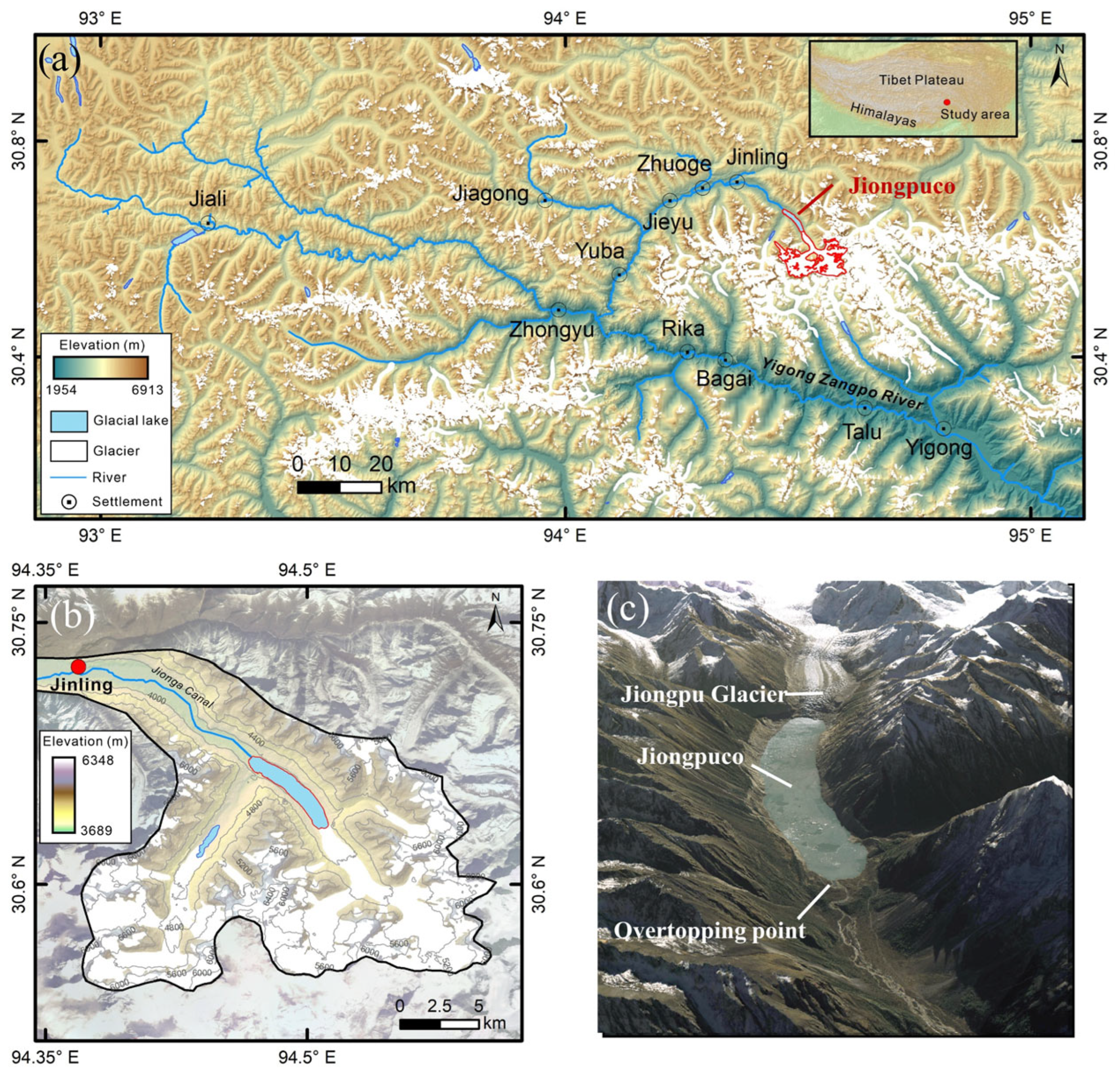
2.1. Study Area

Jiongpuco [94.50° E, 30.65° N] is situated in the southeastern part of the Tibetan Plateau (Figure 1a), within a geodynamically active zone marked by intense tectonic convergence between the Indian and Eurasian plates [48]. This region is characterized by high relief, steep glacial valleys, and a complex geological framework, which—when coupled with rising temperatures and increasing monsoonal precipitation—creates a high-risk environment for glacier-related geohazards, including GLOFs and debris flows [5].
Hydrologically, Jiongpuco lies at the northeastern headwaters of the Yigong Zangpo River, a tributary of the Yarlung Tsangpo River. The lake was formed primarily through continuous glacier retreat and maintains a proximal connection with its parent glacier (Figure 1b). The natural dam impounding the lake is primarily composed of unconsolidated lateral and terminal moraine material, which is mechanically weak and potentially unstable under dynamic loading. Notably, a smaller proglacial lake located upstream and to the southwest of Jiongpuco shows geomorphic evidence of previous outburst events, suggesting a historical precedent for cascading lake failures in the watershed [49]. Downstream, approximately 29 km from Jiongpuco, lies Jinling Township—a densely inhabited valley settlement with more than 480 households and a resident population exceeding 2000 [49]. The topographic configuration between the lake and the township is characterized by steep channel gradients and narrow valleys, conditions which are conducive to high-magnitude, rapid-flow flood propagation.
According to multi-temporal satellite observations, Jiongpuco has undergone significant areal expansion in recent decades. From 2014 to 2019, it was identified as the fastest-growing glacial lake in High Mountain Asia [50,51], with its area nearly doubling over this short period. The accelerating retreat of the feeding glacier and continued thermal destabilization of surrounding slopes have elevated concerns regarding its outburst potential. A sudden release of water from Jiongpuco could severely threaten not only Jinling Township but also downstream infrastructure, including roads, hydropower installations, and bridges, posing substantial risks to regional socioeconomic stability and disaster preparedness.

2.2. Glacial Lake Mapping

To assess glacial lake area changes at Jiongpuco, we extracted lake boundaries using long-term Landsat imagery. Landsat-4 and -5 data (1984–2011) and Landsat-7, -8, and -9 imagery (1999–present) were used, providing 30 m multispectral and 15 m panchromatic resolutions. Image preprocessing was performed on the Google Earth Engine platform. To minimize cloud interference and snow cover, images from November to December with less than 10% cloud cover were selected. Lake outlines were manually interpreted using false-color composites and topographic context. As the bottom geometry was not available in the DEM data, lake volume was estimated using an established empirical area–volume relationship (R2 = 0.99) [52]
V = 42.95A1.408,
where V represents the lake volume (Mm3) and A represents the lake area (km2).

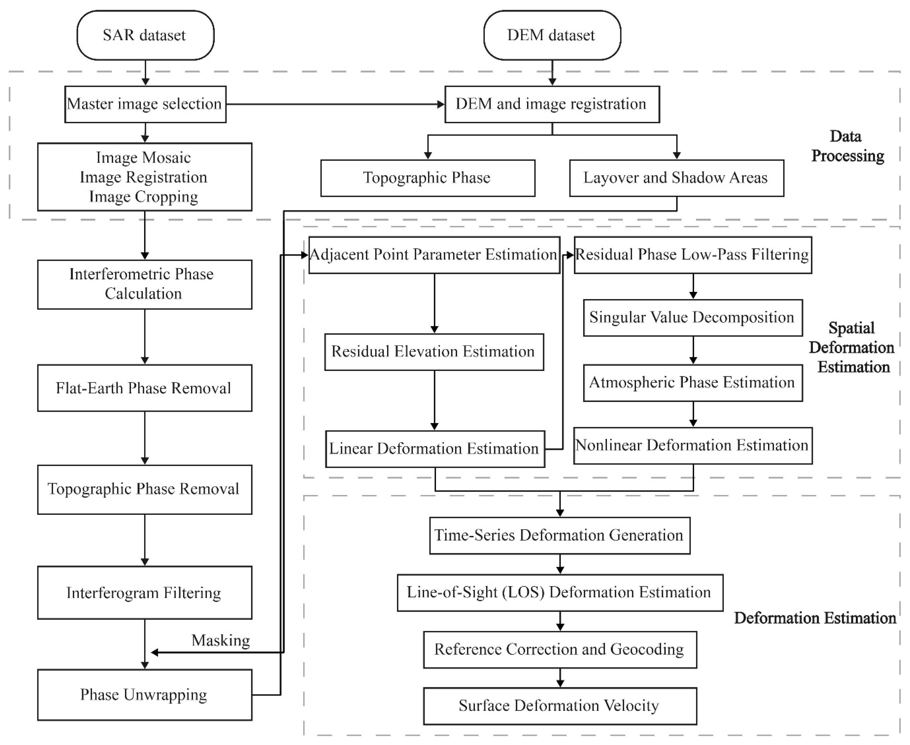
2.3. Insar Data and Methods

Sentinel-1A, the first C-band radar satellite of the European Space Agency’s Copernicus Program, was launched in 2014 for environmental monitoring applications. It acquires SAR data in Interferometric Wide (IW) swath mode, offering a spatial resolution of 5 m × 20 m and a 12-day revisit cycle. The dataset features wide coverage, short revisit intervals, and dual-polarization capabilities. We collected Sentinel-1 SAR images for the study area, with ascending track images spanning from June 2021 to December 2024 (83 scenes) and descending track images covering the period from May 2021 to December 2024 (103 scenes). The specific parameters of the SAR images are listed in Table 1.
The Small Baseline Subset InSAR (SBAS-InSAR) technique was employed to retrieve surface deformation rates and time series by generating interferograms with short temporal and spatial baselines. As outlined in Figure 2, raw SAR images underwent preprocessing, including precise orbit correction, co-registration to a reference (master) image, and cropping to the region of interest. Interferometric processing was conducted using predefined baseline thresholds, and topographic phase components were removed using external DEM data. The resulting interferograms were filtered and unwrapped, followed by quality screening to exclude those affected by severe decorrelation or unwrapping errors. Atmospheric artifacts were mitigated through spatiotemporal filtering, and deformation velocities were estimated via singular value decomposition. The final time-series deformation products were geocoded to obtain spatially referenced deformation patterns across the study area.
To further mitigate atmospheric noise, external atmospheric delay data from the Generic Atmospheric Correction Online Service (GACOS) are incorporated for correction of interferometric phase signals. The temporal and spatial baseline thresholds are set to 120 days and 120 m, respectively. To minimize decorrelation associated with temporal baselines, a Sentinel-1 ascending-track SAR image in January 2023 is selected as the common master, resulting in 541 interferometric pairs. Among these, 271 pairs exhibiting significant atmospheric disturbance and decorrelation are excluded, yielding 270 high-quality pairs for time-series deformation analysis. For the descending-track dataset, a SAR image from the same month (January 2023) is designated as the common master, generating 644 initial interferometric pairs. After discarding 370 pairs severely affected by decorrelation and atmospheric artifacts, 274 pairs are retained for subsequent time-series analysis.

2.4. GLOF Simulation with R.avaflow and HEC-RAS

To comprehensively simulate both the initiation and downstream propagation of a GLOF, this study adopted a sequential modeling framework integrating R.avaflow (for the ice avalanche, lake area, and up to 2 km downstream) and HEC-RAS (for the 2–55 km downstream). This hybrid approach captures the dynamic initiation mechanisms near the glacial lake and the subsequent hydraulic responses along downstream river corridors. The multiphase mass flow model R.avaflow (V 4.0, Martin Mergili, Graz, Austria) was first applied to simulate proximal GLOF processes triggered by ice avalanches [53]. The model accounts for the interactions between solid (e.g., moraine or landslide debris) and liquid (lake water) phases, incorporating key processes such as erosion, entrainment, and deposition over complex terrain. A 30-m resolution SRTM Digital Elevation Model (DEM) was used to define basin morphology, extract cross-sectional profiles, and construct the computational domain. Based on observed crevasse distributions at the glacier terminus and empirical estimates of avalanche volumes across the Tibetan Plateau, three avalanche scenarios were designed to assess their potential to initiate GLOFs: 0.5 Mm3 (small), 2.5 Mm3 (medium), and 5.0 Mm3 (large). For each scenario, the impact of the ice avalanche into the lake was modeled as the initiating trigger in R.avaflow to simulate wave generation, moraine overtopping, and initial flood propagation (e.g., Sattar et al., 2025 [54]).
Following this, the HEC-RAS (V6.6, Hydrologic Engineering Center, Davis, CA, USA)hydraulic modeling system was employed to route the flood wave through downstream valleys [54]. The outflow hydrograph from R.avaflow was used as the upstream boundary condition at the moraine dam location. River channel and floodplain geometries were derived from SRTM DEM data and processed into a two-dimensional computational mesh with a uniform 10-m grid, ensuring sufficient spatial resolution to capture flow dynamics. A Manning’s roughness coefficient of 0.03 was applied across both the main channel and overbank areas, representing typical conditions for alluvial riverbeds with minimal vegetation. A baseline flow of approximately 200 m3/s was assigned to represent the natural discharge of the river under non-flood conditions [49]. To assess hydrodynamic responses, 24 cross-sections were placed along the channel to monitor variations in water depth, flow velocity, and discharge.

3. Results

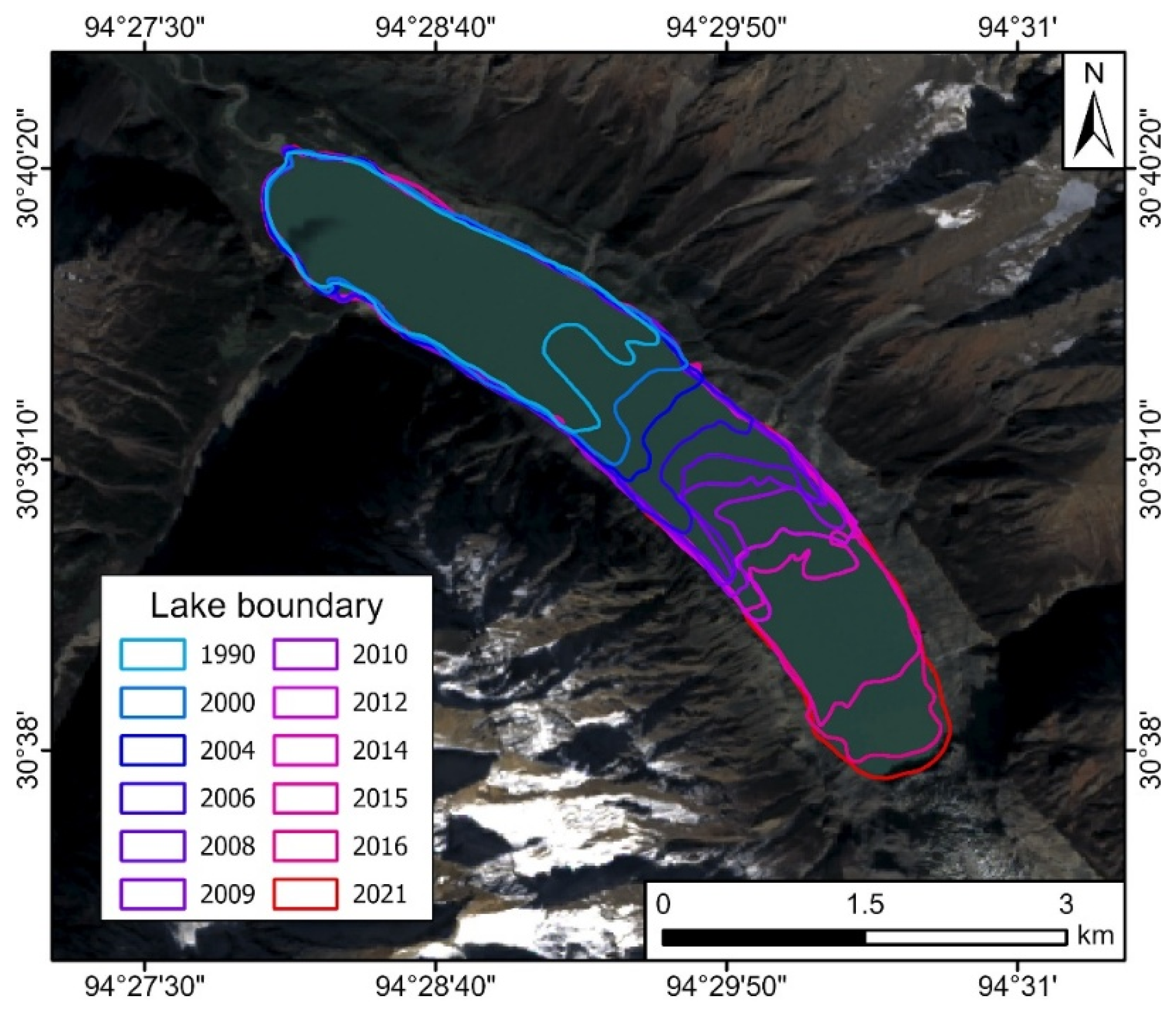
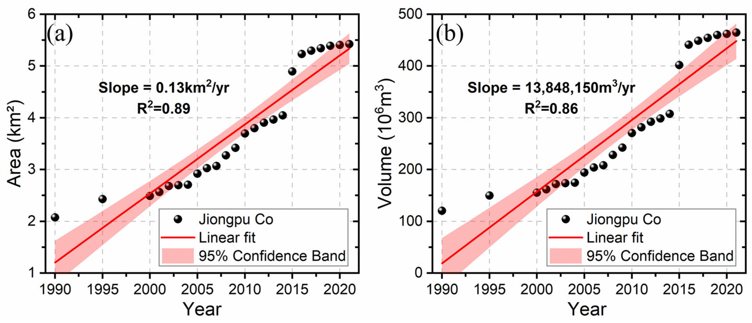
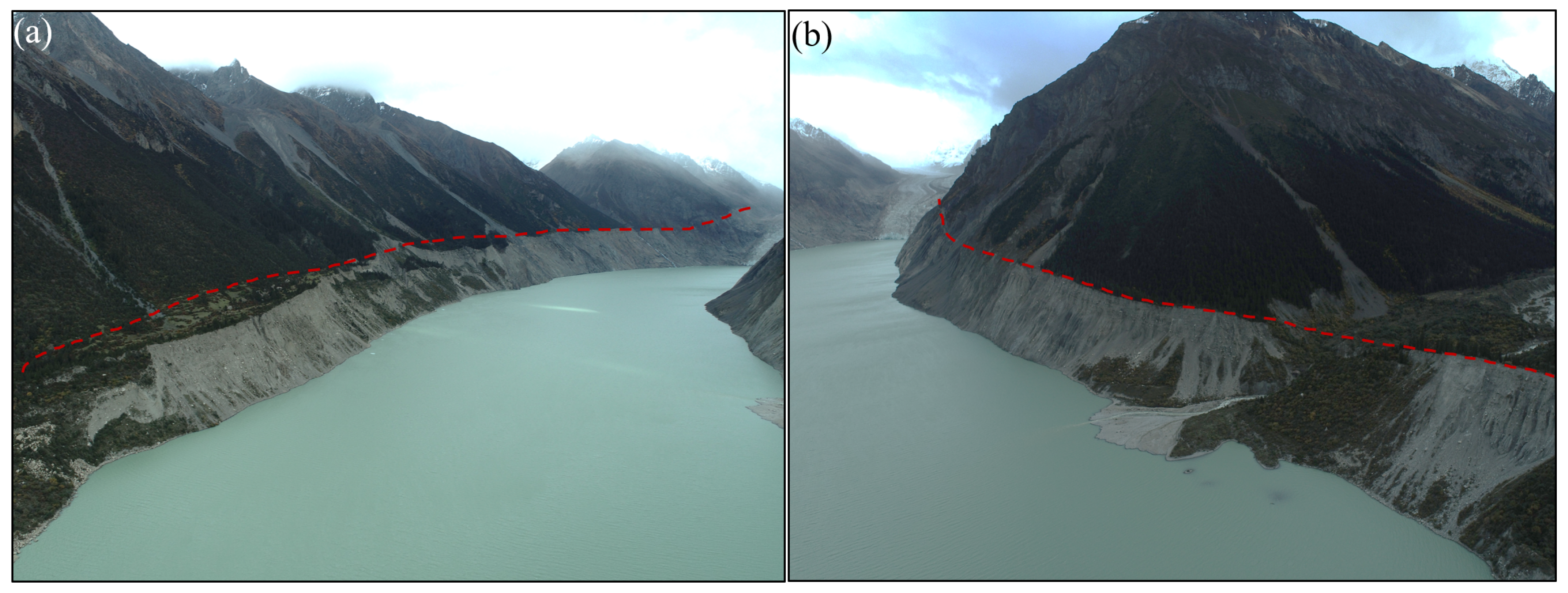
3.1. Jiongpuco Expansion

Figure 3 shows the glacial lake boundary of Jiongpuco from 1990 to 2021. Overall, this glacial lake exhibits significant and continuous expansion. The area of the glacial lake is 2.08 km2 in 1990, and the area of the glacial lake is 5.43 km2 in 2021. The total area has increased by 3.35 km2. The glacial lake expanded most notably in 2015 and 2016, with increases of 0.85 km2 and 0.34 km2, respectively. This may be associated with the increase in extreme rainfall and temperature rise in 2015 and 2016.
Figure 4a illustrates the temporal evolution of the Jiongpuco glacial lake area from 1990 to 2021. Over the entire observation period, the lake exhibits a consistent upward trend, with an average areal expansion rate of approximately 0.13 km2 per year (R2 = 0.89), indicating a strong linear relationship between time and surface area growth. This steady expansion reflects the ongoing retreat of the feeding glacier and aligns with broader regional trends observed across the SETP. In addition, based on the empirical area–volume scaling relationship, the annual volumetric estimates of the lake were derived and presented in Figure 4b. The results show that the glacial lake volume increased at an average rate of approximately 13.8 Mm3 per year (R2 = 0.86), which corresponds closely with the observed area increase. The high coefficient of determination further validates the consistency between surface area growth and volumetric expansion over the study period.
When integrating this analysis with the spatial distribution map of lake boundaries from 1990 to 2021, it is evident that the expansion predominantly follows the direction of glacier tongue retreat. This spatial pattern supports the inference that meltwater accumulation in newly exposed glacial depressions is the primary driver of lake enlargement. The increasing area and volume reinforce the conclusion that Jiongpuco is undergoing rapid hydrogeomorphic transformation in response to continuous glacier mass loss.

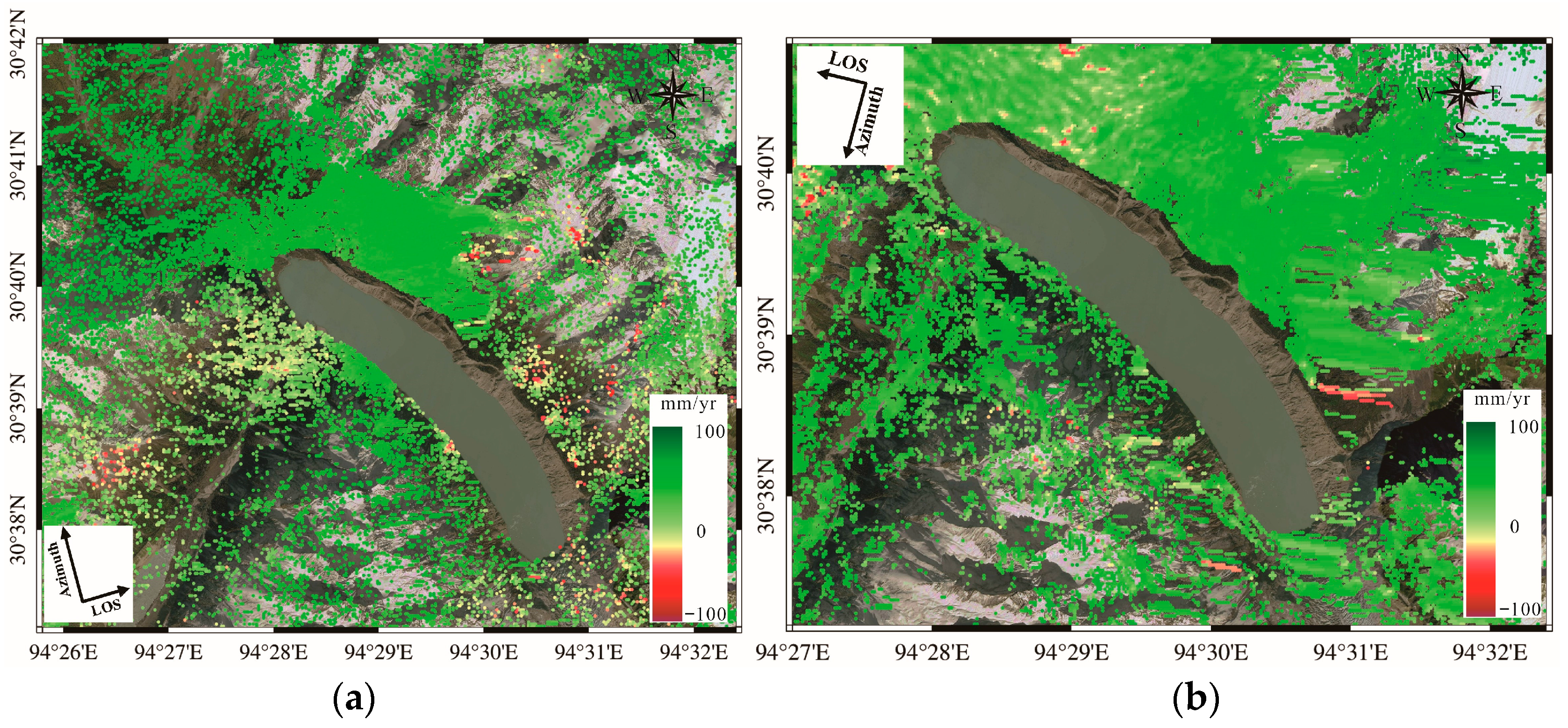
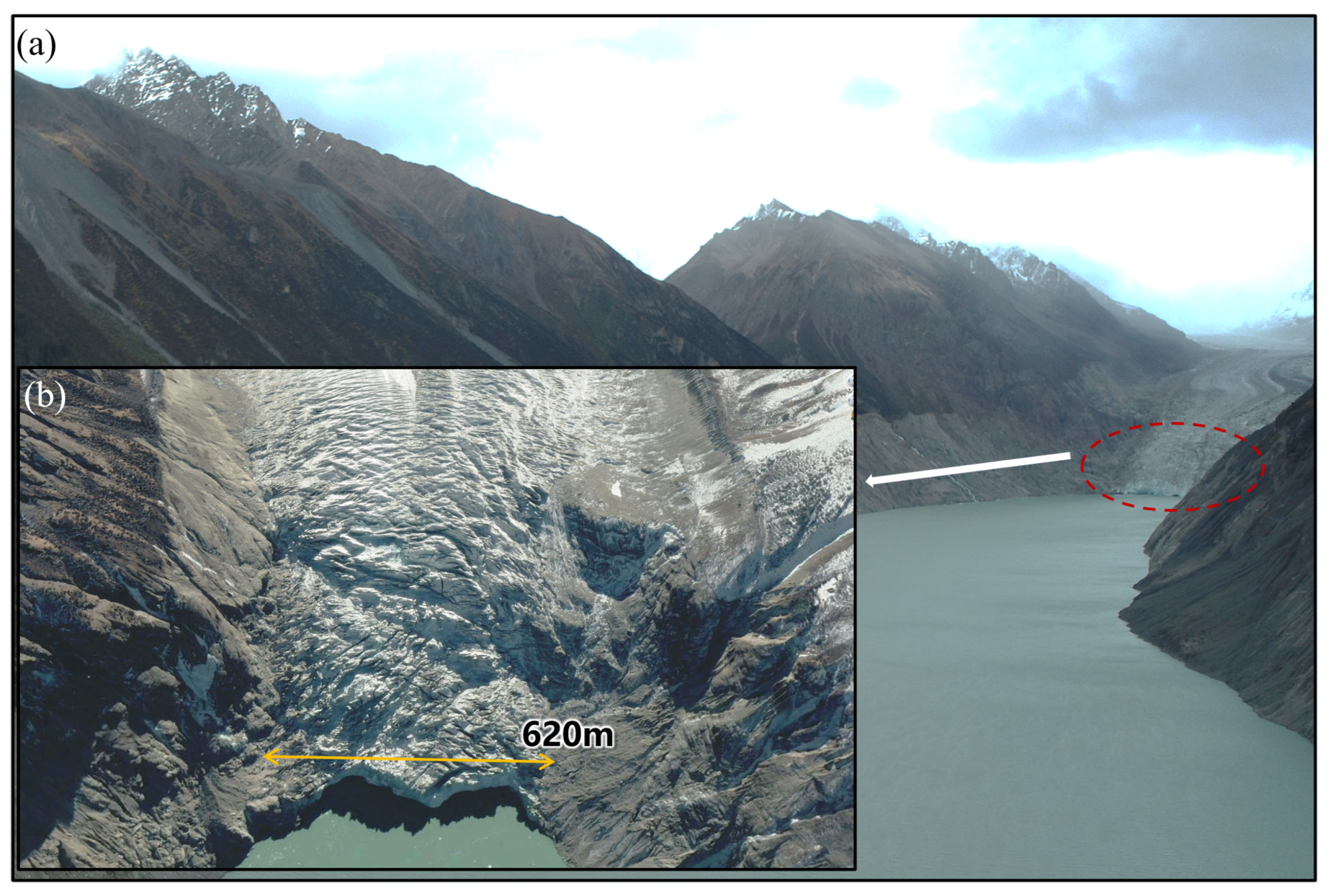
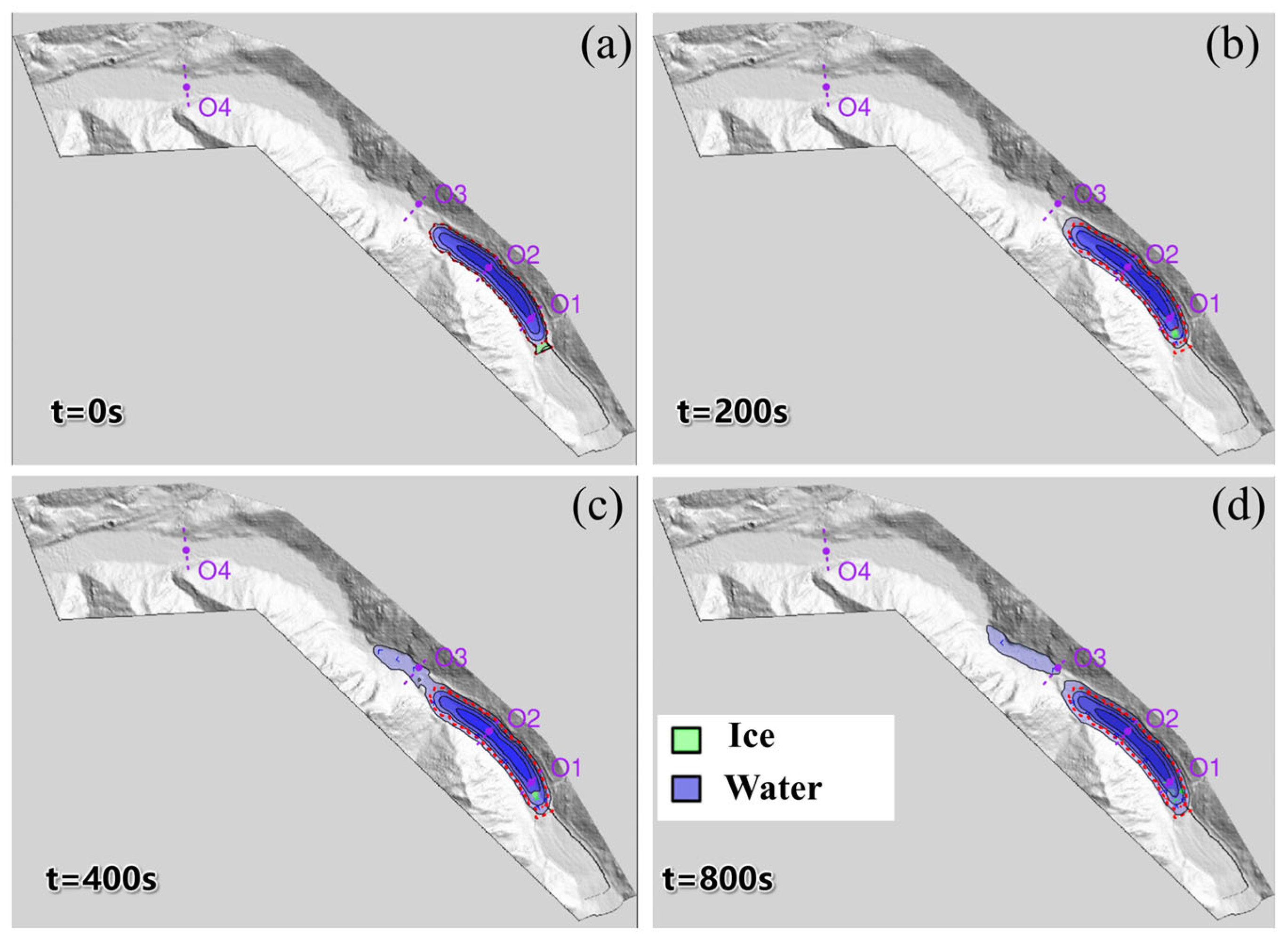
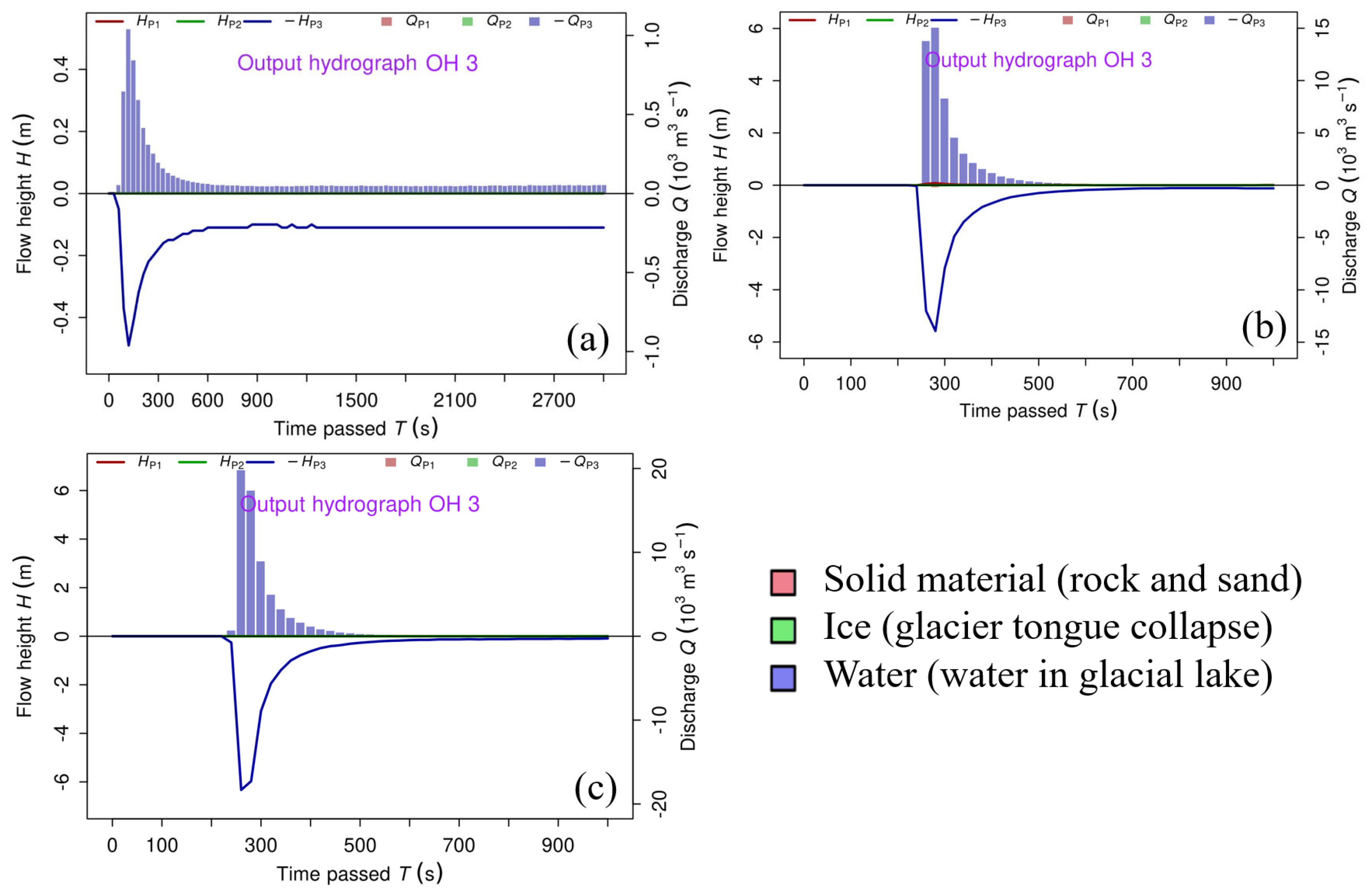
3.2. Potential Triggers of GLOF

On the Qinghai–Tibet Plateau, GLOFs are typically triggered by a range of external factors, including landslides, debris flows, ice avalanches, buried ice melt, and intense precipitation events [54,55,56,57]. Among these, the majority of documented GLOF incidents have been linked to landslides or high-elevation rock/ice avalanches. In the case of Jiongpuco Lake, the surrounding terrain features steep slopes and abundant unconsolidated moraine deposits (Figure 5), which may contribute to slope instability. Consequently, InSAR analysis was employed to detect potential surface deformation zones in the vicinity of the lake.
After excluding regions with severe decorrelation from both ascending and descending interferometric datasets, statistical analyses were performed on the remaining deformation fields. The accuracy of the InSAR-derived deformation measurements was evaluated using the annual mean velocity fields from both tracks. Results indicate that deformation rates follow a normal distribution centered near zero, and the standard deviation difference between the two datasets is significantly below the InSAR observation threshold, thereby satisfying the reliability criteria for surface deformation extraction (Figure 6).
Specifically, Figure 6a presents the annual mean deformation field from the ascending track, while Figure 6b shows the descending track result. Both datasets indicate relatively stable conditions along the reservoir banks, with localized deformation signals primarily occurring at higher elevations, attributed to seasonal snow and ice melt. No evidence of large-scale landslide activity is detected near the lake margins. A minor deformation signal is observed in the central reservoir bank region in the ascending dataset; however, this area is characterized by dense vegetation and long-term snow cover, suggesting the signal likely results from transient melt processes rather than actual ground displacement. Similarly, the descending track data reveal stability across the reservoir bank, with isolated deformation near the lake outlet and adjacent glaciers. The spatial coincidence between deformation signals and glacier extents supports the interpretation that observed displacement is predominantly due to glacier surface melt rather than active ground movement.
Given that ice avalanches are recognized as major GLOF triggers, we further investigated the condition of the glacier feeding into Jiongpuco Lake. The glacier has undergone continuous retreat and thinning in recent years, accompanied by the formation of a dense network of tensile crevasses at the terminus. These crevasses are concentrated within a ~620-m-wide frontal zone (Figure 7), representing a structurally unstable section prone to ice collapse. Ice avalanches originating from this zone may serve as the principal trigger for potential lake outburst events.

3.3. Evaluation of Moraine Dam Erodibility

On the Tibetan Plateau, GLOFs frequently involve substantial downcutting and incision of moraine dams, particularly under the influence of wave overtopping induced by sudden mass impacts. This erosional breach process can significantly amplify the volume of released water and enlarge the downstream flood-affected zone. A notable example is the 2023 South Lhonak Lake outburst in Sikkim [54], where the lake experienced a water level drop of approximately 28 m, releasing over 50 Mm3 of water and causing widespread downstream devastation. Similar erosion-driven breach mechanisms have been documented in events such as the Jinwuco and Gongbatongsha GLOFs, both associated with steep downstream gradients and highly erodible dam materials.
However, the breach dynamics at Jiongpuco Lake appear to diverge notably from these cases. Our analysis indicates that the potential for deep incision into the moraine dam is minimal (Figure 8). Two key factors support this conclusion. First, the downstream slope of the dam averages only ~1.5°, which is substantially flatter than in most previously breached glacial lakes on the plateau. This gentle gradient limits hydraulic energy and reduces sediment transport capacity. Second, field-based grain size analyses reveal that the dam structure is dominated by coarse, poorly sorted materials—primarily boulders and cobbles—with minimal fine sediment content. Such coarse textures significantly inhibit particle entrainment and channel formation under high-flow conditions, making large-scale moraine erosion or internal incision unlikely.
To quantitatively assess the erosional susceptibility of the Jiongpuco moraine dam under GLOF conditions, we employed the dimensionless Shields parameter (τ*), which characterizes the initiation of sediment motion under flowing water. The Shields number is defined as:
τ* = ρwHtanβ/((ρsρw)D90),
where ρₛ is the sediment (moraine) density (2.56 g/cm3), ρw is the density of water (1.0 g/cm3), β is the slope of the flow surface, H is the flow depth, and D is the representative particle diameter. Based on topographic measurements, the backslope of the moraine dam at Jiongpuco Lake is approximately 1.5°, corresponding to a gentle hydraulic gradient. The characteristic particle size (D90) was estimated from field-derived grain size distributions (see Figure 8) to be ~60 mm, indicating a very coarse sediment composition. Assuming typical post-overtopping flood depths ranging from 0 to 50 m, the calculated Shields number (τ*) spans from approximately 0.001 to 0.05. These values fall substantially below the empirically derived critical Shields threshold
τic = 0.143(D90/D50)−0.737
where representative particle size (D50) of the moraine dam was approximately 20 mm, referring to the GLOF event at Guangxie Co Lake in the Midui Gully of the Palong Zangbo River basin. Thus, since the critical Shields number (τic = 0.06) exceeds the calculated Shields number (τ*), it indicates that dam particles are unlikely to be entrained, making downcutting erosion and dam breach less probable. Therefore, while the likelihood of a GLOF at Jiongpuco Lake remains high, the probability of dam incision is low; considering the glacier development at the lake’s rear, the most plausible outburst mechanism is an ice avalanche–induced surge leading to wave overtopping and flood discharge.

3.4. Outburst Flood

R.avaflow was employed to simulate the full cascade of processes initiated by ice avalanches of three distinct volumes—0.5 Mm3, 2.5 Mm3 (Figure 9a), and 5.0 Mm3—leading to wave surges and moraine-dam overtopping that ultimately triggered GLOFs. Simulation results indicate that, in the 2.5 Mm3 scenario, the flood wave reached the dam crest approximately 200 s after the initial avalanche impact (Figure 9b), initiating overtopping and subsequent breach development. This short temporal lag highlights the rapid onset of cascading hazards resulting from avalanche-impulse wave interaction. The majority of the avalanche ice mass was deposited near the rear portion of the lake, rather than being transported toward the dam. This spatial deposition pattern, visualized in Figure 9d, suggests that the mechanical contribution of the ice to dam erosion was minimal. Instead, the overtopping was primarily driven by the high-energy impulse wave generated upon impact, rather than by direct ice loading at the dam face.
As the simulated flood progressed downstream, the modeled inundation extent demonstrated substantial lateral dispersion, particularly within the first few kilometers below the dam. This behavior aligns well with the geomorphology of the region, where the valley floor is relatively broad and gently sloping (as shown in Figure 8). The wide cross-sectional profile promotes lateral spreading of the flood wave, leading to rapid attenuation of both flow depth and peak discharge. These spatial dynamics emphasize the critical role of high-resolution topographic data in capturing flood propagation and underscore the value of integrating such detail in hazard modeling frameworks.
Simulation results show that the wave surge generated by the ice avalanche has limited erosive potential during propagation, with no significant entrainment or downstream transport of solid material observed across the model domain. Under the three avalanche scenarios—0.5 Mm3, 2.5 Mm3, and 5.0 Mm3—the modeled peak discharges at the breach site reached approximately 1000 m3/s, 15,000 m3/s, and 19,000 m3/s, respectively (Figure 10). Corresponding GLOF volumes were estimated at 0.2 Mm3, 1.01 Mm3, and 1.42 Mm3. Despite the high discharge rates, flood depths along the downstream channel generally ranged between 0.5 m and 6.2 m, which are considered moderate in the context of mountainous GLOFs, but still potentially hazardous, particularly in low-lying or exposed areas. This flow behavior is attributed to the smooth and uniform surface morphology of the moraine dam, which lacks pronounced topographic depressions or pre-existing breach channels. The absence of significant hydraulic concentration points effectively limits vertical erosion and restricts inundation depth, even under large volume scenarios. As a result, although peak discharges are substantial, the overall inundation hazard is relatively constrained when compared to scenarios involving deeply incised breach pathways.
The peak discharge hydrographs generated at the dam site (Figure 11) were subsequently incorporated as upstream boundary conditions in the HEC-RAS flood routing model. The resulting downstream flow hydrographs (Figure 11) and peak discharge values (Table 2) clearly demonstrate strong attenuation of flood magnitude across all three ice avalanche scenarios. At just 2 km downstream of the breach site, peak discharges had already decreased to approximately 287 m3/s, 2323 m3/s, and 2730 m3/s for the 0.5 Mm3, 2.5 Mm3, and 5.0 Mm3 scenarios, respectively, representing sharp reductions from their initial values. By 20 km, the discharges had diminished further to near-baseline flow levels, indicating a limited spatial extent of extreme flood hazard.
This rapid attenuation is primarily attributed to the geomorphic characteristics of the downstream river valley, which is defined by a gentle longitudinal gradient and a broad cross-sectional profile. These features promote lateral dispersion of floodwaters, reduce flow velocity and shear stress, and enhance temporary water storage along the floodplain, collectively mitigating downstream flood intensity. The simulation findings are consistent with previous studies (e.g., Peng et al., 2025 [49]), which report similar attenuation patterns in glacier-fed basins with low slopes and wide valleys. Overall, although the initial discharges at the dam breach are substantial, the downstream inundation hazard remains relatively constrained. These results underscore the critical influence of both dam surface morphology and valley topography in modulating GLOF impacts and reinforce the necessity of incorporating high-resolution terrain data and site-specific hydraulic conditions in hazard modeling and risk assessment frameworks.

4. Discussion

4.1. Potential for Transformation from Flood to Debris Flow

The potential for GLOF-induced debris flow largely depends on the availability and characteristics of loose solid material (sediment supply), as well as valley morphology. Although the downstream channel of Jiongpuco Lake contains glaciofluvial and alluvial deposits (Figure 8), with a channel width of approximately 1 km and slope-side accumulations of rockfall and landslide debris, the stability and spatial distribution of these materials suggest low susceptibility to mass mobilization. Moreover, the longitudinal channel gradient from the lake to Jinling Township is relatively mild—significantly lower than thresholds identified in previous studies. According to empirical criteria, debris flows are unlikely to form when channel slopes are below 30%, even in sediment-rich valleys. Comparative analysis with similar GLOF events in the region (e.g., Jinwuco, Cuoga, and Ranzeria Co) shows that the valley slope is substantially lower than those where debris flows occurred [56,57]. Despite the presence of sediment sources, the lack of steep gradients and the wide valley morphology indicate that flood energy is insufficient to entrain large volumes of debris. Therefore, under current geomorphic and hydrological conditions, it is unlikely that a GLOF from Jiongpuco Lake would evolve into a debris flow.

4.2. Rationality of Simulated Ice Avalanche Volume and Discharge Values

The avalanche volumes of 0.5, 2.5, and 5.0 Mm3 were selected based on a combination of glacier tongue geometry and empirical data from previously documented ice avalanche events. As shown in Figure 7, the glacier tongue has a width of approximately 620 m, and the height difference between the glacier crest and lake surface is about 45 m. Based on these dimensions, the selected volumes correspond to collapse lengths of roughly 18 m, 90 m, and 180 m, respectively—each representing a physically plausible failure extent under different scenarios. Furthermore, these volume values are consistent with published reports of ice avalanche events with nearly 100% ice content, such as those described by Schneider et al. (2011) [58], Schaub et al. (2016) [59], and Kääb et al. (2018) [60], which document avalanche volumes ranging from a few 0.01 Mm3 up to more than 5 Mm3. The scenario framework in Schaub et al. (2016) [59], for instance, classifies avalanche volumes into small (0.04–0.1 Mm3), medium (0.2–0.9 Mm3), and large (1–2 Mm3) categories. Therefore, the selected range in our study spans both typical and extreme conditions, capturing the potential variability in future ice avalanche events at Jiongpuco Lake.
To assess the reliability of the simulated peak discharges at the breach point, em-pirical equations from Table 3 were used for comparison across the three avalanche sce-narios. Under Scenario 0.5 Mm3, empirical estimates of peak discharge range from 142 m3/s to 1179 m3/s, with a median of 367 m3/s. For Scenario 2.5 Mm3, the estimated range is 413–2968 m3/s (median: 1040 m3/s), while Scenario 5.0 Mm3 yields 517–3604 m3/s (median: 1380 m3/s). By contrast, the R.avaflow simulations produced significantly higher peak discharge values: 1000 m3/s, 15,000 m3/s, and 19,000 m3/s for the three scenarios. The higher simulated values can be attributed to the substantial width of the moraine dam at the breach site—approximately 800 m. As shown in Figure 11, despite relatively shallow flow depths (0.5 m, 5.8 m, and 6.2 m for the three scenarios), the large cross-sectional area allows for high discharge volumes. This supports the conclusion that the simulated peak flows are reasonable given the physical dimensions and hydraulic capacity of the dam structure. Furthermore, the simulated volume of floodwater released relative to total lake volume was found to be only 0.03%, 0.15%, and 0.21% for the three scenarios. These values are significantly lower than the observed ratios of 0.64–0.89 reported in four typical GLOF cases from the Nyainqêntanglha Mountains. The likely reason for this discrepancy is that most historical GLOFs involved progressive downcutting erosion of the moraine dam, which substantially increased breach volume. In contrast, the Jiongpuco outburst is dominated by wave overtopping without significant dam incision, thereby resulting in a much smaller total flood volume.

4.3. Model Reliability and Uncertainty

No historical GLOF or ice avalanche-triggered flood has been recorded at Jiongpuco, and therefore, no direct observational data (e.g., flood marks, hydrographs, or inundation maps) are available for model calibration at this site. While both R.avaflow and HEC-RAS have been successfully applied in similar high-mountain studies, and our parameter choices are grounded in published literature, we acknowledge that uncertainties remain. To address this, we identified key sensitive parameters and conducted targeted sensitivity analyses. For R.avaflow, based on existing studies [61], the most influential parameters affecting wave generation are: (i) the volume of the mass movement entering the lake, (ii) the digital elevation model (DEM), (iii) the origin location of the mass movement, (iv) the entrainment coefficient, and (v) the basal friction angle. Among these, the avalanche volume is a scenario-defining input and is constrained using geomorphic and remote sensing evidence, as detailed in Section 4.2. The DEM quality is discussed in the methods, and we consider the resolution appropriate for the regional scale. The source location of the avalanche is fixed based on a clearly identifiable crevasse on the glacier tongue. While the entrainment coefficient and basal friction angle are harder to quantify precisely, their influence is limited in this case due to the very short runout distance from the glacier tongue to the lake. Therefore, the key parameters influencing the wave generation and dam overtopping processes are well constrained in this study, while uncertainties related to basal friction are expected to have minimal impact.
In the HEC-RAS flood model, the Manning’s roughness coefficient is a key parameter influencing flow resistance and discharge. In this study, we applied a uniform Manning’s n value of 0.03, which falls within the commonly accepted range (0.03–0.05) for steep, gravel-bed mountain rivers with vegetated floodplains [54,62,63]. Although using spatially distributed Manning coefficient based on land cover data could offer improved hydraulic realism (e.g., Uddin et al., 2015 [64]), such data are unavailable for this remote region, and field calibration is not feasible due to the lack of in-situ measurements. To assess the sensitivity of this parameter, we tested additional values of 0.04 and 0.05. The results show that variations in Manning coefficient lead to up to 15% differences in peak discharge, with values ranging from 492 m3/s (n = 0.03) to 418 m3/s (n = 0.06), and a corresponding delay in peak arrival time (Figure 12). These findings suggest that flood magnitudes may be slightly overestimated under smoother-channel assumptions.

4.4. Implications for GLOF Risk Assessment

This study provides new insights into GLOF mechanisms through an integrated approach combining remote sensing, field investigations, and numerical simulations. The case of Jiongpuco Lake illustrates a distinct outburst mode characterized by the sequence of ice avalanche-induced wave surge, wave overtopping, and flood discharge, without substantial moraine incision. Due to the low-gradient, wide downstream valley, flood peaks attenuate rapidly, reducing downstream hazard potential. In contrast, other documented GLOF events such as those at Jinwuco, Gongbatongshaco, and South Lhonak Lake in Sikkim highlight the complexity and variability of breach mechanisms [55,56]. The Jinwuco and Gongbatongshaco events involved significant dam erosion and channel incision, resulting in large flood volumes and long travel distances. The 2023 South Lhonak Lake outburst in Sikkim demonstrated a rapid water level drop (~28 m) and dam breach enlargement driven by erosion, causing severe downstream damage [54]. These cases emphasize that GLOF behavior is highly sensitive to local dam structure, slope conditions, and sediment characteristics.
These comparisons underscore the need for systematic documentation of GLOF events across the Tibetan Plateau and the Himalayas. Detailed site investigations, including sedimentological and topographic assessments, are essential to better understand breach mechanisms. Expanding the sample size of well-documented GLOF cases will enhance our capacity to model future events and develop targeted adaptation and mitigation strategies under the accelerating impacts of climate change. In addition, higher-resolution DEM data would help improve the accuracy of inundation predictions. In this study, the 30 m DEM was resampled to 10 m to enhance hydrodynamic resolution, but the results remain limited by the inherent terrain accuracy of the original data.

5. Conclusions

This study investigates the outburst flood hazard potential of the largest moraine-dammed glacial lake on the southeastern margin of the Qinghai-Tibet Plateau—Jiongpuco Lake—through integrated approaches including remote sensing imagery analysis, field investigations, InSAR deformation monitoring, and numerical simulations. The main findings are as follows:
(1)
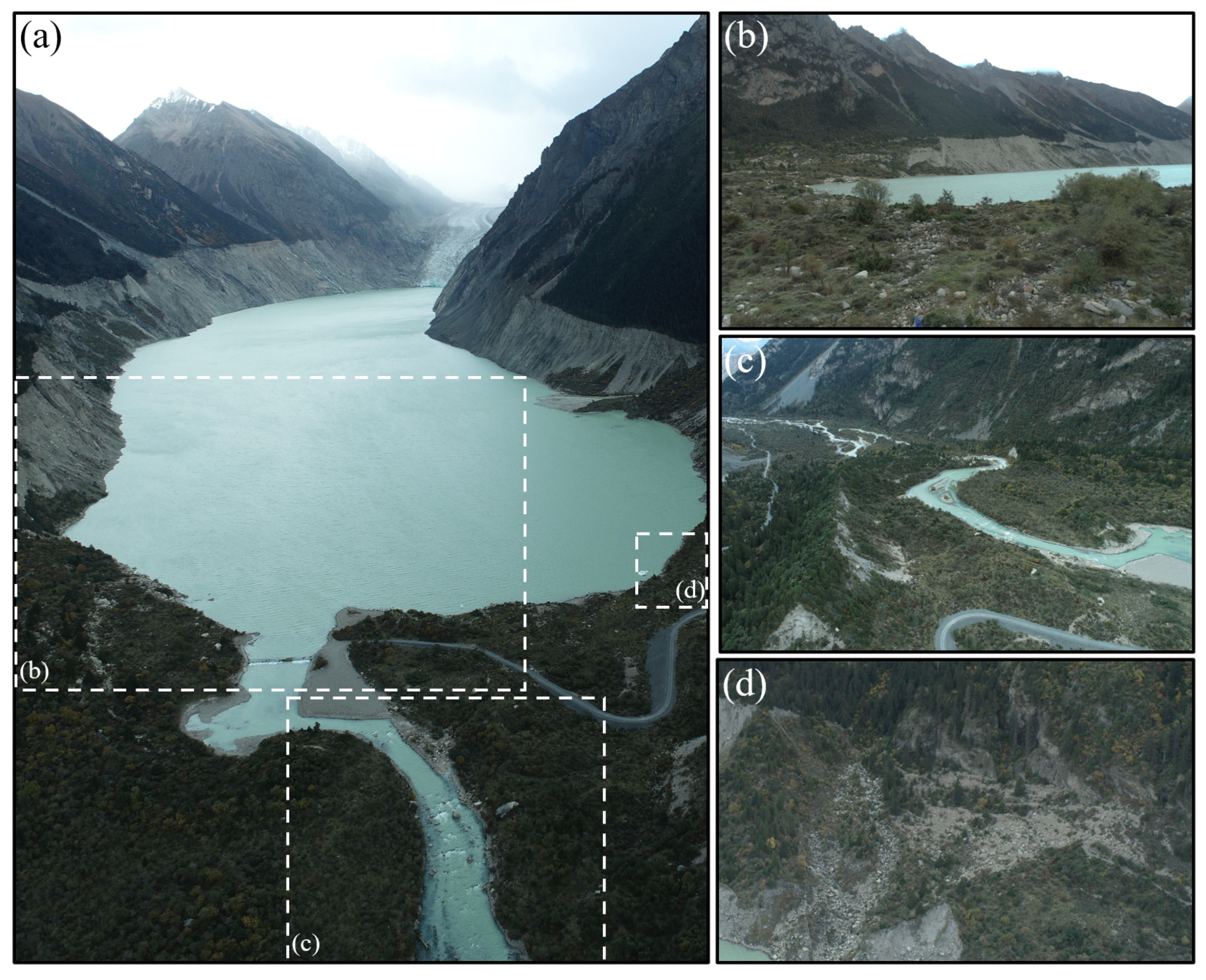
Jiongpuco Lake is situated in the Yigong Zangbo River basin, along the southeastern edge of the Qinghai-Tibet Plateau. The lake extends over 6 km in length, with an average width of approximately 300 m, covering an area of 5.43 km2. The lake area increased from 2.08 km2 in 1990 to 5.43 km2 in 2021, reflecting a total expansion of 3.35 km2. Notably, the years 2015 and 2016 witnessed the most rapid expansion, with area increases of 0.58 km2 and 0.56 km2, respectively.
(2)
Interferometric SAR (InSAR) data show minimal surface deformation along the lake margins, while crevasses in the glacier tongue indicate a high risk of ice avalanches that could generate impulse waves and trigger GLOFs. Field surveys suggest the moraine dam has a flat crest and gentle downstream slope (~1.5°), implying good structural stability. Consequently, overtopping is more likely than incision-based failure.
(3)
Simulated ice avalanche scenarios involving volumes of 0.5 Mm3, 2.5 Mm3, and 5 Mm3 yield peak discharge rates of approximately 1000 m3/s, 15,000 m3/s, and 19,000 m3/s at the dam site, respectively. These estimates are consistent with empirical formulas and comparable documented GLOF cases, supporting the reliability of the simulation results.
(4)
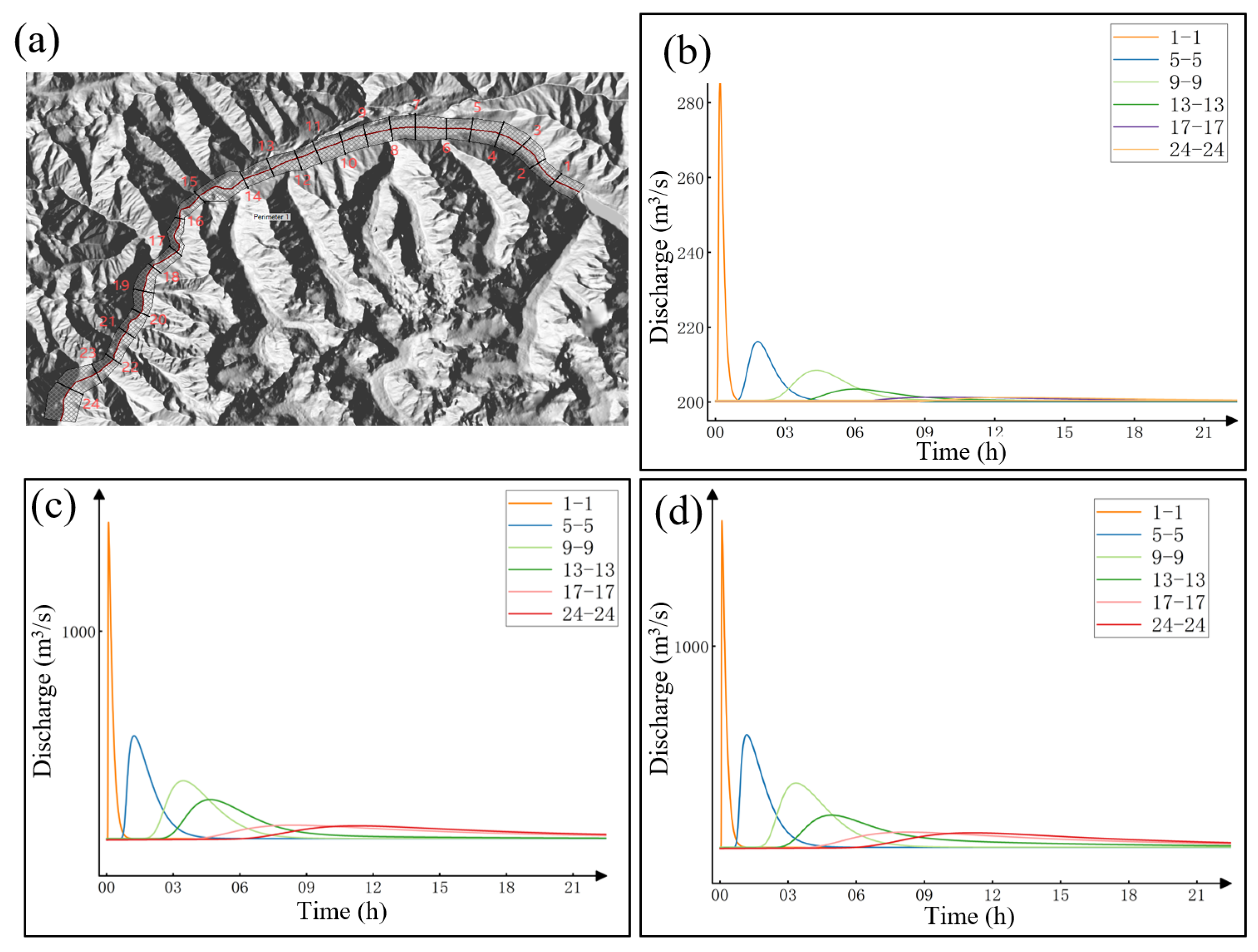
Analysis of the outburst flood routing indicates a rapid attenuation of peak discharge within the downstream river channel. At a distance of 20 km downstream, the flood peak attenuates to near-normal flow levels. This attenuation is attributed to the relatively wide and low-gradient valley downstream of Jiongpuco Lake, which facilitates dispersion and energy dissipation of floodwaters.

Author Contributions

Conceptualization, S.L. and L.L.; methodology, S.L. and C.L.; software, W.W.; formal analysis, Z.L.; writing—original draft preparation, S.L., C.L., and Z.L.; writing—review and editing, L.L.; supervision, L.L. All authors have read and agreed to the published version of the manuscript.

Funding

This research was supported by the Project of China Power Engineering Consulting Group Northwest Engineering Co., Ltd. (Grant No. XBY-ZDKJ-2023-9), and the project “Study on the Development Characteristics of Glacial Lakes in the Parlung Zangbo, Yarlung Zangbo River, and Their Impact on Cascade Hydropower Stations” (Grant No. 80303-AH20240249*3).

Data Availability Statement

The data used to support the findings of this study are available from the corresponding authors upon request.

Acknowledgments

Gratitude is extended to Chengdu University of Technology for field investigation.

Conflicts of Interest

Shuwu Li, Changhu Li, and Zhengzheng Li were employed by Northwest Engineering Corporation Limited, Power Construction Corporation. Lei Li was employed by Sichuan Highway Planning, Survey, Design and Research Institute Ltd. This study received funding from China Power Engineering Consulting Group Northwest Engineering Co., Ltd. The authors declare that the research was conducted in the absence of any commercial or financial relationships that could be construed as a potential conflict of interest. The funder was not involved in the study design, collection, analysis, interpretation of data, the writing of this article or the decision to submit it for publication.

References

  1. Yao, T.; Bolch, T.; Chen, D.; Gao, J.; Immerzeel, W.; Piao, S.; Su, F.; Thompson, L.; Wada, Y.; Wang, L. The imbalance of the Asian water tower. Nat. Rev. Earth Environ. 2022, 3, 618–632. [Google Scholar] [CrossRef]
  2. Yao, T.; Thompson, L.G.; Mosbrugger, V.; Zhang, F.; Ma, Y.; Luo, T.; Xu, B.; Yang, X.; Joswiak, D.R.; Wang, W. Third pole environment (TPE). Environ. Dev. 2012, 3, 52–64. [Google Scholar] [CrossRef]
  3. Alley, K.D.; Tang, Q. Waters From the Third Pole. Wiley Interdisciplinary Reviews. Water 2025, 12, e70007. [Google Scholar]
  4. Tang, Q.; Zhang, G.; Yao, T.; Wieland, M.; Liu, L.; Kaushik, S. Automatic extraction of glacial lakes from Landsat imagery using deep learning across the Third Pole region. Remote Sens. Environ. 2024, 315, 114413. [Google Scholar] [CrossRef]
  5. Jiang, L.; Fan, X.; Deng, Y.; Zou, C.; Feng, Z.; Djukem, D.L.W.; Wei, T.; Dou, X.; Xu, Q. Combining geophysics, remote sensing and numerical simulation to assess GLOFs: Case study of the Namulacuo Lake in the Southeastern Tibetan Plateau. Sci. Total Environ. 2023, 880, 163262. [Google Scholar] [CrossRef]
  6. Ren, S.; Jia, L.; Miles, E.S.; Menenti, M.; Kneib, M.; Shaw, T.E.; Buri, P.; McCarthy, M.J.; Yang, W.; Pellicciotti, F. Observed and projected declines in glacier albedo across the Third Pole in the 21st century. One Earth 2024, 7, 1587–1599. [Google Scholar] [CrossRef]
  7. Nie, Y.; Pritchard, H.D.; Liu, Q.; Hennig, T.; Wang, W.; Wang, X.; Liu, S.; Nepal, S.; Samyn, D.; Hewitt, K. Glacial change and hydrological implications in the Himalaya and Karakoram. Nat. Rev. Earth Environ. 2021, 2, 91–106. [Google Scholar] [CrossRef]
  8. Zhou, Y.; Li, Z.; Li, J.; Zhao, R.; Ding, X. Glacier mass balance in the Qinghai–Tibet Plateau and its surroundings from the mid-1970s to 2000 based on Hexagon KH-9 and SRTM DEMs. Remote Sens. Environ. 2018, 210, 96–112. [Google Scholar] [CrossRef]
  9. Brun, F.; Berthier, E.; Wagnon, P.; Kääb, A.; Treichler, D. A spatially resolved estimate of High Mountain Asia glacier mass balances from 2000 to 2016. Nat. Geosci. 2017, 10, 668–673. [Google Scholar] [CrossRef] [PubMed]
  10. Dowdeswell, J.A.; Hagen, J.O.; Björnsson, H.; Glazovsky, A.F.; Harrison, W.D.; Holmlund, P.; Jania, J.; Koerner, R.M.; Lefauconnier, B.; Ommanney, C.S.L. The mass balance of circum-Arctic glaciers and recent climate change. Quat. Res. 1997, 48, 1–14. [Google Scholar] [CrossRef]
  11. Wang, W.; Xiang, Y.; Gao, Y.; Lu, A.; Yao, T. Rapid expansion of glacial lakes caused by climate and glacier retreat in the Central Himalayas. Hydrol. Process. 2015, 29, 859–874. [Google Scholar] [CrossRef]
  12. Song, C.; Sheng, Y.; Ke, L.; Nie, Y.; Wang, J. Glacial lake evolution in the southeastern Tibetan Plateau and the cause of rapid expansion of proglacial lakes linked to glacial-hydrogeomorphic processes. J. Hydrol. 2016, 540, 504–514. [Google Scholar] [CrossRef]
  13. Song, C.; Huang, B.; Richards, K.; Ke, L.; Hien Phan, V. Accelerated lake expansion on the Tibetan Plateau in the 2000s: Induced by glacial melting or other processes? Water Resour. Res. 2014, 50, 3170–3186. [Google Scholar] [CrossRef]
  14. Dou, X.; Fan, X.; Wang, X.; Yunus, A.P.; Xiong, J.; Tang, R.; Lovati, M.; van Westen, C.; Xu, Q. Spatio-temporal evolution of glacial lakes in the Tibetan Plateau over the past 30 years. Remote Sens. 2023, 15, 416. [Google Scholar] [CrossRef]
  15. Sun, J.; Zhou, T.; Liu, M.; Chen, Y.; Shang, H.; Zhu, L.; Shedayi, A.A.; Yu, H.; Cheng, G.; Liu, G. Linkages of the dynamics of glaciers and lakes with the climate elements over the Tibetan Plateau. Earth-Sci. Rev. 2018, 185, 308–324. [Google Scholar] [CrossRef]
  16. Shijin, W.; Yanjun, C.; Yanqiang, W. Spatiotemporal dynamic characteristics of typical temperate glaciers in China. Sci. Rep. 2021, 11, 657. [Google Scholar] [CrossRef]
  17. Chen, F.; Zhang, M.; Guo, H.; Allen, S.; Kargel, J.S.; Haritashya, U.K.; Watson, C.S. Annual 30 m dataset for glacial lakes in High Mountain Asia from 2008 to 2017. Earth Syst. Sci. Data 2021, 13, 741–766. [Google Scholar] [CrossRef]
  18. Wang, X.; Guo, X.; Yang, C.; Liu, Q.; Wei, J.; Zhang, Y.; Liu, S.; Zhang, Y.; Jiang, Z.; Tang, Z. Glacial lake inventory of high-mountain Asia in 1990 and 2018 derived from Landsat images. Earth Syst. Sci. Data 2020, 12, 2169–2182. [Google Scholar] [CrossRef]
  19. Zhang, M.; Chen, F.; Guo, H.; Yi, L.; Zeng, J.; Li, B. Glacial Lake area changes in high mountain asia during 1990–2020 using satellite remote sensing. Research 2022, 2022, 9821275. [Google Scholar] [CrossRef]
  20. Dou, X.; Fan, X.; Wang, X.; Fang, C.; Lovati, M.; Zou, C. The response of glaciers and glacial lakes to climate change in the Southeastern Tibetan Plateau over the past three decades. Land Degrad. Dev. 2023, 34, 5675–5696. [Google Scholar] [CrossRef]
  21. Wang, X.; Siegert, F.; Zhou, A.-g.; Franke, J. Glacier and glacial lake changes and their relationship in the context of climate change, Central Tibetan Plateau 1972–2010. Glob. Planet. Change 2013, 111, 246–257. [Google Scholar] [CrossRef]
  22. Nie, Y.; Sheng, Y.; Liu, Q.; Liu, L.; Liu, S.; Zhang, Y.; Song, C. A regional-scale assessment of Himalayan glacial lake changes using satellite observations from 1990 to 2015. Remote Sens. Environ. 2017, 189, 1–13. [Google Scholar] [CrossRef]
  23. Mingwei, Y.; Yonggang, G.; Jian, Z.; Feng, L.; Libin, S.; Deshun, Q. Spaciotemporal distribution characteristics of glacial lakes and the factors influencing the Southeast Tibetan Plateau from 1993 to 2023. Sci. Rep. 2025, 15, 1966. [Google Scholar] [CrossRef] [PubMed]
  24. Zheng, G.; Allen, S.K.; Bao, A.; Ballesteros-Cánovas, J.A.; Huss, M.; Zhang, G.; Li, J.; Yuan, Y.; Jiang, L.; Yu, T. Increasing risk of glacial lake outburst floods from future Third Pole deglaciation. Nat. Clim. Change 2021, 11, 411–417. [Google Scholar] [CrossRef]
  25. Wang, S.; Che, Y.; Xinggang, M. Integrated risk assessment of glacier lake outburst flood (GLOF) disaster over the Qinghai–Tibetan Plateau (QTP). Landslides 2020, 17, 2849–2863. [Google Scholar] [CrossRef]
  26. Taylor, C.; Robinson, T.R.; Dunning, S.; Rachel Carr, J.; Westoby, M. Glacial lake outburst floods threaten millions globally. Nat. Commun. 2023, 14, 487. [Google Scholar] [CrossRef]
  27. Carrivick, J.L.; Tweed, F.S. A global assessment of the societal impacts of glacier outburst floods. Glob. Planet. Change 2016, 144, 1–16. [Google Scholar] [CrossRef]
  28. Veh, G.; Korup, O.; Walz, A. Hazard from Himalayan glacier lake outburst floods. Proc. Natl. Acad. Sci. USA 2020, 117, 907–912. [Google Scholar] [CrossRef]
  29. Veh, G.; Lützow, N.; Kharlamova, V.; Petrakov, D.; Hugonnet, R.; Korup, O. Trends, breaks, and biases in the frequency of reported glacier lake outburst floods. Earth’s Future 2022, 10, e2021EF002426. [Google Scholar] [CrossRef]
  30. Shrestha, F.; Steiner, J.F.; Shrestha, R.; Dhungel, Y.; Joshi, S.P.; Inglis, S.; Ashraf, A.; Wali, S.; Walizada, K.M.; Zhang, T. A comprehensive and version-controlled database of glacial lake outburst floods in High Mountain Asia. Earth Syst. Sci. Data 2023, 15, 3941–3961. [Google Scholar] [CrossRef]
  31. Aggarwal, S.; Rai, S.; Thakur, P.; Emmer, A. Inventory and recently increasing GLOF susceptibility of glacial lakes in Sikkim, Eastern Himalaya. Geomorphology 2017, 295, 39–54. [Google Scholar] [CrossRef]
  32. Khadka, N.; Chen, X.; Nie, Y.; Thakuri, S.; Zheng, G.; Zhang, G. Evaluation of Glacial Lake Outburst Flood susceptibility using multi-criteria assessment framework in Mahalangur Himalaya. Front. Earth Sci. 2021, 8, 601288. [Google Scholar] [CrossRef]
  33. Zhang, D.; Zhou, G.; Li, W.; Han, L.; Zhang, S.; Yao, X.; Duan, H. A robust glacial lake outburst susceptibility assessment approach validated by GLOF event in 2020 in the Nidu Zangbo Basin, Tibetan Plateau. Catena 2023, 220, 106734. [Google Scholar] [CrossRef]
  34. Vogel, K.; Sieg, T.; Veh, G.; Fiedler, B.; Moran, T.; Peter, M.; Rottler, E.; Bronstert, A. Natural hazards in a changing world: Methods for analyzing trends and non-linear changes. Earth’s Future 2024, 12, e2023EF003553. [Google Scholar] [CrossRef]
  35. Chen, H.; Liang, Q.; Zhao, J.; Maharjan, S.B. Assessing national exposure and impact to glacial lake outburst floods considering uncertainty under data sparsity. Hydrol. Earth Syst. Sci. Discuss. 2024, 2024, 1–30. [Google Scholar] [CrossRef]
  36. Chen, H.; Zhao, J.; Liang, Q.; Maharjan, S.B.; Joshi, S.P. Assessing the potential impact of glacial lake outburst floods on individual objects using a high-performance hydrodynamic model and open-source data. Sci. Total Environ. 2022, 806, 151289. [Google Scholar] [CrossRef]
  37. Khadka, N.; Chen, X.; Liu, W.; Gouli, M.R.; Zhang, C.; Shrestha, B.; Sharma, S. Glacial lake outburst floods threaten China-Nepal connectivity: Synergistic study of remote sensing, GIS and hydrodynamic modeling with regional implications. Sci. Total Environ. 2024, 948, 174701. [Google Scholar] [CrossRef]
  38. Khadka, N.; Chen, X.; Shrestha, M.; Liu, W. Risk perception and vulnerability of communities in Nepal to transboundary glacial lake outburst floods from Tibet, China. Int. J. Disaster Risk Reduct. 2024, 107, 104476. [Google Scholar] [CrossRef]
  39. Chen, X.-q.; Cui, P.; Li, Y.; Yang, Z.; Qi, Y.-q. Changes in glacial lakes and glaciers of post-1986 in the Poiqu River basin, Nyalam, Xizang (Tibet). Geomorphology 2007, 88, 298–311. [Google Scholar] [CrossRef]
  40. Wang, W.; Gao, Y.; Anacona, P.I.; Lei, Y.; Xiang, Y.; Zhang, G.; Li, S.; Lu, A. Integrated hazard assessment of Cirenmaco glacial lake in Zhangzangbo valley, Central Himalayas. Geomorphology 2018, 306, 292–305. [Google Scholar] [CrossRef]
  41. Liu, M.; Chen, N.; Zhang, Y.; Deng, M. Glacial lake inventory and lake outburst flood/debris flow hazard assessment after the Gorkha earthquake in the Bhote Koshi Basin. Water 2020, 12, 464. [Google Scholar] [CrossRef]
  42. Sattar, A.; Haritashya, U.K.; Kargel, J.S.; Karki, A. Transition of a small Himalayan glacier lake outburst flood to a giant transborder flood and debris flow. Sci. Rep. 2022, 12, 12421. [Google Scholar] [CrossRef]
  43. Yuan, Z.; Wang, R.; Zhou, W.; Chen, N.; Liu, R.; Mao, J.; Wang, T. Expanding glacial lakes and assessing outburst susceptibility of moraine-dammed lakes using logistic regression in the Yigong Tsangpo Basin, Tibet, China. Nat. Hazards 2025, 121, 6753–6776. [Google Scholar] [CrossRef]
  44. Yang, W.; Wang, Z.; An, B.; Chen, Y.; Zhao, C.; Li, C.; Wang, Y.; Wang, W.; Li, J.; Wu, G. Early warning system for ice collapses and river blockages in the Sedongpu Valley, southeastern Tibetan Plateau. Nat. Hazards Earth Syst. Sci. 2023, 23, 3015–3029. [Google Scholar] [CrossRef]
  45. Hu, J.; Zhang, T.; Zhou, X.; Yi, G.; Bie, X.; Li, J.; Chen, Y.; Lai, P. A glacial lake mapping framework in high mountain areas: A case study of the southeastern Tibetan plateau. IEEE Trans. Geosci. Remote Sens. 2024, 62, 1–12. [Google Scholar] [CrossRef]
  46. Wang, P.; Wang, H.; Hu, G.; Liu, T.; Li, C.; Qin, J.; Ge, Y. Glacier dam evolution and knickpoint migration in the Yarlung Tsangpo Gorge, eastern Himalayas, since the last glacial period. Quat. Sci. Rev. 2024, 331, 108631. [Google Scholar] [CrossRef]
  47. Guo, R.; Jiang, L.; Xu, Z.; Li, C.; Huang, R.; Zhou, Z.; Li, T.; Liu, Y.; Wang, H.; Fan, X. Seismic and hydrological triggers for a complex cascading geohazard of the Tianmo Gully in the southeastern Tibetan Plateau. Eng. Geol. 2023, 324, 107269. [Google Scholar] [CrossRef]
  48. Chen, C.; Zhang, L.; Xiao, T.; He, J. Barrier lake bursting and flood routing in the Yarlung Tsangpo Grand Canyon in October 2018. J. Hydrol. 2020, 583, 124603. [Google Scholar] [CrossRef]
  49. Peng, T.; Chen, N.; Pudasaini, S.P.; Mergili, M.; Wang, T.; Liu, M.; Shangguan, D. Risk assessment of a glacial lake with abruptly slowing expansion, Jiongpu, Southeastern Tibet. Geomorphology 2025, 468, 109471. [Google Scholar] [CrossRef]
  50. Zhang, G.; Bolch, T.; Yao, T.; Rounce, D.R.; Chen, W.; Veh, G.; King, O.; Allen, S.K.; Wang, M.; Wang, W. Underestimated mass loss from lake-terminating glaciers in the greater Himalaya. Nat. Geosci. 2023, 16, 333–338. [Google Scholar] [CrossRef]
  51. Cook, S.; Quincey, D. Estimating the volume of Alpine glacial lakes. Earth Surf. Dyn. 2015, 3, 559–575. [Google Scholar] [CrossRef]
  52. Yang, L.; Lu, Z.; Ouyang, C.; Zhao, C.; Hu, X.; Zhang, Q. Glacial lake outburst flood monitoring and modeling through integrating multiple remote sensing methods and hec-ras. Remote Sens. 2023, 15, 5327. [Google Scholar] [CrossRef]
  53. Mergili, M.; Fischer, J.-T.; Krenn, J.; Pudasaini, S.P. r. avaflow v1, an advanced open-source computational framework for the propagation and interaction of two-phase mass flows. Geosci. Model Dev. 2017, 10, 553–569. [Google Scholar] [CrossRef]
  54. Sattar, A.; Cook, K.L.; Rai, S.K.; Berthier, E.; Allen, S.; Rinzin, S.; de Vries, M.V.W.; Haeberli, W.; Kushwaha, P.; Shugar, D.H. The Sikkim flood of October 2023: Drivers, causes, and impacts of a multihazard cascade. Science 2025, 387, eads2659. [Google Scholar] [CrossRef]
  55. Cook, K.L.; Andermann, C.; Gimbert, F.; Adhikari, B.R.; Hovius, N. Glacial lake outburst floods as drivers of fluvial erosion in the Himalaya. Science 2018, 362, 53–57. [Google Scholar] [CrossRef]
  56. Zheng, G.; Mergili, M.; Emmer, A.; Allen, S.; Bao, A.; Guo, H.; Stoffel, M. The 2020 glacial lake outburst flood at Jinwuco, Tibet: Causes, impacts, and implications for hazard and risk assessment. Cryosphere Discuss. 2021, 2021, 1–28. [Google Scholar] [CrossRef]
  57. Peng, M.; Wang, X.; Zhang, G.; Veh, G.; Sattar, A.; Chen, W.; Allen, S. Cascading hazards from two recent glacial lake outburst floods in the Nyainqêntanglha range, Tibetan Plateau. J. Hydrol. 2023, 626, 130155. [Google Scholar] [CrossRef]
  58. Schneider, D.; Huggel, C.; Haeberli, W.; Kaitna, R. Unraveling driving factors for large rock–ice avalanche mobility. Earth Surf. Process. Landf. 2011, 36, 1948–1966. [Google Scholar] [CrossRef]
  59. Schaub, Y.S.; Huggel, C.; Cochachin, A. Ice-avalanche scenario elaboration and uncertainty propagation in numerical simulation of rock-/ice-avalanche-induced impact waves at Mount Hualcán and Lake 513, Peru. Landslides 2016, 13, 1445–1459. [Google Scholar] [CrossRef]
  60. Kääb, A.; Leinss, S.; Gilbert, A.; Bühler, Y.; Gascoin, S.; Evans, S.G.; Bartelt, P.; Berthier, E.; Brun, F.; Chao, W.-A. Massive collapse of two glaciers in western Tibet in 2016 after surge-like instability. Nat. Geosci. 2018, 11, 114–120. [Google Scholar] [CrossRef]
  61. Rinzin, S.; Dunning, S.; Carr, R.J.; Sattar, A.; Mergili, M. Exploring implications of input parameter uncertainties in glacial lake outburst flood (GLOF) modelling results using the modelling code r. avaflow. Nat. Hazards Earth Syst. Sci. 2025, 25, 1841–1864. [Google Scholar] [CrossRef]
  62. Westoby, M.J.; Brasington, J.; Glasser, N.; Hambrey, M.; Reynolds, J.M.; Hassan, M.A.; Lowe, A. Numerical modelling of glacial lake outburst floods using physically based dam-breach models. Earth Surf. Dyn. 2015, 3, 171–199. [Google Scholar] [CrossRef]
  63. Wang, Q.; Duan, H.; Liu, N.; Du, Z.; Wang, P.; Yi, B.; Xu, J.; Huang, J.; Zhang, Y.; Yao, X. Change of moraine-dammed glacial lakes and simulation of glacial lake outburst flood in the Yi’ong Zangbo River basin. Front. Earth Sci. 2022, 10, 881285. [Google Scholar] [CrossRef]
  64. Uddin, K.; Shrestha, H.L.; Murthy, M.; Bajracharya, B.; Shrestha, B.; Gilani, H.; Pradhan, S.; Dangol, B. Development of 2010 national land cover database for the Nepal. J. Environ. Manag. 2015, 148, 82–90. [Google Scholar] [CrossRef]
Figure 1. Overview of Jiongpuco. (a) Geographical location of Jiongpuco and digital elevation model (DEM) of this area. (b) An enlarged view showing the surroundings of the lake. (c) Variation of Jiongpuco over the years.
Water 17 02102 g001
Figure 2. SBAS-InSAR data processing workflow.
Water 17 02102 g002
Figure 3. Changes in lake contour over the years.
Water 17 02102 g003
Figure 4. Changes in (a) lake area and (b) volume over the years.
Water 17 02102 g004
Figure 5. Lateral moraines due to glacier retreat: (a) north side; (b) south side. Red dashed line represents the boundary of moraines with the mountain.
Water 17 02102 g005
Figure 6. Annual mean deformation rate from ascending (a) and descending (b) tracks.
Water 17 02102 g006
Figure 7. Tensile crevasses at the glacier tongue. (a) Photo of the glacier tongue; (b) crevasses on the glacier tongue from Google Earth.
Water 17 02102 g007
Figure 8. Photographs of the glacial lake moraine dam. (a) Panorama of the entire dam; (b) View of the dam towards the lake; (c) Downstream view of the dam; (d) Western side of the dam.
Water 17 02102 g008
Figure 9. (ad) Wave surge propagation at different time steps (5 Mm3 scenario). O1, O2, O3, and O4 represent observation points located at the ice avalanche source, the middle of the lake, the dam site, and a nearby residential area, respectively.
Water 17 02102 g009
Figure 10. Wave surge height and discharge at the dam site under different scenarios. Ice avalanche volume: (a) 0.5 Mm3; (b) 2.5 Mm3; (c) 5.0 Mm3.
Water 17 02102 g010
Figure 11. GLOF propagation maps. (a) Locations of flow monitoring cross-sections used in the HEC-RAS simulation; (b) flood propagation for a 0.5 Mm3 ice avalanche scenario; (c) flood propagation for a 2.5 Mm3 ice avalanche scenario; (d) flood propagation for a 5.0 Mm3 ice avalanche scenario.
Water 17 02102 g011
Figure 12. Uncertainty analysis of the Manning coefficient.
Water 17 02102 g012
Table 1. Sentinel-1A satellite parameter information.
Parameter TypeBasic Parameters
Incidence Angle (°)33.85/43.93
Orbit DirectionAscending/Descending
Polarization ModeVV + VH
Imaging ModeIW
Spatial Resolution (m)5 × 20
Orbit Number (Ascending/Descending)70/4
Flight Azimuth (Ascending/Descending, °)−10.63/−170.19
Number of Images (Ascending/Descending)83/103
Table 2. Discharge information at different cross-sections under various scenarios (unit: m3/s).
Cross Section
Number
Distance to Dam (km)Scenario
0.5 Mm3
Scenario
2.5 Mm3
Scenario
5.0 Mm3
1-12.0028723252730
5-510.50216444492
9-918.50208314334
13-1327.00203271259
17-1739.00201222226
24-2455.00201221225
Table 3. Formula for estimating peak flow based on the outburst water volume (unit: m3/s).
NumberFormula [56]Scenario 0.5 Mm3Scenario 2.5 Mm3Scenario 5.0 Mm3
1 Q G D = 1.776 V G L O F 0.47 551 1179 1384
2 Q G D = 0.72 V G L O F 0.53 464 1096 1312
3 Q G D = 0.0048 V G L O F 0.896 270 1151 1562
4 Q G D = 0.045 V G L O F 0.66 142 413 517
5 Q G D = 0.00077 V G L O F 1.017 190 984 1391
6 Q G D = 1.122 V G L O F 0.57 1179 2968 3604
Disclaimer/Publisher’s Note: The statements, opinions and data contained in all publications are solely those of the individual author(s) and contributor(s) and not of MDPI and/or the editor(s). MDPI and/or the editor(s) disclaim responsibility for any injury to people or property resulting from any ideas, methods, instructions or products referred to in the content.

