Article

Analysis of the Intermittent Characteristics of Streamflow in Taiwan

Department of Resources Engineering, National Cheng Kung University, Tainan 701, Taiwan
*
Author to whom correspondence should be addressed.
Water 2025, 17(14), 2090; https://doi.org/10.3390/w17142090
Submission received: 14 June 2025 / Revised: 10 July 2025 / Accepted: 11 July 2025 / Published: 13 July 2025
(This article belongs to the Section Hydrology)

Abstract

More than half of the world’s rivers are intermittent, and climate change is increasing their intermittency, affecting water resources and ecosystems. In Taiwan, steep topography and uneven rainfall have led to increased intermittency in some areas, reflecting changes in hydrological conditions. Using streamflow data, this study applied intermittency ratio (IR), modified 6-month dry period seasonality (SD6), and trend analysis, as well as watershed properties and climate indices. Results showed that 92% of stations had low flows for less than 20% of the time. The dry season was mainly from November to April, and intermittency was spatially affected mainly by upstream soil moisture, moderately by potential evapotranspiration and infiltration, and less by actual evapotranspiration and catchment area. Intermittency increased in the east and decreased in the west. It was negatively correlated with upstream soil moisture and strongly associated with rainfall frequency, especially the proportion of days with precipitation less than 1 mm. These patterns highlight regional differences in river responses to climate.

1. Introduction

Intermittent rivers are defined as a type of non-perennial river characterized by periodic cessation of flow or drying up at specific times or locations. These rivers are closely connected to groundwater and exhibit variable wetting and dry phases, with flow durations extending beyond single rainfall events. From a long-term flow perspective, water is present most of the time [1]. Intermittent rivers are not only found in drought-prone regions such as Mediterranean and continental climates [2], but flow intermittency is also observed in humid climate areas [3]. Currently, approximately 51–60% of rivers worldwide experience at least 1 day of flow cessation annually [4], indicating that non-perennial rivers represent a common river type on Earth. Intermittency can be used to describe the condition of a river, where a decrease in the duration of flowing water or an increase in dry periods is considered an increase in river intermittency [3,5,6,7,8,9,10,11]. The spatial and temporal patterns of flow intermittency can vary greatly due to natural geographic factors. The literature on intermittent river characteristics indicates that spatial proximity plays a role [12]. At large scales, such as global or multi-country levels, climatic factors mainly govern the spatial and temporal variability of intermittency. These factors include aridity index (AI) and mean winter temperature (MWT) [3,4,13,14]. In contrast, at smaller scales, such as within individual catchments, the influence of climatic factors is diminished, making non-climatic factors the most relevant explanations, including catchment area, slope, geological features, and permeability [10,15,16]. However, the interaction of different catchment attributes and driving factors, including sometimes very different climates, can result in similar or equivalent flow behaviors, causing catchments with comparable hydrological characteristics to be located far apart [12].
River characteristics are subject to change due to climate change [7,16,17], which can alter the flow dynamics of non-perennial rivers. For example, some intermittent rivers experience increased intermittency due to longer dry periods, causing them to become more ephemeral [7]. As river intermittency increases, it can result in adverse impacts on water resources and ecological systems [7,11,18,19,20]. Conversely, other rivers may become perennial due to different flow cessation mechanisms, such as freezing or geological conditions [3,14,21]. Therefore, understanding the spatial and temporal variability of intermittency is critical for achieving effective ecological protection and river management.
In Taiwan, although rainfall distribution is uneven in both space and time, and rivers generally exhibit short and steep characteristics [22,23], Chen et al. [24] reported that the intermittency of rivers in the middle and lower reaches mostly shows low annual average intermittency rates at most sites with no significant temporal changes. However, an increasing trend in intermittency is observed in the eastern region, while the western region shows a decreasing trend. To better understand the spatial and temporal patterns driving the differences in river intermittency across Taiwan, this study aims to: (i) analyze the catchment attributes upstream of flow gauging stations to identify the factors causing spatial variability in intermittency among different catchments; and (ii) investigate the climatic characteristics responsible for the contrasting temporal trends of intermittency between the eastern and western regions. The findings are intended to provide a reference for river and water resource management in Taiwan. Additionally, Chen et al. [24] found that low-flow events predominantly occur during the dry season when considering entire months. However, directional statistical analysis revealed that at a few sites, the median low-flow period falls between May and October, a time characterized by more frequent rainfall events. To address this, the present study proposes a modified simplified calculation formula designed to quantify the concentration of low-flow occurrences during the dry season while also distinguishing whether low flows are concentrated in an extended summer period or an extended winter period.

2. Materials and Methods
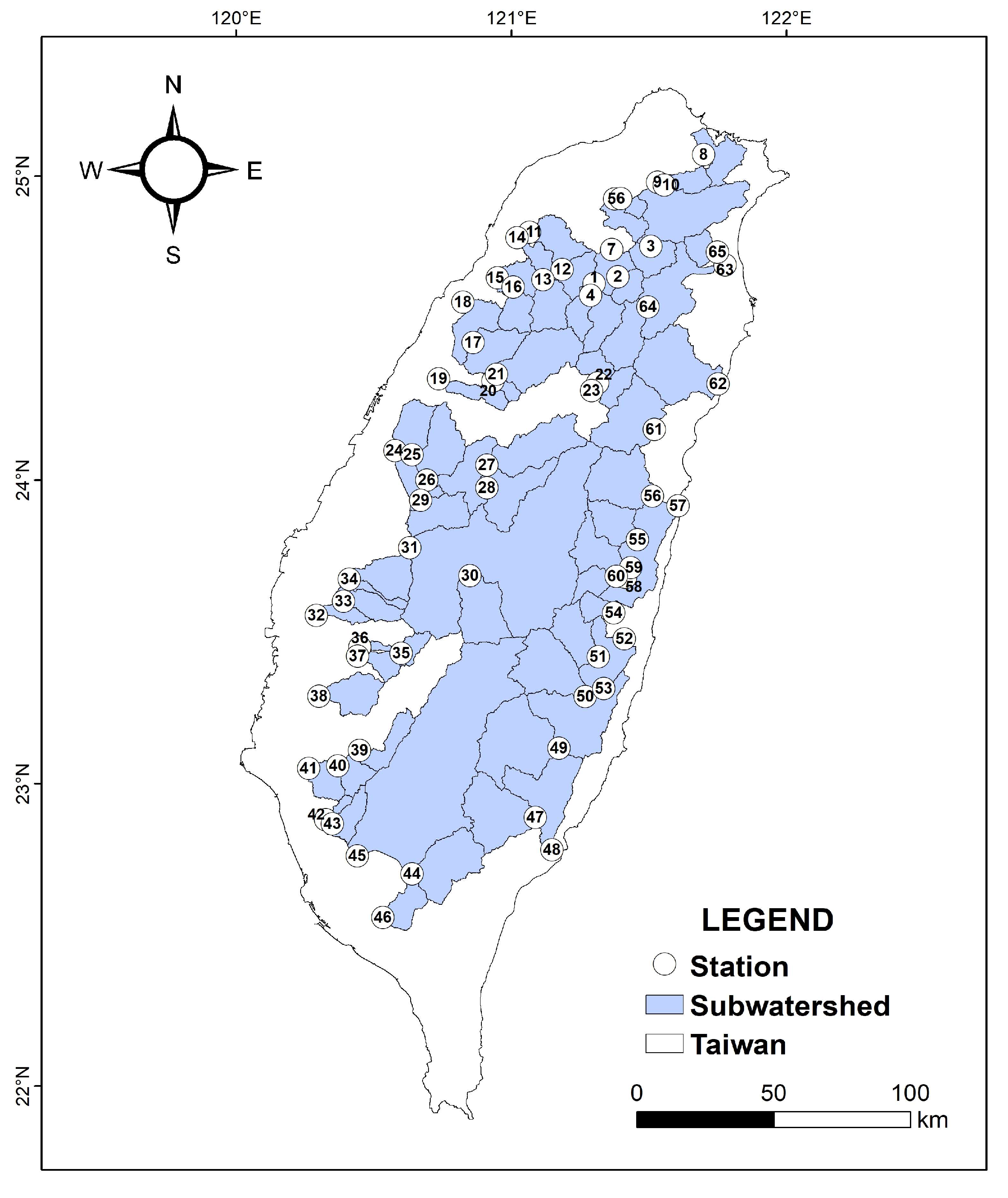
2.1. Study Area

Taiwan, located at the boundary of the Eurasian and Pacific plates, is tectonically active and crossed by the Tropic of Cancer. It has a humid subtropical climate (Cwa and Cfa) under the Köppen-Geiger classification [25,26], with an average annual rainfall of about 2,500 mm. Rainfall is concentrated in the plum rain (May–July) and typhoon (July–September) seasons, while droughts often occur in spring. The Central Range divides watersheds, with rivers flowing east to the Pacific or west to the Taiwan Strait. These rivers are short, steep, and respond quickly to rainfall. Despite abundant rainfall, steep slopes and limited channel storage result in high runoff variability and uneven water availability [22].

2.2. Database

To analyze the spatial distribution and temporal trends of rivers in Taiwan, it is necessary to use streamflow data from gauging stations with long-term records. Therefore, this study selected 65 streamflow gauging stations with at least 30 years of data between 1960 and 2022, based on the annual hydrological reports published by the Water Resources Agency. The upstream catchments for each station were delineated using the 2018 version of the 20-meter resolution Digital Terrain Model (DTM) for Taiwan, provided by the Ministry of Digital Affairs [27]. The locations of the gauging stations and the boundaries of their upstream catchments are shown in Figure 1.

2.2.1. Hydrological Indicators

Considering the uneven distribution of rainfall and the complex topography of Taiwan, this study selected intermittency and seasonality as indicators to characterize river conditions under low-flow scenarios. The intermittency ratio (IR) was used to quantify flow intermittency, while the 6-month seasonality of dry periods (SD6) was applied to represent the degree of seasonal concentration. In addition to analyzing the spatial distribution of these indicators, a trend analysis was conducted to assess changes in hydrological conditions over time. To facilitate regional climate analysis, all annual data were organized by climatic year, defined as the period from November of one year to October of the following year.

2.2.2. Catchment Attributes

To analyze the dominant characteristics that differentiate various regions, this study collected catchment attributes for the upstream areas of the streamflow gauging stations. Data for each catchment attributes were obtained from gridded datasets, including the Digital Terrain Model (DTM) provided by the Ministry of Digital Affairs [27], TerraClimate [28], and the Taiwan Climate Change Projection Information and Adaptation Knowledge Platform (TCCIP [29]). Monthly catchment data were derived by averaging the gridded values within each catchment, and the data were assigned to a climatic year beginning in November. The multi-year averages of these values were then used to represent the catchment attributes.
Ten catchment attributes were selected for analysis. Three are related to topography, including catchment area (A), mean slope (Slope), and mean elevation (E). One attribute represents soil conditions, namely mean soil moisture (SM). Five attributes are related to climate, including precipitation (P), actual evapotranspiration (AET), potential evapotranspiration (PET), aridity index (AI), and mean temperature (T). The final attribute, permeability (k), reflects lithological conditions. Detailed descriptions of these attributes are provided in Table 1. AET is the actual amount of evapotranspiration that occurs, while PET is the maximum possible evapotranspiration, assuming no limitation on water availability.

2.2.3. Regional Climate Indicators

To examine the temporal relationship between intermittency and climate, 11 regional climate indicex datasets were calculated for each year from 1960 to 2022 using daily temperature and precipitation data. These include:
  • Temperature indicators: (1) annual mean daily temperature (Tave); (2) annual maximum of daily maximum temperatures (Tmax); (3) 95th percentile of daily maximum temperatures (T95); (4) actual evapotranspiration (AET); and (5) potential evapotranspiration (PET).
  • Precipitation indicators: (6) proportion of days with precipitation less than 1 mm (L1mm); (7) proportion of days with precipitation less than 10 mm (L10mm); (8) number of rainfall days (RR1), defined as the total number of days with daily precipitation ≥ 1 mm, measured in days; (9) simple daily intensity index (SDII), defined as the total precipitation on wet days divided by the number of wet days (RR1), in mm/day; (10) annual total precipitation (P), in mm; and (11) annual aridity index (AI), calculated as the ratio of precipitation to potential evapotranspiration (P/PET), representing humidity or drought risk.
Among these, AET and PET were obtained from TerraClimate [28] gridded datasets, while the remaining nine indices were calculated using temperature and precipitation data from the TCCIP [29] gridded dataset.

2.3. Methods

2.3.1. Flow Intermittency

Flow intermittency is defined as the proportion of low-flow events occurring when the discharge in a watershed falls below a certain threshold. In this study, the intermittency ratio (IR) is used to quantify the severity of intermittency [11], calculated as follows:
IR = n d r y N
where n d r y represents the number of days per year when discharge is below the defined threshold, and N is the total number of days in a year. The IR indicates the annual proportion of low-flow days. An IR value close to 0 indicates that low flows are rare, while a value near 1 indicates low flows occur throughout the year.
To avoid misinterpretation threshold values of flow stop, for example, the presence of pools may cause flow to be recorded at monitoring stations even when actual flow cessation has occurred, leading to underestimation of intermittency severity; alternatively, river channel diversion may prevent flow data collection, resulting in overestimation of intermittency severity [31], the selected threshold must be sufficiently high to confirm active flow but low enough so that minor flows not visible as surface flow are excluded. Consequently, most studies analyze flow values close to zero [32]. This study adopts a more robust approach by using the multi-year average of the annual minimum 7-day mean discharge (minq7), expressed in cubic meters per second (cms), to identify low-flow days and minimize the influence of potential measurement errors [24].

2.3.2. Modified Simplified Calculation Formula for Seasonality of Low Flow

This study uses the 6-month Seasonality of Dry periods (SD6) proposed by Gallart et al. [33] as the streamflow seasonality index:
SD 6 = 1 1 6 F d w e t 1 6 F d d r y
where Fd represented the multi-year frequency of low-flow months. The index divides the year into two parts: wet denoted the 6 consecutive wetter months, while dry referred to the remaining 6 drier months. The wet months are originally defined as the 6 consecutive months with relatively higher flows [33].
To align with the climatic year and rainfall characteristics, and to allow SD6 to represent the seasonal pattern of low-flow occurrences, the period from May to October was designated as the extended summer and referred to as summer, while the period from November to April of the following year was designated as the extended winter and referred to as winter. In order to constrain the calculated SD6 values within the range of ±1, the formula was modified as shown below:
SD 6 = 1 6 F d j 1 6 F d i 1 6 F d k , k = j , 1 6 F d i 1 6 F d j i , 1 6 F d i 1 6 F d j
In this modified equation, Fd represents the frequency of single-day low-flow events per month. The i refers to the 6 consecutive months of the summer period, while j refers to the 6 consecutive months of the winter period. The denominator, k, is assigned to the 6-month period with the higher frequency of low-flow occurrences. When 1 6 F d i = 1 6 F d j , k can be assigned to both i and j. Numerically, an absolute SD6 value approaching 1 indicates distinct seasonality, with low-flow events concentrated in the dry season. An absolute value approaching 0 indicates that low-flow events are not clearly seasonal and are not concentrated within any specific 6-month period. A positive SD6 value indicates that low-flow events are concentrated in winter, whereas a negative value indicates that they are concentrated in summer.
The advantage of the modified SD6 lies in its ability to indicate the degree of concentration of low-flow events during the dry season, and to further specify whether such events are primarily concentrated in the extended summer or the extended winter, depending on the sign of the value. The limitation of this indicator is that it only describes the concentration within a 6-month period and does not allow for precise identification of the exact timing of low-flow events.

2.3.3. Trend Analysis

This study employed the Mann-Kendall test to analyze annual trends (mk.test function of the trend package in R version 1.1.6) [34,35]. The analysis focused on the long-term annual trends of two dimensionless indicators derived from streamflow records: the intermittency ratio (IR) and the 6-month seasonality of dry periods (SD6). A significant level of p-value ≤ 0.05 was adopted to indicate a statistically significant trend in the time series [24].

2.3.4. Principal Component Analysis

To identify representative attributes across different catchments, this study employed Principal Component Analysis (PCA) to examine the relationships among independent variables. PCA, developed by Pearson [36], is a multivariate statistical method [37] that performs a linear transformation to reduce the dimensionality of large datasets, enhance interpretability, and minimize information loss. It is commonly used to explore relationships among key variables and to identify principal features that illustrate how variables relate to or differ from one another [10]. Due to its efficiency, PCA is frequently applied in hydrological and climatological studies [8,10,12,13,38].
Since PCA requires independent variables, this study used the Spearman correlation matrix (the cor function of the stats package in R version 4.4.1) to minimize statistical redundancy and avoid multicollinearity among variables. When the absolute Spearman correlation coefficient |ρ| between a pair of variables exceeded 0.75, only one variable was retained [10]. Prior to PCA computation, all independent variables were standardized. The analysis applied the Varimax method, which performs an orthogonal matrix transformation to identify variables with the greatest variance and least correlation. PCA analyzes the covariance matrix, where eigenvectors represent principal components and eigenvalues are arranged in descending order to define the first, second, and subsequent components. Based on Kaiser’s criterion, only components with eigenvalues greater than 1 were retained [39]. This study conducted PCA using the prcomp function from the stats package in R version 4.4.1 to obtain the standard deviation, loading values, and transformed station data along the PC1 and PC2 axes (rotated solution). The relationship between variables and principal components, indicated by loading values, was interpreted using absolute values to reflect the degree of influence: low (<0.4), moderate (0.4–0.6), and high (>0.6) [40].

2.3.5. Correlation Analysis

This study used Spearman’s rank correlation coefficient to analyze the associations between intermittency and climatic characteristics [41]. The non-parametric Spearman method was chosen because it is less affected by outliers and suitable for variables that do not follow a normal distribution. The Spearman rank correlation coefficient (ρ) ranges from −1 to 1. A value of ρ greater than 0 indicates a positive correlation, while a value less than 0 indicates a negative correlation. When two variables have a monotonic relationship, the absolute value of ρ is equal to 1. When no association exists, ρ is close to 0. The analysis was performed using the cor.test function from the stats package in R version 4.4.1, with statistical significance defined as p-value ≤ 0.05.

3. Results

3.1. Analysis of Hydrology

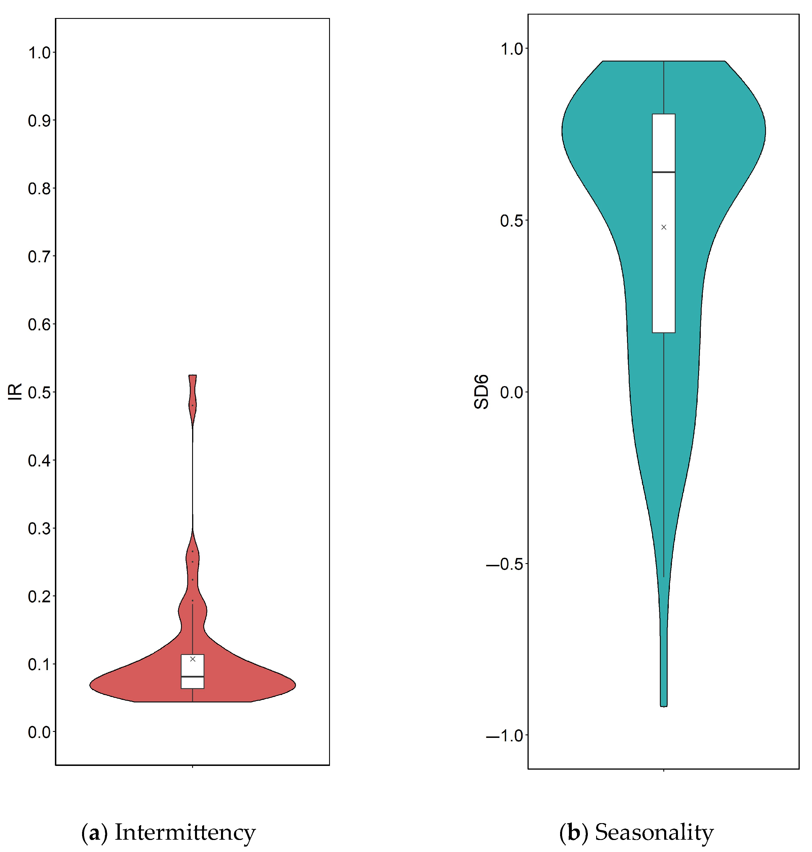
3.1.1. The Intermittency of Taiwan Rivers

The intermittency ratio (IR), defined as the proportion of low-flow days in a year, was used to indicate whether rivers consistently maintain flow. The results of this study show that the average annual IR across 65 sites in Taiwan is 0.11, corresponding to approximately 44 low-flow days per year. Although the maximum IR reached 0.52, most sites exhibited values around 0.07 (Figure 2a). Among all sites, 92% had IR < 0.2 (blue points), which were distributed throughout Taiwan (Figure 3a). These results indicate that low-flow conditions occur infrequently, showing that most rivers in Taiwan maintain flow for the majority of the year and exhibit weak intermittency.
The 6-month seasonality of dry periods (SD6) represents the timing and degree of seasonal concentration of annual low-flow events. In this study, a threshold of 0.5 was used to distinguish levels of seasonal concentration. The results show that the mean SD6 value across Taiwan is 0.48, with a peak frequency at 0.76 (Figure 2b). Sixty-two percent of stations showed strongly winter-concentrated low-flow periods (SD6 > 0.5), while 22% showed low flows in winter but with lower concentration (0 < SD6 ≤ 0.5). Fourteen percent of stations showed low-flow periods in summer with low concentration (−0.5 < SD6 ≤ 0), and 3% showed strongly summer-concentrated low-flow periods (SD6 ≤ −0.5). These findings show that most regions in Taiwan experience low-flow events that are seasonally concentrated during the 6 consecutive months of the dry season, particularly in winter. Spatial distribution maps show that sites with winter-concentrated low flows (red points in Figure 3b) are mainly located west of the Central Range. In contrast, areas east of the range and in the north exhibit lower levels of seasonal concentration (−0.5 < SD6 ≤ 0.5, light-colored points in Figure 3b). This pattern reflects Taiwan’s distinct seasonality and highlights the influence of monsoons on low-flow events.

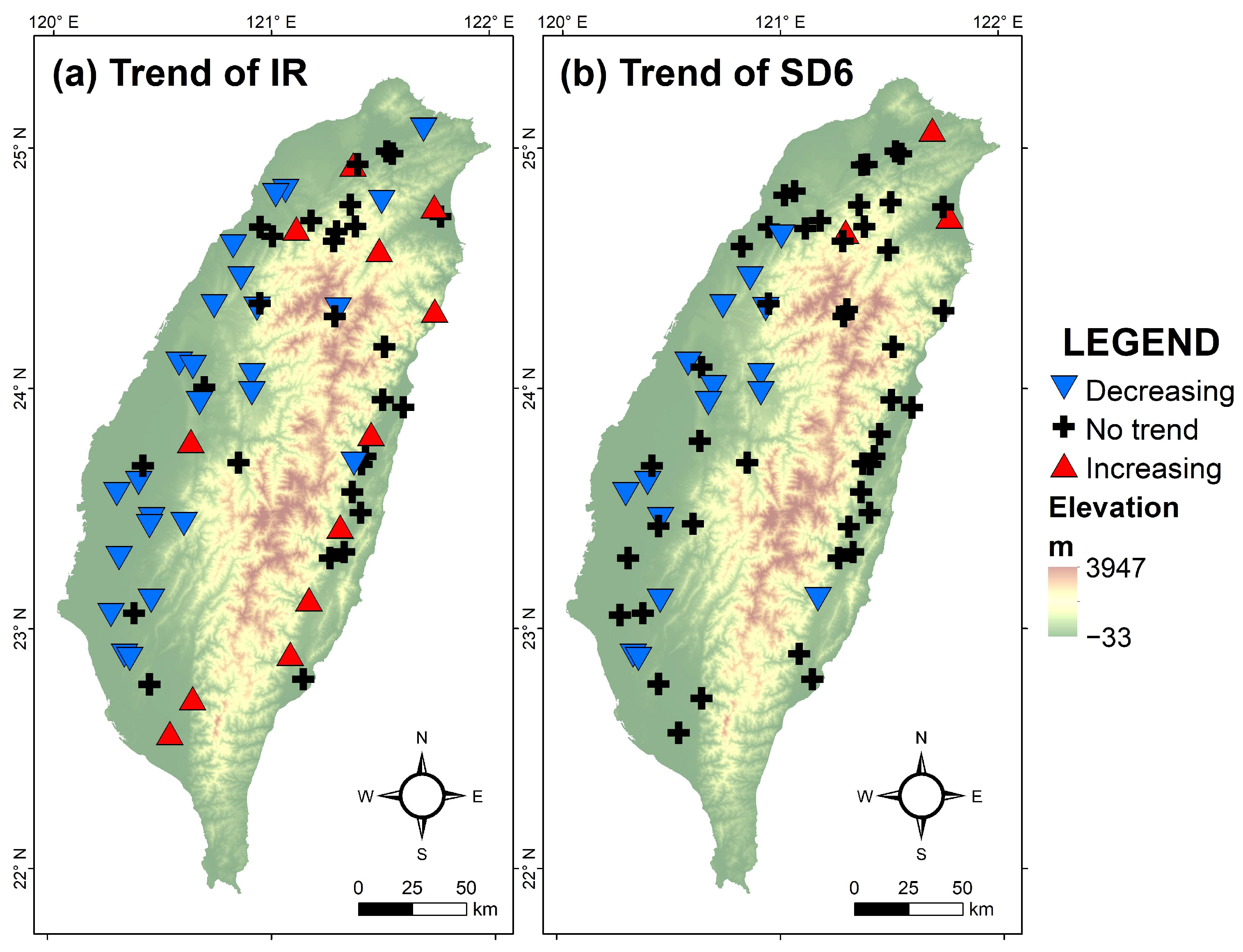
3.1.2. Trend of Hydrological Indices

This study applied the Mann-Kendall test to analyze temporal trends in hydrological indicators over time. The trend analysis results for IR and SD6 are presented in Figure 4 and Table 2. As shown in Figure 4a, 18.46% of stations exhibited a significant increasing trend in IR over time, with most of these stations located east of the Central Range. In contrast, 38.46% of stations showed a significant decreasing trend, mainly concentrated west of the Central Range. The remaining 43.08% of stations showed no significant trend in IR. These findings indicate that intermittency tends to increase over time in eastern Taiwan, while it tends to decrease in the west.
Figure 4b illustrates the trend of SD6 over time. A majority of stations, 70.77%, showed no significant trend, indicating that seasonality remains relatively stable across most of Taiwan. However, 24.62% of stations exhibited a decreasing trend in SD6, primarily located in the western region. This indicates a gradual dispersion in the seasonal concentration of low-flow events at these sites, possibly due to a reduction in low-flow days during winter or an increase in low-flow days occurring in summer, leading to a lower SD6 value. On the other hand, 4.62% of stations showed an increasing trend in SD6, indicating a growing concentration of low-flow events during the winter season at those sites.

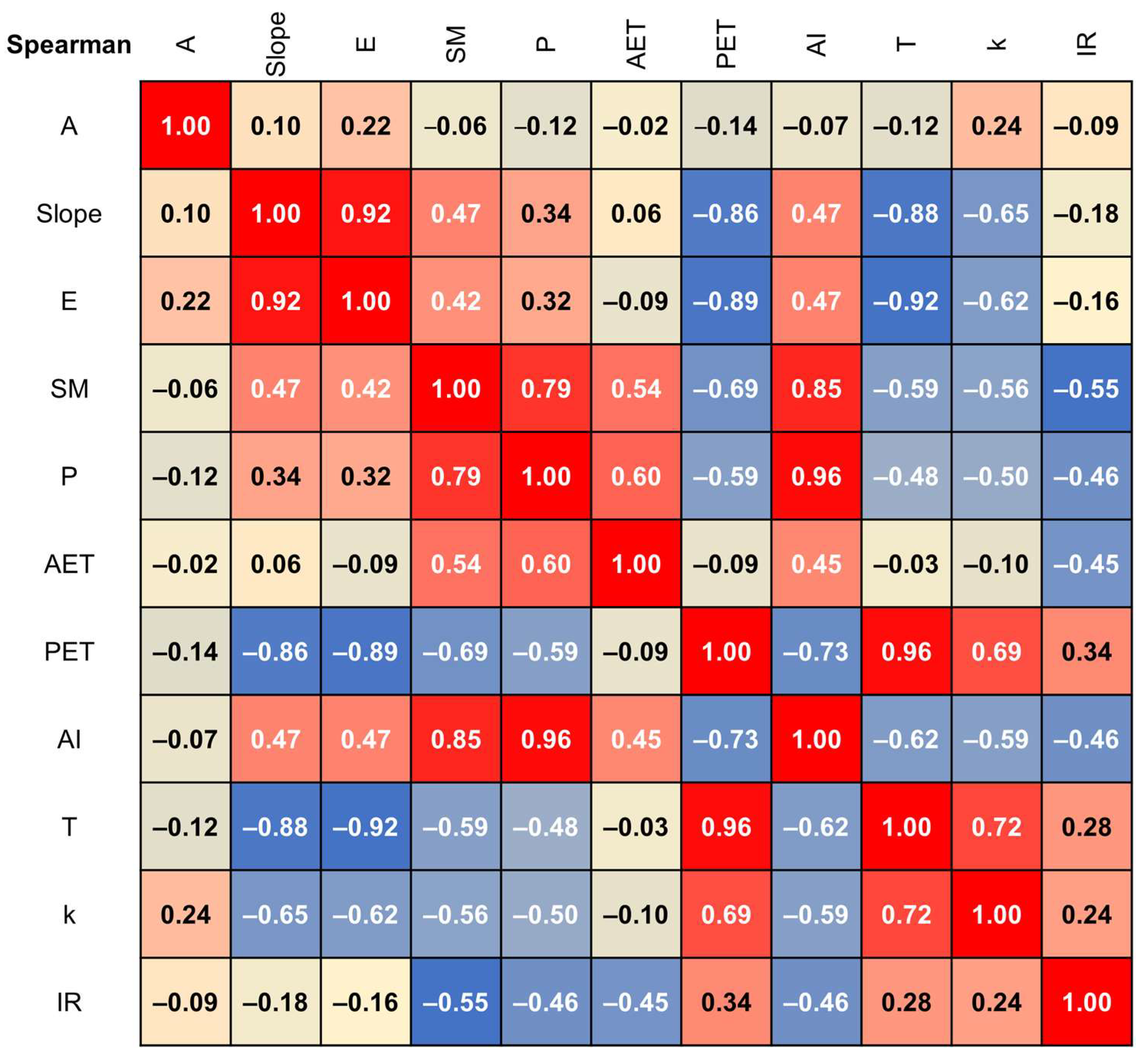
3.2. Spatial Correlation Between Catchment Attributes and Intermittency

3.2.1. Relationship Between Principal Components and Catchment Attributes

This study applied PCA to identify the catchment attributes that differentiated the upstream catchments of each station during the 6-month winter period, based on 10 catchment variables (Table 1). Since low-flow events in Taiwan predominantly occur during the winter period (with 84% of stations exhibiting SD6 > 0), this period was selected for subsequent analyses. The correlation matrix indicated strong correlations between potential evapotranspiration (PET) and temperature (T), elevation (E), and slope (Slope) (Spearman’s ρ > 0.75), as well as between soil moisture (SM) and both precipitation (P) and the aridity index (AI) (Figure 5). To avoid multicollinearity, redundant variables were excluded. Specifically, for any pair of variables with Spearman’s |ρ| > 0.75 in the correlation matrix, the variable with the smaller absolute value of Spearman’s rank correlation coefficient with IR was removed, while the variable with the larger value was retained. Five independent catchment attributes were retained for PCA: catchment area (A), soil moisture (SM), actual evapotranspiration (AET), potential evapotranspiration (PET), and permeability (k). The correlation between AET and PET during the 6-month winter period was relatively low (ρ = −0.09), primarily due to limited precipitation in winter in Taiwan, which results in an insufficient water supply and consequently lower AET.
The results of the PCA of the catchment attributes during the 6-month winter period are presented in Figure 6 and Table 3. In Figure 6, red arrows represent the catchment attributes, while blue dots indicate the 65 catchments. The loading values in Table 3 reflect the extent to which each catchment attribute contributes to the principal components, and the signs of the loading vectors indicate whether the attribute is aligned positively or negatively with the direction of the corresponding principal component. The analysis showed that the eigenvalue of the third principal component was 0.955, indicating that only the first two principal components had eigenvalues greater than 1. Together, these first two principal components accounted for 68.49% of the total variables. In the first principal component (PC1), soil moisture (SM) had a loading of −0.6, indicating that PC1 is primarily influenced by SM in the opposite direction. Permeability (k) and potential evapotranspiration (PET) also have moderate contributions to PC1, with loading values of 0.491 and 0.535, respectively. The second principal component (PC2) is mainly governed by catchment area (A), with a loading of 0.983.

3.2.2. Correlation Between Principal Components and Intermittency

The results of this study showed that intermittency was significantly positively correlated with the first principal component (PC1), while its correlation with the second principal component (PC2) was not significant (Table 4). This indicated that intermittency was strongly correlated with soil moisture (SM), moderately correlated with potential evapotranspiration (PET) and permeability (k), and showed little-to-no correlation with catchment area (A) and actual evapotranspiration (AET). Therefore, it can be inferred that regions with lower soil moisture, higher potential evapotranspiration, or greater permeability tend to exhibit higher flow intermittency.

3.3. Temporal Correlation Between Climatic Indices and Intermittency

The results show that among the 65 streamflow stations, the intermittency is statistically significantly correlated with the climatic indices of their upstream catchments at the 5% significance level. For these stations, the average Spearman’s rank correlation coefficient (ρ) is presented, with the maximum and minimum ρ values shown in parentheses (Table 5). The correlation results are summarized in Table 5 and illustrated in Figure 7 and Figure 8.

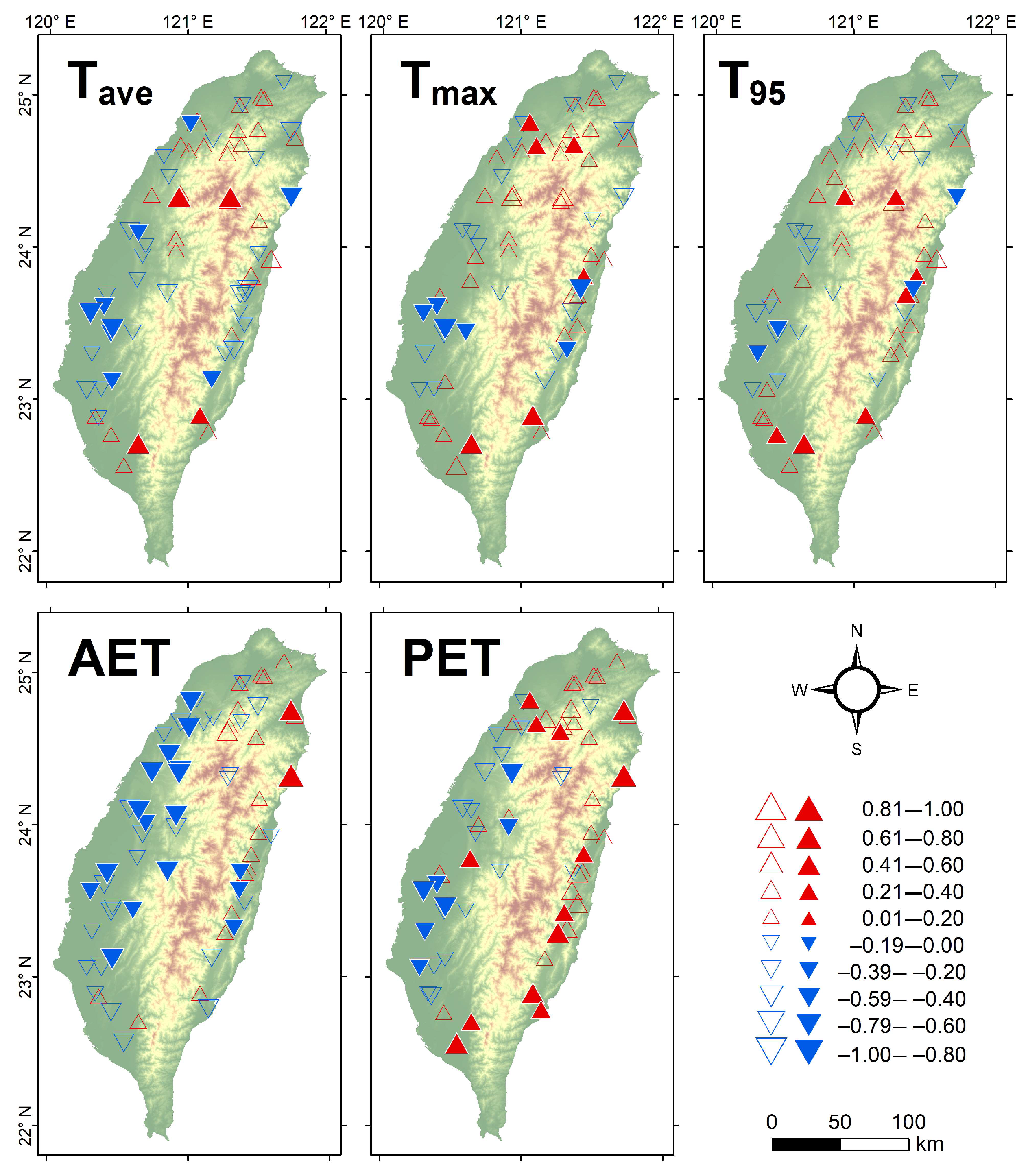
3.3.1. Temperature-Related Climatic Indices

Theoretically, Tave, Tmax, T95, AET, and PET are expected to exhibit positive correlations with intermittency. However, the results for temperature-related indices (Tave, Tmax, T95, AET, and PET) show inconsistencies with this theoretical expectation. Fewer than 50% of the stations showed statistically significant correlations with these indices, and among those stations, both significantly positive and significantly negative correlations were observed (Table 5 and Figure 7). This outcome may be attributed to the decreasing trend of intermittent overtime in Western Taiwan, which contrasts with the general trend of global warming. It may also be since the dry season in Taiwan typically occurs during the colder winter months, when evapotranspiration is relatively low. These findings indicate that evapotranspiration may not be the primary factor influencing intermittency in the western region.

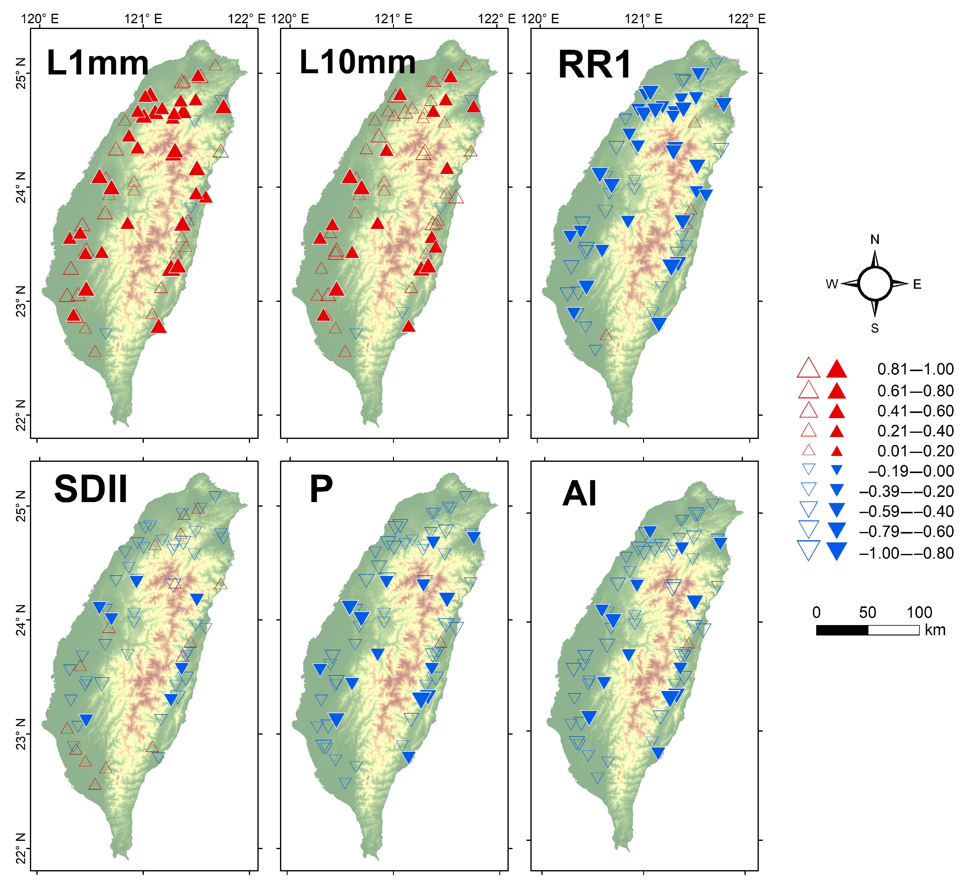
3.3.2. Precipitation-Related Climatic Indices

Theoretically, AI, RR1, SDII, and P are expected to exhibit negative correlations with intermittency, while L1mm and L10mm are expected to exhibit positive correlations. The results show that intermittency, defined as the proportion of low-flow days, is strongly correlated with L1mm (the proportion of days with less than 1 mm of rainfall per year) during the dry season. More than half of the stations (>50%) exhibit statistically significant correlations, all of which are positive and evenly distributed across the study area (Table 5 and Figure 8). This indicates that the frequency of dry days has a greater influence on intermittency than total precipitation (P) or rainfall intensity (SDII).
In addition, Spearman’s ρ for the aridity index (AI = P/PET) is more similar in magnitude and spatial pattern to those for precipitation (P) than to those for potential evapotranspiration (PET). Since Taiwan is classified as a humid region (AI > 0.65), and 57% of the catchments had more than half of the years (from 1960 to 2021) with precipitation exceeding PET (AI > 1) even during winter, these findings further indicate that during winter, rainfall has a greater influence on river intermittency in Taiwan than evapotranspiration.

4. Discussion

This study is the first to provide a detailed analysis of the spatial distribution and temporal trends of streamflow intermittency in Taiwan during the winter season. Under a climatic year framework (from November to the following October), Taiwan exhibits weak intermittency overall, with contrasting trends between the eastern and western regions [24].
The characteristics of intermittency observed in this study align with findings from other regions located in different climate zones, where soil moisture and permeability have been identified as major influencing factors [10,15]. However, the catchment area did not show a significant influence on intermittency in this study. This discrepancy may be due to the smaller study area, the limited number of upstream monitoring stations, or the interactions between catchment attributes that result in similar streamflow behaviors [12]. Furthermore, soil moisture exhibited a high correlation with precipitation and the aridity index (ρ = 0.8), indicating a strong spatial consistency among these variables. In addition, PET showed a moderate loading on PC1 (loading value = 0.535), indicating spatial variability in PET as well. These findings suggest that climatic factors across catchments in Taiwan during the dry season are not uniform and exhibit noticeable spatial heterogeneity. This is consistent with large-scale studies, which have identified climate factors, particularly the aridity index, as key drivers of intermittency variation [3,4,13]. However, since this study excluded non-independent variables through principal component analysis, the spatial influence of precipitation and the aridity index were not further examined. Future studies are recommended to incorporate these variables or to consider precipitation, the aridity index, and soil moisture as interchangeable indicators of catchment characteristics during winter in Taiwan.
Temporally, differences in streamflow intermittency trends between Eastern and Western Taiwan were mainly driven by rainfall frequency. Among all indicators, the proportion of days with rainfall less than 1 mm showed the strongest correlation, indicating that rainfall frequency strongly affects stream intermittency in Taiwan. In contrast, trends in intermittency showed weaker associations with temperature and evapotranspiration. This can be explained by the fact that low-flow events in Taiwan predominantly occur in winter [24], a period characterized by lower temperatures, which diminishes the influence of temperature-related variables. Moreover, from January to March, the northeast monsoon brings precipitation to the eastern region, while the western region receives little-to-no rainfall [42]. According to studies that link the distribution of drought severity based on SPI and changes in rainfall patterns, rainfall frequency has been increasing in Eastern Taiwan but decreasing in the west [43,44,45]. This suggests that intermittency can partially reflect drought conditions [11,14], and further analysis of the relationship between intermittency and drought indices is recommended to assess the feasibility of using intermittency as an indicator of drought severity. In addition, intermittency can be influenced by anthropogenic activities [11]. It is recommended that future studies incorporate NDVI or LULC data into the analysis and examine the distribution of LULC upstream and downstream of each station to better understand the impact of human activities on flow intermittency.
In addition, this study adopted the multi-year average of the annual minimum 7-day mean discharge (minq7) as the threshold since most stations are situated in mid-to-downstream regions where wet and dry seasons are clearly defined. From a water resource management perspective, flows below minq7 may pose a threat to aquatic habitats, underscoring its ecological relevance. It is recommended that future studies incorporate analyses of biological richness to further evaluate the ecological implications of stream intermittency. To enhance the applicability of this approach in other regions, streamflow records should ideally span at least 30 years. In cases where long-term data are unavailable, thresholds may be established using alternative indicators such as mean annual discharge, aridity index, or climate classification.

5. Conclusions

This study analyzed the intermittency (IR), seasonality (SD6), and long-term trends of hydrological indicators from 1960 to 2022 across 65 streamflow gauging stations throughout Taiwan to assess the current state of river conditions. Additionally, the relationships between winter intermittency (IR) and 10 catchment attributes were explored using principal component analysis (PCA) to identify key spatial drivers. Finally, the study examined the correlations between winter intermittency and climate indices.
  • The results of hydrological indicators showed that most rivers in Taiwan maintain flow throughout the year, indicating low intermittency, with an average of approximately 44 low-flow days per year. These rivers can be classified as perennial. Low-flow events primarily occurred during the dry season and were concentrated in winter, exhibiting strong seasonal patterns influenced by the monsoon climate. Over time, river intermittency decreased in the western regions and increased in the eastern regions, while flow variability tended to decline. Although the seasonal concentration (SD6) remained stable in most locations (71%), about 25% of the western sites showed signs of decreasing concentration.
  • The analysis of catchment attributes during the 6-month winter period revealed that variations among Taiwan’s catchments were mainly driven by soil moisture and catchment area. Among them, intermittency showed a significant negative correlation with PC1, which represents soil moisture (ρ = −0.57, p-value < 0.05), but it had little association with catchment area. This suggests that catchments with lower soil moisture, higher potential evapotranspiration, or higher permeability tend to exhibit greater intermittency in streamflow.
  • The analysis of correlations between intermittency and climate indices indicated that, compared to temperature or total precipitation, the frequency of non-rainy days (L1mm, defined as the proportion of days with rainfall less than 1 mm) had the strongest association with stream intermittency. In particular, the number of rainy days (RR1) was strongly and negatively correlated with low-flow occurrence, showing that rainfall frequency plays a dominant role in controlling low-flow conditions in Taiwan. This also implies a limited capacity for streamflow retention.
This study provides a comprehensive assessment of stream intermittency across Taiwan and proposes a clear evaluation framework for identifying the key characteristics most closely associated with winter intermittency in both spatial and temporal dimensions. In addition, the SD6 calculation formula was revised to better reflect regional seasonality. These insights can support river management and water resource planning.

Author Contributions

Conceptualization, X.F., H.-Y.C. and H.-F.Y.; methodology, X.F. and H.-F.Y.; formal analysis, X.F.; data curation, X.F. and H.-Y.C.; writing—original draft preparation, X.F.; writing—review and editing, X.F. and H.-Y.C.; supervision, H.-F.Y. All authors have read and agreed to the published version of the manuscript.

Funding

This research received no external funding

Data Availability Statement

River flow gauge stations data and daily streamflow data used in this study are accessible online at https://www.wra.gov.tw/cl.aspx?n=39575 (accessed on 1 November 2024).

Conflicts of Interest

The authors declare no conflicts of interest.

References

  1. Busch, M.H.; Costigan, K.H.; Fritz, K.M.; Datry, T.; Krabbenhoft, C.A.; Hammond, J.C.; Zimmer, M.; Olden, J.D.; Burrows, R.M.; Dodds, W.K.; et al. What’s in a Name? Patterns, Trends, and Suggestions for Defining Non-Perennial Rivers and Streams. Water 2020, 12, 1980. [Google Scholar] [CrossRef]
  2. Gómez-Gener, L.; Siebers, A.R.; Arce, M.I.; Arnon, S.; Bernal, S.; Bolpagni, R.; Datry, T.; Gionchetta, G.; Grossart, H.-P.; Mendoza-Lera, C.; et al. Towards an improved understanding of biogeochemical processes across surface-groundwater interactions in intermittent rivers and ephemeral streams. Earth-Sci. Rev. 2021, 220, 103724. [Google Scholar] [CrossRef]
  3. Sauquet, E.; Shanafield, M.; Hammond, J.C.; Sefton, C.; Leigh, C.; Datry, T. Classification and trends in intermittent river flow regimes in Australia, northwestern Europe and USA: A global perspective. J. Hydrol. 2021, 597, 126170. [Google Scholar] [CrossRef]
  4. Messager, M.L.; Lehner, B.; Cockburn, C.; Lamouroux, N.; Pella, H.; Snelder, T.; Tockner, K.; Trautmann, T.; Watt, C.; Datry, T. Global prevalence of non-perennial rivers and streams. Nature 2021, 594, 391–397. [Google Scholar] [CrossRef] [PubMed]
  5. Poff, N.L.; Ward, J. Implications of Streamflow Variability and Predictability for Lotic Community Structure: A Regional Analysis of Streamflow Patterns. Can. J. Fish. Aquat. Sci. 1989, 46, 1805–1818. [Google Scholar] [CrossRef]
  6. Uys, M.C.; O’keeffe, J.H. Simple words and fuzzy zones: Early directions for temporary river research in South Africa. Environ. Manag. 1997, 21, 517–531. [Google Scholar] [CrossRef]
  7. Reynolds, L.V.; Shafroth, P.B.; LeRoy Poff, N. Modeled intermittency risk for small streams in the Upper Colorado River Basin under climate change. J. Hydrol. 2015, 523, 768–780. [Google Scholar] [CrossRef]
  8. D’Ambrosio, E.; De Girolamo, A.M.; Barca, E.; Ielpo, P.; Rulli, M.C. Characterising the hydrological regime of an ungauged temporary river system: A case study. Environ. Sci. Pollut. Res. 2017, 24, 13950–13966. [Google Scholar] [CrossRef]
  9. Yu, S.; Bond, N.R.; Bunn, S.E.; Xu, Z.; Kennard, M.J. Quantifying spatial and temporal patterns of flow intermittency using spatially contiguous runoff data. J. Hydrol. 2018, 559, 861–872. [Google Scholar] [CrossRef]
  10. Belemtougri, A.P.; Ducharne, A.; Tazen, F.; Oudin, L.; Karambiri, H. Understanding key factors controlling the duration of river flow intermittency: Case of Burkina Faso in West Africa. J. Hydrol.-Reg. Stud. 2021, 37, 100908. [Google Scholar] [CrossRef]
  11. Yildirim, I.; Aksoy, H. Intermittency as an indicator of drought in streamflow and groundwater. Hydrol. Process. 2022, 36, e14615. [Google Scholar] [CrossRef]
  12. Jehn, F.U.; Bestian, K.; Breuer, L.; Kraft, P.; Houska, T. Using hydrological and climatic catchment clusters to explore drivers of catchment behavior. Hydrol. Earth Syst. Sci. 2020, 24, 1081–1100. [Google Scholar] [CrossRef]
  13. Oueslati, O.; De Girolamo, A.M.; Abouabdillah, A.; Kjeldsen, T.R.; Lo Porto, A. Classifying the flow regimes of Mediterranean streams using multivariate analysis. Hydrol. Process. 2015, 29, 4666–4682. [Google Scholar] [CrossRef]
  14. Tramblay, Y.; Rutkowska, A.; Sauquet, E.; Sefton, C.; Laaha, G.; Osuch, M.; Albuquerque, T.; Alves, M.H.; Banasik, K.; Beaufort, A.; et al. Trends in flow intermittence for European rivers. Hydrol. Sci. J. 2020, 66, 37–49. [Google Scholar] [CrossRef]
  15. Šarauskienė, D.; Akstinas, V.; Nazarenko, S.; Kriaučiūnienė, J.; Jurgelėnaitė, A. Impact of physico-geographical factors and climate variability on flow intermittency in the rivers of water surplus zone. Hydrol. Process. 2020, 34, 4727–4739. [Google Scholar] [CrossRef]
  16. Mimeau, L.; Künne, A.; Devers, A.; Branger, F.; Kralisch, S.; Lauvernet, C.; Vidal, J.-P.; Bonada, N.; Csabai, Z.; Mykrä, H.; et al. Projections of streamflow intermittence under climate change in European drying river networks. Hydrol. Earth Syst. Sci. 2025, 29, 1615–1636. [Google Scholar] [CrossRef]
  17. Zipper, S.C.; Hammond, J.C.; Shanafield, M.; Zimmer, M.; Datry, T.; Jones, C.N.; E Kaiser, K.; E Godsey, S.; Burrows, R.M.; Blaszczak, J.R.; et al. Pervasive changes in stream intermittency across the United States. Environ. Res. Lett. 2021, 16, 084033. [Google Scholar] [CrossRef]
  18. Datry, T.; Larned, S.T.; Tockner, K. Intermittent Rivers: A Challenge for Freshwater Ecology. Bioscience 2014, 64, 229–235. [Google Scholar] [CrossRef]
  19. Sabater, S.; Barcelo, D.; De Castro-Catala, N.; Ginebreda, A.; Kuzmanovic, M.; Petrovic, M.; Pico, Y.; Ponsati, L.; Tornes, E.; Munoz, I. Shared effects of organic microcontaminants and environmental stressors on biofilms and invertebrates in impaired rivers. Environ. Pollut. 2016, 210, 303–314. [Google Scholar] [CrossRef]
  20. Rodrigues, S.; Xavier, B.; Nogueira, S.; Antunes, S.C. Intermittent Rivers as a Challenge for Freshwater Ecosystems Quality Evaluation: A Study Case in the Ribeira de Silveirinhos, Portugal. Water 2022, 15, 17. [Google Scholar] [CrossRef]
  21. Döll, P.; Schmied, H.M. How is the impact of climate change on river flow regimes related to the impact on mean annual runoff? A global-scale analysis. Environ. Res. Lett. 2012, 7, 014037. [Google Scholar] [CrossRef]
  22. Water Resources Agency. Hydrological Year Book 2022; Water Resource Agency, Ministry of Economic Affairs: Taichung, Taiwan, 2022. [Google Scholar]
  23. Yeh, H.-F.; Chen, H.-Y. Assessing the long-term hydrologic responses of river catchments in Taiwan using a multiple-component hydrograph approach. J. Hydrol. 2022, 610, 127916. [Google Scholar] [CrossRef]
  24. Chen, H.-Y.; Fang, X.; Yeh, H.-F. Trends in Flow Intermittency, Variability, and Seasonality for Taiwan Rivers. Water 2025, 17, 271. [Google Scholar] [CrossRef]
  25. Peel, M.C.; Finlayson, B.L.; McMahon, T.A. Updated world map of the Köppen-Geiger climate classification. Hydrol. Earth Syst. Sci. 2007, 11, 1633–1644. [Google Scholar] [CrossRef]
  26. Beck, H.E.; McVicar, T.R.; Vergopolan, N.; Berg, A.; Lutsko, N.J.; Dufour, A.; Zeng, Z.; Jiang, X.; van Dijk, A.; Miralles, D.G. High-resolution (1 km) Koppen-Geiger maps for 1901–2099 based on constrained CMIP6 projections. Sci. Data 2023, 10, 724. [Google Scholar] [CrossRef]
  27. Ministry of Digital Affairs. Government Information Open Platform. Available online: https://data.gov.tw/ (accessed on 23 August 2023).
  28. Abatzoglou, J.T.; Dobrowski, S.Z.; Parks, S.A.; Hegewisch, K.C. TerraClimate, a high-resolution global dataset of monthly climate and climatic water balance from 1958–2015. Sci. Data 2018, 5, 170191. [Google Scholar] [CrossRef]
  29. TCCIP. Gridded Historical Daily Date, Taiwan Climate Change Projection Information and Adaptation Knowledge Platform. Available online: https://tccip.ncdr.nat.gov.tw/index_eng.aspx (accessed on 19 August 2024).
  30. Gleeson, T.; Smith, L.; Moosdorf, N.; Hartmann, J.; Dürr, H.H.; Manning, A.H.; van Beek, L.P.H.; Jellinek, A.M. Mapping permeability over the surface of the Earth. Geophys. Res. Lett. 2011, 38, L02401. [Google Scholar] [CrossRef]
  31. Tayer, T.C.; Beesley, L.S.; Douglas, M.M.; Bourke, S.A.; Callow, J.N.; Meredith, K.; McFarlane, D. Ecohydrological metrics derived from multispectral images to characterize surface water in an intermittent river. J. Hydrol. 2023, 617, 129087. [Google Scholar] [CrossRef]
  32. Yu, S.; Shanafield, M.; Kennard, M.J. Assessing the Influence of Zero-Flow Threshold Choice for Characterising Intermittent Stream Hydrology. Hydrol. Process. 2024, 38, e15300. [Google Scholar] [CrossRef]
  33. Gallart, F.; Prat, N.; García-Roger, E.M.; Latron, J.; Rieradevall, M.; Llorens, P.; Barberá, G.G.; Brito, D.; De Girolamo, A.M.; Lo Porto, A.; et al. A novel approach to analysing the regimes of temporary streams in relation to their controls on the composition and structure of aquatic biota. Hydrol. Earth Syst. Sci. 2012, 16, 3165–3182. [Google Scholar] [CrossRef]
  34. Kendall, M.G. Rank Correlation Methods; Nafner: New York, NY, USA, 1975. [Google Scholar]
  35. Mann, H.B. Nonparametric tests against trend. Econometrica 1945, 13, 245–259. [Google Scholar] [CrossRef]
  36. Pearson, K., LIII. On lines and planes of closest fit to systems of points in space. Lond. Edinb. Dublin Philos. Mag. J. Sci. 1901, 2, 559–572. [Google Scholar] [CrossRef]
  37. Jolliffe, I.T.; Cadima, J. Principal component analysis: A review and recent developments. Philos. Trans. R. Soc. A-Math. Phys. Eng. Sci. 2016, 374, 20150202. [Google Scholar] [CrossRef]
  38. Kinnard, C.; Bzeouich, G.; Assani, A. Impacts of summer and winter conditions on summer river low flows in low elevation, snow-affected catchments. J. Hydrol. 2022, 605, 127393. [Google Scholar] [CrossRef]
  39. Kaiser, H.F. The Application of Electronic Computers to Factor Analysis. Educ. Psychol. Meas. 1960, 20, 141–151. [Google Scholar] [CrossRef]
  40. Liang, C.P.; Lin, T.C.; Suk, H.; Wang, C.H.; Liu, C.W.; Chang, T.W.; Chen, J.S. Comprehensive assessment of the impact of land use and hydrogeological properties on the groundwater quality in Taiwan using factor and cluster analyses. Sci. Total Environ. 2022, 851, 158135. [Google Scholar] [CrossRef]
  41. Spearman, C. The Proof and Measurement of Association between Two Things. Am. J. Psychol. 1904, 15, 72–101. [Google Scholar] [CrossRef]
  42. Chou, C.-B.; Weng, M.-C.; Huang, H.-P.; Chang, Y.-C.; Chang, H.-C.; Yeh, T.-Y. Monitoring the Spring 2021 Drought Event in Taiwan Using Multiple Satellite-Based Vegetation and Water Indices. Atmosphere 2022, 13, 1374. [Google Scholar] [CrossRef]
  43. Chen, S.-T.; Kuo, C.-C.; Yu, P.-S. Historical trends and variability of meteorological droughts in Taiwan / Tendances historiques et variabilité des sécheresses météorologiques à Taiwan. Hydrol. Sci. J. 2009, 54, 430–441. [Google Scholar] [CrossRef]
  44. Shiau, J.-T.; Lin, J.-W. Clustering Quantile Regression-Based Drought Trends in Taiwan. Water Resour. Manag. 2016, 30, 1053–1069. [Google Scholar] [CrossRef]
  45. Yeh, H.-F.; Lin, X.-Y.; Huang, C.-C.; Chen, H.-Y. A Meteorological Drought Migration Model for Assessing the Spatiotemporal Paths of Drought in the Choushui River Alluvial Fan, Taiwan. Geosciences 2024, 14, 106. [Google Scholar] [CrossRef]
Figure 1. Location of 65 streamflow gauging stations in Taiwan. The numbers represent stations’ no.
Water 17 02090 g001
Figure 2. Violin plot of indices: (a) IR and (b) SD6.
Water 17 02090 g002
Figure 3. Spatial distribution of indices: (a) IR and (b) SD6.
Water 17 02090 g003
Figure 4. Trend analysis: (a) IR and (b) SD6; Significant increasing (red triangle) or decreasing (blue triangle) trends at the 0.05 significance level.
Water 17 02090 g004
Figure 5. Spearman’s rank correlation coefficients (ρ) for all catchment properties during the winter period in Taiwan. Red shades indicate positive correlations, while blue shades indicate negative correlations. Darker colors represent stronger correlations, whereas lighter colors indicate weaker correlations.
Water 17 02090 g005
Figure 6. The biplot of principal components (PCs) of catchment attributes. The blue dots are the distribution of stations on the PC axis, and the red arrows are the loading of catchment attributes in PCA space. Spearman’s rank correlation coefficients (ρ) for all catchment attributes in the winter period in Taiwan.
Water 17 02090 g006
Figure 7. Map of the temporal correlations between flow intermittency and temperature-related climatic indicators during the winter period. Spearman’s rank correlation coefficients (ρ) are represented by the size of the triangles; upward red triangles indicate positive correlations, and downward blue triangles indicate negative correlations. Solid triangles denote statistically significant correlations (p-value < 0.05), while hollow triangles denote non-significant correlations.
Water 17 02090 g007
Figure 8. Map of the temporal correlations between flow intermittency and precipitation-related climatic indicators during the winter period. Spearman’s rank correlation coefficients (ρ) are represented by the size of the triangles; upward red triangles indicate positive correlations, and downward blue triangles indicate negative correlations. Solid triangles denote statistically significant correlations (p-value < 0.05), while hollow triangles denote non-significant correlations.
Water 17 02090 g008
Table 1. Catchment attributes are derived from available data.
CategoryCatchment AttributeDescriptionUnitsData Source
TopographyACatchment area(km2)DTM [27]
SlopeCatchment average slope(°)DTM [27]
ECatchment average elevation(m)DTM [27]
SoilSMCatchment average annual soil moisture (mm)TerraClimate (1960–2022) at the resolution of 4 km × 4 km [28]
ClimatePCatchment average annual precipitation (mm)TCCIP (1960–2022) at the resolution of 5 km × 5 km [29]
AETCatchment average annual actual evapotranspiration(mm)TerraClimate (1960–2022) at the resolution of 4 km × 4 km [28]
PETCatchment average annual potential evapotranspiration(mm)TerraClimate (1960–2022) at the resolution of 4 km × 4 km [28]
AICatchment average of aridity index (P/PET)(-)-
TCatchment average annual temperature(°C)TCCIP (1960–2022) at the resolution of 5 km × 5 km [29]
LithologykCatchment average permeability(m2)Gleeson et al. [30]
Table 2. Number and percentage of stations for each of the three indices at different levels of significance.
Trend DirectionSignificance LevelIRSD6
Number of
Stations
Percent of TotalNumber of
Stations
Percent of Total
Increasingp-value ≤ 0.05 *1218.46%34.62%
No trendp-value > 0.052843.08%4670.77%
Decreasingp-value ≤ 0.05 *2538.46%1624.62%
Note: * The trend is significant.
Table 3. Loading of the catchment attributes to the two statistically significant components for all streams.
LoadingPC1PC2
A 0.0130.983
k0.491−0.021
AET−0.335−0.096
PET0.535−0.140
SM −0.600−0.068
Eigenvalues2.4141.010
Variability (%)48.29%20.21%
Total variance explained (%)48.29%68.49%
Table 4. Spatial correlation between intermittent IR (11-4) and principal components for 6 months of winter period.
PCsSpearman ρp-Value
PC10.57<0.05
PC20.030.813
Table 5. Percentage of stations with statistically significant correlations (p-value < 0.05) between flow intermittency and climatic indicators. Bold values indicate the percentage of stations > 50%. The correlation coefficients (ρ) show the mean [maximum and minimum] values.
Climatic IndicatorSignificance
Stations (%)
Ρ
AVG [Max, Min]
Nonsignificant
Stations (%)
Ρ
AVG [Max, Min]
TemperatureTave20.00%−0.14 [0.49, −0.50]80.00%−0.02 [0.23, −0.28]
Tmax18.46%0.01 [0.53, −0.46]81.54%0.03 [0.25, −0.27]
T9516.92%0.12 [0.42, −0.35]83.08%0.02 [0.24, −0.25]
AET29.23%−0.32 [0.66, −0.54]70.77%−0.05 [0.24, −0.28]
PET30.77%0.10 [0.68, −0.53]69.23%0.04 [0.27, −0.23]
PrecipitationL1mm50.77%0.40 [0.64, 0.26]49.23%0.15 [0.32, −0.11]
L10mm30.77%0.35 [0.51, 0.26]69.23%0.14 [0.31, −0.06]
RR149.23%−0.40 [−0.26, −0.64]50.77%−0.15 [0.11, −0.32]
SDII10.77%−0.34 [−0.29, −0.39]89.23%−0.05 [0.19, −0.27]
AI21.54%−0.39 [−0.28, −0.65]78.46%−0.16 [0.01, −0.28]
Disclaimer/Publisher’s Note: The statements, opinions and data contained in all publications are solely those of the individual author(s) and contributor(s) and not of MDPI and/or the editor(s). MDPI and/or the editor(s) disclaim responsibility for any injury to people or property resulting from any ideas, methods, instructions or products referred to in the content.

