Article

Uncovering Anthropogenic Changes in Small- and Medium-Sized River Basins of the Southwestern Caspian Sea Watershed: Global Information System and Remote Sensing Analysis Using Satellite Imagery and Geodatabases

by
Vladimir Tabunshchik
1,2,*,
Aleksandra Nikiforova
1,2,
Nastasia Lineva
1,2,
Roman Gorbunov
1,2,
Tatiana Gorbunova
1,2,
Ibragim Kerimov
2,
Abouzar Nasiri
3 and
Cam Nhung Pham
1,2
1
A.O. Kovalevsky Institute of Biology of the Southern Seas of RAS, 299011 Sevastopol, Russia
2
Department of Ecology and Environmental Management, Millionshchikov Grozny State Oil Technical University, 364024 Grozny, Russia
3
Firouzabad Higher Education Center, Shiraz University of Technology, Shiraz 71557-13876, Iran
*
Author to whom correspondence should be addressed.
Water 2025, 17(13), 2031; https://doi.org/10.3390/w17132031
Submission received: 20 May 2025 / Revised: 26 June 2025 / Accepted: 2 July 2025 / Published: 6 July 2025
(This article belongs to the Special Issue Applications of Remote Sensing and GISs in River Basin Ecosystems)

Abstract

This study investigates the anthropogenic transformation of small- and medium-sized river basins within the Caspian Sea catchment. The basins of seven rivers—Sunzha, Sulak, Ulluchay, Karachay, Atachay, Haraz, and Gorgan—were selected as key study areas. For both the broader Caspian region, particularly its southwestern sector, and the selected study sites, trends in land cover types were analyzed, natural resource use practices were assessed, and population density dynamics were examined. Furthermore, a range of indices were calculated to quantify the degree of anthropogenic transformation, including the coefficient of anthropogenic transformation, the land degradation index, the urbanity index, the degree of anthropogenic transformation, coefficients of absolute and relative tension of the ecological and economic balance, and the natural protection coefficient. The study was conducted using geoinformation research methods and sets of geodata databases—the global LandScan population density database, the GHS Population Grid database, the ESRI land cover type dynamics database, and OpenStreetMap (OSM) data. The analysis was performed using the geoinformation programs QGIS and ArcGIS, and a large amount of literary and statistical data was additionally analyzed. It is shown that within the studied region, there has been a decrease in the number and density of the population, as a result of which the territories of river basins are experiencing an increasing anthropogenic impact, the woody type of land cover is decreasing, and the agricultural type is increasing. The most anthropogenically transformed river basins are Karachay, Haraz, and Gorgan.

1. Introduction

Contemporary society increasingly values scientific fields that contribute to practical solutions in areas like natural resource management, sustainable resource utilization, landscape planning, environmental impact assessment, monitoring, forecasting, and conservation. Addressing these challenges requires a thorough evaluation of landscapes’ natural capacity, current condition, degree of anthropogenic alteration, and overall vulnerability [1]. A comprehensive spatial and temporal analysis of human-induced impacts on landscapes is especially critical given expanding economic activities [2,3]. These impacts can create conditions detrimental to human health [4], particularly in regions with substantial industrial development.
Dynamic shifts in nature management practices across the globe are becoming a key area of focus for researchers and are a high priority in global sustainability studies [5]. In recent years, rapid economic growth and evolving business practices, especially in developing countries, have led to significant changes in how nature is managed worldwide, directly impacting terrestrial ecosystems [6]. Nature management, in its broadest sense, is now seen as a primary driver of environmental change from the local to the global scale and is increasingly included in environmental assessments [7,8]. Various environmental components are actively altered through nature management. Soil quality is a crucial natural indicator of ecosystem function, supporting ecological biodiversity and the health of plants and animals [9]. Notably, soil quality tends to decline when natural landscapes are converted into human-managed landscapes and ecosystems [2,10].
Studying nature management practices and changes in soil cover helps us understand the processes behind deforestation, degradation, erosion, desertification, and the loss of biodiversity [11]. For instance, ref. [10] demonstrated that, under different nature management approaches, key indicators of soil quality—such as organic matter, total nitrogen, bulk density, porosity, cation exchange capacity, and exchangeable calcium and magnesium—were significantly lower compared to undisturbed forest soils. Sustainable land management practices are essential to improving soil quality in various land-use systems, especially in tropical and sub-humid ecosystems [10]. A study by [12] showed that agricultural soils differ from those managed for other purposes in terms of nutrient and heavy metal concentrations, as well as the abundance of microorganisms involved in the nitrogen cycle.
Remote sensing methods are now widely used to acquire data on the Earth’s surface, offering greater efficiency compared to traditional field surveys. Monitoring land cover change commonly involves employing remote sensing technologies, geographic information systems (GIS), and other spatial analysis tools to analyze satellite imagery, aerial photography, and other data sources. These methods enable researchers to identify and quantify changes over time, evaluate the drivers of these changes, and predict future trends.
Changes in Earth’s land cover are increasingly recognized as a prominent indicator of environmental change across space and time [13,14]. It is well established that human activities have significantly affected the natural environment [15]; humans have altered approximately three-quarters of the Earth’s surface over the last thousand years [16]. Land cover change is a common consequence of human activity [17,18], and research [19] identifies this process as one of the nine “planetary boundaries” (indicators that signal humanity’s approach to global environmental changes that threaten its well-being). Monitoring these changes is a crucial component of developing effective natural resource management strategies and analyzing environmental shifts [18,20,21,22]. Gaining insight into past, present, and future land cover changes is essential for informed watershed management [23]. Land cover changes within a river basin are influenced by factors such as elevation, slope, distance from the river, soil erosion, and proximity to major roads and settlements [24]. Primarily, these changes are driven by human activities, including urbanization, industrialization, and agricultural development. This, in turn, can affect water resource availability and significantly modify the volume and patterns of water runoff [25].
Numerous studies have explored land cover changes using remote sensing and geoinformatics [15,16,17,18,19,26,27,28]. For instance, in [19], the authors employed a hybrid spectral image recognition technique to identify eight spatiotemporal vegetation dynamics categories in the Abbay River basin from 1994 to 2056. A 64-year study (1967–2021) [18] utilized remote sensing and GIS to analyze the spatial patterns of land cover change in the Kiliar River basin. The land cover of the Amazon River basin and its sub-basins was analyzed for the period 2001–2021 [27]. Researchers [28] developed a model of land use and land cover change in the Ergene River basin of western Turkey between 1990 and 2012, using CORINE land data and ArcGIS software. Analyzing the dynamics of land cover types, in conjunction with satellite image interpretation, can be valuable for assessing anthropogenic transformation within various operational–territorial units, including river basins [2,29]. It is worth noting that the application of GIS tools in Russian land cover studies remains limited [30,31]. For instance, V. V. Elsakova et al. investigated land cover characteristics in the Kozhim River basin (Subpolar Urals) [32]. K. V. Krasnoshchekov et al. studied land and soil cover in industrially disturbed areas of Central Siberia, assessing the extent of disturbed ecosystems and monitoring their status across four river basins [33]. Tsarev Yu. V. et al. examined statistics on vegetation cover changes in the Volga River basin [34]. Tabunshchik V. A. and Gorbunov R. V. studied the dynamics of land cover types in the river basins of the northwestern slope of the Crimean Mountains [35].
Following the collapse of the Soviet Union in 1991, the Caucasus region experienced profound institutional and political transformations as the shift from a planned to a market economy reshaped institutions and spurred land reforms [36]. Caucasus countries implemented diverse land reforms concerning land ownership, impacting primarily agriculture and forestry [37]. The Russian Federation largely distributed agricultural land to individuals via land shares, though these shares were often leased back to large corporate farms, thus limiting land ownership fragmentation. In Georgia, Armenia, and Azerbaijan, collective farms were privatized, and land was distributed among new owners, leading to significant fragmentation of both ownership and land use, with average plot sizes under 2.8 ha [36,38,39]. Forests, also state-owned and strictly managed under the Soviet Forest Code since the 1950s [40], remained under state ownership and management in the Caucasus after the collapse [40]. However, varying environmental enforcement and armed conflicts in the region raise questions about post-dissolution changes in land cover, particularly arable land and forests.
In environmental science, anthropogenic transformation encompasses the changes to the Earth’s atmosphere, biosphere, hydrosphere, lithosphere, and pedosphere resulting from human activity [40,41]. Outside of environmental science, the term is frequently employed by evolutionary biologists to refer to human origins. From a practical standpoint, it is crucial to identify not only the extent of anthropogenic landscape transformation but also the trends that may emerge in landscapes under varying anthropogenic pressures [1]. This understanding is an essential prerequisite for landscape forecasting and recommendations, and for developing future strategies. Furthermore, all possible measures must be taken to prevent adverse anthropogenic landscape changes. This underscores the importance of investigating this topic. Driven by socio-economic development and climate change, water scarcity has become a global threat, hindering progress towards landscape sustainability and the United Nations (UN) Sustainable Development Goals (SDGs) [41]. In response to this challenge, and to address the increasing demand for water in agriculture in water-scarce countries, scientists are conducting a range of comprehensive investigations focused on assessing, maintaining, optimizing, and conserving available renewable water resources [30].
From a practical perspective, understanding the scale and trends of anthropogenic transformation in the basins of small- and medium-sized rivers is crucial for effective landscape forecasting and developing sustainable management strategies. However, these basins face significant challenges, including soil degradation, loss of biological and landscape diversity, altered water runoff patterns, and increased vulnerability to climate change due to intensified human activities such as agriculture, urbanization, and industrialization. This pressure threatens ecosystem functionality and the achievement of the United Nations Sustainable Development Goals (SDGs), particularly in water-scarce regions like the Caspian Sea basin. This study presents an innovative approach to addressing these challenges by leveraging advanced remote sensing and GIS technologies to analyze land use and quantify anthropogenic impacts in the Sunzha, Sulak, Ulluchay, Karachay, Atachay, Kharaz, and Gorgan River basins. Its innovative aspects include focusing on understudied Caspian Sea basins, quantifying anthropogenic impacts, and supporting sustainable management based on integrated remote sensing and GIS analysis. This study aims to analyze nature management, examine territory surface data using remote sensing methods, and quantify the anthropogenic transformation of the following Caspian Sea river basins: Sunzha, Sulak, Ulluchay, Karachay, Atachay, Haraz, and Gorgan.

2. Materials and Methods

2.1. Study Area

The research focuses on the southwestern part of the Caspian Sea drainage basin (Figure 1).
The study area comprises seven key sites located within the southwestern Caspian Sea catchment: the Sunzha, Sulak, Ulluchay, Karachay, Atachay, Haraz, and Gorgan River catchments. These river catchment boundaries were delineated using 30-m resolution SRTM and Copernicus Digital Elevation Models (DEMs), based on the approach described by [42].

2.2. Materials

2.2.1. Population Data

Population data were sourced from the GHS Population Grid [43,44,45], a high-resolution cartographic database depicting the spatial distribution of the global population. Developed by the European Commission’s Joint Research Centre (JRC) as part of an open data initiative, the GHS Population Grid integrates satellite imagery, national censuses, and geospatial data to ensure accuracy and consistency. Its ability to provide population data at resolutions ranging from 100 m to 1 km makes it ideal for analyzing population dynamics at both global and local scales. Covering the entire Earth’s surface from 1975 onward, the GHS Population Grid enables the study of population distribution, urbanization impacts, and future trends. The open accessibility of the GHS Population Grid encourages its widespread use in scientific research and practical applications, making it a valuable tool for diverse disciplines. Data were downloaded from the official website and subsequently visualized and analyzed using ArcGIS 10.8 (Environmental Systems Research Institute (ESRI), Inc.).

2.2.2. Population Density

Population density was estimated using data from the LandScan global database [46,47]. Developed by the Oak Ridge National Laboratory (ORNL), the LandScan database [46,47] provides open access, high-resolution population density data from 2000 onward. As B.I. Kochurov [48] pointed out that analyzing land-use structure and dynamics alongside population density provides a preliminary assessment of ecologically hazardous changes resulting from the anthropogenization of natural landscapes. Data were downloaded from the official website and subsequently visualized and analyzed in ArcGIS.

2.2.3. Nature Management and Land Cover

Nature management was analyzed by interpreting high-resolution Sentinel-2 satellite imagery and integrating open statistical and spatial data, including OpenStreetMap (OSM) [49] and ESRI Land Cover [50] and datasets. Based on these nature management data, we calculated various indicators of anthropogenic transformation for the study area. We downloaded the data from official websites and processed them for visualization and analysis using ArcGIS.
Land cover data, consisting of raster images spanning from 2017 to 2023, were sourced from the ESRI Land Cover database. We selected this database primarily because of its high spatial resolution compared to similar datasets. Raster images were downloaded from the official ESRI Land Cover database website [50] and subsequently visualized and analyzed using ArcGIS.
The data used in the study are presented in Table 1.

2.3. Methods

Cartographic, historical, comparative–geographic, field observation, and geographic zoning are common methods for determining the extent of anthropogenic transformation in natural territorial complexes. However, geoinformation and remote sensing methods are of particular significance [51]. This study uses cutting-edge research methods, with a strong emphasis on geoinformation techniques. We utilized the ArcGIS 10.8 software package to load and process data related to nature management types, population density, and anthropogenic transformation for the southwestern Caspian Sea catchment.
The methodology for calculating anthropogenic transformation is based on the works of [52,53]. Using QGIS 3.16 and ArcGIS 10.8, we calculated the anthropogenic transformation of the river basin territories based on the following indicators: the coefficient of anthropogenic transformation, the land degradation index, the urbanity index, the degree of anthropogenic transformation, coefficients of the absolute tension of the ecological and economic balance, coefficients of the relative tension of the ecological and economic balance, and the coefficient of natural protection. These indicators are used to show the transformation of the landscape, and as such, the calculated values of the coefficient of anthropogenic transformation range from 0 to 10, representing a gradient from the least to the most transformed landscapes [53]. This index has been used in a large number of studies [51,52]. The land degradation index, also referred to as the index of anthropogenic alteration of lands, is employed to assess human-induced changes in landscapes. It utilizes modern technologies and methods to promote rational land use for maximum economic and social benefit. The degree of anthropogenic transformation is used to analyze the structural and functional characteristics of natural (or “restored”) landscapes, and also to analyze their anthropogenic transformation [51], aiding in the creation of zoning maps [54], among other applications.
B.I. Kochurov [49] developed a methodology for the comprehensive assessment of a territory’s ecological–economic state. The analysis of the ecological–economic state using the coefficient of absolute tension helps to balance significant anthropogenic impacts with landscape restoration potential, though spatial differences in this coefficient may not be particularly pronounced. The coefficient of relative tension provides a more precise analysis of the ecological–economic state than the absolute tension coefficient because it integrates intermediate indices of anthropogenic load. The coefficient of natural protection is used to evaluate the stability of a territory under low anthropogenic loads [55]. Therefore, given the increasing and spatially varying external pressures on the environment, studying the impact of anthropogenic influence on landscapes is of critical importance [52].
The calculation of the anthropogenic transformation of the river basins was performed using the ArcGIS 10 software package using the following indicators:
1. Coefficient of anthropogenic transformation [52]:
K = r i p i q n 100
where
K is the coefficient of anthropogenic transformation.
r i —rank of anthropogenic transformation by type of use (protected areas—1; forests—2; swamps and wetlands—3; meadows—4; gardens and vineyards—5; arable land—6; rural development—7; urban development—8; reservoirs, canals—9; land used for industrial purposes—10).
p i —rank area (%).
q —index of the depth of transformation (protected areas—1; forests—1.05; swamps, floodplains, wetlands—1.1; meadows—1.15; gardens, vineyards—1.2; arable land—1.25; rural development—1.3; urban development—1.35; reservoirs—1.4; industrial land—1.5).
n —number of divisions within the study region.
2. Land degradation index [52]:
L D I = i = 1 i = m N i S i S s c a n
S i is the area of the type of land use, km2, %.
N i —rank, or landscape disturbance index (1—forest areas and tree and shrub plantations; 2—under water and swamps; 3—pastures; 4—arable land (including irrigated); 5—industrial–transport and residential areas).
S s c a n —scanning area.
i —serial number of the type of disturbance.
m —number of types of disturbance.
3. Urbanity index [52]:
U r b a n i t y = log 10 ( U + A ) ( F + W + B )
where
U—denotes urban area;
A—agricultural area (cropland, agriculturally used grasslands);
F—forest areas;
W—water and wetland areas;
B—natural or semi-natural biotopes («natural areas»).
4. Degree of anthropogenic transformation [52]:
L a n t r o p o = S A 1 k 1 + S A 2 k 2 + + S A n k n S N T C
where
SA—area of the modified section of the natural–territorial complex.
k—numerical coefficient of the degree of anthropogenic transformation (1—protected areas, undisturbed natural areas; 2—hayfields; 3—grazing, fallow land; 4—cultivated land, arable land, rice paddies; 5—cottages and similar lands; 6—quarries, artificial ponds and water bodies, roads, cemeteries; 7—building development; 8—rural development and adjacent territories; 9—urban development and adjacent territories, industrial-type zones).
S N T C —area of the natural–territorial complex.
5. The coefficients of absolute and relative tension of the ecological and economic balance of the territory [49]:
K a = P 6 P 1
K o = P 6 + P 5 + P 4 P 1 + P 2 + P 3
where
K a —coefficients of absolute tension of the ecological and economic balance of the territory;
K o —coefficients of relative tension of the ecological and economic balance of the territory;
P 6 —industrial, transport, communications, defense and other disturbed lands, landfills, dumps;
P 5 —urban settlements;
P 4 —arable land, rural settlements;
P 3 —perennial plantations, pastures, recreational lands, forest lands;
P 2 —hayfields, fallow lands, forested lands not used for logging, reserve lands;
P 1 —protected areas, water fund lands, and other conditionally unused lands.
6. The total area of lands with environment-stabilizing and resource-stabilizing functions [49]
P r s = P 1 + 0.8 P 2 + 0.6 P 3 + 0.4 P 4
7. The coefficient of natural protection [49]:
К n p = P r s P 0
where
P r s —total area of lands with environment-stabilizing and resource-stabilizing functions;
P 0 —total area of the studied territory.
Figure 2 illustrates the overall research scheme and the formulas used for calculating anthropogenic transformation indicators.
The collected data on population size, population density, land cover type dynamics, and land use were uploaded into a GIS and visualized using standard methods described in studies [43,44,45,46,52]. Subsequently, geographic maps were created. The data on the boundaries of the river basins under study were obtained from work [42].

3. Results

3.1. Nature Management

3.1.1. General Overview of Nature Management in the Caspian Region (Russia, Azerbaijan, and Iran)

Nature Management in the Russian Federation (Republic of Dagestan and Chechen Republic)
(1)
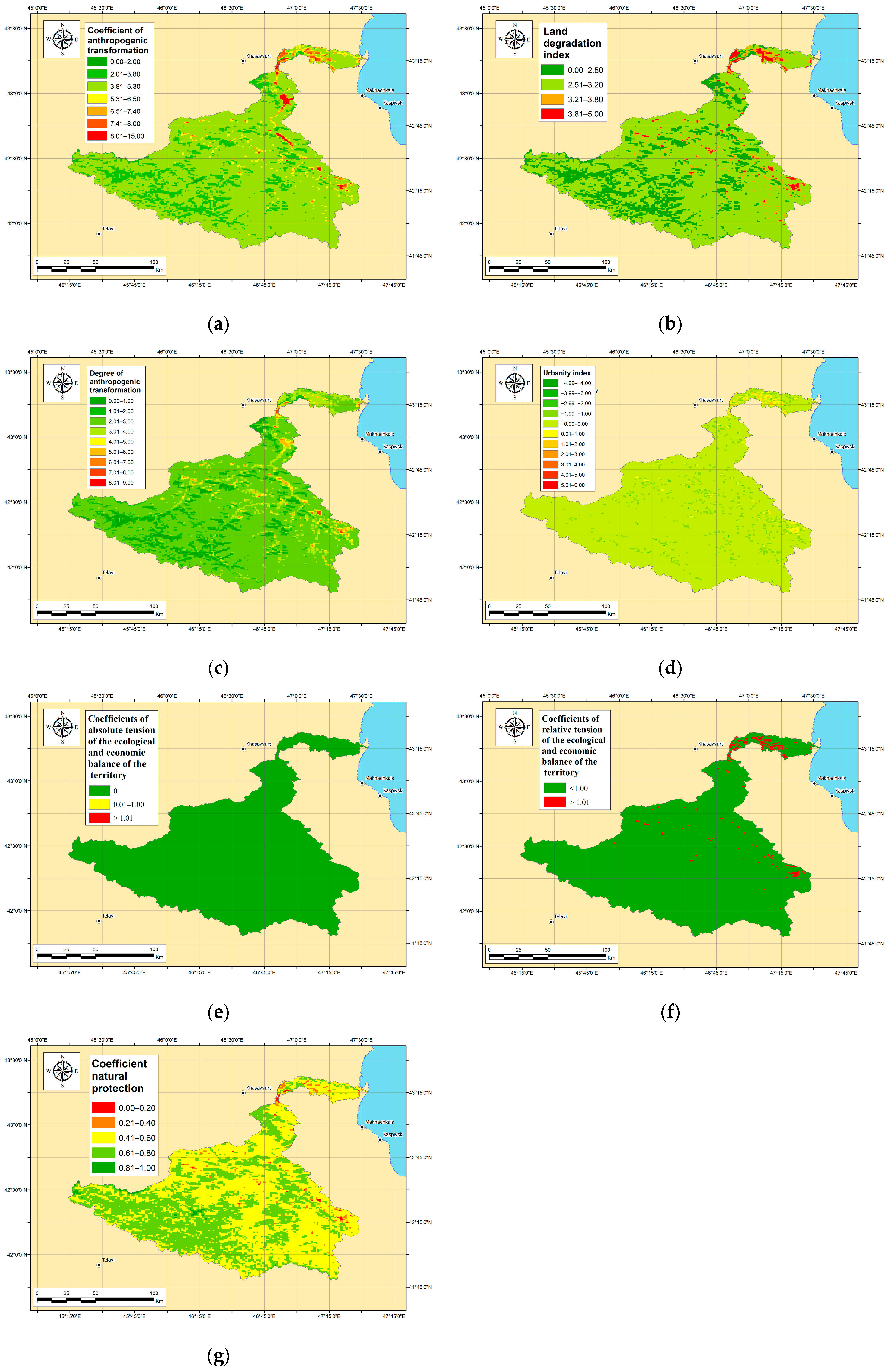
Nature Management in the Republic of Dagestan
The Republic of Dagestan’s forest fund covers 527.9 thousand hectares, representing 10.5% of its total area. Within this fund, 449.1 thousand hectares (85.0%) are forests. 364 thousand hectares are currently forested and 78.8 thousand hectares (15.0%) formerly belonging to agriculture have no management materials. The area with forest cover is 365.1 thousand hectares. Forested areas represent 7.3% of the Republic, but forest cover varies depending on location with less forests in the semi-desert and highland subalpine transition zones. Importantly, all forests within the Republic of Dagestan have protected status and are considered valuable [56], which aids in the conservation of forests outside the protected areas.
The Republic of Dagestan has established an extensive network of protected areas (PAs). There are 50 PAs of regional and local importance, covering 397,045.05 hectares, alongside five federally managed sites totaling 191,774 hectares. These include the Dagestansky Reserve (19,061 ha), the Samursky National Park (48,273 ha), the Agrakhansky Federal Sanctuary (39,000 ha), the Samursky Federal Sanctuary (1940 ha), and the Tlyaratinsky Federal Sanctuary (83,500 ha). Overall, protected areas account for 11.7% of the Republic of Dagestan’s territory [56].
The industrial potential of Dagestan’s mineral resource base remains largely untapped, except for oil, gas, and construction materials. Ore resource development is currently non-existent. The primary mineral resources extracted from Dagestan’s subsoil include oil, gas, groundwater (fresh, mineral, and thermal), seashells (for animal and poultry feed), and construction materials (limestone for sawing and facing, brick clays, sands, rubble, and sand–gravel mixtures). The main companies exploiting these resources are JSC “NK “Rosneft”-Dagneft” and JSC “Dagneftegaz” [56].
Industrial production primarily consists of manufacturing from the machine-building sector and light industry. The current breakdown is as follows: food and beverage production (over 53%); non-metallic mineral product manufacturing (over 14%); machinery and equipment manufacturing (excluding otherwise classified items) and the production of other vehicles and equipment (9.5%); computer, electronic, and optical product and electrical equipment manufacturing (7%); furniture and other finished goods production (over 6%); coke, refined petroleum product, rubber and plastic product manufacturing (3.7%); machinery and equipment repair and installation (1.9%); metallurgical and finished metal product manufacturing (excluding machinery and equipment) (1.6%); and textile, clothing, and leather production (1.3%).
The territorial organization of Dagestan’s sectoral economy is characterized by a high concentration of industry in the Central and Northern zones, which are the most developed and urbanized areas, and a lower concentration in the Southern zone. Industry remains relatively underdeveloped in the mountainous regions of Dagestan, despite significant potential for energy development (including renewable sources) and the food industry, which has been largely unexploited for decades.
Situated at the crossroads of international transportation routes, the Republic of Dagestan links “North-South” and “East-West” transport flows. Consequently, Dagestan is one of the few regions in the Russian Federation with developed infrastructure for nearly all modes of transport: rail, road, sea, air, and pipeline, including transport hubs and a network of intermodal and multimodal transport and logistics complexes. Dagestan’s density of paved public roads of federal, regional, intermunicipal, and local significance is 6.6 times higher than the Russian average [57].
Agricultural land accounts for 86.4% (4344.5 thousand hectares) of the land use in the Republic of Dagestan. Agriculture also significantly contributes to the economy, representing over 15% of the Gross Regional Product (GRP), which is nearly four times the national average for Russia. Dagestan’s specialization in agriculture is evident within the interregional division of labor in the North Caucasian Federal District (NCFD), with certain agricultural sectors exhibiting specialization levels comparable to those seen nationwide.
Agriculture is dispersed throughout the Republic of Dagestan, but the majority of agricultural production is concentrated in the mountainous (including the lowland “kutan” farms of the mountainous zone) and central zones. The region’s primary agricultural specialization within the Russian Federation is animal husbandry, encompassing cattle (including cows), small livestock (sheep and goats), and poultry breeding, with the production of staple foods such as meat, milk, and eggs. Transhumance, or distant pasture animal husbandry, plays a significant role in this sector, influencing land organization in both mountainous and lowland areas. Crop production and related food products are also significant in Dagestan’s agricultural sector, including grains, industrial crops, fruits and berries, grapes, vegetables, melons, and potatoes. Notably, Dagestan’s agricultural production, particularly in crop cultivation, is characterized by small-scale farming. Households produce over 85% of this sector’s output, with particularly high percentages for potatoes, vegetables, and fruits (96–99%). This is further supported by comparing the production of key agricultural products among households in Dagestan, neighboring regions, and across the Russian Federation.
Over 100,000 hectares of arable land, a particularly scarce resource (Dagestan has five times less arable land per capita than the Russian average), remain unused for agriculture. This is primarily due to unresolved land-use issues and the outdated technical and technological infrastructure of the agricultural sector [57].
Settlement lands in the Republic of Dagestan comprise 3.2% (160.5 thousand hectares) of the total land area. Residential land use is particularly prominent in the central part of Dagestan. This area includes the city districts of Makhachkala (the capital), Buynaksk, Izberbash, Kaspiysk, Kizilyurt, and Khasavyurt, as well as the municipal districts of Babayurtovsky, Buynaksky, Kazbekovsky, Karabudakhkentsky, Kayakentsky, Kumtorkalinsky, Kizilyurtovsky, Novolaksky, and Khasavyurtovsky. These areas are home to 57.8% of the Republic of Dagestan’s population. Central Dagestan functions as a major, multifaceted territorial zone within the Republic of Dagestan, characterized by developed industry, agro-industry, transport and logistics, a construction base, a tourism and recreation complex, and a business, scientific, and educational center. Southern Dagestan, with a population share of 19.5%, encompasses the city districts of Derbent and Dagestansky Ogni, as well as the following municipal districts: Agulsky, Dakhadaevsky, Derbentsky, Kaytagsky, Kurakhsky, Suleyman-Stalsky, Tabasaransky, Khivsky, Rutulsky, Akhtynsky, Dokuzparinsky, and Magaramkentsky. Key functions in Southern Dagestan include industry, agro-industry, tourism, recreation, and military/border-related activities. Northern Dagestan accounts for an even smaller portion of the population (7.7%) and comprises the city districts of Kizlyar and Yuzhno-Sukhokumsk and the municipal districts of Nogaysky, Kizlyarsky, Tarumovsky, and Babayurtovsky. This zone is primarily agro-industrial, although it also possesses developed industrial functions and hosts facilities of the defense–industrial complex. The main portion of mountainous Dagestan encompasses the municipal districts of Akhvakhsky, Botlikhsky, Gumbetovsky, Gergebilsky, Untsukulsky, Tlyaratinsky, Khunzakhsky, Shamilsky, Tsumadinsky, Tsuninsky, and the Bezhtinsky section, forming the “Untsukul Economic Zone” in the west. Additionally, it includes the Akushinsky, Gunibsky, Kulinsky, Laksky, Levashinsky, and Sergokalinsky districts. This mountainous area accounts for 16.6% of the population but remains largely underdeveloped economically [57].
(2)
Nature Management in the Chechen Republic
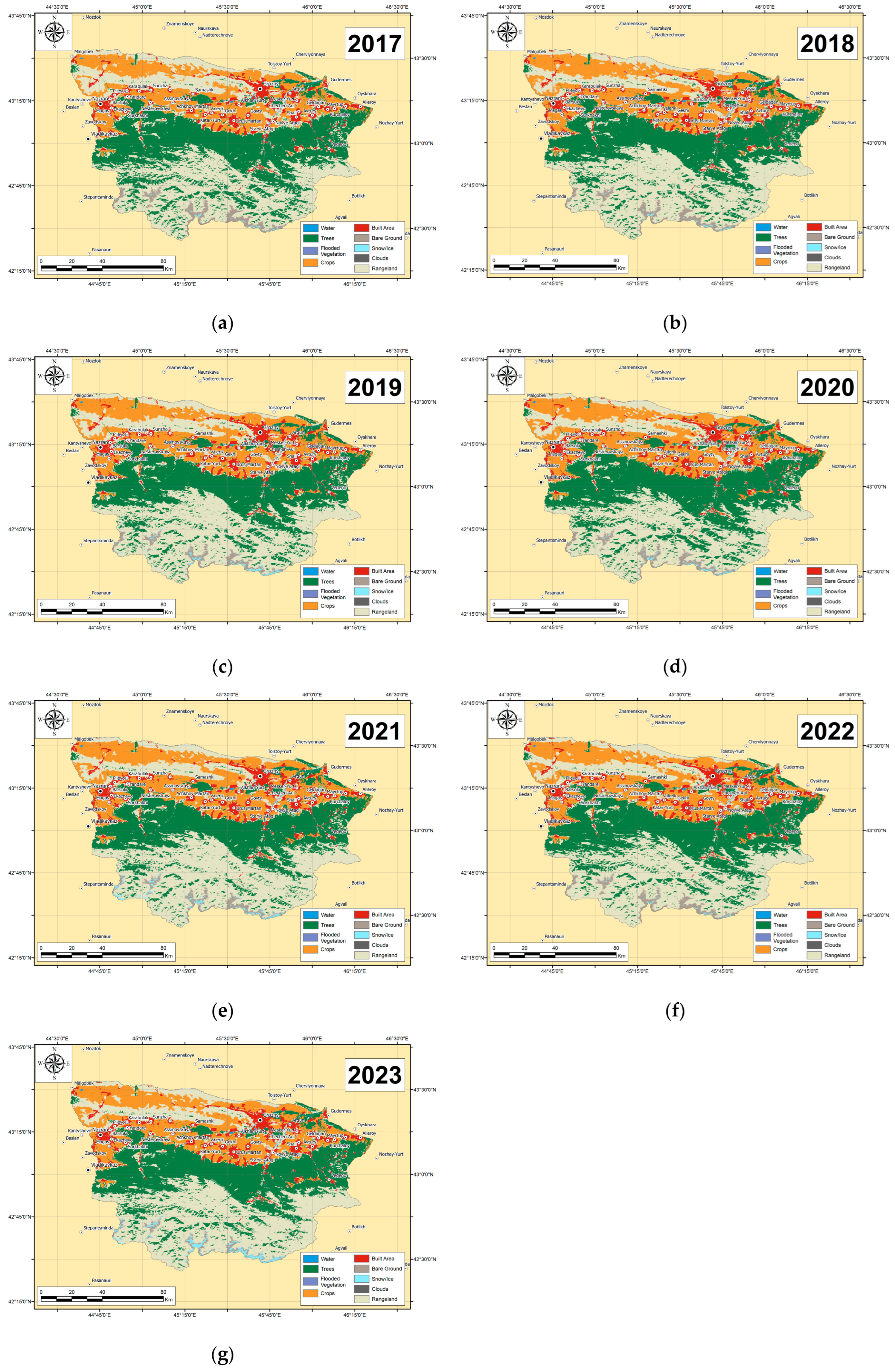
Forests cover a total area of 352.7 thousand hectares in the Chechen Republic, representing 21.8% of the republic’s total area. The average forest cover is 20.1%. The highest forest cover is found in the Shatoysky, Nozhay-Yurtovsky, and Vedensky districts (62.9%, 44.5%, and 42.5% respectively), whereas Shelkovsky, Naursky, and Nadterechny districts have significantly lower forest cover (6.1%, 4.7%, and 4.5%). All forests in the Chechen Republic are designated as protective forests, covering a total area of 352.7 thousand hectares, with 323.7 thousand hectares covered by forest vegetation, 329.7 thousand hectares classified as forest land, and 23.0 thousand hectares as non-forest land [58].
Protected areas in the Chechen Republic cover a total of 190,983.8 hectares, representing 11.84% of the republic’s total area. The Chechen Republic’s network of specially protected natural territories comprises nine state natural reserves of regional significance and 41 natural monuments of regional significance [59].
Mining, as a component of industry, plays a leading role in nature management within the Chechen Republic. Preliminary data from the Chechen Republic’s statistical agency as of 31 December 2022, indicates that the value of shipped products from these economic activities totaled 51,537 million rubles, broken down as follows:
  • Mineral extraction: 4319.3 million rubles (103.4% of the same period last year, which was 4176.7 million rubles).
  • Manufacturing: 12,104.1 million rubles (105.8% of the same period last year, which was 11,443.8 million rubles).
  • Electricity, gas, steam, and air conditioning: 32,598.5 million rubles (111.3% of the same period last year, which was 29,285.7 million rubles) [60].
Mineral extraction in the Chechen Republic primarily involves the production of oil, associated petroleum gas, and natural gas. JSC “Chechenneftekhimprom” manages subsoil use within the republic. The exploitation of oil and gas fields is specifically carried out by OJSC “Grozneftegaz” (a subsidiary of OJSC “NK “Rosneft”). The decline in mineral production in recent years is attributed to the depletion of oil and gas reserves in fields that are nearing the end of their productive life.
It should be noted that the potential of other mineral deposits is not fully realized. Currently, deposits of clay and limestone for cement raw materials, gypsum and anhydrite, building stone, brick and expanded clay clays, limestone for lime production, sand and gravel mixture, and construction and silicate sands are being developed for the production of building materials [61].
In 2024, the Chechen Republic had 967.7 thousand hectares of agricultural land, representing 59.8% of the total land area. Crop production is slightly less prominent than animal husbandry in terms of overall agricultural output. The total sown area is 306.7 thousand hectares, representing 19.1% of the republic’s land. Household farms are the leading producers, primarily engaged in livestock production, while large agricultural organizations mainly focus on crop production. The most common crops are grains and legumes, industrial crops, and fodder crops [62].
The Chechen Republic’s industrial sector includes “manufacturing industries” and “electricity, gas, steam, and air conditioning” [60].
Priority sectors within the industrial economy include manufacturing industries, which encompass mechanical engineering and metalworking, instrumentation, rubber and plastics production, electrical equipment manufacturing, building materials production, woodworking, printing, light industry, machinery and equipment repair and installation, and other manufacturing activities. The largest contribution comes from the “Production of other non-metallic mineral products” sector, which primarily refers to building materials companies.
The petrochemical industry historically formed the backbone of the Chechen Republic’s economy, with a processing capacity of up to 24 million tons of oil per year. However, wartime destruction severely damaged production facilities and disrupted established economic relationships. The resulting market gap prompted the development of competing enterprises in other regions, intensifying competition for Chechen companies seeking to rebuild. Consequently, the industry remains largely unrepaired. Oil extraction currently contributes over 15% to the total industrial output, but oil refining is almost entirely absent [63].
Settlement lands occupy 104.1 thousand hectares, representing 6.7% of the republic’s total area [62].
Grozny, centrally located within the Chechen Republic, is the administrative and regional center and forms the central element of the republic’s planning structure. The territory of Chechnya exhibits a linear-central organization, with the Terek, Sunzha, and Argun rivers serving as natural axes. Major transportation corridors and a significant portion of the population are aligned along the mountain and foothill valleys, creating the primary and secondary planning axes and regional centers.
The republic’s planning structure features several key axes. Two primary, latitudinally oriented linear axes follow the Terek and Sunzha rivers, encompassing major transportation routes:
  • The “Rostov-on-Don—Baku” and “Prokhladny—Beslan—Grozny—Gudermes” railway lines;
  • the “Caucasus” and “Stavropol—Prokhladnoye—Mozdok—Kizlyar—Krainovka” highways.
Two secondary planning axes are meridionally oriented, one following the Argun River and the Grozny—Shatoy—Itum-Kale highway, and the other following the Grozny—Vedeno—Botlikh road [64].
Nature Management in Azerbaijan
Azerbaijan has 10 national parks (421.4 thousand hectares), 10 state natural reserves (120 thousand hectares), and 24 natural wildlife refuges (350.8 thousand hectares), comprising a total of 10.3% of the country’s area. Forested areas cover 1040 thousand hectares, accounting for 12% of the total area. Industrial forestry is absent; only sanitary logging is practiced. Agricultural lands occupy 4779.6 thousand hectares, representing 55.19% of the republic’s territory. Hayfields and pastures account for the largest share of this land (2414 thousand hectares), while perennial crops occupy 237.5 thousand hectares. Livestock production accounts for 52.2% of agricultural output, while crop production accounts for 47.8% [65].
The establishment of a free market economy in the agricultural sector has increased the economic activity of various entities involved in the production, sale, processing, and servicing of agricultural products. During this period, individual agricultural enterprises, organizations, entrepreneurs, farmers, and households operated within the country’s agricultural sector. Their productivity varied based on territorial and structural characteristics, resulting in the production of diverse products. In 2020, agricultural enterprises and organizations accounted for 9.9% of the country’s total agricultural output, while individual entrepreneurs, family farms, and households accounted for 90.1%. Agricultural enterprises and organizations play a larger role in livestock production.
Azerbaijan’s favorable climate, natural resources, and workforce support the development of nearly all agricultural sectors. Production of various crop and livestock products, along with the food processing industry, has been increasing year by year [66].
Population distribution in Azerbaijan is uneven. The average population density across the country exceeds 92 people/km2. The Baku metropolitan area has a density of 840 people/km2 (400 people/km2 in the Absheron economic region), while the Lankaran Lowland has 170 people/km2. Higher population densities are also found on the Karabakh Plain, along the Kura and Araz rivers, and along major railway and highway routes. These areas are primarily located in the plains and foothills. Sparsely populated areas include the high-mountain regions and parts of the Gobustan, Jeyranchol, Shirvan, and Mughan plains. The republic’s rural population is 4,048,200, residing in 4310 rural settlements (villages and towns), comprising 49.3% of the total population [67].
Azerbaijan has a long history of oil extraction, spanning over 100 years. The earliest fields included Balakhani, Sabunchi, Ramana, Surakhani, Bibi-Heybat, and Binagadi. Although onshore oil reserves are dwindling, new deposits have been discovered in the Caspian Sea, such as “Azeri”, “Gunashli”, “Chirag”, “Shahdeniz”, and “Karabakh”. The largest of these is the “Azeri” field, which is rich in both oil and gas. In terms of natural gas production, 90% comes from the Caspian Sea shelf, with “Shahdeniz” being the largest gas field. he largest onshore deposits are Garadag-Gobustan and Gurgan-Zira. Azerbaijan produces six billion cubic meters of gas annually. Industrial enterprises are heavily concentrated in the Absheron economic region, encompassing areas such as Baku-Sumgayit, Ganja-Dashkesan, Ali-Bayramli-Baku, Baku-Yevlakh, Baku, Nakhchivan, Lankaran, Sheki, and Khachmaz, which also represent the country’s main industrial corridors 68. Over the past decade, industrial output has nearly doubled, largely driven by the oil sector. Consequently, the oil industry’s growth rate has consistently outpaced overall industrial growth in recent years. The past decade has seen significant progress in the metallurgical and machine-building sectors, which are closely linked to the oil industry. “Bashnefteprommash” is a major player in oil engineering, exporting its products to 40 countries. Machine-building output has increased nearly 15-fold during this period, and the sector’s share in the oil refining industry has reached 21.5%. In recent years, Azerbaijan’s industrial structure has gradually become more optimized, with the share of the mining sector decreasing and the share of the manufacturing sector increasing [68,69].
The machine-building complex encompasses sectors such as energy, electrical engineering, radio electronics, instrumentation, machine tool manufacturing, transportation, and agriculture. Azerbaijan’s chemical industry relies on local resources, including oil and gas, table salt, iodine-bromine drilling waters, and non-ferrous metal waste, along with some imported raw materials. The largest chemical enterprise in Azerbaijan is the Sumgayit “Khimprom” Association. Metallurgy is also experiencing active development due to the availability of abundant raw materials and local energy resources, such as oil and natural gas. The major centers for ferrous metallurgy in Azerbaijan are Sumgayit, Baku, and Dashkesan. Dashkesan is also the country’s largest mining center. Azerbaijan possesses sufficient deposits of fuel minerals, molybdenum, mercury, and polymetallic ores to support robust development of its non-ferrous metallurgy sector. This sector includes the Sumgayit and Ganja aluminum plants, the Baku and Ganja non-ferrous metal processing plants, and the Sumgayit aluminum rolling plant. In terms of output volume, the light industry and the food industry are also leading sectors in Azerbaijan, ranking second and third, respectively [68,69].
Nature Management in Iran
Iran has a total of 284 protected areas, covering 17,735,085 hectares. This includes 31 national parks and 48 wildlife habitat protection areas, covering a total of 5,832,889 hectares. Kerman province has the largest protected area at 2,405,944 hectares, while Qazvin province has the smallest at 25,454 hectares [70].
Protected areas managed by Iran’s Department of Environment (DoE) cover over 10.34% of the country. These areas are categorized into four management types: National Parks, Wildlife Habitat Protection Areas, Reserves, and National Natural Monuments. The DoE also manages over 154 hunting-prohibited zones, totaling more than five million hectares. In addition, Iran has 24 Ramsar Convention wetlands (Flooded Vegetation) and numerous areas important for wintering birds [65].
The total forest area in Iran is 14,319,063 hectares. The provinces with the highest forest cover are Mazandaran in the north, the Caspian region, Lorestan, and Kohgiluyeh in the southwest.
Agriculture contributes the smallest share to Iran’s GDP, accounting for 12.5% [71]. Within agricultural lands, pastures occupy the largest portion (29.477 million hectares), followed by cultivated lands (15.7 million hectares) and perennial plantations (1.891 million hectares). Regarding land ownership, 75.9% of agricultural land is held by individual entrepreneurs and households, 23.5% by temporary land users, and only 0.2% by registered companies and organizations [72].
Of Iran’s arable land, 29% is under irrigation, 42% is rain-fed, 18% is undergoing fertility restoration without cultivation, and 11% is also undergoing restoration, but with irrigation. The primary crops cultivated are wheat (57% of arable land) and barley (15% of arable land) [70].
The suitability classification of Iran’s arable land reveals that approximately 52% (13 million hectares) is located in areas with low or very low suitability, based on rainfall assessment. Of particular concern are 4.2 million hectares (17% of the total agricultural land) deemed unsuitable for cultivation. Conversely, about 3.4 million hectares (14%) are considered highly suitable for agriculture. However, agricultural expansion in these highly suitable areas is limited, as all available land in these classes is already under cultivation [73].
In 2021, Iran’s population was 23.7% rural and 76.3% urban. Administratively, the country is divided into 31 provinces, 429 sub-provinces, 1058 counties, 1246 cities, and 2589 rural agglomerations. Recent decades have seen increased population growth and urbanization in Iran. Urbanization rates have nearly doubled, and the urban population has increased sixfold. Since the 1920s, urbanization trends in Iran have pointed towards centralization in major cities like Tehran, Mashhad, and Tabriz. Tehran has the highest urban population, followed by Khorasan-Razavi. Provinces in desert regions (such as Qom, Yazd, and Semnan) have low urbanization rates [74].
Iran holds the third-largest oil reserves and the second-largest gas reserves globally. Its oil reserves constitute 24% of the Middle East’s total and 12% of the world’s. A member of OPEC, Iran is also the organization’s fifth-largest oil producer. In 2021, Iran ranked third in natural gas production and second in reserves, possessing about 17% of the world’s natural gas. As of 2021, natural gas reserves totaled 1200 trillion cubic feet, placing Iran second only to Russia [75]. Despite accounting for only 18% of GDP, the oil sector remains Iran’s most important source of foreign exchange. Crude oil, condensate, natural gas, petroleum products, and petrochemicals are key Iranian exports. Iran also possesses substantial deposits of other minerals and metals, which are currently under development [76].
Iran is a significant exporter of both iron ore and steel, ranking seventh globally in steel production in 2023. The Chadormalu, Gol-e-Gohar, and Sangan mines are Iran’s largest iron ore producers. Expansion plans are underway for both the mining and steel industries [77].
Development is underway at major copper mines, including Miduk, Sarcheshmeh (both in Kerman province), and Sungun (Azerbaijan province).
The production of construction materials is also well developed. According to the US Geological Survey, Iran ranked seventh in global cement production in 2023.
Fars and Khuzestan Cement Co, located in Alborz province, is the largest cement producer in Iran, with a production capacity of approximately 31 million tons per year. Semnan province in north-central Iran is the leading producer of gypsum, with an estimated output of 10 million tons per year. Other significant gypsum-producing provinces include Bushehr and Hormozgan in southern Iran, and Tehran province in northern Iran, which together produce an estimated six million tons per year [78].

3.1.2. Characteristics of Nature Management in Key Areas

Sunzha River basin. Approximately 21% of the basin area is dedicated to environmental conservation efforts. The largest specially protected natural areas within the basin are the Pshav-Khevsureti National Park, the Erzi Reserve, the Ingushsky State Nature Reserve (federally managed), and the Soviet State Nature Reserve. These are all situated in the southern mountainous region of the basin, in its upper reaches (Figure 3).
Beyond the formally protected areas, forest cover plays a significant role in the Sunzha River basin, encompassing 3199 km2, or roughly 23% of the basin’s total area. These forests are designated as protective, holding high conservation value, and are therefore not subject to commercial exploitation. This designation further contributes to the preservation of the basin’s ecosystems.
In 2023, arable lands utilized for agriculture cover 2327 km2 within the Sunzha River basin, representing 19.6% of its total area. In terms of agricultural production, households primarily focus on livestock farming, while larger agricultural organizations mainly produce crops. The most common crops include grains, legumes, industrial crops, and fodder crops. Crop production is slightly less significant than livestock production in terms of overall output [62].
Built-up areas (settlement nature management) occupy 879.7 km2, or 7.4% of the Sunzha River basin. The river network (Terek, Sunzha, and Argun rivers) acts as a natural axial element, shaping the linear-centered settlement planning structure of the Chechen Republic, where the majority of the basin is located. Two primary east–west axes follow the Terek and Sunzha rivers, encompassing key transportation routes. The main transport infrastructure and a significant portion of the population are situated along mountain and foothill valleys, forming primary and secondary planning axes and centers. This concentration exerts additional anthropogenic pressure on the Sunzha River valley [64].
Oil production accounts for over 15% of total industrial output in the region. According to the state register of mineral deposits and occurrences, the Sunzha River basin contains several oil and gas fields, including Datykhskoye, Khayan-Kortovskoye, Khankalskoye, and Oktyabrskoye. Deposits of construction materials are also exploited, such as clay for expanded clay aggregate (Chir-Yurtovskoye), gypsum (Chanakhoyskoye), and gravel and pebble material for ballast and concrete aggregate (Chechenaulskoye) [79]. The oil refining and petrochemical industry, however, suffered near-total destruction during armed conflicts, leading to a disruption of economic ties. This sector has yet to recover [63].
Sulak and Ulluchay River basins. In the Sulak River basin, approximately 16% of the area is dedicated to environmental conservation. Protected areas include the Tlyaratinsky State Nature Reserve, the Charodinsky State Reserve (of republican significance), and the Tusheti National Park, located in the south and southwest. Forests cover 1680 km2 (12.01%) and are concentrated in the upper and middle reaches. The Ulluchay River basin contains no specially protected natural areas. Forests cover 164 km2 (12.39%), with the largest area located in the middle reaches in the south. Agricultural land (arable) accounts for 50.15 km2, or 3.79% of the basin’s total area (Figure 3). In 2023, agricultural land use in the Sulak River basin totaled 179.6 km2, representing 1.28% of the basin’s area. The majority of agricultural production originates from the mountainous and central zones (including lowland outwintering pastures, or “kutan” farms, associated with the mountainous regions). Livestock farming is the primary agricultural specialization in the region, focusing on cattle, small ruminants, and poultry. Transhumant pastoralism (seasonal grazing) plays a significant role in the agricultural system, influencing land-use patterns in both the mountainous and lowland areas. Crop production and the production of related food products also play a significant role in the region’s agricultural output, including grains, industrial crops, fruits, berries, grapes, vegetables, melons, and potatoes. Agricultural production is largely characterized by small-scale farming, especially in crop production. Households account for over 85% of the output in this sub-sector (with potatoes, vegetables, and fruits contributing 96–99%). Furthermore, more than 100,000 hectares of arable land, an extremely scarce resource (per capita availability is five times lower than the Russian Federation average in the Republic of Dagestan), remain unused. The primary cause of this underutilization is unresolved land tenure issues and the outdated technical and technological infrastructure within the agricultural sector [57].
Urbanized areas comprise 205.6 km2, representing 1.47% of the Sulak River basin. The greater part of the basin falls within the mountainous territory of Dagestan, including the following administrative districts: Akhvakhsky, Botlikhsky, Gumbeovsky, Gergebilsky, Untsukulsky, Tlyaratinsky, Khunzakhsky, Shamilsky, Tsumadinsky, Tsuninsky, and the Bezhtinsky sector (collectively forming the Untsukul Economic Zone in the western part of the region), along with the Akushinsky, Gunibsky, Kulinsky, and Laksky districts. This area accounts for 16.6% of the population of the Republic of Dagestan, yet economic activity is limited. Further downstream, the Sulak River basin encompasses the territories of the Kazbekovsky, Kizilyurtovsky, and Kumtorkalinsky districts. These districts are part of central Dagestan, which accounts for 57.8% of the republic’s total population [56].
Settlement areas in the Ulluchay River basin cover 32.2 km2, accounting for 2.9% of the total area. The basin primarily encompasses the Dahadayevsky district, along with portions of the Kaytagsky, Kulinsky, Agulsky, and Derbent districts—effectively representing parts of mountainous and southern Dagestan. The industrial potential of the mineral and raw material base in the Republic of Dagestan is not fully exploited, except for oil, gas, and construction materials. Ore resources remain undeveloped. Currently, the following mineral resources are extracted from Dagestan’s subsoil: oil, gas, groundwater (fresh, mineral, and thermal), seashells (for animal and poultry feed), and various construction materials (limestone for sawing and facing, brick clays, sands, rubble stone, and sand and gravel mixtures). The primary subsurface users are Rosneft-Dagneft and Dagneftegaz [56]. The industrial sector is composed of manufacturing within the machine-building complex and light industry. The structure of industrial output is dominated by food and beverage production (over 53%), followed by non-metallic mineral products (over 14%). Other significant sectors include machinery and equipment (9.5%), computers, electronic and optical products (7%), furniture (over 6%), coke and petroleum products (3.7%), and metalworking (1.6%). Textiles and related industries contribute a smaller share (1.3%). Industrial development is primarily concentrated in the lower reaches of the Sulak River, within Central Dagestan. In contrast, the mountainous regions exhibit limited industrial activity, even though they possess considerable potential for developing energy resources (including renewable sources) and the food processing industry, which have been historically underutilized [56].
Karachay and Atachay River Basins. Neither the Karachay nor the Atachay River basins contain any specially protected natural areas. The Karachay River basin has 37 km2 of forest cover (9.16%), mostly in the middle reaches. The Atachay River basin has 144 km2 of forest cover (38.23%), mainly in the southwest of the basin. In 2023, agricultural land used for arable farming in the Karachay River basin was 101.6 km2, representing 25.15% of the total area. In the Atachay River basin, 10.5 km2 is used for arable land, or 2.79% of the total area (Figure 3). Hayfields and pastures account for a large portion of the land in both basins [65].
The majority of agricultural production is generated by individual entrepreneurs, family farms, and households. Agricultural enterprises and other organizations play a more significant role in livestock production.
Thanks to favorable natural conditions and a skilled workforce, the republic is well-positioned to cultivate diverse agricultural sectors. The production of crops, livestock, and processed foods continues to expand year after year [66].
In the Karachay River basin, settlement areas constitute 17.2 km2, or 4.26% of the basin’s total area. The basin falls within the Guba-Khachmaz economic zone and is characterized by a low population density of 80 people per square kilometer, one of the lowest in Azerbaijan. The population is predominantly rural (67%) compared to urban (33%), with larger settlements clustered in the foothills.
Settlement areas within the Atachay River basin encompass 10.4 km2, or 7.22% of its total area. The basin’s lower reaches extend into the Siazan district, while the upper reaches are located in the Khyzy district, where the population is nearly evenly split between rural (51.2%) and urban (48.8%) residents. The Siazan district hosts around 20 active industrial enterprises, while the Khyzy district has 7.
The Atachay River basin contains several deposits of construction materials, including limestone, sand and gravel, and clay, as well as an oil field. In contrast, the Karachay River basin only has developed deposits of marbled limestone and clay [80]. The main industrial enterprises are concentrated in the Absheron economic region, encompassing areas such as Baku-Sumgayit, Ganja-Dashkesan, Ali-Bayramly-Baku, Baku-Yevlakh, Baku, Nakhichevan, Lankaran, Sheki, and Khachmaz, along the country’s primary industrial transportation routes [68].
Haraz and Gorgan River basins. With approximately 41% of its area designated as specially protected natural areas, the Haraz River basin has the highest proportion among the studied basins (Figure 3). These protected areas include the Central Elburz Protected Area, Lar National Park, the Haraz Reserve, and hunting-restricted zones in the southwest. In contrast, the Gorgan River basin allocates around 13.8% of its area to specially protected natural areas, primarily the Khosh-Yeilag Nature Reserve and Golestan National Park, situated in the eastern and southern portions of the watershed. Beyond the protected areas, forest cover in the Haraz basin totals 2799 km2 (23.26%), extending across the northern macroslope of the Elburz Mountains. The Gorgan basin has less forest cover outside protected zones, with 253 km2 (6.15%) concentrated on the northern macroslope of the Elburz, closer to the basin’s central region.
The Gorgan River basin has extensive arable land, covering 4005.5 km2 (33.3% of the area), and benefits from fertile soils in its valley. In comparison, the Haraz River basin has very little arable land (35.2 km2, or 0.86%), a reflection of its mountainous landscape and use for pastures. Settlement areas are more extensive in the Gorgan Basin, accounting for 429.4 km2 (3.56%), which falls largely within Golestan province, with small portions in Semnan and North Khorasan provinces. Golestan province is characterized by a slight urban majority (52.5%) compared to a rural population of 47.5%. The Haraz Basin has less settlement area (66.6 km2, or 1.62%) and is located entirely within Mazandaran province, where the population is predominantly urban (57.8%) compared to rural (42.2%) [78].
Industrial activities in the Gorgan River basin involve the production of construction materials, specifically cement (Peyvand Golestan Cement Co.), and the extraction of bituminous coal (Iran Minerals Production and Supply Co.). Significant oil extraction also occurs in the southwestern coastal region of Iran, accounting for approximately 85% of the country’s total crude oil production [70].

3.2. Population Dynamics

Population and its dynamics were analyzed within the selected river basins using the GHS Population Grid database, covering the period 1975–2020 and providing projections for 2025 and 2030. Table 2 and Table 3 show the average maximum and average population values for the Sunzha, Sulak, Ulluchay, Karachay, Atachay, Haraz, and Gorgan River basins.
Furthermore, the average maximum and average population values were calculated for the southwestern Caspian Sea watershed and the Caspian region, as shown in Table 4.
Table 2 shows that the average maximum population values are increasing across all the river basins under consideration, except for the Sunzha and Gorgan. While the changes in the Gorgan River basin were minor, the average maximum population values in the Sunzha River basin have significantly decreased—by more than half. The projections for 2030 indicate that the decline in average maximum population values will persist in the Sunzha and Gorgan River basins.
Table 3 demonstrates an overall increase in average population values across the river basins analyzed. The projections for 2030 further indicate continued or stable growth, except in the Gorgan River basin. Between 1970 and 2020, the average population values showed the following increases: Sunzha (28%), Sulak (121%), Ulluchay (121%), Karachay (94%), Atachay (98%), Haraz (151%), and Gorgan (114%).
Examining the broader population change dynamics, we observed an increase in average population values across the entire southwestern Caspian Sea catchment and the Caspian region. Specifically, from 1975 to 2020, the growth in the southwestern Caspian Sea catchment was 109%, while in the Caspian region it was 71%.
Figure 4 illustrates the growth trends in average population values within the analyzed river catchments.
The graphs in Figure 4 demonstrate consistent growth, with a positive trend and R2 values exceeding 0.9.
The Sunzha and Gorgan River basins have the highest average population, whereas the Haraz River basin has the lowest. This disparity is primarily attributed to the higher level of development in the Gorgan and Sunzha basins, contrasting with the Haraz basin’s limited settlement areas and a significant proportion of land minimally affected by human activity.

3.3. Population Density Trends

An overview of population density trends in the southwestern Caspian region is provided below (Table 5, Figure 5).
The dynamics of average and maximum population density values in the Sunzha, Sulak, Ulluchay, Karachay, Atachay, Haraz, and Gorgan River basins are presented in Table 6 and Table 7.
The trends in the considered average and maximum population density values within the territories of the key area basins are presented in Figure 6 and Figure 7.
The analysis of Figure 6 and Figure 7 reveals that the Gorgan basin exhibits the highest maximum population density, while the Karachay and Atachay basins have the lowest. The average population density in the Gorgan and Sunzha River basins, which fall within the southwestern part of the Caspian Sea catchment, is significantly higher than the average for the entire southwestern part of the Caspian Sea catchment. The Atachay and Haraz River basins have a low average population density.
An examination of average population density reveals that the southwestern Caspian Sea watershed has seen an increase of 9 people/km2 between 2000 and 2023. Individually, the analyzed river basins showed the following increases: Sunzha (32 people/km2), Sulak (17 people/km2), Ulluchay (16 people/km2), Karachay (25 people/km2), Atachay (10 people/km2), Haraz (8 people/km2), and Gorgan (30 people/km2). Consequently, the Gorgan River basin registered the most substantial increase in population density.

3.4. Land Cover Dynamics

The study includes an analysis of land cover dynamics within the selected key areas. The results are presented in Table 8, Table 9, Table 10, Table 11, Table 12, Table 13 and Table 14 and Figure 8, Figure 9, Figure 10, Figure 11, Figure 12, Figure 13 and Figure 14.
In the Sunzha River basin (Table 8), from 2017 to 2023, the following decreased: Water cover (by 2.1 km2), Tree cover (by 377.6 km2), Flooded Vegetation (by 1 km2), and Bare ground (by 133.1 km2)—a reduction of more than half. At the same time, the following increased: Agricultural land (by 184.3 km2), Built-up areas (by 103 km2), and Rangeland (by 123 km2). The largest decrease was in Tree cover, while the largest increase was in Agricultural land.
Between 2017 and 2023, the Sulak River basin (Table 9) saw a decrease in Tree cover (by 248 km2), Flooded Vegetation area (from 0.0868 km2 to 0 km2), Agricultural land (by 17.9 km2), and Bare ground (by 3.3414 km2). Conversely, the area of Water cover (by 2.4 km2), Built-up areas (by 37.2 km2), and Rangeland (by 444.5 km2) increased. Rangeland experienced the largest increase, while Tree cover experienced the largest decrease.
Land cover changes in the Ulluchay River basin (Table 10) from 2017 to 2023 showed a decline in Flooded Vegetation (vanishing from 0.0868 km2), Bare ground (3.3414 km2), and Rangeland (50.524 km2). Conversely, Water cover (0.1375 km2), Tree cover (223.122 km2), and Built-up areas (2.4081 km2) expanded. Agricultural land remained relatively stable at approximately 50 km2. The most significant shift was the expansion of tree cover, contrasted by the decline of Rangeland.
Between 2017 and 2023, the Karachay River basin (Table 11) experienced a decrease in Bare ground (by 11.8 km2). Conversely, most other land cover types increased: Tree cover (by 3.6 km2), Agricultural land (by 2.6 km2), and Rangeland (by 6.4 km2). The area of water remained relatively stable around 50 km2, Flooded Vegetation remained near 0 km2, and Built-up areas slightly exceeded 17 km2. Rangeland showed the largest increase.
From 2017 to 2023, the Atachay River basin (Table 12) witnessed a reduction in Water cover (0.1 km2), Tree cover (11.5 km2), Agricultural land (4.8 km2), and Bare ground (3.1 km2). In contrast, Built-up areas expanded (0.5 km2), along with Rangeland (19.1 km2). The most significant decline occurred in Tree cover, whereas Rangeland exhibited the most substantial growth.
Land cover changes in the Haraz River basin (Table 13) between 2017 and 2023 reveal a significant decrease in Bare ground (189.7 km2), along with smaller declines in Water cover (3.2 km2), Tree cover (20.8 km2), and Agricultural land (1.3 km2). In contrast, only Built-up areas (12.1 km2) and Rangeland (203.7 km2) expanded. The most notable shifts were the expansion of Rangeland and the reduction of Bare ground.
Between 2017 and 2023, the Gorgan River basin (Table 14) experienced decreases in the following land cover types: Water cover (24 km2), Tree cover (by 161.9 km2), Agricultural land (by 180.8 km2), and Bare ground (180 km2). Conversely, Built-up areas (increased by 36.6 km2) and Rangeland (increased by 510.2 km2) expanded. The area of Flooded Vegetation remained relatively constant, staying around 1 km2. Agricultural land saw the largest decrease, while Rangeland saw the largest increase.
A common trend observed across nearly all basins is a substantial increase in Rangeland.

3.5. Anthropogenic Transformation

Calculations and modeling provide data on the anthropogenic transformation of the southwestern Caspian Sea catchment (Table 15, Figure 15, Figure 16, Figure 17, Figure 18, Figure 19, Figure 20 and Figure 21).

4. Discussion

River basins are fundamental to human life. When considering land cover change, it is essential to account for the influence of river basins and their transboundary and transit roles, which is a key aspect of studying land use for sustainable resource management [17]. Various studies of river basins have been carried out in Azerbaijan. For instance, Imanov et al. [81] performed a comprehensive assessment of ecological flow, including the evaluation of chemical, biological, hydrological, and morphological changes expected from disruptions to the river flow regime. Ecological flow was assessed using six hydrological methods. The analysis revealed an increase in the annual runoff volume from 13.6% to 27.1%, indicating growing pressure on this critical source of surface water. Remote sensing techniques are being actively integrated into diverse fields such as agriculture, landscape planning, and geographical research. Land-use/land-cover models and geodata sets have become a primary focus [13,15,20,26,28,35]. Mountain regions worldwide are undergoing dynamic changes due to land use transformation and climate change, making monitoring these changes essential [82]. However, mountain regions are often subject to changes in land use and climate, significantly impacting the mountain environment. For instance, forests in these regions are frequently jeopardized by illegal logging and grazing practices [83,84]. Mountain regions are also often hotspots for agricultural abandonment, leading to forest expansion, particularly on steep slopes where cultivation is labor-intensive, as seen in the European Alps [85]. Climate change has contributed to increased tree mortality in some areas but also to enhanced growth and a shifting tree line in others. Furthermore, extreme weather events, such as drought, can severely impact agricultural production, particularly in water-scarce regions [86]. It is also important to note the frequent interaction between land use change and climate change [86], and to accurately map the spatial and temporal patterns for the identification of causes of soil cover changes in mountainous regions and, ultimately, for ensuring their sustainable management.
Anthropogenic transformation is often studied through the lens of various processes, such as changes in land use and land cover (LULC) [87]. These processes drive land transformation, thermal fluctuations, thermal stress, and extensive vegetation loss, leading to increased oxygen deficiency and air pollution. A study utilized Landsat TM and OLI/TIRS remote sensing data to assess land transformation and the effects of urbanization in the Rajpur-Sonarpur municipality between 2000 and 2020. The authors found that the built-up area increased due to anthropogenic activity by approximately 12.16%. Furthermore, the area of agricultural land expanded by 2.10 km2, while the vegetated area contracted by roughly 6.52 km2 within the study area. The temperature increased by 6.97 °C over the 20-year period due to anthropogenic influence [87].
A study in Azerbaijan [88] investigated the characteristics of forest ecosystem transformation within the Agsuchay River basin to analyze the effects of anthropogenic impact. The methodology involved satellite imagery, scientific literature, and field observations on experimental plots. In another area of Azerbaijan [89], anthropogenic activities in the Caspian Sea coastal zone were classified, employing the analysis of historical and contemporary topographic maps, satellite imagery, and interviews with long-term residents. The resulting NDVI maps, along with maps depicting the dynamics of technogenic landscapes and forest ecosystems, enabled the creation of an anthropogenic transformation map, categorizing the area into five ranks based on the degree of transformation.
In the Russian and post-Soviet literature, anthropogenic transformation is frequently evaluated through the creation of land-use maps derived from the interpretation of high-resolution satellite imagery. A specific region, entirely covered by grid cells (e.g., 1x1 km), serves as the operational-territorial unit for study. Simultaneously, numerous geodata databases have become available in recent years, assisting in the assessment of anthropogenic impacts on landscapes. The historical and temporal depth of data makes the GHS Population Grid and LandScan geodata databases valuable for research on long-term spatiotemporal changes in population density and distribution. The practical importance of these databases cannot be overstated. They are widely applied in studies related to urban infrastructure planning, natural and technological disaster management, the assessment of urbanization’s environmental effects, and more. For instance, these databases can be used to develop climate change adaptation strategies, assess the vulnerability of settlements to natural disasters, or analyze spatial inequalities.
The Haraz River basin exhibited low anthropogenic transformation indicators (Table 16). Significantly, this basin has the largest proportion of specially protected natural areas among those studied. A quarter of the basin is comprised of preserved forest landscapes, while the remaining area is primarily used for grazing, an anthropogenic activity with a relatively minor impact on the overall landscape. Consequently, the basin is characterized by low anthropogenic impact based on the “degree of anthropogenic transformation,” while the “coefficient of anthropogenic transformation” indicates a slight alteration of the area. Finally, the “land degradation index” classifies the basin as a background area.
The Gorgan River exhibited higher anthropogenic transformation coefficient values, reflecting the intense agricultural activity in its valley, facilitated by favorable agroclimatic conditions. The Gorgan River basin is functionally divided into two distinct zones. The northern, flatter region features extensive agricultural development and settlements, resulting in the highest degrees of anthropogenic transformation. In contrast, the southern and southeastern portions, characterized by substantial protected areas and mountainous terrain covered in forest and meadow vegetation, exhibited minimal transformation. The Sunzha River basin, while maintaining relatively natural landscapes in its upper reaches due to the presence of significant protected areas, faces increasing anthropogenic pressure in its middle and lower sections. These areas contain agricultural lands and substantial settlements (e.g., Grozny, Nazran), resulting in the Sunzha River basin having the highest proportion of residential land use among all the studied basins.
The Atachay River basin is generally characterized as having low anthropogenic transformation. It features extensive forests, and much of the meadow-steppe land is used for grazing. In contrast to the Atachay River basin, the Sulak River basin exhibited a greater degree of transformation. The Karachay River basin displayed the highest indicators, corresponding to a moderate level of anthropogenic alteration. This is because the Karachay River basin lacks specially protected natural areas, and the proportion of preserved forest landscapes is also limited. Arable land accounts for approximately a quarter of the basin, while treeless steppe and meadow landscapes are used as pastureland.
Overall, a significant unresolved scientific issue exists regarding the calculation of anthropogenic transformation in large catchments, where approximately half of the basin area is highly transformed, and the other half is only slightly so. This is particularly true for large mountain river basins because their lower reaches are highly transformed, while their upper and, in part, middle reaches are characterized by low levels of transformation.
The high degree of degradation and anthropogenic transformation of the Karachay and Gorgan River basins is due to a complex of interrelated economic, natural, and social factors that manifest themselves most in these basins. This is due to the historical conditions of economic development within the territory of these basins, the large share of agricultural development in the river valleys, the development of urbanization, and the growth of settlements.
However, comparing the anthropogenic transformation of river basins using the methodology’s inherent scales failed to capture significant differentiation among the basins due to the broader scale of the study area. Therefore, these indicators were considered in comparison with other calculations carried out for small- and medium-sized river basins.
Anthropogenic transformation was analyzed across the river basins of the northwestern Crimean Mountains, the upper Salgir River valley, and the Fatala River basin, utilizing six key indicators. The Zapadny Bulganak River basin showed markedly higher levels of transformation compared to other studied basins. This is primarily attributable to the large, protected areas and forests found in the river basins along the northwestern Crimean slopes (Alma, Kacha, Belbek, and Chernaya rivers), coupled with a relatively small amount of agricultural land, orchards, vineyards, and settlements. A key finding is that the river basins in the southwestern part of the Caspian Sea catchment demonstrated a greater degree of transformation compared to the Crimean Peninsula (excluding the Zapadny Bulganak River basin) (Table 14) and also showed more transformation when compared to the Fatala River basin (Republic of Guinea, Africa).
As emphasized in [91,92,93], for the sustainable development of the river basin territory, basin planning must be carried out, which will include elements of territorial and landscape planning. The sustainable development of river basin territories plays a crucial role in preserving and improving the ecological status of water resources and providing favorable living conditions for people. Based on the research and personal experience of the authors, several recommendations have been identified for the sustainable development of river basins: the effective management of water resources, the development of water conservation within the arid territories of river basins, the protection of aquatic and coastal landscapes and ecosystems, and land-use planning. The work [91] emphasized that achieving sustainable development in river basins requires an integrated approach and the implementation of measures aimed at the conservation and rational use of resources within the river basin, as well as the protection of ecosystems and landscapes. The development of measures for the sustainable development of the river basin will help to find a balance between socio-economic development and nature protection, providing favorable conditions for all stakeholders, especially in a region such as the Caspian Sea catchment area.
It is important to acknowledge that the use of databases introduces limitations to the research, as they require continuous updating and modernization. Another limitation is the spatial and temporal resolution of the source data, and the software used for processing. Furthermore, it is necessary to consider that the calculated anthropogenic transformation coefficients are adaptable to various regions globally, and the spatial grid for calculations can also be modified. These limitations highlight the need for future research incorporating an expanded geographical scope, more detailed data, and interdisciplinary approaches to enhance understanding of anthropogenic transformation in the region. Despite these limitations, we believe that the proposed research methodology is applicable to other water catchment basins of the Caspian Sea and other regions worldwide.

5. Conclusions

The southwestern part of the Caspian Sea catchment has been actively developed and transformed by human activity since ancient times. Currently, the impact of anthropogenic activities within the studied region of the southwestern Caspian Sea catchment is constantly increasing. The study revealed an overall increase in the average population size and density across the entire southwestern Caspian region and in selected key areas. The most significant increases in population density, among the considered key areas, were observed in the Gorgan and Sunzha River basins, with similar increases in population size also noted in these basins. Furthermore, there was a positive trend in the growth of average population density in the Sunzha, Sulak, Ulluchay, Karachay, Atachay, Haraz, and Gorgan River basins.
Examining the dynamics of land cover types within the key areas from 2017 to 2023 reveals a consistent increase in built-up areas. Agricultural land cover also showed a widespread expansion, while the areas of underutilized Bare ground and Tree cover were diminishing. The Sunzha River basin was characterized by a prevalence of protected areas, whereas the Sulak and Ulluchay River basins were dominated by Tree cover. The Haraz and Gorgan River basins had significantly larger areas dedicated to protected natural areas compared to the Karachay and Atachay River basins. The Karachay River basin was more intensively used for agriculture, with agricultural land use predominating.
The findings indicate that the highest levels of anthropogenic transformation were observed in the Karachay and Gorgan River basins. In contrast, the Atachay and Sulak River basins were characterized by low anthropogenic transformation. Within each catchment, however, the levels of transformation were spatially heterogeneous. The areas with the highest transformation were generally located in the flat plains, regions with long-standing development, infrastructure, and established settlements. The lowest levels of transformation are characteristic of mountainous areas covered with natural forest and grassland.

Author Contributions

Conceptualization, V.T., A.N. (Aleksandra Nikiforova) and R.G.; Methodology, V.T., A.N. (Aleksandra Nikiforova), N.L., R.G. and C.N.P.; Software, V.T.; Validation, A.N. (Aleksandra Nikiforova), N.L., R.G., T.G. and A.N. (Abouzar Nasiri); Formal analysis, V.T., A.N. (Aleksandra Nikiforova), R.G., T.G. and A.N. (Abouzar Nasiri); Investigation, V.T., A.N. (Aleksandra Nikiforova), N.L., T.G., I.K. and C.N.P.; Resources, V.T., I.K. and C.N.P.; Data curation, I.K., A.N. (Abouzar Nasiri) and C.N.P.; Writing—original draft, V.T., R.G., T.G. and C.N.P.; Writing—review & editing, A.N. (Aleksandra Nikiforova), N.L., I.K. and A.N. (Abouzar Nasiri); Visualization, V.T. and T.G.; Supervision, R.G. and I.K.; Project administration, R.G. and I.K. All authors have read and agreed to the published version of the manuscript.

Funding

This work was carried out within the framework of a large scientific project “Dynamics of the geoecological state of the mountain river basins of the North-Eastern Caucasus, Azerbaijan, and Iran under conditions of climate change and growing anthropogenic load” (Agreement of the Ministry of Education and Science of the Russian Federation No. 075-15-2024-644).

Data Availability Statement

The original contributions presented in this study are included in the article. Further inquiries can be directed to the corresponding author.

Conflicts of Interest

The authors declare no conflicts of interest.

References

  1. Nikolaishvili, D.A.; Elizbarashvili, N.K.; Meladze, G.G. Evaluation of degree of landscape’s anthropogenic transformation (landscapes of Georgia). Procedia-Soc. Behav. Sci. 2011, 19, 547–555. [Google Scholar] [CrossRef]
  2. Abdullah, A.Y.M.; Masrur, A.; Adnan, M.S.G.; Al Baky, A.; Hassan, Q.K.; Dewan, A. Spatio-Temporal Patterns of Land Use/Land Cover Change in the Heterogeneous Coastal Region of Bangladesh between 1990 and 2017. Remote Sens. 2019, 11, 790. [Google Scholar] [CrossRef]
  3. Tian, C.; Cheng, L.-L.; Yin, T.-T. Impacts of anthropogenic and biophysical factors on ecological land using logistic regression and random forest: A case study in Mentougou District, Beijing, China. J. Mt. Sci. 2022, 19, 433–445. [Google Scholar] [CrossRef]
  4. Rumiantseva, O.; Komov, V.; Kutuzov, M.; Zaroual, H.; Mizina, K.; Belova, M.; Nikitin, I.; Stolyarova, A.; Mashin, D.; Vilkova, D. Hair Mercury Levels in Pregnant Women: Fish Consumption as a Determinant of Exposure. Toxics 2024, 12, 366. [Google Scholar] [CrossRef]
  5. Fu, J.; Zang, C.; Wu, M. Research on the Spatiotemporal Changes and Driving Mechanisms of Land Use in the Haihe River Basin from 1990 to 2015. Agric. Resour. Reg. China 2015, 1–12. [Google Scholar]
  6. Han, R.; Zhao, Z.; Xiao, N. Analysis of Land Use/Cover Change and Its Driving Forces in Southern Xinjiang from 2000 to 2015. Sci. Technol. Bull. 2020, 36, 24–31. [Google Scholar]
  7. Faleiro, F.V.; Machado, R.B.; Loyola, R.D. Defining spatial conservation priorities in the face of land-use and climate change. Biol. Conserv. 2013, 158, 248–257. [Google Scholar] [CrossRef]
  8. van Vliet, J.; de Groot, H.L.; Rietveld, P.; Verburg, P.H. Manifestations and underlying drivers of agricultural land use change in Europe. Landsc. Urban Plan. 2015, 133, 24–36. [Google Scholar] [CrossRef]
  9. Karlen, D.L.; Mausbach, M.J.; Doran, J.W.; Cline, R.G.; Harris, R.F.; Schuman, G.E. Soil Quality: A Concept, Definition, and Framework for Evaluation (A Guest Editorial). Soil Sci. Soc. Am. J. 1997, 61, 4–10. [Google Scholar] [CrossRef]
  10. Leul, Y.; Assen, M.; Damene, S.; Legass, A. Effects of land use types on soil quality dynamics in a tropical sub-humid ecosystem, western Ethiopia. Ecol. Indic. 2023, 147, 110024. [Google Scholar] [CrossRef]
  11. Velastegui-Montoya, A.; Montalván-Burbano, N.; Peña-Villacreses, G.; de Lima, A.; Herrera-Franco, G. Land Use and Land Cover in Tropical Forest: Global Research. Forests 2022, 13, 1709. [Google Scholar] [CrossRef]
  12. Medriano, C.A.; Chan, A.; De Sotto, R.; Bae, S. Different types of land use influence soil physiochemical properties, the abundance of nitrifying bacteria, and microbial interactions in tropical urban soil. Sci. Total. Environ. 2023, 869, 161722. [Google Scholar] [CrossRef] [PubMed]
  13. Arifeen, H.M.; Phoungthong, K.; Mostafaeipour, A.; Yuangyai, N.; Yuangyai, C.; Techato, K.; Jutidamrongphan, W. Determine the Land-Use Land-Cover Changes, Urban Expansion and Their Driving Factors for Sustainable Development in Gazipur Bangladesh. Atmosphere 2021, 12, 1353. [Google Scholar] [CrossRef]
  14. Wubie, M.A.; Assen, M.; Nicolau, M.D. Patterns, causes and consequences of land use/cover dynamics in the Gumara watershed of lake Tana basin, Northwestern Ethiopia. Environ. Syst. Res. 2016, 5, 1. [Google Scholar] [CrossRef]
  15. Goldewijk, K.K. Estimating global land use change over the past 300 years: The HYDE Database. Glob. Biogeochem. Cycles 2001, 15, 417–433. [Google Scholar] [CrossRef]
  16. Winkler, K.; Fuchs, R.; Rounsevell, M.; Herold, M. Global land use changes are four times greater than previously estimated. Nat. Commun. 2021, 12, 1–10. [Google Scholar] [CrossRef]
  17. Bora, A.; Walia, D.; Mipun, B. Land Use Cover Change and Hotspots Identification of Upper Meghna River Basin, India. Indian For. 2023, 149, 111. [Google Scholar] [CrossRef]
  18. Joseph, S.; Rahul, R.; Sukanya, S. Land Use/Land Cover (LU/LC) Changes and its impact on Soil Organic Carbon Stock in Killiar River Basin, Kerala, India: A Geospatial Approach. Curr. World Environ. J. 2021, 16, 662–664. [Google Scholar] [CrossRef]
  19. Rockström, J.; Steffen, W.; Noone, K.; Persson, Å.; Chapin, F.S.; Lambin, E.F.; Lenton, T.M.; Scheffer, M.; Folke, C.; Schellnhuber, H.J.; et al. A safe operating space for humanity. Nature 2009, 461, 472–475. [Google Scholar] [CrossRef]
  20. Rawat, J.; Biswas, V.; Kumar, M. Changes in land use/cover using geospatial techniques: A case study of Ramnagar town area, district Nainital, Uttarakhand, India. Egypt. J. Remote Sens. Space Sci. 2013, 16, 111–117. [Google Scholar] [CrossRef]
  21. Ahmad, F.; Goparaju, L.; Qayum, A. LULC analysis of urban spaces using Markov chain predictive model at Ranchi in India. Spat. Inf. Res. 2017, 25, 351–359. [Google Scholar] [CrossRef]
  22. Näschen, K.; Diekkrüger, B.; Evers, M.; Höllermann, B.; Steinbach, S.; Thonfeld, F. The Impact of Land Use/Land Cover Change (LULCC) on Water Resources in a Tropical Catchment in Tanzania under Different Climate Change Scenarios. Sustainability 2019, 11, 7083. [Google Scholar] [CrossRef]
  23. Ndulue, E.L.; Mbajiorgu, C.; Ugwu, S.N.; Ogwo, V.; Ogbu, K.N. Assessment of land use/cover impacts on runoff and sediment yield using hydrologic models: A review. J. Ecol. Nat. Environ. 2015, 7, 46–55. [Google Scholar] [CrossRef]
  24. Lin, Y.-P.; Verburg, P.H.; Chang, C.-R.; Chen, H.-Y.; Chen, M.-H. Developing and comparing optimal and empirical land-use models for the development of an urbanized watershed forest in Taiwan. Landsc. Urban Plan. 2009, 92, 242–254. [Google Scholar] [CrossRef]
  25. Patil, N.S.; Nataraja, M. Effect of land use land cover changes on runoff using hydrological model: A case study in Hiranyakeshi watershed. Model. Earth Syst. Environ. 2020, 6, 2345–2357. [Google Scholar] [CrossRef]
  26. Hussien, K.; Kebede, A.; Mekuriaw, A.; Beza, S.A.; Erena, S.H. Modelling spatiotemporal trends of land use land cover dynamics in the Abbay River Basin, Ethiopia. Model. Earth Syst. Environ. 2022, 9, 347–376. [Google Scholar] [CrossRef]
  27. Ribeiro, C.B.d.M.; Mohanty, B.P.; Filho, O.C.R.; Filgueiras, E.T.; Xavier, L.N.R.; de Araújo, A.A.M. Water Balance and the Moist Planetary Boundary Layer Driven by Land Use and Land Cover Change across the Amazon Basin. Water 2023, 15, 4052. [Google Scholar] [CrossRef]
  28. Konukcu, F.; Albut, S.; Altürk, B. Land use/land cover change modelling of ergene river basin in Western Turkey using CORINE land use/land cover data. Agron. Res. 2017, 15, 435–443. [Google Scholar]
  29. Tabunschik, V.; Gorbunov, R.; Bratanov, N.; Gorbunova, T.; Mirzoeva, N.; Voytsekhovskaya, V. Fatala River Basin (Republic of Guinea, Africa): Analysis of Current State, Air Pollution, and Anthropogenic Impact Using Geoinformatics Methods and Remote Sensing Data. Sustainability 2023, 15, 15798. [Google Scholar] [CrossRef]
  30. Livanov, A.S.; Solodovnikov, D.V. Prospects for the Application of the Land Cover Classification System GIS. In Prirodno-Sotsial’no-Proizvodstvennye Sistemy: Svyaz Nauki i Praktiki [Natural-Social-Production Systems: Linking Science and Practice]; National Research Mordovia State University named after N.P. Ogarev: Saransk, Russia, 2016; p. 20. [Google Scholar]
  31. Potaturkin, O.I.; Borzov, S.M.; Potaturkin, A.O. Methods and Technologies for Processing Multi- and Hyperspectral Remote Sensing Data of High Resolution. Vychislitel’nye Tekhnologii 2013, 18, 60–67. [Google Scholar]
  32. Elsakov, V.V.; Marushchak, I.O.; Shchanov, V.M. Mapping of Kozim river basin (Subpolar Ural) on basis of remote sensing data. Sovrem. Probl. Distantsionnogo Zondirovaniya Zemli Kosmosa 2009, 6, 360–364. [Google Scholar]
  33. Krasnoshchekov, K.; Dergunov, A.; Pnomareva, T.; Sukachev Institute of Forest SB RAS. Siberian Federal University Geospatial analysis of technogenically disturbed ecosystems in Central Siberia using satellite data in the IR range. Curr. Probl. Remote Sens. Earth Space 2022, 19, 203–216. [Google Scholar] [CrossRef]
  34. Tsarev, Y.V.; Boyko, P.O.; Pankova, V.M. Study of the Statistics of Vegetation Cover Changes in the Volga River Basin. Vestnik Nauki 2023, 2, 750–754. [Google Scholar]
  35. Tabunshchik, V.A.; Gorbunov, R.V. Dynamics of Land Cover Types within the River Basins of the Northwestern Slope of the Crimean Mountains. Geol. Geogr. Glob. Energiya 2022, 3, 78–88. [Google Scholar]
  36. Hartvigsen, M. Land reform and land fragmentation in Central and Eastern Europe. Land Use Policy 2014, 36, 330–341. [Google Scholar] [CrossRef]
  37. Hartvigsen, M. FAO Land Tenure Working Paper 24: Land Reform in Central and Eastern Europe After 1989 and Its Outcome in the Form of Farm Structures and Land Fragmentation. Available online: https://www.researchgate.net/publication/340863198_FAO_Land_Tenure_Working_Paper_24_Land_reform_in_Central_and_Eastern_Europe_after_1989_and_its_outcome_in_the_form_of_farm_structures_and_land_fragmentation (accessed on 25 October 2024).
  38. Giovarelli, R.; Bledsoe, D. Land Reform in Eastern Europe. Seattle, Washington. 2001. Available online: https://openknowledge.fao.org/items/4f3dcd04-3c94-4345-9f66-3f86ba985519 (accessed on 25 October 2024).
  39. FAO State of Forests of the Caucasus and Central Asia. Available online: https://www.fao.org/family-farming/detail/ru/c/1193348/ (accessed on 25 October 2024).
  40. Bampton, M. Anthropogenic transformation. In Environmental Geology. Encyclopedia of Earth Science; Springer: Dordrecht, The Netherlands, 1999. [Google Scholar] [CrossRef]
  41. Report on the Sustainable Development Goals. Available online: https://unstats.un.org/sdgs/report/2023/The-Sustainable-Development-Goals-Report-2023_Russian.pdf (accessed on 25 October 2024).
  42. Tabunshchik, V.; Dzhambetova, P.; Gorbunov, R.; Gorbunova, T.; Nikiforova, A.; Drygval, P.; Kerimov, I.; Kiseleva, M. Delineation and Morphometric Characterization of Small- and Medium-Sized Caspian Sea Basin River Catchments Using Remote Sensing and GISs. Water 2025, 17, 679. [Google Scholar] [CrossRef]
  43. GHSL—Global Human Settlement Layer. Available online: https://human-settlement.emergency.copernicus.eu/download.php?ds=pop (accessed on 25 October 2024).
  44. GHS-POP R2023A—GHS Population Grid Multitemporal (1975–2030). Available online: http://data.europa.eu/89h/2ff68a52-5b5b-4a22-8f40-c41da8332cfe (accessed on 25 October 2024).
  45. Freire, S.; Doxsey-Whitfield, E.; MacManus, K.; Mills, J.; Pesaresi, M. Development of New Open and Free Multi-Temporal Global Population Grids at 250 m Resolution. Population 2016, 250, 33. [Google Scholar]
  46. Dobson, J.E.; Bright, E.A.; Coleman, P.R.; Durfee, R.C.; Worley, B.A. LandScan: A global population database for estimating populations at risk. Photogramm. Eng. Remote Sens. 2000, 66, 849–857. [Google Scholar]
  47. Bhaduri, B.; Bright, E.; Coleman, P.; Dobson, J. LandScan: Locating people is what matters. Geoinformatics 2002, 5, 34–37. [Google Scholar]
  48. Kochurov, B.I. Ecodiagnostics and Balanced Development [Ekodiagnostika i Sbalansirovannoe Razvitie]; INFRA-M: Moscow, Russia, 2024; 362p. [Google Scholar] [CrossRef]
  49. OpenStreetMap (OSM). Available online: https://www.openstreetmap.org/ (accessed on 25 October 2024).
  50. ESRI LC. Available online: https://livingatlas.arcgis.com/landcoverexplorer/ (accessed on 25 October 2024).
  51. Zanozin, V.V.; Barmin, A.N.; Valov, M.V. Application of GIS and Remote Sensing Data for Assessing Anthropogenic Transformation of Territories. Vestn. Sev.-Vostochnogo Fed. Univ. Im. M.K. Ammosova Seriya Nauk. Zemle 2019, 14, 74–84. [Google Scholar] [CrossRef]
  52. Tabunshchik, V.; Gorbunov, R.; Gorbunova, T. Anthropogenic Transformation of the River Basins of the Northwestern Slope of the Crimean Mountains (The Crimean Peninsula). Land 2022, 11, 2121. [Google Scholar] [CrossRef]
  53. Mikhailov, V.A. Assessment of Anthropogenic Landscape Transformation Using GIS (Case Study of the Crimean Sivash Region). Sovrem. Nauchnye Issled. Innov. 2012, 10. Available online: https://web.snauka.ru/issues/2012/10/17103 (accessed on 25 October 2024).
  54. Tatarchuk, A.P.; Gusev, A.S.; Vyatkina, G.V. Application of GIS Technologies for Creating a Price Zoning Map for the Improvement of Serov City. Mosk. Ekon. Zhurnal 2023, 8. [Google Scholar]
  55. Khavanskaya, N.M.; Vasilchenko, A.A. Geoinformation and Cartographic Methods in the Study of the Ecologi-cal-Economic Balance of Territories. Prir. Sist. Resur. 2020, 10, 33–41. [Google Scholar] [CrossRef]
  56. State Report on the State of the Environment and the Use of Natural Resources of the Republic of Dagestan in 2021. Available online: https://05.rospotrebnadzor.ru/c/document_library/get_file?uuid=c741c07c-27f1-463d-bc3f-878573417217&groupId=10156 (accessed on 25 October 2024).
  57. Strategy of Socio-Economic Development of the Republic of Dagestan for the Period Up to 2030 (Project). Available online: https://storage.strategy24.ru/documents/community/ee5d79cd51b81ad5787d6238fed34ae2.pdf (accessed on 25 October 2024).
  58. Forest Plan of the Chechen Republic for 2019–2028. Available online: https://docs.cntd.ru/document/553236481 (accessed on 25 October 2024).
  59. On Approval of the Scheme for the Development and Placement of Specially Protected Natural Territories of the Chechen Republic for the Period Up to 2030. Available online: https://chechnya.gov.ru/wp-content/uploads/documents/199-2.pdf (accessed on 25 October 2024).
  60. About the State Program of the Chechen Republic «Development of Industry, Energy and Energy Efficiency in the Chechen Republic» for the Period 2022–2027. Available online: http://publication.pravo.gov.ru/file/pdf?eoNumber=2000202312300042 (accessed on 28 November 2024).
  61. Akhmadov, M.E.I.; Khlebnikov, K.V.; Yakubov, T.V. Analysis of the Development of the Industrial Complex of the Chechen Republic: Searching for Possible “Growth Points”. Vestn. GGNТU Gumanit. Sotsial’no-Ekon. Nauk. 2022, 18, 27. [Google Scholar]
  62. Federal State Statistics Service. Available online: https://95.rosstat.gov.ru/folder/39000 (accessed on 25 October 2024).
  63. Bisultanova, A.A. Industrial Production of the Chechen Republic: Current Development Aspects. Reg. Ekon. Teor. Prakt. 2017, 15, 1501–1515. [Google Scholar]
  64. Chechnya Today. Available online: https://chechnyatoday.com/content/view/4010 (accessed on 25 October 2023).
  65. Statistical Yearbook: Environment in Azerbaijan. Available online: https://www.stat.gov.az/news/index.php?lang=en&id=6032 (accessed on 25 October 2024).
  66. Directions of Development of Export-Oriented Agricultural Production: Dissertation for the Degree of Doctor of Philosophy. Available online: https://unec.edu.az/application/uploads/2015/02/Metanet-Hesenova-Dissertasiya.pdf (accessed on 25 October 2024).
  67. Population. Available online: https://www.azerbaijans.com/content_437_az.html (accessed on 25 October 2023).
  68. Azerbaijan Industry. Available online: https://www.azerbaijans.com/content_463_az.html (accessed on 25 October 2024).
  69. Strategic Roadmap for the Development of Heavy Industry and Mechanical Engineering in the Republic of Azerbaijan. Available online: https://minenergy.gov.az/az/dovlet-proqramlari/strateji-yol-xeriteleri (accessed on 25 October 2023).
  70. Statistical Yearbook/Iran Data Portal. Available online: https://irandataportal.syr.edu/socio-economic-data/statistical-yearbook (accessed on 25 October 2024).
  71. Iran: Economy/globalEDGE. Available online: https://globaledge.msu.edu/countries/iran/economy (accessed on 28 November 2024).
  72. FAOSTAT. Iran. Available online: https://www.fao.org/faostat/en/#country/1022 (accessed on 25 October 2024).
  73. Mesgaran, M.B.; Madani, K.; Hashemi, H.; Azadi, P. Iran’s Land Suitability for Agriculture. Sci. Rep. 2017, 7, 7670. [Google Scholar] [CrossRef]
  74. Pilehvar, A.A. Spatial-geographical analysis of urbanization in Iran. Humanit. Soc. Sci. Commun. 2021, 8, 63. [Google Scholar] [CrossRef]
  75. Islamic Republic of Iran. Political Risk Report. Available online: https://www.unav.edu/en/web/global-affairs/ (accessed on 25 October 2024).
  76. Khajehpour, B. Anatomy of the Iranian Economy. Available online: https://www.ui.se/globalassets/butiken/ui-paper/2020/ui-paper-no.-6-2020.pdf (accessed on 25 October 2024).
  77. Kordzadeh, E.; Mourão, J.M.; Schwalm, T. An Outlook to Iranian Iron Ore and Ironmaking Industries. Available online: https://www.researchgate.net/publication/329257469_AN_OUTLOOK_TO_IRANIAN_IRON_ORE_AND_IRONMAKING_INDUSTRIES (accessed on 25 October 2024).
  78. U.S. Department of the Interior. U.S. Geological Survey. 2019 Minerals Yearbook: Iran [Advance Release]. Available online: https://pubs.usgs.gov/myb/vol3/2019/myb3-2019-iran.pdf (accessed on 25 October 2024).
  79. Objects of Accounting of the State Cadastre of Deposits and Manifestations of Minerals. Available online: https://rfgf.ru/gkm/index.php (accessed on 25 October 2024).
  80. Ministry of Ecology and Natural Resources of the Republic of Azerbaijan. Environmental Protection Action Program in Azerbaijan. Available online: https://eco.gov.az/index.php?ln=az&pg=177 (accessed on 25 October 2024).
  81. Imanov, F.; Aliyev, S.; Aliyev, E.; Nuriyev, A.; Snow, D.D. Use of Holistic Environmental Flow Assessment for the Alijanchay River, Azerbaijan. Water 2024, 16, 2447. [Google Scholar] [CrossRef]
  82. Buchner, J.; Yin, H.; Frantz, D.; Kuemmerle, T.; Askerov, E.; Bakuradze, T.; Bleyhl, B.; Elizbarashvili, N.; Komarova, A.; Lewińska, K.E.; et al. Land-cover change in the Caucasus Mountains since 1987 based on the topographic correction of multi-temporal Landsat composites. Remote Sens. Environ. 2020, 248. [Google Scholar] [CrossRef]
  83. Bhatta, K.P.; Grytnes, J.; Vetaas, O.R. Downhill shift of alpine plant assemblages under contemporary climate and land-use changes. Ecosphere 2018, 9, e02084. [Google Scholar] [CrossRef]
  84. García-Ruiz, J.M.; Lasanta, T.; Ruiz-Flano, P.; Ortigosa, L.; White, S.; González, C.; Martí, C. Land-use changes and sustainable development in mountain areas: A case study in the Spanish Pyrenees. Landsc. Ecol. 1996, 11, 267–277. [Google Scholar] [CrossRef]
  85. MacDonald, D.; Crabtree, J.; Wiesinger, G.; Dax, T.; Stamou, N.; Fleury, P.; Lazpita, J.G.; Gibon, A. Agricultural abandonment in mountain areas of Europe: Environmental consequences and policy response. J. Environ. Manag. 2000, 59, 47–69. [Google Scholar] [CrossRef]
  86. Kulakowski, D.; Bebi, P.; Rixen, C. The interacting effects of land use change, climate change and suppression of natural disturbances on landscape forest structure in the Swiss Alps. Oikos 2010, 120, 216–225. [Google Scholar] [CrossRef]
  87. Halder, B.; Haghbin, M.; Farooque, A.A. An Assessment of Urban Expansion Impacts on Land Transformation of Rajpur-Sonarpur Municipality. Knowl.-Based Eng. Sci. 2021, 2, 34–53. [Google Scholar] [CrossRef]
  88. Atakishiyev, S. Anthropogenic transformation of forest ecosystems in the mountainous area of Agsuchay. Geogr. Tour. 2023, 71, 51–57. [Google Scholar] [CrossRef]
  89. Ismayilov, M.J. Anthropogenic transformation of landscapes in arid climate conditions and their risks. J. Geol. Geogr. Geoecol. 2023, 31, 653–658. [Google Scholar] [CrossRef]
  90. Lineva, N.P.; Tabunshchik, V.A. Anthropogenic transformation of the territory within the upper reaches of the Salgir River basin (Crimean Peninsula): Current state and analysis. Geopolit. Ecogeodyn. Reg. 2023, 9, 97–112. [Google Scholar]
  91. Tabunshchik, V.A.; Gorbunov, R.V. Assessment of the Geoecological Condition River Basins of the Northwestern Slope of the Crimean Mountains: Monograph; «ARIAL» LLC: Simferopol, Republic of Crimea, 2025; 224p. [Google Scholar]
  92. Molle, F. River-basin planning and management: The social life of a concept. Geoforum 2009, 40, 484–494. [Google Scholar] [CrossRef]
  93. Terrado, M.; Momblanch, A.; Bardina, M.; Boithias, L.; Munné, A.; Sabater, S.; Solera, A.; Acuña, V.; Siqueira, T. Integrating ecosystem services in river basin management plans. J. Appl. Ecol. 2016, 53, 865–875. [Google Scholar] [CrossRef]
Figure 1. Geographic location of the study area.
Water 17 02031 g001
Figure 2. Overall research scheme.
Water 17 02031 g002
Figure 3. Nature management in key areas of the following river basins: (a) Sunzha; (b) Sulak; (c) Ulluchay; (d) Atachay; (e) Karachay; (f) Haraz; (g) Gorgan.
Water 17 02031 g003
Figure 4. Average population dynamics within the Sunzha, Sulak, Ulluchay, Karachay, Atachay, Haraz, and Gorgan River basins from 1975 to 2020 (with projections for 2025 and 2030).
Water 17 02031 g004
Figure 5. Population density in the Caspian region in 2023.
Water 17 02031 g005
Figure 6. Trends in maximum population density values (persons per square kilometer) in the Sunzha, Sulak, Ulluchay, Karachay, Atachay, Haraz, and Gorgan River basins, and in the southwestern Caspian region.
Water 17 02031 g006
Figure 7. Trends in average population density values (persons per square kilometer) in the Sunzha, Sulak, Ulluchay, Karachay, Atachay, Haraz, and Gorgan River basins, and in the southwestern Caspian region.
Water 17 02031 g007
Figure 8. Land cover type dynamics (based on ESRI LC data) in the Sunzha River basin: (a) 2017; (b) 2018; (c) 2019; (d) 2020; (e) 2021; (f) 2022; (g) 2023.
Water 17 02031 g008
Figure 9. Land cover type dynamics (based on ESRI LC data) in the Sulak River basin: (a) 2017; (b) 2018; (c) 2019; (d) 2020; (e) 2021; (f) 2022; (g) 2023.
Water 17 02031 g009
Figure 10. Land cover type dynamics (based on ESRI LC data) in the Ulluchay River basin: (a) 2017; (b) 2018; (c) 2019; (d) 2020; (e) 2021; (f) 2022; (g) 2023.
Water 17 02031 g010
Figure 11. Land cover type dynamics (based on ESRI LC data) in the Karachay River basin: (a) 2017; (b) 2018; (c) 2019; (d) 2020; (e) 2021; (f) 2022; (g) 2023.
Water 17 02031 g011
Figure 12. Land cover type dynamics (based on ESRI LC data) in the Atachay River basin: (a) 2017; (b) 2018; (c) 2019; (d) 2020; (e) 2021; (f) 2022; (g) 2023.
Water 17 02031 g012
Figure 13. Land cover type dynamics (based on ESRI LC data) in the Haraz River basin: (a) 2017; (b) 2018; (c) 2019; (d) 2020; (e) 2021; (f) 2022; (g) 2023.
Water 17 02031 g013
Figure 14. Land cover type dynamics (based on ESRI LC data) in the Gorgan River basin: (a) 2017; (b) 2018; (c) 2019; (d) 2020; (e) 2021; (f) 2022; (g) 2023.
Water 17 02031 g014
Figure 15. Anthropogenic transformation of the Sunzha River basin: (a) coefficient of anthropogenic transformation; (b) land degradation index; (c) urbanity index; (d) degree of anthropogenic transformation; (e) coefficients of absolute tension of the ecological and economic balance; (f) coefficients of relative tension of the ecological and economic balance; (g) coefficient of natural protection.
Water 17 02031 g015
Figure 16. Anthropogenic transformation of the Sulak River basin: (a) coefficient of anthropogenic transformation; (b) land degradation index; (c) urbanity index; (d) degree of anthropogenic transformation; (e) coefficients of absolute tension of the ecological and economic balance; (f) coefficients of relative tension of the ecological and economic balance; (g) coefficient of natural protection.
Water 17 02031 g016
Figure 17. Anthropogenic transformation of the Ulluchay River basin: (a) coefficient of anthropogenic transformation; (b) land degradation index; (c) urbanity index; (d) degree of anthropogenic transformation; (e) coefficients of absolute tension of the ecological and economic balance; (f) coefficients of relative tension of the ecological and economic balance; (g) coefficient of natural protection.
Water 17 02031 g017
Figure 18. Anthropogenic transformation of the Karachay River basin: (a) coefficient of anthropogenic transformation; (b) land degradation index; (c) urbanity index; (d) degree of anthropogenic transformation; (e) coefficients of absolute tension of the ecological and economic balance; (f) coefficients of relative tension of the ecological and economic balance; (g) coefficient of natural protection.
Water 17 02031 g018
Figure 19. Anthropogenic transformation of the Atachay River basin: (a) coefficient of anthropogenic transformation; (b) land degradation index; (c) urbanity index; (d) degree of anthropogenic transformation; (e) coefficients of absolute tension of the ecological and economic balance; (f) coefficients of relative tension of the ecological and economic balance; (g) coefficient of natural protection.
Water 17 02031 g019
Figure 20. Anthropogenic transformation of the Haraz River basin: (a) coefficient of anthropogenic transformation; (b) land degradation index; (c) urbanity index; (d) degree of anthropogenic transformation; (e) coefficients of absolute tension of the ecological and economic balance; (f) coefficients of relative tension of the ecological and economic balance; (g) coefficient of natural protection.
Water 17 02031 g020
Figure 21. Anthropogenic transformation of the Gorgan River basin: (a) coefficient of anthropogenic transformation; (b) land degradation index; (c) urbanity index; (d) degree of anthropogenic transformation; (e) coefficients of absolute tension of the ecological and economic balance; (f) coefficients of relative tension of the ecological and economic balance; (g) coefficient of natural protection.
Water 17 02031 g021
Table 1. Data used in the study.
DataData SourceTime RangeSpatial ResolutionReference
GHS Population GridEuropean Commission/JRC в рамках прoекта Global Human Settlement Layer1975–2030 (the interval is 5 years)1 km[43,44,45]
LandScan global databaseOak Ridge National Laboratory (ORNL)2000–2023 (annually)1 km[46,47]
ESRI Land CoverESRI (ArcGIS Living Atlas)2017–2023 (annually)10 m[50]
OpenStreetMap (OSM) datasetsOpenStreetMap community2004–present (continuous)Vector data (high level of detail)[51]
Table 2. Average maximum population (persons) within the river basins.
YearRiver Basin
SunzhaSulakUlluchayKarachayAtachayHarazGorgan
197530,084480330917392725383221,230
198027,789488131878732900438423,501
198526,5015382342510523170530827,231
199025,8066102379112453478628730,157
199524,1937206396512703977650132,422
200021,7988078406912704332674030,974
200518,8628483422713754477691922,246
201016,7749151469214664587717519,601
201515,2379993523015804757743420,853
202013,90910,699563316784814755221,347
Projections for 202512,77811,423594416564780748420,966
Projections for 203011,79612,068622416344751742920,350
Table 3. Average population (persons) for river basins, 1975–2030.
YearRiver Basin
SunzhaSulakUlluchayKarachayAtachayHarazGorgan
19759918241314753
198010019251415861
1985104212816161072
1990108243218181284
1995107263619211390
2000107283820231494
2005109304022241598
20101133344242516103
20151213648262617111
20201273952262818114
Projections for 20251314155262818115
Projections for 20301354459262818114
Table 4. Average maximum and average population (persons) within the study area.
YearsSouthwestern Caspian Sea CatchmentCaspian Region
Average Maximum PopulationAverage PopulationAverage Maximum PopulationAverage Population
197594,3262351,00644
1980108,3962557,36848
1985128,0102968,31654
1990140,5923279,62159
1995141,8483498,93562
2000118,95336118,95364
2005136,60739136,60766
2010154,50841154,50869
2015170,15144170,15173
2020178,65247178,65276
Projections for 2025177,77250177,77277
Projections for 2030177,70352177,70379
Table 5. Population density dynamics (maximum, average, and minimum values) in the southwestern Caspian Sea catchment.
YearPopulation Density (Persons Per Square Kilometer)
Maximum ValuesAverage ValuesMinimum Values
200027,931.044.70
200133,139.045.30
200225,129.045.60
200327,004.047.10
200426,239.046.00
200526,431.046.20
200625,501.045.40
200723,240.044.30
200823,334.044.50
200923,531.044.80
201028,976.047.10
201128,068.048.50
201228,031.049.80
201328,377.050.20
201428,437.051.20
201528,793.051.60
201628,910.051.90
201728,249.051.50
201828,540.052.20
201928,162.052.50
202028,578.052.10
202128,894.053.10
202229,184.053.40
202329,500.053.70
Table 6. Dynamics of maximum population density values (persons per square kilometer) in the Sunzha, Sulak, Ulluchay, Karachay, Atachay, Haraz, and Gorgan River Basins.
YearRiver Basins
SunzhaSulakUlluchayKarachayAtachayHarazGorgan
20005462.02580.0793.0343.0191.010,263.013,906.0
20014343.04424.0648.0750.0321.010,013.012,697.0
20024287.04196.0684.0633.0406.010,028.012,956.0
20036373.05154.0839.0637.0408.09198.015,968.0
20046265.05116.0719.0829.0594.09246.015,970.0
20056854.04726.0653.0837.0599.09333.016,101.0
20066790.04682.0647.0855.0611.08618.015,388.0
20075121.03952.0633.0898.0611.07913.015,274.0
20085097.03933.0630.0905.0615.07900.015,326.0
20095063.03905.0631.0910.0620.07966.015,457.0
20104995.03818.0626.0917.0624.09419.015,759.0
20114879.03680.0595.01092.0707.09495.016,554.0
20125621.04484.0631.01093.0714.09502.016,600.0
20135441.04374.0649.01107.0722.09622.016,808.0
20145324.04172.0576.0907.0730.08686.016,324.0
20155322.04169.0574.0941.0854.08611.016,493.0
20165318.04167.0565.0950.0863.08231.016,374.0
20175170.03955.0524.0978.0922.08187.016,039.0
20185161.03946.0511.0984.0919.08281.016,235.0
20194859.03208.01055.0991.0891.07822.016,240.0
20203543.02453.01251.01084.0902.07956.016,530.0
20213560.02463.01239.01093.0908.08039.016,718.0
20223552.02458.01236.01100.0915.08113.016,887.0
202337543152167311511271966118,750
Table 7. Dynamics of average population density values (persons per square kilometer) in the Sunzha, Sulak, Ulluchay, Karachay, Atachay, Haraz, and Gorgan River Basins.
YearRiver Basins
SunzhaSulakUlluchayKarachayAtachayHarazGorgan
200044.03.712.315.48.614.266.5
200143.214.422.323.012.714.165.6
200243.314.324.632.815.013.468.5
200360.817.530.033.015.012.271.4
200461.517.228.931.411.611.671.4
200562.317.827.131.511.511.571.9
200661.717.726.832.211.812.268.9
200761.818.126.531.711.911.570.2
200861.518.026.432.012.011.570.7
200961.217.926.232.312.111.671.4
201060.917.926.332.512.213.680.9
201160.617.725.836.313.813.681.6
201267.319.727.536.214.013.982.6
201367.419.727.436.514.214.083.7
201467.020.028.638.814.718.389.2
201566.920.028.840.316.919.990.7
201667.020.028.740.617.121.291.3
201766.420.427.940.717.121.189.4
201866.320.427.941.117.221.590.5
201975.821.329.541.417.721.893.2
202075.321.429.640.118.321.894.6
202175.721.529.840.418.522.195.7
202275.521.529.740.718.622.496.6
202375.521.528.639.818.022.296.8
Table 8. Dynamics of land cover types (in km2) based on ESRI Land Cover data in 2017–2023 in the Sunzha River basin.
Land Cover TypesYear
2017201820192020202120222023
Water cover31.928.829.430.029.628.229.8
Tree cover4241.43905.03949.74168.93764.74061.33863.8
Flooded Vegetation1.20.60.70.30.40.30.2
Crops2142.92354.02340.52440.62426.02411.42327.2
Built areas776.7810.2815.5834.3859.1867.7879.7
Bare ground268.3234.7201.8209.4185.0222.7135.2
Rangeland4644.14768.84733.14401.54778.54511.44767.1
Table 9. Dynamics of land cover types (in km2) based on ESRI Land Cover data in 2017–2023 in the Sulak River basin.
Land Cover TypesYear
2017201820192020202120222023
Water cover95.792.692.791.193.998.198.1
Tree cover1965.01776.01755.81718.31402.91701.31717.7
Flooded Vegetation0.60.70.80.60.40.80.9
Crops197.5192.4204.6232.6208.3205.9179.6
Built areas168.4171.2172.2170.5164.4177.5205.6
Bare ground891.6759.3722.3682.9595.9682.8563.7
Rangeland10,651.910,977.511,007.411,022.611,316.811,101.111,096.4
Table 10. Dynamics of Land Cover types (in km2) based on ESRI Land Cover data in 2017–2023 in the Ulluchay river basin.
Land Cover TypesYear
2017201820192020202120222023
Water cover0.33520.2760.38840.25570.18970.34990.4727
Tree cover190.3851237.7349169.1698232.7498229.5497238.1483242.5077
Flooded Vegetation0.08680.02960.00570000
Crops50.851852.926350.095353.878752.287353.210750.1519
Built areas29.825532.205231.029133.96231.879532.655132.2336
Bare ground4.14651.94071.56161.20460.8360.81670.8051
Rangeland1048.286998.80371071.6671001.8661009.174998.7357997.7568
Table 11. Dynamics of land cover types (in km2) based on ESRI Land Cover data in 2017–2023 in the Karachay River basin.
Land Cover TypesYear
2017201820192020202120222023
Water cover0.30.30.30.30.30.30.3
Tree cover39.243.642.540.840.542.142.8
Flooded Vegetation0.000.000.000.000.090.000.00
Crops99.0100.1100.5101.8101.9102.8101.6
Built areas17.417.917.617.616.916.917.2
Bare ground17.711.39.78.46.95.95.3
Rangeland230.4230.9233.4235.1237.4235.9236.8
Table 12. Dynamics of land cover types (in km2) based on ESRI Land Cover data in 2017–2023 in the Atachay River basin.
Land Cover TypesYear
2017201820192020202120222023
Water cover0.30.10.10.10.10.20.2
Tree cover92.885.583.482.965.187.881.3
Flooded Vegetation15.315.213.614.013.111.710.5
Crops9.99.710.19.59.110.410.4
Built areas4.73.72.82.41.91.81.6
Bare ground253.7262.4266.6267.8287.4264.7272.8
Rangeland
Table 13. Dynamics of land cover types (in km2) based on ESRI Land Cover data in 2017–2023 in the Haraz River basin.
Land Cover TypesYear
2017201820192020202120222023
Water cover6.34.210.48.75.44.33.1
Tree cover269.8259.0265.1271.4262.7268.1249.0
Flooded Vegetation36.539.037.039.935.937.535.2
Crops54.556.558.761.361.764.966.6
Built areas281.3170.9132.7108.8103.296.691.6
Bare ground3461.23580.03605.53617.03641.23639.43664.9
Rangeland
Table 14. Dynamics of land cover types (in km2) based on ESRI Land Cover data in 2017–2023 in the Gorgan River basin.
Land Cover TypesYear
2017201820192020202120222023
Water cover38.029.457.752.730.428.614.0
Tree cover3184.83107.53180.43165.23028.63119.13022.9
Flooded Vegetation0.160.000.010.490.020.000.00
Crops4186.34337.24483.24521.44273.94410.04005.5
Built areas392.8397.7400.2414.3412.8415.2429.4
Bare ground203.5134.739.024.022.622.723.5
Rangeland4024.94024.03869.93852.34262.14034.84535.1
Table 15. Calculated average values of various indicators characterizing the anthropogenic transformation within river basins of the southwestern Caspian Sea catchment (Sunzha, Sulak, Ulluchay, Karachay, Atachay, Haraz, and Gorgan River basins) (based on the ESRI LC database).
IndicatorsRiver Basins
SunzhaSulakUlluchayKarachayAtachayHarazGorgan
Coefficient of anthropogenic transformation4.664.434.465.434.384.575.12
Land degradation index2.662.772.763.152.712.922.90
Urbanity Index 0.05−0.09−0.100.07−0.17−0.08−0.02
Degree of Anthropogenic Transformation2.582.732.763.232.622.922.77
Coefficients of absolute tension of the ecological and economic balance0.000.000.000.000.000.000.00
Coefficients of relative tension of the ecological and economic balance3.320.191.014.030.520.221.93
Coefficient of Natural Protection 0.590.620.600.530.610.600.65
Table 16. Comparison of anthropogenic transformation within selected river basins (compiled using [29,52,90]).
SunzhaSulakUlluchayKarachayAtachayHarazGorganFatalaThe Upper Salgir River ValleyZapadny BulganakAlmaKachaBelbekChernaya
Coefficient of anthropogenic transformation4.664.434.465.434.384.575.123.514.526.203.843.493.172.52
Land degradation index2.662.772.763.152.712.922.902.012.673.642.031.741.651.01
Urbanity index0.05−0.09−0.100.07−0.17−0.08−0.02−0.670.060.170.48−0.56−0.77−0.95
Degree of anthropogenic transformation2.582.732.763.232.622.922.771.613.344.022.301.461.361.49
Coefficients of absolute tension of the ecological and economic balance0.000.000.000.000.000.000.00-0.7111.980.250.330.280.07
Coefficients of relative tension of the ecological and economic balance3.320.191.014.030.520.221.930.250.361.460.330.280.170.11
Coefficient of natural protection0.590.620.600.530.610.600.65-------
Disclaimer/Publisher’s Note: The statements, opinions and data contained in all publications are solely those of the individual author(s) and contributor(s) and not of MDPI and/or the editor(s). MDPI and/or the editor(s) disclaim responsibility for any injury to people or property resulting from any ideas, methods, instructions or products referred to in the content.

