
Optimizing Landslide Susceptibility Mapping with Non-Landslide Sampling Strategy and Spatio-Temporal Fusion Models


Abstract
1. Introduction
2. Materials and Methods
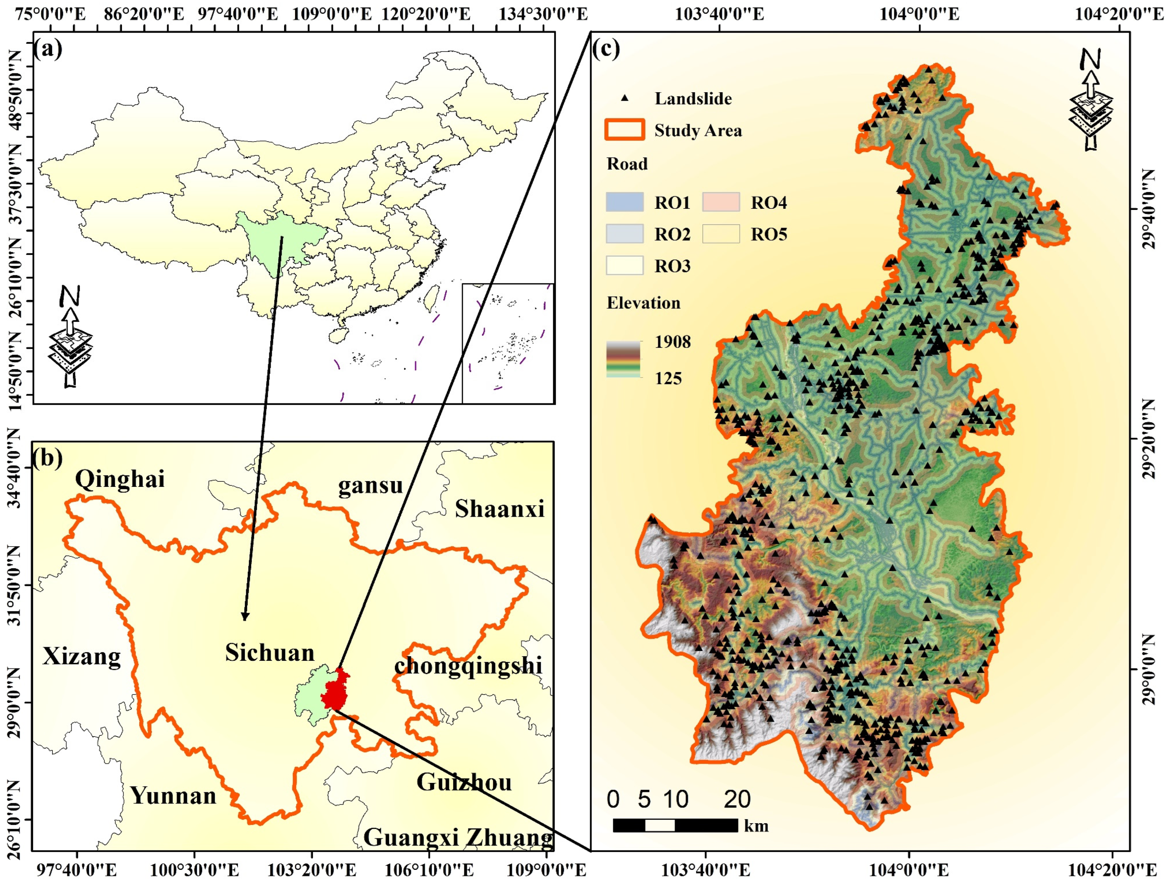
2.1. Introduction to the Study Area
2.2. Landslide Conditioning Factors
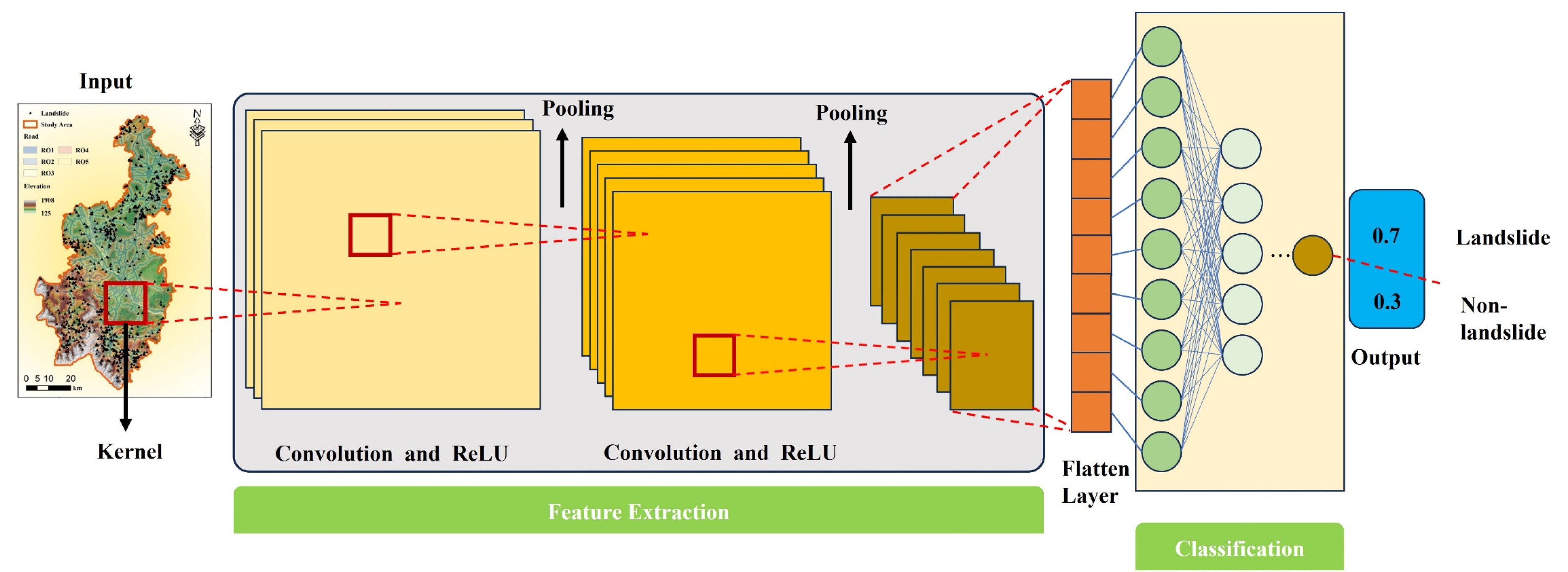
2.3. Convolutional Neural Networks
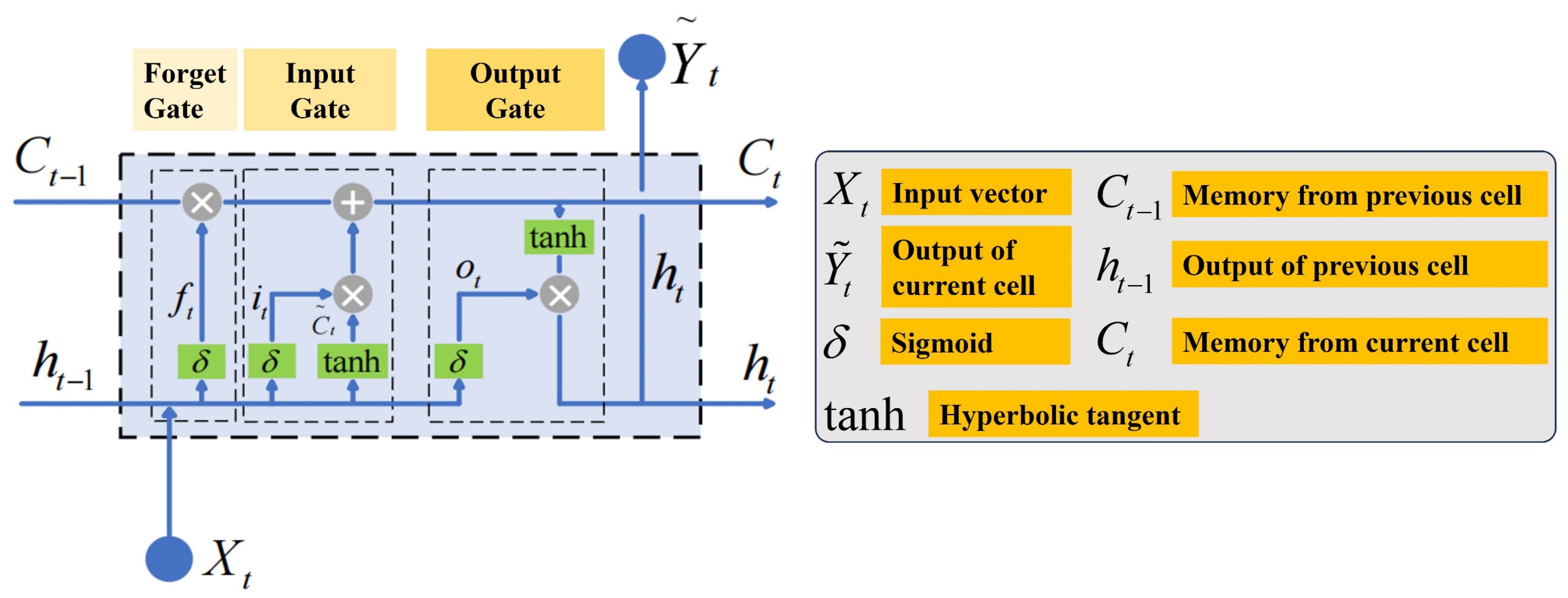
2.4. Long Short-Term Memory Neural Network
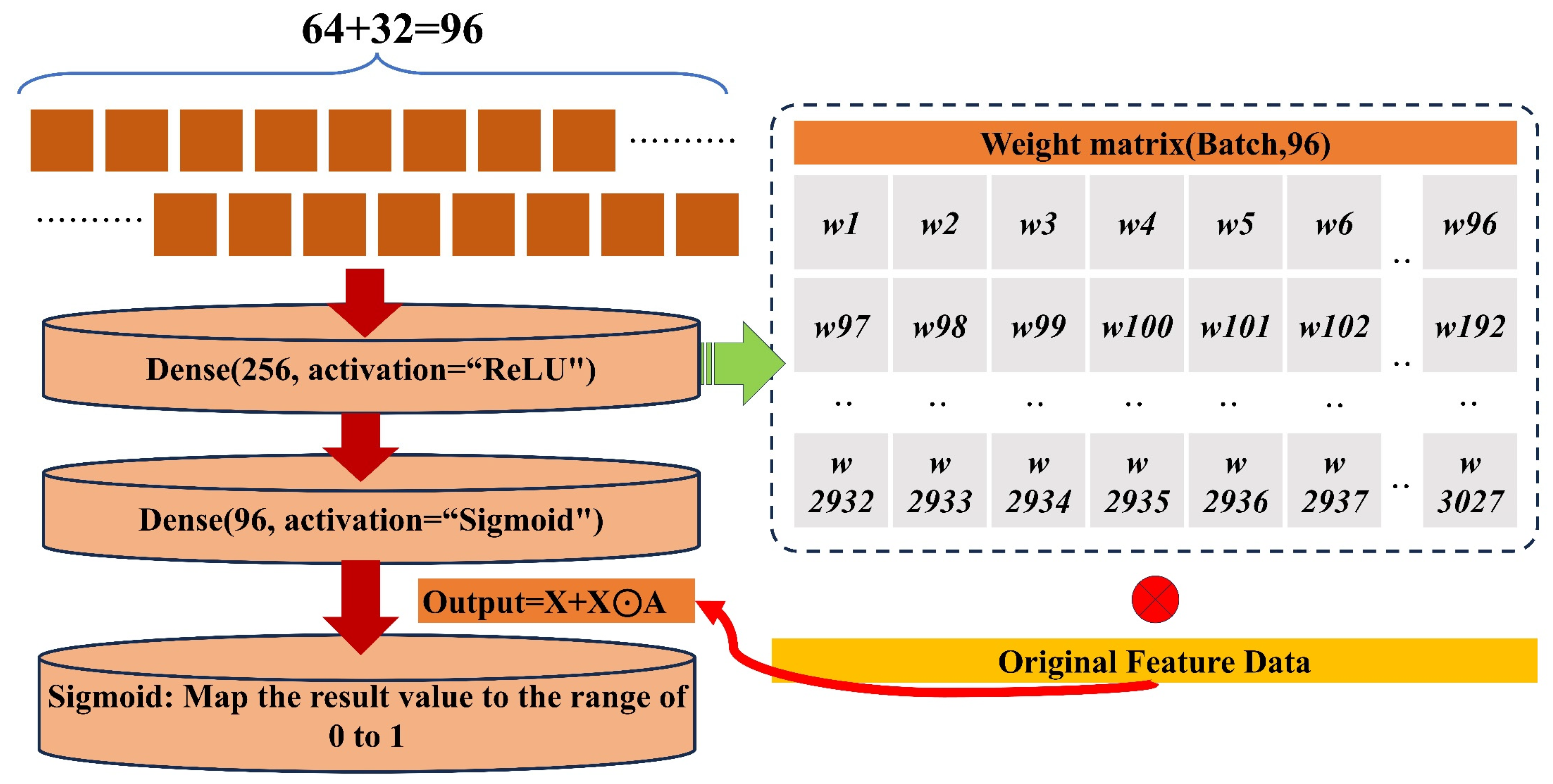
2.5. Attention Mechanism
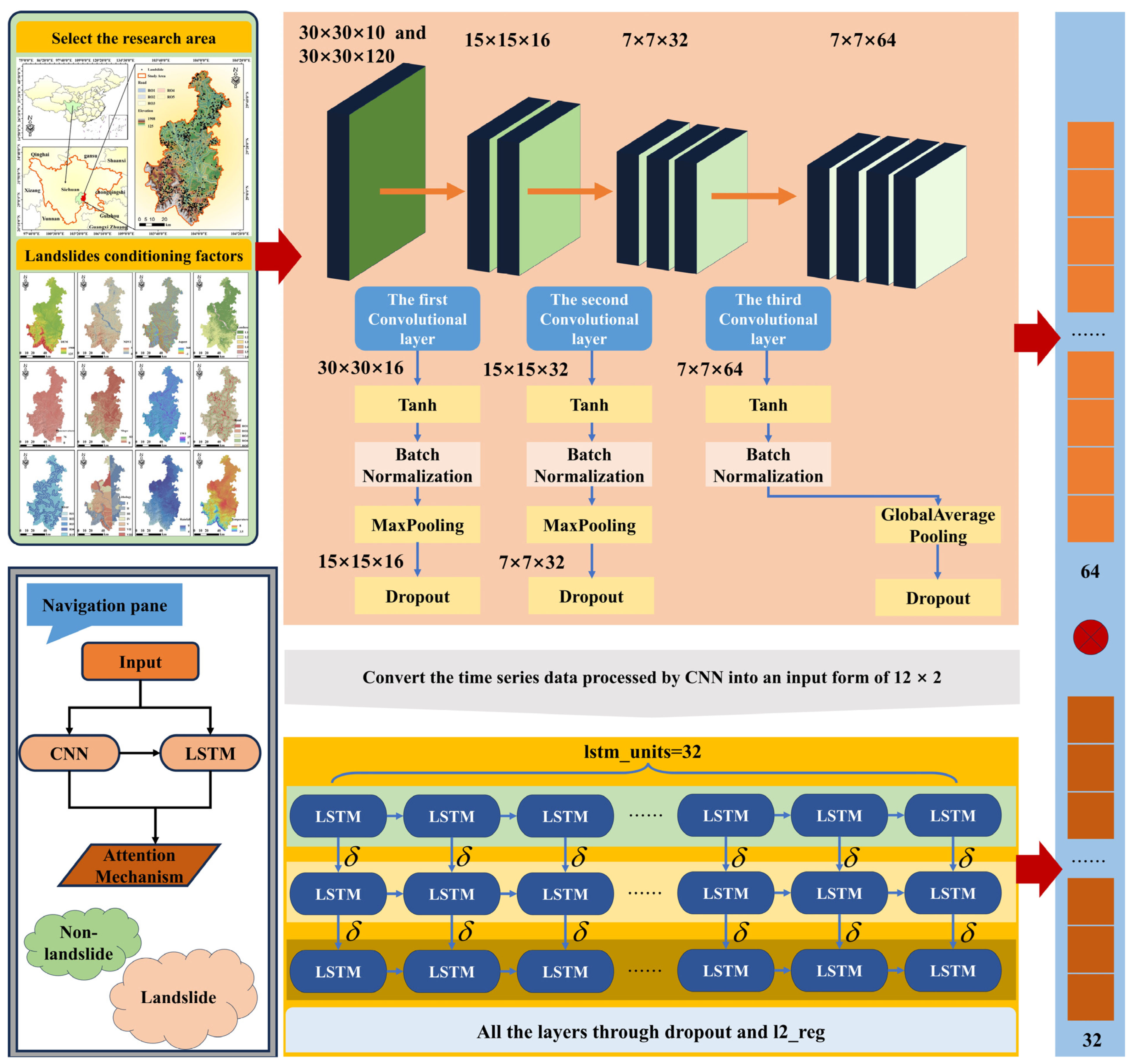
2.6. CNN-LSTM-AM
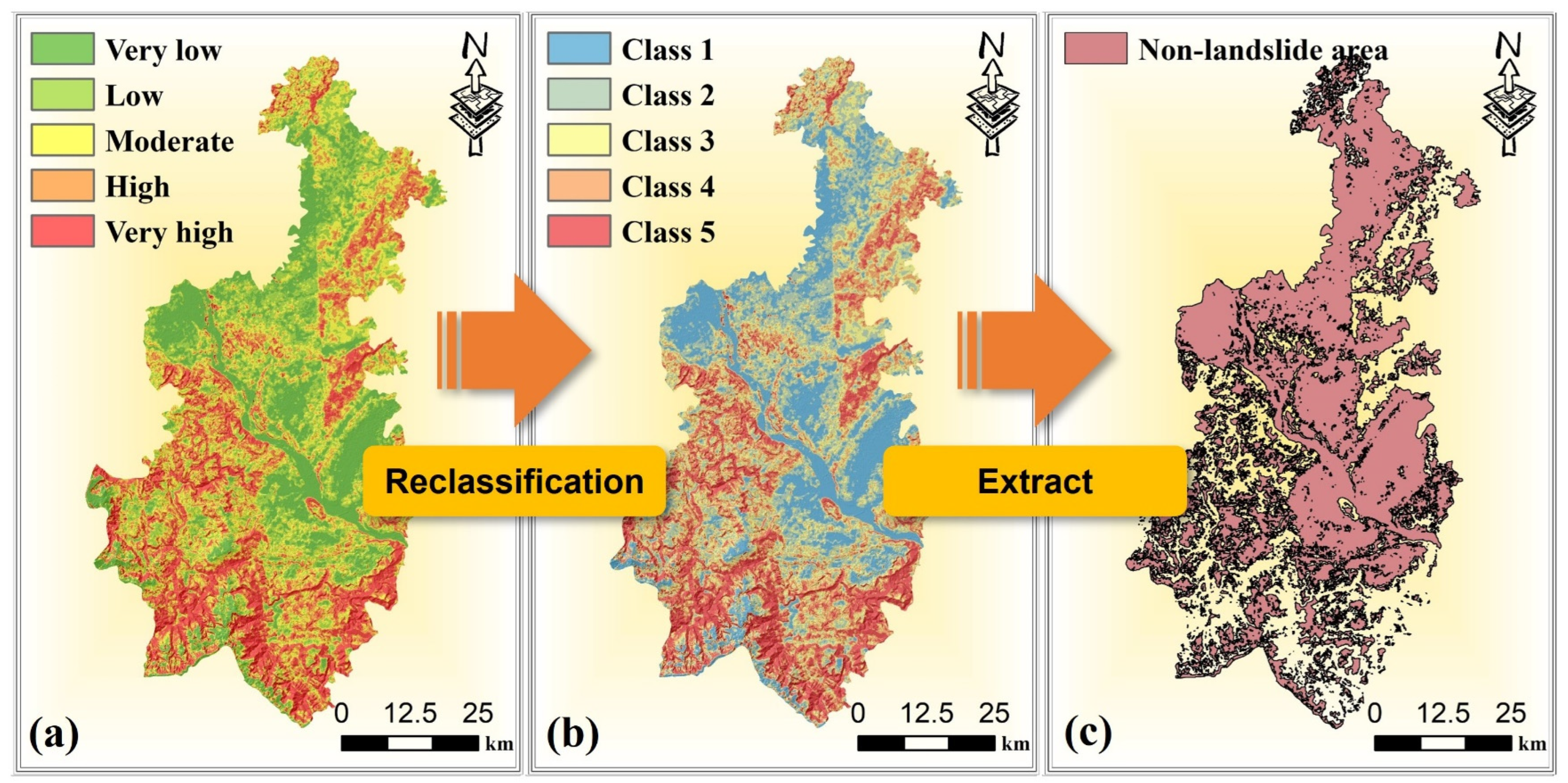
2.7. Certainty Factor Model
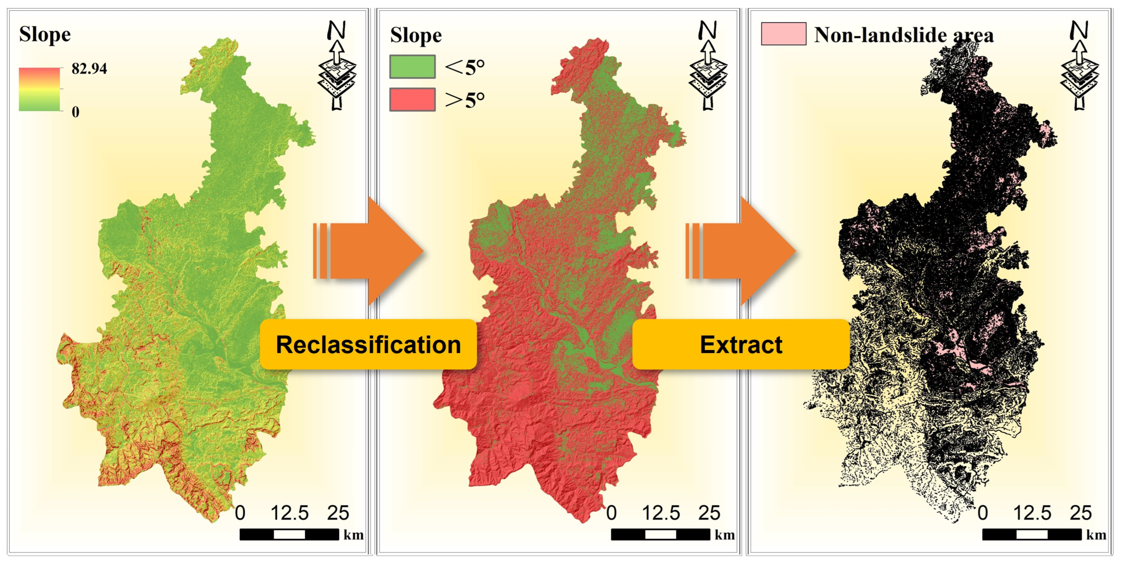
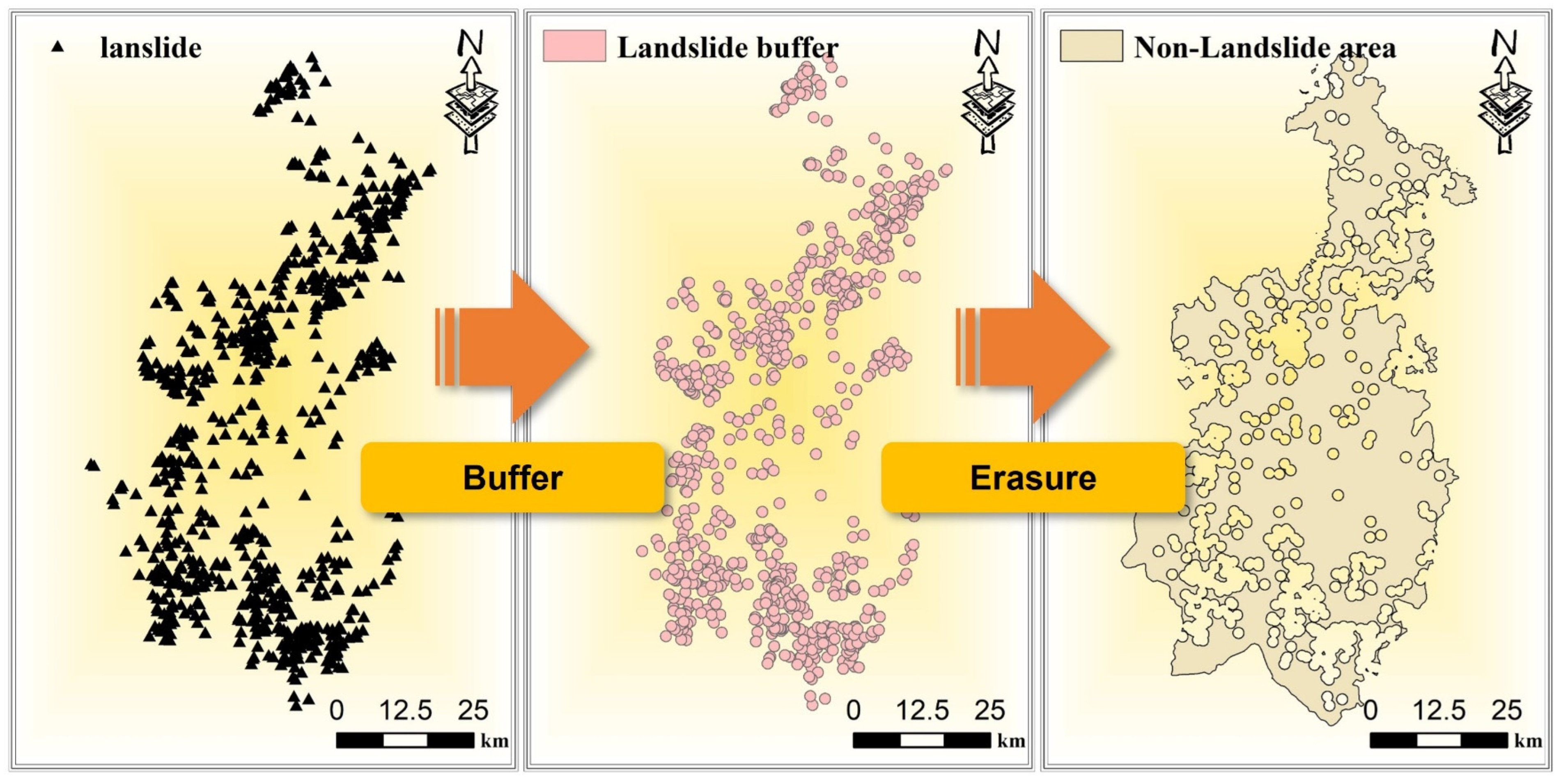
2.8. Strategies for Non-Landslide Sampling
2.9. Bayesian Optimization Model Hyperparameters
2.10. Model Accuracy Evaluation Metrics
3. Results
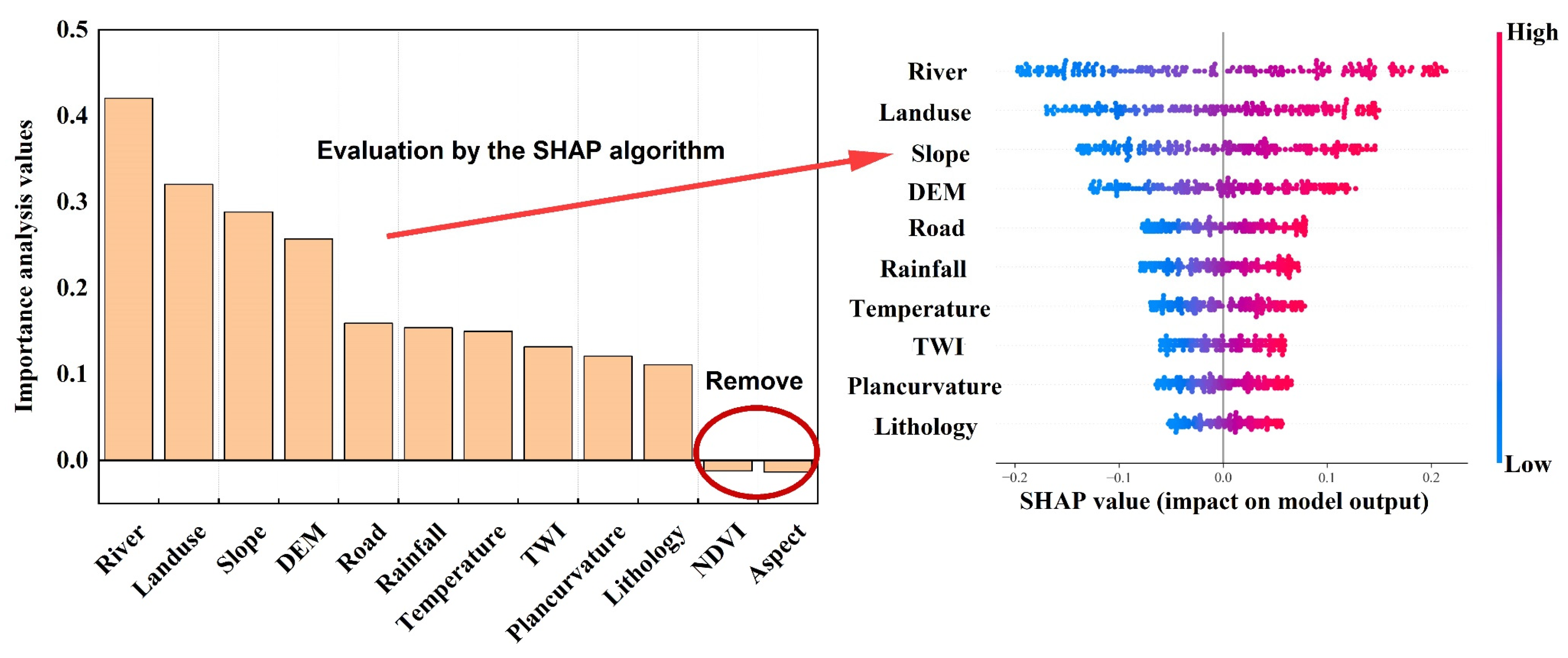
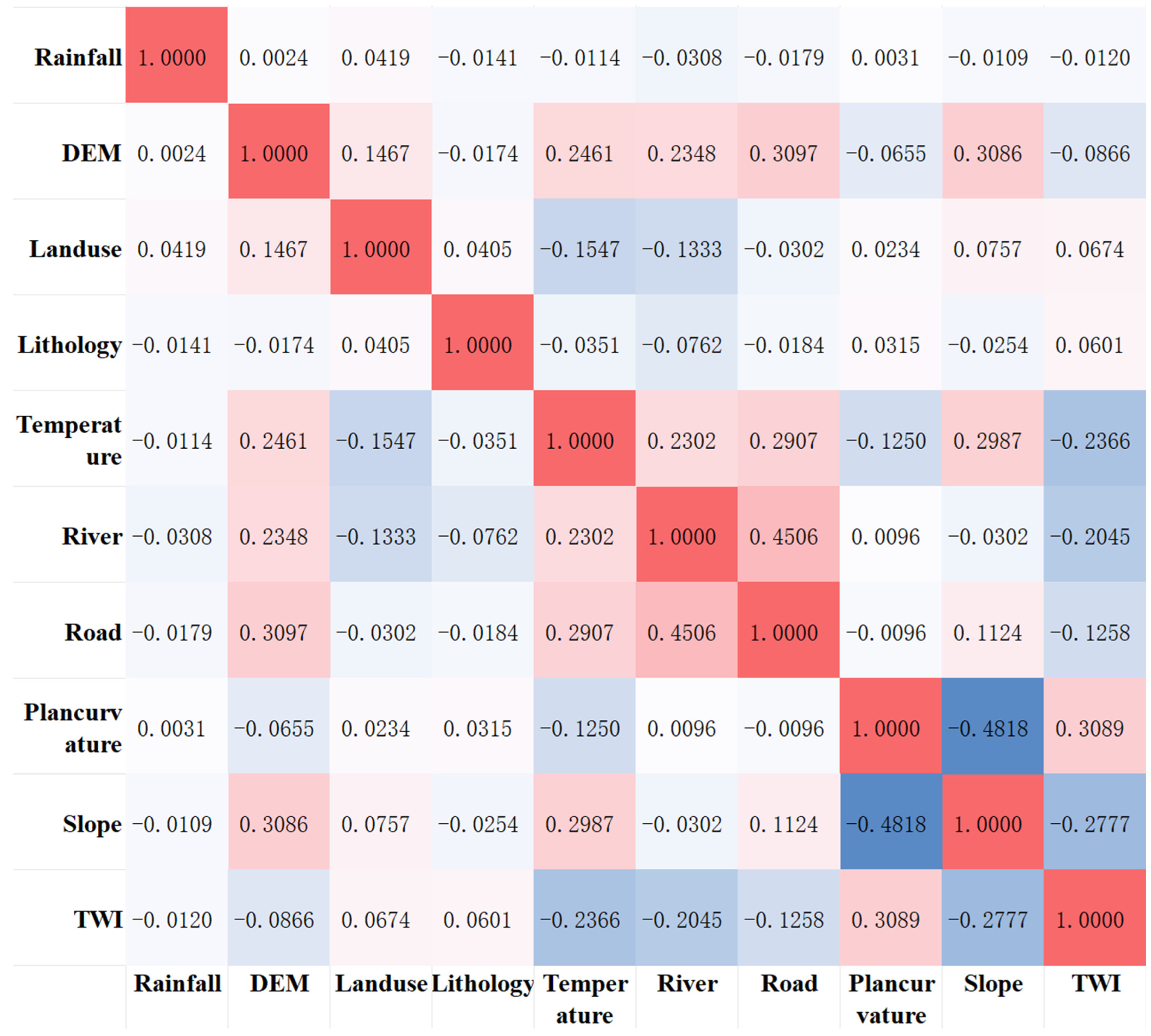
3.1. Importance and Correlation Analysis of Landslide Conditioning Factors
3.2. Comparison of Strategies for Non-Landslide Sampling
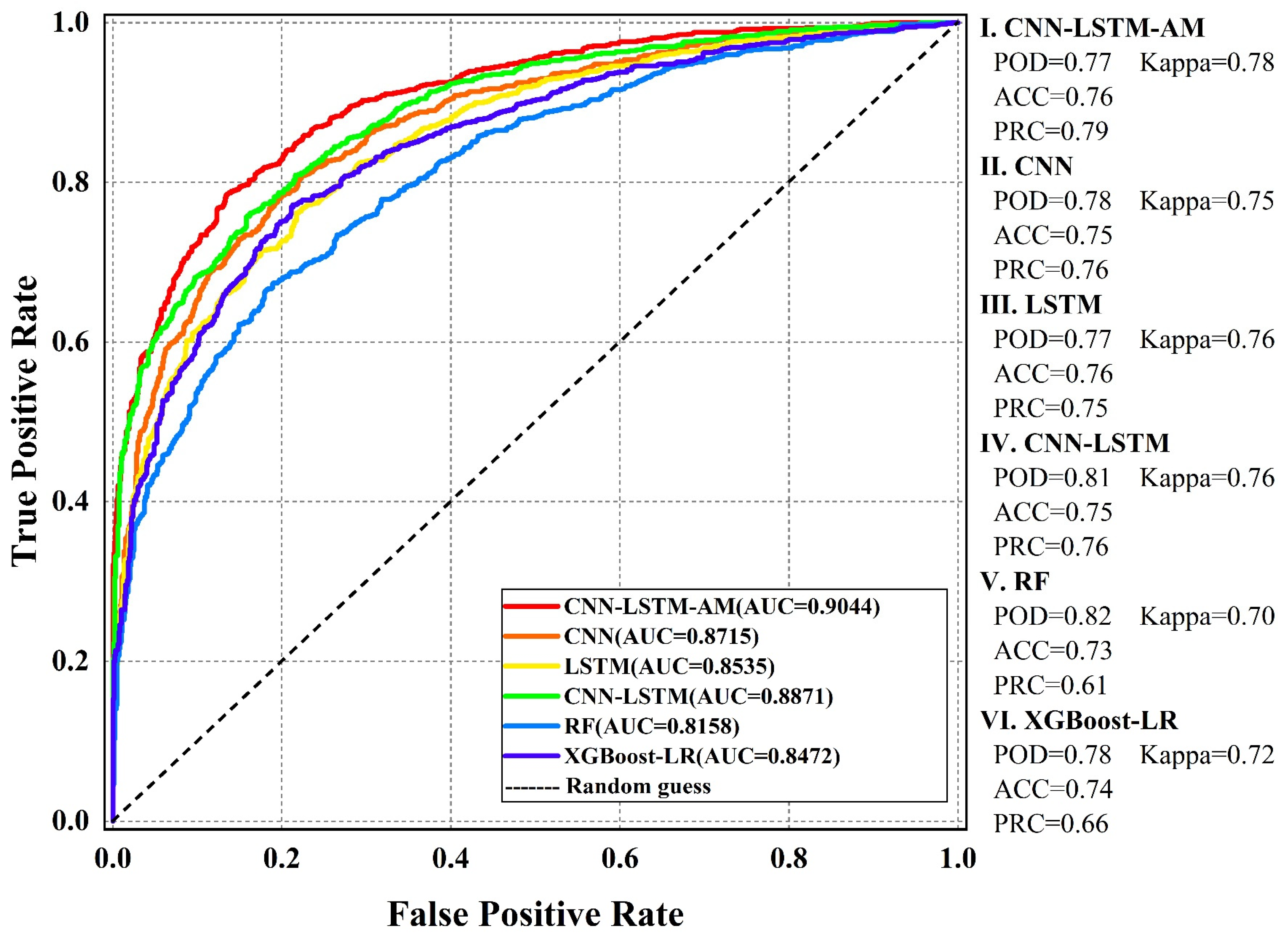
3.3. Model Performance
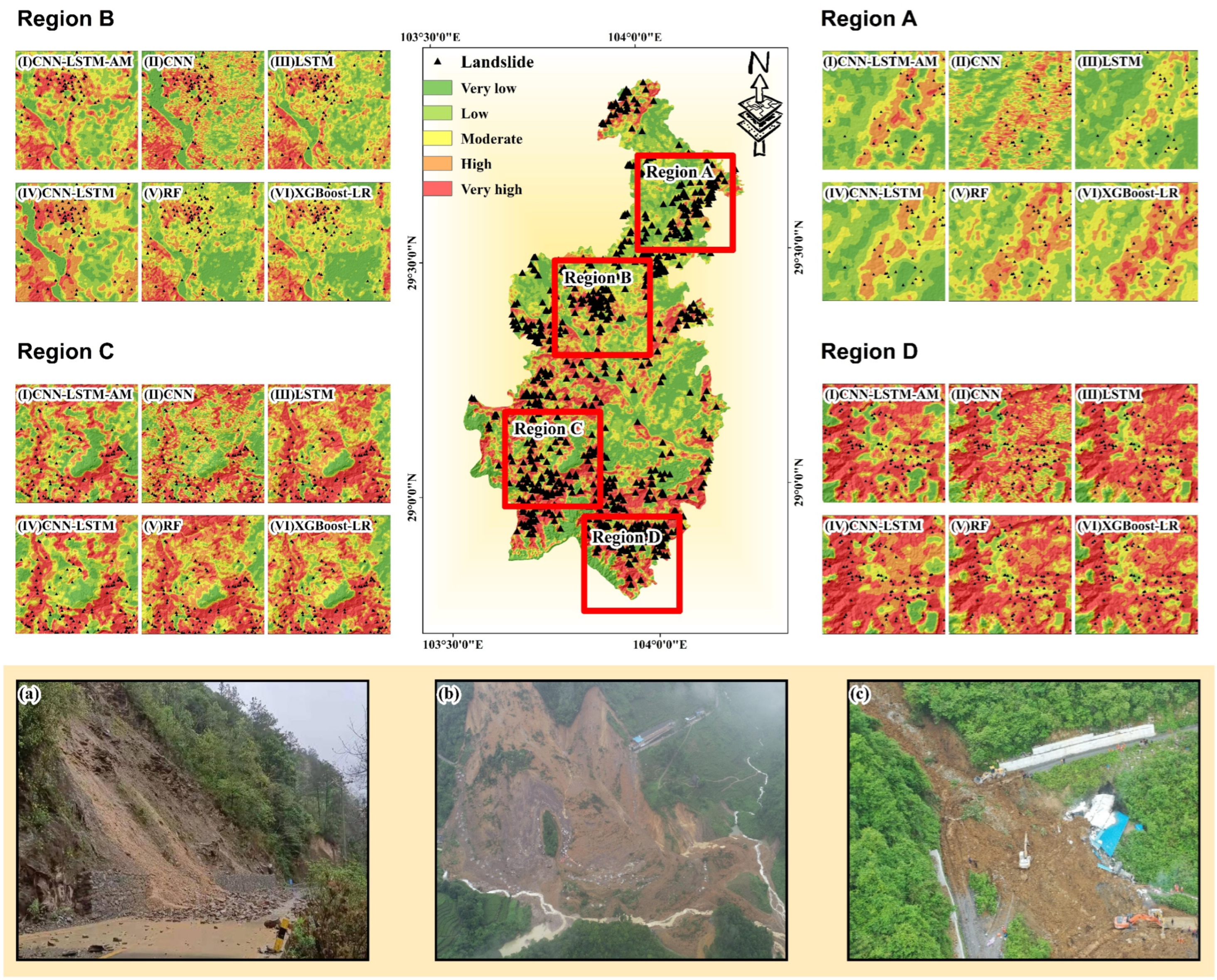
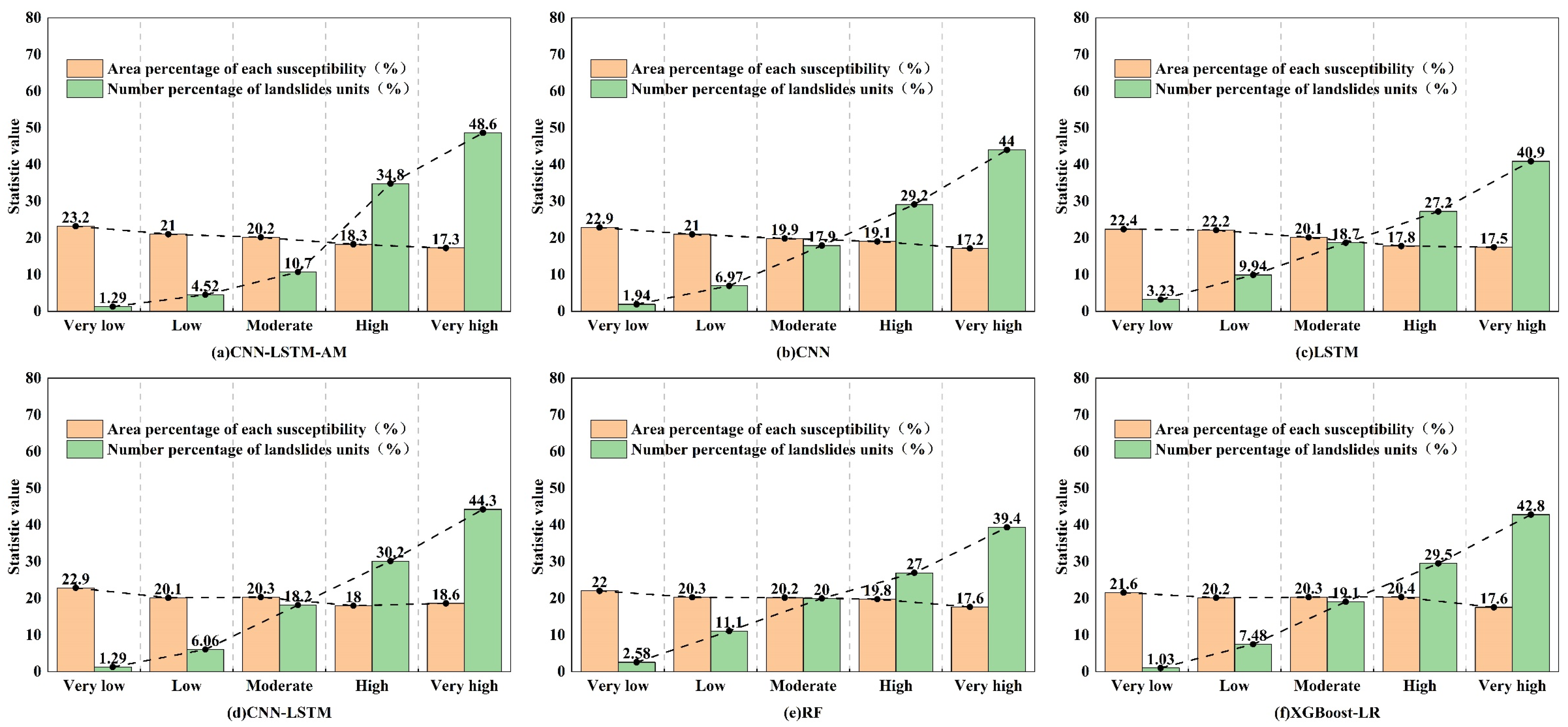
3.4. Comparison of Hazard Maps Under Different Models
4. Discussion
- (1)
- Reliance solely on monthly-average precipitation and temperature data presents significant limitations. Critically, monthly aggregation obscures transient hydrological triggers, such as short-duration heavy rainfall and seasonal wet–dry transitions, which are mechanistically critical for rainfall-induced shallow landslides. To rigorously validate the CNN-LSTM-AM model’s robustness, future iterations should integrate higher-resolution climate variables, including:
- ➢
- Sub-daily rainfall intensity (daily/hourly)
- ➢
- Extreme weather event chronologies (e.g., torrential rainfall and typhoon impacts)
- ➢
- Seasonal precipitation regimes (exemplified by Sichuan’s Meiyu/plum rain season)
- (2)
- Furthermore, integrating high-resolution monitoring data—such as InSAR and drone-derived datasets—enables real-time multiregional analysis essential for evaluating model robustness across diverse environments. Given the developed transportation infrastructure and high population density in northeastern Leshan, future research will prioritize regions with comparable anthropogenic influences. This approach validates the model’s applicability in areas facing elevated socioeconomic risks.
- (3)
- While this study primarily addresses rainfall-induced shallow landslides, it does not comprehensively evaluate other landslide types. Given the study area’s predominance of loose sediments, limited data exist on deep-seated rockslides, constraining the model’s applicability to diverse failure mechanisms. Future research will extend the framework to incorporate varied failure types, including rockslides and debris flows, and assess its robustness across heterogeneous geological settings to enhance transferability.
- (4)
- Time features are limited to monthly averages of rainfall and temperature; so, after concatenation, the temporal features’ contribution may be overshadowed by the spatial features (64- vs. 32-dimensional), negatively impacting fusion. Future research could optimize this by experimenting with different dimensional ratios, separate AM modules, or more temporal feature factors.
5. Conclusions
- (1)
- The non-landslide sampling strategy significantly affects model performance. Using the certainty factor model for pre-assessment and randomly sampling non-landslide points in low-risk areas after reclassification incorporates natural and human-made factors, yielding more reasonable features. This approach strengthens spatial constraints on non-landslide points, improving the dataset quality.
- (2)
- DL and its coupled models leverage multi-layer neural networks to learn hierarchical feature representations and fit complex nonlinear relationships. They outperform individual and traditional ML models in multimodal feature extraction and nonlinear modeling.
- (3)
- The CNN-LSTM-AM model integrates the spatial feature extraction capability of CNNs with the temporal sequence modeling strength of LSTMs, effectively fusing spatio-temporal characteristics. The AM further optimizes critical feature identification. Specifically, the LSTM’s gating mechanism regulates information flow to preserve essential temporal patterns, while the CNNs’ hierarchical structure mitigates overfitting by suppressing feature redundancy. The AM dynamically recalibrates feature weights to enhance extraction efficiency. This synergistic architecture significantly boosts feature mining and processing capabilities, particularly for rainfall-triggered shallow landslides prevalent in the study area, resulting in improved predictive performance.
Author Contributions
Funding
Data Availability Statement
Acknowledgments
Conflicts of Interest
References
- Chen, W.; Pourghasemi, H.R.; Panahi, M.; Kornejady, A.; Wang, J.; Xie, X.; Cao, S. Spatial prediction of landslide susceptibility using an adaptive neuro-fuzzy inference system combined with frequency ratio, generalized additive model, and support vector machine techniques. Geomorphology 2017, 297, 69–85. [Google Scholar] [CrossRef]
- Brenning, A. Spatial prediction models for landslide hazards: Review, comparison and evaluation. Nat. Hazards Earth Syst. Sci. 2005, 5, 853–862. [Google Scholar] [CrossRef]
- Reichenbach, P.; Rossi, M.; Malamud, B.D.; Mihir, M.; Guzzetti, F. A review of statistically-based landslide susceptibility models. Earth-Sci. Rev. 2018, 180, 60–91. [Google Scholar] [CrossRef]
- Chang, Z.; Du, Z.; Zhang, F.; Huang, F.; Chen, J.; Li, W.; Guo, Z. Landslide susceptibility prediction based on remote sensing images and GIS: Comparisons of supervised and unsupervised machine learning models. Remote Sens. 2020, 12, 502. [Google Scholar] [CrossRef]
- Barman, J.; Soren, D.D.L.; Biswas, B. Landslide susceptibility evaluation and analysis: A review on articles published during 2000 to 2020. In Monitoring and Managing Multi-Hazards—A Multidisciplinary Approach; Springer: Berlin/Heidelberg, Germany, 2022; pp. 211–220. [Google Scholar]
- Yin, K. Statistical prediction model for slope instability of metamorphosed rocks. In Proceedings of the 5th International Symposium on Landslides, Lausanne, Switzerland, 10–15 July 1988; pp. 1269–1272. [Google Scholar]
- Qiang, Y.; Gaofeng, W.; Weicui, D. Susceptibility and accuracy evaluation of regional landsldie based on multiple hybrid models. J. Nat. Disasters 2021, 30, 36–51. [Google Scholar]
- Wang, Y.; Wu, X.; Chen, Z.; Ren, F.; Feng, L.; Du, Q. Optimizing the predictive ability of machine learning methods for landslide susceptibility mapping using SMOTE for Lishui City in Zhejiang Province, China. Int. J. Environ. Res. Public Health 2019, 16, 368. [Google Scholar] [CrossRef]
- Youssef, A.M.; Pourghasemi, H.R.; Pourtaghi, Z.S.; Al-Katheeri, M.M. Landslide susceptibility mapping using random forest, boosted regression tree, classification and regression tree, and general linear models and comparison of their performance at Wadi Tayyah Basin, Asir Region, Saudi Arabia. Landslides 2016, 13, 839–856. [Google Scholar] [CrossRef]
- Chen, W.; Xie, X.; Wang, J.; Pradhan, B.; Hong, H.; Bui, D.T.; Duan, Z.; Ma, J. A comparative study of logistic model tree, random forest, and classification and regression tree models for spatial prediction of landslide susceptibility. Catena 2017, 151, 147–160. [Google Scholar] [CrossRef]
- Dang, V.-H.; Hoang, N.-D.; Nguyen, L.-M.-D.; Bui, D.T.; Samui, P. A novel GIS-based random forest machine algorithm for the spatial prediction of shallow landslide susceptibility. Forests 2020, 11, 118. [Google Scholar] [CrossRef]
- Yesilnacar, E.; Topal, T. Landslide susceptibility mapping: A comparison of logistic regression and neural networks methods in a medium scale study, Hendek region (Turkey). Eng. Geol. 2005, 79, 251–266. [Google Scholar] [CrossRef]
- Lu, Z.; Liu, G.; Song, Z.; Sun, K.; Li, M.; Chen, Y.; Zhao, X.; Zhang, W. Advancements in Technologies and Methodologies of Machine Learning in Landslide Susceptibility Research: Current Trends and Future Directions. Appl. Sci. 2024, 14, 9639. [Google Scholar] [CrossRef]
- Bui, D.T.; Hoang, N.-D.; Martínez-Álvarez, F.; Ngo, P.-T.T.; Hoa, P.V.; Pham, T.D.; Samui, P.; Costache, R. A novel deep learning neural network approach for predicting flash flood susceptibility: A case study at a high frequency tropical storm area. Sci. Total Environ. 2020, 701, 134413. [Google Scholar]
- Chen, Y.; Lin, Z.; Zhao, X.; Wang, G.; Gu, Y. Deep learning-based classification of hyperspectral data. IEEE J. Sel. Top. Appl. Earth Obs. Remote Sens. 2014, 7, 2094–2107. [Google Scholar] [CrossRef]
- Liu, Y.; Wu, L. Geological disaster recognition on optical remote sensing images using deep learning. Procedia Comput. Sci. 2016, 91, 566–575. [Google Scholar] [CrossRef]
- Huang, F.; Zhang, J.; Zhou, C.; Wang, Y.; Huang, J.; Zhu, L. A deep learning algorithm using a fully connected sparse autoencoder neural network for landslide susceptibility prediction. Landslides 2020, 17, 217–229. [Google Scholar] [CrossRef]
- Xiao, L.; Zhang, Y.; Peng, G. Landslide susceptibility assessment using integrated deep learning algorithm along the China-Nepal highway. Sensors 2018, 18, 4436. [Google Scholar] [CrossRef] [PubMed]
- Habumugisha, J.M.; Chen, N.; Rahman, M.; Islam, M.M.; Ahmad, H.; Elbeltagi, A.; Sharma, G.; Liza, S.N.; Dewan, A. Landslide susceptibility mapping with deep learning algorithms. Sustainability 2022, 14, 1734. [Google Scholar] [CrossRef]
- Cui, H.; Ji, J.; Hürlimann, M.; Medina, V. Probabilistic and physically-based modelling of rainfall-induced landslide susceptibility using integrated GIS-FORM algorithm. Landslides 2024, 21, 1461–1481. [Google Scholar] [CrossRef]
- Cui, H.; Tong, B.; Wang, T.; Dou, J.; Ji, J. A hybrid data-driven approach for rainfall-induced landslide susceptibility mapping: Physically-based probabilistic model with convolutional neural network. J. Rock Mech. Geotech. Eng. 2024. [Google Scholar] [CrossRef]
- Ji, J.; Cui, H.; Zhang, T.; Song, J.; Gao, Y. A GIS-based tool for probabilistic physical modelling and prediction of landslides: GIS-FORM landslide susceptibility analysis in seismic areas. Landslides 2022, 19, 2213–2231. [Google Scholar] [CrossRef]
- Cui, H.; Medina, V.; Hürlimann, M.; Ji, J. Fast physically-based probabilistic modelling of rainfall-induced shallow landslide susceptibility at the regional scale considering geotechnical uncertainties and different hydrological conditions. Comput. Geotech. 2024, 172, 106400. [Google Scholar] [CrossRef]
- Min, D.-H.; Yoon, H.-K. Suggestion for a new deterministic model coupled with machine learning techniques for landslide susceptibility mapping. Sci. Rep. 2021, 11, 6594. [Google Scholar] [CrossRef] [PubMed]
- Hu, X.; Mei, H.; Zhang, H.; Li, Y.; Li, M. Performance evaluation of ensemble learning techniques for landslide susceptibility mapping at the Jinping county, Southwest China. Nat. Hazards 2021, 105, 1663–1689. [Google Scholar] [CrossRef]
- Hu, X.; Zhang, H.; Mei, H.; Xiao, D.; Li, Y.; Li, M. Landslide susceptibility mapping using the stacking ensemble machine learning method in Lushui, Southwest China. Appl. Sci. 2020, 10, 4016. [Google Scholar] [CrossRef]
- Youssef, K.; Shao, K.; Moon, S.; Bouchard, L.-S. Landslide susceptibility modeling by interpretable neural network. Commun. Earth Environ. 2023, 4, 162. [Google Scholar] [CrossRef]
- Zhang, J.; Qian, J.; Lu, Y.; Li, X.; Song, Z. Study on Landslide Susceptibility Based on Multi-Model Coupling: A Case Study of Sichuan Province, China. Sustainability 2024, 16, 6803. [Google Scholar] [CrossRef]
- Azarafza, M.; Azarafza, M.; Akgün, H.; Atkinson, P.M.; Derakhshani, R. Deep learning-based landslide susceptibility mapping. Sci. Rep. 2021, 11, 24112. [Google Scholar] [CrossRef]
- Meena, S.R.; Puliero, S.; Bhuyan, K.; Floris, M.; Catani, F. Assessing the importance of conditioning factor selection in landslide susceptibility for the province of Belluno (region of Veneto, northeastern Italy). Nat. Hazards Earth Syst. Sci. 2022, 22, 1395–1417. [Google Scholar] [CrossRef]
- Moghimi, A.; Singha, C.; Fathi, M.; Pirasteh, S.; Mohammadzadeh, A.; Varshosaz, M.; Huang, J.; Li, H. Hybridizing genetic random forest and self-attention based CNN-LSTM algorithms for landslide susceptibility mapping in Darjiling and Kurseong, India. Quat. Sci. Adv. 2024, 14, 100187. [Google Scholar] [CrossRef]
- Kalantar, B.; Ueda, N.; Lay, U.S.; Al-Najjar, H.A.H.; Halin, A.A. Conditioning factors determination for landslide susceptibility mapping using support vector machine learning. In Proceedings of the IGARSS 2019—2019 IEEE International Geoscience and Remote Sensing Symposium, Yokohama, Japan, 28 July–2 August 2019; pp. 9626–9629. [Google Scholar]
- Jiang, W.; Li, L.; Niu, R. Impact of non-landslide sample sampling strategies and model selection on landslide susceptibility mapping. Appl. Sci. 2025, 15, 2132. [Google Scholar] [CrossRef]
- Xi, C.; Han, M.; Hu, X.; Liu, B.; He, K.; Luo, G.; Cao, X. Effectiveness of Newmark-based sampling strategy for coseismic landslide susceptibility mapping using deep learning, support vector machine, and logistic regression. Bull. Eng. Geol. Environ. 2022, 81, 174. [Google Scholar] [CrossRef]
- Okalp, K.; Akgün, H. Landslide susceptibility assessment in medium-scale: Case studies from the major drainage basins of Turkey. Environ. Earth Sci. 2022, 81, 244. [Google Scholar] [CrossRef]
- Gu, T.; Duan, P.; Wang, M.; Li, J.; Zhang, Y. Effects of non-landslide sampling strategies on machine learning models in landslide susceptibility mapping. Sci. Rep. 2024, 14, 7201. [Google Scholar] [CrossRef]
- Wei, M.; Dai, F.; Liu, Y.; Li, A.; Yan, Z. Influences of loading method and notch type on rock fracture toughness measurements: From the perspectives of T-stress and fracture process zone. Rock Mech. Rock Eng. 2021, 54, 4965–4986. [Google Scholar] [CrossRef]
- Xu, Y.; Dai, F. Dynamic response and failure mechanism of brittle rocks under combined compression-shear loading experiments. Rock Mech. Rock Eng. 2018, 51, 747–764. [Google Scholar] [CrossRef]
- Liu, Y.; Dai, F. A damage constitutive model for intermittent jointed rocks under cyclic uniaxial compression. Int. J. Rock Mech. Min. Sci. 2018, 103, 289–301. [Google Scholar] [CrossRef]
- Sun, D. Landslide Susceptibility Zoning and Rainfall-Induced Landslide Prediction and Early Warning Service Based on Machine Learning; East China Normal University: Shanghai, China, 2019. [Google Scholar]
- Yang Le, P.H.M.; Xie, H.; Luo, Z.; Tan, L. Assessment of Geological Environment Carrying Capacity of Fengjie County Based on AHP. J. Chongqing Jiaotong Univ. Nat. Sci. 2014, 33, 95–99. [Google Scholar]
- Arsyad, A.; Hamid, W. Landslide susceptibility mapping along road corridors in west Sulawesi using GIS-AHP models. In Proceedings of the IOP Conference Series: Earth and Environmental Science, Bali, Indonesia, 29–30 August 2019; p. 012080. [Google Scholar]
- Guo, J. Study on the influence of river erosion on landslide stability. Gansu Water Resour. Hydropower Technol. 2019, 55, 38–41. [Google Scholar]
- Niraj, K.; Singh, A.; Shukla, D.P. Effect of the normalized difference vegetation index (NDVI) on GIS-enabled bivariate and multivariate statistical models for landslide susceptibility mapping. J. Indian Soc. Remote Sens. 2023, 51, 1739–1756. [Google Scholar] [CrossRef]
- Chen, W.; Chai, H.; Zhao, Z.; Wang, Q.; Hong, H. Landslide susceptibility mapping based on GIS and support vector machine models for the Qianyang County, China. Environ. Earth Sci. 2016, 75, 474. [Google Scholar] [CrossRef]
- Dahal, R.K.; Hasegawa, S.; Nonomura, A.; Yamanaka, M.; Masuda, T.; Nishino, K. GIS-based weights-of-evidence modelling of rainfall-induced landslides in small catchments for landslide susceptibility mapping. Environ. Geol. 2008, 54, 311–324. [Google Scholar] [CrossRef]
- Gariano, S.L.; Guzzetti, F. Landslides in a changing climate. Earth-Sci. Rev. 2016, 162, 227–252. [Google Scholar] [CrossRef]
- Henriques, C.; Zêzere, J.L.; Marques, F. The role of the lithological setting on the landslide pattern and distribution. Eng. Geol. 2015, 189, 17–31. [Google Scholar] [CrossRef]
- China Geological Data Library. Available online: http://www.ngac.org.cn/ (accessed on 5 June 2024).
- Wang, Y.; Fang, Z.; Hong, H. Comparison of convolutional neural networks for landslide susceptibility mapping in Yanshan County, China. Sci. Total Environ. 2019, 666, 975–993. [Google Scholar] [CrossRef] [PubMed]
- Hamedi, H.; Alesheikh, A.A.; Panahi, M.; Lee, S. Landslide susceptibility mapping using deep learning models in Ardabil province, Iran. Stoch. Environ. Res. Risk Assess. 2022, 36, 4287–4310. [Google Scholar] [CrossRef]
- Zhang, D.; Yang, J.; Li, F.; Han, S.; Qin, L.; Li, Q. Landslide risk prediction model using an attention-based temporal convolutional network connected to a recurrent neural network. IEEE Access 2022, 10, 37635–37645. [Google Scholar] [CrossRef]
- Ge, Q.; Li, J.; Wang, X.; Deng, Y.; Zhang, K.; Sun, H. LiteTransNet: An interpretable approach for landslide displacement prediction using transformer model with attention mechanism. Eng. Geol. 2024, 331, 107446. [Google Scholar] [CrossRef]
- Kavzoglu, T.; Sahin, E.K.; Colkesen, I. Selecting optimal conditioning factors in shallow translational landslide susceptibility mapping using genetic algorithm. Eng. Geol. 2015, 192, 101–112. [Google Scholar] [CrossRef]
- Peng, M.; Zhang, L.; Sun, X.; Cen, Y.; Zhao, X. A fast three-dimensional convolutional neural network-based spatiotemporal fusion method (STF3DCNN) using a spatial-temporal-spectral dataset. Remote Sens. 2020, 12, 3888. [Google Scholar] [CrossRef]
- Liu, H.; Chen, W.; Li, Y. Application of integrated model based on EEMD-CNN-LSTM for landslide-displacement prediction. J. Geomech. 2024, 30, 633–646. [Google Scholar]
- Fan, W.; Wei, X.-s.; Cao, Y.-b.; Zheng, B. Landslide susceptibility assessment using the certainty factor and analytic hierarchy process. J. Mt. Sci. 2017, 14, 906–925. [Google Scholar] [CrossRef]
- Zhengjun, M.; Jing’e, Z.; Jiaxin, Z. Sensitivity analysis of factors influencing loess terrace landslide potential using certainty factor method. Bull. Soil Water Conserv. 2023, 43, 183–192. [Google Scholar]
- Dou, H.; He, J.; Huang, S.; Jian, W.; Guo, C. Influences of non-landslide sample selection strategies on landslide susceptibility mapping by machine learning. Geomat. Nat. Hazards Risk 2023, 14, 2285719. [Google Scholar] [CrossRef]
- Ercanoglu, M.; Gokceoglu, C.; Van Asch, T.W. Landslide susceptibility zoning north of Yenice (NW Turkey) by multivariate statistical techniques. Nat. Hazards 2004, 32, 1–23. [Google Scholar] [CrossRef]
- Hong, H.; Ilia, I.; Tsangaratos, P.; Chen, W.; Xu, C. A hybrid fuzzy weight of evidence method in landslide susceptibility analysis on the Wuyuan area, China. Geomorphology 2017, 290, 1–16. [Google Scholar] [CrossRef]
- Gomez, H.; Kavzoglu, T. Assessment of shallow landslide susceptibility using artificial neural networks in Jabonosa River Basin, Venezuela. Eng. Geol. 2005, 78, 11–27. [Google Scholar] [CrossRef]
- Kavzoglu, T.; Sahin, E.K.; Colkesen, I. Landslide susceptibility mapping using GIS-based multi-criteria decision analysis, support vector machines, and logistic regression. Landslides 2014, 11, 425–439. [Google Scholar] [CrossRef]
- Cantarino, I.; Carrion, M.A.; Goerlich, F.; Martinez Ibañez, V. A ROC analysis-based classification method for landslide susceptibility maps. Landslides 2019, 16, 265–282. [Google Scholar] [CrossRef]
- Sterlacchini, S.; Ballabio, C.; Blahut, J.; Masetti, M.; Sorichetta, A. Spatial agreement of predicted patterns in landslide susceptibility maps. Geomorphology 2011, 125, 51–61. [Google Scholar] [CrossRef]
- Kalantar, B.; Pradhan, B.; Naghibi, S.A.; Motevalli, A.; Mansor, S. Assessment of the effects of training data selection on the landslide susceptibility mapping: A comparison between support vector machine (SVM), logistic regression (LR) and artificial neural networks (ANN). Geomat. Nat. Hazards Risk 2018, 9, 49–69. [Google Scholar] [CrossRef]
- Zhang, J.; Ma, X.; Zhang, J.; Sun, D.; Zhou, X.; Mi, C.; Wen, H. Insights into geospatial heterogeneity of landslide susceptibility based on the SHAP-XGBoost model. J. Environ. Manag. 2023, 332, 117357. [Google Scholar] [CrossRef] [PubMed]
- Van den Broeck, G.; Lykov, A.; Schleich, M.; Suciu, D. On the tractability of SHAP explanations. J. Artif. Intell. Res. 2022, 74, 851–886. [Google Scholar] [CrossRef]
- Yang, X.; Liu, R.; Yang, M.; Chen, J.; Liu, T.; Yang, Y.; Chen, W.; Wang, Y. Incorporating landslide spatial information and correlated features among conditioning factors for landslide susceptibility mapping. Remote Sens. 2021, 13, 2166. [Google Scholar] [CrossRef]
- Yang, C.; Liu, L.-L.; Huang, F.; Huang, L.; Wang, X.-M. Machine learning-based landslide susceptibility assessment with optimized ratio of landslide to non-landslide samples. Gondwana Res. 2023, 123, 198–216. [Google Scholar] [CrossRef]


| Data | Source |
|---|---|
| DEM | Geospatial Data Cloud (http://www.gscloud.cn/) |
| Lithology | China National Digital Geological Map (Public Version at 1:200,000 Scale) Spatial Database |
| Road and River | Institute of Resource and Environmental Science and Data Center, Chinese Academy of Sciences (https://www.resdc.cn/) |
| NDVI | Institute of Resource and Environmental Science and Data Center, Chinese Academy of Sciences (https://www.resdc.cn/) |
| Monthly average rainfall and temperature | National Qinghai-Tibet Plateau Data Center (https://data.tpdc.ac.cn/) |
| Zone Code | Stratigraphic Description | Lithological Features |
|---|---|---|
| I | Igneous rock | Contains pyroxene, plagioclase, feldspar, and mica. |
| II | Sedimentary rock | Clastic sedimentary rocks and chemical sedimentary rocks often contain quartz, clay, fossils, and mineral components, with distinct layered structures. |
| II | Tertiary rock | Loose alluvial deposits and accumulations, mainly composed of sand, gravel, clay, etc., often accompanied by organic matter and minerals. |
| IV | Quaternary sedimentary rocks | Alluvial deposits and wind-blown sand deposits containing gravel and clay, with loose sedimentary structures and distinct bedding planes. |
| V | Contemporary rock strata groups | Sandstone, shale, limestone, conglomerate, igneous rock, and other clastic or chemical sedimentary rocks. |
| VI | Constructive plane | Fracture zones, slip zones, contact surfaces, possible contact between igneous and sedimentary rocks, and rock layer fractures and displacements. |
| VII | Special stratigraphic unit | Specific biota or mineral-rich layers containing special sediments, such as lake sediments and tidal sediments. |
| Hyperparameter | Optimization Interval | Optimal Hyperparameters |
|---|---|---|
| Convolution filter | [16,128] | 16 |
| CNN layer learning rate | [0.0001,0.01] | 0.01 |
| L2 regularization parameter | [0.1,0.5] | 0.1 |
| CNN layer dropout rate | [0.1,0.5] | 0.01 |
| Activation function | [‘relu’, ‘tanh’, ‘sigmoid’] | tanh |
| Number of LSTM units | [32,256] | 32 |
| Number of LSTM layers | [1,3] | 3 |
| LSTM layer dropout rate | [0.1,0.5] | 0.21662988253928206 |
| DEM | CF | TWI | CF |
|---|---|---|---|
| 125–462 | −0.14 | 1.29–6.57 | 0.17 |
| 462–638 | 0.35 | 6.57–9.02 | 0.04 |
| 638–884 | 0.22 | 9.02–12.23 | −0.43 |
| 884–1210 | −0.50 | 12.23–16.18 | −0.60 |
| 1210–1908 | −0.52 | 16.18–25.42 | −0.61 |
| Road | CF | Slope | CF |
| 0–400 | 0.36 | 0−6.53 | −0.51 |
| 400–600 | 0.23 | 6.53–12.98 | 0.25 |
| 600–800 | 0.03 | 12.98–21.14 | 0.31 |
| 800–1500 | −0.12 | 21.14–32.56 | 0.28 |
| >1500 | −0.44 | 32.56–82.94 | 0.09 |
| River | CF | Plan curvature | CF |
| 0–100 | −0.70 | 0–16 | 0.27 |
| 100–300 | 0.61 | 16–28 | 0.08 |
| 300–800 | 0.14 | 28–41 | 0.02 |
| 800–1500 | 0.14 | 41–56 | −0.29 |
| >1500 | −0.52 | 56–76 | −0.49 |
| Lithology | CF | Land use | CF |
| I | −0.08 | L1 | 0.12 |
| II | −0.10 | L2 | −0.19 |
| III | 0.23 | L3 | −1.00 |
| IV | 0.06 | L4 | −1.00 |
| V | −0.14 | L5 | −0.92 |
| VI | 0.15 | L6 | −0.46 |
| VII | 0.16 |
| Landslide Conditioning Factor | E | Normalized Weight Values |
|---|---|---|
| DEM | 0.87 | 0.13 |
| TWI | 0.78 | 0.11 |
| Road | 0.80 | 0.12 |
| Slope | 0.82 | 0.12 |
| River | 1.31 | 0.19 |
| Plan curvature | 0.76 | 0.11 |
| Lithology | 0.37 | 0.05 |
| Land use | 1.12 | 0.16 |
| Strategy | MSE | AUC |
|---|---|---|
| (a) | 0.121 | 0.83 |
| (b) | 0.065 | 0.89 |
| (c) | 0.057 | 0.91 |
Disclaimer/Publisher’s Note: The statements, opinions and data contained in all publications are solely those of the individual author(s) and contributor(s) and not of MDPI and/or the editor(s). MDPI and/or the editor(s) disclaim responsibility for any injury to people or property resulting from any ideas, methods, instructions or products referred to in the content. |
© 2025 by the authors. Licensee MDPI, Basel, Switzerland. This article is an open access article distributed under the terms and conditions of the Creative Commons Attribution (CC BY) license (https://creativecommons.org/licenses/by/4.0/).
Share and Cite
Deng, J.-H.; Guo, H.-Y.; Cui, H.-Z.; Ji, J. Optimizing Landslide Susceptibility Mapping with Non-Landslide Sampling Strategy and Spatio-Temporal Fusion Models. Water 2025, 17, 1778. https://doi.org/10.3390/w17121778
Deng J-H, Guo H-Y, Cui H-Z, Ji J. Optimizing Landslide Susceptibility Mapping with Non-Landslide Sampling Strategy and Spatio-Temporal Fusion Models. Water. 2025; 17(12):1778. https://doi.org/10.3390/w17121778
Chicago/Turabian StyleDeng, Jun-Han, Hui-Ying Guo, Hong-Zhi Cui, and Jian Ji. 2025. "Optimizing Landslide Susceptibility Mapping with Non-Landslide Sampling Strategy and Spatio-Temporal Fusion Models" Water 17, no. 12: 1778. https://doi.org/10.3390/w17121778
APA StyleDeng, J.-H., Guo, H.-Y., Cui, H.-Z., & Ji, J. (2025). Optimizing Landslide Susceptibility Mapping with Non-Landslide Sampling Strategy and Spatio-Temporal Fusion Models. Water, 17(12), 1778. https://doi.org/10.3390/w17121778