1. Introduction
The cryosphere constitutes a vital component of the Earth’s system. With the sustained advancement and development of each research direction in the field of cryosphere, Cryospheric Science has emerged [
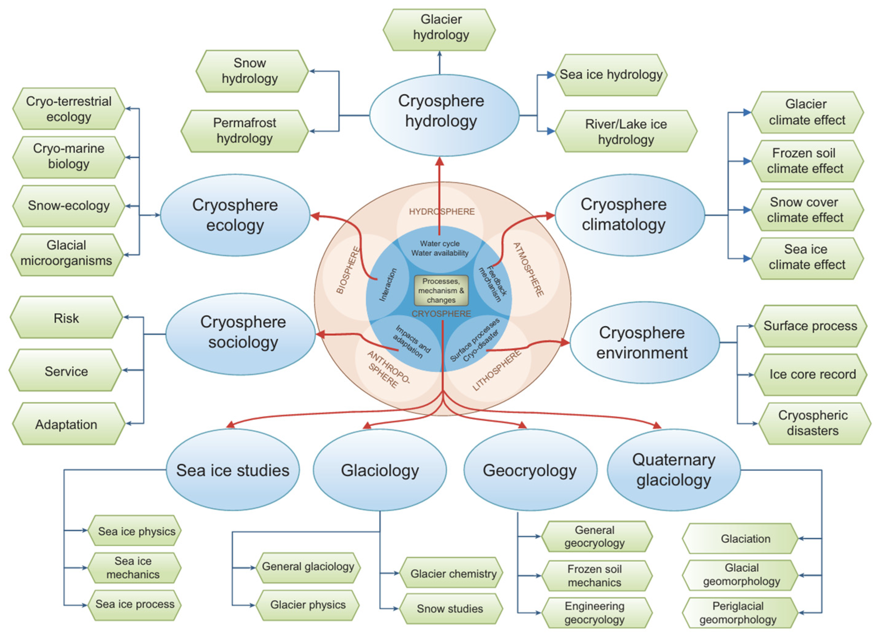
1]. The cryosphere covers snow, glaciers, river ice, lake ice, sea ice, permafrost, etc. These cryospheric elements are also present in the terrestrial spheres, resulting in the strong association of the cryosphere with these terrestrial spheres (the atmosphere, hydrosphere, lithosphere, biosphere) and the anthroposphere, as illustrated in
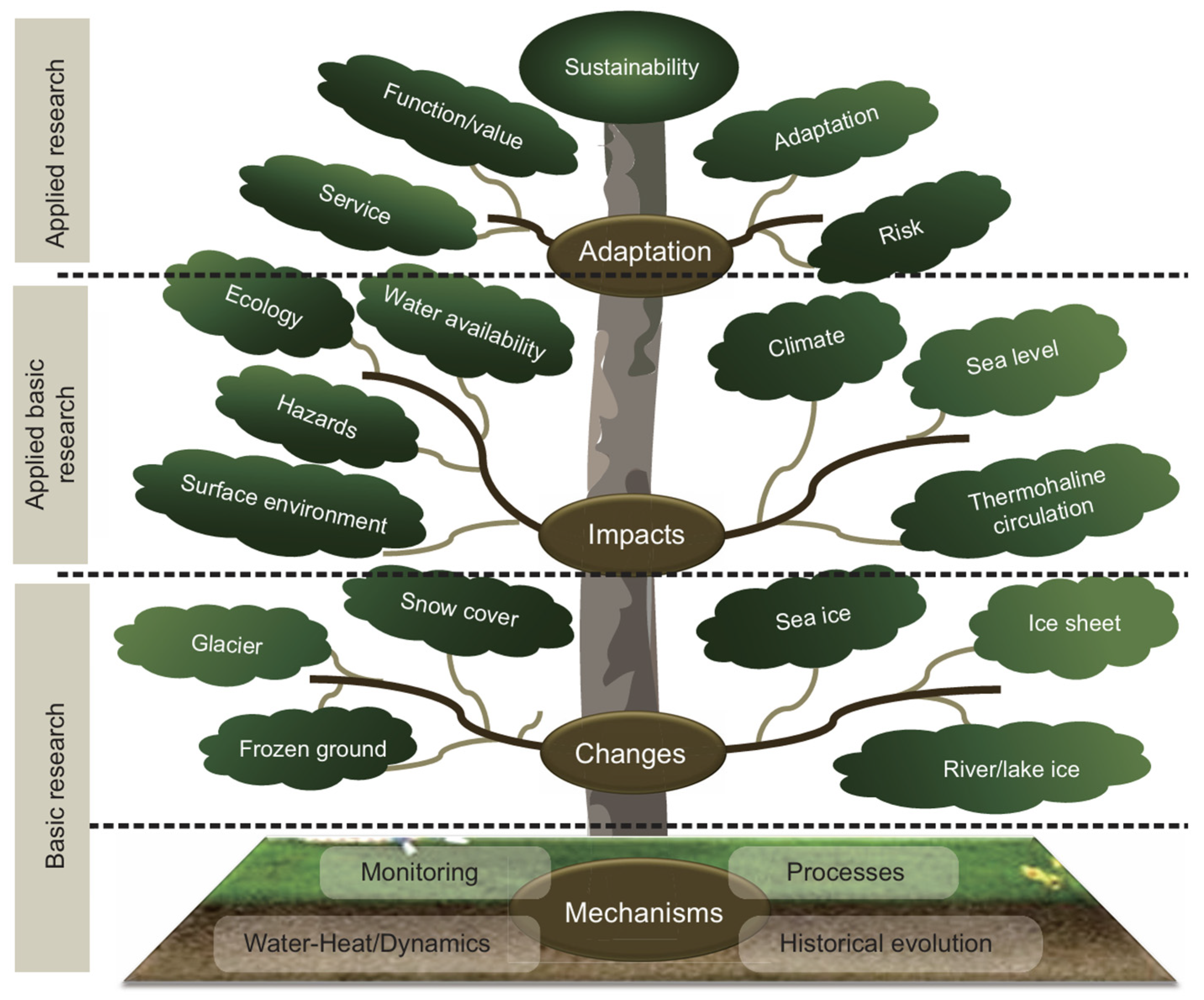
Figure 1. Therefore, there are macroscale geographical, scientific studies, and microscale applied basic scientific studies. Because it is relevant to both socioeconomic and ecological disciplines, Cryospheric Science has a tripartite research classification: basic research, applied basic research, and applied research; see
Figure 2 [
1].
On the geographical scale, glaciers, lakes/rivers, and oceans have distinct socio-ecological functions and systems [
2]. Notably, glaciers are situated in areas with limited anthropogenic disturbance. When they are conceptualized as an abiotic environmental driver, glaciers modulate downstream moraine ecosystems, river ecosystems, lake ecosystems, and estuary ecosystems [
3]. At present, from alpine glaciers to sea ice, these cryospheric components vary with global climate change. The fundamental consequences of cryospheric components are as follows: (1) Glaciers, functioning as solid water towers, are critically linked to human livelihoods. Glacial meltwater accounts for approximately a third of global river runoff, serving as a vital water source for arid regions. However, they are retreating at accelerated rates [
4]. (2) Phenological studies document a reduction in the ice-cover period in northern temperate lakes. (3) Phenological indicators of river ice in the Northern Hemisphere exhibit later freeze-up and earlier break-up dates, cover a smaller ice-covered area and have thinner ice thickness. (4) The spatial coverage and thickness of sea ice are decreasing, especially in the Arctic Ocean. Thinner winter ice accelerates summer ice melting, creating a self-reinforcing cycle. Ice-free ocean areas absorb greater solar radiation, delaying the autumn sea ice freeze-up date. Concurrently, diminished sea ice concentration around Antarctica enhances heat transfer from the ocean to the atmosphere, intensifying storm frequency. As sea ice melts, increased surface evaporation elevates atmospheric moisture, promoting low cloud formation. These low clouds absorb long-wave radiation from the ocean surface while retaining their heat function, prolonging the melting time of the sea ice while accelerating further ice loss.
On the applied basic science scale, cryospheric changes significantly impact human production and livelihoods through the following mechanisms. (1) While increased glacial meltwater may temporarily support agricultural irrigation and hydropower development, it poses latent risks to water scarcity in the long term. Meanwhile, increased glacier meltwater also elevates the probability of glacial lake outburst floods (GLOFs), threatening downstream infrastructure and human safety [
5]. (2) A complex coupled relationship exists between melting glaciers, imbalanced water resources, surface vegetation, desertification, and dust storms. In principle, this relationship is as follows: glacial retreat → reduced river/lake discharge → vegetation degradation → surface exposure → intensified dust storms [
6]. Particularly, soil erosion and desertification driven by overgrazing have become the focus of recent studies [
7,
8]. Notably, dust and black carbon on snow and ice surfaces accelerate ice melt via albedo reduction [
9]. (3) A reduced ice-cover period and ice thickness in lakes/rivers elevate water temperatures, triggering algal blooms and dissolved oxygen consumption. Concurrently, ice-dependent human activities and ecosystems are constrained for the following reasons: a reduced utilization period for seasonal “ice roads”, which are critical winter transportation corridors in high-latitude regions; the disruption of irrigation scheduling; the curtailment of ice tourism activities [
10]; shortened winter fishing durations; and alterations in fish spawning habitats [
11]. (4) Arctic sea ice loss modifies hemispheric barometric pressure and temperature differentials, increasing the frequency of cold waves, storms, and precipitation extremes [
12]. In contrast, it increases the possibility of Arctic navigation. Antarctic ecosystem stability is jeopardized by the Southern Ocean Sea ice, which is in decline.
This Special Issue aims to publish comprehensive reviews, recent research, and forward-looking recommendations on ice studies spanning alpine to marine systems. By integrating research on glacial, river ice, lake ice, and sea ice, we aim to reflect the research progress made in different regions within terrestrial–marine hydroecological systems. This issue specifically investigates natural snow/ice–human interactions and explores challenges and adaptation strategies under climate change. The scope of contributions encompasses but is not limited to, physical, thermal, mechanical, optical, and electrical properties of snow and ice, alongside their multidisciplinary applications. Theoretical and practical advancements are made in remote sensing, field investigations, experimental studies, and the numerical modeling of cryospheric evolution processes. Cryospheric behaviors and their contributions to ecological and engineered systems are also explored.
3. An Overview of the Published Articles
Catchment areas for rivers and lakes are important links in the terrestrial–marine hydroecological system. Lake ice exerts multifaceted impacts across natural systems and socioeconomic domains, influencing lake ecosystem functionality, human activities with associated safety considerations, regional climatic patterns, the economy, etc. [
13]. The presence of snow and ice regulates mass and energy exchange processes at the air–water interface, thereby modifying critical ecological parameters, including optical characteristics, temperature, hydrodynamic circulation regimes, and dissolved gas concentrations. Furthermore, the lake ice cover acts as an ecological modulator by altering environmental determinants governing aquatic organisms [
14]. Despite growing scientific attention to winter limnology, the current understanding of shifts in climate-driven ice phenology is constrained by spatially limited observational datasets, with comprehensive analyses available for only a small fraction of global lakes. There are still many lakes in other regions that are waiting to be studied. There is significant potential for research on lake ice changes associated with global warming, particularly in three key domains: lake ice phenology, ice thickness variability, and snow/ice ratios. The research objectives in lake ice phenology focus on three critical temporal parameters: the ice formation date, ice melting date, and ice-covered duration. Through long-term observational programs, comprehensive multi-year records of ice phenology have been completed in lake systems around the world. Recent analyses have yielded significant evidence establishing the linkages between climatic mechanisms and lake ice phenology alterations [
15]. Concurrently, the advent of remote sensing technologies has revolutionized data acquisition capacities, enabling the systematic monitoring of ice phenology parameters across extensive territories that were previously logistically constrained [
16]. This technological synergy between satellite-based observations and in situ measurements has revealed several patterns of change in lake ice, and these patterns contain information related to local hydrometeorological and geographical features [
17]. Lake ice formation encompasses two distinct growth mechanisms [
18]. Frozen water ice, commonly termed “black ice”, develops through downward freezing at the ice–water interface. Conversely, superimposed ice (“white ice”) originates from the freezing of slush layers atop existing ice, where slush formation occurs from the refreezing of snow mixed with lake water, meltwater, or rain. The prerequisites for these ice types exhibit differences. While cold air (with the temperature below the freezing point) constitutes the essential condition for basal lake ice growth, white ice formation additionally requires snow accumulation exceeding a third of the total ice thickness. This different climatic dependency governs their spatial distribution: temperate lacustrine systems typically contain black ice and white ice [
18,
19], whereas arid-region lakes predominantly develop black ice due to insufficient snowfall [
20]. Mechanical property analyses reveal that black ice possesses a greater bearing capacity than white ice [
21,
22]. Optically, white ice has less transmissivity compared to black ice [
23]. These optical differences drive critical limnological consequences: increased white ice thickness alters underwater irradiance regimes, subsequently affecting underwater biological processes (the development of phytoplankton) and heat exchange processes [
14,
22].
Contribution [4] collected lake ice studies in different regions of Eurasia to address the problem of black ice and white ice in the Northern Hemisphere. Arctic zone: Lake Imandra in Murmansk Oblast, Russia, and Lake Kilpisjärvi in Finland. High-altitude zone: Lake Arpi and Lake Sevan in Armenia. Temperate zone: Six lakes in Karelia, Russia, Mozhaysk Reservoir in Moscow, Oblast, Russia, and Lake Pääjärvi in Finland. Central Asian arid zone: Lake Ulansuhai in Inner Mongolia, China. The primary objective focused on recognizing patterns of change in lake ice within the context of regional climatic fluctuations. Investigations into ice composition necessitated on-site measurements, rendering ice structure analyses particularly challenging regarding remote or inaccessible lake environments. This operational constraint highlights the imperative to refine modeling approaches in order to estimate white and black ice thickness based on weather data [
24]. The successful implementation of such approaches demands the integration of surface energy balance constituents, specifically temperature, solar radiation, cloudiness, snow thickness on ice, and wind. Contemporary detection techniques, such as unmanned aerial vehicles (UAVs) equipped with ground-penetrating radar (GPR), enable the spatial quantification of ice thickness and composition to determine the proportion of white ice and black ice. The Global Lake Ecological Observatory Network (GLEON), which supports lake ice research, was also presented. The observatory network conducted multiple measurements across 31 lakes in the Northern Hemisphere during the 2020–2021 winter, systematically recording the total ice thickness and white ice and black ice thickness. The results demonstrated an increase in the proportion of white ice throughout the freezing season for most lakes. Climate warming has significantly reduced black ice thickness, while white ice thickness exhibits regional divergence: the northern temperate and Arctic zones show enhanced white ice thickness, contrasting with southern temperate zones where frequent melt events and elevated precipitation suppress its development. In high-altitude and arid regions, limited snowfall/rainfall minimally contributes to the production of white ice.
The formation and melting of lake ice are closely related to the heat exchange processes with water bodies under the ice. While one-dimensional thermodynamic models adequately characterize these interactions in large lakes, their application to smaller lacustrine systems presents methodological limitations.
Contribution [1] conducted numerical simulations of radiatively driven convection (RDC) in a small ice-covered lacustrine system with a lateral pressure gradient. This study elucidated RDC’s ecological significance through its role in the transport of thermal energy, dissolved matter, and suspended particles based on the water column. Furthermore, there is a hypothesis that a continuum of convective cells exists within the convective mixed layer (CML), characterized by areas of ascending and descending water flows. Up until now, studies on the evolution of the CML under lateral transport conditions in lacustrine systems have been poor. This study employs an implicit large eddy simulation framework to reconstruct the multi-day evolution of the CML within a computational domain subject to lateral pressure gradients.
Free convection in lakes arises from gravitational instabilities induced by uneven density distributions within the water. This physical phenomenon is governed by the nonlinear dependence of water density on temperature and depth (pressure), particularly influenced by the temperature of maximum density (
Tmd) [
25]. The initiation and sustenance of these convective processes in lakes arise from multiple interactive mechanisms, including surface cooling [
26,
27], radiative heating [
28], thermobaric instabilities [
29], and other processes such as bioturbation, shear-driven convection, double diffusion, and river dynamics [
25]. In seasonally ice-covered lakes, RDC exerts significant biological and physical influences. Convection facilitates nutrient transport to the photic zone while redistributing algal cells through the water column, thereby modulating the development of the plankton community and metabolic processes [
30].
Numerical simulations comparing small ice-covered lakes with and without lateral pressure gradients revealed distinct CML conditions. Under zero pressure gradient conditions, CML exhibited multiple convective cells. When a pressure gradient was present, even a minor lateral pressure gradient resulted in structural change in convective cells, demonstrating the importance of lateral pressure gradients in the formation of the CML structure. As the lateral pressure gradients increased, the horizontal flow velocities increased, and the CML changed.
As a solid medium, river ice exerts substantial influence on channel evolution by changing hydrodynamic conditions and collisions, thus influencing hydraulic engineering design parameters. The presence of ice cover induces significant alterations to flow velocity profiles compared to open-channel conditions. This hydrodynamic transformation drives distinct sediment transport processes that reshape river channel morphology, such as the Inner Mongolia section of the Yellow River [
31]. Additionally, hydraulic structures and bridges constructed in the river channel change the boundary and flow conditions of the river. Previous studies have focused on exploring ice-induced changes in the flow field [
32] and the more complex phenomenon of sediment movement due to structures [
33].
Rivers serve as critical hydrological connectors between lacustrine and marine systems. In cold regions, although rivers maintain flow during winter, river ice formation remains prevalent under low-temperature conditions. In general, river ice formation is a highly complex system governed by the combined action of hydrodynamic, thermodynamic, and channel topographic conditions [
34]. Contemporary river ice models have predominantly evolved from these foundational theories. However, parametric uncertainties persist as a critical challenge within existing models [
35]. This limitation becomes particularly pronounced when analyzing ice jam/dam formation mechanisms under the combined influence of hydrodynamics, topography, and structures. These river ice phenomena that may cause disasters depend on the morphological characteristics of ice–water and water–riverbed interfaces. The quantitative index comprises the roughness coefficients that account for the roughness corresponding to the bottom surface of the ice layer during different ice growth periods; the roughness corresponding to the flow resistance caused by the riverbed pattern during different ice growth periods; the roughness corresponding to the localized flow resistance caused by the flow field alteration near artificial structures. While straightforward in principle, these parameters are complex in practice. They are closely related to ice conditions determined by local meteorological conditions, and sediment transport and siltation under the combined influence of local riverbed geologic conditions and hydrological conditions. Furthermore, these may affect the stability of the ice structures.
Contribution [5] presents a systematic review elucidating the interactions among river ice, channel morphology, and hydraulic structures. This paper discusses recent advancements in ice research, particularly the increase in channel roughness caused by ice jams/dams. Comparative studies demonstrate that ice-covered channels exhibit up to 50% greater composite roughness than their ice-free channels, driving flow field reorganization. This alteration in roughness leads to high flow velocities in the middle of the velocity distribution while shifting shear stress downward, exceeding critical thresholds for sediment-moving occurrence. Subsequent reviews of field observations, experimental studies, and numerical simulations reveal existing problems, including future research directions. The three main conclusions and suggestions are as follows: (1) The composite roughness of the ice-covered channel is an important indicator that reflects the capacity to transport water. While many formulas exist for estimating the composite roughness of river channels during freeze-up periods, which apply to some hydraulic conditions, there are still issues that require continued scientific research. For example, the calculation of composite roughness mainly relies on surface roughness under ice cover, but there is the infeasibility of direct measurements in field tests. While indirect methods for estimating ice-bottom roughness based on flow field distribution exist, the dynamic evolution of ice jams/dams induces unsteady flow fields that fundamentally constrain the accuracy of such methods. Experimental studies and numerical simulations have been used to determine the composite roughness of river channels under different conditions. The development of field observations is still needed. (2) The evolution of riverbeds during the winter has already been the subject of preliminary conclusions reached by field observation, experimental study, and numerical simulation. These include understanding the relationship between ice jam evolution and riverbed deformation, the influence of ice jam roughness on sediment incipient motion, the relationship between the maximum sediment transport rate and water velocity under ice cover, etc. The interaction mechanism between riverbed evolution and ice jam evolution in winter is complex. Different types of local scouring occur simultaneously. (3) The problem of local scouring around hydraulic structures under ice-covered conditions is a complex research field involving multi-factor coupling. As evidenced by existing studies, the presence of hydraulic infrastructure alters the surrounding flow field, particularly increased scouring near bridge piers. Nevertheless, systematic theoretical studies and numerical simulations elucidating the scouring effect around bridge piers during ice periods remain underdeveloped.
Sea ice, formed through seawater freezing, differs from river/lake ice both macroscopically in salinity and microscopically in crystalline structure and composition. Freshwater ice on rivers and lakes comprises three phases: pure ice crystals, unfrozen water, and gas bubbles. In contrast, sea ice consists of ice crystals, brine, and gas bubbles. The alteration from freshwater to brine leads to differences in freezing temperatures and the response of ice crystal types to external forces. Crystalline structure analysis reveals the simple crystalline structure of freshwater ice, while sea ice, due to refreezing processes, has up to nine types of crystalline structures [
36], differing in size, shape, and orientation of the crystals.
Porosity in freshwater ice and sea ice is defined as the volumetric fraction occupied by non-crystalline components: unfrozen water/brine and gas. In terms of materials, porosity serves as a critical assessment indicator of internal defects, thereby governing various properties of ice. In the 1980s, the influence of air bubbles on ice properties was generally considered negligible due to the low temperature of sea ice. Consequently, researchers predominantly utilized brine volume fraction determined by ice temperature and salinity as a proxy for porosity to quantify its effects on ice properties, particularly the relationship between brine content and mechanical properties. The advent of global warming has elevated ice temperatures, necessitating the incorporation of bubble volume into porosity calculations. Current methods calculate total porosity (the sum of brine volume and bubble volume) by combining ice temperature, salinity, and density. This shift requires substituting the brine volume fraction with total porosity when investigating the evolution of sea ice properties. These properties include uniaxial compressive strength [
37,
38], thermal diffusivity [
39], dielectric permittivity [
40], optical properties [
40,
41], and acoustic properties [
40]. The growing significance of bubble volume in influencing other properties of ice establishes ice density as an essential parameter. Meanwhile, the fundamental questions regarding the composition and provenance of these gases need to be addressed. While bubbles in freshwater ice typically exhibit near-spherical shapes, bubbles in sea ice exhibit a pronounced polymorphic shape [
42]. Such morphological diversity suggests more complex formation mechanisms in sea ice compared to freshwater ice.
Contribution [2] systematically investigated the potential mechanisms governing bubble formation in sea ice, including the release of air dissolved in seawater during crystallization; the replacement of heavy brine flowing down with atmospheric air; and the release of gas bubbles from the seabed sediments. This study developed a computational model to simulate the transport of gas bubbles from release to ice–water interfaces. The simulation results provide novel insights to explain the strength reduction in sea ice due to the increase in bubble volume. Furthermore, it also provides the foundation for finding near-bottom sources of natural gas by considering ice porosity characteristics, as well as discussing future research directions.
Sea ice imposes constraints on human activities in ice-covered marine regions. However, the accelerated retreat of Arctic Sea ice under global warming has been extensively documented. The Arctic Ocean’s vast natural resources stimulate growing interest in maritime operations, including commercial shipping trajectories, fishing, offshore resource extraction, and other marine activities. Accelerated sea ice retreat under climate warming mechanisms has contributed to the northward expansion of human activity areas. Contemporary Arctic marine engineering predominantly concentrates on two domains: Arctic shipping routes and ships and ice–structure interaction mechanics. These priorities have stimulated advancements in multiple research areas: integrated satellite–airborne–terrestrial observation systems for sea ice monitoring, the physical and mechanical properties of ice, and mathematical simulations of ice–structure interactions. However, documented marine accidents in the Arctic Ocean are not confined to the ice zone but also occur in the ice-free zone due to insufficient awareness of ocean physics and extreme weather. Accidents occurring in the ice-free zone of the Arctic Ocean are also important, hence the need to regulate marine activities and marine operations in the Arctic Ocean.
Contribution [3] took the ice-free or partly ice-free zones of the Norwegian Sea and the Barents Sea as representative areas of the Arctic Ocean. Based on the characteristics of marine operations in these areas, the possibility of marine operations was evaluated to guide the safety of marine operations in other ice-free zones of the Arctic Ocean. This paper systematically discusses the features of marine operations and conditions of the marine physical environment. Emphasis is placed on the conditions of wind, waves, and fog in unpredictable polar low-pressure situations. The principal challenge resides in the substantial predictive uncertainties associated with polar lows origins and trajectory, which currently impose key limitations on year-round operational feasibility. Advancements in forecast accuracy could contribute to expanding the viable operational time of marine operations. This paper defines marine activities and marine operations in the Arctic Ocean. “Marine activities” are defined as all activities associated with sea transportation, whereas “marine operations” refer to complex marine projects that require a period of restrictive meteorological conditions. These operations typically involve offshore hydrocarbon drilling and extraction, the installation and maintenance of offshore wind energy infrastructure, marine aquaculture systems, marine engineering constructions, and marine support services.
Contribution [3] reviewed the historical accidents caused by the lack of storm warning capabilities in the Norwegian Sea. For example, 210 people were lost in a storm in February 1625. In February 1848, 500 fishermen were lost. In 1899, 140 people were lost. In the ice-free Barents Sea, there have also been accidents involving fishing vessels, such as the loss of the British trawler Gaul in February 1974 in northern Norway (36 persons were lost). On 28 December 2020, the Russian fishing vessel Onega foundered in the Barents Sea, proximate to the Novaya Zemlya archipelago, resulting in 17 fatalities.
During a polar low-pressure event in late February 1987, the Norwegian Coast Guard vessel KV Nordkapp experienced ice accretion exceeding 110 tons while operating east of Bear Island, highlighting cryospheric hazards in maritime operations. The fishing vessel Destination encountered catastrophic failure during its 11 February 2017 transit from Dutch Harbor to St. Paul, Alaska, with subsequent search efforts failing to recover wreckage or survivors.
Hydrocarbon exploration and production activities have been systematically conducted in the Norwegian and Barents Seas for several years. The drilling rigs must consider the possibility of waves and structures becoming attached to ice, and therefore, they must be designed for all weather conditions [
43]. Drilling operations in ice-prone marine environments necessitate the implementation of ice management to mitigate ice–structure interactions. Recently, the installation and operation of offshore wind turbines and aquaculture farms have also become elements of marine activities and offshore Arctic operations.
Contribution [3] concluded from incidents in the ice-free zones of the Barents Sea and the Norwegian Sea that the weather situation in the Arctic is uncertain. Meteorological forecasting requires prioritized integration into marine operational planning, particularly for complex marine operations necessitating limited weather spanning multiple consecutive days. From mid-May to mid-September, polar low-pressure systems in the Arctic Ocean exhibit substantial track prediction uncertainties that traditional models frequently fail to resolve. Concurrently, the retreat of summer sea ice continues to expand navigable areas, increasing the area of operations in the Arctic Ocean. And results from ice-free areas in the Barents Sea and the Norwegian Sea can support activities in other areas. Arctic marine operations necessitate strategic scheduling during optimal summer months to mitigate risks to personnel safety while preserving the vessel and infrastructure. However, the safety of marine operations necessitates accurate weather forecasts (≥24 h). Satellite data acquisition, updated every few hours, constitutes a critical prerequisite for advancing predictive capabilities in Arctic weather models. Notably, only a few satellites are currently orbiting the Earth in this area, and consideration must be given to increasing satellite coverage. In the ice-free zones of the Arctic Ocean, marine operations of longer duration (up to 2–3 days) can commence only an extended polar low-pressure period is forecast for the area.


